Etowah, Tennessee
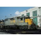
Etowah: Old Railroad
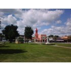
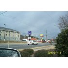
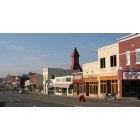
Etowah: Looking across the Memorial from The Train Depot and looking toward Needful Things etc..
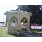
Etowah: The Bandstand at L& N

Etowah: Downton/Etowah Arts Comission and Gem Theatre
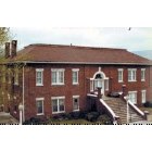
Etowah: Carnegie Library
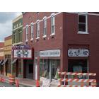
Etowah: Uptown Etowah
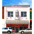
Etowah: Gem Theater

Etowah: Downtown Area - Ian's Market
Etowah: Talk of the Town
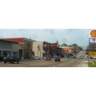
Etowah: Downtown Etowah/Ian's Market
Etowah: Downton
- see
20
more - add
your
Submit your own pictures of this city and show them to the world
- OSM Map
- General Map
- Google Map
- MSN Map
Population change since 2000: +0.2%
 |
| Males: 1,900 | |
| Females: 1,772 |
| Median resident age: | 41.0 years |
| Tennessee median age: | 39.2 years |
Zip codes: 37331.
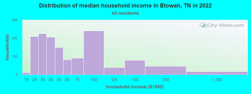
| Etowah: | $43,381 |
| TN: | $65,254 |
Estimated per capita income in 2022: $29,541 (it was $15,298 in 2000)
Etowah city income, earnings, and wages data
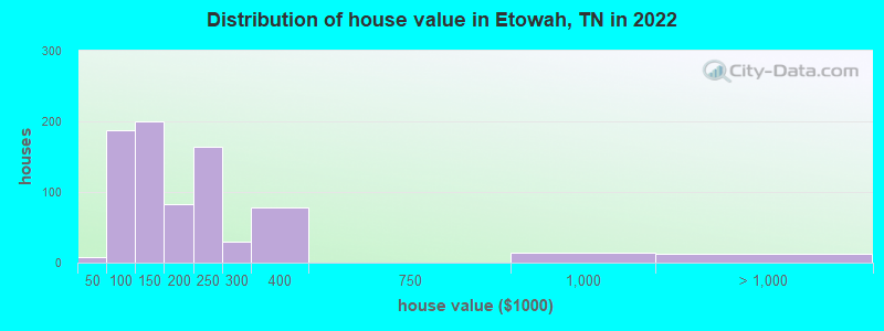
Estimated median house or condo value in 2022: $150,315 (it was $59,600 in 2000)
| Etowah: | $150,315 |
| TN: | $284,800 |
Mean prices in 2022: all housing units: $176,005; detached houses: $174,598
Median gross rent in 2022: $889.
(8.9% for White Non-Hispanic residents, 15.6% for Hispanic or Latino residents, 100.0% for other race residents, 49.3% for two or more races residents)
Detailed information about poverty and poor residents in Etowah, TN

Compare current foreclosures in Etowah, TN:
| Photo | Address | Area | Beds / Baths | Price | Details |
|---|---|---|---|---|---|

|
#1
Dunn St
Etowah, TN 37331
|
1,398 sq. feet
|
1 baths 3 beds |
show details | |

|
#2
County Road 495
Etowah, TN 37331
|
1,998 sq. feet
|
1 baths - beds |
show details | |

|
#3
Hitchcock Ave
Etowah, TN 37331
|
1,044 sq. feet
|
1 baths - beds |
show details | |

|
#4
Ohio Ave
Etowah, TN 37331
|
1,608 sq. feet
|
2 baths - beds |
show details | |

|
#5
Carroll St
Etowah, TN 37331
|
1,209 sq. feet
|
2 baths - beds |
show details | |

|
#6
Highway 411 N
Etowah, TN 37331
|
2,436 sq. feet
|
3 baths - beds |
show details | |

|
#7
Short St
Etowah, TN 37331
|
1,256 sq. feet
|
2 baths - beds |
show details | |

|
#8
County Road 784
Etowah, TN 37331
|
2,716 sq. feet
|
3 baths - beds |
show details | |

|
#9
Ohio Ave
Etowah, TN 37331
|
1,246 sq. feet
|
1 baths - beds |
show details | |

|
#10
County Road 660
Etowah, TN 37331
|
1,518 sq. feet
|
2 baths - beds |
show details |
| Photo | Address | Area | Beds / Baths | Price | Details |
|---|---|---|---|---|---|

|
#11
Amandas Trl
Etowah, TN 37331
|
848 sq. feet
|
2 baths - beds |
show details | |

|
#12
County Road 609
Etowah, TN 37331
|
1,320 sq. feet
|
2 baths - beds |
show details | |

|
#13
County Road 609
Etowah, TN 37331
|
1,674 sq. feet
|
2 baths - beds |
show details | |

|
#14
Washington Ave
Etowah, TN 37331
|
- sq. feet
|
- baths - beds |
show details | |

|
#15
14th St
Etowah, TN 37331
|
- sq. feet
|
- baths - beds |
show details | |

|
#16
Co. Road 801
Etowah, TN 37331
|
2,108 sq. feet
|
- baths - beds |
show details | |

|
#17
Stalans Dr
Etowah, TN 37331
|
- sq. feet
|
- baths - beds |
show details | |

|
#18
Oak St
Etowah, TN 37331
|
- sq. feet
|
- baths - beds |
show details | |

|
#19
Highway 411 N Apt 2
Etowah, TN 37331
|
- sq. feet
|
- baths - beds |
show details | |

|
#20
Brentwood Drive
Etowah, TN 37331
|
- sq. feet
|
- baths - beds |
show details |
| Photo | Address | Area | Beds / Baths | Price | Details |
|---|---|---|---|---|---|

|
#21
County Road 890
Etowah, TN 37331
|
- sq. feet
|
- baths - beds |
show details | |

|
#22
County Road 850
Etowah, TN 37331
|
- sq. feet
|
- baths - beds |
show details | |

|
#23
Mountain View Ests
Etowah, TN 37331
|
- sq. feet
|
- baths - beds |
show details | |

|
#24
9th St
Etowah, TN 37331
|
- sq. feet
|
- baths - beds |
show details | |

|
#25
8th St
Etowah, TN 37331
|
- sq. feet
|
- baths - beds |
show details | |

|
#26
3rd St
Etowah, TN 37331
|
- sq. feet
|
- baths - beds |
show details | |

|
#27
Indiana Ave
Etowah, TN 37331
|
- sq. feet
|
- baths - beds |
show details | |

|
#28
N Georgia Ave
Etowah, TN 37331
|
- sq. feet
|
- baths - beds |
show details | |

|
#29
County Road 497
Etowah, TN 37331
|
- sq. feet
|
- baths - beds |
show details | |

|
#30
County Road 809
Etowah, TN 37331
|
1,280 sq. feet
|
- baths - beds |
show details |
| Photo | Address | Area | Beds / Baths | Price | Details |
|---|---|---|---|---|---|

|
#31
County Road 804
Etowah, TN 37331
|
- sq. feet
|
- baths - beds |
show details | |

|
#32
County Road 881
Etowah, TN 37331
|
- sq. feet
|
- baths - beds |
show details | |

|
Check over 1 million property listings on Foreclosure.com!
|
browse all offers | |||


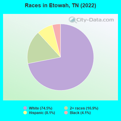
- 2,74174.5%White alone
- 62216.9%Two or more races
- 2998.1%Hispanic
- 1524.1%Black alone
Races in Etowah detailed stats: ancestries, foreign born residents, place of birth
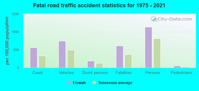
According to our research of Tennessee and other state lists, there were 20 registered sex offenders living in Etowah, Tennessee as of April 27, 2024.
The ratio of all residents to sex offenders in Etowah is 177 to 1.
Type |
2009 |
2010 |
2011 |
2012 |
2013 |
2014 |
2015 |
2016 |
2017 |
2018 |
2019 |
2020 |
2021 |
2022 |
|---|---|---|---|---|---|---|---|---|---|---|---|---|---|---|
| Murders (per 100,000) | 0 (0.0) | 0 (0.0) | 0 (0.0) | 0 (0.0) | 0 (0.0) | 0 (0.0) | 0 (0.0) | 0 (0.0) | 1 (28.5) | 0 (0.0) | 0 (0.0) | 0 (0.0) | 0 (0.0) | 0 (0.0) |
| Rapes (per 100,000) | 1 (26.4) | 2 (57.3) | 2 (56.8) | 6 (169.7) | 0 (0.0) | 1 (28.6) | 1 (28.5) | 0 (0.0) | 1 (28.5) | 1 (28.9) | 0 (0.0) | 1 (28.6) | 1 (28.3) | 2 (54.5) |
| Robberies (per 100,000) | 1 (26.4) | 0 (0.0) | 3 (85.2) | 1 (28.3) | 2 (57.3) | 1 (28.6) | 1 (28.5) | 0 (0.0) | 1 (28.5) | 0 (0.0) | 0 (0.0) | 0 (0.0) | 0 (0.0) | 0 (0.0) |
| Assaults (per 100,000) | 23 (607.3) | 16 (458.5) | 11 (312.4) | 19 (537.5) | 14 (401.3) | 7 (200.1) | 5 (142.5) | 16 (456.8) | 16 (455.6) | 16 (462.3) | 14 (402.1) | 24 (686.7) | 23 (651.6) | 13 (354.4) |
| Burglaries (per 100,000) | 23 (607.3) | 21 (601.7) | 43 (1,221) | 40 (1,132) | 32 (917.2) | 25 (714.5) | 22 (627.1) | 20 (570.9) | 36 (1,025) | 7 (202.3) | 11 (315.9) | 15 (429.2) | 9 (255.0) | 1 (27.3) |
| Thefts (per 100,000) | 77 (2,033) | 99 (2,837) | 96 (2,726) | 90 (2,546) | 100 (2,866) | 105 (3,001) | 121 (3,449) | 70 (1,998) | 50 (1,424) | 36 (1,040) | 66 (1,895) | 53 (1,516) | 65 (1,841) | 43 (1,172) |
| Auto thefts (per 100,000) | 2 (52.8) | 4 (114.6) | 10 (284.0) | 7 (198.0) | 5 (143.3) | 10 (285.8) | 3 (85.5) | 8 (228.4) | 11 (313.2) | 10 (288.9) | 12 (344.6) | 11 (314.7) | 14 (396.6) | 6 (163.6) |
| Arson (per 100,000) | 0 (0.0) | 0 (0.0) | 1 (28.4) | 3 (84.9) | 2 (57.3) | 0 (0.0) | 1 (28.5) | 2 (57.1) | 0 (0.0) | 1 (28.9) | 0 (0.0) | 1 (28.6) | 3 (85.0) | 0 (0.0) |
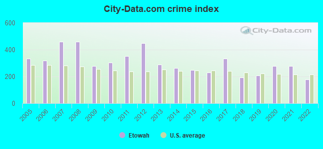
| City-Data.com crime index | 278.6 | 302.3 | 350.8 | 448.7 | 287.8 | 264.4 | 248.6 | 229.5 | 333.1 | 194.5 | 205.9 | 276.1 | 276.2 | 176.4 |
The City-Data.com crime index weighs serious crimes and violent crimes more heavily. Higher means more crime, U.S. average is 246.1. It adjusts for the number of visitors and daily workers commuting into cities.
Crime rate in Etowah detailed stats: murders, rapes, robberies, assaults, burglaries, thefts, arson
Full-time law enforcement employees in 2021, including police officers: 12 (11 officers - 9 male; 2 female).
| Officers per 1,000 residents here: | 3.12 |
| Tennessee average: | 2.57 |
 Recent articles from our blog. Our writers, many of them Ph.D. graduates or candidates, create easy-to-read articles on a wide variety of topics.

 | Etowah-Visting Relatives, Need local ride (Uber only?) (2 replies) |
| Looking into far East Tenn for mid age couple (45 replies) |
| Extreme Weather Warning For Some of Us Tonight (3 replies) |
| Want to move to East Tn from NM (18 replies) |
| Tennessee Urban Areas and Clusters (14 replies) |
| Best train rides near Knoxville (11 replies) |
Latest news from Etowah, TN collected exclusively by city-data.com from local newspapers, TV, and radio stations
Ancestries: American (22.0%), English (7.5%), European (6.4%), Irish (5.5%), German (4.4%), Scottish (2.5%).
Current Local Time: EST time zone
Incorporated in 1909
Elevation: 807 feet
Land area: 2.77 square miles.
Population density: 1,325 people per square mile (low).
168 residents are foreign born (4.4% Latin America).
| This city: | 4.6% |
| Tennessee: | 5.4% |
Median real estate property taxes paid for housing units with mortgages in 2022: $836 (0.6%)
Median real estate property taxes paid for housing units with no mortgage in 2022: $700 (0.4%)
Nearest city with pop. 50,000+: Chattanooga, TN  (46.2 miles , pop. 155,554).
Nearest city with pop. 200,000+: Atlanta, GA (108.8 miles , pop. 416,474).
Nearest city with pop. 1,000,000+: Chicago, IL (481.4 miles , pop. 2,896,016).
Nearest cities:
), ), ), Latitude: 35.33 N, Longitude: 84.53 W
Area code: 423

Etowah, Tennessee accommodation & food services, waste management - Economy and Business Data
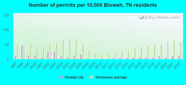
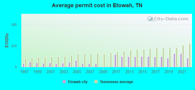
Single-family new house construction building permits:
- 2022: 5 buildings, average cost: $105,900
- 2021: 4 buildings, average cost: $158,000
- 2020: 3 buildings, average cost: $158,000
- 2019: 4 buildings, average cost: $107,000
- 2018: 2 buildings, average cost: $125,000
- 2017: 3 buildings, average cost: $122,300
- 2016: 3 buildings, average cost: $125,000
- 2015: 2 buildings, average cost: $125,000
- 2014: 2 buildings, average cost: $125,000
- 2013: 2 buildings, average cost: $125,000
- 2012: 2 buildings, average cost: $125,000
- 2011: 1 building, cost: $150,000
- 2008: 1 building, cost: $40,000
- 2007: 6 buildings, average cost: $42,600
- 2006: 5 buildings, average cost: $41,700
- 2005: 3 buildings, average cost: $76,700
- 2004: 4 buildings, average cost: $56,300
- 2003: 10 buildings, average cost: $47,200
- 2002: 10 buildings, average cost: $39,000
- 2001: 2 buildings, average cost: $47,500
- 2000: 5 buildings, average cost: $41,900
- 1999: 5 buildings, average cost: $51,000
- 1998: 17 buildings, average cost: $61,800
- 1997: 4 buildings, average cost: $42,800
| Here: | 3.7% |
| Tennessee: | 3.0% |
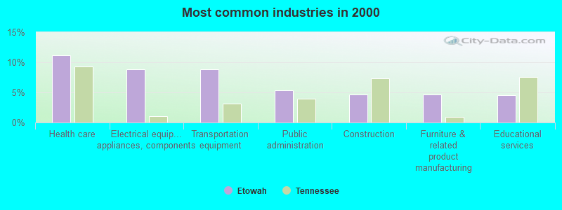
- Health care (11.2%)
- Electrical equipment, appliances, components (8.9%)
- Transportation equipment (8.8%)
- Public administration (5.3%)
- Construction (4.6%)
- Furniture & related product manufacturing (4.6%)
- Educational services (4.6%)
- Electrical equipment, appliances, components (10.2%)
- Transportation equipment (9.3%)
- Construction (6.7%)
- Public administration (6.5%)
- Furniture & related product manufacturing (5.1%)
- Accommodation & food services (4.7%)
- Plastics & rubber products (4.7%)
- Health care (20.2%)
- Educational services (8.3%)
- Transportation equipment (8.2%)
- Electrical equipment, appliances, components (7.3%)
- Apparel (5.1%)
- Finance & insurance (4.5%)
- Personal & laundry services (4.2%)
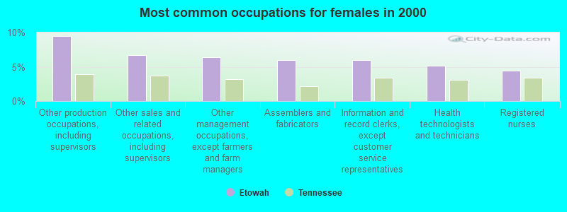
- Other production occupations, including supervisors (11.7%)
- Assemblers and fabricators (8.8%)
- Metal workers and plastic workers (6.6%)
- Other sales and related occupations, including supervisors (4.5%)
- Other management occupations, except farmers and farm managers (4.2%)
- Building and grounds cleaning and maintenance occupations (3.7%)
- Information and record clerks, except customer service representatives (3.1%)
- Other production occupations, including supervisors (13.5%)
- Assemblers and fabricators (11.1%)
- Metal workers and plastic workers (10.2%)
- Building and grounds cleaning and maintenance occupations (5.1%)
- Other material moving workers, except laborers (4.2%)
- Cooks and food preparation workers (4.0%)
- Laborers and material movers, hand (3.4%)
- Other production occupations, including supervisors (9.5%)
- Other sales and related occupations, including supervisors (6.7%)
- Other management occupations, except farmers and farm managers (6.4%)
- Assemblers and fabricators (5.9%)
- Information and record clerks, except customer service representatives (5.9%)
- Health technologists and technicians (5.2%)
- Registered nurses (4.5%)
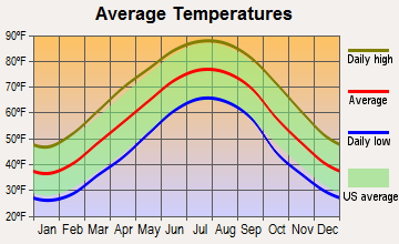
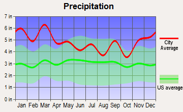
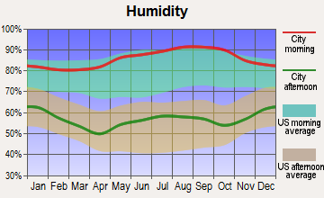
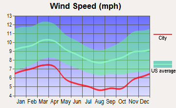
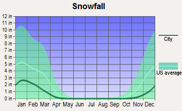
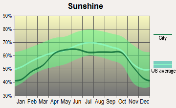
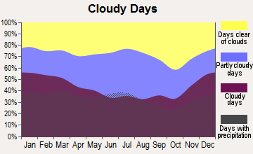
Average climate in Etowah, Tennessee
Based on data reported by over 4,000 weather stations
|
|

(lower is better)
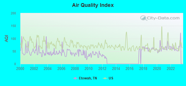
Air Quality Index (AQI) level in 2022 was 59.3. This is better than average.
| City: | 59.3 |
| U.S.: | 72.6 |
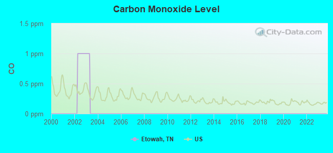
Carbon Monoxide (CO) [ppm] level in 2002 was 1.00. This is significantly worse than average. Closest monitor was 13.5 miles away from the city center.
| City: | 1.00 |
| U.S.: | 0.25 |
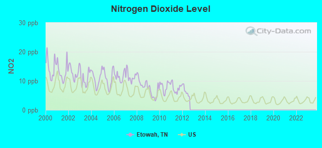
Nitrogen Dioxide (NO2) [ppb] level in 2012 was 6.47. This is worse than average. Closest monitor was 12.8 miles away from the city center.
| City: | 6.47 |
| U.S.: | 5.11 |
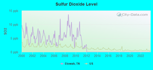
Sulfur Dioxide (SO2) [ppb] level in 2011 was 2.26. This is significantly worse than average. Closest monitor was 13.4 miles away from the city center.
| City: | 2.26 |
| U.S.: | 1.51 |
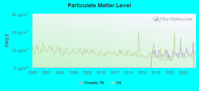
Particulate Matter (PM2.5) [µg/m3] level in 2022 was 7.80. This is about average. Closest monitor was 9.2 miles away from the city center.
| City: | 7.80 |
| U.S.: | 8.11 |
Tornado activity:
Etowah-area historical tornado activity is slightly below Tennessee state average. It is 2% greater than the overall U.S. average.
On 5/2/1953, a category F4 (max. wind speeds 207-260 mph) tornado 17.6 miles away from the Etowah city center killed 4 people and injured 8 people and caused between $50,000 and $500,000 in damages.
On 4/3/1974, a category F3 (max. wind speeds 158-206 mph) tornado 1.4 miles away from the city center killed 3 people and injured 50 people and caused between $50,000 and $500,000 in damages.
Earthquake activity:
Etowah-area historical earthquake activity is significantly above Tennessee state average. It is 92% greater than the overall U.S. average.On 4/29/2003 at 08:59:39, a magnitude 4.9 (4.4 MB, 4.6 MW, 4.9 LG, Class: Light, Intensity: IV - V) earthquake occurred 85.1 miles away from the city center
On 11/30/1973 at 07:48:41, a magnitude 4.7 (4.7 MB, 4.6 ML) earthquake occurred 45.5 miles away from the city center
On 12/12/2018 at 09:14:43, a magnitude 4.4 (4.4 MW, Depth: 4.9 mi) earthquake occurred 22.7 miles away from the city center
On 7/27/1980 at 18:52:21, a magnitude 5.2 (5.1 MB, 4.7 MS, 5.0 UK, 5.2 UK, Class: Moderate, Intensity: VI - VII) earthquake occurred 201.5 miles away from the city center
On 4/29/2003 at 08:59:39, a magnitude 4.6 (4.6 MW, Depth: 12.3 mi) earthquake occurred 85.1 miles away from Etowah center
On 8/2/1974 at 08:52:09, a magnitude 4.9 (4.3 MB, 4.9 LG) earthquake occurred 153.8 miles away from the city center
Magnitude types: regional Lg-wave magnitude (LG), body-wave magnitude (MB), local magnitude (ML), surface-wave magnitude (MS), moment magnitude (MW)
Natural disasters:
The number of natural disasters in McMinn County (12) is smaller than the US average (15).Major Disasters (Presidential) Declared: 9
Emergencies Declared: 2
Causes of natural disasters: Floods: 6, Tornadoes: 5, Storms: 4, Winter Storms: 3, Flash Floods: 2, Heavy Rains: 2, Winds: 2, Hurricane: 1, Ice Storm: 1, Snowfall: 1, Other: 1 (Note: some incidents may be assigned to more than one category).
Hospitals and medical centers in Etowah:
- WOODS MEMORIAL HOSP HOSPICE (HIWASSEE VILLAGE SHOPPING CTR HWY 411N)
- WOODS MEMORIAL HOSPITAL (Government - Hospital District or Authority, 886 HIGHWAY 411 NORTH)
- ETOWAH HEALTH CARE CENTER (409 GRADY ROAD, PO BOX 957)
- MCMINN MEMORIAL NH (PO BOX 410)
- MCMINN MEMORIAL NURSING HOME AND REHAB CENTER (886 HWY 411 NORTH)
- TOTAL RENAL CARE, INC. (109 GRADY RD)
- WOODS HOME HEALTH, LLC (916 HIGHWAY 411 NORTH)
Colleges/universities with over 2000 students nearest to Etowah:
- Cleveland State Community College (about 22 miles; Cleveland, TN; Full-time enrollment: 2,500)
- Lee University (about 23 miles; Cleveland, TN; FT enrollment: 4,422)
- Southern Adventist University (about 36 miles; Collegedale, TN; FT enrollment: 2,898)
- Roane State Community College (about 39 miles; Harriman, TN; FT enrollment: 4,302)
- Chattanooga State Community College (about 44 miles; Chattanooga, TN; FT enrollment: 6,827)
- Dalton State College (about 47 miles; Dalton, GA; FT enrollment: 3,846)
- Pellissippi State Community College (about 48 miles; Knoxville, TN; FT enrollment: 7,271)
Public elementary/middle schools in Etowah:
- MOUNTAIN VIEW ELEMENTARY (Students: 715, Location: 145 CO 627 RD, Grades: PK-8)
- ETOWAH ELEMENTARY (Students: 411, Location: 858 EIGHTH ST, Grades: PK-8)
User-submitted facts and corrections:
- Gateway Church of Christ
Points of interest:
Notable locations in Etowah: Hiawassee Ranger Station (A), Hiwassee Work Center (B), McMinn County District 4 Etowah Fire and Rescue (C), City of Etowah Fire Department (D), Etowah City Hall (E). Display/hide their locations on the map
Churches in Etowah include: First Baptist Church (A), Wesley Memorial Methodist Church (B), Saint Pauls Methodist Church (C), North Etowah Baptist Church (D), Brookhill Baptist Church (E). Display/hide their locations on the map
Cemetery: New Zion Cemetery (1). Display/hide its location on the map
Tourist attraction: Etowah Depot (Museums; 727 Tennessee Avenue).
Hotels: Etowah Mini Golf (322 North Tennessee Avenue), Holiday Terrace Motel (322 North Tennessee Avenue).
Birthplace of: Leon Daniel - Recipient of the Purple Heart medal.
Drinking water stations with addresses in Etowah and their reported violations in the past:
ETOWAH UTILITIES (Population served: 11,938, Surface water):Past monitoring violations:
- Monitoring, Source Water (LT2) - In JAN-2009, Contaminant: E. COLI. Follow-up actions: St Compliance achieved (FEB-04-2009), St Public Notif requested (NOV-24-2010), St Violation/Reminder Notice (NOV-24-2010)
- Monitoring, Source Water (LT2) - In DEC-2008, Contaminant: E. COLI. Follow-up actions: St Compliance achieved (FEB-04-2009), St Public Notif requested (NOV-24-2010), St Violation/Reminder Notice (NOV-24-2010)
- Monitoring, Source Water (LT2) - In NOV-2008, Contaminant: E. COLI. Follow-up actions: St Compliance achieved (FEB-04-2009), St Public Notif requested (NOV-24-2010), St Violation/Reminder Notice (NOV-24-2010)
| This city: | 2.3 people |
| Tennessee: | 2.5 people |
| This city: | 60.3% |
| Whole state: | 67.3% |
| This city: | 6.2% |
| Whole state: | 5.8% |
Likely homosexual households (counted as self-reported same-sex unmarried-partner households)
- Lesbian couples: 0.3% of all households
- Gay men: 0.1% of all households
People in group quarters in Etowah in 2000:
- 176 people in nursing homes
- 6 people in hospitals/wards and hospices for chronically ill
- 6 people in other hospitals or wards for chronically ill
Banks with branches in Etowah (2011 data):
- First Volunteer Bank of Tennessee: Etowah Branch at 515 North Tennessee Avenue, branch established on 1932/09/01. Info updated 2008/10/30: Bank assets: $641.6 mil, Deposits: $561.9 mil, headquarters in Chattanooga, TN, positive income, Commercial Lending Specialization, 23 total offices, Holding Company: First Volunteer Corporation
- Athens Federal Community Bank: 623 Tennessee Avenue Branch at 623 Tennessee Avenue, branch established on 1934/08/01. Info updated 2011/07/21: Bank assets: $283.3 mil, Deposits: $231.4 mil, headquarters in Athens, TN, positive income, Commercial Lending Specialization, 7 total offices
- Branch Banking and Trust Company: Etowah Branch at 601 Tennessee Avenue, branch established on 1964/11/30. Info updated 2010/03/29: Bank assets: $168,867.6 mil, Deposits: $127,549.5 mil, headquarters in Winston Salem, NC, positive income, Commercial Lending Specialization, 1793 total offices, Holding Company: Bb&T Corporation
- The Citizens National Bank of Athens: Etowah Branch at 843 Highway 411 North, branch established on 1993/11/17. Info updated 2006/11/03: Bank assets: $534.9 mil, Deposits: $464.3 mil, headquarters in Athens, TN, negative income in the last year, Commercial Lending Specialization, 9 total offices, Holding Company: Citizens National Bancorp, Inc.
For population 15 years and over in Etowah:
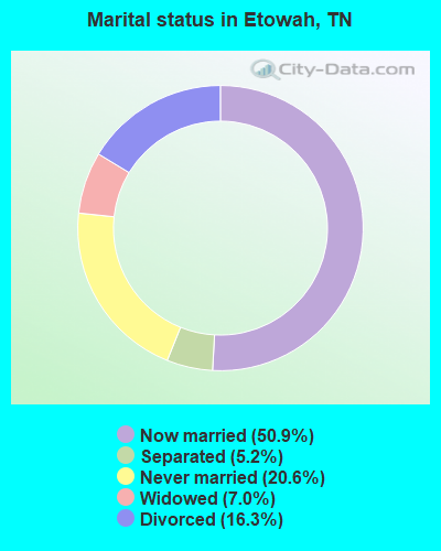
- Never married: 20.6%
- Now married: 50.9%
- Separated: 5.2%
- Widowed: 7.0%
- Divorced: 16.3%
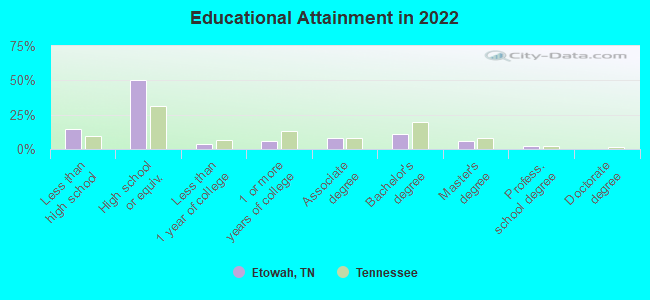
For population 25 years and over in Etowah:
- High school or higher: 83.4%
- Bachelor's degree or higher: 17.3%
- Graduate or professional degree: 7.4%
- Unemployed: 3.7%
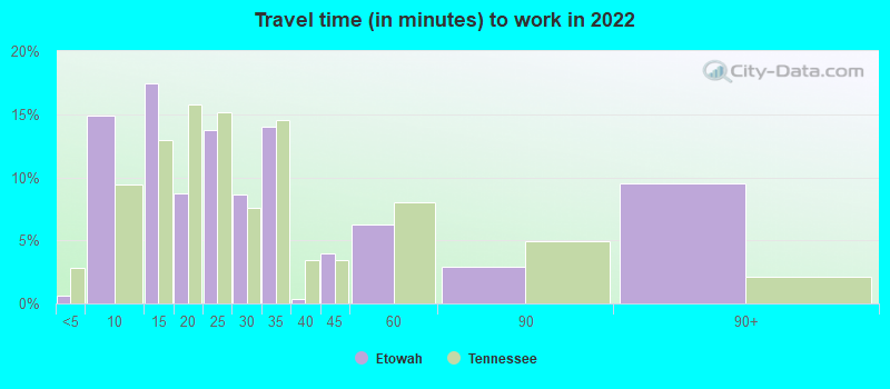
- Mean travel time to work (commute): 24.8 minutes
| Here: | 11.9 |
| Tennessee average: | 11.4 |
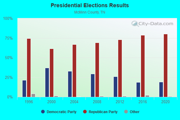
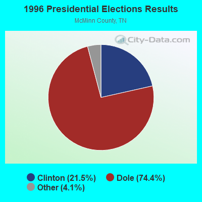
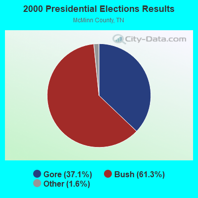
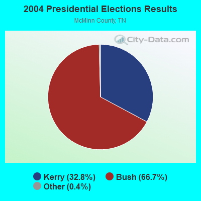
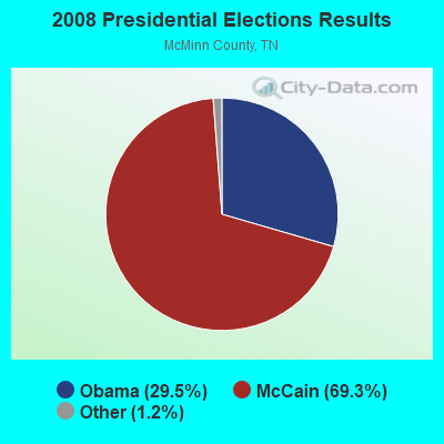

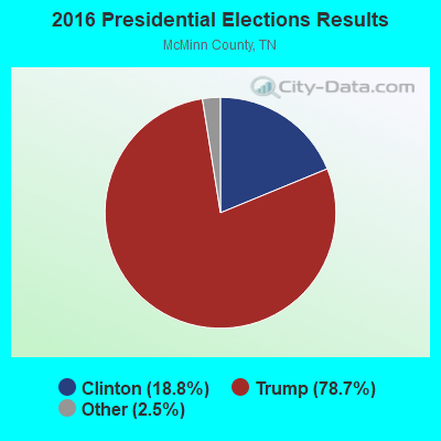
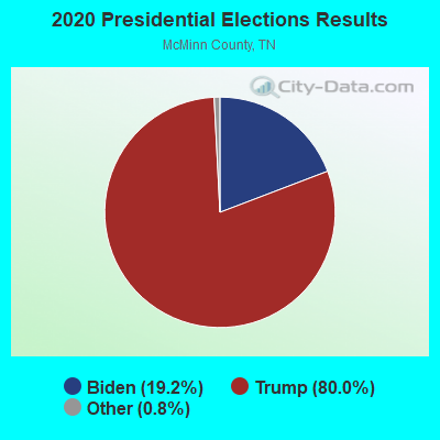
Graphs represent county-level data. Detailed 2008 Election Results
Religion statistics for Etowah, TN (based on McMinn County data)
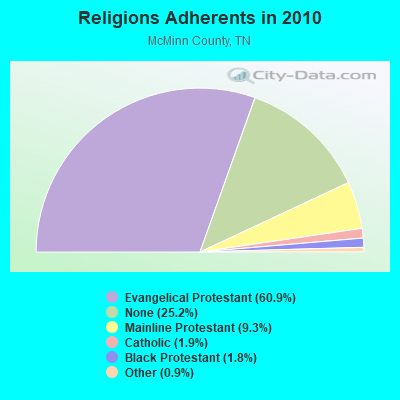
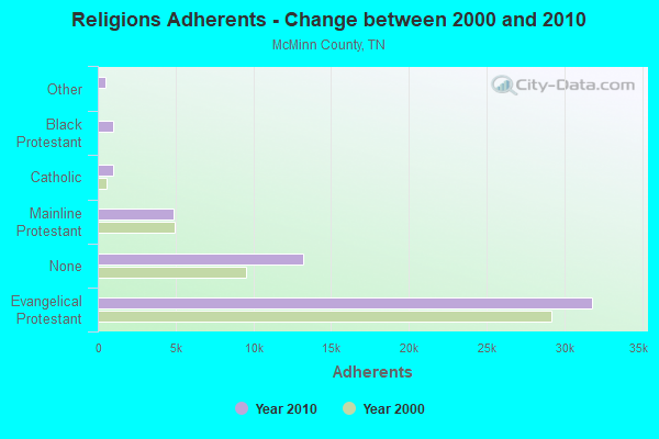
| Religion | Adherents | Congregations |
|---|---|---|
| Evangelical Protestant | 31,806 | 112 |
| Mainline Protestant | 4,849 | 23 |
| Catholic | 986 | 1 |
| Black Protestant | 966 | 6 |
| Other | 464 | 2 |
| None | 13,195 | - |
Food Environment Statistics:
| This county: | 1.15 / 10,000 pop. |
| Tennessee: | 1.99 / 10,000 pop. |
| McMinn County: | 0.38 / 10,000 pop. |
| Tennessee: | 0.65 / 10,000 pop. |
| Here: | 6.92 / 10,000 pop. |
| Tennessee: | 5.16 / 10,000 pop. |
| This county: | 4.42 / 10,000 pop. |
| Tennessee: | 6.56 / 10,000 pop. |
| Here: | 11.3% |
| Tennessee: | 11.4% |
| McMinn County: | 32.7% |
| Tennessee: | 30.2% |
| Here: | 14.6% |
| Tennessee: | 13.5% |
Health and Nutrition:
| This city: | 49.8% |
| State: | 49.3% |
| Etowah: | 45.4% |
| State: | 46.1% |
| Here: | 29.6 |
| Tennessee: | 28.8 |
| Here: | 20.4% |
| Tennessee: | 21.0% |
| This city: | 14.7% |
| Tennessee: | 10.5% |
| Here: | 6.9 |
| State: | 6.8 |
| Etowah: | 36.9% |
| Tennessee: | 33.9% |
| This city: | 55.1% |
| State: | 55.9% |
| Etowah: | 75.3% |
| State: | 79.1% |
More about Health and Nutrition of Etowah, TN Residents
| Local government employment and payroll (March 2022) | |||||
| Function | Full-time employees | Monthly full-time payroll | Average yearly full-time wage | Part-time employees | Monthly part-time payroll |
|---|---|---|---|---|---|
| Elementary and Secondary - Instruction | 47 | $151,273 | $38,623 | 23 | $19,675 |
| Elementary and Secondary - Other Total | 12 | $29,513 | $29,513 | 8 | $1,909 |
| Police Protection - Officers | 8 | $32,008 | $48,012 | 3 | $1,909 |
| Firefighters | 6 | $21,595 | $43,190 | 5 | $1,769 |
| Parks and Recreation | 5 | $15,121 | $36,290 | 11 | $4,052 |
| Streets and Highways | 4 | $11,080 | $33,240 | 0 | $0 |
| Other Government Administration | 4 | $19,689 | $59,067 | 4 | $400 |
| Solid Waste Management | 3 | $6,849 | $27,396 | 1 | $1,032 |
| Local Libraries | 1 | $2,569 | $30,828 | 2 | $414 |
| Financial Administration | 1 | $3,996 | $47,952 | 0 | $0 |
| Judicial and Legal | 1 | $6,154 | $73,848 | 0 | $0 |
| Police - Other | 1 | $4,634 | $55,608 | 0 | $0 |
| Other and Unallocable | 0 | $0 | 1 | $496 | |
| Totals for Government | 93 | $304,482 | $39,288 | 58 | $31,656 |
Etowah government finances - Expenditure in 2017 (per resident):
- Construction - Elementary and Secondary Education: $12,000 ($3.27)
- Current Operations - Elementary and Secondary Education: $3,333,000 ($907.68)
Police Protection: $674,000 ($183.55)
Central Staff Services: $619,000 ($168.57)
Parks and Recreation: $451,000 ($122.82)
Local Fire Protection: $376,000 ($102.40)
General - Other: $332,000 ($90.41)
General Public Buildings: $314,000 ($85.51)
Solid Waste Management: $293,000 ($79.79)
Regular Highways: $255,000 ($69.44)
Financial Administration: $138,000 ($37.58)
Protective Inspection and Regulation - Other: $126,000 ($34.31)
Libraries: $80,000 ($21.79)
Judicial and Legal Services: $10,000 ($2.72)
- General - Interest on Debt: $58,000 ($15.80)
- Other Capital Outlay - Elementary and Secondary Education: $227,000 ($61.82)
Libraries: $85,000 ($23.15)
Parks and Recreation: $50,000 ($13.62)
Solid Waste Management: $46,000 ($12.53)
- Total Salaries and Wages: $2,153,000 ($586.33)
Etowah government finances - Revenue in 2017 (per resident):
- Charges - Solid Waste Management: $299,000 ($81.43)
Parks and Recreation: $111,000 ($30.23)
Elementary and Secondary Education School Lunch: $17,000 ($4.63)
- Federal Intergovernmental - Education: $202,000 ($55.01)
- Local Intergovernmental - Education: $827,000 ($225.22)
General Local Government Support: $536,000 ($145.97)
Highways: $12,000 ($3.27)
- Miscellaneous - Fines and Forfeits: $193,000 ($52.56)
General Revenue - Other: $116,000 ($31.59)
Rents: $98,000 ($26.69)
Donations From Private Sources: $92,000 ($25.05)
Sale of Property: $8,000 ($2.18)
Interest Earnings: $3,000 ($0.82)
- State Intergovernmental - Education: $2,721,000 ($741.01)
Other: $306,000 ($83.33)
Highways: $249,000 ($67.81)
- Tax - Property: $1,048,000 ($285.40)
General Sales and Gross Receipts: $706,000 ($192.27)
Alcoholic Beverage Sales: $215,000 ($58.55)
Occupation and Business License - Other: $55,000 ($14.98)
Other: $21,000 ($5.72)
Other License: $2,000 ($0.54)
Alcoholic Beverage License: $1,000 ($0.27)
Etowah government finances - Debt in 2017 (per resident):
- Long Term Debt - Beginning Outstanding - Unspecified Public Purpose: $1,443,000 ($392.97)
Outstanding Unspecified Public Purpose: $1,399,000 ($380.99)
Retired Unspecified Public Purpose: $177,000 ($48.20)
Issue, Unspecified Public Purpose: $133,000 ($36.22)
Etowah government finances - Cash and Securities in 2017 (per resident):
- Other Funds - Cash and Securities: $1,592,000 ($433.55)
| Businesses in Etowah, TN | ||||
| Name | Count | Name | Count | |
|---|---|---|---|---|
| Advance Auto Parts | 1 | Pizza Hut | 1 | |
| AutoZone | 1 | Red Roof Inn | 1 | |
| Domino's Pizza | 1 | Rite Aid | 1 | |
| FedEx | 1 | SONIC Drive-In | 1 | |
| Hardee's | 1 | Subway | 1 | |
| KFC | 1 | True Value | 1 | |
| McDonald's | 1 | U-Haul | 1 | |
Strongest AM radio stations in Etowah:
- WCPH (1220 AM; 1 kW; ETOWAH, TN; Owner: STARR MOUNTAIN BROADCASTING CO.)
- WYXI (1390 AM; 2 kW; ATHENS, TN; Owner: CORNERSTONE BROADCASTING, INC.)
- WENR (1090 AM; daytime; 1 kW; ENGLEWOOD, TN; Owner: PAUL WILSON D/B/A/ 1090 RADIO, A TEN)
- WFLI (1070 AM; 50 kW; LOOKOUT MOUNTAIN, TN; Owner: WFLI, INC.)
- WKVL (850 AM; daytime; 50 kW; KNOXVILLE, TN; Owner: HORNE RADIO, LLC)
- WWAM (820 AM; daytime; 50 kW; JASPER, TN; Owner: SHELTON BROADCASTING SYSTEM)
- WLAR (1450 AM; 1 kW; ATHENS, TN; Owner: JAMES C. SLIGER)
- WCNN (680 AM; 50 kW; NORTH ATLANTA, GA; Owner: DICKEY BROADCASTING COMPANY)
- WCLE (1570 AM; 5 kW; CLEVELAND, TN)
- WGST (640 AM; 50 kW; ATLANTA, GA; Owner: CITICASTERS LICENSES, L.P.)
- WSB (750 AM; 50 kW; ATLANTA, GA; Owner: CXR HOLDINGS, INC.)
- WFTD (1080 AM; daytime; 50 kW; MARIETTA, GA; Owner: PRIETO ENTERPRISES, INC.)
- WLFJ (660 AM; daytime; 50 kW; GREENVILLE, SC; Owner: CLEAR CHANNEL BROADCASTING LICENSES, INC.)
Strongest FM radio stations in Etowah:
- WLLJ (103.1 FM; ETOWAH, TN; Owner: FRIENDSHIP BROADCASTING LLC.)
- WYGO (99.5 FM; MADISONVILLE, TN; Owner: MAJOR BROADCASTING CORPORATION)
- WJSQ (101.7 FM; ATHENS, TN; Owner: JAMES C. SLIGER)
- WCVP-FM (95.9 FM; ROBBINSVILLE, NC; Owner: CHEROKEE BROADCASTING COMPANY, INC.)
- W234AG (94.7 FM; CHATSWORTH, GA; Owner: IMMANUEL BROADCASTING NETWORK, INC.)
- WFQS (91.3 FM; FRANKLIN, NC; Owner: WESTERN NORTH CAROLINA PUBLIC RADIO)
- WCLE-FM (104.1 FM; CALHOUN, TN; Owner: WILLIAMS COMMUNICATIONS, INC.)
- WLOD-FM (98.3 FM; SWEETWATER, TN; Owner: HORNE RADIO, LLC)
- WMKW (89.3 FM; CROSSVILLE, TN; Owner: THE MOODY BIBLE INSTITUTE OF CHICAGO)
- WOKI-FM (100.3 FM; OAK RIDGE, TN; Owner: OAK RIDGE FM, INC.)
- WUSY (100.7 FM; CLEVELAND, TN; Owner: CAPSTAR TX LIMITED PARTNERSHIP)
- WIVK-FM (107.7 FM; KNOXVILLE, TN; Owner: CITADEL BROADCASTING COMPANY)
- WWSR (105.7 FM; ROCKWOOD, TN; Owner: SOUTHERN MEDIA GROUP, INC.)
- WWST (102.1 FM; SEVIERVILLE, TN; Owner: JOURNAL BROADCAST CORPORATION)
- WALV (95.3 FM; CLEVELAND, TN; Owner: J. L. BREWER BROADCASTING OF CLEVELAND, LLC)
- WDVX (89.9 FM; CLINTON, TN; Owner: CUMBERLAND COMMUNITIES COMMUNI CORP.)
- WSMC-FM (90.5 FM; COLLEGEDALE, TN; Owner: SOUTHERN COLLEGE OF SEVENTH-DAY ADVT)
- WMBW (88.9 FM; CHATTANOOGA, TN; Owner: THE MOODY BIBLE INSTITUTE OF CHICAGO)
- WOCE (93.1 FM; BENTON, TN; Owner: LB RADIO OF CHATTANOOGA, LLC)
- WDNT-FM (104.9 FM; DAYTON, TN; Owner: J. L. BREWER BROADCASTING OF CLEVELAND, LLC)
TV broadcast stations around Etowah:
- W50AB (Channel 50; HIAWASSEE, GA; Owner: GEORGIA PUBLIC TELECOMMUNICATIONS COMMISSION)
- WFLI-TV (Channel 53; CLEVELAND, TN; Owner: CHATTANOOGA MEDIA HOLDINGS, L.L.C.)
- WDTT-LP (Channel 38; LENOIR CITY, TN; Owner: WORD OF GOD FELLOWSHIP, INC.)
- WPDP-LP (Channel 25; CLEVELAND, TN; Owner: WDSI LICENSE CORP.)
- National Bridge Inventory (NBI) Statistics
- 27Number of bridges
- 318ft / 96.8mTotal length
- $736,000Total costs
- 71,712Total average daily traffic
- 6,819Total average daily truck traffic
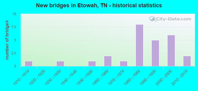
- New bridges - historical statistics
- 11910-1919
- 11930-1939
- 11950-1959
- 21960-1969
- 11970-1979
- 81980-1989
- 51990-1999
- 62000-2009
- 22010-2019
FCC Registered Cell Phone Towers:
2 (See the full list of FCC Registered Cell Phone Towers in Etowah)FCC Registered Antenna Towers:
35 (See the full list of FCC Registered Antenna Towers)FCC Registered Broadcast Land Mobile Towers:
17 (See the full list of FCC Registered Broadcast Land Mobile Towers in Etowah, TN)FCC Registered Microwave Towers:
6- 508 Tennessee Ave (Lat: 35.326167 Lon: -84.524083), Overall height: 10.7 m, Call Sign: WMV439,
Assigned Frequencies: 948.000 MHz, Grant Date: 02/16/1995, Expiration Date: 08/01/2028, Phone: (615) 338-2864
- STARR MTN, Starr Mtn Firetower (Lat: 35.324750 Lon: -84.452444), Type: Ltower, Structure height: 54.9 m, Call Sign: WNEX885,
Assigned Frequencies: 955.150 MHz, 955.550 MHz, 953.950 MHz, Grant Date: 02/20/2019, Expiration Date: 05/16/2029, Registrant: Tennessee Div. Of Forestry, Bruer Building, 440 Hogan Road, Nashville, TN 37220, Phone: (615) 837-5520, Fax: (615) 837-5003, Email:
- ETOWAH, 2.5 Mi Sw (Lat: 35.297222 Lon: -84.563889), Type: Gtower, Structure height: 54.9 m, Overall height: 59.4 m, Call Sign: WPXE841,
Assigned Frequencies: 6256.54 MHz, Grant Date: 02/22/2023, Expiration Date: 03/19/2033, Certifier: Douglas W Chambers, Registrant: Wilkinson Barker Knauer, LLP, 1800 M Street Nw, Suite 800n, Washington, DC 20036, Phone: (202) 383-3420, Fax: (202) 783-5851, Email:
- STARR MTN, Bullet Rd 4.1 Miles East Of (Lat: 35.324833 Lon: -84.452444), Type: Ltower, Structure height: 54.9 m, Call Sign: WQKI732,
Assigned Frequencies: 5974.85 MHz, 6123.10 MHz, Grant Date: 03/08/2019, Expiration Date: 06/04/2029, Certifier: Arnold Hooper, Registrant: City Of Chattanooga, 910 Wisdom Street, Chattanooga, TN 37406, Phone: (423) 643-5236, Email:
- ETOWAH, County Road 526 (Lat: 35.354083 Lon: -84.538806), Type: Ltower, Structure height: 82.3 m, Overall height: 85 m, Call Sign: WQMZ206,
Assigned Frequencies: 10935.0 MHz, 10935.0 MHz, 10935.0 MHz, 10935.0 MHz, 10935.0 MHz, 10935.0 MHz, 10935.0 MHz, 10935.0 MHz, 11015.0 MHz, 11015.0 MHz... (+20 more), Grant Date: 10/14/2020, Expiration Date: 11/15/2030, Certifier: Gregory M Romano, Registrant: Verizon Wireless, 5055 North Point Pkwy, Np2ne Network Engineering, Alpharetta, GA 30022, Phone: (770) 797-1070, Email:
- STATION, In L & N Rr Yard, E Of Us Hwy 411, S Of 8th St (Lat: 35.321722 Lon: -84.523806), Structure height: 14 m, Overall height: 17.1 m, Call Sign: WED264,
Assigned Frequencies: 1965.00 MHz, Grant Date: 01/17/1996, Expiration Date: 01/17/2001, Cancellation Date: 04/22/2001, Phone: (904) 359-1329
FCC Registered Amateur Radio Licenses:
93 (See the full list of FCC Registered Amateur Radio Licenses in Etowah)FAA Registered Aircraft:
2- Aircraft: CESSNA 150M (Category: Land, Seats: 2, Weight: Up to 12,499 Pounds, Speed: 81 mph), Engine: CONT MOTOR 0-200 SERIES (100 HP) (4 Cycle)
N-Number: 704TV, N704TV, N-704TV, Serial Number: 15078869, Year manufactured: 1976, Airworthiness Date: 10/28/1976
Registrant (Individual): Pending Registration, 296 County Road 804, Etowah, TN 37331 - Aircraft: PIPER PA-23-250 (Category: Land, Engines: 2, Seats: 6, Weight: Up to 12,499 Pounds, Speed: 150 mph), Engine: LYCOMING TI0-540 SER (310 HP) (Reciprocating)
N-Number: 44HJ, N44HJ, N-44HJ, Serial Number: 27-3303, Year manufactured: 1966, Airworthiness Date: 05/26/1966, Certificate Issue Date: 04/22/2013
Registrant (Individual): Mary Jo Yarbrough, 556 County Road 890, Etowah, TN 37331
2002 - 2018 National Fire Incident Reporting System (NFIRS) incidents
- Fire incident types reported to NFIRS in Etowah, TN
- 57644.3%Structure Fires
- 52140.1%Outside Fires
- 16112.4%Mobile Property/Vehicle Fires
- 423.2%Other
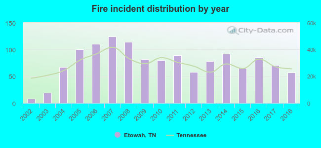 Based on the data from the years 2002 - 2018 the average number of fires per year is 76. The highest number of reported fires - 124 took place in 2007, and the least - 8 in 2002. The data has a rising trend.
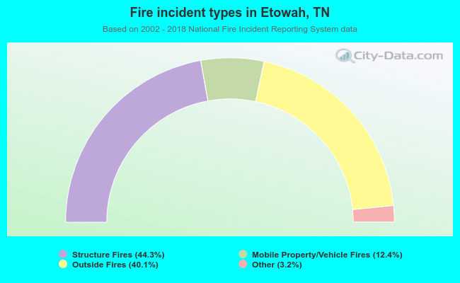 When looking into fire subcategories, the most reports belonged to: Structure Fires (44.3%), and Outside Fires (40.1%).
Fire-safe hotels and motels in Etowah, Tennessee:
- Sleep Inn, Tennessee Ave, Us Hwy 411, Etowah, Tennessee 37331 , Phone: (423) 263-4343, Fax: (423) 263-4353
- Red Roof Inn, 600 N Tennessee Ave, Etowah, Tennessee 37331 , Phone: (423) 781-7459, Fax: (423) 781-7474
| Most common first names in Etowah, TN among deceased individuals | ||
| Name | Count | Lived (average) |
|---|---|---|
| William | 94 | 72.7 years |
| James | 94 | 73.3 years |
| John | 75 | 77.0 years |
| Mary | 67 | 77.8 years |
| Charles | 53 | 70.7 years |
| Robert | 52 | 70.3 years |
| George | 34 | 77.2 years |
| Margaret | 29 | 76.6 years |
| Roy | 23 | 72.2 years |
| Thomas | 22 | 72.4 years |
| Most common last names in Etowah, TN among deceased individuals | ||
| Last name | Count | Lived (average) |
|---|---|---|
| Smith | 46 | 69.5 years |
| Williams | 46 | 74.7 years |
| Wilson | 38 | 79.4 years |
| Green | 37 | 74.8 years |
| Johnson | 31 | 74.3 years |
| Miller | 29 | 77.5 years |
| Brown | 26 | 76.3 years |
| King | 24 | 74.4 years |
| Newman | 24 | 72.1 years |
| Stewart | 23 | 76.4 years |
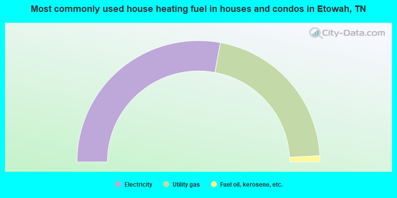
- 55.8%Electricity
- 42.6%Utility gas
- 1.6%Fuel oil, kerosene, etc.
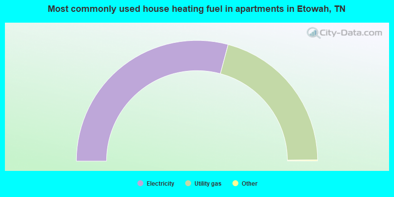
- 58.5%Electricity
- 41.5%Utility gas
Etowah compared to Tennessee state average:
- Median household income below state average.
- Median house value below state average.
- Unemployed percentage significantly below state average.
- Black race population percentage significantly below state average.
- Median age above state average.
- Institutionalized population percentage above state average.
- Number of college students below state average.

|
Total of 6 patent applications in 2008-2024.