Evanston, Wyoming
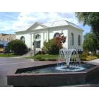
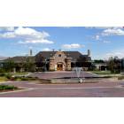
Evanston: Historic Downtown Evanston
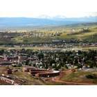
Evanston: Downtown Evanston, Wyoming
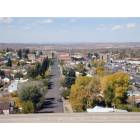
Evanston: Main Street Evanston, Wyoming
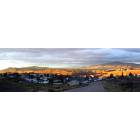
Evanston: Evanston Sunset
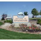
Evanston: Welcome to Evanston
Evanston: Historic Depot Square
Evanston: The Bear River from bridge
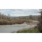
Evanston: The Bear River
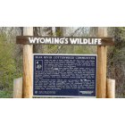
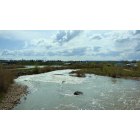
Evanston: The Bear River Wildlife
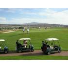
Evanston: Purple Sage Golf Course
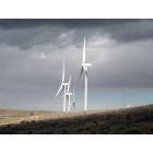
Evanston: Wind Farm
- add
your
Submit your own pictures of this city and show them to the world
- OSM Map
- General Map
- Google Map
- MSN Map
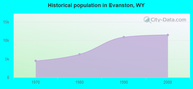
Population change since 2000: +2.9%
| Males: 5,895 | |
| Females: 5,950 |
| Median resident age: | 36.3 years |
| Wyoming median age: | 39.1 years |
Zip codes: 82930.
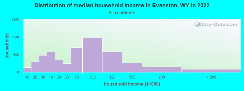
| Evanston: | $68,429 |
| WY: | $70,042 |
Estimated per capita income in 2022: $29,292 (it was $16,725 in 2000)
Evanston city income, earnings, and wages data
Estimated median house or condo value in 2022: $214,433 (it was $81,200 in 2000)
| Evanston: | $214,433 |
| WY: | $292,300 |
Median gross rent in 2022: $696.
(5.7% for White Non-Hispanic residents, 12.6% for Hispanic or Latino residents, 2.4% for American Indian residents, 26.0% for other race residents, 6.4% for two or more races residents)
Detailed information about poverty and poor residents in Evanston, WY

Compare current foreclosures near Evanston, WY:
| Photo | Address | Area | Beds / Baths | Price | Details |
|---|---|---|---|---|---|

|
#1
Hunt Ave
Evanston, WY 82930
|
1,300 sq. feet
|
- baths - beds |
$69,900
|
show details |

|
#2
Wall St
Evanston, WY 82930
|
1,575 sq. feet
|
- baths 3 beds |
show details | |

|
#3
W Center St
Evanston, WY 82930
|
- sq. feet
|
- baths - beds |
show details | |

|
#4
10th St
Evanston, WY 82930
|
- sq. feet
|
- baths - beds |
show details | |

|
#5
Tomahawk Dr
Evanston, WY 82930
|
1,034 sq. feet
|
- baths - beds |
show details | |

|
#6
County Rd
Evanston, WY 82930
|
- sq. feet
|
- baths - beds |
show details | |

|
Check over 1 million property listings on Foreclosure.com!
|
browse all offers | |||


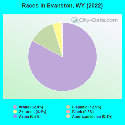
- 9,82982.8%White alone
- 1,48112.5%Hispanic
- 4904.1%Two or more races
- 360.3%Black alone
- 250.2%Asian alone
- 160.1%American Indian alone
Races in Evanston detailed stats: ancestries, foreign born residents, place of birth
According to our research of Wyoming and other state lists, there were 29 registered sex offenders living in Evanston, Wyoming as of April 27, 2024.
The ratio of all residents to sex offenders in Evanston is 422 to 1.
The ratio of registered sex offenders to all residents in this city is lower than the state average.
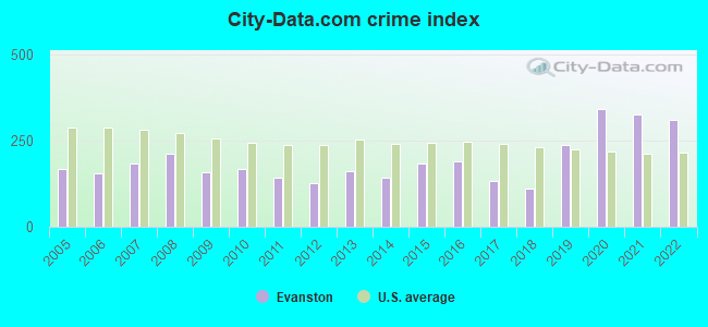
Type |
2009 |
2010 |
2011 |
2012 |
2013 |
2014 |
2015 |
2016 |
2017 |
2018 |
2019 |
2020 |
2021 |
2022 |
|---|---|---|---|---|---|---|---|---|---|---|---|---|---|---|
| Murders (per 100,000) | 0 (0.0) | 0 (0.0) | 0 (0.0) | 0 (0.0) | 0 (0.0) | 0 (0.0) | 0 (0.0) | 2 (16.5) | 0 (0.0) | 0 (0.0) | 0 (0.0) | 0 (0.0) | 0 (0.0) | 0 (0.0) |
| Rapes (per 100,000) | 3 (25.4) | 3 (24.3) | 5 (40.1) | 3 (24.1) | 2 (16.4) | 0 (0.0) | 5 (41.2) | 2 (16.5) | 3 (24.9) | 3 (25.4) | 22 (189.3) | 33 (285.4) | 26 (226.2) | 31 (260.8) |
| Robberies (per 100,000) | 0 (0.0) | 1 (8.1) | 0 (0.0) | 0 (0.0) | 3 (24.5) | 0 (0.0) | 3 (24.7) | 2 (16.5) | 0 (0.0) | 1 (8.5) | 1 (8.6) | 2 (17.3) | 1 (8.7) | 0 (0.0) |
| Assaults (per 100,000) | 8 (67.7) | 3 (24.3) | 7 (56.2) | 2 (16.1) | 2 (16.4) | 9 (73.3) | 7 (57.6) | 9 (74.5) | 13 (107.9) | 7 (59.3) | 7 (60.2) | 13 (112.4) | 19 (165.3) | 16 (134.6) |
| Burglaries (per 100,000) | 29 (245.3) | 30 (242.7) | 25 (200.7) | 30 (240.8) | 26 (212.6) | 21 (171.1) | 22 (181.1) | 24 (198.6) | 29 (240.8) | 11 (93.2) | 22 (189.3) | 26 (224.9) | 56 (487.2) | 28 (235.6) |
| Thefts (per 100,000) | 281 (2,377) | 334 (2,702) | 241 (1,934) | 259 (2,079) | 362 (2,960) | 324 (2,639) | 316 (2,602) | 311 (2,573) | 200 (1,661) | 193 (1,636) | 152 (1,308) | 182 (1,574) | 195 (1,697) | 144 (1,212) |
| Auto thefts (per 100,000) | 19 (160.7) | 23 (186.1) | 11 (88.3) | 6 (48.2) | 8 (65.4) | 15 (122.2) | 23 (189.4) | 12 (99.3) | 14 (116.2) | 8 (67.8) | 9 (77.4) | 11 (95.1) | 11 (95.7) | 14 (117.8) |
| Arson (per 100,000) | 0 (0.0) | 1 (8.1) | 1 (8.0) | 0 (0.0) | 0 (0.0) | 0 (0.0) | 0 (0.0) | 0 (0.0) | 0 (0.0) | 0 (0.0) | 1 (8.6) | 0 (0.0) | 1 (8.7) | 1 (8.4) |
| City-Data.com crime index | 158.9 | 166.7 | 141.8 | 126.3 | 162.3 | 142.0 | 183.8 | 190.9 | 134.1 | 112.1 | 237.8 | 342.3 | 326.3 | 309.9 |
The City-Data.com crime index weighs serious crimes and violent crimes more heavily. Higher means more crime, U.S. average is 246.1. It adjusts for the number of visitors and daily workers commuting into cities.
Crime rate in Evanston detailed stats: murders, rapes, robberies, assaults, burglaries, thefts, arson
Full-time law enforcement employees in 2021, including police officers: 31 (26 officers - 25 male; 1 female).
| Officers per 1,000 residents here: | 2.26 |
| Wyoming average: | 2.78 |
 Recent articles from our blog. Our writers, many of them Ph.D. graduates or candidates, create easy-to-read articles on a wide variety of topics.

 | From Buffalo to Evanston (8 replies) |
| Colorado, Wyoming's Mexico? (46 replies) |
| Evanston for a Summer home.... (7 replies) |
| What can you tell me about Story, WY? & a base camp for research (70 replies) |
| Good Town For Retirees (54 replies) |
| Relocate Wyoming (31 replies) |
Latest news from Evanston, WY collected exclusively by city-data.com from local newspapers, TV, and radio stations
Ancestries: English (23.3%), German (13.3%), American (13.1%), European (3.8%), Welsh (3.1%), Norwegian (2.3%).
Current Local Time: MST time zone
Elevation: 6749 feet
Land area: 10.2 square miles.
Population density: 1,156 people per square mile (low).
318 residents are foreign born (2.1% Latin America, 0.5% Europe).
| This city: | 2.7% |
| Wyoming: | 3.4% |
Median real estate property taxes paid for housing units with mortgages in 2022: $1,316 (0.6%)
Median real estate property taxes paid for housing units with no mortgage in 2022: $1,296 (0.6%)
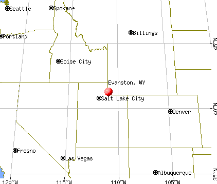
Nearest city with pop. 50,000+: Ogden, UT  (51.9 miles , pop. 77,226).
Nearest city with pop. 200,000+: Northeast Jefferson, CO (325.3 miles , pop. 450,166).
Nearest city with pop. 1,000,000+: Phoenix, AZ (538.5 miles , pop. 1,321,045).
Nearest cities:
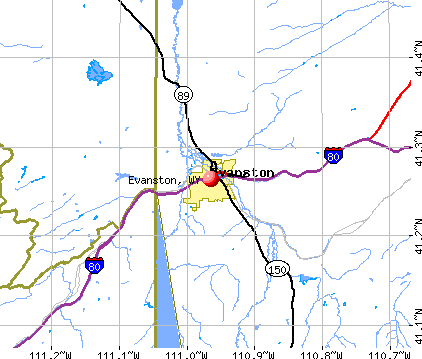
), ), )Latitude: 41.26 N, Longitude: 110.96 W
Daytime population change due to commuting: +331 (+2.8%)
Workers who live and work in this city: 4,605 (79.3%)
Area code: 307

Evanston, Wyoming accommodation & food services, waste management - Economy and Business Data
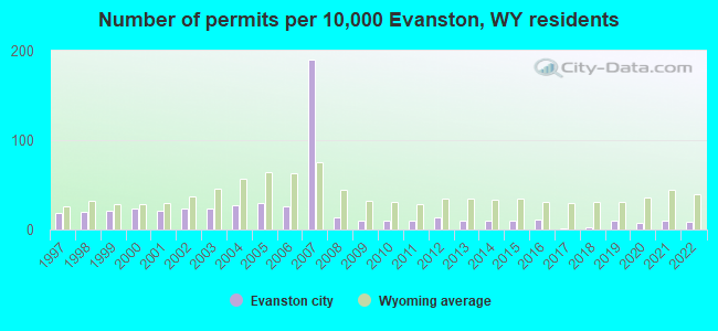
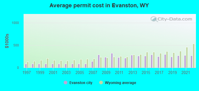
Single-family new house construction building permits:
- 2022: 10 buildings, average cost: $273,300
- 2021: 12 buildings, average cost: $273,700
- 2020: 8 buildings, average cost: $271,600
- 2019: 12 buildings, average cost: $245,300
- 2018: 2 buildings, average cost: $297,500
- 2017: 1 building, cost: $250,000
- 2016: 13 buildings, average cost: $289,000
- 2015: 12 buildings, average cost: $265,600
- 2014: 11 buildings, average cost: $261,100
- 2013: 12 buildings, average cost: $283,200
- 2012: 16 buildings, average cost: $215,800
- 2011: 12 buildings, average cost: $227,700
- 2010: 11 buildings, average cost: $322,600
- 2009: 11 buildings, average cost: $239,700
- 2008: 15 buildings, average cost: $289,200
- 2007: 219 buildings, average cost: $141,400
- 2006: 30 buildings, average cost: $85,500
- 2005: 34 buildings, average cost: $85,500
- 2004: 31 buildings, average cost: $85,500
- 2003: 27 buildings, average cost: $85,500
- 2002: 26 buildings, average cost: $85,500
- 2001: 24 buildings, average cost: $85,500
- 2000: 26 buildings, average cost: $85,500
- 1999: 24 buildings, average cost: $85,500
- 1998: 23 buildings, average cost: $85,500
- 1997: 22 buildings, average cost: $85,500
| Here: | 2.8% |
| Wyoming: | 2.5% |
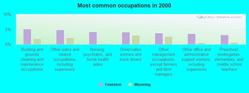
- Building and grounds cleaning and maintenance occupations (5.1%)
- Other sales and related occupations, including supervisors (4.9%)
- Nursing, psychiatric, and home health aides (4.2%)
- Driver/sales workers and truck drivers (4.1%)
- Other management occupations, except farmers and farm managers (3.8%)
- Other office and administrative support workers, including supervisors (3.6%)
- Preschool, kindergarten, elementary, and middle school teachers (3.2%)
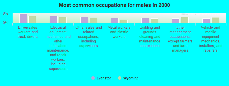
- Driver/sales workers and truck drivers (7.3%)
- Electrical equipment mechanics and other installation, maintenance, and repair workers, including supervisors (5.5%)
- Other sales and related occupations, including supervisors (5.1%)
- Metal workers and plastic workers (3.9%)
- Building and grounds cleaning and maintenance occupations (3.8%)
- Other management occupations, except farmers and farm managers (3.7%)
- Vehicle and mobile equipment mechanics, installers, and repairers (3.7%)
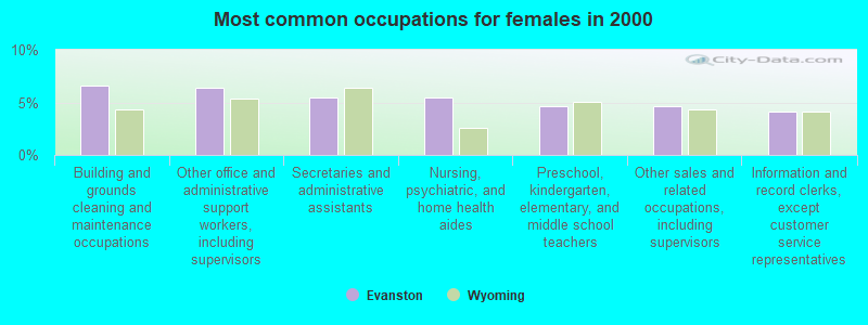
- Building and grounds cleaning and maintenance occupations (6.6%)
- Other office and administrative support workers, including supervisors (6.4%)
- Secretaries and administrative assistants (5.4%)
- Nursing, psychiatric, and home health aides (5.4%)
- Preschool, kindergarten, elementary, and middle school teachers (4.7%)
- Other sales and related occupations, including supervisors (4.6%)
- Information and record clerks, except customer service representatives (4.1%)
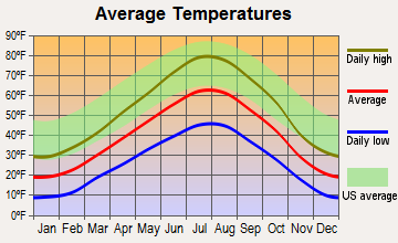
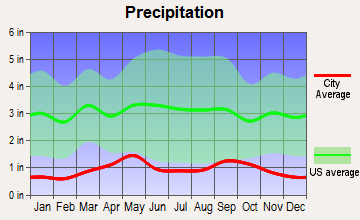
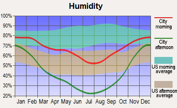
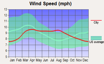
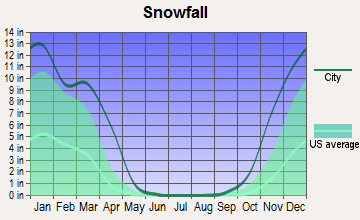
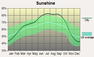
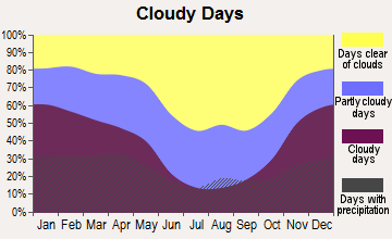
Average climate in Evanston, Wyoming
Based on data reported by over 4,000 weather stations
|
|


(lower is better)
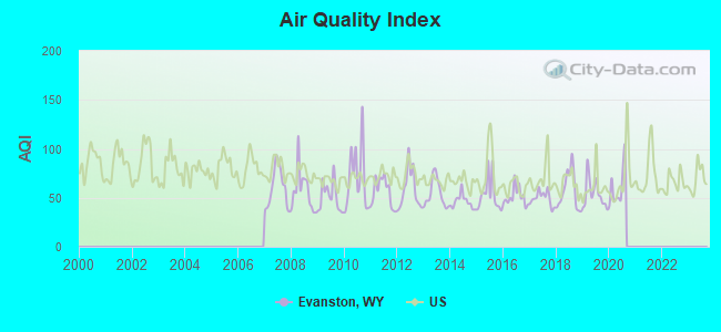
Air Quality Index (AQI) level in 2020 was 60.8. This is about average.
| City: | 60.8 |
| U.S.: | 72.6 |
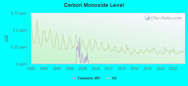
Carbon Monoxide (CO) [ppm] level in 2008 was 0.0654. This is significantly better than average. Closest monitor was 8.6 miles away from the city center.
| City: | 0.0654 |
| U.S.: | 0.2513 |
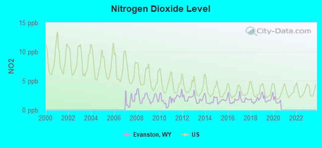
Nitrogen Dioxide (NO2) [ppb] level in 2020 was 1.53. This is significantly better than average. Closest monitor was 8.6 miles away from the city center.
| City: | 1.53 |
| U.S.: | 5.11 |
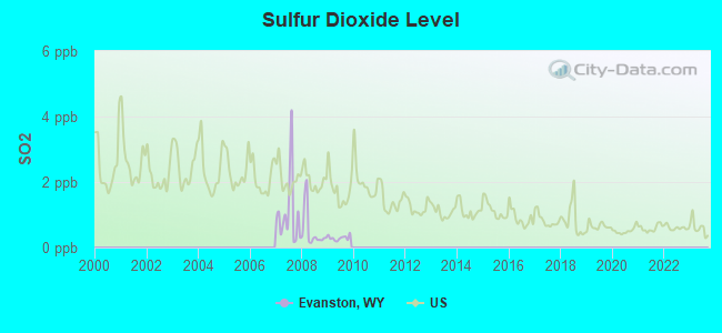
Sulfur Dioxide (SO2) [ppb] level in 2009 was 0.296. This is significantly better than average. Closest monitor was 8.6 miles away from the city center.
| City: | 0.296 |
| U.S.: | 1.515 |
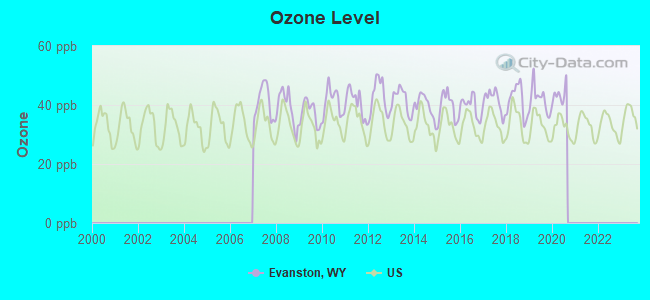
Ozone [ppb] level in 2020 was 43.6. This is worse than average. Closest monitor was 8.6 miles away from the city center.
| City: | 43.6 |
| U.S.: | 33.3 |
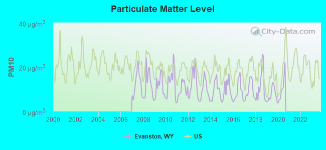
Particulate Matter (PM10) [µg/m3] level in 2020 was 10.3. This is significantly better than average. Closest monitor was 8.6 miles away from the city center.
| City: | 10.3 |
| U.S.: | 19.2 |
Earthquake activity:
Evanston-area historical earthquake activity is significantly above Wyoming state average. It is 1848% greater than the overall U.S. average.On 8/18/1959 at 06:37:13, a magnitude 7.7 (7.7 UK, Class: Major, Intensity: VIII - XII) earthquake occurred 229.0 miles away from the city center, causing $26,000,000 total damage
On 10/28/1983 at 14:06:06, a magnitude 7.3 (6.2 MB, 7.3 MS, 7.0 MW) earthquake occurred 242.2 miles away from the city center, causing 2 deaths (2 shaking deaths) and 3 injuries, causing $15,000,000 total damage
On 10/3/1915 at 06:52:48, a magnitude 7.6 (7.6 UK) earthquake occurred 345.7 miles away from the city center
On 3/28/1975 at 02:31:05, a magnitude 6.2 (6.1 MB, 6.0 MS, 6.2 ML, Class: Strong, Intensity: VII - IX) earthquake occurred 93.7 miles away from the city center
On 3/18/2020 at 13:09:31, a magnitude 5.7 (5.7 MW, Depth: 7.4 mi, Class: Moderate, Intensity: VI - VII) earthquake occurred 68.1 miles away from the city center
On 2/3/1994 at 09:05:04, a magnitude 5.8 (5.4 MB, 5.5 MS, 5.8 MW, 5.8 ML, Depth: 4.9 mi) earthquake occurred 104.7 miles away from Evanston center
Magnitude types: body-wave magnitude (MB), local magnitude (ML), surface-wave magnitude (MS), moment magnitude (MW)
Natural disasters:
The number of natural disasters in Uinta County (3) is a lot smaller than the US average (15).Major Disasters (Presidential) Declared: 1
Emergencies Declared: 1
Causes of natural disasters: Drought: 1, Flood: 1, Landslide: 1, Storm: 1, Other: 1 (Note: some incidents may be assigned to more than one category).
Hospitals and medical centers in Evanston:
- EVANSTON REGIONAL HOSPITAL (Proprietary, provides emergency services, 190 ARROWHEAD DR)
- TENDER HEART HOME CARE/HOSPICE (2661 SOUTH HIGHWAY 150)
- WYOMING STATE HOSPITAL-CAMPBELL HALL (831 S HIGHWAY 150 PO BOX 177)
- RENNIE MEMORIAL NH (1225 UINTA ST)
- ROCKY MOUNTAIN CARE - EVANSTON (475 YELLOW CREEK ROAD)
- EVANSTON REGIONAL HOSPITAL/DIALYSIS (112 YELLOWCREEK RD)
- BEST HOME HEALTH (637 FRONT STREET)
- COMPASSIONATE JOURNEY LLC (86 ALLEGIANCE CIRCLE)
- UINTA HOME HEALTH (1229 UINTA STREET)
Airports and heliports located in Evanston:
- Evanston-Uinta County Burns Field Airport (EVW) (Runways: 1, Air Taxi Ops: 135, Itinerant Ops: 4,300, Local Ops: 1,100, Military Ops: 20)
- Evanston Regional Hospital Heliport (WY52)
Colleges/universities with over 2000 students nearest to Evanston:
- Weber State University (about 52 miles; Ogden, UT; Full-time enrollment: 17,655)
- Utah State University (about 56 miles; Logan, UT; FT enrollment: 21,131)
- University of Utah (about 58 miles; Salt Lake City, UT; FT enrollment: 28,454)
- Westminster College (about 60 miles; Salt Lake City, UT; FT enrollment: 2,870)
- Latter-day Saints Business College (about 60 miles; Salt Lake City, UT; FT enrollment: 2,059)
- Western Governors University (about 62 miles; Salt Lake City, UT; FT enrollment: 31,481)
- Stevens-Henager College-Murray (about 65 miles; Murray, UT; FT enrollment: 6,395)
Public high schools in Evanston:
- EVANSTON HIGH SCHOOL (Students: 835, Location: 701 WEST CHEYENNE DRIVE, Grades: 9-12)
- HORIZON ALTERNATIVE SCHOOL (Students: 46, Location: 164 YELLOWCREEK RD, Grades: 7-12)
Public elementary/middle schools in Evanston:
- UINTA MEADOWS ELEMENTARY (Students: 412, Location: 90 CHEYENNE DRIVE, Grades: KG-5)
- NORTH EVANSTON ELEMENTARY (Students: 361, Location: 500 CEDAR ST, Grades: KG-5)
- DAVIS MIDDLE SCHOOL (Students: 326, Location: 837 NO NAME ST, Grades: 6-8)
- EVANSTON MIDDLE SCHOOL (Students: 314, Location: 341 SUMMIT ST, Grades: 6-8)
- ASPEN ELEMENTARY (Students: 310, Location: 225 BROKEN CIRCLE DRIVE, Grades: KG-5)
- CLARK ELEMENTARY (Students: 195, Location: 1248 MORSE LEE ST, Grades: KG-5)
Points of interest:
Notable locations in Evanston: Uinta County Fire Protection Evanston Station 3 (A), Uinta County Fire Protection Evanston Station 2 (B), Uinta County Fire Protection Evanston Headquarters (C). Display/hide their locations on the map
Shopping Centers: Yellow Creek Shopping Mall (1), Front Street Mall (2), Bear River Mall (3). Display/hide their locations on the map
Cemeteries: Evanston Cemetery (1), City Cemetery (2). Display/hide their locations on the map
Lake: Lake Louise (A). Display/hide its location on the map
Tourist attractions: Uinta County - Museum (36 10th Street), Depot Square (920 Front Street).
Hotels: Days Inn Evanston Wy (1983 Harrison Drive), High Country Inn (1936 Harrison Drive), Economy Inn (1710 Harrison Drive), Legal Tender Restaurant & Lounge (1601 Harrison Drive), Vagabond Motel (230 Bear River Drive), Lamplighter Weston Plaza Hotel (1983 Harrison Drive), Comfort Inn (1931 Harrison Drive), Motel 6 (261 Highway 30 & I-80 East), Pine Gables Inn B&B (1049 Center Street).
Court: District Court (Courthouse).
Birthplace of: Dana Perino - White House Press Secretary, Brady Poppinga - 2005 NFL player (Green Bay Packers, born: Sep 21, 1979), Kirby Heyborne - Actor, Jaycee Carroll - College basketball player (Utah State Aggies), Kris Roberts - Politician.
Drinking water stations with addresses in Evanston and their reported violations in the past:
YELLOW CREEK ESTATES MHP (Population served: 160, Groundwater):Past monitoring violations:UINTA COUNTY YOUTH CAMP (Population served: 100, Groundwater):
- Follow-up Or Routine LCR Tap M/R - In OCT-01-2011, Contaminant: Lead and Copper Rule
Past monitoring violations:CHEVRON CARTER CREEK GAS PLANT (Population served: 80, Surface water):
- 4 routine major monitoring violations
Past health violations:TRAVEL CENTERS OF AMERICA/FT. BRIDGER (Population served: 70, Groundwater):Past monitoring violations:
- Treatment Technique (SWTR and GWR) - In AUG-2012. Follow-up actions: St Violation/Reminder Notice (SEP-11-2012), St Compliance achieved (OCT-11-2012)
- Monthly Turbidity Exceed (Enhanced SWTR) - In AUG-2012, Contaminant: IESWTR. Follow-up actions: St Violation/Reminder Notice (SEP-11-2012), St Compliance achieved (OCT-11-2012)
Past health violations:BEAR RIVER LODGE (Serves UT, Population served: 30, Groundwater):Past monitoring violations:
- MCL, Monthly (TCR) - In DEC-2013, Contaminant: Coliform. Follow-up actions: St Compliance achieved (JAN-15-2014), St Public Notif received (JAN-23-2014), Fed FAO issued (SEP-05-2014)
- MCL, Monthly (TCR) - In NOV-2013, Contaminant: Coliform. Follow-up actions: St Compliance achieved (JAN-15-2014), St Public Notif received (JAN-23-2014), Fed FAO issued (SEP-05-2014)
- One routine major monitoring violation
Past monitoring violations:
- One routine major monitoring violation
Drinking water stations with addresses in Evanston that have no violations reported:
- EVANSTON, CITY OF (Population served: 12,000, Primary Water Source Type: Surface water)
| This city: | 2.7 people |
| Wyoming: | 2.4 people |
| This city: | 69.1% |
| Whole state: | 64.6% |
| This city: | 6.5% |
| Whole state: | 7.1% |
Likely homosexual households (counted as self-reported same-sex unmarried-partner households)
- Lesbian couples: 0.3% of all households
- Gay men: 0.1% of all households
People in group quarters in Evanston in 2010:
- 94 people in group homes intended for adults
- 66 people in mental (psychiatric) hospitals and psychiatric units in other hospitals
- 46 people in workers' group living quarters and job corps centers
- 15 people in nursing facilities/skilled-nursing facilities
- 6 people in in-patient hospice facilities
People in group quarters in Evanston in 2000:
- 110 people in mental (psychiatric) hospitals or wards
- 68 people in nursing homes
- 47 people in other nonhousehold living situations
- 13 people in hospitals or wards for drug/alcohol abuse
- 13 people in other noninstitutional group quarters
- 7 people in schools, hospitals, or wards for the intellectually disabled
Banks with branches in Evanston (2011 data):
- 1ST BANK: Evanston Super Wal-Mart Branch at 125north 2nd Strreet, branch established on 2002/04/17; 1st Bank at 1001 Main Street, branch established on 1934/01/01. Info updated 2011/09/22: Bank assets: $785.6 mil, Deposits: $535.7 mil, local headquarters, negative income in the last year, 10 total offices, Holding Company: Glacier Bancorp, Inc.
- Wells Fargo Bank, National Association: Evanston Branch at 724 Front Street, branch established on 1981/11/16. Info updated 2011/04/05: Bank assets: $1,161,490.0 mil, Deposits: $905,653.0 mil, headquarters in Sioux Falls, SD, positive income, 6395 total offices, Holding Company: Wells Fargo & Company
- Bank of the West: Evanston Branch at 848 Main Street, branch established on 1915/01/01. Info updated 2009/11/16: Bank assets: $62,408.3 mil, Deposits: $43,995.2 mil, headquarters in San Francisco, CA, positive income, 647 total offices, Holding Company: Bnp Paribas
- U.S. Bank National Association: Evanston Branch at 748 Main St, branch established on 1960/09/26. Info updated 2012/01/30: Bank assets: $330,470.8 mil, Deposits: $236,091.5 mil, headquarters in Cincinnati, OH, positive income, 3121 total offices, Holding Company: U.S. Bancorp
- Uinta Bank: Evanston Branch at 120 Yellow Creek Rd, branch established on 2010/10/29. Info updated 2007/10/05: Bank assets: $96.5 mil, Deposits: $83.0 mil, headquarters in Mountain View, WY, positive income, Commercial Lending Specialization, 2 total offices, Holding Company: Ucsb Financial Corporation
For population 15 years and over in Evanston:
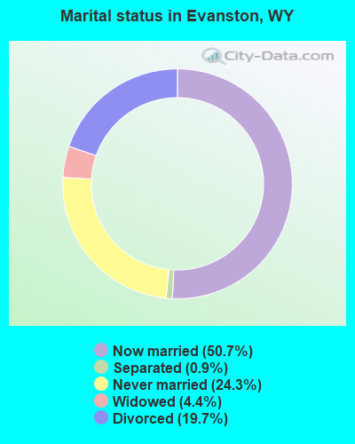
- Never married: 24.3%
- Now married: 50.7%
- Separated: 0.9%
- Widowed: 4.4%
- Divorced: 19.7%
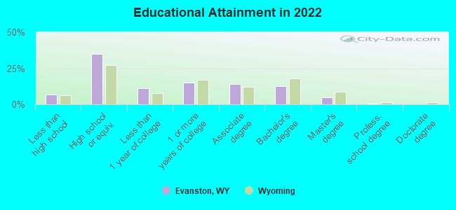
For population 25 years and over in Evanston:
- High school or higher: 93.3%
- Bachelor's degree or higher: 17.6%
- Graduate or professional degree: 5.0%
- Unemployed: 7.4%
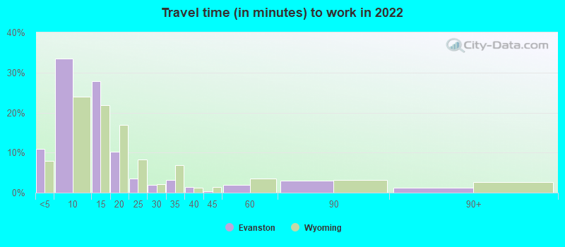
- Mean travel time to work (commute): 17.5 minutes
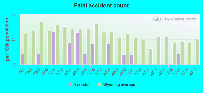
| Here: | 9.3 |
| Wyoming average: | 10.2 |
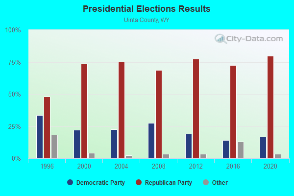
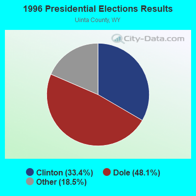
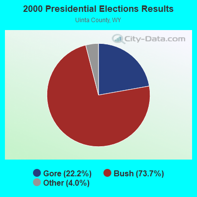
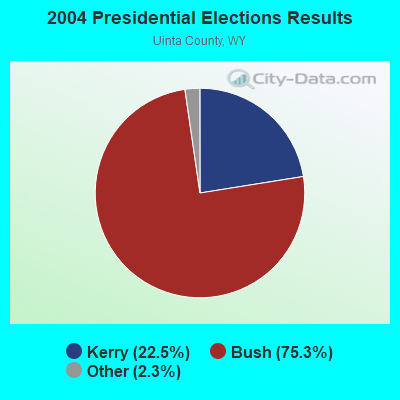
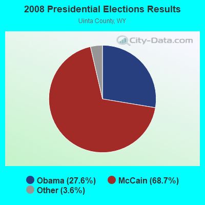
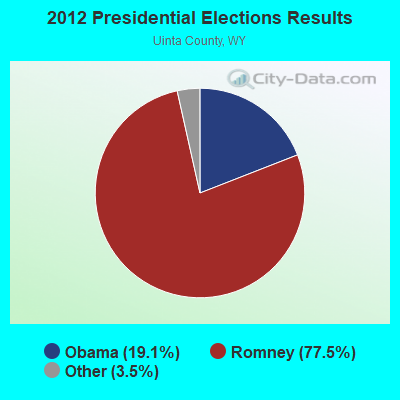
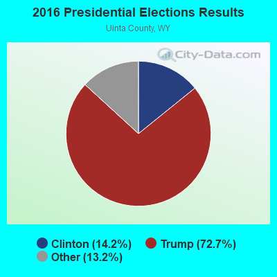
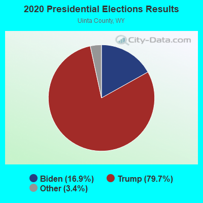
Graphs represent county-level data. Detailed 2008 Election Results
Religion statistics for Evanston, WY (based on Uinta County data)
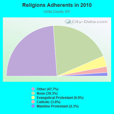
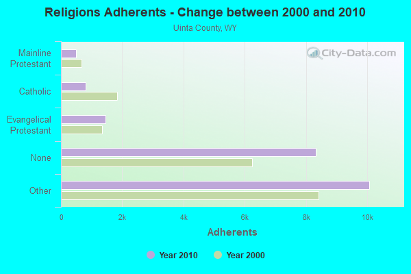
| Religion | Adherents | Congregations |
|---|---|---|
| Other | 10,066 | 23 |
| Evangelical Protestant | 1,450 | 16 |
| Catholic | 803 | 2 |
| Mainline Protestant | 496 | 6 |
| None | 8,303 | - |
Food Environment Statistics:
| This county: | 1.49 / 10,000 pop. |
| Wyoming: | 2.10 / 10,000 pop. |
| This county: | 0.50 / 10,000 pop. |
| State: | 0.27 / 10,000 pop. |
| Uinta County: | 0.99 / 10,000 pop. |
| Wyoming: | 0.65 / 10,000 pop. |
| This county: | 7.44 / 10,000 pop. |
| Wyoming: | 5.36 / 10,000 pop. |
| Uinta County: | 8.43 / 10,000 pop. |
| Wyoming: | 10.08 / 10,000 pop. |
| This county: | 6.4% |
| Wyoming: | 7.1% |
| This county: | 29.6% |
| Wyoming: | 24.4% |
Health and Nutrition:
| Evanston: | 46.8% |
| Wyoming: | 49.4% |
| Evanston: | 42.6% |
| Wyoming: | 46.6% |
| This city: | 29.1 |
| Wyoming: | 28.8 |
| Evanston: | 23.5% |
| State: | 21.3% |
| This city: | 11.6% |
| Wyoming: | 10.2% |
| Evanston: | 6.7 |
| Wyoming: | 6.8 |
| Evanston: | 34.1% |
| Wyoming: | 34.7% |
| Evanston: | 54.5% |
| Wyoming: | 56.6% |
| Evanston: | 78.3% |
| State: | 78.4% |
More about Health and Nutrition of Evanston, WY Residents
| Local government employment and payroll (March 2022) | |||||
| Function | Full-time employees | Monthly full-time payroll | Average yearly full-time wage | Part-time employees | Monthly part-time payroll |
|---|---|---|---|---|---|
| Police Protection - Officers | 25 | $136,090 | $65,323 | 0 | $0 |
| Parks and Recreation | 20 | $85,218 | $51,131 | 65 | $20,096 |
| Other Government Administration | 18 | $47,408 | $31,605 | 0 | $0 |
| Other and Unallocable | 10 | $53,876 | $64,651 | 0 | $0 |
| Water Supply | 9 | $37,811 | $50,415 | 0 | $0 |
| Police - Other | 6 | $26,968 | $53,936 | 1 | $264 |
| Streets and Highways | 6 | $29,598 | $59,196 | 0 | $0 |
| Solid Waste Management | 5 | $23,049 | $55,318 | 0 | $0 |
| Financial Administration | 5 | $24,067 | $57,761 | 0 | $0 |
| Sewerage | 4 | $19,902 | $59,706 | 0 | $0 |
| Judicial and Legal | 1 | $4,958 | $59,496 | 0 | $0 |
| Totals for Government | 109 | $488,944 | $53,829 | 66 | $20,360 |
Evanston government finances - Expenditure in 2021 (per resident):
- Construction - Water Utilities: $578,000 ($48.80)
Regular Highways: $500,000 ($42.21)
Sewerage: $379,000 ($32.00)
Solid Waste Management: $284,000 ($23.98)
Parks and Recreation: $149,000 ($12.58)
General - Other: $98,000 ($8.27)
General Public Buildings: $24,000 ($2.03)
Miscellaneous Commercial Activities - Other: $16,000 ($1.35)
- Current Operations - Parks and Recreation: $5,226,000 ($441.20)
Police Protection: $3,014,000 ($254.45)
Water Utilities: $1,848,000 ($156.02)
Solid Waste Management: $1,154,000 ($97.43)
General - Other: $1,153,000 ($97.34)
General Public Buildings: $972,000 ($82.06)
Sewerage: $947,000 ($79.95)
Regular Highways: $884,000 ($74.63)
Financial Administration: $606,000 ($51.16)
Central Staff Services: $418,000 ($35.29)
Health - Other: $402,000 ($33.94)
Correctional Institutions: $287,000 ($24.23)
Judicial and Legal Services: $270,000 ($22.79)
Local Fire Protection: $223,000 ($18.83)
Miscellaneous Commercial Activities - Other: $207,000 ($17.48)
Housing and Community Development: $129,000 ($10.89)
Air Transportation: $75,000 ($6.33)
- Other Capital Outlay - Water Utilities: $430,000 ($36.30)
General - Other: $306,000 ($25.83)
Parks and Recreation: $266,000 ($22.46)
Solid Waste Management: $140,000 ($11.82)
Police Protection: $119,000 ($10.05)
General Public Building: $38,000 ($3.21)
Financial Administration: $24,000 ($2.03)
Regular Highways: $9,000 ($0.76)
Miscellaneous Commercial Activities - Other: $7,000 ($0.59)
Judicial and Legal Services: $5,000 ($0.42)
Sewerage: $1,000 ($0.08)
Evanston government finances - Revenue in 2021 (per resident):
- Charges - Solid Waste Management: $1,462,000 ($123.43)
Sewerage: $1,264,000 ($106.71)
Parks and Recreation: $1,028,000 ($86.79)
Other: $75,000 ($6.33)
Miscellaneous Commercial Activities: $47,000 ($3.97)
- Federal Intergovernmental - Other: $2,021,000 ($170.62)
- Local Intergovernmental - General Local Government Support: $2,544,000 ($214.77)
Other: $55,000 ($4.64)
- Miscellaneous - Interest Earnings: $249,000 ($21.02)
Fines and Forfeits: $188,000 ($15.87)
General Revenue - Other: $171,000 ($14.44)
Sale of Property: $145,000 ($12.24)
- Revenue - Water Utilities: $2,696,000 ($227.61)
- State Intergovernmental - Other: $4,832,000 ($407.94)
General Local Government Support: $4,166,000 ($351.71)
Highways: $540,000 ($45.59)
Health and Hospitals: $22,000 ($1.86)
- Tax - Property: $1,278,000 ($107.89)
Other Selective Sales: $236,000 ($19.92)
Public Utilities Sales: $168,000 ($14.18)
Other: $144,000 ($12.16)
Other License: $100,000 ($8.44)
Occupation and Business License - Other: $91,000 ($7.68)
Evanston government finances - Cash and Securities in 2021 (per resident):
- Other Funds - Cash and Securities: $54,265,000 ($4581.26)
| Businesses in Evanston, WY | ||||
| Name | Count | Name | Count | |
|---|---|---|---|---|
| Ace Hardware | 1 | KFC | 1 | |
| Arby's | 1 | Kroger | 2 | |
| AutoZone | 1 | La-Z-Boy | 1 | |
| Best Western | 1 | Lane Furniture | 1 | |
| Big O Tires | 1 | MasterBrand Cabinets | 3 | |
| Chevrolet | 1 | Maurices | 1 | |
| Comfort Inn | 1 | McDonald's | 1 | |
| Curves | 1 | Motel 6 | 1 | |
| Days Inn | 1 | Penske | 1 | |
| Domino's Pizza | 1 | Pizza Hut | 1 | |
| Econo Lodge | 1 | Super 8 | 1 | |
| FedEx | 4 | U-Haul | 1 | |
| H&R Block | 1 | UPS | 7 | |
| Hilton | 1 | Walmart | 1 | |
| Holiday Inn | 1 | Wendy's | 1 | |
| Howard Johnson | 1 | |||
Strongest AM radio stations in Evanston:
- KEVA (1240 AM; 1 kW; EVANSTON, WY; Owner: SAGEBRUSH BROADCASTING COMPANY, INC.)
- KALL (700 AM; 50 kW; NORTH SALT LAKE CITY, UT; Owner: CITICASTERS LICENSES, L.P.)
- KIQN (1010 AM; 50 kW; TOOELE, UT)
- KSL (1160 AM; 50 kW; SALT LAKE CITY, UT; Owner: BONNEVILLE HOLDING COMPANY)
- KTKK (630 AM; 10 kW; SANDY, UT; Owner: UNITED BROADCASTING COMPANY)
- KSOS (800 AM; 10 kW; BRIGHAM CITY, UT; Owner: SIMMONS-SLC, LS, LLC)
- KBEE (860 AM; 10 kW; SALT LAKE CITY, UT; Owner: CITADEL BROADCASTING COMPANY)
- KMER (950 AM; 5 kW; KEMMERER, WY; Owner: CHAPARRAL BROADCASTING, INC.)
- KANN (1120 AM; 10 kW; ROY, UT; Owner: FAITH COMMUNICATIONS CORPORATION)
- KNRS (570 AM; 5 kW; SALT LAKE CITY, UT; Owner: CITICASTERS LICENSES, L.P.)
- KZNS (1280 AM; 10 kW; SALT LAKE CITY, UT; Owner: SIMMONS-SLC, LS, LLC)
- KVNU (610 AM; 5 kW; LOGAN, UT; Owner: SUN VALLEY RADIO,INC.)
- KLO (1430 AM; 10 kW; OGDEN, UT; Owner: KLO BROADCASTING CO.)
Strongest FM radio stations in Evanston:
- KOTB (106.1 FM; EVANSTON, WY; Owner: ROCKY MOUNTAIN RADIO NETWORK, INC.)
- KNYN (99.1 FM; FORT BRIDGER, WY; Owner: M. KENT FRANDSEN)
- K209DC (89.7 FM; EVANSTON, WY; Owner: CALVARY CHAPEL OF TWIN FALLS, INC.)
- K240CP (95.9 FM; EVANSTON, WY; Owner: WESTERN INSPIRATIONAL BROADCASTERS, INC)
- KWKD (102.3 FM; RANDOLPH, UT; Owner: MILLCREEK BROADCASTING, L.L.C.)
- KCUA (92.5 FM; COALVILLE, UT; Owner: COMMUNITY WIRELESS OF PARK CITY, INC)
- KBZN-FM1 (97.9 FM; PARK CITY, UT; Owner: CAPITOL BROADCASTING INC.)
- K201AE (88.1 FM; COALVILLE, ETC., UT; Owner: COMMUNITY WIRELESS OF PARK CITY, INC)
- KZHT-FM1 (94.9 FM; PARK CITY, UT; Owner: CITICASTERS LICENSES, L.P.)
- KCPX (105.7 FM; CENTERVILLE, UT; Owner: MERCURY BROADCASTING COMPANY, INC.)
- KSOP-FM (104.3 FM; SALT LAKE CITY, UT; Owner: KSOP, INC.)
- K272DP (102.3 FM; TOOELE, UT; Owner: FAMILY STATIONS, INC.)
- KPCW (91.9 FM; PARK CITY, UT; Owner: COMMUNITY WIRELESS OF PARK CITY, INC.)
- KBZN (97.9 FM; OGDEN, UT; Owner: CAPITOL BROADCASTING, INC.)
- KRCL (90.9 FM; SALT LAKE CITY, UT; Owner: LISTENERS COMMUNITY RADIO OF UTAH)
- KBER (101.1 FM; OGDEN, UT; Owner: CITADEL BROADCASTING COMPANY)
- KISN-FM (97.1 FM; SALT LAKE CITY, UT; Owner: CLEAR CHANNEL BROADCASTING LICENSES, INC.)
- KKAT (101.9 FM; OGDEN, UT; Owner: CITICASTERS LICENSES, L.P.)
- KSFI (100.3 FM; SALT LAKE CITY, UT; Owner: SIMMONS-SLC, LS, LLC)
- KUBL-FM (93.3 FM; SALT LAKE CITY, UT; Owner: CITADEL BROADCASTING COMPANY)
TV broadcast stations around Evanston:
- K23DS (Channel 23; EVANSTON, WY; Owner: WYOMING COMMUNICATIONS CORPORATION)
- K25EE (Channel 25; MOUNTAIN VIEW, ETC., UT; Owner: DAGGETT COUNTY TELEVISION DEPT.)
- K59BV (Channel 59; LAVA HOT SPRINGS, ID; Owner: STATE BOARD OF EDUCATION (IEPBS))
- K28DV (Channel 28; EVANSTON, WY; Owner: ACME TELEVISION LICENSES OF UTAH, LLC)
- K32DS (Channel 32; EVANSTON, WY; Owner: WYOMING COMMUNICATIONS CORPORATION)
- K09JL (Channel 9; UPPER BEAR VALLEY, E, WY; Owner: UPPER BEAR RIVER TV SERVICE)
- K11JQ (Channel 11; UPPER BEAR VALLEY, E, WY; Owner: UPPER BEAR RIVER TV SERVICE)
- K19CP (Channel 19; MOUNTAIN VIEW, WY; Owner: LARRY H. MILLER COMMUNICATIONS CORP.)
- K08HB (Channel 8; CARTER, WY; Owner: UPPER BEAR RIVER TV SERVICE)
- K10HR (Channel 10; CARTER, WY; Owner: UPPER BEAR RIVER TV SERVICE)
- K12ID (Channel 12; CARTER, WY; Owner: UPPER BEAR RIVER TV SERVICE)
- K13JV (Channel 13; UPPER BEAR VALLEY, E, WY; Owner: UPPER BEAR RIVER T.V. SERVICE)
- K15FR (Channel 15; EVANSTON, ETC., WY; Owner: UNIVERSITY OF UTAH)
- National Bridge Inventory (NBI) Statistics
- 24Number of bridges
- 358ft / 109mTotal length
- $6,591,000Total costs
- 149,709Total average daily traffic
- 38,923Total average daily truck traffic
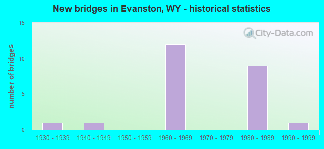
- New bridges - historical statistics
- 11930-1939
- 11940-1949
- 121960-1969
- 91980-1989
- 11990-1999
FCC Registered Antenna Towers: 57 (See the full list of FCC Registered Antenna Towers)
FCC Registered Commercial Land Mobile Towers: 2 (See the full list of FCC Registered Commercial Land Mobile Towers in Evanston, WY)
FCC Registered Private Land Mobile Towers: 3 (See the full list of FCC Registered Private Land Mobile Towers)
FCC Registered Broadcast Land Mobile Towers: 54 (See the full list of FCC Registered Broadcast Land Mobile Towers)
FCC Registered Microwave Towers: 129 (See the full list of FCC Registered Microwave Towers in this town)
FCC Registered Paging Towers: 5 (See the full list of FCC Registered Paging Towers)
FCC Registered Maritime Coast & Aviation Ground Towers: 5 (See the full list of FCC Registered Maritime Coast & Aviation Ground Towers)
FCC Registered Amateur Radio Licenses: 78 (See the full list of FCC Registered Amateur Radio Licenses in Evanston)
FAA Registered Aircraft: 19 (See the full list of FAA Registered Aircraft in Evanston)
2002 - 2018 National Fire Incident Reporting System (NFIRS) incidents
- Fire incident types reported to NFIRS in Evanston, WY
- 37048.9%Outside Fires
- 21628.6%Structure Fires
- 15820.9%Mobile Property/Vehicle Fires
- 121.6%Other
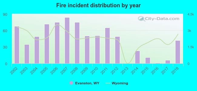 Based on the data from the years 2002 - 2018 the average number of fires per year is 44. The highest number of reported fires - 84 took place in 2007, and the least - 0 in 2013. The data has a decreasing trend.
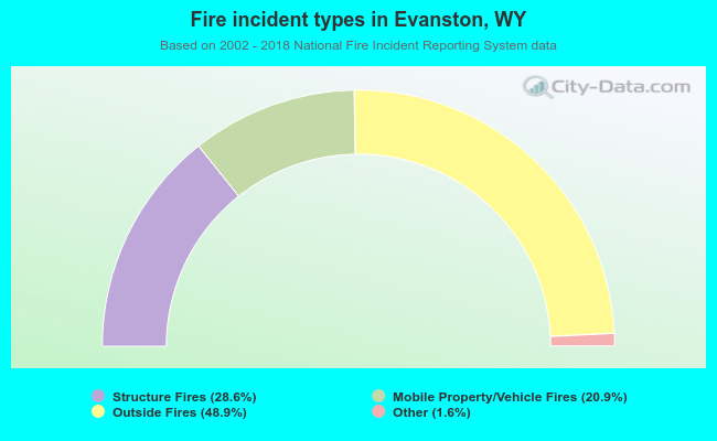 When looking into fire subcategories, the most reports belonged to: Outside Fires (48.9%), and Structure Fires (28.6%).
Fire-safe hotels and motels in Evanston, Wyoming:
- Evanston Inn, 247 Bear Riv Dr, Evanston, Wyoming 82930 , Phone: (307) 789-2612
- Econo Lodge, 70 Bear Riv Dr, Evanston, Wyoming 82930 , Phone: (307) 789-7510, Fax: (307) 789-8332
- Whirl Inn Motel, 1724 Harrison Dr, Evanston, Wyoming 82930 , Phone: (307) 789-9610
- Weston Plaza Hotel, 1983 Harrison Dr, Evanston, Wyoming 82930 , Phone: (307) 789-0783, Fax: (307) 789-7186
- Economy Inn, 1710 Harrison Dr, Evanston, Wyoming 82930 , Phone: (307) 789-2777, Fax: (307) 789-7211
- Comfort Inn, 1931 Harrison Dr, Evanston, Wyoming 82930 , Phone: (307) 789-7799, Fax: (307) 789-7733
- Holiday Inn Express Hotel & Suites, 1965 Harrison Dr, Evanston, Wyoming 82930 , Phone: (307) 789-7999, Fax: (307) 789-6999
- Howard Johnson, 339 Wasatch Rd, Evanston, Wyoming 82930 , Phone: (307) 789-2220, Fax: (307) 789-4122
- Hampton Inn, 101 Wasatch Dr, Evanston, Wyoming 82930 , Phone: (307) 789-5678, Fax: (307) 789-6600
| Most common first names in Evanston, WY among deceased individuals | ||
| Name | Count | Lived (average) |
|---|---|---|
| John | 49 | 74.9 years |
| William | 46 | 77.2 years |
| James | 38 | 69.5 years |
| Mary | 32 | 82.3 years |
| Robert | 28 | 70.9 years |
| George | 25 | 72.1 years |
| David | 23 | 62.7 years |
| Joseph | 22 | 76.2 years |
| Charles | 20 | 69.0 years |
| Dorothy | 20 | 75.2 years |
| Most common last names in Evanston, WY among deceased individuals | ||
| Last name | Count | Lived (average) |
|---|---|---|
| Smith | 32 | 72.0 years |
| Williams | 15 | 68.5 years |
| Hutchinson | 15 | 71.3 years |
| Martin | 14 | 76.6 years |
| Cook | 14 | 79.7 years |
| Sims | 13 | 78.6 years |
| Miller | 13 | 74.7 years |
| Brown | 12 | 83.0 years |
| Davis | 12 | 74.1 years |
| Lester | 12 | 69.6 years |
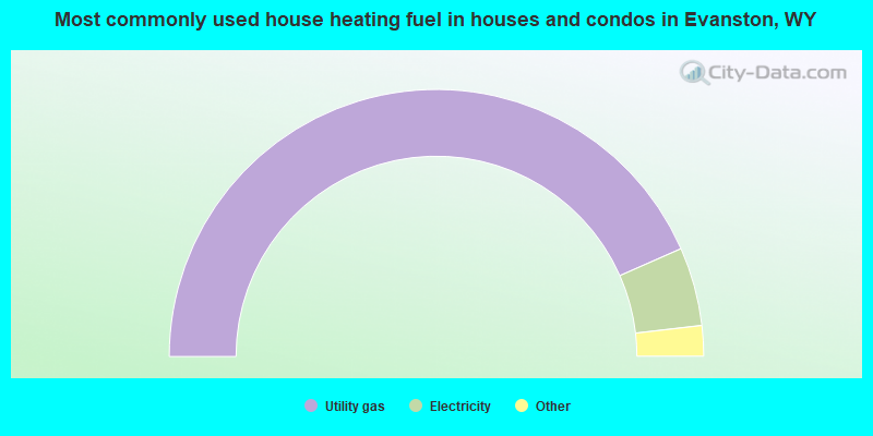
- 86.8%Utility gas
- 9.5%Electricity
- 2.3%Bottled, tank, or LP gas
- 0.7%Wood
- 0.5%Solar energy
- 0.2%No fuel used
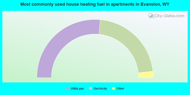
- 53.0%Utility gas
- 43.6%Electricity
- 1.6%Other fuel
- 1.2%Solar energy
- 0.5%No fuel used
Evanston compared to Wyoming state average:
- Unemployed percentage below state average.
- Black race population percentage below state average.
- Median age significantly below state average.
- Length of stay since moving in significantly above state average.
- House age significantly below state average.
Evanston on our top lists:
- #31 on the list of "Top 101 cities with the most local government spending on current operations of parks and recreation per resident (population 10,000+)"
- #34 on the list of "Top 100 highest located cities (pop. 5,000+)"
- #44 on the list of "Top 101 cities with the most full-time park and recreation workers per 1000 residents (population 5,000+)"
- #71 on the list of "Top 101 cities with the largest percentage of people in mental (psychiatric) hospitals or wards (population 1,000+)"
- #95 on the list of "Top 101 cities with largest percentage of males in occupations: healthcare support occupations (population 5,000+)"
- #1 on the list of "Top 101 counties with the lowest Nitrogen Dioxide air pollution readings in 2012 (ppm)"
- #22 on the list of "Top 101 counties with the highest Ozone (1-hour) air pollution readings in 2012 (ppm)"
- #47 on the list of "Top 101 counties with the lowest Particulate Matter (PM10) Annual air pollution readings in 2012 (µg/m3)"

|
|
Total of 16 patent applications in 2008-2024.