Fort Gibson, Oklahoma
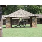
Fort Gibson: Fort Gibson
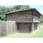
Fort Gibson: Fort Gibson
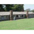
Fort Gibson: Fort Gibson

Fort Gibson: Ft. Gibson Dam and Lake
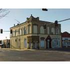
Fort Gibson: The Corner Drug Store
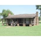
Fort Gibson: Fort Gibson
- add
your
Submit your own pictures of this town and show them to the world
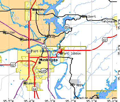
- OSM Map
- General Map
- Google Map
- MSN Map
Population change since 2000: -6.0%
 |
| Males: 1,764 | |
| Females: 2,046 |
| Median resident age: | 38.1 years |
| Oklahoma median age: | 37.1 years |
Zip codes: 74434.
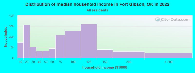
| Fort Gibson: | $72,912 |
| OK: | $59,673 |
Estimated per capita income in 2022: $31,237 (it was $14,042 in 2000)
Fort Gibson town income, earnings, and wages data
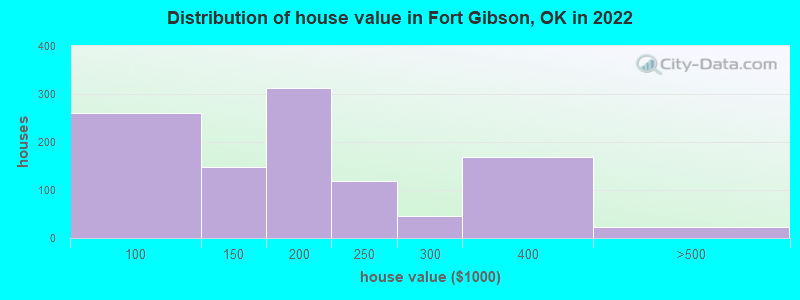
Estimated median house or condo value in 2022: $179,281 (it was $68,500 in 2000)
| Fort Gibson: | $179,281 |
| OK: | $191,700 |
Mean prices in 2022: all housing units: $198,986; detached houses: $209,870; mobile homes: $67,800
Median gross rent in 2022: $718.
(8.8% for White Non-Hispanic residents, 100.0% for Black residents, 28.9% for Hispanic or Latino residents, 4.2% for American Indian residents, 100.0% for other race residents, 20.7% for two or more races residents)
Detailed information about poverty and poor residents in Fort Gibson, OK
Compare current foreclosures near Fort Gibson, OK:
| Photo | Address | Area | Beds / Baths | Price | Details |
|---|---|---|---|---|---|

|
#1
Bowden Pl
Fort Gibson, OK 74434
|
1,591 sq. feet
|
2 baths 3 beds |
$233,500
|
show details |

|
#2
Leaning Tree Rd
Fort Gibson, OK 74434
|
1,316 sq. feet
|
1 baths 3 beds |
show details | |

|
#3
S Lee St
Fort Gibson, OK 74434
|
- sq. feet
|
- baths - beds |
show details | |

|
#4
W 805 Rd
Fort Gibson, OK 74434
|
- sq. feet
|
- baths - beds |
show details | |

|
#5
W Stick Ross Mountain Cir
Tahlequah, OK 74464
|
1,500 sq. feet
|
1 baths 4 beds |
$212,000
|
show details |

|
#6
S Cherokee St
Muskogee, OK 74403
|
2,176 sq. feet
|
1 baths 3 beds |
$325,000
|
show details |

|
#7
N 62nd St E
Fort Gibson, OK 74434
|
- sq. feet
|
- baths - beds |
show details | |

|
#8
S Monroe Ave
Wagoner, OK 74467
|
1,161 sq. feet
|
2 baths 3 beds |
show details | |

|
#9
E 107th St N
Wagoner, OK 74467
|
1,716 sq. feet
|
2 baths 3 beds |
show details | |

|
#10
S Starlite Dr
Hulbert, OK 74441
|
1,562 sq. feet
|
1 baths 3 beds |
show details |
| Photo | Address | Area | Beds / Baths | Price | Details |
|---|---|---|---|---|---|

|
#11
NE 2nd St
Wagoner, OK 74467
|
1,508 sq. feet
|
2 baths 3 beds |
show details | |

|
#12
Fredonia St
Muskogee, OK 74403
|
912 sq. feet
|
1 baths 2 beds |
show details | |

|
#13
N Parkinson Ave
Wagoner, OK 74467
|
1,624 sq. feet
|
1 baths 2 beds |
show details | |

|
#14
W Okmulgee St
Muskogee, OK 74401
|
2,644 sq. feet
|
2 baths 3 beds |
show details | |

|
#15
Highway 62
Tahlequah, OK 74464
|
1,683 sq. feet
|
1 baths 3 beds |
show details | |

|
#16
Kendall Blvd
Muskogee, OK 74401
|
48 sq. feet
|
2 baths 3 beds |
show details | |

|
#17
E 6th St
Hulbert, OK 74441
|
1,540 sq. feet
|
2 baths 3 beds |
show details | |

|
#18
W Main St
Hulbert, OK 74441
|
1,216 sq. feet
|
2 baths 3 beds |
show details | |

|
#19
Crestwood Dr
Wagoner, OK 74467
|
1,107 sq. feet
|
1 baths 3 beds |
show details | |

|
#20
Elwell Rd
Muskogee, OK 74401
|
978 sq. feet
|
1 baths 3 beds |
show details |
| Photo | Address | Area | Beds / Baths | Price | Details |
|---|---|---|---|---|---|

|
#21
W Clyde Maher Rd
Tahlequah, OK 74464
|
1,020 sq. feet
|
1 baths 2 beds |
show details | |

|
#22
S 26th St
Muskogee, OK 74401
|
1,596 sq. feet
|
2 baths 3 beds |
show details | |

|
#23
Highland Dr
Tahlequah, OK 74464
|
1,910 sq. feet
|
2 baths 3 beds |
show details | |

|
#24
Fondulac St
Muskogee, OK 74401
|
1,923 sq. feet
|
2 baths 3 beds |
show details | |

|
#25
W Golf Course Rd
Tahlequah, OK 74464
|
1,953 sq. feet
|
2 baths 4 beds |
show details | |

|
#26
Palmer Dr
Muskogee, OK 74401
|
1,191 sq. feet
|
1 baths 2 beds |
show details | |

|
#27
Quail Run
Muskogee, OK 74403
|
1,292 sq. feet
|
2 baths 3 beds |
show details | |

|
#28
S 29th St
Muskogee, OK 74401
|
1,456 sq. feet
|
1 baths 3 beds |
show details | |

|
#29
Hillcrest Ave
Tahlequah, OK 74464
|
1,700 sq. feet
|
1 baths 3 beds |
show details | |

|
#30
S 3rd St
Muskogee, OK 74401
|
1,200 sq. feet
|
2 baths 3 beds |
show details |
| Photo | Address | Area | Beds / Baths | Price | Details |
|---|---|---|---|---|---|

|
#31
Cherry St
Muskogee, OK 74403
|
1,007 sq. feet
|
1 baths 2 beds |
show details | |

|
#32
E 18th St S
Muskogee, OK 74403
|
1,456 sq. feet
|
1 baths 3 beds |
show details | |

|
#33
Bacon Rd
Muskogee, OK 74403
|
2,581 sq. feet
|
2 baths 3 beds |
show details | |

|
#34
Sarah Ln
Muskogee, OK 74403
|
1,340 sq. feet
|
1 baths 3 beds |
show details | |

|
#35
S 65th St E
Muskogee, OK 74403
|
1,471 sq. feet
|
1 baths 2 beds |
show details | |

|
#36
N David Ln
Muskogee, OK 74403
|
1,680 sq. feet
|
2 baths 2 beds |
show details | |

|
#37
S 41st St E
Muskogee, OK 74403
|
1,439 sq. feet
|
2 baths 3 beds |
show details | |

|
#38
Bel Aire Pl
Muskogee, OK 74403
|
1,998 sq. feet
|
2 baths 3 beds |
show details | |

|
#39
Irving St
Muskogee, OK 74403
|
972 sq. feet
|
1 baths 2 beds |
show details | |

|
#40
Wood St
Muskogee, OK 74403
|
546 sq. feet
|
1 baths 2 beds |
show details |
| Photo | Address | Area | Beds / Baths | Price | Details |
|---|---|---|---|---|---|

|
#41
Tull Pl
Muskogee, OK 74403
|
1,328 sq. feet
|
2 baths 3 beds |
show details | |

|
#42
N T St
Muskogee, OK 74403
|
1,956 sq. feet
|
2 baths 3 beds |
show details | |

|
#43
S 319 Rd
Wagoner, OK 74467
|
1,868 sq. feet
|
2 baths - beds |
show details | |

|
#44
NW 16th St
Wagoner, OK 74467
|
1,485 sq. feet
|
2 baths - beds |
show details | |

|
#45
NE 5th St
Wagoner, OK 74467
|
1,190 sq. feet
|
1 baths - beds |
show details | |

|
#46
E Cherokee St
Wagoner, OK 74467
|
1,260 sq. feet
|
1 baths - beds |
show details | |

|
#47
S Camden St
Muskogee, OK 74403
|
- sq. feet
|
- baths - beds |
show details | |

|
#48
Jefferson Ct
Muskogee, OK 74403
|
- sq. feet
|
- baths - beds |
show details | |

|
#49
Camelot Dr # A
Tahlequah, OK 74464
|
- sq. feet
|
- baths - beds |
show details | |

|
Check over 1 million property listings on Foreclosure.com!
|
browse all offers | |||


- 2,05354.1%White alone
- 91624.1%American Indian alone
- 49913.1%Two or more races
- 2827.4%Hispanic
- 280.7%Black alone
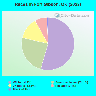
Races in Fort Gibson detailed stats: ancestries, foreign born residents, place of birth
According to our research of Oklahoma and other state lists, there were 16 registered sex offenders living in Fort Gibson, Oklahoma as of April 28, 2024.
The ratio of all residents to sex offenders in Fort Gibson is 255 to 1.
Type |
2009 |
2010 |
2011 |
2012 |
2013 |
2014 |
2015 |
2016 |
2017 |
2018 |
2019 |
2020 |
2021 |
2022 |
|---|---|---|---|---|---|---|---|---|---|---|---|---|---|---|
| Murders (per 100,000) | 0 (0.0) | 0 (0.0) | 0 (0.0) | 0 (0.0) | 0 (0.0) | 0 (0.0) | 0 (0.0) | 0 (0.0) | 0 (0.0) | 0 (0.0) | 0 (0.0) | 0 (0.0) | 1 (25.6) | 0 (0.0) |
| Rapes (per 100,000) | 2 (45.4) | 2 (48.1) | 0 (0.0) | 0 (0.0) | 3 (72.8) | 0 (0.0) | 0 (0.0) | 0 (0.0) | 2 (49.4) | 1 (24.9) | 3 (75.5) | 3 (76.2) | 1 (25.6) | 1 (26.2) |
| Robberies (per 100,000) | 0 (0.0) | 1 (24.1) | 0 (0.0) | 0 (0.0) | 0 (0.0) | 0 (0.0) | 0 (0.0) | 1 (24.6) | 1 (24.7) | 0 (0.0) | 1 (25.2) | 0 (0.0) | 0 (0.0) | 0 (0.0) |
| Assaults (per 100,000) | 5 (113.5) | 4 (96.3) | 2 (47.6) | 3 (71.8) | 1 (24.3) | 19 (461.7) | 7 (171.1) | 8 (196.7) | 10 (247.2) | 6 (149.2) | 9 (226.6) | 18 (457.3) | 13 (332.3) | 7 (183.3) |
| Burglaries (per 100,000) | 34 (772.0) | 22 (529.6) | 24 (571.7) | 31 (741.4) | 17 (412.3) | 15 (364.5) | 23 (562.3) | 24 (590.0) | 38 (939.4) | 10 (248.7) | 7 (176.2) | 10 (254.1) | 13 (332.3) | 8 (209.5) |
| Thefts (per 100,000) | 54 (1,226) | 50 (1,204) | 53 (1,263) | 59 (1,411) | 38 (921.7) | 24 (583.2) | 23 (562.3) | 16 (393.3) | 34 (840.5) | 35 (870.4) | 19 (478.3) | 29 (736.8) | 37 (945.8) | 36 (942.9) |
| Auto thefts (per 100,000) | 9 (204.4) | 5 (120.4) | 2 (47.6) | 2 (47.8) | 7 (169.8) | 2 (48.6) | 1 (24.4) | 6 (147.5) | 5 (123.6) | 4 (99.5) | 3 (75.5) | 1 (25.4) | 2 (51.1) | 4 (104.8) |
| Arson (per 100,000) | 0 (0.0) | 2 (48.1) | 0 (0.0) | 0 (0.0) | 0 (0.0) | 0 (0.0) | 0 (0.0) | 0 (0.0) | 2 (49.4) | 0 (0.0) | 0 (0.0) | 0 (0.0) | 1 (25.6) | 0 (0.0) |
| City-Data.com crime index | 178.5 | 159.8 | 103.9 | 126.5 | 142.4 | 145.1 | 98.0 | 115.5 | 205.7 | 109.9 | 150.8 | 201.7 | 203.2 | 118.4 |
The City-Data.com crime index weighs serious crimes and violent crimes more heavily. Higher means more crime, U.S. average is 246.1. It adjusts for the number of visitors and daily workers commuting into cities.
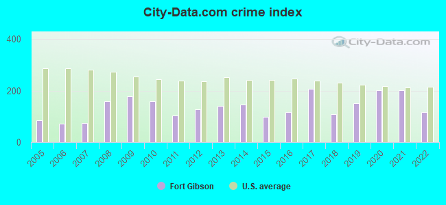
Crime rate in Fort Gibson detailed stats: murders, rapes, robberies, assaults, burglaries, thefts, arson
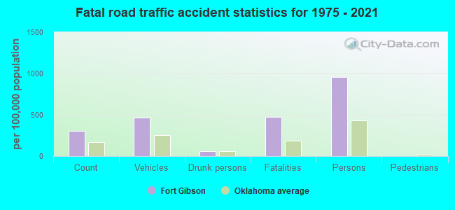
Full-time law enforcement employees in 2021, including police officers: 14 (13 officers - 11 male; 2 female).
| Officers per 1,000 residents here: | 3.32 |
| Oklahoma average: | 2.27 |
 Recent articles from our blog. Our writers, many of them Ph.D. graduates or candidates, create easy-to-read articles on a wide variety of topics.

 | Where to live near Muskogee?? (2 replies) |
| How do I make friends in Tulsa? (88 replies) |
| Is the any Justice? (Fort Gibson, OK) (10 replies) |
| Thinking on making Oklahoma our final destination to live, need input please! (43 replies) |
| Brother (33, single, CPA) moving to Bartlesville, OK from L.A. (62 replies) |
| Fort Gibson OK (9 replies) |
Latest news from Fort Gibson, OK collected exclusively by city-data.com from local newspapers, TV, and radio stations
Ancestries: American (13.7%), Irish (9.6%), English (6.0%), European (5.5%), German (2.2%).
Current Local Time: CST time zone
Incorporated in 1873
Land area: 13.4 square miles.
Population density: 284 people per square mile (very low).
123 residents are foreign born (2.3% Latin America, 0.3% Asia).
| This town: | 3.0% |
| Oklahoma: | 3.8% |
Median real estate property taxes paid for housing units with mortgages in 2022: $1,357 (0.8%)
Median real estate property taxes paid for housing units with no mortgage in 2022: $1,177 (0.6%)
Nearest city with pop. 50,000+: Broken Arrow, OK  (34.1 miles , pop. 74,859).
Nearest city with pop. 200,000+: Tulsa, OK (44.8 miles , pop. 393,049).
Nearest city with pop. 1,000,000+: Dallas, TX (225.0 miles , pop. 1,188,580).
Nearest cities:
), ), ), )Latitude: 35.79 N, Longitude: 95.25 W
Area code: 918
Fort Gibson, Oklahoma accommodation & food services, waste management - Economy and Business Data
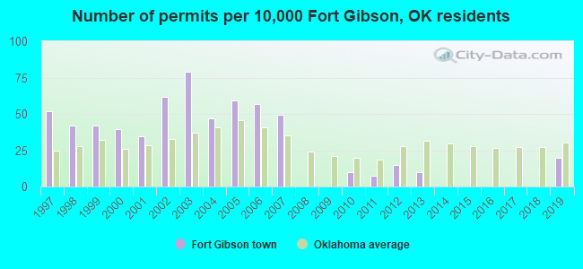
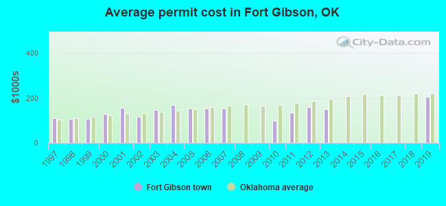
Single-family new house construction building permits:
- 2019: 8 buildings, average cost: $204,900
- 2013: 4 buildings, average cost: $150,000
- 2012: 6 buildings, average cost: $158,300
- 2011: 3 buildings, average cost: $133,300
- 2010: 4 buildings, average cost: $96,500
- 2007: 20 buildings, average cost: $152,600
- 2006: 23 buildings, average cost: $152,600
- 2005: 24 buildings, average cost: $152,600
- 2004: 19 buildings, average cost: $168,900
- 2003: 32 buildings, average cost: $148,100
- 2002: 25 buildings, average cost: $115,100
- 2001: 14 buildings, average cost: $155,400
- 2000: 16 buildings, average cost: $127,100
- 1999: 17 buildings, average cost: $107,100
- 1998: 17 buildings, average cost: $105,500
- 1997: 21 buildings, average cost: $110,900
| Here: | 4.1% |
| Oklahoma: | 3.2% |
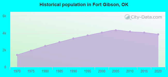
Population change in the 1990s: +647 (+19.0%).
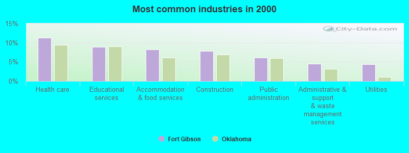
- Health care (11.3%)
- Educational services (8.9%)
- Accommodation & food services (8.3%)
- Construction (7.8%)
- Public administration (6.1%)
- Administrative & support & waste management services (4.5%)
- Utilities (4.4%)
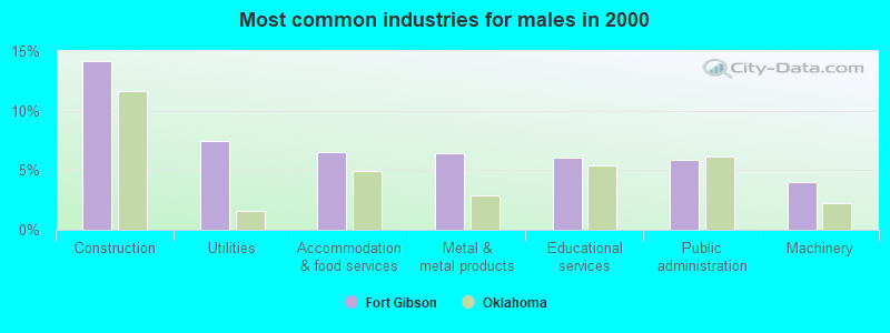
- Construction (14.1%)
- Utilities (7.5%)
- Accommodation & food services (6.5%)
- Metal & metal products (6.4%)
- Educational services (6.0%)
- Public administration (5.9%)
- Machinery (4.0%)
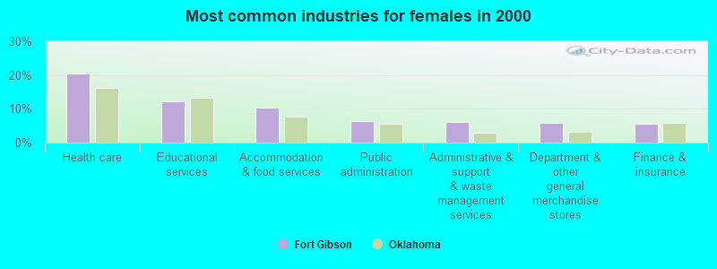
- Health care (20.5%)
- Educational services (12.2%)
- Accommodation & food services (10.3%)
- Public administration (6.4%)
- Administrative & support & waste management services (6.1%)
- Department & other general merchandise stores (5.8%)
- Finance & insurance (5.4%)
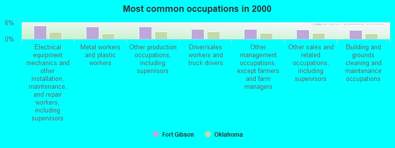
- Electrical equipment mechanics and other installation, maintenance, and repair workers, including supervisors (5.0%)
- Metal workers and plastic workers (4.6%)
- Other production occupations, including supervisors (4.6%)
- Driver/sales workers and truck drivers (3.7%)
- Other management occupations, except farmers and farm managers (3.7%)
- Other sales and related occupations, including supervisors (3.5%)
- Building and grounds cleaning and maintenance occupations (3.3%)
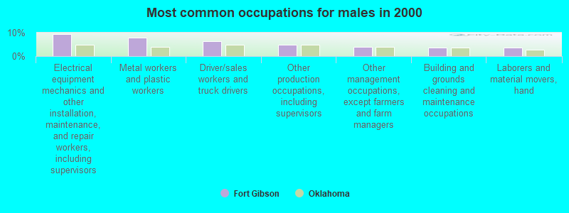
- Electrical equipment mechanics and other installation, maintenance, and repair workers, including supervisors (9.3%)
- Metal workers and plastic workers (7.8%)
- Driver/sales workers and truck drivers (6.4%)
- Other production occupations, including supervisors (4.8%)
- Other management occupations, except farmers and farm managers (3.9%)
- Building and grounds cleaning and maintenance occupations (3.7%)
- Laborers and material movers, hand (3.5%)
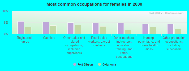
- Registered nurses (5.4%)
- Cashiers (5.2%)
- Other sales and related occupations, including supervisors (5.0%)
- Retail sales workers, except cashiers (4.8%)
- Other teachers, instructors, education, training, and library occupations (4.7%)
- Nursing, psychiatric, and home health aides (4.5%)
- Other production occupations, including supervisors (4.4%)
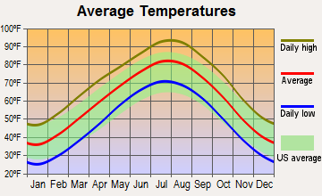
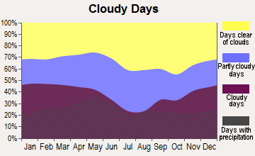
Average climate in Fort Gibson, Oklahoma
Based on data reported by over 4,000 weather stations
|
|

(lower is better)
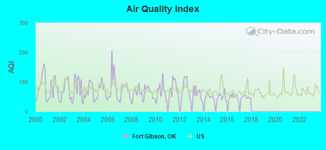
Air Quality Index (AQI) level in 2017 was 47.7. This is significantly better than average.
| City: | 47.7 |
| U.S.: | 72.6 |
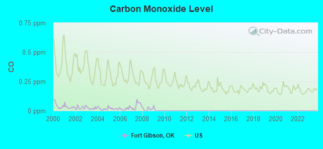
Carbon Monoxide (CO) [ppm] level in 2008 was 0.0173. This is significantly better than average. Closest monitor was 15.5 miles away from the city center.
| City: | 0.0173 |
| U.S.: | 0.2513 |
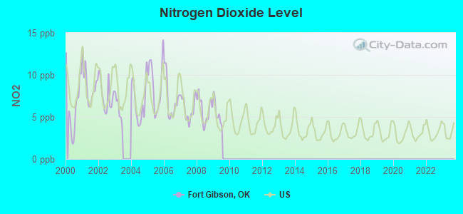
Nitrogen Dioxide (NO2) [ppb] level in 2009 was 5.52. This is about average. Closest monitor was 5.1 miles away from the city center.
| City: | 5.52 |
| U.S.: | 5.11 |
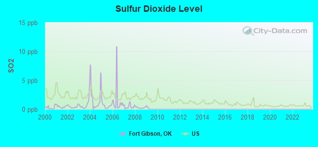
Sulfur Dioxide (SO2) [ppb] level in 2008 was 0.284. This is significantly better than average. Closest monitor was 5.1 miles away from the city center.
| City: | 0.284 |
| U.S.: | 1.515 |
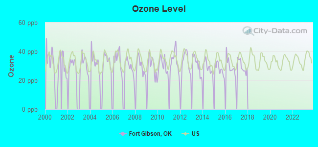
Ozone [ppb] level in 2017 was 29.8. This is about average. Closest monitor was 1.8 miles away from the city center.
| City: | 29.8 |
| U.S.: | 33.3 |
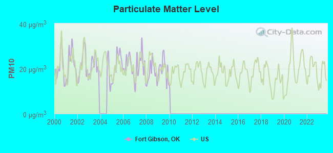
Particulate Matter (PM10) [µg/m3] level in 2009 was 20.2. This is about average. Closest monitor was 1.8 miles away from the city center.
| City: | 20.2 |
| U.S.: | 19.2 |
Tornado activity:
Fort Gibson-area historical tornado activity is near Oklahoma state average. It is 151% greater than the overall U.S. average.
On 5/26/1973, a category F4 (max. wind speeds 207-260 mph) tornado 14.9 miles away from the Fort Gibson town center killed 5 people and injured 25 people and caused between $50,000 and $500,000 in damages.
On 6/1/1999, a category F3 (max. wind speeds 158-206 mph) tornado 7.3 miles away from the town center killed 2 people and injured 5 people and caused $2 million in damages.
Earthquake activity:
Fort Gibson-area historical earthquake activity is significantly above Oklahoma state average. It is 724% greater than the overall U.S. average.On 9/3/2016 at 12:02:44, a magnitude 5.8 (5.8 MW, Depth: 3.5 mi, Class: Moderate, Intensity: VI - VII) earthquake occurred 103.3 miles away from the city center
On 11/6/2011 at 03:53:10, a magnitude 5.7 (5.7 MW, Depth: 3.2 mi) earthquake occurred 86.9 miles away from Fort Gibson center
On 11/7/2016 at 01:44:24, a magnitude 5.0 (5.0 MW, Depth: 2.8 mi) earthquake occurred 87.9 miles away from the city center
On 11/5/2011 at 07:12:45, a magnitude 4.8 (4.8 MW, Depth: 1.9 mi, Class: Light, Intensity: IV - V) earthquake occurred 86.6 miles away from Fort Gibson center
On 11/8/2011 at 02:46:57, a magnitude 4.8 (4.8 MW, Depth: 3.1 mi) earthquake occurred 88.2 miles away from the city center
On 2/13/2016 at 17:07:06, a magnitude 5.1 (5.1 MW, Depth: 5.2 mi) earthquake occurred 198.9 miles away from the city center
Magnitude types: moment magnitude (MW)
Natural disasters:
The number of natural disasters in Muskogee County (27) is a lot greater than the US average (15).Major Disasters (Presidential) Declared: 16
Emergencies Declared: 6
Causes of natural disasters: Storms: 13, Floods: 12, Winter Storms: 10, Tornadoes: 9, Winds: 3, Fires: 2, Hurricane: 1, Snow: 1, Other: 1 (Note: some incidents may be assigned to more than one category).

Hospitals and medical centers in Fort Gibson:
Other hospitals and medical centers near Fort Gibson:
- EASTGATE VILLAGE RETIREMENT CENTER (Nursing Home, about 6 miles away; MUSKOGEE, OK)
- MED-CORP HOME HEALTH, INC (Home Health Center, about 6 miles away; MUSKOGEE, OK)
- SOONER HEALTH SERVICES I I, INC (Home Health Center, about 6 miles away; MUSKOGEE, OK)
- MUSKOGEE COMMUNITY HOSPITAL (Hospital, about 6 miles away; MUSKOGEE, OK)
- ENCOMPASS HOME HEALTH OF EASTERN OKLAHOMA (Home Health Center, about 7 miles away; MUSKOGEE, OK)
- TLC HOME HEALTH CARE OF OK (Home Health Center, about 7 miles away; MUSKOGEE, OK)
- YORK MANOR NURSING HOME (Nursing Home, about 7 miles away; MUSKOGEE, OK)
Colleges/universities with over 2000 students nearest to Fort Gibson:
- Northeastern State University (about 19 miles; Tahlequah, OK; Full-time enrollment: 6,895)
- Oklahoma State University Institute of Technology (about 41 miles; Okmulgee, OK; FT enrollment: 3,243)
- Rogers State University (about 43 miles; Claremore, OK; FT enrollment: 3,482)
- Tulsa Community College (about 43 miles; Tulsa, OK; FT enrollment: 12,480)
- Oral Roberts University (about 44 miles; Tulsa, OK; FT enrollment: 3,216)
- University of Tulsa (about 46 miles; Tulsa, OK; FT enrollment: 3,702)
- John Brown University (about 48 miles; Siloam Springs, AR; FT enrollment: 2,097)
Public high school in Fort Gibson:
- FORT GIBSON HS (Students: 563, Location: 500 SOUTH ROSS AVENUE, Grades: 9-12)
Private high school in Fort Gibson:
Public elementary/middle schools in Fort Gibson:
- FORT GIBSON EARLY LRNING CTR (Students: 462, Location: 500 SOUTH ROSS AVENUE, Grades: PK-2)
- FORT GIBSON MS (Students: 433, Location: 500 SOUTH ROSS AVENUE, Grades: 6-8)
- FORT GIBSON INTERMEDIATE ES (Location: 500 SOUTH ROSS AVENUE, Grades: 3-5)
Points of interest:
Notable location: Fort Gibson Fire Department (A). Display/hide its location on the map
Churches in Fort Gibson include: Fort Gibson Church of Christ (A), First United Methodist Church (B), First Baptist Church (C). Display/hide their locations on the map
Cemeteries: Fort Gibson Cemetery (1), Fort Gibson National Cemetery (2), New Hope Cemetery (3). Display/hide their locations on the map
Lakes: Ross Lake (A), Horseshoe Lake (B), Katy Lake (C), Shimoon Lake (D). Display/hide their locations on the map
Streams, rivers, and creeks: Correll Branch (A), Dry Branch (B). Display/hide their locations on the map
Park in Fort Gibson: Fort Gibson Stockade (1). Display/hide its location on the map
Tourist attraction: FT Gibson Historic Site (Historical Places & Services; 907 North Garrison).
Hotel: Cedar Inn (507 West Poplar Street).
Court: Ft Gibson Town - Court Clerk (200 East Hickory).
Birthplace of: Lee Wiley - (1915-1975), jazz singer, Frank Linzy - Baseball player, Jim Gladd - Baseball player.
Drinking water stations with addresses in Fort Gibson and their reported violations in the past:
FORT GIBSON (Population served: 4,700, Surface water):Past health violations:CHEROKEE CO RWD # 1 (FT GIBSON) (Population served: 710, Surface water):Past monitoring violations:
- MCL, Monthly (TCR) - In NOV-2005, Contaminant: Coliform. Follow-up actions: St Violation/Reminder Notice (DEC-19-2005), St Public Notif requested (DEC-19-2005), St Public Notif received (DEC-30-2005), St Compliance achieved (JAN-18-2006), St Public Notif received (JAN-18-2006)
- Monthly Turbidity Exceed (Enhanced SWTR) - In DEC-2013, Contaminant: IESWTR. Follow-up actions: St AO (w/penalty) issued (MAY-05-2014), St Public Notif requested (MAY-05-2014), St Compliance achieved (MAY-21-2014), St Public Notif received (MAY-21-2014)
- Monthly Turbidity Exceed (Enhanced SWTR) - In JUL-2013, Contaminant: IESWTR. Follow-up actions: St Public Notif requested (AUG-29-2013), St AO (w/penalty) issued (AUG-29-2013)
- Monthly Turbidity Exceed (Enhanced SWTR) - In AUG-2012, Contaminant: IESWTR. Follow-up actions: St Public Notif received (NOV-15-2013), St Compliance achieved (NOV-19-2013), St Public Notif requested (NOV-19-2013)
- Monthly Turbidity Exceed (Enhanced SWTR) - In JUL-2012, Contaminant: IESWTR. Follow-up actions: St Public Notif received (NOV-15-2013), St Compliance achieved (NOV-19-2013), St Public Notif requested (NOV-19-2013)
- Monthly Turbidity Exceed (Enhanced SWTR) - In JUN-2012, Contaminant: IESWTR. Follow-up actions: St Public Notif received (NOV-15-2013), St Compliance achieved (NOV-19-2013), St Public Notif requested (NOV-19-2013)
- 2 routine major monitoring violations
- 4 minor monitoring violations
- 2 regular monitoring violations
- 37 other older monitoring violations
Past health violations:CORRAL KREEK SUBDIV (Population served: 273, Purch surface water):Past monitoring violations:
- MCL, Average - Between JUL-2009 and SEP-2009, Contaminant: TTHM. Follow-up actions: St AO (w/penalty) issued (OCT-27-2009), St Public Notif requested (OCT-27-2009), St Public Notif received (DEC-01-2009), St Compliance achieved (MAY-17-2010)
- MCL, Average - Between APR-2009 and JUN-2009, Contaminant: TTHM. Follow-up actions: St AO (w/penalty) issued (AUG-07-2009), St Public Notif requested (AUG-07-2009), St Public Notif received (AUG-31-2009), St Compliance achieved (MAY-17-2010)
- MCL, Average - Between JAN-2009 and MAR-2009, Contaminant: TTHM. Follow-up actions: St AO (w/penalty) issued (APR-23-2009), St Public Notif requested (APR-23-2009), St Public Notif received (JUN-01-2009), St Compliance achieved (MAY-17-2010)
- MCL, Average - Between OCT-2008 and DEC-2008, Contaminant: TTHM. Follow-up actions: St AO (w/penalty) issued (JAN-27-2009), St Public Notif requested (JAN-27-2009), St Public Notif received (MAR-02-2009), St Compliance achieved (MAY-17-2010)
- MCL, Average - Between APR-2008 and JUN-2008, Contaminant: Total Haloacetic Acids (HAA5). Follow-up actions: St AO (w/penalty) issued (AUG-26-2008), St Public Notif requested (AUG-26-2008), St Public Notif received (FEB-02-2009), St Compliance achieved (MAY-17-2010)
- MCL, Average - Between JAN-2008 and MAR-2008, Contaminant: Total Haloacetic Acids (HAA5). Follow-up actions: St AO (w/penalty) issued (AUG-26-2008), St Public Notif requested (AUG-26-2008), St Public Notif received (FEB-02-2009), St Compliance achieved (MAY-17-2010)
- 5 other older health violations
- Monthly Turbidity Exceed (Enhanced SWTR) - In MAR-2014, Contaminant: IESWTR. Follow-up actions: St Public Notif requested (2 times from MAY-01-2014 to MAY-01-2014), St AO (w/penalty) issued (2 times from MAY-01-2014 to MAY-01-2014), St Compliance achieved (MAY-29-2014), St Public Notif received (MAY-29-2014)
- Single Turbidity Exceed (Enhanced SWTR) - In FEB-2014, Contaminant: IESWTR. Follow-up actions: St Public Notif requested (2 times from MAY-01-2014 to MAY-01-2014), St AO (w/penalty) issued (2 times from MAY-01-2014 to MAY-01-2014), St Compliance achieved (MAY-29-2014), St Public Notif received (MAY-29-2014)
- Monthly Turbidity Exceed (Enhanced SWTR) - In FEB-2014, Contaminant: IESWTR. Follow-up actions: St AO (w/penalty) issued (MAY-01-2014), St Public Notif requested (MAY-01-2014), St Compliance achieved (MAY-29-2014), St Public Notif received (MAY-29-2014)
- Treatment Technique Precursor Removal - Between JAN-2014 and MAR-2014, Contaminant: CARBON, TOTAL. Follow-up actions: St AO (w/penalty) issued (JUN-20-2014), St Public Notif requested (JUN-20-2014), St Public Notif received (JUN-30-2014)
- Monthly Turbidity Exceed (Enhanced SWTR) - In NOV-2013, Contaminant: IESWTR. Follow-up actions: St AO (w/penalty) issued (MAY-01-2014), St Public Notif requested (MAY-01-2014), St Compliance achieved (MAY-29-2014), St Public Notif received (MAY-29-2014)
- 11 other older monitoring violations
Past monitoring violations:
- Initial Tap Sampling for Pb and Cu - In JUN-01-1993, Contaminant: Lead and Copper Rule. Follow-up actions: St AO (w/o penalty) issued (NOV-17-1994), Fed Formal NOV issued (MAY-01-1995), Fed FAO issued (SEP-22-1997), Fed Compliance achieved (OCT-18-2005), St Compliance achieved (OCT-18-2005), Fed Compliance achieved (OCT-18-2005)
- One routine major monitoring violation
| This town: | 2.6 people |
| Oklahoma: | 2.5 people |
| This town: | 73.2% |
| Whole state: | 66.8% |
| This town: | 6.3% |
| Whole state: | 5.9% |
Likely homosexual households (counted as self-reported same-sex unmarried-partner households)
- Lesbian couples: 0.2% of all households
- Gay men: 0.3% of all households
65 people in nursing homes in 2000
Banks with branches in Fort Gibson (2011 data):
- Fort Gibson State Bank: at South Lee Street And Maple Avenue, branch established on 1973/05/21. Info updated 2006/11/03: Bank assets: $56.3 mil, Deposits: $51.3 mil, local headquarters, positive income, Commercial Lending Specialization, 1 total offices, Holding Company: Three Rivers Bankshares, Inc.
- Armstrong Bank: Fort Gibson Branch at 803 South Lee Street, branch established on 2009/11/18. Info updated 2009/01/14: Bank assets: $579.7 mil, Deposits: $498.3 mil, headquarters in Muskogee, OK, positive income, Commercial Lending Specialization, 17 total offices, Holding Company: Ironhorse Financial Group, Inc.
For population 15 years and over in Fort Gibson:
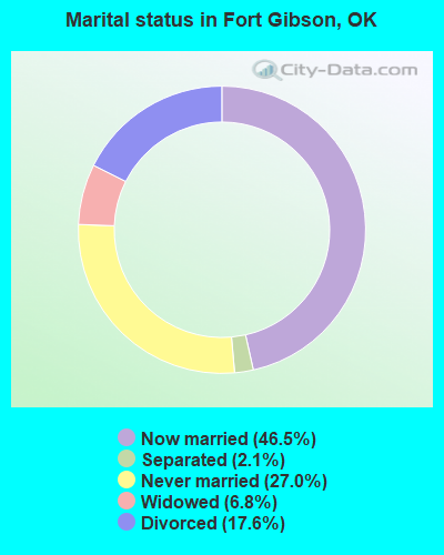
- Never married: 27.0%
- Now married: 46.5%
- Separated: 2.1%
- Widowed: 6.8%
- Divorced: 17.6%
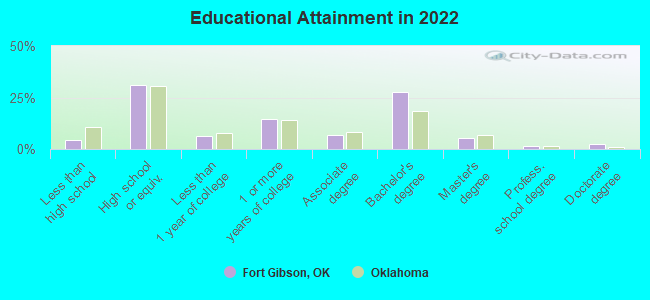
For population 25 years and over in Fort Gibson:
- High school or higher: 94.8%
- Bachelor's degree or higher: 37.3%
- Graduate or professional degree: 8.2%
- Unemployed: 6.8%
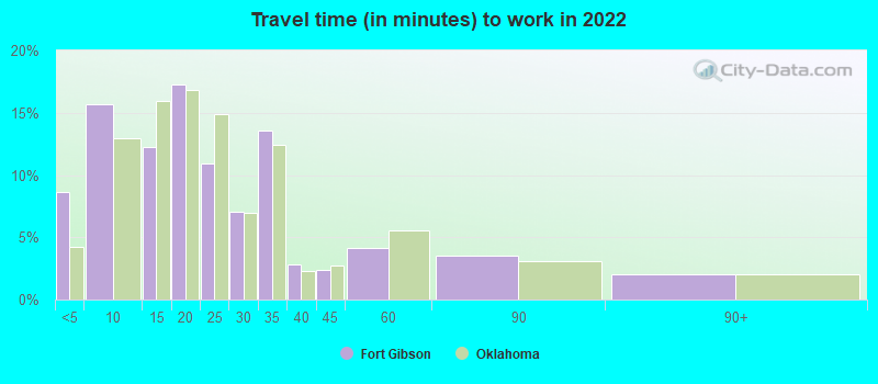
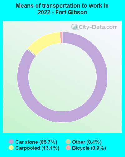
- Mean travel time to work (commute): 21.2 minutes
| Here: | 10.1 |
| Oklahoma average: | 11.3 |
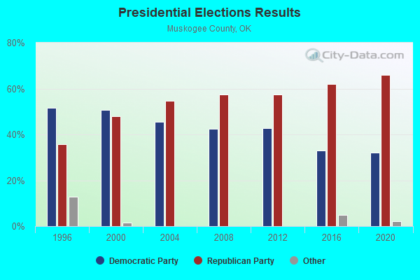
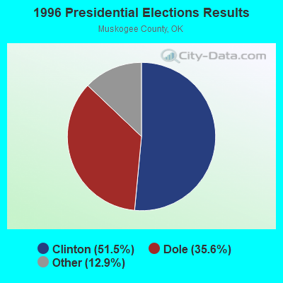
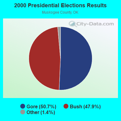
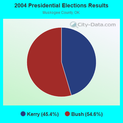
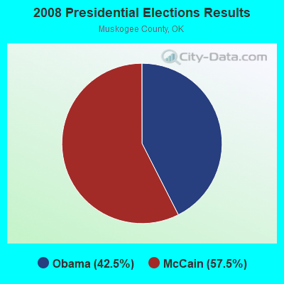
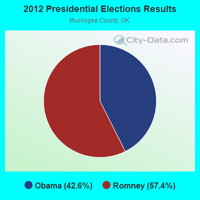
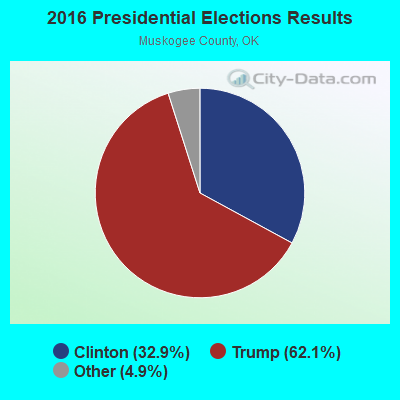
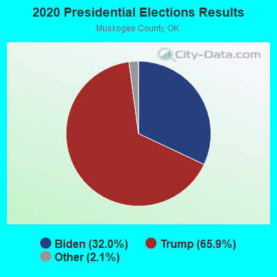
Graphs represent county-level data. Detailed 2008 Election Results
Religion statistics for Fort Gibson, OK (based on Muskogee County data)
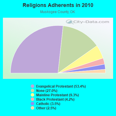
| Religion | Adherents | Congregations |
|---|---|---|
| Evangelical Protestant | 37,906 | 135 |
| Mainline Protestant | 6,616 | 19 |
| Black Protestant | 2,986 | 16 |
| Catholic | 2,500 | 2 |
| Other | 1,781 | 6 |
| None | 19,201 | - |
Food Environment Statistics:
| Here: | 2.25 / 10,000 pop. |
| Oklahoma: | 1.97 / 10,000 pop. |
| This county: | 0.84 / 10,000 pop. |
| Oklahoma: | 0.76 / 10,000 pop. |
| Muskogee County: | 4.51 / 10,000 pop. |
| Oklahoma: | 4.35 / 10,000 pop. |
| Muskogee County: | 6.48 / 10,000 pop. |
| Oklahoma: | 6.89 / 10,000 pop. |
| Here: | 12.8% |
| Oklahoma: | 10.3% |
| Muskogee County: | 31.9% |
| State: | 29.2% |
Health and Nutrition:
| Fort Gibson: | 56.4% |
| Oklahoma: | 48.6% |
| This city: | 56.9% |
| State: | 45.2% |
| Fort Gibson: | 28.0 |
| Oklahoma: | 28.7 |
| This city: | 16.2% |
| Oklahoma: | 21.4% |
| Fort Gibson: | 5.2% |
| State: | 10.8% |
| This city: | 6.8 |
| State: | 6.8 |
| Fort Gibson: | 31.3% |
| Oklahoma: | 33.9% |
| Here: | 62.9% |
| Oklahoma: | 55.2% |
| Fort Gibson: | 81.6% |
| Oklahoma: | 78.4% |
More about Health and Nutrition of Fort Gibson, OK Residents
| Local government employment and payroll (March 2022) | |||||
| Function | Full-time employees | Monthly full-time payroll | Average yearly full-time wage | Part-time employees | Monthly part-time payroll |
|---|---|---|---|---|---|
| Police Protection - Officers | 14 | $60,062 | $51,482 | 0 | $0 |
| Water Supply | 8 | $30,701 | $46,052 | 2 | $3,068 |
| Other and Unallocable | 4 | $13,360 | $40,080 | 0 | $0 |
| Firefighters | 4 | $14,271 | $42,813 | 15 | $7,500 |
| Solid Waste Management | 4 | $5,256 | $15,768 | 0 | $0 |
| Sewerage | 3 | $11,816 | $47,264 | 0 | $0 |
| Judicial and Legal | 2 | $5,434 | $32,604 | 0 | $0 |
| Financial Administration | 2 | $6,395 | $38,370 | 0 | $0 |
| Other Government Administration | 2 | $8,439 | $50,634 | 5 | $2,350 |
| Streets and Highways | 1 | $3,026 | $36,312 | 0 | $0 |
| Police - Other | 1 | $3,366 | $40,392 | 0 | $0 |
| Health | 1 | $3,066 | $36,792 | 0 | $0 |
| Totals for Government | 46 | $165,192 | $43,094 | 22 | $12,918 |
Fort Gibson government finances - Expenditure in 2021 (per resident):
- Construction - Water Utilities: $2,482,000 ($651.44)
Sewerage: $475,000 ($124.67)
- Current Operations - Water Utilities: $1,046,000 ($274.54)
Police Protection: $830,000 ($217.85)
General - Other: $777,000 ($203.94)
Sewerage: $574,000 ($150.66)
Financial Administration: $318,000 ($83.46)
Solid Waste Management: $307,000 ($80.58)
Local Fire Protection: $190,000 ($49.87)
Regular Highways: $123,000 ($32.28)
Miscellaneous Commercial Activities - Other: $77,000 ($20.21)
Judicial and Legal Services: $71,000 ($18.64)
Protective Inspection and Regulation - Other: $67,000 ($17.59)
Parks and Recreation: $65,000 ($17.06)
Health - Other: $51,000 ($13.39)
Libraries: $26,000 ($6.82)
- General - Interest on Debt: $11,000 ($2.89)
- Other Capital Outlay - Regular Highways: $136,000 ($35.70)
Solid Waste Management: $111,000 ($29.13)
Police Protection: $91,000 ($23.88)
General - Other: $32,000 ($8.40)
Financial Administration: $23,000 ($6.04)
Parks and Recreation: $15,000 ($3.94)
Miscellaneous Commercial Activities - Other: $7,000 ($1.84)
Local Fire Protection: $7,000 ($1.84)
Health - Other: $5,000 ($1.31)
Sewerage: $2,000 ($0.52)
Water Utilities: $1,000 ($0.26)
Libraries: $1,000 ($0.26)
- Water Utilities - Interest on Debt: $60,000 ($15.75)
Fort Gibson government finances - Revenue in 2021 (per resident):
- Charges - Sewerage: $1,706,000 ($447.77)
Solid Waste Management: $448,000 ($117.59)
- Local Intergovernmental - Water Utilities: $815,000 ($213.91)
- Miscellaneous - Fines and Forfeits: $719,000 ($188.71)
Sale of Property: $120,000 ($31.50)
Interest Earnings: $100,000 ($26.25)
Donations From Private Sources: $3,000 ($0.79)
- Revenue - Water Utilities: $1,564,000 ($410.50)
- State Intergovernmental - Highways: $62,000 ($16.27)
General Local Government Support: $56,000 ($14.70)
Other: $41,000 ($10.76)
- Tax - General Sales and Gross Receipts: $1,821,000 ($477.95)
Public Utilities Sales: $174,000 ($45.67)
Property: $96,000 ($25.20)
Other: $1,000 ($0.26)
Fort Gibson government finances - Debt in 2021 (per resident):
- Long Term Debt - Beginning Outstanding - Unspecified Public Purpose: $2,874,000 ($754.33)
Outstanding Unspecified Public Purpose: $2,532,000 ($664.57)
Retired Unspecified Public Purpose: $342,000 ($89.76)
Fort Gibson government finances - Cash and Securities in 2021 (per resident):
- Bond Funds - Cash and Securities: $4,368,000 ($1146.46)
- Other Funds - Cash and Securities: $7,109,000 ($1865.88)
- Sinking Funds - Cash and Securities: $1,244,000 ($326.51)
| Businesses in Fort Gibson, OK | ||||
| Name | Count | Name | Count | |
|---|---|---|---|---|
| Cricket Wireless | 1 | Subway | 1 | |
| Jones New York | 1 | True Value | 1 | |
| McDonald's | 1 | U-Haul | 1 | |
| SONIC Drive-In | 1 | |||
Strongest AM radio stations in Fort Gibson:
- KFAQ (1170 AM; 50 kW; TULSA, OK; Owner: JOURNAL BROADCAST CORPORATION)
- KRMG (740 AM; 50 kW; TULSA, OK; Owner: CXR HOLDINGS, INC.)
- KBIX (1490 AM; 1 kW; MUSKOGEE, OK; Owner: KMMY INC.)
- KXTD (1530 AM; daytime; 5 kW; WAGONER, OK; Owner: GAYTAN-GALVAN LIMITED LIABILITY COMP)
- KTBZ (1430 AM; 25 kW; TULSA, OK; Owner: CLEAR CHANNEL BROADCASTING LICENSES, INC.)
- KMUS (1380 AM; 20 kW; MUSKOGEE, OK; Owner: ABC, INC.)
- KAKC (1300 AM; 5 kW; TULSA, OK; Owner: CLEAR CHANNEL BROADCASTING LICENSES, INC.)
- KFAY (1030 AM; 10 kW; FARMINGTON, AR; Owner: CUMULUS LICENSING CORP)
- KYHN (1320 AM; 10 kW; FORT SMITH, AR; Owner: CAPSTAR TX LIMITED PARTNERSHIP)
- KTLQ (1350 AM; 1 kW; TAHLEQUAH, OK; Owner: JOHNSON COMMUNICATIONS, INC.)
- KOMA (1520 AM; 50 kW; OKLAHOMA CITY, OK; Owner: RENDA BROADCASTING CORP. OF NEVADA)
- KWHN (1650 AM; 10 kW; FT. SMITH, AR; Owner: CAPSTAR TX LIMITED PARTNERSHIP)
- KUOA (1290 AM; 5 kW; SILOAM SPRINGS, AR; Owner: KUOA, INC.)
Strongest FM radio stations in Fort Gibson:
- KNYD (90.5 FM; BROKEN ARROW, OK; Owner: CREATIVE EDUCATIONAL MEDIA CORP. INC)
- KJSR (103.3 FM; TULSA, OK; Owner: CXR HOLDINGS, INC.)
- KCXR (100.3 FM; TAFT, OK; Owner: KXOJ INC.)
- KMYZ-FM (104.5 FM; PRYOR, OK; Owner: SHAMROCK COMMUNICATIONS, INC.)
- KWGS (89.5 FM; TULSA, OK; Owner: THE UNIVERSITY OF TULSA)
- KHTT (106.9 FM; MUSKOGEE, OK; Owner: RENDA BROADCASTING CORP. OF NEVADA)
- KTFX-FM (102.1 FM; WARNER, OK; Owner: K95.5, INC)
- KMMY (97.1 FM; MUSKOGEE, OK; Owner: KMMY, Inc.)
- KZBB (97.9 FM; POTEAU, OK; Owner: CAPSTAR TX LIMITED PARTNERSHIP)
- KMAG (99.1 FM; FORT SMITH, AR; Owner: CAPSTAR TX LIMITED PARTNERSHIP)
- KTCS-FM (99.9 FM; FORT SMITH, AR; Owner: BIG CHIEF BROADCASTING COMPANY)
- K204EW (88.7 FM; POTEAU, OK; Owner: CALVARY CHAPEL OF TWIN FALLS, INC.)
- K219CN (91.7 FM; POTEAU, OK; Owner: AMERICAN FAMILY ASSOCIATION)
- KTKL (88.5 FM; STIGLER, OK; Owner: EDUCATIONAL MEDIA FOUNDATION)
- KARG (91.7 FM; POTEAU, OK; Owner: AMERICAN FAMILY ASSOCIATION)
- KJMM (105.3 FM; BIXBY, OK; Owner: KJMM, INC.)
- KEOK (101.7 FM; TAHLEQUAH, OK; Owner: JOHNSON COMMUNICATIONS, INC.)
- K204CA (88.7 FM; TAHLEQUAH, OK; Owner: THE MOODY BIBLE INSTITUTE OF CHICAGO)
TV broadcast stations around Fort Gibson:
- K31DY (Channel 31; MUSKOGEE, OK; Owner: LOCKE SUPPLY CO.)
- KTUL (Channel 8; TULSA, OK; Owner: KTUL, LLC)
- KJRH (Channel 2; TULSA, OK; Owner: SCRIPPS HOWARD BROADCASTING COMPANY)
- KOED-TV (Channel 11; TULSA, OK; Owner: OKLAHOMA EDUCATIONAL TELEVISION AUTHORITY)
- K25GJ (Channel 25; MUSKOGEE, OK; Owner: TRINITY BROADCASTING NETWORK)
- KOTV (Channel 6; TULSA, OK; Owner: GRIFFIN LICENSING, L.L.C.)
- KTFO (Channel 41; TULSA, OK; Owner: CLEAR CHANNEL BROADCASTING LICENSES, INC.)
- KWHB (Channel 47; TULSA, OK; Owner: LESEA BROADCASTING CORPORATION)
- KOKI-TV (Channel 23; TULSA, OK; Owner: CLEAR CHANNEL BROADCASTING LICENSES, INC.)
- KWBT (Channel 19; MUSKOGEE, OK; Owner: TULSA COMMUNICATIONS, L.L.C.)
- K52GX (Channel 52; TAHLEQUAH, OK; Owner: TRINITY BROADCASTING NETWORK)
- National Bridge Inventory (NBI) Statistics
- 22Number of bridges
- 400ft / 122mTotal length
- $20,771,000Total costs
- 91,940Total average daily traffic
- 14,445Total average daily truck traffic
- 146,124Total future (year 2040) average daily traffic
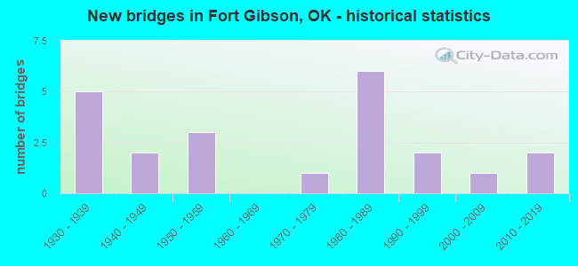
- New bridges - historical statistics
- 51930-1939
- 21940-1949
- 31950-1959
- 11970-1979
- 61980-1989
- 21990-1999
- 12000-2009
- 22010-2019
FCC Registered Cell Phone Towers:
1 (See the full list of FCC Registered Cell Phone Towers in Fort Gibson)FCC Registered Antenna Towers:
30 (See the full list of FCC Registered Antenna Towers)FCC Registered Broadcast Land Mobile Towers:
8 (See the full list of FCC Registered Broadcast Land Mobile Towers in Fort Gibson, OK)FCC Registered Microwave Towers:
10 (See the full list of FCC Registered Microwave Towers in this town)FCC Registered Amateur Radio Licenses:
28 (See the full list of FCC Registered Amateur Radio Licenses in Fort Gibson)FAA Registered Aircraft Manufacturers and Dealers:
3- TERRAPIN MACK DBA, 8062 N 59th St E, Fort Gibson, OK 74434
Certificate: 04-2121 (Individual), Certificate Issue Date: 12/01/2004, Expiration Date: 11/30/2005 - TMR AIRCRAFT LLC, Po Box 1267, Fort Gibson, OK 74434
Certificate: D000208 (LLC), Certificate Issue Date: 10/27/2020, Expiration Date: 10/26/2021 - TMR AIRCRAFT LLC, Po Box 1267, Fort Gibson, OK 74434
Certificate: D000208 (Corporation), Certificate Issue Date: 10/02/2017, Expiration Date: 10/01/2018
FAA Registered Aircraft:
3- Aircraft: MICHAEL RENE BROWN VANS RV-4 (Category: Land, Seats: 2, Weight: Up to 12,499 Pounds), Engine: LYCOMING O-320-A1A (150 HP) (Reciprocating)
N-Number: 457PM, N457PM, N-457PM, Serial Number: 2108, Year manufactured: 2018, Airworthiness Date: 06/13/2018, Certificate Issue Date: 05/24/2018
Registrant (Individual): Michael R Brown, 24950 S Manard Rd, Fort Gibson, OK 74434 - Aircraft: SOCATA TBM 700 (Category: Land, Seats: 7, Weight: Up to 12,499 Pounds), Engine: P&W PT6A SER (750 HP) (Turbo-prop)
N-Number: 726RY, N726RY, N-726RY, Serial Number: 235, Year manufactured: 2002, Airworthiness Date: 08/15/2002
Registrant (LLC): Tmr Aircraft LLC, Po Box 1267, Fort Gibson, OK 74434 - Aircraft: SOCATA TBM 700 (Category: Land, Seats: 7, Weight: Up to 12,499 Pounds), Engine: P&W PT6A SER (750 HP) (Turbo-prop)
N-Number: 335MA, N335MA, N-335MA, Serial Number: 235, Year manufactured: 2002, Airworthiness Date: 08/15/2002
Registrant (Corporation): Tmr Aircraft LLC, Po Box 1267, Fort Gibson, OK 74434
| Most common first names in Fort Gibson, OK among deceased individuals | ||
| Name | Count | Lived (average) |
|---|---|---|
| William | 40 | 76.1 years |
| John | 36 | 77.4 years |
| James | 30 | 74.7 years |
| Mary | 29 | 76.5 years |
| Charles | 21 | 71.8 years |
| Thomas | 18 | 78.2 years |
| George | 18 | 75.9 years |
| Robert | 17 | 70.8 years |
| Anna | 16 | 76.4 years |
| Willie | 14 | 80.2 years |
| Most common last names in Fort Gibson, OK among deceased individuals | ||
| Last name | Count | Lived (average) |
|---|---|---|
| Johnson | 22 | 77.1 years |
| Brown | 19 | 72.9 years |
| Smith | 18 | 75.2 years |
| Taylor | 17 | 70.0 years |
| Harris | 17 | 70.0 years |
| Cook | 14 | 80.5 years |
| Martin | 14 | 78.2 years |
| Cooper | 13 | 72.2 years |
| Bailey | 13 | 75.0 years |
| Anderson | 12 | 73.0 years |
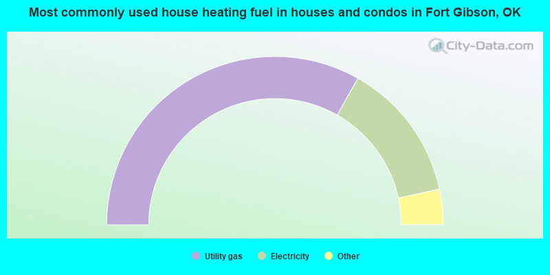
- 66.5%Utility gas
- 26.8%Electricity
- 3.7%Bottled, tank, or LP gas
- 3.0%Wood
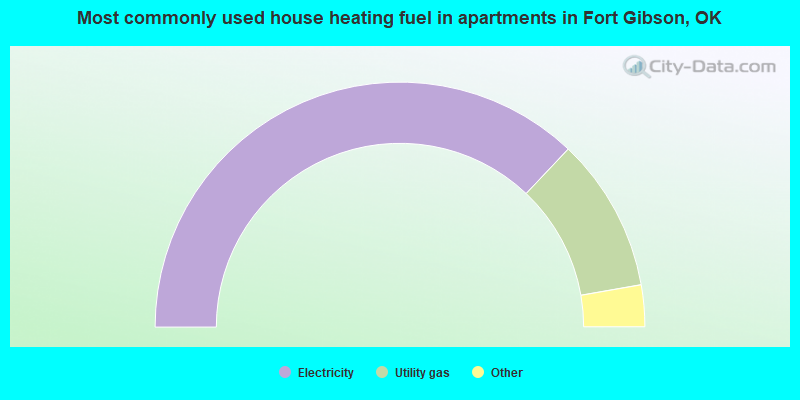
- 74.2%Electricity
- 20.4%Utility gas
- 3.4%Wood
- 2.0%No fuel used
Fort Gibson compared to Oklahoma state average:
- Unemployed percentage below state average.
- Black race population percentage significantly below state average.
- Hispanic race population percentage below state average.
- Foreign-born population percentage below state average.
- Length of stay since moving in above state average.
- Percentage of population with a bachelor's degree or higher above state average.

|
|
Total of 9 patent applications in 2008-2024.