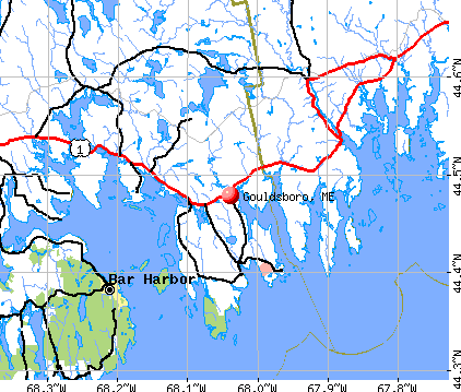
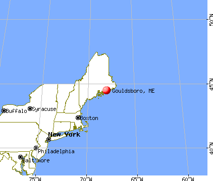
Gouldsboro, Maine

Submit your own pictures of this town and show them to the world
- OSM Map
- General Map
- Google Map
- MSN Map
Population change since 2000: -10.5%
 |
| Males: 874 | |
| Females: 863 |
| Median resident age: | 50.3 years |
| Maine median age: | 43.0 years |
Zip codes: 04607.
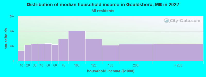
| Gouldsboro: | $66,698 |
| ME: | $69,543 |
Estimated per capita income in 2022: $36,960 (it was $18,203 in 2000)
Gouldsboro town income, earnings, and wages data
Estimated median house or condo value in 2022: $257,747 (it was $90,000 in 2000)
| Gouldsboro: | $257,747 |
| ME: | $290,600 |
Mean prices in 2022: all housing units: $379,336; detached houses: $396,802; townhouses or other attached units: $600,716; in 2-unit structures: $274,479; in 3-to-4-unit structures: $212,346; in 5-or-more-unit structures: $146,369; mobile homes: $158,183; occupied boats, rvs, vans, etc.: $16,454
Detailed information about poverty and poor residents in Gouldsboro, ME


- 1,67596.4%White alone
- 412.4%Hispanic
- 80.5%Two or more races
- 50.3%American Indian alone
- 30.2%Black alone
- 40.2%Asian alone
- 10.06%Other race alone
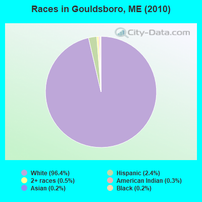
Races in Gouldsboro detailed stats: ancestries, foreign born residents, place of birth
According to our research of Maine and other state lists, there were 2 registered sex offenders living in Gouldsboro, Maine as of April 28, 2024.
The ratio of all residents to sex offenders in Gouldsboro is 869 to 1.
The ratio of registered sex offenders to all residents in this city is lower than the state average.
Type |
2009 |
2010 |
2011 |
2012 |
2013 |
2014 |
2015 |
2016 |
2017 |
2018 |
2019 |
2020 |
2021 |
2022 |
|---|---|---|---|---|---|---|---|---|---|---|---|---|---|---|
| Murders (per 100,000) | 0 (0.0) | 0 (0.0) | 0 (0.0) | 0 (0.0) | 0 (0.0) | 1 (57.3) | 0 (0.0) | 0 (0.0) | 0 (0.0) | 0 (0.0) | 0 (0.0) | 0 (0.0) | 0 (0.0) | 0 (0.0) |
| Rapes (per 100,000) | 0 (0.0) | 0 (0.0) | 0 (0.0) | 0 (0.0) | 0 (0.0) | 0 (0.0) | 0 (0.0) | 1 (57.5) | 0 (0.0) | 0 (0.0) | 0 (0.0) | 0 (0.0) | 0 (0.0) | 0 (0.0) |
| Robberies (per 100,000) | 0 (0.0) | 0 (0.0) | 0 (0.0) | 0 (0.0) | 0 (0.0) | 0 (0.0) | 0 (0.0) | 0 (0.0) | 0 (0.0) | 0 (0.0) | 0 (0.0) | 0 (0.0) | 0 (0.0) | 0 (0.0) |
| Assaults (per 100,000) | 0 (0.0) | 0 (0.0) | 0 (0.0) | 0 (0.0) | 1 (57.7) | 0 (0.0) | 0 (0.0) | 0 (0.0) | 0 (0.0) | 0 (0.0) | 0 (0.0) | 0 (0.0) | 0 (0.0) | 0 (0.0) |
| Burglaries (per 100,000) | 8 (400.2) | 9 (518.1) | 3 (172.7) | 4 (229.5) | 2 (115.4) | 8 (458.2) | 7 (402.1) | 11 (632.5) | 3 (171.4) | 1 (57.3) | 1 (57.3) | 0 (0.0) | 0 (0.0) | 0 (0.0) |
| Thefts (per 100,000) | 4 (200.1) | 6 (345.4) | 5 (287.9) | 12 (688.5) | 13 (750.1) | 7 (400.9) | 19 (1,091) | 15 (862.6) | 7 (400.0) | 3 (171.9) | 5 (286.5) | 3 (172.2) | 0 (0.0) | 0 (0.0) |
| Auto thefts (per 100,000) | 1 (50.0) | 0 (0.0) | 0 (0.0) | 1 (57.4) | 0 (0.0) | 1 (57.3) | 2 (114.9) | 1 (57.5) | 0 (0.0) | 0 (0.0) | 0 (0.0) | 2 (114.8) | 0 (0.0) | 0 (0.0) |
| Arson (per 100,000) | 0 (0.0) | 1 (57.6) | 0 (0.0) | 0 (0.0) | 0 (0.0) | 0 (0.0) | 0 (0.0) | 0 (0.0) | 0 (0.0) | 0 (0.0) | 0 (0.0) | 0 (0.0) | 0 (0.0) | 0 (0.0) |
| City-Data.com crime index | 40.0 | 50.1 | 23.6 | 48.2 | 49.6 | 167.2 | 81.0 | 129.4 | 28.0 | 10.9 | 15.5 | 16.1 | 0.0 | 0.0 |
The City-Data.com crime index weighs serious crimes and violent crimes more heavily. Higher means more crime, U.S. average is 246.1. It adjusts for the number of visitors and daily workers commuting into cities.
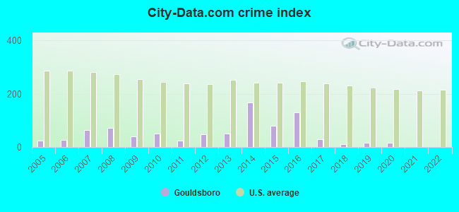
Crime rate in Gouldsboro detailed stats: murders, rapes, robberies, assaults, burglaries, thefts, arson
Full-time law enforcement employees in 2021, including police officers: 2 (2 officers - 2 male; 0 female).
| Officers per 1,000 residents here: | 1.15 |
| Maine average: | 1.71 |
 Recent articles from our blog. Our writers, many of them Ph.D. graduates or candidates, create easy-to-read articles on a wide variety of topics.

 | Gouldsboro (12 replies) |
| Maine or....... (23 replies) |
| info please about maine retirement (33 replies) |
| Maine blubeberry gift ideas (16 replies) |
| Just wanted to say thank you to the people of Maine! (31 replies) |
| Dover-Foxcroft: How to live on property while building (11 replies) |
Latest news from Gouldsboro, ME collected exclusively by city-data.com from local newspapers, TV, and radio stations
Gouldsboro, ME City Guides:
Ancestries: English (24.6%), United States (18.5%), Irish (11.5%), German (8.1%), French (5.0%), Scottish (4.0%).
Current Local Time: EST time zone
Incorporated on 02/16/1789
Elevation: 107 feet
Land area: 46.1 square miles.
Population density: 38 people per square mile (very low).
32 residents are foreign born
| This town: | 1.6% |
| Maine: | 2.9% |
| Gouldsboro town: | 1.0% ($914) |
| Maine: | 1.5% ($1,417) |
Nearest city with pop. 50,000+: Portland, ME  (122.6 miles , pop. 64,249).
Nearest city with pop. 200,000+: Boston, MA (211.4 miles , pop. 589,141).
Nearest city with pop. 1,000,000+: Bronx, NY (386.3 miles , pop. 1,332,650).
Nearest cities:
Latitude: 44.43 N, Longitude: 68.04 W
Area code commonly used in this area: 207

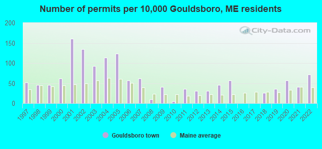
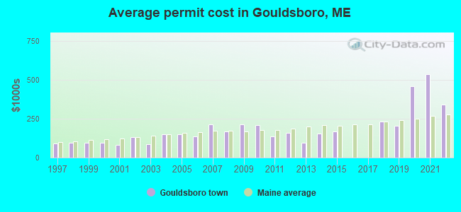
Single-family new house construction building permits:
- 2022: 14 buildings, average cost: $340,600
- 2021: 8 buildings, average cost: $535,000
- 2020: 11 buildings, average cost: $460,100
- 2019: 7 buildings, average cost: $202,700
- 2018: 5 buildings, average cost: $233,400
- 2015: 11 buildings, average cost: $165,500
- 2014: 9 buildings, average cost: $154,400
- 2013: 6 buildings, average cost: $93,300
- 2012: 6 buildings, average cost: $157,800
- 2011: 7 buildings, average cost: $133,600
- 2010: 1 building, cost: $210,000
- 2009: 8 buildings, average cost: $210,500
- 2008: 2 buildings, average cost: $167,500
- 2007: 12 buildings, average cost: $212,000
- 2006: 11 buildings, average cost: $135,200
- 2005: 24 buildings, average cost: $150,000
- 2004: 22 buildings, average cost: $150,000
- 2003: 18 buildings, average cost: $87,800
- 2002: 26 buildings, average cost: $132,900
- 2001: 31 buildings, average cost: $80,100
- 2000: 12 buildings, average cost: $94,100
- 1999: 9 buildings, average cost: $94,000
- 1998: 9 buildings, average cost: $94,800
- 1997: 10 buildings, average cost: $91,300
| Here: | 5.9% |
| Maine: | 3.4% |

- Agriculture, forestry, fishing & hunting (13.1%)
- Health care (8.4%)
- Construction (8.3%)
- Food (7.8%)
- Educational services (7.6%)
- Public administration (6.6%)
- Accommodation & food services (5.6%)
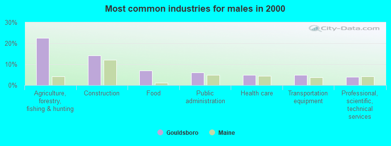
- Agriculture, forestry, fishing & hunting (22.6%)
- Construction (14.2%)
- Food (7.1%)
- Public administration (6.0%)
- Health care (4.9%)
- Transportation equipment (4.9%)
- Professional, scientific, technical services (4.0%)

- Educational services (15.1%)
- Health care (12.6%)
- Accommodation & food services (9.4%)
- Food (8.6%)
- Public administration (7.3%)
- Food & beverage stores (5.6%)
- Professional, scientific, technical services (5.6%)
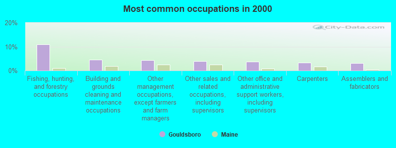
- Fishing, hunting, and forestry occupations (10.9%)
- Building and grounds cleaning and maintenance occupations (4.5%)
- Other management occupations, except farmers and farm managers (4.2%)
- Other sales and related occupations, including supervisors (4.0%)
- Other office and administrative support workers, including supervisors (3.6%)
- Carpenters (3.4%)
- Assemblers and fabricators (3.2%)

- Fishing, hunting, and forestry occupations (18.8%)
- Carpenters (5.8%)
- Electrical equipment mechanics and other installation, maintenance, and repair workers, including supervisors (4.6%)
- Other sales and related occupations, including supervisors (4.2%)
- Other management occupations, except farmers and farm managers (4.0%)
- Assemblers and fabricators (3.8%)
- Driver/sales workers and truck drivers (3.5%)
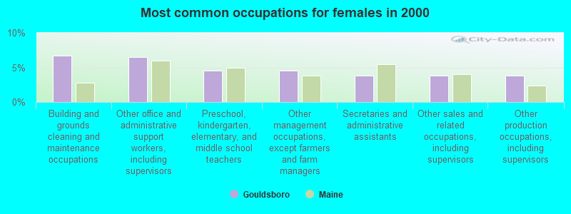
- Building and grounds cleaning and maintenance occupations (6.7%)
- Other office and administrative support workers, including supervisors (6.5%)
- Preschool, kindergarten, elementary, and middle school teachers (4.6%)
- Other management occupations, except farmers and farm managers (4.6%)
- Secretaries and administrative assistants (3.8%)
- Other sales and related occupations, including supervisors (3.8%)
- Other production occupations, including supervisors (3.8%)
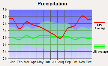
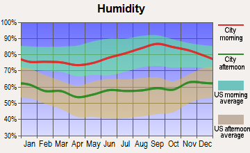
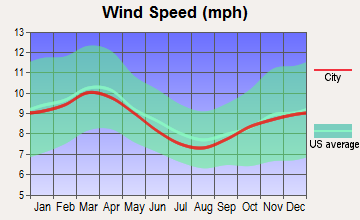
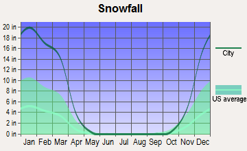
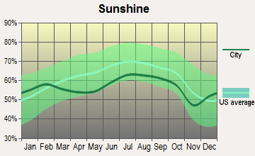
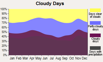
Average climate in Gouldsboro, Maine
Based on data reported by over 4,000 weather stations
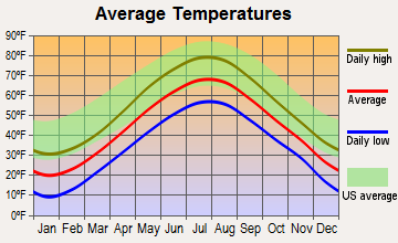
(lower is better)
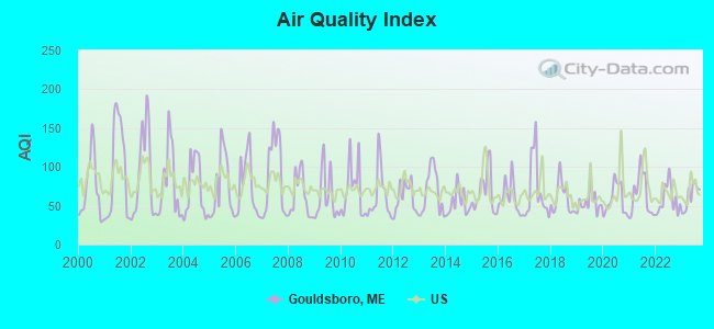
Air Quality Index (AQI) level in 2023 was 61.9. This is about average.
| City: | 61.9 |
| U.S.: | 72.6 |
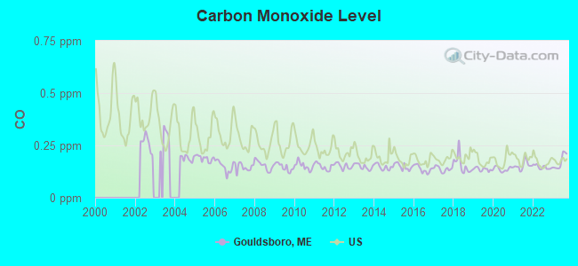
Carbon Monoxide (CO) [ppm] level in 2023 was 0.172. This is significantly better than average. Closest monitor was 10.5 miles away from the city center.
| City: | 0.172 |
| U.S.: | 0.251 |
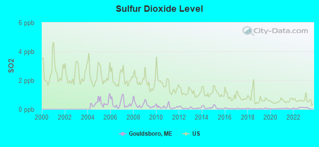
Sulfur Dioxide (SO2) [ppb] level in 2023 was 0.0636. This is significantly better than average. Closest monitor was 11.3 miles away from the city center.
| City: | 0.0636 |
| U.S.: | 1.5147 |
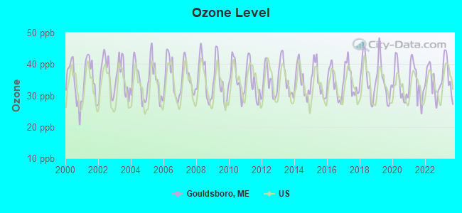
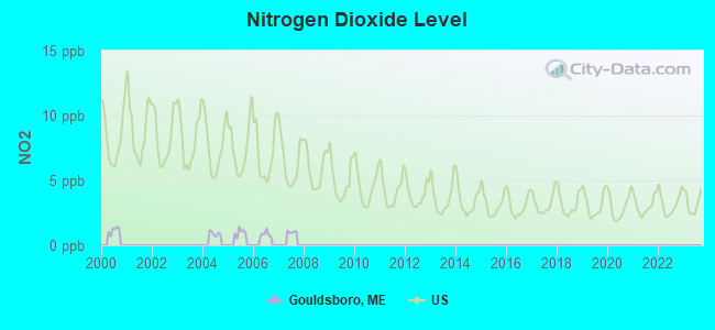
Ozone [ppb] level in 2023 was 36.5. This is about average. Closest monitor was 6.4 miles away from the city center.
| City: | 36.5 |
| U.S.: | 33.3 |
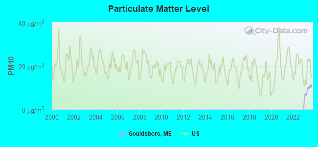
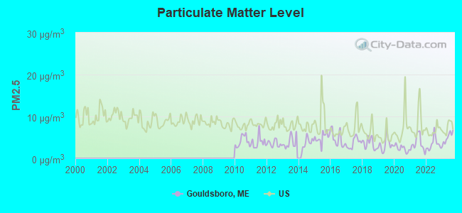
Particulate Matter (PM2.5) [µg/m3] level in 2023 was 4.90. This is significantly better than average. Closest monitor was 11.3 miles away from the city center.
| City: | 4.90 |
| U.S.: | 8.11 |
Earthquake activity:
Gouldsboro-area historical earthquake activity is significantly above Maine state average. It is 81% smaller than the overall U.S. average.On 10/16/2012 at 23:12:25, a magnitude 4.7 (4.7 ML, Depth: 10.0 mi, Class: Light, Intensity: IV - V) earthquake occurred 142.1 miles away from the city center
On 4/20/2002 at 10:50:47, a magnitude 5.3 (5.3 ML, Depth: 3.0 mi, Class: Moderate, Intensity: VI - VII) earthquake occurred 279.1 miles away from Gouldsboro center
On 4/20/2002 at 10:50:47, a magnitude 5.2 (5.2 MB, 4.2 MS, 5.2 MW, 5.0 MW) earthquake occurred 280.1 miles away from the city center
On 1/19/1982 at 00:14:42, a magnitude 4.7 (4.5 MB, 4.7 MD, 4.5 LG) earthquake occurred 188.3 miles away from Gouldsboro center
On 10/7/1983 at 10:18:46, a magnitude 5.3 (5.1 MB, 5.3 LG, 5.1 ML) earthquake occurred 314.0 miles away from Gouldsboro center
On 10/3/2006 at 00:07:38, a magnitude 3.7 (3.7 MD, Depth: 6.2 mi, Class: Light, Intensity: II - III) earthquake occurred 6.7 miles away from the city center
Magnitude types: regional Lg-wave magnitude (LG), body-wave magnitude (MB), duration magnitude (MD), local magnitude (ML), surface-wave magnitude (MS), moment magnitude (MW)
Natural disasters:
The number of natural disasters in Hancock County (18) is near the US average (15).Major Disasters (Presidential) Declared: 11
Emergencies Declared: 6
Causes of natural disasters: Floods: 9, Storms: 8, Snows: 5, Blizzard: 1, Heavy Rain: 1, Hurricane: 1, Ice Storm: 1, Landslide: 1, Snowfall: 1, Wind: 1, Winter Storm: 1, Other: 2 (Note: some incidents may be assigned to more than one category).
Colleges/universities with over 2000 students nearest to Gouldsboro:
- University of Maine (about 45 miles; Orono, ME; Full-time enrollment: 8,931)
- Husson University (about 47 miles; Bangor, ME; FT enrollment: 2,421)
- University of Maine at Augusta (about 87 miles; Augusta, ME; FT enrollment: 3,204)
- University of Maine at Farmington (about 105 miles; Farmington, ME; FT enrollment: 2,036)
- Southern Maine Community College (about 122 miles; South Portland, ME; FT enrollment: 4,666)
- University of Southern Maine (about 124 miles; Portland, ME; FT enrollment: 6,647)
- Saint Joseph's College of Maine (about 129 miles; Standish, ME; FT enrollment: 2,010)
Points of interest:
Notable locations in Gouldsboro: Bartlett Maine Estate Winery (A), Gouldsboro Volunteer Fire Department Station 3 (B), Gouldsboro Volunteer Fire Department Station 1 (C), Gouldsboro Volunteer Fire Department Station 2 (D). Display/hide their locations on the map
Churches in Gouldsboro include: West Gouldsboro Union Church (A), Prospect Harbor United Methodist Church (B), Gouldsboro United Methodist Church (C). Display/hide their locations on the map
Cemeteries: Corea Cemetery (1), Hillcrest Cemetery (2), Hillside Cemetery (3). Display/hide their locations on the map
Lakes, reservoirs, and swamps: Upper Pond (A), Chicken Millpond (B), Forbes Pond (C), Lily Pond (D), Jones Pond (E), Lower West Bay Pond (F), Little Pond (G), Dingle Meadow Heath (H). Display/hide their locations on the map
Streams, rivers, and creeks: Tucker Creek (A), Whitten Parritt Stream (B), Libby Brook (C), Nails Brook (D), Chicken Mill Stream (E), Dike Brook (F). Display/hide their locations on the map
| This town: | 2.2 people |
| Maine: | 2.3 people |
| This town: | 68.3% |
| Whole state: | 62.9% |
| This town: | 8.2% |
| Whole state: | 9.4% |
Likely homosexual households (counted as self-reported same-sex unmarried-partner households)
- Lesbian couples: 1.0% of all households
- Gay men: 0.1% of all households
| This town: | 10.4% |
| Whole state: | 10.9% |
| This town: | 2.5% |
| Whole state: | 4.1% |
For population 15 years and over in Gouldsboro:
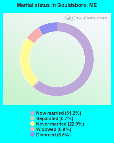
- Never married: 22.9%
- Now married: 61.2%
- Separated: 0.7%
- Widowed: 6.8%
- Divorced: 8.5%
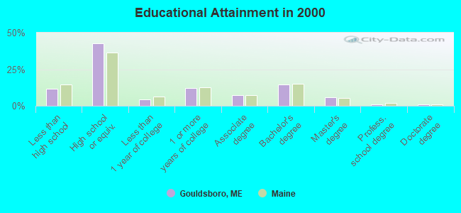
For population 25 years and over in Gouldsboro:
- High school or higher: 88.6%
- Bachelor's degree or higher: 22.3%
- Graduate or professional degree: 7.7%
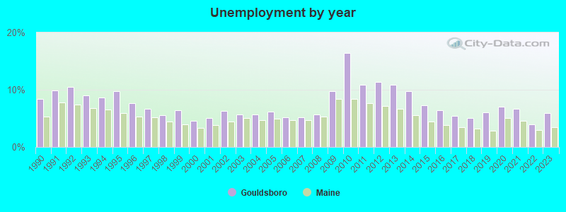
- Unemployed: 3.9%
- Mean travel time to work (commute): 23.7 minutes

| Here: | 9.9 |
| Maine average: | 11.2 |


Graphs represent county-level data. Detailed 2008 Election Results
Religion statistics for Gouldsboro, ME (based on Hancock County data)


| Religion | Adherents | Congregations |
|---|---|---|
| Mainline Protestant | 4,691 | 58 |
| Catholic | 2,523 | 9 |
| Evangelical Protestant | 1,288 | 23 |
| Other | 820 | 11 |
| None | 45,096 | - |
Food Environment Statistics:
| Hancock County: | 6.01 / 10,000 pop. |
| Maine: | 2.80 / 10,000 pop. |
| This county: | 1.69 / 10,000 pop. |
| Maine: | 2.20 / 10,000 pop. |
| This county: | 4.89 / 10,000 pop. |
| Maine: | 5.75 / 10,000 pop. |
| Hancock County: | 21.61 / 10,000 pop. |
| State: | 11.02 / 10,000 pop. |
| This county: | 7.4% |
| Maine: | 8.2% |
| This county: | 25.4% |
| Maine: | 25.0% |
Strongest AM radio stations in Gouldsboro:
- WDEA (1370 AM; 5 kW; ELLSWORTH, ME; Owner: CUMULUS LICENSING CORP.)
- WZON (620 AM; 5 kW; BANGOR, ME; Owner: THE ZONE CORPORATION)
- WABI (910 AM; 5 kW; BANGOR, ME; Owner: CLEAR CHANNEL BROADCASTING LICENSES, INC.)
- WRKO (680 AM; 50 kW; BOSTON, MA; Owner: ENTERCOM BOSTON LICENSE, LLC)
- WSKW (1160 AM; 10 kW; SKOWHEGAN, ME; Owner: MOUNTAIN WIRELESS, INCORPORATED)
- WEEI (850 AM; 50 kW; BOSTON, MA; Owner: ENTERCOM BOSTON LICENSE, LLC)
- WBZ (1030 AM; 50 kW; BOSTON, MA; Owner: INFINITY BROADCASTING OPERATIONS, INC.)
- WCRN (830 AM; 50 kW; WORCESTER, MA; Owner: CARTER BROADCASTING CORPORATION)
- WNNZ (640 AM; 50 kW; WESTFIELD, MA; Owner: CLEAR CHANNEL BROADCASTING LICENSES, INC.)
- WTME (780 AM; 10 kW; RUMFORD, ME; Owner: MOUNTAIN VALLEY BROADCASTING, INC.)
- WKOX (1200 AM; 50 kW; FRAMINGHAM, MA; Owner: CAPSTAR TX LIMITED PARTNERSHIP)
- WALE (990 AM; 50 kW; GREENVILLE, RI; Owner: NORTH AMERICAN BROADCASTING CO., INC.)
- WWZN (1510 AM; 50 kW; BOSTON, MA; Owner: ROSE CITY RADIO CORPORATION)
Strongest FM radio stations in Gouldsboro:
- WNSX (97.7 FM; WINTER HARBOR, ME; Owner: CLEAR CHANNEL BROADCASTING LICENSES, INC.)
- WBQI (107.7 FM; BAR HARBOR, ME; Owner: MARINER BROADCASTING, L.P.)
- WLKE (99.1 FM; BAR HARBOR, ME; Owner: CLEAR CHANNEL BROADCASTING LICENSES, INC.)
- WERU-FM (89.9 FM; BLUE HILL, ME; Owner: SALT POND COMMUNITY B/C COMPANY)
- WWMJ (95.7 FM; ELLSWORTH, ME; Owner: CUMULUS LICENSING CORP.)
- WHCF (88.5 FM; BANGOR, ME; Owner: BANGOR BAPTIST CHURCH)
- WMEH (90.9 FM; BANGOR, ME; Owner: MAINE PUBLIC BROADCASTING CORPORATION)
- WBFB (104.7 FM; BELFAST, ME; Owner: CLEAR CHANNEL BROADCASTING LICENSES, INC.)
- WEZQ (92.9 FM; BANGOR, ME; Owner: CUMULUS LICENSING CORP.)
- WFZX (101.7 FM; SEARSPORT, ME; Owner: CLEAR CHANNEL BROADCASTING LICENSES, INC.)
- WKIT-FM (100.3 FM; BREWER, ME; Owner: THE ZONE CORPORATION)
- Gouldsboro, Maine
- Fatal accident count12
- Vehicles involved in fatal accidents20
- Fatal accidents involving drunk persons:3
- Fatalities15
- Persons involved in fatal accidents43
- Pedestrians involved in fatal accidents1
- Maine average
- Fatal accident count1881
- Vehicles involved in fatal accidents2696
- Fatal accidents involving drunk persons696
- Fatalities2081
- Persons involved in fatal accidents4567
- Pedestrians involved in fatal accidents133
- National Bridge Inventory (NBI) Statistics
- 2Number of bridges
- 13ft / 3.8mTotal length
- 1,504Total average daily traffic
- 75Total average daily truck traffic
- 1,008Total future (year 2036) average daily traffic
FCC Registered Cell Phone Towers:
1 (See the full list of FCC Registered Cell Phone Towers in Gouldsboro)FCC Registered Antenna Towers:
39 (See the full list of FCC Registered Antenna Towers)FCC Registered Microwave Towers:
1- GOULDSBORO, 2 Mi Se (Lat: 44.458389 Lon: -68.103083), Type: Gtower, Structure height: 91.4 m, Overall height: 95.4 m, Call Sign: WML584,
Assigned Frequencies: 6745.00 MHz, Grant Date: 12/28/2010, Expiration Date: 02/01/2021, Cancellation Date: 02/25/2020, Certifier: John E Rooney, Registrant: Holland & Knight LLP, 800 17th Street, N.W., Suite 1100, Washington, DC 20006-3906, Phone: (202) 955-3000, Fax: (202) 955-5564, Email:
FCC Registered Amateur Radio Licenses:
16 (See the full list of FCC Registered Amateur Radio Licenses in Gouldsboro)FAA Registered Aircraft:
3- Aircraft: TIMMS DOUGLASS GLASAIR (Category: Land, Seats: 2, Weight: Up to 12,499 Pounds), Engine: LYCOMING 0-320 SERIES (180 HP) (Reciprocating)
N-Number: 403DT, N403DT, N-403DT, Serial Number: DT-001, Year manufactured: 1991, Airworthiness Date: 04/04/1991, Certificate Issue Date: 05/22/2000
Registrant (Individual): Douglass D Timms, 31 Grange Rd, Gouldsboro, ME 04607 - Aircraft: PIPER J3C-65 (Category: Land, Seats: 2, Weight: Up to 12,499 Pounds, Speed: 67 mph), Engine: CONT MOTOR A&C65 SERIES (65 HP) (Reciprocating)
N-Number: 42571, N42571, N-42571, Serial Number: 14852, Year manufactured: 1945, Airworthiness Date: 05/31/1960, Certificate Issue Date: 02/07/2017
Registrant (Individual): Betty L Sawyer, 43 Taft Point Rd, Gouldsboro, ME 04607 - Aircraft: WARREN J CLOSE SEAREY (Category: Land, Seats: 2, Weight: Up to 12,499 Pounds), Engine: ROTAX 912UL2 (80 HP) (4 Cycle)
N-Number: 841PC, N841PC, N-841PC, Serial Number: 1MK438C, Year manufactured: 2012, Airworthiness Date: 04/24/2012, Certificate Issue Date: 02/24/2012
Registrant (Individual): Warren J Close, Po Box 247, Gouldsboro, ME 04607
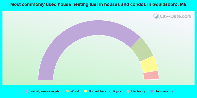
- 74.8%Fuel oil, kerosene, etc.
- 11.9%Wood
- 8.2%Bottled, tank, or LP gas
- 4.8%Electricity
- 0.3%Solar energy
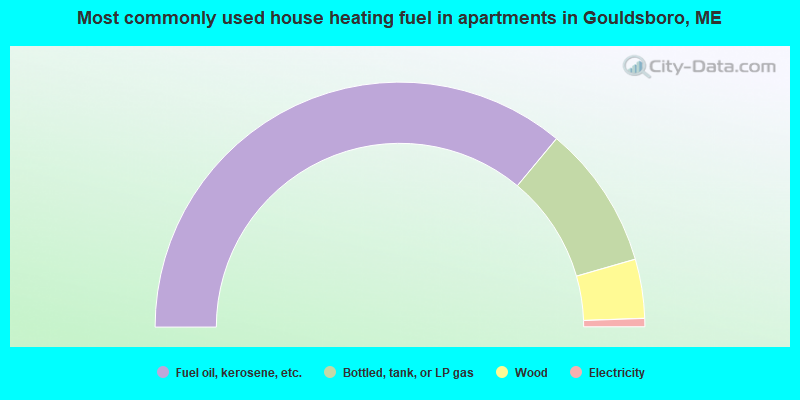
- 72.1%Fuel oil, kerosene, etc.
- 19.0%Bottled, tank, or LP gas
- 7.8%Wood
- 1.1%Electricity
Gouldsboro compared to Maine state average:
- Unemployed percentage significantly below state average.
- Black race population percentage significantly below state average.
- Median age above state average.
- Foreign-born population percentage significantly below state average.
- Renting percentage below state average.
- Length of stay since moving in significantly above state average.
- Number of rooms per house significantly below state average.
- House age significantly below state average.
Gouldsboro on our top lists:
- #89 on the list of "Top 101 cities with the largest percentage of people in military barracks, etc. (population 1,000+)"
- #3 on the list of "Top 101 counties with the lowest Particulate Matter (PM10) Annual air pollution readings in 2012 (µg/m3)"
- #18 on the list of "Top 101 counties with the lowest Particulate Matter (PM2.5) Annual air pollution readings in 2012 (µg/m3)"
- #30 on the list of "Top 101 counties with the lowest Sulfur Oxides Annual air pollution readings in 2012 (µg/m3)"
- #60 on the list of "Top 101 counties with the highest carbon monoxide air pollution readings in 2012 (ppm)"
- #83 on the list of "Top 101 counties with the lowest total withdrawal of fresh water for public supply (pop. 50,000+)"

|
Total of 2 patent applications in 2008-2024.