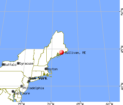
Sullivan, Maine

Sullivan: July 2007 Flanders Pond, Sullivan
Sullivan: Acadia Post & Beam, Sullivan, Maine

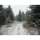
Sullivan: view of cadilac mountain from my house lot now on the market in the great city of sullivan maine
- add
your
Submit your own pictures of this town and show them to the world
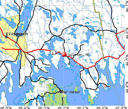
- OSM Map
- General Map
- Google Map
- MSN Map
Population change since 2000: +4.3%
 |
| Males: 603 | |
| Females: 633 |
| Median resident age: | 44.7 years |
| Maine median age: | 43.0 years |
Zip codes: 04607.
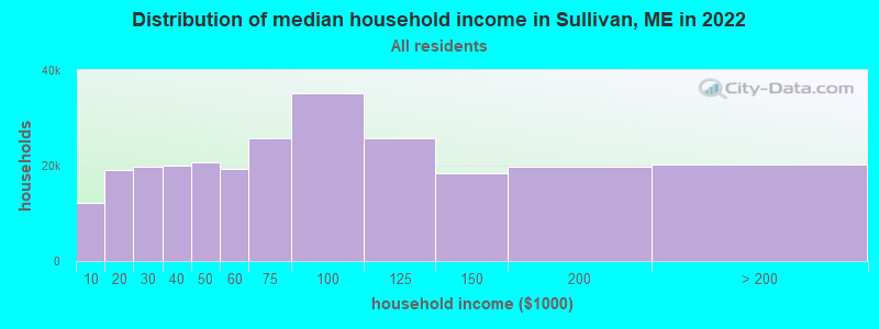
| Sullivan: | $57,511 |
| ME: | $69,543 |
Estimated per capita income in 2022: $30,079 (it was $14,814 in 2000)
Sullivan town income, earnings, and wages data
Estimated median house or condo value in 2022: $223,381 (it was $78,000 in 2000)
| Sullivan: | $223,381 |
| ME: | $290,600 |
Mean prices in 2022: all housing units: $379,336; detached houses: $396,802; townhouses or other attached units: $600,716; in 2-unit structures: $274,479; in 3-to-4-unit structures: $212,346; in 5-or-more-unit structures: $146,369; mobile homes: $158,183; occupied boats, rvs, vans, etc.: $16,454
Detailed information about poverty and poor residents in Sullivan, ME
Compare current foreclosures near Sullivan, ME:
| Photo | Address | Area | Beds / Baths | Price | Details |
|---|---|---|---|---|---|

|
#1
Point Rd
Steuben, ME 04680
|
2,400 sq. feet
|
2 baths 3 beds |
$264,900
|
show details |

|
#2
Earles Way
Hancock, ME 04640
|
- sq. feet
|
- baths - beds |
show details | |

|
#3
Mariaville Rd
Ellsworth, ME 04605
|
- sq. feet
|
- baths - beds |
show details | |

|
Check over 1 million property listings on Foreclosure.com!
|
browse all offers | |||

- 1,18095.5%White alone
- 302.4%Two or more races
- 121.0%Hispanic
- 80.6%American Indian alone
- 40.3%Asian alone
- 20.2%Black alone
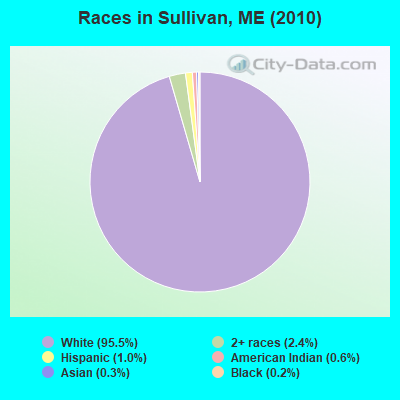
Races in Sullivan detailed stats: ancestries, foreign born residents, place of birth
According to our research of Maine and other state lists, there were 2 registered sex offenders living in Sullivan, Maine as of April 28, 2024.
The ratio of all residents to sex offenders in Sullivan is 618 to 1.
The ratio of registered sex offenders to all residents in this city is near the state average.
 Recent articles from our blog. Our writers, many of them Ph.D. graduates or candidates, create easy-to-read articles on a wide variety of topics.

 | Maine Covid 19 Thread (376 replies) |
| Current Lobster prices (71 replies) |
| Small town Maine retirement (47 replies) |
| Purchased a Franklin, Maine property (43 replies) |
| Considering moving to Maine (10 replies) |
| Rural Maine questions (North or Central) (24 replies) |
Latest news from Sullivan, ME collected exclusively by city-data.com from local newspapers, TV, and radio stations
Ancestries: English (30.5%), Irish (15.8%), United States (15.6%), German (6.8%), French (5.9%), Scottish (5.7%).
Current Local Time: EST time zone
Incorporated on 02/16/1789
Elevation: 81 feet
Land area: 26.6 square miles.
Population density: 46 people per square mile (very low).
22 residents are foreign born
| This town: | 1.9% |
| Maine: | 2.9% |
| Sullivan town: | 1.3% ($1,016) |
| Maine: | 1.5% ($1,417) |
Nearest city with pop. 50,000+: Portland, ME  (121.1 miles , pop. 64,249).
Nearest city with pop. 200,000+: Boston, MA (212.6 miles , pop. 589,141).
Nearest city with pop. 1,000,000+: Bronx, NY (386.7 miles , pop. 1,332,650).
Nearest cities:
Latitude: 44.54 N, Longitude: 68.15 W
Area code: 207

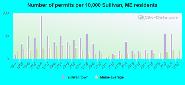
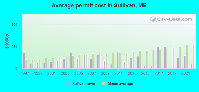
Single-family new house construction building permits:
- 2022: 1 building, cost: $50,000
- 2021: 13 buildings, average cost: $146,200
- 2020: 13 buildings, average cost: $123,100
- 2018: 5 buildings, average cost: $248,100
- 2017: 5 buildings, average cost: $248,100
- 2016: 4 buildings, average cost: $30,800
- 2015: 4 buildings, average cost: $30,800
- 2014: 9 buildings, average cost: $138,900
- 2013: 4 buildings, average cost: $127,000
- 2012: 3 buildings, average cost: $78,700
- 2011: 1 building, cost: $184,700
- 2010: 4 buildings, average cost: $48,800
- 2009: 8 buildings, average cost: $91,200
- 2008: 13 buildings, average cost: $155,800
- 2007: 11 buildings, average cost: $108,100
- 2006: 10 buildings, average cost: $151,300
- 2005: 9 buildings, average cost: $117,400
- 2004: 12 buildings, average cost: $180,000
- 2003: 9 buildings, average cost: $112,200
- 2002: 12 buildings, average cost: $83,800
- 2001: 22 buildings, average cost: $80,000
- 2000: 11 buildings, average cost: $61,900
- 1999: 12 buildings, average cost: $62,500
- 1998: 8 buildings, average cost: $59,400
- 1997: 2 buildings, average cost: $175,000
| Here: | 7.7% |
| Maine: | 3.4% |
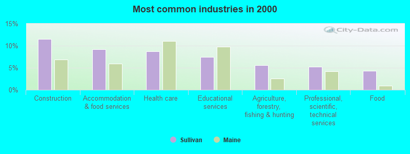
- Construction (11.5%)
- Accommodation & food services (9.2%)
- Health care (8.7%)
- Educational services (7.5%)
- Agriculture, forestry, fishing & hunting (5.6%)
- Professional, scientific, technical services (5.2%)
- Food (4.3%)
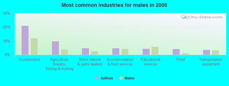
- Construction (21.2%)
- Agriculture, forestry, fishing & hunting (9.9%)
- Motor vehicle & parts dealers (5.0%)
- Accommodation & food services (5.0%)
- Educational services (4.6%)
- Food (4.3%)
- Transportation equipment (3.6%)
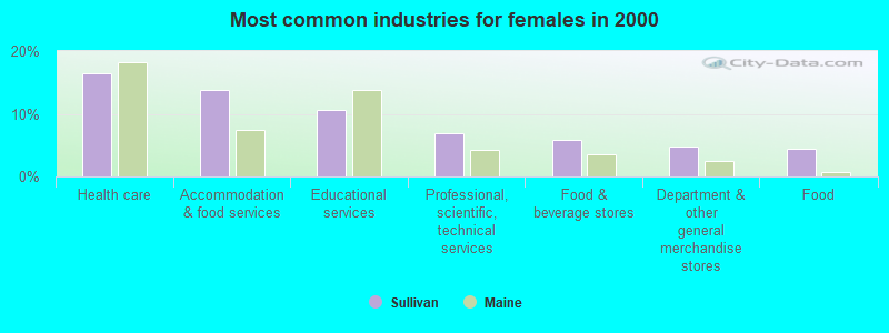
- Health care (16.4%)
- Accommodation & food services (13.9%)
- Educational services (10.6%)
- Professional, scientific, technical services (6.9%)
- Food & beverage stores (5.8%)
- Department & other general merchandise stores (4.7%)
- Food (4.4%)
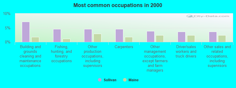
- Building and grounds cleaning and maintenance occupations (7.1%)
- Fishing, hunting, and forestry occupations (4.5%)
- Other production occupations, including supervisors (4.5%)
- Carpenters (4.5%)
- Other management occupations, except farmers and farm managers (3.8%)
- Driver/sales workers and truck drivers (3.6%)
- Other sales and related occupations, including supervisors (3.6%)
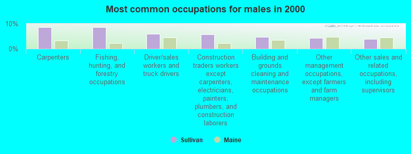
- Carpenters (8.6%)
- Fishing, hunting, and forestry occupations (8.6%)
- Driver/sales workers and truck drivers (6.0%)
- Construction traders workers except carpenters, electricians, painters, plumbers, and construction laborers (5.6%)
- Building and grounds cleaning and maintenance occupations (4.6%)
- Other management occupations, except farmers and farm managers (4.3%)
- Other sales and related occupations, including supervisors (4.0%)
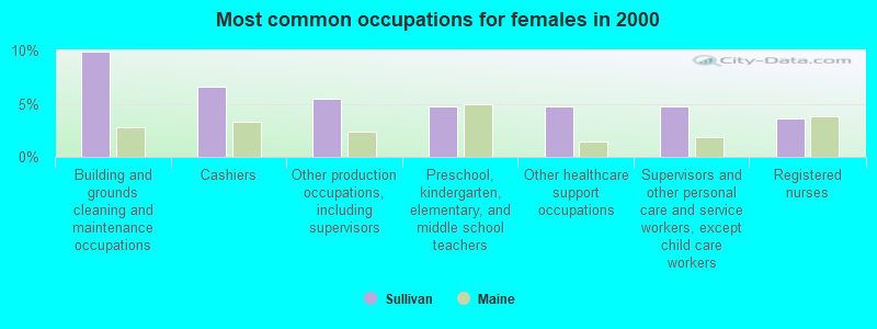
- Building and grounds cleaning and maintenance occupations (9.9%)
- Cashiers (6.6%)
- Other production occupations, including supervisors (5.5%)
- Preschool, kindergarten, elementary, and middle school teachers (4.7%)
- Other healthcare support occupations (4.7%)
- Supervisors and other personal care and service workers, except child care workers (4.7%)
- Registered nurses (3.6%)
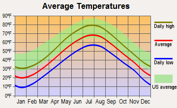
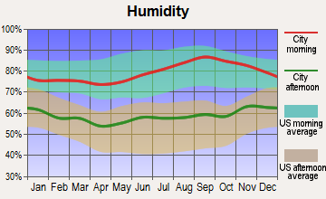
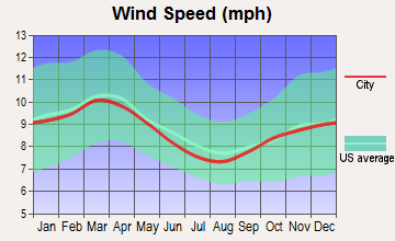
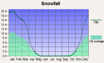
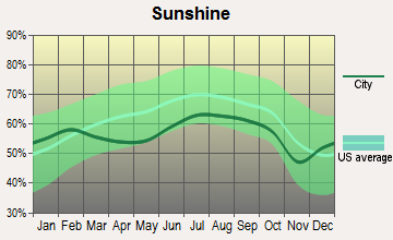
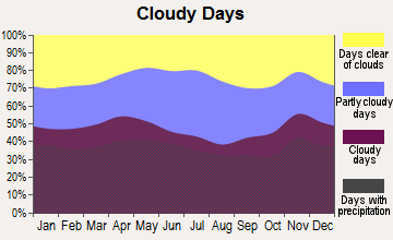
Average climate in Sullivan, Maine
Based on data reported by over 4,000 weather stations
(lower is better)
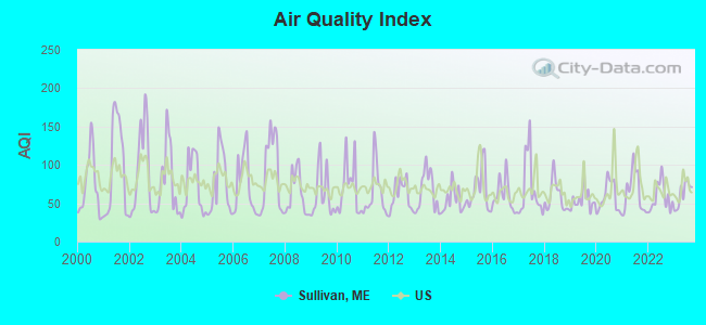
Air Quality Index (AQI) level in 2023 was 61.9. This is about average.
| City: | 61.9 |
| U.S.: | 72.6 |
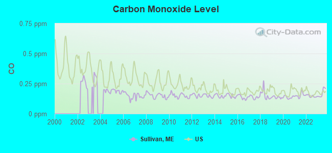
Carbon Monoxide (CO) [ppm] level in 2023 was 0.172. This is significantly better than average. Closest monitor was 12.2 miles away from the city center.
| City: | 0.172 |
| U.S.: | 0.251 |
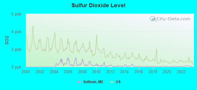
Sulfur Dioxide (SO2) [ppb] level in 2023 was 0.0636. This is significantly better than average. Closest monitor was 12.2 miles away from the city center.
| City: | 0.0636 |
| U.S.: | 1.5147 |
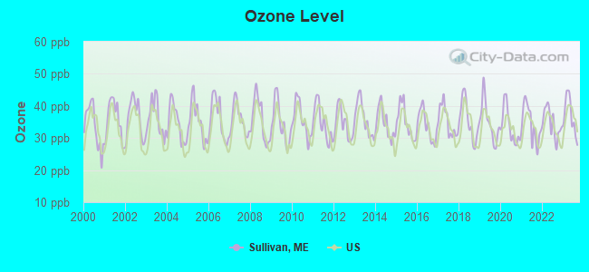
Ozone [ppb] level in 2023 was 36.9. This is about average. Closest monitor was 12.2 miles away from the city center.
| City: | 36.9 |
| U.S.: | 33.3 |
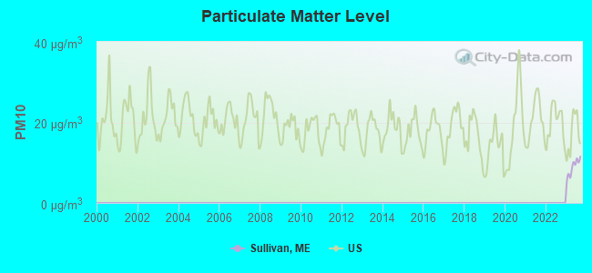
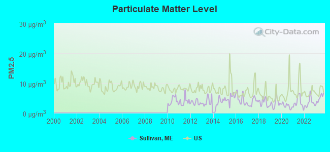
Particulate Matter (PM2.5) [µg/m3] level in 2023 was 4.90. This is significantly better than average. Closest monitor was 12.2 miles away from the city center.
| City: | 4.90 |
| U.S.: | 8.11 |
Earthquake activity:
Sullivan-area historical earthquake activity is significantly above Maine state average. It is 81% smaller than the overall U.S. average.On 10/16/2012 at 23:12:25, a magnitude 4.7 (4.7 ML, Depth: 10.0 mi, Class: Light, Intensity: IV - V) earthquake occurred 140.2 miles away from Sullivan center
On 4/20/2002 at 10:50:47, a magnitude 5.3 (5.3 ML, Depth: 3.0 mi, Class: Moderate, Intensity: VI - VII) earthquake occurred 273.3 miles away from the city center
On 4/20/2002 at 10:50:47, a magnitude 5.2 (5.2 MB, 4.2 MS, 5.2 MW, 5.0 MW) earthquake occurred 274.4 miles away from the city center
On 1/19/1982 at 00:14:42, a magnitude 4.7 (4.5 MB, 4.7 MD, 4.5 LG) earthquake occurred 185.7 miles away from Sullivan center
On 10/7/1983 at 10:18:46, a magnitude 5.3 (5.1 MB, 5.3 LG, 5.1 ML) earthquake occurred 309.1 miles away from Sullivan center
On 10/3/2006 at 00:07:38, a magnitude 3.7 (3.7 MD, Depth: 6.2 mi, Class: Light, Intensity: II - III) earthquake occurred 11.7 miles away from Sullivan center
Magnitude types: regional Lg-wave magnitude (LG), body-wave magnitude (MB), duration magnitude (MD), local magnitude (ML), surface-wave magnitude (MS), moment magnitude (MW)
Natural disasters:
The number of natural disasters in Hancock County (18) is near the US average (15).Major Disasters (Presidential) Declared: 11
Emergencies Declared: 6
Causes of natural disasters: Floods: 9, Storms: 8, Snows: 5, Blizzard: 1, Heavy Rain: 1, Hurricane: 1, Ice Storm: 1, Landslide: 1, Snowfall: 1, Wind: 1, Winter Storm: 1, Other: 2 (Note: some incidents may be assigned to more than one category).

Hospitals and medical centers in Sullivan:
Other hospitals and medical centers near Sullivan:
- SONOGEE ESTATES (Nursing Home, about 11 miles away; BAR HARBOR, ME)
- SONOGEE REHABILITATION AND LIVING CENTER (Nursing Home, about 11 miles away; BAR HARBOR, ME)
- MOUNT DESERT ISLAND HOSPITAL Critical Access Hospitals (about 11 miles away; BAR HARBOR, ME)
- BIRCHWOOD LIVING CENTER (Hospital, about 13 miles away; ELLSWORTH, ME)
- COLLIER'S REHAB AND NURSING CTR (Nursing Home, about 14 miles away; ELLSWORTH, ME)
- COURTLAND REHAB AND LIVING CENTER (Nursing Home, about 14 miles away; ELLSWORTH, ME)
Colleges/universities with over 2000 students nearest to Sullivan:
- University of Maine (about 36 miles; Orono, ME; Full-time enrollment: 8,931)
- Husson University (about 38 miles; Bangor, ME; FT enrollment: 2,421)
- University of Maine at Augusta (about 83 miles; Augusta, ME; FT enrollment: 3,204)
- University of Maine at Farmington (about 99 miles; Farmington, ME; FT enrollment: 2,036)
- Southern Maine Community College (about 120 miles; South Portland, ME; FT enrollment: 4,666)
- University of Southern Maine (about 122 miles; Portland, ME; FT enrollment: 6,647)
- Saint Joseph's College of Maine (about 126 miles; Standish, ME; FT enrollment: 2,010)
Public high school in Sullivan:
- SUMNER MEMORIAL HIGH SCHOOL (Location: 2456 US HWY 1, Grades: 9-12)
Public elementary/middle school in Sullivan:
- MOUNTAIN VIEW SCHOOL (Location: 542 BERT GRAY ROAD, Grades: PK-8)
Points of interest:
Notable locations in Sullivan: Sullivan Harbor Scenic Turnout (A), Mountainview Campground (B), Big Chief Camps (C), Sullivan Volunteer Fire Department East Sullivan Station (D), Sullivan-Sorrento Historical Society Building (E), Sullivan Volunteer Fire Department Barbara Davis Station (F). Display/hide their locations on the map
Churches in Sullivan include: Community Church (A), North Sullivan United Methodist Church (B), Union Church (C), Sullivan Harbor Church (D). Display/hide their locations on the map
Cemeteries: Gordon Cemetery (1), Blaisdell Cemetery (2), Salter Cemetery (3), Doyle Cemetery (4), Dyer Cemetery (5), Simpson Cemetery (6), York Hill Cemetery (7). Display/hide their locations on the map
Lakes, reservoirs, and swamps: Mill Pond (A), Basin Pond (B), Little Tunk Pond (C), Morancy Pond (D), Schoodic Bog (E), Flanders Pond (F), Long Pond (G), Brown Meadow (H). Display/hide their locations on the map
Streams, rivers, and creeks: Smelt Brook (A), Clapham Brook (B), Grays Brook (C), Mill Brook (D), Dry Brook (E), Schoodic Brook (F), Merchants Brook (G), Flanders Stream (H), Morancy Stream (I). Display/hide their locations on the map
Drinking water stations with addresses in Sullivan and their reported violations in the past:
LONG POND WATER DISTRICT (Population served: 383, Surface water):Past health violations:CHESTER PIKES GALLEY (Population served: 250, Groundwater):Past monitoring violations:
- MCL, Average - Between JUL-2010 and SEP-2010, Contaminant: TTHM. Follow-up actions: St Public Notif received (AUG-27-2010), St Public Notif requested (OCT-22-2010), St Formal NOV issued (OCT-22-2010), St Compliance achieved (NOV-13-2011)
- Treatment Technique (SWTR and GWR) - In APR-2010. Follow-up actions: St Public Notif requested (MAY-18-2010), St Formal NOV issued (MAY-18-2010), St Public Notif received (JUN-07-2010), St Compliance achieved (MAR-29-2011)
- Treatment Technique (SWTR and GWR) - In OCT-2008. Follow-up actions: St Public Notif requested (JAN-27-2009), St Formal NOV issued (JAN-27-2009), St Public Notif received (MAR-04-2009), St Compliance achieved (APR-30-2009)
- Treatment Technique (SWTR and GWR) - In SEP-2008. Follow-up actions: St Public Notif requested (JAN-27-2009), St Formal NOV issued (JAN-27-2009), St Public Notif received (MAR-04-2009), St Compliance achieved (APR-30-2009)
- Treatment Technique (SWTR and GWR) - In JUN-2008. Follow-up actions: St Public Notif requested (AUG-13-2008), St Formal NOV issued (AUG-13-2008), St Compliance achieved (APR-30-2009), St Intentional no-action (SEP-15-2011)
- MCL, Average - Between JAN-2007 and MAR-2007, Contaminant: TTHM. Follow-up actions: St Public Notif requested (MAY-16-2007), St Violation/Reminder Notice (MAY-16-2007), St Public Notif received (JUN-26-2008), St Compliance achieved (APR-30-2009)
- 5 other older health violations
- Monitoring of Treatment (SWTR-Filter) - In NOV-2008. Follow-up actions: St Public Notif requested (APR-06-2009), St Formal NOV issued (APR-06-2009), St Public Notif received (APR-29-2009), St Compliance achieved (APR-30-2009)
- Monitoring of Treatment (SWTR-Filter) - In OCT-2008. Follow-up actions: St Public Notif requested (APR-06-2009), St Formal NOV issued (APR-06-2009), St Public Notif received (APR-29-2009), St Compliance achieved (APR-30-2009)
- Monitoring of Treatment (SWTR-Filter) - In SEP-2008. Follow-up actions: St Public Notif requested (APR-06-2009), St Formal NOV issued (APR-06-2009), St Public Notif received (APR-29-2009), St Compliance achieved (APR-30-2009)
- Monitoring of Treatment (SWTR-Filter) - In AUG-2008. Follow-up actions: St Public Notif requested (APR-06-2009), St Formal NOV issued (APR-06-2009), St Public Notif received (APR-29-2009), St Compliance achieved (APR-30-2009)
- Monitoring of Treatment (SWTR-Filter) - In JUL-2008. Follow-up actions: St Public Notif requested (APR-06-2009), St Formal NOV issued (APR-06-2009), St Public Notif received (APR-29-2009), St Compliance achieved (APR-30-2009)
- One routine major monitoring violation
- 2 other older monitoring violations
Past monitoring violations:MOUNTAINVIEW CAMPGROUND (Population served: 125, Groundwater):
- 8 routine major monitoring violations
- One minor monitoring violation
- 4 regular monitoring violations
Past monitoring violations:THE GALLEY RESTAURANT (Population served: 120, Groundwater):
- One routine major monitoring violation
- One regular monitoring violation
Past health violations:SULLIVAN TOWN OFFICE (Population served: 35, Groundwater):Past monitoring violations:
- MCL, Monthly (TCR) - In JUL-2013, Contaminant: Coliform. Follow-up actions: St Public Notif requested (JUL-16-2013), St Formal NOV issued (JUL-16-2013), St Compliance achieved (AUG-21-2013), St Site Visit (enforcement) (MAY-28-2014), St Public Notif received (JUN-27-2014)
- 8 routine major monitoring violations
- 9 regular monitoring violations
Past monitoring violations:SORRENTO/SULLIVAN REC CENTER (Population served: 25, Groundwater):
- One routine major monitoring violation
Past health violations:Past monitoring violations:
- MCL, Monthly (TCR) - In DEC-2010, Contaminant: Coliform. Follow-up actions: St Public Notif requested (DEC-21-2010), St Formal NOV issued (DEC-21-2010), St Public Notif received (MAR-27-2012), St Compliance achieved (APR-05-2012)
- MCL, Monthly (TCR) - In AUG-2005, Contaminant: Coliform. Follow-up actions: St Public Notif requested (SEP-01-2005), St Violation/Reminder Notice (SEP-01-2005), St Public Notif received (2 times from SEP-22-2005 to SEP-22-2005), St Compliance achieved (MAY-19-2006)
- MCL, Monthly (TCR) - In JUL-2005, Contaminant: Coliform. Follow-up actions: St Public Notif requested (AUG-05-2005), St Violation/Reminder Notice (AUG-05-2005), St Public Notif received (2 times from AUG-25-2005 to AUG-25-2005), St Compliance achieved (MAY-19-2006)
- 2 routine major monitoring violations
Drinking water stations with addresses in Sullivan that have no violations reported:
- RSU 24 PENINSULA ELEMENTARY SCHOOL (Population served: 220, Primary Water Source Type: Groundwater)
| This town: | 2.3 people |
| Maine: | 2.3 people |
| This town: | 62.9% |
| Whole state: | 62.9% |
| This town: | 13.8% |
| Whole state: | 9.4% |
Likely homosexual households (counted as self-reported same-sex unmarried-partner households)
- Lesbian couples: 0.9% of all households
- Gay men: 1.1% of all households
| This town: | 13.6% |
| Whole state: | 10.9% |
| This town: | 3.0% |
| Whole state: | 4.1% |
For population 15 years and over in Sullivan:
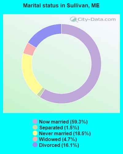
- Never married: 18.5%
- Now married: 59.3%
- Separated: 1.5%
- Widowed: 4.7%
- Divorced: 16.1%
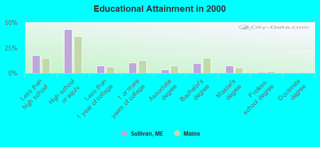
For population 25 years and over in Sullivan:
- High school or higher: 82.4%
- Bachelor's degree or higher: 18.2%
- Graduate or professional degree: 8.3%
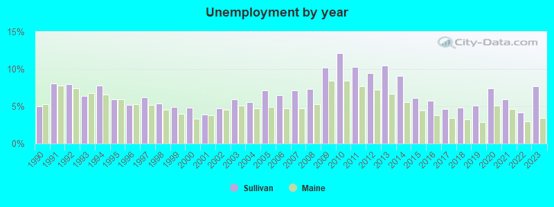
- Unemployed: 4.6%
- Mean travel time to work (commute): 28.4 minutes
| Here: | 10.5 |
| Maine average: | 11.2 |


Graphs represent county-level data. Detailed 2008 Election Results
Religion statistics for Sullivan, ME (based on Hancock County data)


| Religion | Adherents | Congregations |
|---|---|---|
| Mainline Protestant | 4,691 | 58 |
| Catholic | 2,523 | 9 |
| Evangelical Protestant | 1,288 | 23 |
| Other | 820 | 11 |
| None | 45,096 | - |
Food Environment Statistics:
| Hancock County: | 6.01 / 10,000 pop. |
| Maine: | 2.80 / 10,000 pop. |
| Hancock County: | 1.69 / 10,000 pop. |
| Maine: | 2.20 / 10,000 pop. |
| Here: | 4.89 / 10,000 pop. |
| State: | 5.75 / 10,000 pop. |
| Hancock County: | 21.61 / 10,000 pop. |
| Maine: | 11.02 / 10,000 pop. |
| Hancock County: | 7.4% |
| Maine: | 8.2% |
| This county: | 25.4% |
| Maine: | 25.0% |
Strongest AM radio stations in Sullivan:
- WDEA (1370 AM; 5 kW; ELLSWORTH, ME; Owner: CUMULUS LICENSING CORP.)
- WZON (620 AM; 5 kW; BANGOR, ME; Owner: THE ZONE CORPORATION)
- WABI (910 AM; 5 kW; BANGOR, ME; Owner: CLEAR CHANNEL BROADCASTING LICENSES, INC.)
- WRKO (680 AM; 50 kW; BOSTON, MA; Owner: ENTERCOM BOSTON LICENSE, LLC)
- WSKW (1160 AM; 10 kW; SKOWHEGAN, ME; Owner: MOUNTAIN WIRELESS, INCORPORATED)
- WEEI (850 AM; 50 kW; BOSTON, MA; Owner: ENTERCOM BOSTON LICENSE, LLC)
- WBZ (1030 AM; 50 kW; BOSTON, MA; Owner: INFINITY BROADCASTING OPERATIONS, INC.)
- WCRN (830 AM; 50 kW; WORCESTER, MA; Owner: CARTER BROADCASTING CORPORATION)
- WNNZ (640 AM; 50 kW; WESTFIELD, MA; Owner: CLEAR CHANNEL BROADCASTING LICENSES, INC.)
- WTME (780 AM; 10 kW; RUMFORD, ME; Owner: MOUNTAIN VALLEY BROADCASTING, INC.)
- WKOX (1200 AM; 50 kW; FRAMINGHAM, MA; Owner: CAPSTAR TX LIMITED PARTNERSHIP)
- WALE (990 AM; 50 kW; GREENVILLE, RI; Owner: NORTH AMERICAN BROADCASTING CO., INC.)
- WWZN (1510 AM; 50 kW; BOSTON, MA; Owner: ROSE CITY RADIO CORPORATION)
Strongest FM radio stations in Sullivan:
- WNSX (97.7 FM; WINTER HARBOR, ME; Owner: CLEAR CHANNEL BROADCASTING LICENSES, INC.)
- WBQI (107.7 FM; BAR HARBOR, ME; Owner: MARINER BROADCASTING, L.P.)
- WLKE (99.1 FM; BAR HARBOR, ME; Owner: CLEAR CHANNEL BROADCASTING LICENSES, INC.)
- WWMJ (95.7 FM; ELLSWORTH, ME; Owner: CUMULUS LICENSING CORP.)
- WERU-FM (89.9 FM; BLUE HILL, ME; Owner: SALT POND COMMUNITY B/C COMPANY)
- WMEH (90.9 FM; BANGOR, ME; Owner: MAINE PUBLIC BROADCASTING CORPORATION)
- WHCF (88.5 FM; BANGOR, ME; Owner: BANGOR BAPTIST CHURCH)
- WEZQ (92.9 FM; BANGOR, ME; Owner: CUMULUS LICENSING CORP.)
- WKIT-FM (100.3 FM; BREWER, ME; Owner: THE ZONE CORPORATION)
- WBFB (104.7 FM; BELFAST, ME; Owner: CLEAR CHANNEL BROADCASTING LICENSES, INC.)
- WVOM (103.9 FM; HOWLAND, ME; Owner: CLEAR CHANNEL BROADCASTING LICENSES, INC.)
- WFZX (101.7 FM; SEARSPORT, ME; Owner: CLEAR CHANNEL BROADCASTING LICENSES, INC.)
- WWBX (97.1 FM; BANGOR, ME; Owner: CLEAR CHANNEL BROADCASTING LICENSES, INC.)
TV broadcast stations around Sullivan:
- WMEB-TV (Channel 12; ORONO, ME; Owner: MAINE PUBLIC BROADCASTING CORPORATION)
- Sullivan, Maine
- Fatal accident count16
- Vehicles involved in fatal accidents24
- Fatal accidents involving drunk persons:6
- Fatalities18
- Persons involved in fatal accidents35
- Pedestrians involved in fatal accidents0
- Maine average
- Fatal accident count2643
- Vehicles involved in fatal accidents3748
- Fatal accidents involving drunk persons1043
- Fatalities2914
- Persons involved in fatal accidents6298
- Pedestrians involved in fatal accidents160
- National Bridge Inventory (NBI) Statistics
- 1Number of bridges
- 3ft / 0.7mTotal length
- 6,480Total average daily traffic
- 324Total average daily truck traffic
- 9,072Total future (year 2036) average daily traffic
FCC Registered Antenna Towers:
9 (See the full list of FCC Registered Antenna Towers in Sullivan)FCC Registered Broadcast Land Mobile Towers:
1- Lat: 44.519806 Lon: -68.166389, Call Sign: WPPD422,
Assigned Frequencies: 458.000 MHz, 152.345 MHz, 152.375 MHz, Grant Date: 08/12/2014, Expiration Date: 10/29/2024, Certifier: Sally Leighton, Registrant: Browns Communications, 162 Bangor Rd, Ellsworth, ME 04901, Phone: (207) 667-2254, Email:
FCC Registered Microwave Towers:
1- TARPON SPRIN, Overtaxed Lane (Lat: 44.497389 Lon: -68.141167), Type: Ltower, Structure height: 57.9 m, Call Sign: WRAK611,
Assigned Frequencies: 11245.0 MHz, 11245.0 MHz, 11245.0 MHz, 11245.0 MHz, 11245.0 MHz, 11245.0 MHz, 11245.0 MHz, 11245.0 MHz, 11245.0 MHz, 11245.0 MHz... (+10 more), Grant Date: 12/15/2017, Expiration Date: 12/15/2027, Certifier: Madeleine Braun, Registrant: The Jackson Laboratory, 600 Main Street, Bar Harbor, ME 04609, Phone: (207) 288-6004, Email:
FCC Registered Amateur Radio Licenses:
10 (See the full list of FCC Registered Amateur Radio Licenses in Sullivan)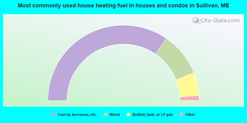
- 69.1%Fuel oil, kerosene, etc.
- 18.8%Wood
- 9.9%Bottled, tank, or LP gas
- 1.6%Electricity
- 0.5%Other fuel
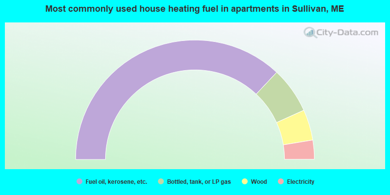
- 74.0%Fuel oil, kerosene, etc.
- 12.5%Bottled, tank, or LP gas
- 8.3%Wood
- 5.2%Electricity
Sullivan compared to Maine state average:
- Unemployed percentage below state average.
- Black race population percentage significantly below state average.
- Hispanic race population percentage below state average.
- Foreign-born population percentage below state average.
- Length of stay since moving in significantly above state average.
- Number of rooms per house significantly below state average.
- House age significantly below state average.
- Number of college students below state average.

|
Total of 5 patent applications in 2008-2024.