Sorrento, Maine

Sorrento: giant icicle formed by a roadside pipe spraying upwards

Sorrento: Sorrento Night
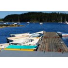
Sorrento: Sorrento Docks

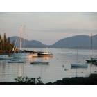
Sorrento: Sorrento at Dusk

Sorrento: Spectacular view along Ocean Ave taken in early August

Sorrento: Sunset from Bayview Avenue
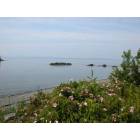
Sorrento: Ocean Avenue Rugosa Roses in Morning Mist
Sorrento: Sorrento Harbor
- add
your
Submit your own pictures of this town and show them to the world
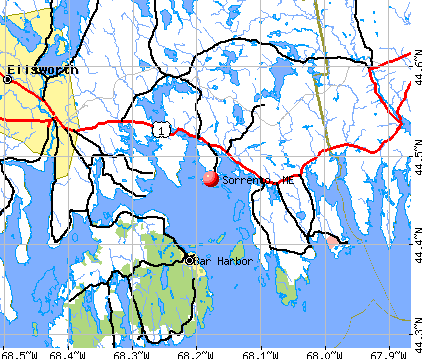
- OSM Map
- General Map
- Google Map
- MSN Map
Population change since 2000: -5.5%
 |
| Males: 135 | |
| Females: 139 |
| Median resident age: | 52.5 years |
| Maine median age: | 43.0 years |
Zip codes: 04677.
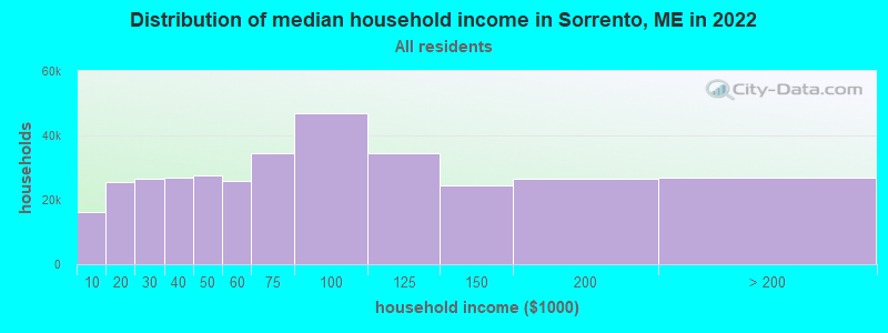
| Sorrento: | $76,888 |
| ME: | $69,543 |
Estimated per capita income in 2022: $48,306 (it was $23,791 in 2000)
Sorrento town income, earnings, and wages data
Estimated median house or condo value in 2022: $345,954 (it was $120,800 in 2000)
| Sorrento: | $345,954 |
| ME: | $290,600 |
Mean prices in 2022: all housing units: $379,336; detached houses: $396,802; townhouses or other attached units: $600,716; in 2-unit structures: $274,479; in 3-to-4-unit structures: $212,346; in 5-or-more-unit structures: $146,369; mobile homes: $158,183; occupied boats, rvs, vans, etc.: $16,454
Detailed information about poverty and poor residents in Sorrento, ME


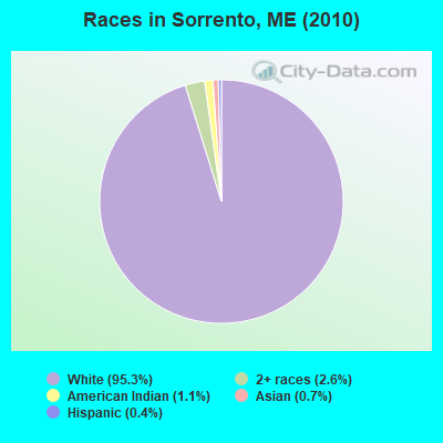
- 26195.3%White alone
- 72.6%Two or more races
- 31.1%American Indian alone
- 20.7%Asian alone
- 10.4%Hispanic
Races in Sorrento detailed stats: ancestries, foreign born residents, place of birth
According to our research of Maine and other state lists, there was 1 registered sex offender living in Sorrento, Maine as of April 28, 2024.
The ratio of all residents to sex offenders in Sorrento is 274 to 1.
 Recent articles from our blog. Our writers, many of them Ph.D. graduates or candidates, create easy-to-read articles on a wide variety of topics.

 | Coastal artsy towns? (15 replies) |
| Low Temperatures (99 replies) |
| Moving to Searsport, ME (37 replies) |
| Want Maine? Fill this out. (141 replies) |
| Maine School District Consolidation (48 replies) |
| How much are Mainers paying for groceries? (71 replies) |
Latest news from Sorrento, ME collected exclusively by city-data.com from local newspapers, TV, and radio stations
Sorrento, ME City Guides:
Ancestries: English (36.9%), Irish (19.3%), German (8.6%), French (6.6%), United States (5.2%), Scottish (4.5%).
Current Local Time: EST time zone
Incorporated on 03/03/1895
Elevation: 57 feet
Land area: 3.99 square miles.
Population density: 69 people per square mile (very low).
3 residents are foreign born
| This town: | 1.0% |
| Maine: | 2.9% |
| Sorrento town: | 0.9% ($1,063) |
| Maine: | 1.5% ($1,417) |
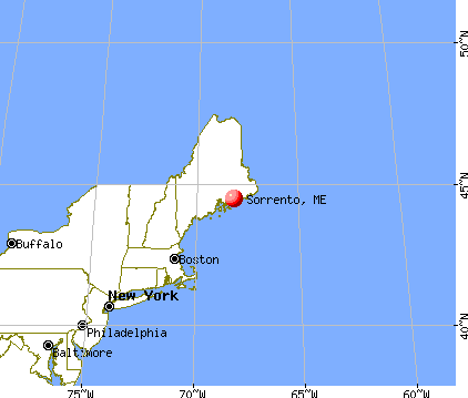
Nearest city with pop. 50,000+: Portland, ME  (118.1 miles , pop. 64,249).
Nearest city with pop. 200,000+: Boston, MA (209.0 miles , pop. 589,141).
Nearest city with pop. 1,000,000+: Bronx, NY (383.3 miles , pop. 1,332,650).
Nearest cities:
)Latitude: 44.48 N, Longitude: 68.18 W
Area code commonly used in this area: 207

| Here: | 2.6% |
| Maine: | 3.4% |
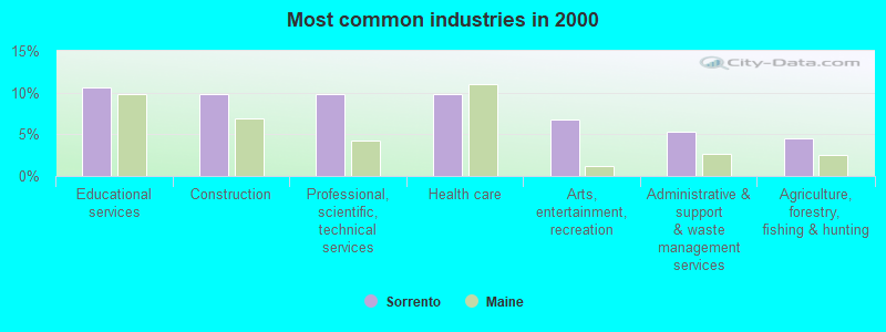
- Educational services (10.6%)
- Construction (9.8%)
- Professional, scientific, technical services (9.8%)
- Health care (9.8%)
- Arts, entertainment, recreation (6.8%)
- Administrative & support & waste management services (5.3%)
- Agriculture, forestry, fishing & hunting (4.5%)
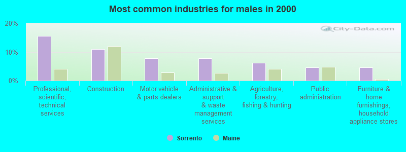
- Professional, scientific, technical services (15.6%)
- Construction (10.9%)
- Motor vehicle & parts dealers (7.8%)
- Administrative & support & waste management services (7.8%)
- Agriculture, forestry, fishing & hunting (6.2%)
- Public administration (4.7%)
- Furniture & home furnishings, household appliance stores (4.7%)
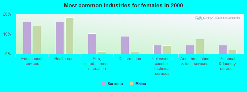
- Educational services (16.2%)
- Health care (16.2%)
- Arts, entertainment, recreation (10.3%)
- Construction (8.8%)
- Professional, scientific, technical services (4.4%)
- Accommodation & food services (4.4%)
- Personal & laundry services (4.4%)
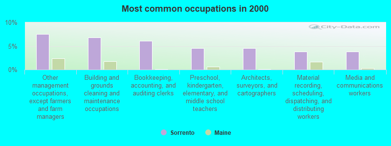
- Other management occupations, except farmers and farm managers (7.6%)
- Building and grounds cleaning and maintenance occupations (6.8%)
- Bookkeeping, accounting, and auditing clerks (6.1%)
- Preschool, kindergarten, elementary, and middle school teachers (4.5%)
- Architects, surveyors, and cartographers (4.5%)
- Material recording, scheduling, dispatching, and distributing workers (3.8%)
- Media and communications workers (3.8%)

- Building and grounds cleaning and maintenance occupations (10.9%)
- Architects, surveyors, and cartographers (9.4%)
- Carpenters (7.8%)
- Other protective service workers, including supervisors (6.2%)
- Art and design workers (6.2%)
- Fishing, hunting, and forestry occupations (6.2%)
- Driver/sales workers and truck drivers (6.2%)
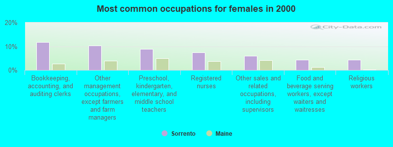
- Bookkeeping, accounting, and auditing clerks (11.8%)
- Other management occupations, except farmers and farm managers (10.3%)
- Preschool, kindergarten, elementary, and middle school teachers (8.8%)
- Registered nurses (7.4%)
- Other sales and related occupations, including supervisors (5.9%)
- Food and beverage serving workers, except waiters and waitresses (4.4%)
- Religious workers (4.4%)
Average climate in Sorrento, Maine
Based on data reported by over 4,000 weather stations


(lower is better)
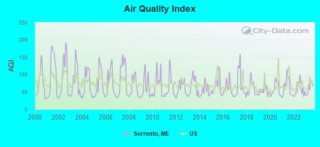
Air Quality Index (AQI) level in 2023 was 61.9. This is about average.
| City: | 61.9 |
| U.S.: | 72.6 |
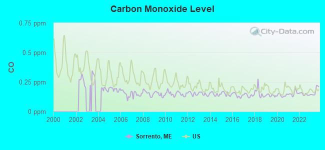
Carbon Monoxide (CO) [ppm] level in 2023 was 0.172. This is significantly better than average. Closest monitor was 8.3 miles away from the city center.
| City: | 0.172 |
| U.S.: | 0.251 |
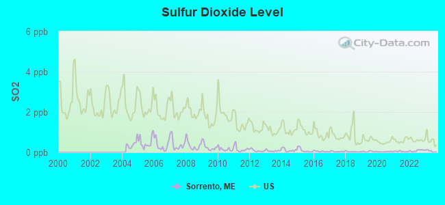
Sulfur Dioxide (SO2) [ppb] level in 2023 was 0.0636. This is significantly better than average. Closest monitor was 8.3 miles away from the city center.
| City: | 0.0636 |
| U.S.: | 1.5147 |
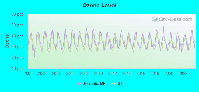
Ozone [ppb] level in 2023 was 36.9. This is about average. Closest monitor was 8.3 miles away from the city center.
| City: | 36.9 |
| U.S.: | 33.3 |
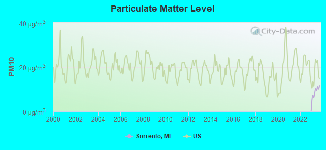
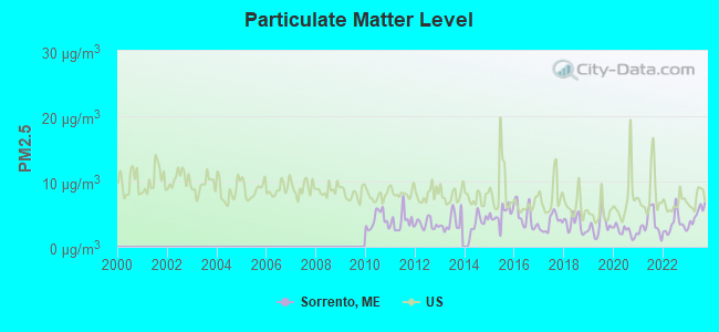
Particulate Matter (PM2.5) [µg/m3] level in 2023 was 4.90. This is significantly better than average. Closest monitor was 8.3 miles away from the city center.
| City: | 4.90 |
| U.S.: | 8.11 |
Earthquake activity:
Sorrento-area historical earthquake activity is significantly above Maine state average. It is 81% smaller than the overall U.S. average.On 10/16/2012 at 23:12:25, a magnitude 4.7 (4.7 ML, Depth: 10.0 mi, Class: Light, Intensity: IV - V) earthquake occurred 137.4 miles away from Sorrento center
On 4/20/2002 at 10:50:47, a magnitude 5.3 (5.3 ML, Depth: 3.0 mi, Class: Moderate, Intensity: VI - VII) earthquake occurred 272.1 miles away from Sorrento center
On 4/20/2002 at 10:50:47, a magnitude 5.2 (5.2 MB, 4.2 MS, 5.2 MW, 5.0 MW) earthquake occurred 273.1 miles away from Sorrento center
On 1/19/1982 at 00:14:42, a magnitude 4.7 (4.5 MB, 4.7 MD, 4.5 LG) earthquake occurred 183.2 miles away from Sorrento center
On 10/7/1983 at 10:18:46, a magnitude 5.3 (5.1 MB, 5.3 LG, 5.1 ML) earthquake occurred 307.5 miles away from Sorrento center
On 10/3/2006 at 00:07:38, a magnitude 3.7 (3.7 MD, Depth: 6.2 mi, Class: Light, Intensity: II - III) earthquake occurred 8.2 miles away from the city center
Magnitude types: regional Lg-wave magnitude (LG), body-wave magnitude (MB), duration magnitude (MD), local magnitude (ML), surface-wave magnitude (MS), moment magnitude (MW)
Natural disasters:
The number of natural disasters in Hancock County (18) is near the US average (15).Major Disasters (Presidential) Declared: 11
Emergencies Declared: 6
Causes of natural disasters: Floods: 9, Storms: 8, Snows: 5, Blizzard: 1, Heavy Rain: 1, Hurricane: 1, Ice Storm: 1, Landslide: 1, Snowfall: 1, Wind: 1, Winter Storm: 1, Other: 2 (Note: some incidents may be assigned to more than one category).

Hospitals and medical centers near Sorrento:
- SONOGEE ESTATES (Nursing Home, about 7 miles away; BAR HARBOR, ME)
- SONOGEE REHABILITATION AND LIVING CENTER (Nursing Home, about 7 miles away; BAR HARBOR, ME)
- MOUNT DESERT ISLAND HOSPITAL Critical Access Hospitals (about 7 miles away; BAR HARBOR, ME)
- BIRCHWOOD LIVING CENTER (Hospital, about 13 miles away; ELLSWORTH, ME)
- COLLIER'S REHAB AND NURSING CTR (Nursing Home, about 13 miles away; ELLSWORTH, ME)
- COURTLAND REHAB AND LIVING CENTER (Nursing Home, about 13 miles away; ELLSWORTH, ME)
Colleges/universities with over 2000 students nearest to Sorrento:
- University of Maine (about 38 miles; Orono, ME; Full-time enrollment: 8,931)
- Husson University (about 39 miles; Bangor, ME; FT enrollment: 2,421)
- University of Maine at Augusta (about 81 miles; Augusta, ME; FT enrollment: 3,204)
- University of Maine at Farmington (about 98 miles; Farmington, ME; FT enrollment: 2,036)
- Southern Maine Community College (about 117 miles; South Portland, ME; FT enrollment: 4,666)
- University of Southern Maine (about 119 miles; Portland, ME; FT enrollment: 6,647)
- Saint Joseph's College of Maine (about 123 miles; Standish, ME; FT enrollment: 2,010)
Points of interest:
Notable locations in Sorrento: West Coast Boat Yard (A), Sorrento Fire Department (B). Display/hide their locations on the map
Church in Sorrento: Sorrento Community Church (A). Display/hide its location on the map
Cemetery: Bragdon Cemetery (1). Display/hide its location on the map
Birthplace of: John Howland Rowe - Archaeologist.
| This town: | 1.9 people |
| Maine: | 2.3 people |
| This town: | 54.6% |
| Whole state: | 62.9% |
| This town: | 11.3% |
| Whole state: | 9.4% |
No gay or lesbian households reported
| This town: | 5.7% |
| Whole state: | 10.9% |
| This town: | 3.9% |
| Whole state: | 4.1% |
For population 15 years and over in Sorrento:
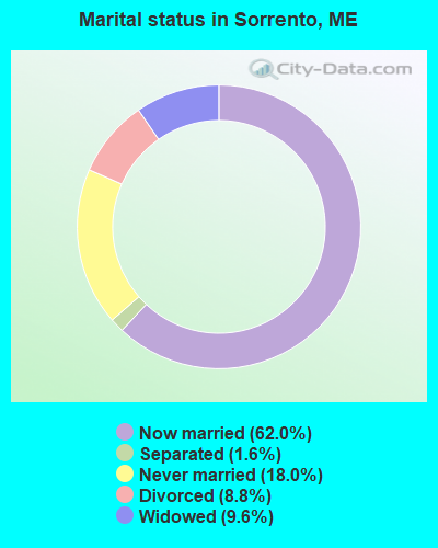
- Never married: 18.0%
- Now married: 62.0%
- Separated: 1.6%
- Widowed: 9.6%
- Divorced: 8.8%
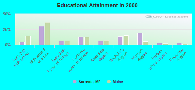
For population 25 years and over in Sorrento:
- High school or higher: 95.2%
- Bachelor's degree or higher: 39.3%
- Graduate or professional degree: 25.8%
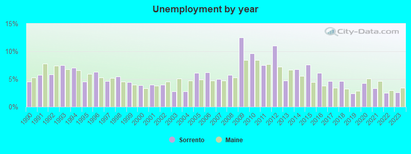
- Unemployed: 5.7%
- Mean travel time to work (commute): 22.6 minutes
| Here: | 11.3 |
| Maine average: | 11.2 |


Graphs represent county-level data. Detailed 2008 Election Results
Religion statistics for Sorrento, ME (based on Hancock County data)


| Religion | Adherents | Congregations |
|---|---|---|
| Mainline Protestant | 4,691 | 58 |
| Catholic | 2,523 | 9 |
| Evangelical Protestant | 1,288 | 23 |
| Other | 820 | 11 |
| None | 45,096 | - |
Food Environment Statistics:
| This county: | 6.01 / 10,000 pop. |
| Maine: | 2.80 / 10,000 pop. |
| Hancock County: | 1.69 / 10,000 pop. |
| State: | 2.20 / 10,000 pop. |
| Hancock County: | 4.89 / 10,000 pop. |
| State: | 5.75 / 10,000 pop. |
| Hancock County: | 21.61 / 10,000 pop. |
| Maine: | 11.02 / 10,000 pop. |
| Hancock County: | 7.4% |
| Maine: | 8.2% |
| Hancock County: | 25.4% |
| Maine: | 25.0% |
Strongest AM radio stations in Sorrento:
- WDEA (1370 AM; 5 kW; ELLSWORTH, ME; Owner: CUMULUS LICENSING CORP.)
- WZON (620 AM; 5 kW; BANGOR, ME; Owner: THE ZONE CORPORATION)
- WABI (910 AM; 5 kW; BANGOR, ME; Owner: CLEAR CHANNEL BROADCASTING LICENSES, INC.)
- WRKO (680 AM; 50 kW; BOSTON, MA; Owner: ENTERCOM BOSTON LICENSE, LLC)
- WSKW (1160 AM; 10 kW; SKOWHEGAN, ME; Owner: MOUNTAIN WIRELESS, INCORPORATED)
- WEEI (850 AM; 50 kW; BOSTON, MA; Owner: ENTERCOM BOSTON LICENSE, LLC)
- WBZ (1030 AM; 50 kW; BOSTON, MA; Owner: INFINITY BROADCASTING OPERATIONS, INC.)
- WCRN (830 AM; 50 kW; WORCESTER, MA; Owner: CARTER BROADCASTING CORPORATION)
- WNNZ (640 AM; 50 kW; WESTFIELD, MA; Owner: CLEAR CHANNEL BROADCASTING LICENSES, INC.)
- WTME (780 AM; 10 kW; RUMFORD, ME; Owner: MOUNTAIN VALLEY BROADCASTING, INC.)
- WKOX (1200 AM; 50 kW; FRAMINGHAM, MA; Owner: CAPSTAR TX LIMITED PARTNERSHIP)
- WALE (990 AM; 50 kW; GREENVILLE, RI; Owner: NORTH AMERICAN BROADCASTING CO., INC.)
- WWZN (1510 AM; 50 kW; BOSTON, MA; Owner: ROSE CITY RADIO CORPORATION)
Strongest FM radio stations in Sorrento:
- WNSX (97.7 FM; WINTER HARBOR, ME; Owner: CLEAR CHANNEL BROADCASTING LICENSES, INC.)
- WBQI (107.7 FM; BAR HARBOR, ME; Owner: MARINER BROADCASTING, L.P.)
- WLKE (99.1 FM; BAR HARBOR, ME; Owner: CLEAR CHANNEL BROADCASTING LICENSES, INC.)
- WERU-FM (89.9 FM; BLUE HILL, ME; Owner: SALT POND COMMUNITY B/C COMPANY)
- WWMJ (95.7 FM; ELLSWORTH, ME; Owner: CUMULUS LICENSING CORP.)
- WMEH (90.9 FM; BANGOR, ME; Owner: MAINE PUBLIC BROADCASTING CORPORATION)
- WHCF (88.5 FM; BANGOR, ME; Owner: BANGOR BAPTIST CHURCH)
- WEZQ (92.9 FM; BANGOR, ME; Owner: CUMULUS LICENSING CORP.)
- WBFB (104.7 FM; BELFAST, ME; Owner: CLEAR CHANNEL BROADCASTING LICENSES, INC.)
- WKIT-FM (100.3 FM; BREWER, ME; Owner: THE ZONE CORPORATION)
- WFZX (101.7 FM; SEARSPORT, ME; Owner: CLEAR CHANNEL BROADCASTING LICENSES, INC.)
- WVOM (103.9 FM; HOWLAND, ME; Owner: CLEAR CHANNEL BROADCASTING LICENSES, INC.)
- WWBX (97.1 FM; BANGOR, ME; Owner: CLEAR CHANNEL BROADCASTING LICENSES, INC.)
TV broadcast stations around Sorrento:
- WMEB-TV (Channel 12; ORONO, ME; Owner: MAINE PUBLIC BROADCASTING CORPORATION)
Sorrento fatal accident list:
FCC Registered Broadcast Land Mobile Towers:
1- Lat: 44.483694 Lon: -68.168889, Call Sign: WQBV929,
Assigned Frequencies: 159.225 MHz, 156.015 MHz, 153.852 MHz, Grant Date: 09/30/2014, Expiration Date: 12/27/2024, Certifier: Joey C Clark, Registrant: Browns Communications, 162 Bangor Road, Elssworth, ME 04605, Phone: (207) 667-2254, Fax: (207) 667-6335, Email:
FCC Registered Amateur Radio Licenses:
11 (See the full list of FCC Registered Amateur Radio Licenses in Sorrento)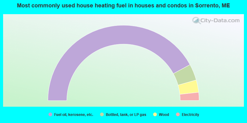
- 84.2%Fuel oil, kerosene, etc.
- 7.0%Bottled, tank, or LP gas
- 5.3%Wood
- 3.5%Electricity
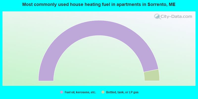
- 93.8%Fuel oil, kerosene, etc.
- 6.2%Bottled, tank, or LP gas
Sorrento compared to Maine state average:
- Unemployed percentage below state average.
- Black race population percentage significantly below state average.
- Hispanic race population percentage significantly below state average.
- Median age significantly above state average.
- Foreign-born population percentage significantly below state average.
- Renting percentage significantly below state average.
- Length of stay since moving in significantly above state average.
- Number of rooms per house significantly below state average.
- House age significantly below state average.
- Number of college students below state average.

|
Total of 3 patent applications in 2008-2024.