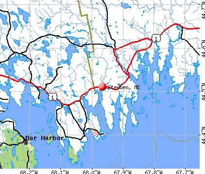
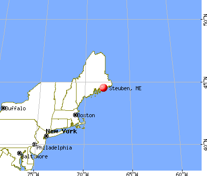
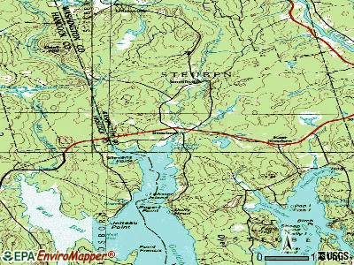
Steuben, Maine

Steuben: Sacred Time
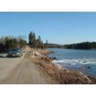
Steuben: Pinkham Bay Bridge Road
Steuben: Steuben Flowerbox

Steuben: Deer on Dyer's Bay Road
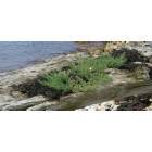
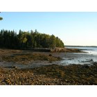
Steuben: Pebble Beach

Steuben: Sunset over the Bay, Steuben Maine

Steuben: Joy Bay Cove at sunset in Steuben, Maine
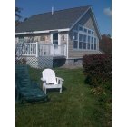
Steuben: Quaint Cottage on Scenic Pigeon Hill Bay

Steuben: sunset in Steuben
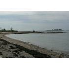
Steuben: Canes Cove, Steuben Maine

Steuben: Steuben Townhouse
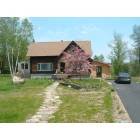
Steuben: Log Cabin
- add
your
Submit your own pictures of this town and show them to the world
- OSM Map
- General Map
- Google Map
- MSN Map
Population change since 2000: +0.4%
 |
| Males: 574 | |
| Females: 557 |
| Median resident age: | 42.4 years |
| Maine median age: | 43.0 years |
Zip codes: 04680.
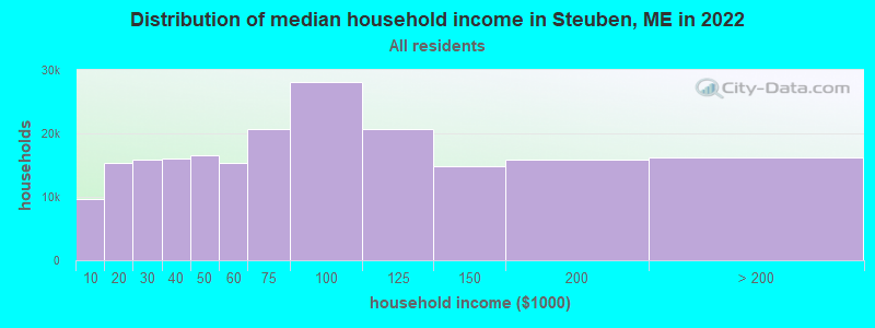
| Steuben: | $51,302 |
| ME: | $69,543 |
Estimated per capita income in 2022: $27,451 (it was $12,162 in 2000)
Steuben town income, earnings, and wages data
Estimated median house or condo value in 2022: $165,831 (it was $68,300 in 2000)
| Steuben: | $165,831 |
| ME: | $290,600 |
Mean prices in 2022: all housing units: $208,896; detached houses: $229,377; townhouses or other attached units: $190,242; in 2-unit structures: $139,050; in 3-to-4-unit structures: $456,045; in 5-or-more-unit structures: $413,457; mobile homes: $94,515; occupied boats, rvs, vans, etc.: $45,679
Detailed information about poverty and poor residents in Steuben, ME


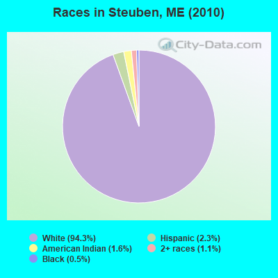
- 1,06794.3%White alone
- 262.3%Hispanic
- 181.6%American Indian alone
- 131.1%Two or more races
- 60.5%Black alone
- 10.09%Asian alone
Races in Steuben detailed stats: ancestries, foreign born residents, place of birth
According to our research of Maine and other state lists, there were 4 registered sex offenders living in Steuben, Maine as of April 27, 2024.
The ratio of all residents to sex offenders in Steuben is 283 to 1.
 Recent articles from our blog. Our writers, many of them Ph.D. graduates or candidates, create easy-to-read articles on a wide variety of topics.

 | Hows maine (44 replies) |
| Looking for Suggestions Please (10 replies) |
| Summer home coastal communities (7 replies) |
| Services in Washington County (31 replies) |
| Less Touristy coastal towns? (32 replies) |
| Not making progress on my plan to move to Maine; need tips (47 replies) |
Latest news from Steuben, ME collected exclusively by city-data.com from local newspapers, TV, and radio stations
Ancestries: English (33.8%), Irish (20.2%), French (10.0%), United States (9.9%), German (5.8%), Italian (3.7%).
Current Local Time: EST time zone
Incorporated on 02/27/1795
Elevation: 50 feet
Land area: 43.0 square miles.
Population density: 26 people per square mile (very low).
19 residents are foreign born
| This town: | 1.7% |
| Maine: | 2.9% |
| Steuben town: | 1.2% ($821) |
| Maine: | 1.5% ($1,417) |
Nearest city with pop. 50,000+: Portland, ME  (129.6 miles , pop. 64,249).
Nearest city with pop. 200,000+: Boston, MA (218.8 miles , pop. 589,141).
Nearest city with pop. 1,000,000+: Bronx, NY (393.7 miles , pop. 1,332,650).
Nearest cities:
), ), Latitude: 44.51 N, Longitude: 67.94 W
Area code commonly used in this area: 207

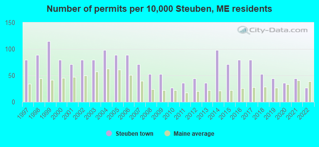
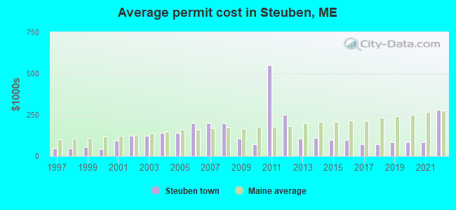
Single-family new house construction building permits:
- 2022: 3 buildings, average cost: $279,200
- 2021: 5 buildings, average cost: $83,300
- 2020: 4 buildings, average cost: $83,300
- 2019: 5 buildings, average cost: $83,300
- 2018: 6 buildings, average cost: $72,700
- 2017: 9 buildings, average cost: $71,500
- 2016: 9 buildings, average cost: $98,400
- 2015: 8 buildings, average cost: $98,400
- 2014: 11 buildings, average cost: $108,900
- 2013: 4 buildings, average cost: $107,500
- 2012: 5 buildings, average cost: $250,400
- 2011: 4 buildings, average cost: $550,000
- 2010: 3 buildings, average cost: $73,300
- 2009: 6 buildings, average cost: $105,000
- 2008: 6 buildings, average cost: $198,500
- 2007: 8 buildings, average cost: $198,500
- 2006: 10 buildings, average cost: $198,500
- 2005: 10 buildings, average cost: $138,800
- 2004: 11 buildings, average cost: $138,800
- 2003: 9 buildings, average cost: $122,500
- 2002: 9 buildings, average cost: $121,700
- 2001: 8 buildings, average cost: $93,400
- 2000: 9 buildings, average cost: $44,400
- 1999: 13 buildings, average cost: $53,800
- 1998: 10 buildings, average cost: $44,500
- 1997: 9 buildings, average cost: $44,500
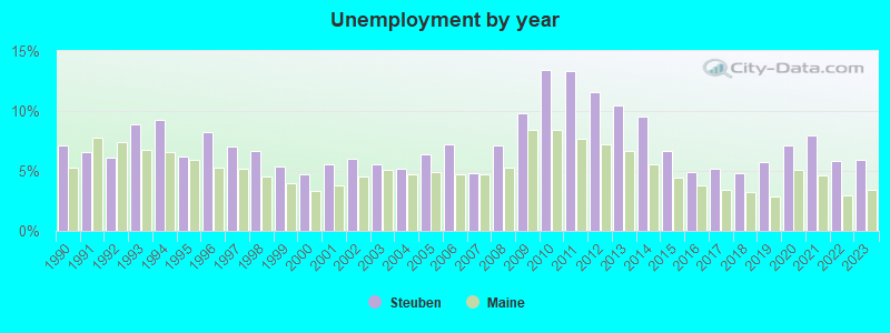
| Here: | 5.9% |
| Maine: | 3.4% |
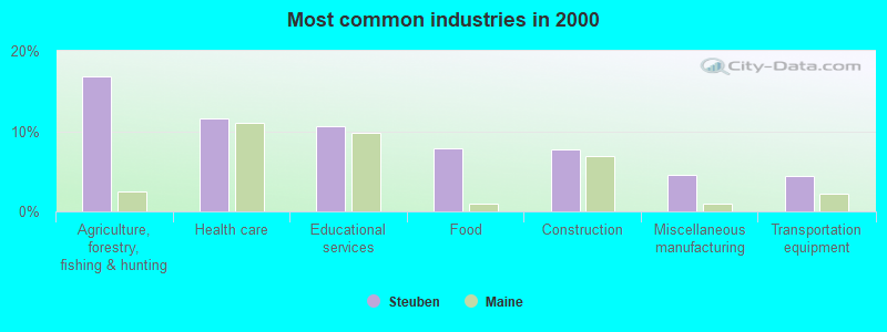
- Agriculture, forestry, fishing & hunting (16.8%)
- Health care (11.6%)
- Educational services (10.6%)
- Food (7.9%)
- Construction (7.7%)
- Miscellaneous manufacturing (4.6%)
- Transportation equipment (4.4%)
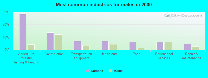
- Agriculture, forestry, fishing & hunting (28.4%)
- Construction (13.6%)
- Transportation equipment (6.8%)
- Health care (6.8%)
- Food (6.0%)
- Educational services (6.0%)
- Repair & maintenance (4.8%)
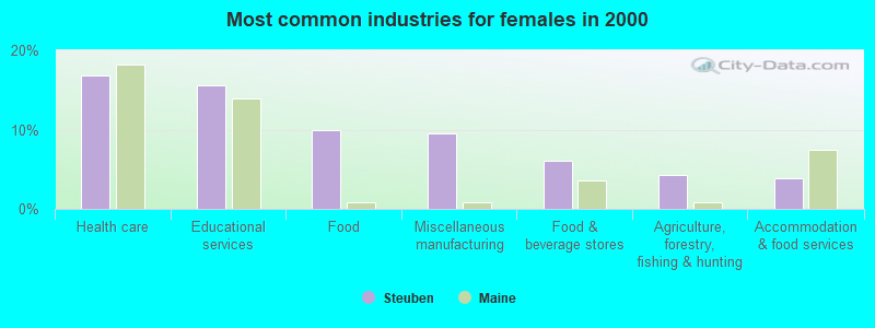
- Health care (16.9%)
- Educational services (15.6%)
- Food (10.0%)
- Miscellaneous manufacturing (9.5%)
- Food & beverage stores (6.1%)
- Agriculture, forestry, fishing & hunting (4.3%)
- Accommodation & food services (3.9%)

- Fishing, hunting, and forestry occupations (14.3%)
- Other production occupations, including supervisors (7.9%)
- Assemblers and fabricators (5.0%)
- Vehicle and mobile equipment mechanics, installers, and repairers (5.0%)
- Carpenters (4.8%)
- Preschool, kindergarten, elementary, and middle school teachers (4.6%)
- Registered nurses (4.4%)
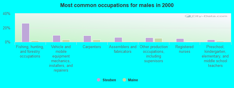
- Fishing, hunting, and forestry occupations (26.4%)
- Vehicle and mobile equipment mechanics, installers, and repairers (9.6%)
- Carpenters (9.2%)
- Assemblers and fabricators (6.8%)
- Other production occupations, including supervisors (6.0%)
- Registered nurses (4.8%)
- Preschool, kindergarten, elementary, and middle school teachers (3.2%)
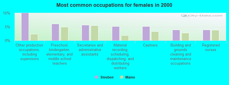
- Other production occupations, including supervisors (10.0%)
- Preschool, kindergarten, elementary, and middle school teachers (6.1%)
- Secretaries and administrative assistants (5.6%)
- Material recording, scheduling, dispatching, and distributing workers (5.2%)
- Cashiers (5.2%)
- Building and grounds cleaning and maintenance occupations (3.9%)
- Registered nurses (3.9%)
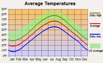
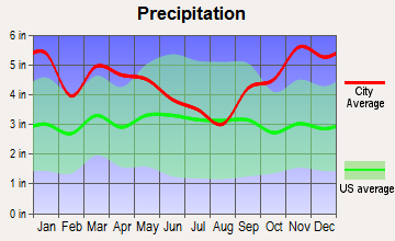
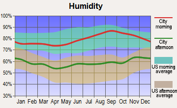
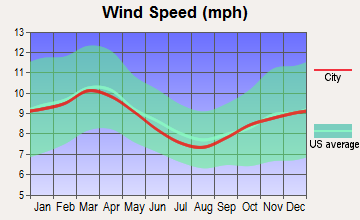
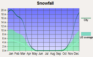
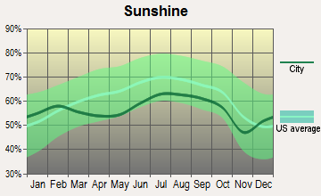
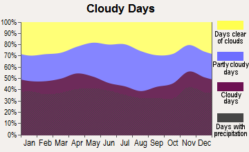
Average climate in Steuben, Maine
Based on data reported by over 4,000 weather stations
(lower is better)
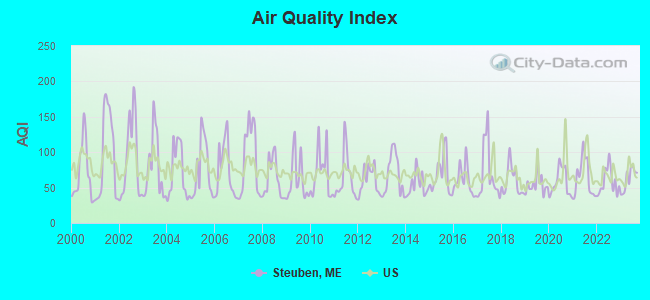
Air Quality Index (AQI) level in 2023 was 61.9. This is about average.
| City: | 61.9 |
| U.S.: | 72.6 |
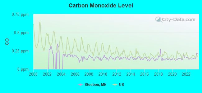
Carbon Monoxide (CO) [ppm] level in 2023 was 0.172. This is significantly better than average. Closest monitor was 17.8 miles away from the city center.
| City: | 0.172 |
| U.S.: | 0.251 |
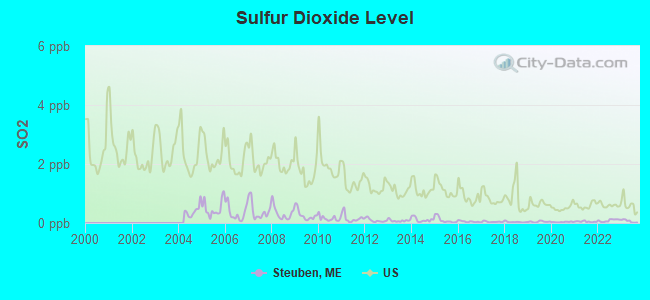
Sulfur Dioxide (SO2) [ppb] level in 2023 was 0.0636. This is significantly better than average. Closest monitor was 18.3 miles away from the city center.
| City: | 0.0636 |
| U.S.: | 1.5147 |
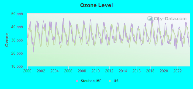
Ozone [ppb] level in 2023 was 35.3. This is about average. Closest monitor was 13.2 miles away from the city center.
| City: | 35.3 |
| U.S.: | 33.3 |
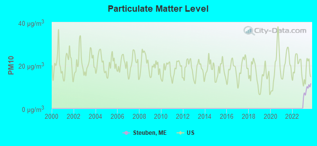
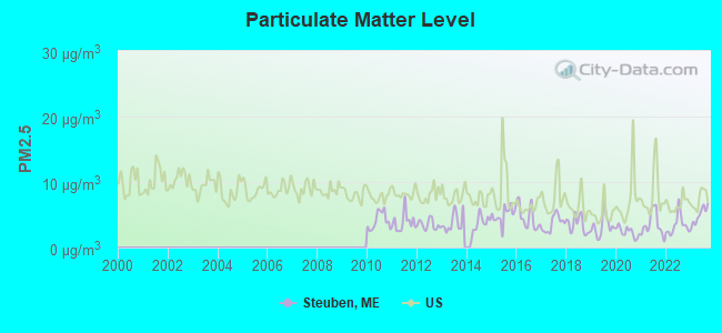
Particulate Matter (PM2.5) [µg/m3] level in 2023 was 4.90. This is significantly better than average. Closest monitor was 18.3 miles away from the city center.
| City: | 4.90 |
| U.S.: | 8.11 |
Earthquake activity:
Steuben-area historical earthquake activity is significantly above Maine state average. It is 82% smaller than the overall U.S. average.On 10/16/2012 at 23:12:25, a magnitude 4.7 (4.7 ML, Depth: 10.0 mi, Class: Light, Intensity: IV - V) earthquake occurred 149.0 miles away from Steuben center
On 4/20/2002 at 10:50:47, a magnitude 5.3 (5.3 ML, Depth: 3.0 mi, Class: Moderate, Intensity: VI - VII) earthquake occurred 284.0 miles away from Steuben center
On 4/20/2002 at 10:50:47, a magnitude 5.2 (5.2 MB, 4.2 MS, 5.2 MW, 5.0 MW) earthquake occurred 285.1 miles away from the city center
On 1/19/1982 at 00:14:42, a magnitude 4.7 (4.5 MB, 4.7 MD, 4.5 LG) earthquake occurred 195.0 miles away from the city center
On 10/7/1983 at 10:18:46, a magnitude 5.3 (5.1 MB, 5.3 LG, 5.1 ML) earthquake occurred 319.6 miles away from the city center
On 10/3/2006 at 00:07:38, a magnitude 3.7 (3.7 MD, Depth: 6.2 mi, Class: Light, Intensity: II - III) earthquake occurred 14.1 miles away from Steuben center
Magnitude types: regional Lg-wave magnitude (LG), body-wave magnitude (MB), duration magnitude (MD), local magnitude (ML), surface-wave magnitude (MS), moment magnitude (MW)
Natural disasters:
The number of natural disasters in Washington County (20) is greater than the US average (15).Major Disasters (Presidential) Declared: 14
Emergencies Declared: 6
Causes of natural disasters: Floods: 11, Storms: 10, Snows: 5, Winds: 2, Winter Storms: 2, Blizzard: 1, Heavy Rain: 1, Hurricane: 1, Ice Storm: 1, Landslide: 1, Snowfall: 1, Other: 2 (Note: some incidents may be assigned to more than one category).
Colleges/universities with over 2000 students nearest to Steuben:
- University of Maine (about 46 miles; Orono, ME; Full-time enrollment: 8,931)
- Husson University (about 48 miles; Bangor, ME; FT enrollment: 2,421)
- University of Maine at Augusta (about 93 miles; Augusta, ME; FT enrollment: 3,204)
- University of Maine at Farmington (about 110 miles; Farmington, ME; FT enrollment: 2,036)
- Southern Maine Community College (about 129 miles; South Portland, ME; FT enrollment: 4,666)
- University of Southern Maine (about 130 miles; Portland, ME; FT enrollment: 6,647)
- Saint Joseph's College of Maine (about 135 miles; Standish, ME; FT enrollment: 2,010)
Public elementary/middle school in Steuben:
- ELLA LEWIS SCHOOL (Students: 103, Location: 15 OLD VILLAGE ROAD, Grades: PK-8)
Points of interest:
Notable locations in Steuben: Eagle Hill Wildlife Research Station (A), Carrying Place (B), Mainayr Campground (C), Steuben Volunteer Fire Department (D). Display/hide their locations on the map
Lakes and reservoirs: Mill Pond (A), Big Pond (B), Chair Pond (C), Round Pond (D), East Steuben Pond (E). Display/hide their locations on the map
Streams, rivers, and creeks: Tunk Stream (A). Display/hide its location on the map
Park in Steuben: Petit Manan National Wildlife Refuge (1). Display/hide its location on the map
Drinking water stations with addresses in Steuben and their reported violations in the past:
EAGLE HILL INSTITUTE-DINING (Population served: 203, Groundwater):Past health violations:MAINAYR CAMPGROUND (Population served: 75, Groundwater):Past monitoring violations:
- MCL, Monthly (TCR) - In OCT-2012, Contaminant: Coliform. Follow-up actions: St Public Notif requested (OCT-11-2012), St Formal NOV issued (OCT-11-2012), St Public Notif received (JAN-07-2013), St Compliance achieved (MAY-29-2013)
- MCL, Monthly (TCR) - In OCT-2011, Contaminant: Coliform. Follow-up actions: St Formal NOV issued (NOV-01-2011), St Public Notif requested (NOV-01-2011), St Public Notif received (MAR-26-2012), St Compliance achieved (APR-05-2012)
- MCL, Monthly (TCR) - In AUG-2011, Contaminant: Coliform. Follow-up actions: St Public Notif requested (SEP-22-2011), St Formal NOV issued (SEP-22-2011), St Public Notif received (OCT-11-2011), St Compliance achieved (NOV-09-2011)
- Monitoring, Repeat Major (TCR) - In AUG-2012, Contaminant: Coliform (TCR). Follow-up actions: St Public Notif requested (OCT-01-2012), St Formal NOV issued (OCT-01-2012), St Compliance achieved (MAY-29-2013), St Site Visit (enforcement) (JUN-19-2013), St Public Notif received (JUN-19-2013)
- 4 routine major monitoring violations
Past monitoring violations:EAGLE HILL INSTITUTE-DORM (Population served: 26, Groundwater):
- 11 routine major monitoring violations
- 5 regular monitoring violations
Past health violations:Past monitoring violations:
- MCL, Monthly (TCR) - In MAY-2012, Contaminant: Coliform. Follow-up actions: St Public Notif requested (JUN-11-2012), St Formal NOV issued (JUN-11-2012), St Compliance achieved (JUN-26-2012), St Public Notif received (JUL-11-2012)
- 2 routine major monitoring violations
| This town: | 2.4 people |
| Maine: | 2.3 people |
| This town: | 64.6% |
| Whole state: | 62.9% |
| This town: | 13.3% |
| Whole state: | 9.4% |
Likely homosexual households (counted as self-reported same-sex unmarried-partner households)
- Lesbian couples: 0.8% of all households
- Gay men: 0.4% of all households
| This town: | 19.5% |
| Whole state: | 10.9% |
| This town: | 5.8% |
| Whole state: | 4.1% |
For population 15 years and over in Steuben:
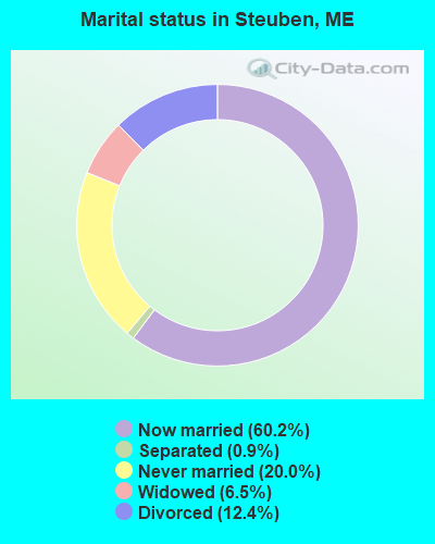
- Never married: 20.0%
- Now married: 60.2%
- Separated: 0.9%
- Widowed: 6.5%
- Divorced: 12.4%
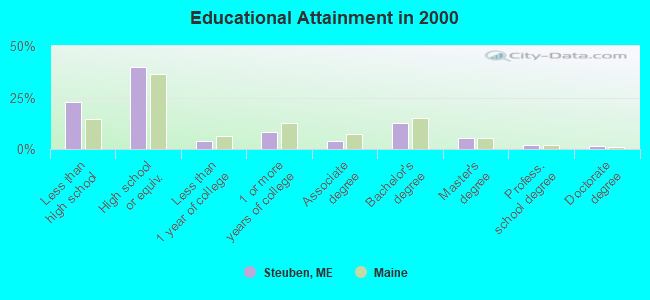
For population 25 years and over in Steuben:
- High school or higher: 77.2%
- Bachelor's degree or higher: 21.0%
- Graduate or professional degree: 8.6%
- Unemployed: 4.0%
- Mean travel time to work (commute): 25.5 minutes
| Here: | 11.8 |
| Maine average: | 11.2 |
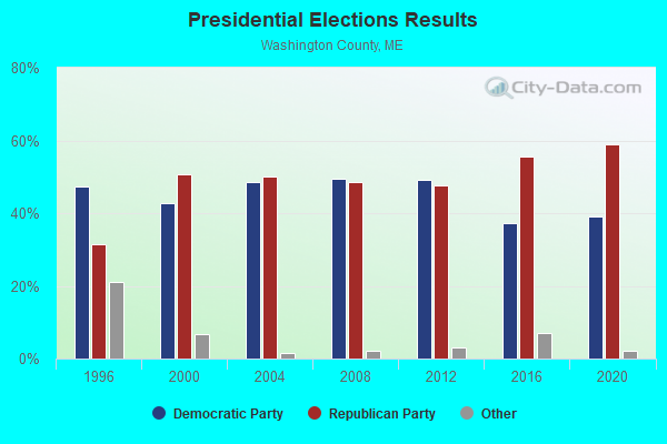

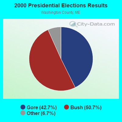


Graphs represent county-level data. Detailed 2008 Election Results
Religion statistics for Steuben, ME (based on Washington County data)
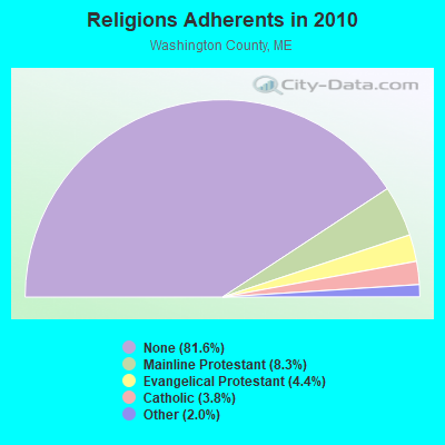
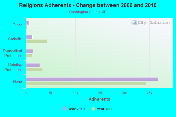
| Religion | Adherents | Congregations |
|---|---|---|
| Mainline Protestant | 2,731 | 37 |
| Evangelical Protestant | 1,442 | 31 |
| Catholic | 1,238 | 10 |
| Other | 648 | 13 |
| None | 26,797 | - |
Food Environment Statistics:
| Washington County: | 4.89 / 10,000 pop. |
| Maine: | 2.80 / 10,000 pop. |
| Washington County: | 1.22 / 10,000 pop. |
| Maine: | 2.20 / 10,000 pop. |
| This county: | 9.78 / 10,000 pop. |
| Maine: | 5.75 / 10,000 pop. |
| This county: | 11.31 / 10,000 pop. |
| Maine: | 11.02 / 10,000 pop. |
| This county: | 9.4% |
| Maine: | 8.2% |
| Washington County: | 28.3% |
| Maine: | 25.0% |
Strongest AM radio stations in Steuben:
- WDEA (1370 AM; 5 kW; ELLSWORTH, ME; Owner: CUMULUS LICENSING CORP.)
- WZON (620 AM; 5 kW; BANGOR, ME; Owner: THE ZONE CORPORATION)
- WABI (910 AM; 5 kW; BANGOR, ME; Owner: CLEAR CHANNEL BROADCASTING LICENSES, INC.)
- WRKO (680 AM; 50 kW; BOSTON, MA; Owner: ENTERCOM BOSTON LICENSE, LLC)
- WSKW (1160 AM; 10 kW; SKOWHEGAN, ME; Owner: MOUNTAIN WIRELESS, INCORPORATED)
- WEEI (850 AM; 50 kW; BOSTON, MA; Owner: ENTERCOM BOSTON LICENSE, LLC)
- WBZ (1030 AM; 50 kW; BOSTON, MA; Owner: INFINITY BROADCASTING OPERATIONS, INC.)
- WCRN (830 AM; 50 kW; WORCESTER, MA; Owner: CARTER BROADCASTING CORPORATION)
- WNNZ (640 AM; 50 kW; WESTFIELD, MA; Owner: CLEAR CHANNEL BROADCASTING LICENSES, INC.)
- WKOX (1200 AM; 50 kW; FRAMINGHAM, MA; Owner: CAPSTAR TX LIMITED PARTNERSHIP)
- WALE (990 AM; 50 kW; GREENVILLE, RI; Owner: NORTH AMERICAN BROADCASTING CO., INC.)
- WTME (780 AM; 10 kW; RUMFORD, ME; Owner: MOUNTAIN VALLEY BROADCASTING, INC.)
- WWZN (1510 AM; 50 kW; BOSTON, MA; Owner: ROSE CITY RADIO CORPORATION)
Strongest FM radio stations in Steuben:
- WNSX (97.7 FM; WINTER HARBOR, ME; Owner: CLEAR CHANNEL BROADCASTING LICENSES, INC.)
- WBQI (107.7 FM; BAR HARBOR, ME; Owner: MARINER BROADCASTING, L.P.)
- WLKE (99.1 FM; BAR HARBOR, ME; Owner: CLEAR CHANNEL BROADCASTING LICENSES, INC.)
- WHCF (88.5 FM; BANGOR, ME; Owner: BANGOR BAPTIST CHURCH)
- WWMJ (95.7 FM; ELLSWORTH, ME; Owner: CUMULUS LICENSING CORP.)
- WERU-FM (89.9 FM; BLUE HILL, ME; Owner: SALT POND COMMUNITY B/C COMPANY)
- WMEH (90.9 FM; BANGOR, ME; Owner: MAINE PUBLIC BROADCASTING CORPORATION)
- WEZQ (92.9 FM; BANGOR, ME; Owner: CUMULUS LICENSING CORP.)
- WKIT-FM (100.3 FM; BREWER, ME; Owner: THE ZONE CORPORATION)
- Steuben, Maine
- Fatal accident count12
- Vehicles involved in fatal accidents19
- Fatal accidents involving drunk persons:2
- Fatalities13
- Persons involved in fatal accidents30
- Pedestrians involved in fatal accidents0
- Maine average
- Fatal accident count1850
- Vehicles involved in fatal accidents2698
- Fatal accidents involving drunk persons641
- Fatalities2020
- Persons involved in fatal accidents4247
- Pedestrians involved in fatal accidents199
- National Bridge Inventory (NBI) Statistics
- 6Number of bridges
- 30ft / 8.7mTotal length
- 8,507Total average daily traffic
- 422Total average daily truck traffic
- 12,130Total future (year 2036) average daily traffic
FCC Registered Antenna Towers:
5- Robert Parsloe, C&c Lane (Lat: 44.441389 Lon: -67.941389), Type: 59.7, Structure height: 23029 m, Overall height: 57.9 m, Registrant: Rising Tide Towers LLC, Rparsloe@wireless-Partnersllc.Com, , Portl-and, Phone: (207) 808-5000
- Robert Parlsoe, C&c Lane (Lat: 44.441389 Lon: -67.941389), Type: 59.7, Structure height: 23029 m, Overall height: 57.9 m, Registrant: Rising Tide Towers LLC, Rparsloe@wireless-Partnersllc.Com, , Portl-and, Phone: (207) 808-5000
- Robert Parsloe, C&c Lane (Lat: 44.441389 Lon: -67.941389), Type: 59.7, Structure height: 23029 m, Overall height: 57.9 m, Registrant: Rising Tide Towers LLC, Rparsloe@wireless-Partnersllc.Com, , Portl-and, Phone: (207) 808-5000
- Robert Parsloe, C&c Lane (Lat: 44.441389 Lon: -67.941389), Type: 59.7, Structure height: 23029 m, Overall height: 57.9 m, Registrant: Rising Tide Towers LLC, Rparsloe@wireless-Partnersllc.Com, , Portl-and, Phone: (207) 808-5000
- Edward G Roach, C&c Lane (Lat: 44.441389 Lon: -67.941389), Type: 59.7, Structure height: 23029 m, Overall height: 57.9 m, Registrant: Sba Towers Xi, LLC, Eroach@sbasite.Com, , Boca -Raton, Phone: (561) 995-7670
FCC Registered Amateur Radio Licenses:
10 (See the full list of FCC Registered Amateur Radio Licenses in Steuben)2003 - 2018 National Fire Incident Reporting System (NFIRS) incidents
- Fire incident types reported to NFIRS in Steuben, ME
- 7861.9%Structure Fires
- 2318.3%Outside Fires
- 1713.5%Mobile Property/Vehicle Fires
- 86.3%Other
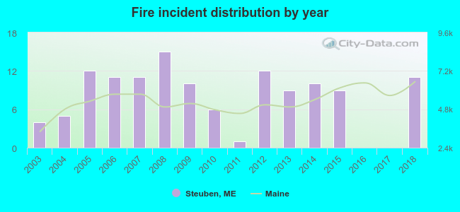 Based on the data from the years 2003 - 2018 the average number of fires per year is 8. The highest number of reported fires - 15 took place in 2008, and the least - 0 in 2016. The data has a growing trend.
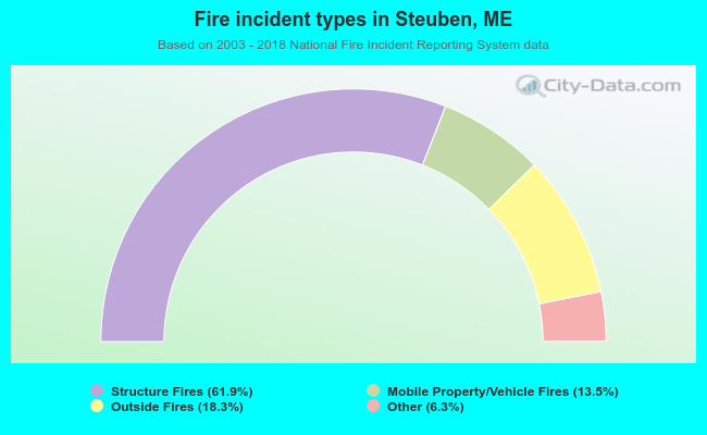 When looking into fire subcategories, the most incidents belonged to: Structure Fires (61.9%), and Outside Fires (18.3%).
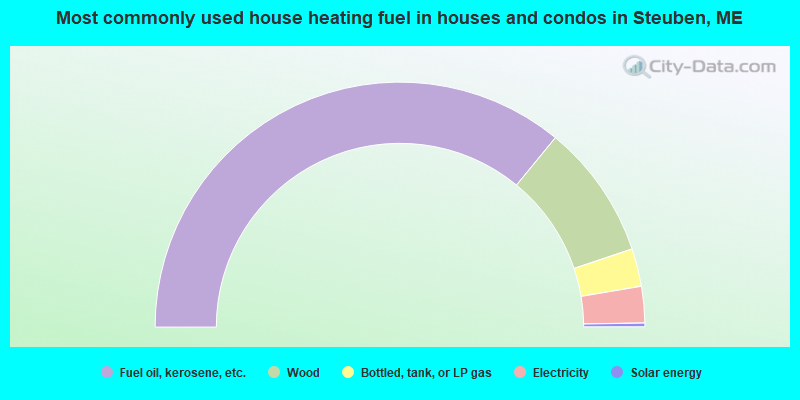
- 71.9%Fuel oil, kerosene, etc.
- 17.8%Wood
- 5.0%Bottled, tank, or LP gas
- 4.8%Electricity
- 0.5%Solar energy

- 78.7%Fuel oil, kerosene, etc.
- 11.5%Bottled, tank, or LP gas
- 6.6%Wood
- 3.3%Electricity
Steuben compared to Maine state average:
- Median house value below state average.
- Unemployed percentage significantly below state average.
- Black race population percentage significantly below state average.
- Foreign-born population percentage below state average.
- Renting percentage below state average.
- Length of stay since moving in significantly above state average.
- Number of rooms per house significantly below state average.
- House age significantly below state average.
- Number of college students below state average.

|
Total of 1 patent application in 2008-2024.