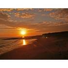
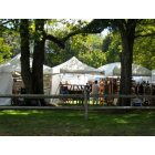
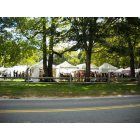
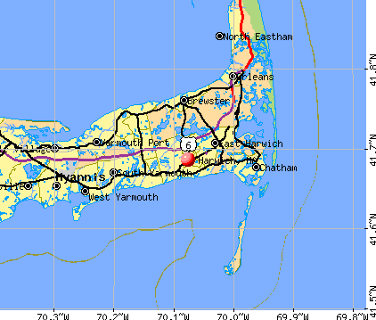
Harwich, Massachusetts
Submit your own pictures of this town and show them to the world
- OSM Map
- General Map
- Google Map
- MSN Map
Population change since 2000: -1.2%
 |
| Males: 5,688 | |
| Females: 6,555 |
| Median resident age: | 52.6 years |
| Massachusetts median age: | 39.2 years |
Zip codes: 02645.
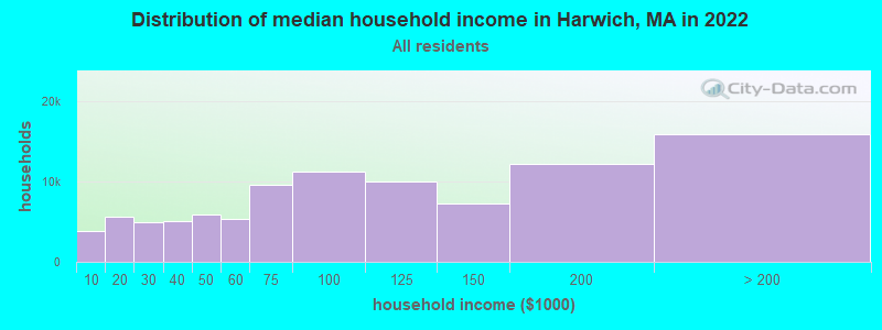
| Harwich: | $82,717 |
| MA: | $94,488 |
Estimated per capita income in 2022: $54,990 (it was $23,063 in 2000)
Harwich town income, earnings, and wages data
Estimated median house or condo value in 2022: $638,090 (it was $180,000 in 2000)
| Harwich: | $638,090 |
| MA: | $534,700 |
Mean prices in 2022: all housing units: $623,757; detached houses: $648,447; townhouses or other attached units: $490,502; in 2-unit structures: $577,155; in 3-to-4-unit structures: $445,551; in 5-or-more-unit structures: $351,307; mobile homes: $108,058
Detailed information about poverty and poor residents in Harwich, MA


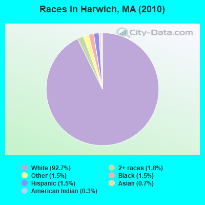
- 11,34792.7%White alone
- 2221.8%Two or more races
- 1881.5%Black alone
- 1891.5%Other race alone
- 1781.5%Hispanic
- 800.7%Asian alone
- 370.3%American Indian alone
- 20.02%Native Hawaiian and Other
Pacific Islander alone
Races in Harwich detailed stats: ancestries, foreign born residents, place of birth
According to our research of Massachusetts and other state lists, there were 6 registered sex offenders living in Harwich, Massachusetts as of April 28, 2024.
The ratio of all residents to sex offenders in Harwich is 2,041 to 1.
The ratio of registered sex offenders to all residents in this city is lower than the state average.
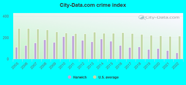
Type |
2009 |
2010 |
2011 |
2012 |
2013 |
2014 |
2015 |
2016 |
2017 |
2018 |
2019 |
2020 |
2021 |
2022 |
|---|---|---|---|---|---|---|---|---|---|---|---|---|---|---|
| Murders (per 100,000) | 0 (0.0) | 0 (0.0) | 0 (0.0) | 0 (0.0) | 0 (0.0) | 0 (0.0) | 0 (0.0) | 0 (0.0) | 0 (0.0) | 0 (0.0) | 0 (0.0) | 0 (0.0) | 0 (0.0) | 0 (0.0) |
| Rapes (per 100,000) | 1 (8.0) | 5 (40.8) | 4 (32.5) | 4 (32.4) | 2 (16.3) | 10 (81.8) | 4 (32.8) | 4 (33.0) | 1 (8.2) | 4 (33.0) | 2 (16.6) | 5 (41.4) | 3 (24.5) | 1 (7.2) |
| Robberies (per 100,000) | 3 (24.1) | 5 (40.8) | 3 (24.4) | 0 (0.0) | 1 (8.1) | 1 (8.2) | 1 (8.2) | 1 (8.3) | 0 (0.0) | 2 (16.5) | 1 (8.3) | 0 (0.0) | 0 (0.0) | 1 (7.2) |
| Assaults (per 100,000) | 16 (128.7) | 24 (196.0) | 35 (284.1) | 24 (194.4) | 21 (170.7) | 19 (155.4) | 35 (287.4) | 20 (165.1) | 22 (181.1) | 18 (148.4) | 19 (158.0) | 21 (174.0) | 16 (130.8) | 12 (86.4) |
| Burglaries (per 100,000) | 120 (964.9) | 148 (1,209) | 144 (1,169) | 119 (964.0) | 120 (975.7) | 91 (744.4) | 68 (558.4) | 49 (404.6) | 58 (477.4) | 34 (280.3) | 26 (216.2) | 18 (149.2) | 23 (188.0) | 22 (158.4) |
| Thefts (per 100,000) | 146 (1,174) | 118 (963.8) | 132 (1,072) | 126 (1,021) | 124 (1,008) | 112 (916.2) | 109 (895.1) | 97 (800.9) | 88 (724.3) | 92 (758.5) | 73 (606.9) | 54 (447.5) | 61 (498.6) | 73 (525.5) |
| Auto thefts (per 100,000) | 5 (40.2) | 5 (40.8) | 7 (56.8) | 4 (32.4) | 7 (56.9) | 2 (16.4) | 9 (73.9) | 7 (57.8) | 5 (41.2) | 3 (24.7) | 5 (41.6) | 4 (33.1) | 3 (24.5) | 2 (14.4) |
| Arson (per 100,000) | 1 (8.0) | 0 (0.0) | 5 (40.6) | 1 (8.1) | 0 (0.0) | 0 (0.0) | 1 (8.2) | 0 (0.0) | 0 (0.0) | 0 (0.0) | 1 (8.3) | 0 (0.0) | 1 (8.2) | 1 (7.2) |
| City-Data.com crime index | 157.1 | 210.6 | 219.4 | 175.7 | 162.8 | 189.1 | 167.0 | 126.9 | 108.5 | 112.9 | 90.1 | 98.9 | 80.8 | 58.5 |
The City-Data.com crime index weighs serious crimes and violent crimes more heavily. Higher means more crime, U.S. average is 246.1. It adjusts for the number of visitors and daily workers commuting into cities.
Crime rate in Harwich detailed stats: murders, rapes, robberies, assaults, burglaries, thefts, arson
Full-time law enforcement employees in 2021, including police officers: 40 (33 officers - 31 male; 2 female).
| Officers per 1,000 residents here: | 2.70 |
| Massachusetts average: | 2.53 |
 Recent articles from our blog. Our writers, many of them Ph.D. graduates or candidates, create easy-to-read articles on a wide variety of topics.

 | 2024 Real Estate Observations (799 replies) |
| 2023 Real Estate Observations (5278 replies) |
| Where to stay on cape cod (and is it worth going in April)? (71 replies) |
| MA 2022 Question 1 (258 replies) |
| Big MA Ancestry Data Thread by Town (31 replies) |
| 2021 Real Estate Observations (1729 replies) |
Latest news from Harwich, MA collected exclusively by city-data.com from local newspapers, TV, and radio stations
Harwich, MA City Guides:
Ancestries: Irish (29.1%), English (25.5%), German (10.6%), Italian (9.0%), French (6.6%), Scottish (5.4%).
Current Local Time: EST time zone
Incorporated in 1694
Elevation: 55 feet
Land area: 21.0 square miles.
Population density: 582 people per square mile (low).
376 residents are foreign born (1.9% Europe, 0.4% Latin America, 0.4% Asia, 0.3% North America).
| This town: | 3.0% |
| Massachusetts: | 12.2% |
| Harwich town: | 0.9% ($1,618) |
| Massachusetts: | 1.3% ($2,336) |
Nearest city with pop. 50,000+: New Bedford, MA  (44.6 miles , pop. 93,768).
Nearest city with pop. 200,000+: Boston, MA (68.0 miles , pop. 589,141).
Nearest city with pop. 1,000,000+: Bronx, NY (206.0 miles , pop. 1,332,650).
Nearest cities:
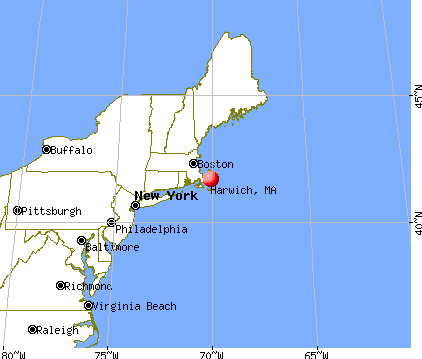
), ), ), ), )Latitude: 41.69 N, Longitude: 70.07 W
Area codes: 774, 508

Harwich, Massachusetts accommodation & food services, waste management - Economy and Business Data
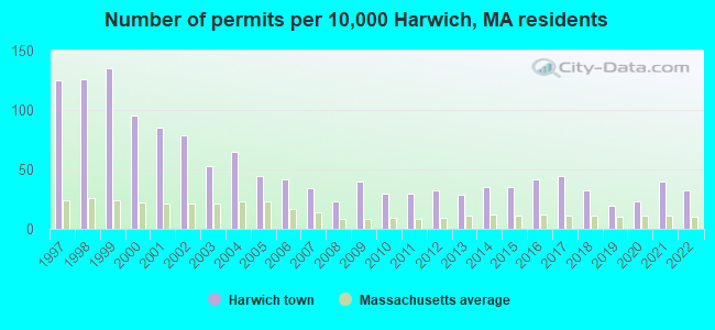
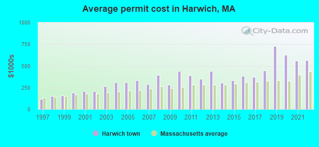
Single-family new house construction building permits:
- 2022: 40 buildings, average cost: $566,500
- 2021: 50 buildings, average cost: $559,800
- 2020: 29 buildings, average cost: $629,400
- 2019: 24 buildings, average cost: $728,700
- 2018: 40 buildings, average cost: $448,600
- 2017: 55 buildings, average cost: $374,800
- 2016: 52 buildings, average cost: $384,300
- 2015: 43 buildings, average cost: $332,100
- 2014: 43 buildings, average cost: $307,200
- 2013: 36 buildings, average cost: $442,400
- 2012: 40 buildings, average cost: $349,800
- 2011: 37 buildings, average cost: $387,700
- 2010: 37 buildings, average cost: $439,800
- 2009: 50 buildings, average cost: $279,900
- 2008: 28 buildings, average cost: $397,500
- 2007: 42 buildings, average cost: $290,000
- 2006: 52 buildings, average cost: $334,200
- 2005: 55 buildings, average cost: $309,900
- 2004: 81 buildings, average cost: $309,000
- 2003: 66 buildings, average cost: $268,000
- 2002: 98 buildings, average cost: $209,900
- 2001: 105 buildings, average cost: $207,900
- 2000: 118 buildings, average cost: $190,000
- 1999: 167 buildings, average cost: $155,500
- 1998: 156 buildings, average cost: $154,800
- 1997: 155 buildings, average cost: $115,800
| Here: | 5.4% |
| Massachusetts: | 3.5% |
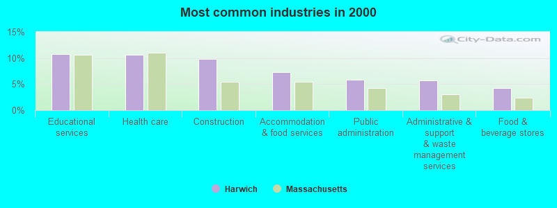
- Educational services (10.7%)
- Health care (10.6%)
- Construction (9.8%)
- Accommodation & food services (7.2%)
- Public administration (5.8%)
- Administrative & support & waste management services (5.7%)
- Food & beverage stores (4.2%)
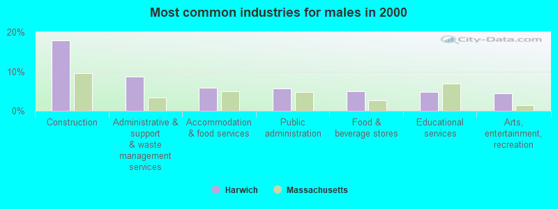
- Construction (17.9%)
- Administrative & support & waste management services (8.7%)
- Accommodation & food services (5.8%)
- Public administration (5.6%)
- Food & beverage stores (5.0%)
- Educational services (4.8%)
- Arts, entertainment, recreation (4.4%)
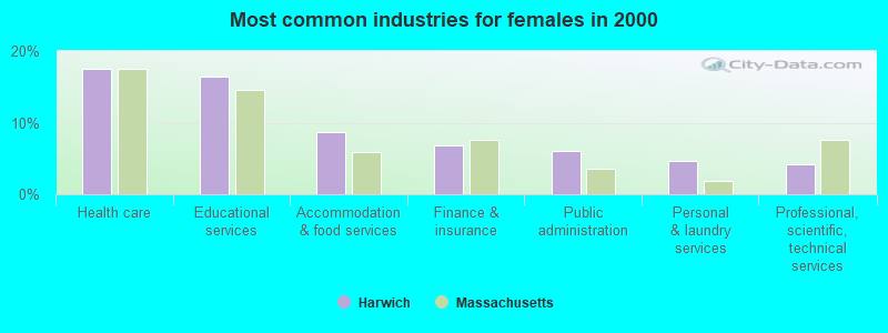
- Health care (17.5%)
- Educational services (16.5%)
- Accommodation & food services (8.7%)
- Finance & insurance (6.8%)
- Public administration (6.0%)
- Personal & laundry services (4.6%)
- Professional, scientific, technical services (4.2%)
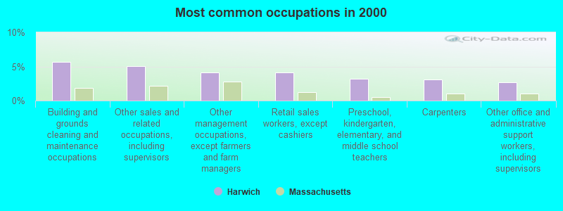
- Building and grounds cleaning and maintenance occupations (5.7%)
- Other sales and related occupations, including supervisors (5.1%)
- Other management occupations, except farmers and farm managers (4.1%)
- Retail sales workers, except cashiers (4.1%)
- Preschool, kindergarten, elementary, and middle school teachers (3.2%)
- Carpenters (3.1%)
- Other office and administrative support workers, including supervisors (2.7%)
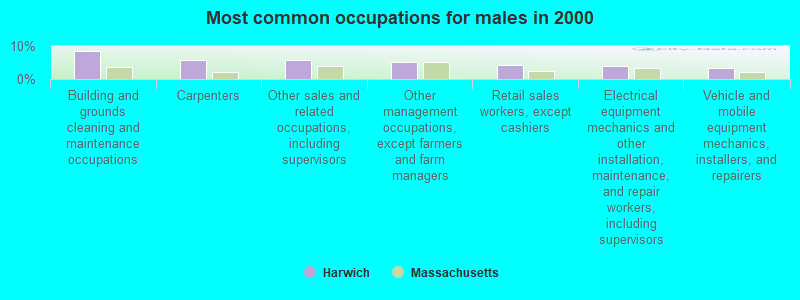
- Building and grounds cleaning and maintenance occupations (8.6%)
- Carpenters (5.8%)
- Other sales and related occupations, including supervisors (5.8%)
- Other management occupations, except farmers and farm managers (5.2%)
- Retail sales workers, except cashiers (4.2%)
- Electrical equipment mechanics and other installation, maintenance, and repair workers, including supervisors (4.1%)
- Vehicle and mobile equipment mechanics, installers, and repairers (3.2%)
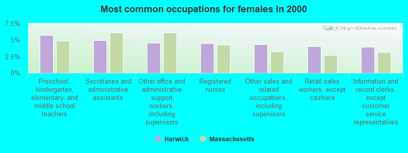
- Preschool, kindergarten, elementary, and middle school teachers (5.7%)
- Secretaries and administrative assistants (5.0%)
- Other office and administrative support workers, including supervisors (4.5%)
- Registered nurses (4.5%)
- Other sales and related occupations, including supervisors (4.4%)
- Retail sales workers, except cashiers (4.1%)
- Information and record clerks, except customer service representatives (4.0%)
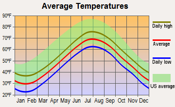
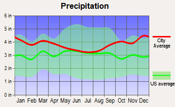
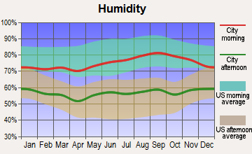
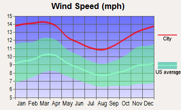
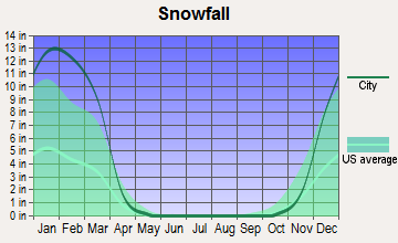
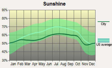
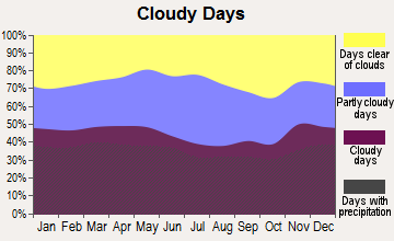
Average climate in Harwich, Massachusetts
Based on data reported by over 4,000 weather stations
(lower is better)
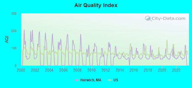
Air Quality Index (AQI) level in 2022 was 48.0. This is significantly better than average.
| City: | 48.0 |
| U.S.: | 72.6 |
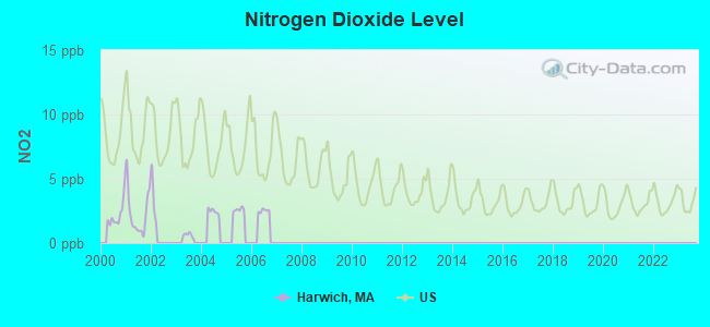
Nitrogen Dioxide (NO2) [ppb] level in 2001 was 2.30. This is significantly better than average. Closest monitor was 19.8 miles away from the city center.
| City: | 2.30 |
| U.S.: | 5.11 |
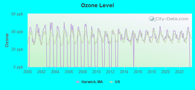
Ozone [ppb] level in 2022 was 34.8. This is about average. Closest monitor was 19.8 miles away from the city center.
| City: | 34.8 |
| U.S.: | 33.3 |
Earthquake activity:
Harwich-area historical earthquake activity is significantly above Massachusetts state average. It is 78% smaller than the overall U.S. average.On 10/16/2012 at 23:12:25, a magnitude 4.7 (4.7 ML, Depth: 10.0 mi, Class: Light, Intensity: IV - V) earthquake occurred 135.1 miles away from Harwich center
On 1/19/1982 at 00:14:42, a magnitude 4.7 (4.5 MB, 4.7 MD, 4.5 LG) earthquake occurred 147.3 miles away from Harwich center
On 10/7/1983 at 10:18:46, a magnitude 5.3 (5.1 MB, 5.3 LG, 5.1 ML, Class: Moderate, Intensity: VI - VII) earthquake occurred 267.1 miles away from Harwich center
On 4/20/2002 at 10:50:47, a magnitude 5.3 (5.3 ML, Depth: 3.0 mi) earthquake occurred 267.5 miles away from Harwich center
On 8/22/1992 at 12:20:32, a magnitude 4.8 (4.8 MB, 3.8 MS, 4.7 LG, Depth: 6.2 mi) earthquake occurred 179.3 miles away from Harwich center
On 4/20/2002 at 10:50:47, a magnitude 5.2 (5.2 MB, 4.2 MS, 5.2 MW, 5.0 MW) earthquake occurred 266.9 miles away from the city center
Magnitude types: regional Lg-wave magnitude (LG), body-wave magnitude (MB), duration magnitude (MD), local magnitude (ML), surface-wave magnitude (MS), moment magnitude (MW)
Natural disasters:
The number of natural disasters in Barnstable County (21) is greater than the US average (15).Major Disasters (Presidential) Declared: 11
Emergencies Declared: 8
Causes of natural disasters: Hurricanes: 7, Floods: 5, Storms: 4, Snows: 3, Snowstorms: 3, Winter Storms: 3, Blizzards: 2, Snowfall: 1, Tropical Storm: 1, Wind: 1, Other: 1 (Note: some incidents may be assigned to more than one category).
Hospitals and medical centers in Harwich:
Other hospitals and medical centers near Harwich:
- BREWSTER MANOR NURSING RET HOME (Nursing Home, about 4 miles away; BREWSTER, MA)
- EPOCH SENIOR HEALTHCARE OF BREWSTER (Nursing Home, about 4 miles away; BREWSTER, MA)
- HOSPICE OF VNA OF CEN AND OUTER CAPE COD (Hospital, about 5 miles away; SOUTH DENNIS, MA)
- PLEASANT BAY NURSING AND REHABILITATION (Nursing Home, about 5 miles away; BREWSTER, MA)
- BROAD REACH HOSPICE (Hospital, about 6 miles away; NORTH CHATHAM, MA)
- LIBERTY COMMONS (Nursing Home, about 6 miles away; NORTH CHATHAM, MA)
- WINDSOR NURSING AND RETIREMENT HOME (Nursing Home, about 6 miles away; SOUTH YARMOUTH, MA)
Colleges/universities with over 2000 students nearest to Harwich:
- Cape Cod Community College (about 14 miles; West Barnstable, MA; Full-time enrollment: 2,491)
- University of Massachusetts-Dartmouth (about 49 miles; North Dartmouth, MA; FT enrollment: 7,545)
- Bridgewater State University (about 51 miles; Bridgewater, MA; FT enrollment: 9,802)
- Bristol Community College (about 55 miles; Fall River, MA; FT enrollment: 5,707)
- Massasoit Community College (about 55 miles; Brockton, MA; FT enrollment: 5,442)
- Stonehill College (about 58 miles; Easton, MA; FT enrollment: 2,563)
- Roger Williams University (about 62 miles; Bristol, RI; FT enrollment: 4,375)
Public high schools in Harwich:
- CAPE COD REGION VOCATIONAL TECHNICAL (Students: 686, Location: 351 PLEASANT LAKE AVENUE, Grades: 9-12)
- MONOMOY REGIONAL HIGH SCHOOL (Location: 75 OAK STREET, Grades: 8-12)
Public elementary/middle school in Harwich:
- HARWICH ELEMENTARY SCHOOL (Students: 672, Location: 263 SOUTH STREET, Grades: PK-4)
User-submitted facts and corrections:
- Falmouth Hospital, Falmouth
- Cape Cod Community College (appox. 20 miles from Harwich)
Points of interest:
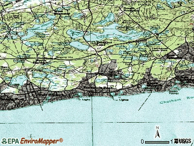
Notable locations in Harwich: Sand Pond (A), Harwich Fire Department Station 2 (B), Harwich Fire Department Station 1 Headquarters (C), Harwich Elementary School Library Media Center (D), Cape Cod Regional Technical High School Library (E), Bay Path Regional Vocational Technical High School Media Center (F), Brooks Library (G), North Harwich Station (H). Display/hide their locations on the map
Shopping Center: 333 Main Street Shopping Center (1). Display/hide its location on the map
Church in Harwich: Congregational Church (A). Display/hide its location on the map
Cemeteries: Evergreen Cemetery (1), Pine Grove Cemetery (2), Island Pond Cemetery (3), Mount Pleasant Cemetery (4). Display/hide their locations on the map
Lakes, reservoirs, and swamps: Walkers Pond (A), Skinequit Pond (B), Seymour Pond (C), Sand Pond (D), Robbins Pond (E), Paddocks Pond (F), Olivers Pond (G), Mud Pond (H). Display/hide their locations on the map
Rivers: Andrews River (A), Herring River (B). Display/hide their locations on the map
Park in Harwich: Hawksnest State Park (1). Display/hide its location on the map
Beaches: Pleasant Road Beach (A), Red River Beach (B), Earle Road Beach (C). Display/hide their locations on the map
Tourist attractions: Brooks Academy Museum (80 Parallel Street) (1), Harwich Historical Society (Cultural Attractions- Events- & Facilities; 80 Parallel Street) (2), Cape Destinations (Tours & Charters; 71 Main St) (3). Display/hide their approximate locations on the map
Birthplace of: Seth Doane - Television reporter, Shirley Gomes - Politician.
Drinking water stations with addresses in Harwich that have no violations reported:
- HARWICH WATER DEPARTMENT (Population served: 38,000, Primary Water Source Type: Groundwater)
| This town: | 2.1 people |
| Massachusetts: | 2.5 people |
| This town: | 60.9% |
| Whole state: | 63.0% |
| This town: | 5.7% |
| Whole state: | 7.0% |
Likely homosexual households (counted as self-reported same-sex unmarried-partner households)
- Lesbian couples: 0.9% of all households
- Gay men: 0.7% of all households
| This town: | 5.5% |
| Whole state: | 9.3% |
| This town: | 2.2% |
| Whole state: | 4.4% |
People in group quarters in Harwich in 2010:
- 145 people in nursing facilities/skilled-nursing facilities
- 12 people in group homes intended for adults
- 9 people in residential treatment centers for adults
- 3 people in other noninstitutional facilities
People in group quarters in Harwich in 2000:
- 288 people in nursing homes
- 14 people in schools, hospitals, or wards for the intellectually disabled
- 12 people in other noninstitutional group quarters
- 7 people in homes for the mentally ill
- 6 people in residential treatment centers for emotionally disturbed children
- 3 people in other group homes
- 3 people in other nonhousehold living situations
For population 15 years and over in Harwich:
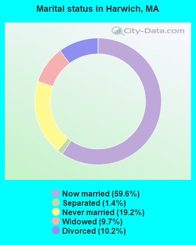
- Never married: 19.2%
- Now married: 59.6%
- Separated: 1.4%
- Widowed: 9.7%
- Divorced: 10.2%
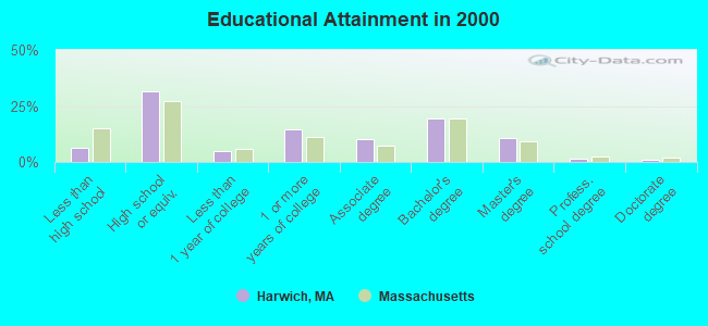
For population 25 years and over in Harwich:
- High school or higher: 93.7%
- Bachelor's degree or higher: 32.4%
- Graduate or professional degree: 13.2%
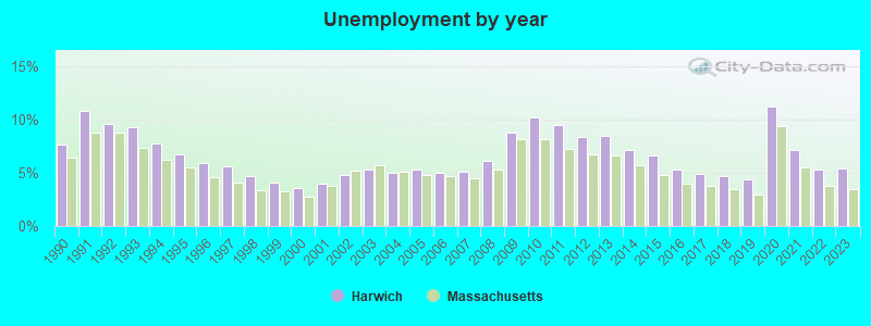
- Unemployed: 4.3%
- Mean travel time to work (commute): 21.2 minutes
| Here: | 9.8 |
| Massachusetts average: | 13.1 |
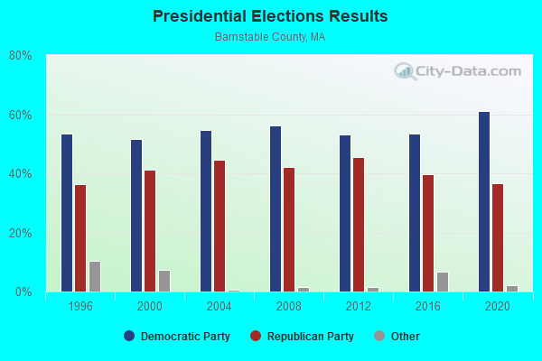
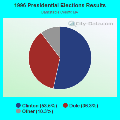
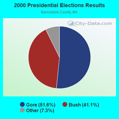

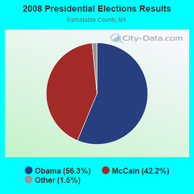

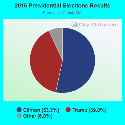
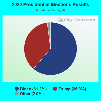
Graphs represent county-level data. Detailed 2008 Election Results
Religion statistics for Harwich, MA (based on Barnstable County data)
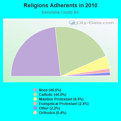
| Religion | Adherents | Congregations |
|---|---|---|
| Catholic | 86,370 | 18 |
| Mainline Protestant | 18,165 | 68 |
| Evangelical Protestant | 5,281 | 46 |
| Other | 4,734 | 32 |
| Orthodox | 810 | 3 |
| None | 100,528 | - |
Food Environment Statistics:
| Barnstable County: | 3.06 / 10,000 pop. |
| State: | 1.98 / 10,000 pop. |
| Barnstable County: | 0.05 / 10,000 pop. |
| State: | 0.05 / 10,000 pop. |
| Barnstable County: | 3.38 / 10,000 pop. |
| Massachusetts: | 2.22 / 10,000 pop. |
| Barnstable County: | 2.57 / 10,000 pop. |
| Massachusetts: | 1.77 / 10,000 pop. |
| This county: | 18.60 / 10,000 pop. |
| Massachusetts: | 8.76 / 10,000 pop. |
| Barnstable County: | 7.9% |
| Massachusetts: | 8.1% |
| Barnstable County: | 19.6% |
| Massachusetts: | 22.5% |
| Here: | 13.8% |
| Massachusetts: | 16.5% |
| Businesses in Harwich, MA | ||||
| Name | Count | Name | Count | |
|---|---|---|---|---|
| CVS | 1 | Nike | 1 | |
| Dunkin Donuts | 3 | Starbucks | 1 | |
| FedEx | 1 | Stop & Shop | 1 | |
| Goodwill | 2 | Talbots | 1 | |
Strongest AM radio stations in Harwich:
- WFPB (1170 AM; daytime; 1 kW; ORLEANS, MA; Owner: UNIVERSITY OF MASSACHUSETTS)
- WBZ (1030 AM; 50 kW; BOSTON, MA; Owner: INFINITY BROADCASTING OPERATIONS, INC.)
- WRKO (680 AM; 50 kW; BOSTON, MA; Owner: ENTERCOM BOSTON LICENSE, LLC)
- WEEI (850 AM; 50 kW; BOSTON, MA; Owner: ENTERCOM BOSTON LICENSE, LLC)
- WBUR (1240 AM; 1 kW; WEST YARMOUTH, MA; Owner: THE EXEC. COMM. OF TRTS. BOSTON U)
- WALE (990 AM; 50 kW; GREENVILLE, RI; Owner: NORTH AMERICAN BROADCASTING CO., INC.)
- WKOX (1200 AM; 50 kW; FRAMINGHAM, MA; Owner: CAPSTAR TX LIMITED PARTNERSHIP)
- WWZN (1510 AM; 50 kW; BOSTON, MA; Owner: ROSE CITY RADIO CORPORATION)
- WBIX (1060 AM; 40 kW; NATICK, MA; Owner: LANGER BROADCASTING CORPORATION)
- WCRN (830 AM; 50 kW; WORCESTER, MA; Owner: CARTER BROADCASTING CORPORATION)
- WAMG (890 AM; 25 kW; DEDHAM, MA; Owner: MEGA COMMUNICATIONS OF DEDHAM LICENSEE, LLC)
- WNNZ (640 AM; 50 kW; WESTFIELD, MA; Owner: CLEAR CHANNEL BROADCASTING LICENSES, INC.)
- WRCA (1330 AM; 25 kW; WALTHAM, MA; Owner: WRCA LICENSE, LLC)
Strongest FM radio stations in Harwich:
- WCCT-FM (90.3 FM; HARWICH, MA; Owner: CAPE COD REGIONAL TECH HIGH SCHOOL)
- WOCN-FM (103.9 FM; SOUTH YARMOUTH, MA; Owner: SANDAB COMMUNICATIONS LTD. PARTNERSHIP II)
- WFCC-FM (107.5 FM; CHATHAM, MA; Owner: CHARLES RIVER B/CING WFCC LIC. CORP.)
- WDVT (93.5 FM; HARWICH PORT, MA; Owner: BOCH BROADCASTING, L.P.)
- WCOD-FM (106.1 FM; HYANNIS, MA; Owner: BOCH BROADCASTING, L.P.)
- WKPE-FM (104.7 FM; ORLEANS, MA; Owner: CRB WKPE LIC CORP.)
- WXTK (95.1 FM; WEST YARMOUTH, MA; Owner: BOCH BROADCASTING LTD. PARTNERSHIP)
- WPXC (102.9 FM; HYANNIS, MA; Owner: QANTUM OF CAPE COD LICENSE COMPANY, LLC)
- WQRC (99.9 FM; BARNSTABLE, MA; Owner: SANDAB COMMUNICATION LTD. PNR/SHP II)
- WCIB (101.9 FM; FALMOUTH, MA; Owner: QANTUM OF CAPE COD LICENSE COMPANY, LLC)
- WKKL (90.7 FM; WEST BARNSTABLE, MA; Owner: CAPE COD COMMUNITY COLLEGE)
TV broadcast stations around Harwich:
- W08CH (Channel 8; HYANNIS, MA; Owner: WGBH EDUCATIONAL FOUNDATION)
- WDPX (Channel 58; VINEYARD HAVEN, MA; Owner: PAXSON BOSTON-68 LICENSE, INC.)
- WMPX-LP (Channel 67; DENNIS, MA; Owner: PAXSON BOSTON-68 LICENSE, INC.)
- National Bridge Inventory (NBI) Statistics
- 8Number of bridges
- 85ft / 25.9mTotal length
- $20,922,000Total costs
- 100,336Total average daily traffic
- 5,663Total average daily truck traffic
- 198,280Total future (year 2031) average daily traffic
FCC Registered Cell Phone Towers:
1 (See the full list of FCC Registered Cell Phone Towers in Harwich)FCC Registered Antenna Towers:
10 (See the full list of FCC Registered Antenna Towers)FCC Registered Broadcast Land Mobile Towers:
8 (See the full list of FCC Registered Broadcast Land Mobile Towers in Harwich, MA)FCC Registered Microwave Towers:
7- HARWICH, Queen Ann Rd (Lat: 41.698444 Lon: -70.097806), Type: Tower, Structure height: 42.7 m, Overall height: 46.3 m, Call Sign: WLW641,
Assigned Frequencies: 6063.80 MHz, 10563.1 MHz, 10602.5 MHz, 11385.0 MHz, 10562.5 MHz, Grant Date: 01/11/2011, Expiration Date: 02/01/2021, Cancellation Date: 08/29/2012, Registrant: Verizon Wireless, 1120 Sanctuary Pkwy, #150 Gasa5reg, Alpharetta, GA 30009-7630, Phone: (770) 797-1070, Fax: (770) 797-1036, Email:
- HARWICH, Queen Ann Road (Lat: 41.698417 Lon: -70.097778), Overall height: 46.3 m, Call Sign: WMK533,
Assigned Frequencies: 10551.2 MHz, Grant Date: 04/12/1995, Expiration Date: 02/01/2001, Cancellation Date: 09/10/1996, Registrant: Cape And Islands Cellular Limited Partnership, 180 Washington Valley Rd, Bedminster, NJ 07921
- HARWICH, 198 Queen Anne Rd (Lat: 41.698528 Lon: -70.097194), Type: Mast, Structure height: 43.3 m, Overall height: 44.8 m, Call Sign: WMT440,
Assigned Frequencies: 10592.5 MHz, Grant Date: 01/11/2011, Expiration Date: 02/01/2021, Cancellation Date: 05/11/2017, Certifier: Carol L Tacker, Registrant: At&t Mobility LLC, 1120 20th Street, Nw - Suite 1000, Washington, DC 20036, Phone: (202) 457-2055, Fax: (202) 457-3073, Email:
- STATION, 146 Chatham Rd (Lat: 41.681500 Lon: -70.051667), Overall height: 25.3 m, Call Sign: WNTU209,
Assigned Frequencies: 952.356 MHz, 928.356 MHz, Grant Date: 10/27/1998, Expiration Date: 01/25/2009, Cancellation Date: 03/28/2009, Phone: (508) 394-2405
- Harwich WT, 2nd Street (Lat: 41.710139 Lon: -70.071750), Type: Tank, Structure height: 42.6 m, Call Sign: WQPX477,
Assigned Frequencies: 11345.0 MHz, 11015.0 MHz, 11345.0 MHz, 11015.0 MHz, 11345.0 MHz, 11015.0 MHz, 11015.0 MHz, 11015.0 MHz, 11015.0 MHz, Grant Date: 09/10/2012, Expiration Date: 09/10/2022, Cancellation Date: 11/12/2022, Certifier: Dan Gallagher, Registrant: Radyn, Inc, Silver Spring, MD 20914, Phone: (301) 493-5171, Fax: (301) 576-4553, Email:
- HYN0009, 190 Queen Ann Road (Lat: 41.698556 Lon: -70.097917), Type: Ltower, Structure height: 48.8 m, Call Sign: WQRI552,
Assigned Frequencies: 11605.0 MHz, 17830.0 MHz, 21830.0 MHz, 11605.0 MHz, 17830.0 MHz, 21830.0 MHz, 11605.0 MHz, 17830.0 MHz, 21830.0 MHz, 11605.0 MHz... (+5 more), Grant Date: 05/21/2013, Expiration Date: 05/21/2023, Cancellation Date: 06/23/2014, Certifier: Dan Menser, Registrant: T-Mobile License LLC, 12920 Se 38th Street, Bellevue, WA 98006, Phone: (425) 383-8401, Fax: (425) 383-4840, Email:
- Harwich WT, 2nd Street (Lat: 41.710139 Lon: -70.071750), Type: Tank, Structure height: 42.6 m, Call Sign: WRXN847, Licensee ID: L01721556,
Assigned Frequencies: 11015.0 MHz, 11345.0 MHz, 11015.0 MHz, 11345.0 MHz, 11015.0 MHz, 11345.0 MHz, 11015.0 MHz, 11015.0 MHz, 11015.0 MHz, Grant Date: 06/05/2023, Expiration Date: 06/05/2033, Certifier: Jennifer Brann, Registrant: Opencape Corporation, 3195 Main Street, Barnstable, MA 02630, Phone: (508) 362-2224, Fax: (508) 362-0454, Email:
FCC Registered Amateur Radio Licenses:
73 (See the full list of FCC Registered Amateur Radio Licenses in Harwich)FAA Registered Aircraft:
4- Aircraft: MOONEY AIRCRAFT CORP. M20K (Category: Land, Seats: 4, Weight: Up to 12,499 Pounds), Engine: CONT MOTOR TSIO-360 SER (225 HP) (Reciprocating)
N-Number: 3594H, N3594H, N-3594H, Serial Number: 25-0428, Year manufactured: 1980, Airworthiness Date: 09/16/1980, Certificate Issue Date: 05/08/2019
Registrant (LLC): Kilo Sierra LLC, Po Box 1203, Harwich, MA 02645 - Aircraft: BEECH F33A (Category: Land, Seats: 5, Weight: Up to 12,499 Pounds, Speed: 138 mph), Engine: CONT MOTOR IO 520 SERIES (285 HP) (Reciprocating)
N-Number: 8299G, N8299G, N-8299G, Serial Number: CE-1749, Year manufactured: 1993, Airworthiness Date: 08/27/1993, Certificate Issue Date: 11/19/2019
Registrant (Individual): Richard P Houghtaling, 27 Wilma's Way, Harwich, MA 02645 - Aircraft: CSP LEASING LLC CAVALON (Category: Land, Seats: 2, Weight: Up to 12,499 Pounds), Engine: ROTAX 914UL (115 HP) (4 Cycle)
N-Number: 27JB, N27JB, N-27JB, Serial Number: V00260, Year manufactured: 2016, Airworthiness Date: 09/20/2016, Certificate Issue Date: 12/06/2017
Registrant (Corporation): Cape Gyro Inc, 14 Crestview Dr, Harwich, MA 02645 - Aircraft: CSP LEASING LLC CAVALON (Category: Land, Seats: 2, Weight: Up to 12,499 Pounds), Engine: ROTAX 914UL (115 HP) (4 Cycle)
N-Number: 619KT, N619KT, N-619KT, Serial Number: V00260, Year manufactured: 2016, Airworthiness Date: 09/20/2016, Certificate Issue Date: 12/06/2017
Registrant (Corporation): Cape Gyro Inc, 14 Crestview Dr, Harwich, MA 02645
2002 - 2018 National Fire Incident Reporting System (NFIRS) incidents
- Fire incident types reported to NFIRS in Harwich, MA
- 56253.8%Structure Fires
- 31830.5%Outside Fires
- 12011.5%Mobile Property/Vehicle Fires
- 444.2%Other
 According to the data from the years 2002 - 2018 the average number of fire incidents per year is 61. The highest number of fire incidents - 81 took place in 2006, and the least - 37 in 2018. The data has a declining trend.
 When looking into fire subcategories, the most incidents belonged to: Structure Fires (53.8%), and Outside Fires (30.5%).
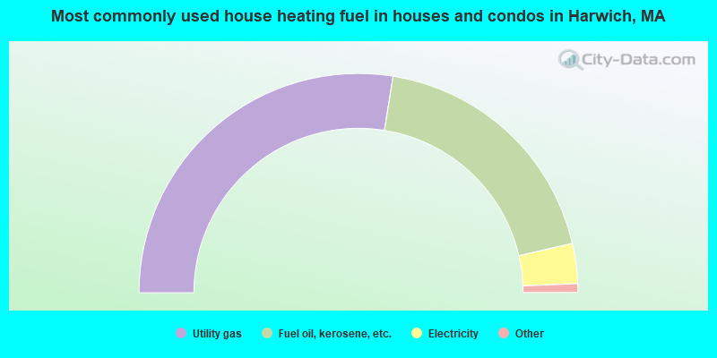
- 55.1%Utility gas
- 37.8%Fuel oil, kerosene, etc.
- 5.9%Electricity
- 0.6%Wood
- 0.5%Bottled, tank, or LP gas
- 0.2%Coal or coke
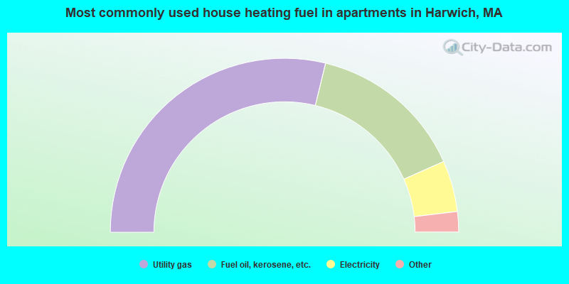
- 57.6%Utility gas
- 29.1%Fuel oil, kerosene, etc.
- 9.5%Electricity
- 1.3%Bottled, tank, or LP gas
- 1.0%Other fuel
- 0.7%Coal or coke
- 0.7%No fuel used
Harwich compared to Massachusetts state average:
- Unemployed percentage significantly below state average.
- Black race population percentage significantly below state average.
- Hispanic race population percentage significantly below state average.
- Median age significantly above state average.
- Foreign-born population percentage significantly below state average.
- Renting percentage below state average.
- Length of stay since moving in significantly above state average.
- Number of rooms per house significantly below state average.
- House age significantly below state average.
- Number of college students below state average.
Harwich on our top lists:
- #27 on the list of "Top 101 cities with largest percentage of females in industries: personal and laundry services (population 5,000+)"
- #35 on the list of "Top 101 cities with largest percentage of males in occupations: carpenters (population 5,000+)"
- #35 on the list of "Top 101 cities with largest percentage of males in industries: food and beverage stores (population 5,000+)"
- #36 on the list of "Top 101 cities with largest percentage of males in industries: building material and garden equipment and supplies dealers (population 5,000+)"
- #38 on the list of "Top 101 cities with largest percentage of males in occupations: other food preparation and serving workers including supervisors (population 5,000+)"
- #44 on the list of "Top 101 cities with largest percentage of males in occupations: art and design workers (population 5,000+)"
- #46 on the list of "Top 101 cities with largest percentage of females in occupations: supervisors and other personal care and service workers except personal appearance, transportation, and child care workers (population 5,000+)"
- #48 on the list of "Top 101 cities with largest percentage of males in industries: used merchandise, gift, novelty, and souvenir, and other miscellaneous stores (population 5,000+)"
- #49 on the list of "Top 101 cities with largest percentage of males in industries: pharmacies and drug stores (population 5,000+)"
- #50 on the list of "Top 101 cities with largest percentage of males in occupations: secondary school teachers (population 5,000+)"
- #57 on the list of "Top 101 cities with largest percentage of females in occupations: personal appearance workers (population 5,000+)"
- #66 on the list of "Top 101 cities with largest percentage of males in industries: gasoline stations (population 5,000+)"
- #66 on the list of "Top 101 cities with largest percentage of females in industries: retail florists (population 5,000+)"
- #66 on the list of "Top 101 cities with largest percentage of females in industries: used merchandise, gift, novelty, and souvenir, and other miscellaneous stores (population 5,000+)"
- #71 on the list of "Top 101 cities with largest percentage of males in industries: alcoholic beverages merchant wholesalers (population 5,000+)"
- #85 on the list of "Top 101 cities with largest percentage of females in industries: furniture and home furnishings, and household appliance stores (population 5,000+)"
- #87 on the list of "Top 101 cities with largest percentage of males in industries: petroleum and petroleum products merchant wholesalers (population 5,000+)"
- #94 on the list of "Top 101 cities with the largest percentage of likely homosexual households (counted as self-reported same-sex unmarried-partner households) (population 5,000+)"
- #100 on the list of "Top 101 cities with largest percentage of males in industries: water transportation (population 5,000+)"
- #1 on the list of "Top 101 counties with the highest percentage of residents that smoked 100+ cigarettes in their lives"
- #7 on the list of "Top 101 counties with the lowest number of births per 1000 residents 2007-2013"
- #9 on the list of "Top 101 counties with the highest percentage of residents that visited a dentist within the past year"
- #10 on the list of "Top 101 counties with the lowest average weight of females"
- #24 on the list of "Top 101 counties with the largest number of people without health insurance coverage in 2000 (pop. 50,000+)"

|
|
Total of 12 patent applications in 2008-2024.