Hillsborough, New Hampshire
Submit your own pictures of this place and show them to the world
- OSM Map
- General Map
- Google Map
- MSN Map
Population change since 2000: +7.3%
| Males: 938 | |
| Females: 1,038 |
| Median resident age: | 50.2 years |
| New Hampshire median age: | 43.3 years |
Zip codes: 03244.
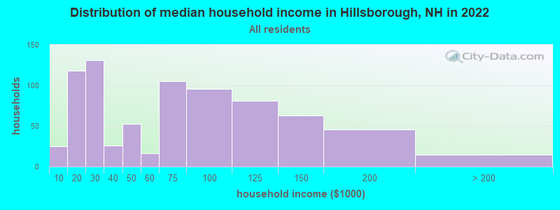
| Hillsborough: | $65,068 |
| NH: | $89,992 |
Estimated per capita income in 2022: $37,094 (it was $19,125 in 2000)
Hillsborough CDP income, earnings, and wages data
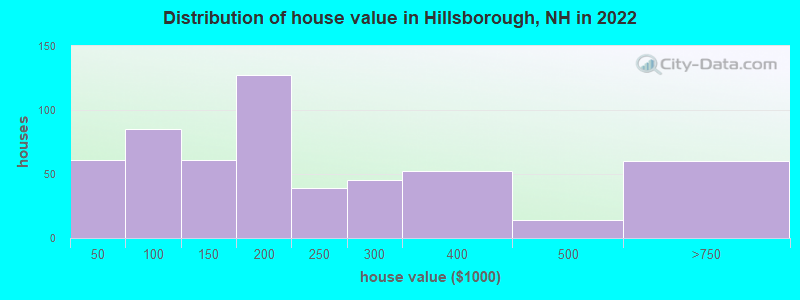
Estimated median house or condo value in 2022: $214,046 (it was $89,900 in 2000)
| Hillsborough: | $214,046 |
| NH: | $384,700 |
Mean prices in 2022: all housing units: $411,252; detached houses: $441,251; townhouses or other attached units: $283,002; in 2-unit structures: $347,377; in 3-to-4-unit structures: $666,663; in 5-or-more-unit structures: $275,798; mobile homes: $132,093
(8.5% for White Non-Hispanic residents, 3.9% for two or more races residents)
Detailed information about poverty and poor residents in Hillsborough, NH
Compare current foreclosures near Hillsborough, NH:
| Photo | Address | Area | Beds / Baths | Price | Details |
|---|---|---|---|---|---|

|
#1
Jolly Farm Rd
Bradford, NH 03221
|
- sq. feet
|
1 baths 3 beds |
show details | |

|
#2
Forest St
Bradford, NH 03221
|
1,009 sq. feet
|
1 baths 2 beds |
show details | |

|
#3
Church St
Goffstown, NH 03045
|
2,115 sq. feet
|
2 baths 4 beds |
show details | |

|
#4
Portsmouth St
Concord, NH 03301
|
1,184 sq. feet
|
2 baths 3 beds |
show details | |

|
#5
Pinewood Dr
Contoocook, NH 03229
|
2,157 sq. feet
|
2 baths 3 beds |
show details | |

|
#6
Forest St
Bradford, NH 03221
|
1,152 sq. feet
|
1 baths 3 beds |
show details | |

|
#7
Tenney Hill Rd
Dunbarton, NH 03046
|
1,906 sq. feet
|
1 baths 2 beds |
show details | |

|
#8
Duck Pond Ln
Warner, NH 03278
|
1,120 sq. feet
|
1 baths 3 beds |
show details | |

|
#9
Van Ger Dr
Bow, NH 03304
|
2,498 sq. feet
|
2 baths 3 beds |
show details | |

|
#10
Lakeview Dr
Weare, NH 03281
|
- sq. feet
|
2 baths 3 beds |
show details |
| Photo | Address | Area | Beds / Baths | Price | Details |
|---|---|---|---|---|---|

|
#11
Holly Hill Farm Rd
Weare, NH 03281
|
- sq. feet
|
2 baths 3 beds |
show details | |

|
#12
Hemlock St
Hillsboro, NH 03244
|
- sq. feet
|
2 baths 4 beds |
show details | |

|
#13
Mill St
New Boston, NH 03070
|
- sq. feet
|
3 baths 4 beds |
show details | |

|
#14
Mary Rowe Dr
Hillsboro, NH 03244
|
- sq. feet
|
2 baths 2 beds |
show details | |

|
#15
Whitney Rd
Hillsboro, NH 03244
|
- sq. feet
|
2 baths 3 beds |
show details | |

|
#16
Francestown Rd
Bennington, NH 03442
|
- sq. feet
|
1 baths 2 beds |
show details | |

|
#17
Reed St Apt 105
Goffstown, NH 03045
|
- sq. feet
|
- baths - beds |
show details | |

|
#18
Gary Rd
Dunbarton, NH 03046
|
- sq. feet
|
- baths - beds |
show details | |

|
#19
Depot St Apt 3
Hillsboro, NH 03244
|
- sq. feet
|
- baths - beds |
show details | |

|
#20
High St
Bradford, NH 03221
|
- sq. feet
|
- baths - beds |
show details |
| Photo | Address | Area | Beds / Baths | Price | Details |
|---|---|---|---|---|---|

|
#21
Cross Rd
Henniker, NH 03242
|
- sq. feet
|
- baths - beds |
show details | |

|
#22
Deering Center Rd
Hillsboro, NH 03244
|
- sq. feet
|
- baths - beds |
show details | |

|
#23
Seminole Rd
Hillsboro, NH 03244
|
- sq. feet
|
- baths - beds |
show details | |

|
#24
School St Ste 211
Bennington, NH 03442
|
- sq. feet
|
- baths - beds |
show details | |

|
#25
Childs Way
Hillsboro, NH 03244
|
- sq. feet
|
- baths - beds |
show details | |

|
#26
County Rd
Bradford, NH 03221
|
- sq. feet
|
- baths - beds |
show details | |

|
#27
Ski Tow Rd
Weare, NH 03281
|
- sq. feet
|
- baths - beds |
show details | |

|
#28
Brookmeadow Ln
Warner, NH 03278
|
- sq. feet
|
- baths - beds |
show details | |

|
#29
Granite Lake Rd
Nelson, NH 03457
|
- sq. feet
|
- baths - beds |
show details | |

|
#30
Ayers Pond Rd
Washington, NH 03280
|
- sq. feet
|
- baths - beds |
show details |
| Photo | Address | Area | Beds / Baths | Price | Details |
|---|---|---|---|---|---|

|
#31
Murdough Hill Rd
Nelson, NH 03457
|
- sq. feet
|
- baths - beds |
show details | |

|
#32
Battle St
Concord, NH 03303
|
- sq. feet
|
- baths - beds |
show details | |

|
#33
Masquanipi Dr
Antrim, NH 03440
|
- sq. feet
|
- baths - beds |
show details | |

|
#34
Glen Dr
Peterborough, NH 03458
|
- sq. feet
|
- baths - beds |
show details | |

|
#35
Slip Rd
Greenfield, NH 03047
|
- sq. feet
|
- baths - beds |
show details | |

|
#36
Farrell Loop
Warner, NH 03278
|
- sq. feet
|
- baths - beds |
show details | |

|
#37
Longview Rd
Hancock, NH 03449
|
- sq. feet
|
- baths - beds |
show details | |

|
Check over 1 million property listings on Foreclosure.com!
|
browse all offers | |||


- 1,28181.0%White alone
- 26316.6%Two or more races
- 754.7%Hispanic
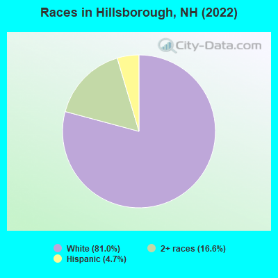
Races in Hillsborough detailed stats: ancestries, foreign born residents, place of birth
According to our research of New Hampshire and other state lists, there were 10 registered sex offenders living in Hillsborough, New Hampshire as of April 27, 2024.
The ratio of all residents to sex offenders in Hillsborough is 205 to 1.
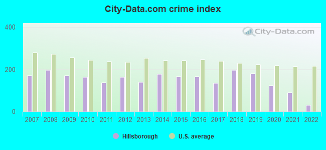
Type |
2009 |
2010 |
2011 |
2012 |
2013 |
2014 |
2015 |
2016 |
2017 |
2018 |
2019 |
2020 |
2021 |
2022 |
|---|---|---|---|---|---|---|---|---|---|---|---|---|---|---|
| Murders (per 100,000) | 0 (0.0) | 0 (0.0) | 0 (0.0) | 0 (0.0) | 0 (0.0) | 0 (0.0) | 0 (0.0) | 0 (0.0) | 0 (0.0) | 1 (16.8) | 1 (16.7) | 0 (0.0) | 0 (0.0) | 0 (0.0) |
| Rapes (per 100,000) | 2 (35.6) | 3 (49.9) | 2 (33.2) | 4 (66.2) | 2 (33.4) | 6 (99.5) | 7 (118.8) | 4 (67.0) | 3 (50.4) | 5 (84.2) | 6 (100.2) | 4 (66.7) | 4 (66.4) | 1 (16.8) |
| Robberies (per 100,000) | 0 (0.0) | 1 (16.6) | 0 (0.0) | 1 (16.6) | 0 (0.0) | 0 (0.0) | 0 (0.0) | 1 (16.7) | 1 (16.8) | 2 (33.7) | 0 (0.0) | 1 (16.7) | 0 (0.0) | 1 (16.8) |
| Assaults (per 100,000) | 4 (71.2) | 8 (133.1) | 6 (99.7) | 6 (99.4) | 11 (183.5) | 5 (82.9) | 4 (67.9) | 12 (200.9) | 9 (151.2) | 7 (117.9) | 6 (100.2) | 6 (100.0) | 2 (33.2) | 1 (16.8) |
| Burglaries (per 100,000) | 22 (391.6) | 19 (316.1) | 14 (232.6) | 10 (165.6) | 12 (200.2) | 23 (381.4) | 16 (271.5) | 16 (267.8) | 13 (218.3) | 14 (235.8) | 13 (217.0) | 12 (200.0) | 3 (49.8) | 0 (0.0) |
| Thefts (per 100,000) | 131 (2,332) | 92 (1,531) | 107 (1,778) | 97 (1,606) | 91 (1,518) | 71 (1,177) | 51 (865.3) | 56 (937.4) | 62 (1,041) | 58 (977.1) | 41 (684.5) | 39 (649.9) | 30 (498.3) | 9 (150.8) |
| Auto thefts (per 100,000) | 5 (89.0) | 6 (99.8) | 3 (49.8) | 8 (132.5) | 2 (33.4) | 6 (99.5) | 2 (33.9) | 9 (150.7) | 2 (33.6) | 6 (101.1) | 4 (66.8) | 4 (66.7) | 5 (83.1) | 2 (33.5) |
| Arson (per 100,000) | 3 (53.4) | 3 (49.9) | 1 (16.6) | 1 (16.6) | 0 (0.0) | 0 (0.0) | 0 (0.0) | 1 (16.7) | 0 (0.0) | 0 (0.0) | 1 (16.7) | 0 (0.0) | 1 (16.6) | 1 (16.8) |
| City-Data.com crime index | 170.5 | 162.9 | 137.9 | 164.3 | 140.8 | 177.9 | 164.9 | 167.1 | 135.2 | 198.5 | 181.5 | 123.6 | 89.9 | 30.5 |
The City-Data.com crime index weighs serious crimes and violent crimes more heavily. Higher means more crime, U.S. average is 246.1. It adjusts for the number of visitors and daily workers commuting into cities.
Crime rate in Hillsborough detailed stats: murders, rapes, robberies, assaults, burglaries, thefts, arson
Full-time law enforcement employees in 2021, including police officers: 23 (15 officers - 13 male; 2 female).
| Officers per 1,000 residents here: | 2.49 |
| New Hampshire average: | 2.14 |
 Recent articles from our blog. Our writers, many of them Ph.D. graduates or candidates, create easy-to-read articles on a wide variety of topics.


Latest news from Hillsborough, NH collected exclusively by city-data.com from local newspapers, TV, and radio stations
Ancestries: English (44.6%), Greek (9.2%), American (8.9%), French (6.9%), German (6.9%), Polish (5.9%).
Current Local Time: EST time zone
Incorporated in 1772
Land area: 1.63 square miles.
Population density: 1,213 people per square mile (low).
15 residents are foreign born
| This place: | 0.9% |
| New Hampshire: | 6.0% |
Median real estate property taxes paid for housing units with mortgages in 2022: $5,306 (2.8%)
Median real estate property taxes paid for housing units with no mortgage in 2022: $4,460 (2.0%)
Nearest city with pop. 50,000+: Manchester, NH  (24.2 miles , pop. 107,006).
Nearest city with pop. 200,000+: Boston, MA (68.5 miles , pop. 589,141).
Nearest city with pop. 1,000,000+: Bronx, NY (186.9 miles , pop. 1,332,650).
Nearest cities:
), )Latitude: 43.12 N, Longitude: 71.90 W
Area code commonly used in this area: 603

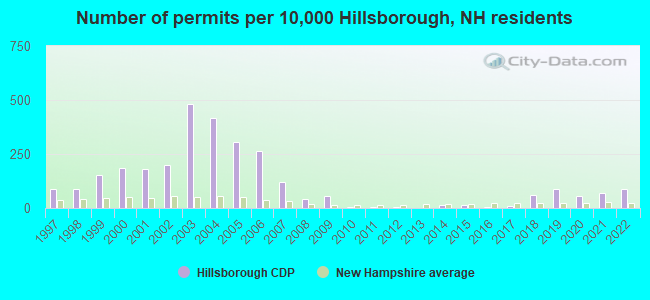
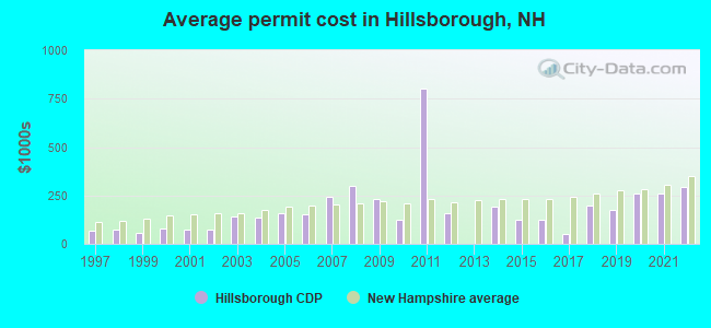
Single-family new house construction building permits:
- 2022: 16 buildings, average cost: $294,200
- 2021: 13 buildings, average cost: $260,600
- 2020: 10 buildings, average cost: $260,000
- 2019: 16 buildings, average cost: $175,000
- 2018: 11 buildings, average cost: $197,500
- 2017: 2 buildings, average cost: $50,000
- 2016: 1 building, cost: $126,300
- 2015: 3 buildings, average cost: $126,300
- 2014: 3 buildings, average cost: $194,000
- 2012: 1 building, cost: $160,000
- 2011: 1 building, cost: $800,000
- 2010: 1 building, cost: $125,000
- 2009: 10 buildings, average cost: $231,500
- 2008: 8 buildings, average cost: $301,300
- 2007: 22 buildings, average cost: $243,900
- 2006: 49 buildings, average cost: $153,800
- 2005: 56 buildings, average cost: $158,000
- 2004: 77 buildings, average cost: $135,400
- 2003: 89 buildings, average cost: $141,400
- 2002: 37 buildings, average cost: $75,400
- 2001: 33 buildings, average cost: $74,900
- 2000: 34 buildings, average cost: $77,800
- 1999: 28 buildings, average cost: $54,000
- 1998: 16 buildings, average cost: $73,100
- 1997: 16 buildings, average cost: $66,700
| Here: | 2.6% |
| New Hampshire: | 2.5% |
- Health care (11.9%)
- Accommodation & food services (11.5%)
- Educational services (9.5%)
- Electrical equipment, appliances, components (5.8%)
- Transportation equipment (5.4%)
- Department & other general merchandise stores (4.7%)
- Paper (4.0%)
- Accommodation & food services (12.4%)
- Transportation equipment (7.6%)
- Paper (7.4%)
- Department & other general merchandise stores (7.4%)
- Electrical equipment, appliances, components (7.2%)
- Health care (6.6%)
- Educational services (5.2%)
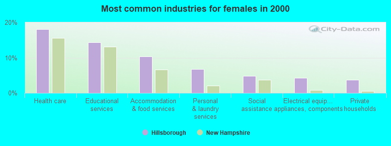
- Health care (18.1%)
- Educational services (14.4%)
- Accommodation & food services (10.3%)
- Personal & laundry services (6.8%)
- Social assistance (4.8%)
- Electrical equipment, appliances, components (4.3%)
- Private households (3.8%)
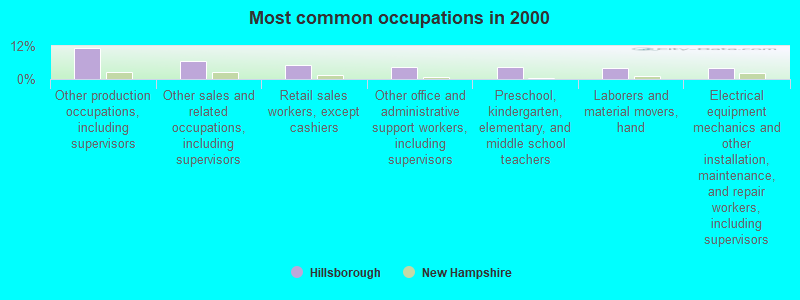
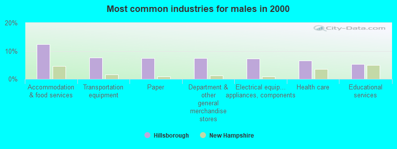
- Other production occupations, including supervisors (11.2%)
- Other sales and related occupations, including supervisors (6.4%)
- Retail sales workers, except cashiers (4.9%)
- Other office and administrative support workers, including supervisors (4.3%)
- Preschool, kindergarten, elementary, and middle school teachers (4.2%)
- Laborers and material movers, hand (4.1%)
- Electrical equipment mechanics and other installation, maintenance, and repair workers, including supervisors (4.0%)
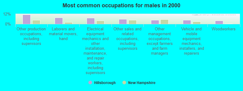
- Other production occupations, including supervisors (11.1%)
- Laborers and material movers, hand (7.6%)
- Electrical equipment mechanics and other installation, maintenance, and repair workers, including supervisors (7.4%)
- Other sales and related occupations, including supervisors (5.7%)
- Other management occupations, except farmers and farm managers (4.8%)
- Vehicle and mobile equipment mechanics, installers, and repairers (4.6%)
- Woodworkers (3.9%)
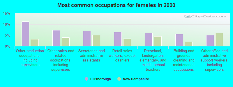
- Other production occupations, including supervisors (11.3%)
- Other sales and related occupations, including supervisors (7.3%)
- Secretaries and administrative assistants (7.1%)
- Retail sales workers, except cashiers (6.5%)
- Preschool, kindergarten, elementary, and middle school teachers (6.0%)
- Building and grounds cleaning and maintenance occupations (5.5%)
- Other office and administrative support workers, including supervisors (5.0%)
Average climate in Hillsborough, New Hampshire
Based on data reported by over 4,000 weather stations


(lower is better)
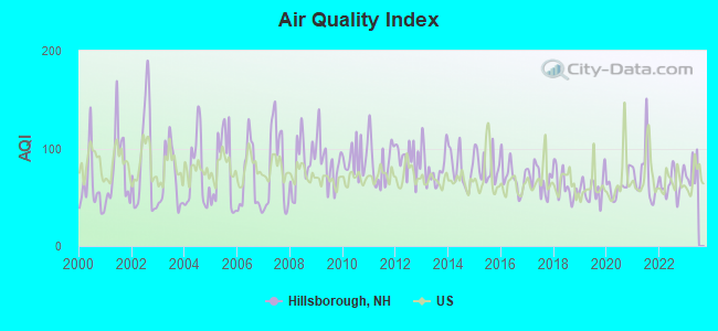
Air Quality Index (AQI) level in 2022 was 64.4. This is about average.
| City: | 64.4 |
| U.S.: | 72.6 |
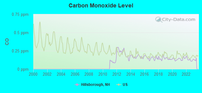
Carbon Monoxide (CO) [ppm] level in 2022 was 0.131. This is significantly better than average. Closest monitor was 14.6 miles away from the city center.
| City: | 0.131 |
| U.S.: | 0.251 |
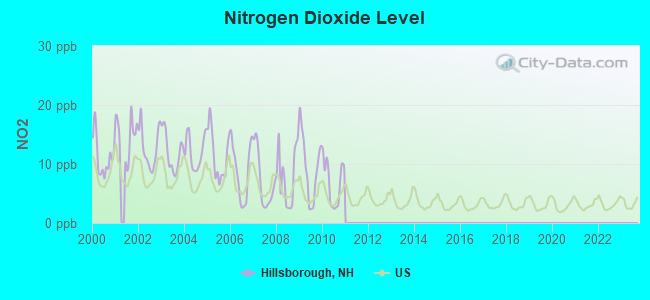
Nitrogen Dioxide (NO2) [ppb] level in 2010 was 6.85. This is worse than average. Closest monitor was 17.5 miles away from the city center.
| City: | 6.85 |
| U.S.: | 5.11 |
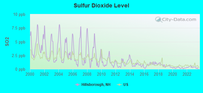
Sulfur Dioxide (SO2) [ppb] level in 2022 was 0.411. This is significantly better than average. Closest monitor was 14.6 miles away from the city center.
| City: | 0.411 |
| U.S.: | 1.515 |
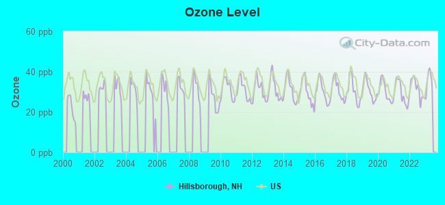
Ozone [ppb] level in 2022 was 31.5. This is about average. Closest monitor was 17.5 miles away from the city center.
| City: | 31.5 |
| U.S.: | 33.3 |
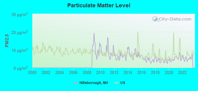
Particulate Matter (PM2.5) [µg/m3] level in 2022 was 4.85. This is significantly better than average. Closest monitor was 17.2 miles away from the city center.
| City: | 4.85 |
| U.S.: | 8.11 |
Tornado activity:
Hillsborough-area historical tornado activity is slightly above New Hampshire state average. It is 37% smaller than the overall U.S. average.
On 6/9/1953, a category F4 (max. wind speeds 207-260 mph) tornado 46.7 miles away from the Hillsborough place center killed 90 people and injured 1228 people and caused between $50,000,000 and $500,000,000 in damages.
On 5/31/1998, a category F2 (max. wind speeds 113-157 mph) tornado 6.5 miles away from the place center caused $30,000 in damages.
Earthquake activity:
Hillsborough-area historical earthquake activity is significantly above New Hampshire state average. It is 71% smaller than the overall U.S. average.On 4/20/2002 at 10:50:47, a magnitude 5.3 (5.3 ML, Depth: 3.0 mi, Class: Moderate, Intensity: VI - VII) earthquake occurred 132.0 miles away from Hillsborough center
On 10/7/1983 at 10:18:46, a magnitude 5.3 (5.1 MB, 5.3 LG, 5.1 ML) earthquake occurred 135.6 miles away from the city center
On 4/20/2002 at 10:50:47, a magnitude 5.2 (5.2 MB, 4.2 MS, 5.2 MW, 5.0 MW) earthquake occurred 131.4 miles away from the city center
On 1/19/1982 at 00:14:42, a magnitude 4.7 (4.5 MB, 4.7 MD, 4.5 LG, Class: Light, Intensity: IV - V) earthquake occurred 30.5 miles away from the city center
On 10/16/2012 at 23:12:25, a magnitude 4.7 (4.7 ML, Depth: 10.0 mi) earthquake occurred 70.7 miles away from Hillsborough center
On 10/2/1994 at 11:27:22, a magnitude 3.7 (3.5 LG, 3.7 LG, Depth: 6.2 mi, Class: Light, Intensity: II - III) earthquake occurred 56.6 miles away from Hillsborough center
Magnitude types: regional Lg-wave magnitude (LG), body-wave magnitude (MB), duration magnitude (MD), local magnitude (ML), surface-wave magnitude (MS), moment magnitude (MW)
Natural disasters:
The number of natural disasters in Hillsborough County (27) is a lot greater than the US average (15).Major Disasters (Presidential) Declared: 17
Emergencies Declared: 10
Causes of natural disasters: Storms: 13, Floods: 11, Winter Storms: 5, Snowstorms: 4, Hurricanes: 3, Snows: 3, Blizzard: 1, Ice Storm: 1, Snowfall: 1, Wind: 1 (Note: some incidents may be assigned to more than one category).
Colleges/universities with over 2000 students nearest to Hillsborough:
- NHTI-Concord's Community College (about 20 miles; Concord, NH; Full-time enrollment: 2,865)
- Saint Anselm College (about 22 miles; Manchester, NH; FT enrollment: 2,059)
- Southern New Hampshire University (about 23 miles; Manchester, NH; FT enrollment: 16,552)
- Keene State College (about 24 miles; Keene, NH; FT enrollment: 5,098)
- Mount Washington College (about 24 miles; Manchester, NH; FT enrollment: 2,187)
- Franklin Pierce University (about 25 miles; Rindge, NH; FT enrollment: 2,139)
- Mount Wachusett Community College (about 37 miles; Gardner, MA; FT enrollment: 3,143)
Public high school in Hillsborough:
- HILLSBORO-DEERING HIGH SCHOOL (Students: 496, Location: 12 HILLCAT DR., Grades: 9-12)
Public elementary/middle schools in Hillsborough:
- HILLSBORO-DEERING ELEMENTARY SCHOOL (Students: 596, Location: 4 HILLCAT DR., Grades: PK-5)
- HILLSBORO-DEERING MIDDLE SCHOOL (Students: 353, Location: 6 HILLCAT DR., Grades: 6-8)
Points of interest:
Notable locations in Hillsborough: Hillsboro Fire Department (A), Hillsborough Town Offices (B), Hillsboro Chamber of Commerce (C). Display/hide their locations on the map
Churches in Hillsborough include: Hillsboro United Methodist Church (A), Saint Marys Catholic Church (B). Display/hide their locations on the map
Cemetery: Preston Cemetery (1). Display/hide its location on the map
Tourist attraction: Fox State Forest (Recreation Areas; Center Road).
Birthplace of: Franklin Pierce - (1804-1869), President, Christopher Columbus Andrews - Union Army General, John Grimes Walker - Navy admiral, John McNeil Jr. - General, Wilson Bethel - Actor, David H. Goodell - Politician, John Sargent (1799–1880) - Politician.
Drinking water stations with addresses in Hillsborough and their reported violations in the past:
HILLSBOROUGH WATER WORKS (Population served: 2,000, Surface water):Past health violations:YOUNG RICHARDSON POST 59 (Population served: 25, Groundwater):Past monitoring violations:
- MCL, Average - Between JUL-2013 and SEP-2013, Contaminant: TTHM. Follow-up actions: St AO (w/o penalty) issued (OCT-12-2011), St Public Notif requested (OCT-18-2013), St Violation/Reminder Notice (OCT-18-2013), St Public Notif received (NOV-19-2013)
- MCL, Average - Between JUL-2013 and SEP-2013, Contaminant: Total Haloacetic Acids (HAA5). Follow-up actions: St AO (w/o penalty) issued (OCT-12-2011), St Public Notif requested (OCT-18-2013), St Violation/Reminder Notice (OCT-18-2013), St Public Notif received (NOV-19-2013)
- MCL, Average - Between APR-2013 and JUN-2013, Contaminant: TTHM. Follow-up actions: St AO (w/o penalty) issued (OCT-12-2011), St Public Notif requested (AUG-02-2013), St Violation/Reminder Notice (AUG-02-2013), St Public Notif received (SEP-04-2013)
- MCL, Average - Between APR-2013 and JUN-2013, Contaminant: Total Haloacetic Acids (HAA5). Follow-up actions: St AO (w/o penalty) issued (OCT-12-2011), St Public Notif requested (AUG-02-2013), St Violation/Reminder Notice (AUG-02-2013), St Public Notif received (SEP-04-2013)
- MCL, Average - Between JAN-2013 and MAR-2013, Contaminant: TTHM. Follow-up actions: St AO (w/o penalty) issued (OCT-12-2011), St Public Notif requested (MAY-10-2013), St Violation/Reminder Notice (MAY-10-2013), St Public Notif received (JUL-26-2013)
- MCL, Average - Between JAN-2013 and MAR-2013, Contaminant: Total Haloacetic Acids (HAA5). Follow-up actions: St AO (w/o penalty) issued (OCT-12-2011), St Public Notif requested (MAY-10-2013), St Violation/Reminder Notice (MAY-10-2013), St Public Notif received (JUL-26-2013)
- 57 other older health violations
- One minor monitoring violation
Past monitoring violations:
- Monitoring, Source Water (GWR) - Between JUL-19-2013 and AUG-19-2013, Contaminant: E. COLI. Follow-up actions: St Compliance achieved (AUG-13-2013), St Public Notif requested (AUG-21-2013), St Violation/Reminder Notice (AUG-21-2013), St Public Notif received (SEP-19-2013)
- Monitoring, Repeat Major (TCR) - Between JUL-2013 and SEP-2013, Contaminant: Coliform (TCR). Follow-up actions: St Compliance achieved (AUG-13-2013), St Public Notif requested (AUG-21-2013), St Violation/Reminder Notice (AUG-21-2013), St Public Notif received (SEP-19-2013)
| This place: | 2.4 people |
| New Hampshire: | 2.5 people |
| This place: | 59.8% |
| Whole state: | 66.3% |
| This place: | 10.4% |
| Whole state: | 8.3% |
Likely homosexual households (counted as self-reported same-sex unmarried-partner households)
- Lesbian couples: 0.5% of all households
- Gay men: 0.1% of all households
Banks with branches in Hillsborough (2011 data):
- Sovereign Bank, National Association: Valley Branch at 53 West Main Street, branch established on 1973/12/20. Info updated 2012/01/31: Bank assets: $78,146.9 mil, Deposits: $48,042.9 mil, headquarters in Wilmington, DE, positive income, Commercial Lending Specialization, 718 total offices, Holding Company: Banco Santander, S.A.
- Laconia Savings Bank: Hillsborough Branch at 325 West Main St, branch established on 1989/08/07. Info updated 2009/02/12: Bank assets: $1,107.3 mil, Deposits: $876.1 mil, headquarters in Laconia, NH, positive income, Commercial Lending Specialization, 23 total offices, Holding Company: Lsb Financial
- TD Bank, National Association: Hillsborough Branch at 11 School Street, branch established on 1968/11/01. Info updated 2010/10/04: Bank assets: $188,912.6 mil, Deposits: $153,149.8 mil, headquarters in Wilmington, DE, positive income, 1314 total offices, Holding Company: Toronto-Dominion Bank, The
For population 15 years and over in Hillsborough:
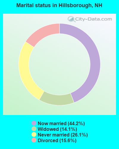
- Never married: 26.1%
- Now married: 44.2%
- Separated: 0.0%
- Widowed: 14.1%
- Divorced: 15.6%
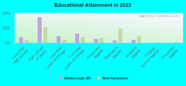
For population 25 years and over in Hillsborough:
- High school or higher: 90.4%
- Bachelor's degree or higher: 10.2%
- Graduate or professional degree: 5.2%
- Unemployed: 3.9%
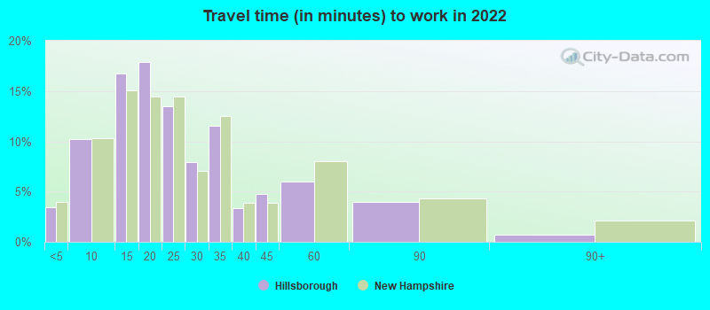
- Mean travel time to work (commute): 25.3 minutes
| Here: | 8.6 |
| New Hampshire average: | 10.3 |


Graphs represent county-level data. Detailed 2008 Election Results
Religion statistics for Hillsborough, NH (based on Hillsborough County data)


| Religion | Adherents | Congregations |
|---|---|---|
| Catholic | 124,993 | 40 |
| Evangelical Protestant | 20,588 | 103 |
| Mainline Protestant | 17,794 | 60 |
| Other | 7,365 | 35 |
| Orthodox | 2,990 | 7 |
| Black Protestant | - | 1 |
| None | 226,991 | - |
Food Environment Statistics:
| Hillsborough County: | 1.82 / 10,000 pop. |
| State: | 2.14 / 10,000 pop. |
| Here: | 0.12 / 10,000 pop. |
| New Hampshire: | 0.15 / 10,000 pop. |
| Hillsborough County: | 1.65 / 10,000 pop. |
| State: | 1.78 / 10,000 pop. |
| Hillsborough County: | 2.67 / 10,000 pop. |
| State: | 4.02 / 10,000 pop. |
| This county: | 8.23 / 10,000 pop. |
| State: | 9.70 / 10,000 pop. |
| Hillsborough County: | 6.9% |
| New Hampshire: | 7.6% |
| Here: | 24.5% |
| New Hampshire: | 24.4% |
| Hillsborough County: | 15.1% |
| New Hampshire: | 15.9% |
Health and Nutrition:
| Hillsborough: | 42.8% |
| New Hampshire: | 51.2% |
| This city: | 44.8% |
| New Hampshire: | 49.1% |
| Hillsborough: | 27.9 |
| New Hampshire: | 28.5 |
| This city: | 23.2% |
| State: | 20.9% |
| Hillsborough: | 6.7% |
| New Hampshire: | 9.3% |
| This city: | 6.8 |
| State: | 6.9 |
| Here: | 33.7% |
| New Hampshire: | 34.3% |
| Hillsborough: | 55.7% |
| State: | 58.1% |
| Here: | 81.4% |
| New Hampshire: | 79.1% |
More about Health and Nutrition of Hillsborough, NH Residents
6.73% of this county's 2021 resident taxpayers lived in other counties in 2020 ($92,767 average adjusted gross income)
| Here: | 6.73% |
| New Hampshire average: | 7.66% |
0.01% of residents moved from foreign countries ($183 average AGI)
Hillsborough County: 0.01% New Hampshire average: 0.01%
Top counties from which taxpayers relocated into this county between 2020 and 2021:
| from Middlesex County, MA | |
| from Rockingham County, NH | |
| from Merrimack County, NH |
6.49% of this county's 2020 resident taxpayers moved to other counties in 2021 ($81,100 average adjusted gross income)
| Here: | 6.49% |
| New Hampshire average: | 6.80% |
0.02% of residents moved to foreign countries ($105 average AGI)
Hillsborough County: 0.02% New Hampshire average: 0.01%
Top counties to which taxpayers relocated from this county between 2020 and 2021:
| to Rockingham County, NH | |
| to Merrimack County, NH | |
| to Middlesex County, MA |
| Businesses in Hillsborough, NH | ||||
| Name | Count | Name | Count | |
|---|---|---|---|---|
| Curves | 1 | Shaw's | 1 | |
| DHL | 1 | Subway | 1 | |
| McDonald's | 1 | UPS | 1 | |
Strongest AM radio stations in Hillsborough:
- WRKO (680 AM; 50 kW; BOSTON, MA; Owner: ENTERCOM BOSTON LICENSE, LLC)
- WNTK (1020 AM; 10 kW; NEWPORT, NH; Owner: KOOR COMMUNICATIONS, INC.)
- WCRN (830 AM; 50 kW; WORCESTER, MA; Owner: CARTER BROADCASTING CORPORATION)
- WGIR (610 AM; 5 kW; MANCHESTER, NH; Owner: CAPSTAR TX LIMITED PARTNERSHIP)
- WEEI (850 AM; 50 kW; BOSTON, MA; Owner: ENTERCOM BOSTON LICENSE, LLC)
- WNNZ (640 AM; 50 kW; WESTFIELD, MA; Owner: CLEAR CHANNEL BROADCASTING LICENSES, INC.)
- WKOX (1200 AM; 50 kW; FRAMINGHAM, MA; Owner: CAPSTAR TX LIMITED PARTNERSHIP)
- WBIX (1060 AM; 40 kW; NATICK, MA; Owner: LANGER BROADCASTING CORPORATION)
- WKBR (1250 AM; 5 kW; MANCHESTER, NH; Owner: DEVON BROADCASTING COMPANY, INC.)
- WWZN (1510 AM; 50 kW; BOSTON, MA; Owner: ROSE CITY RADIO CORPORATION)
- WVNE (760 AM; daytime; 25 kW; LEICESTER, MA; Owner: BLOUNT MASSCOM, INC.)
- WBZ (1030 AM; 50 kW; BOSTON, MA; Owner: INFINITY BROADCASTING OPERATIONS, INC.)
- WALE (990 AM; 50 kW; GREENVILLE, RI; Owner: NORTH AMERICAN BROADCASTING CO., INC.)
Strongest FM radio stations in Hillsborough:
- WTPL (107.7 FM; HILLSBORO, NH; Owner: CONCORD BROADCASTING, L.L.C.)
- WNNH (99.1 FM; HENNIKER, NH; Owner: TELE-MEDIA COMPANY OF NEW HAMPSHIRE, L.L.C.)
- WFEX (92.1 FM; PETERBOROUGH, NH; Owner: FNX BROADCASTING OF NEW HAMPSHIRE LLC)
- WHDQ (106.1 FM; CLAREMONT, NH; Owner: GREAT NORTHERN RADIO, L.L.C.)
- WGIR-FM (101.1 FM; MANCHESTER, NH; Owner: CAPSTAR TX LIMITED PARTNERSHIP)
- WQLL (96.5 FM; BEDFORD, NH; Owner: SAGA COMMUNICATIONS OF NEW ENGLAND, LLC)
- WLMW (90.7 FM; MANCHESTER, NH; Owner: KNOWLEDGE FOR LIFE)
- WZID (95.7 FM; MANCHESTER, NH; Owner: SAGA COMMUNICATIONS OF NEW ENGLAND, LLC)
- WVPR (89.5 FM; WINDSOR, VT; Owner: VERMONT PUBLIC RADIO)
- WKNE (103.7 FM; KEENE, NH; Owner: SAGA COMMUNICATIONS OF NEW ENGLAND, LLC)
- WEVN (90.7 FM; KEENE, NH; Owner: NEW HAMPSHIRE PUBLIC RADIO, INC.)
- WVRR (101.7 FM; NEWPORT, NH; Owner: CAPSTAR TX LIMITED PARTNERSHIP)
- WNHI (93.3 FM; BELMONT, NH; Owner: CONCORD BROADCASTING, L.L.C.)
- WJJR (98.1 FM; RUTLAND, VT; Owner: 6 JOHNSON ROAD LICENSES, INC.)
- WZRT (97.1 FM; RUTLAND, VT; Owner: CAPSTAR TX LIMITED PARTNERSHIP)
- WEBK (105.3 FM; KILLINGTON, VT; Owner: 6 JOHNSON ROAD LICENSES, INC.)
- WPKQ (103.7 FM; NORTH CONWAY, NH; Owner: CITADEL BROADCASTING COMPANY)
- WSCY (106.9 FM; MOULTONBOROUGH, NH; Owner: NORTHEAST COMMUNICATIONS CORPORATION)
- WNTK-FM (99.7 FM; NEW LONDON, NH; Owner: SHEILA E. VINIKOOR)
- WEQX (102.7 FM; MANCHESTER, VT; Owner: NORTHSHIRE COMMUNICATIONS, INC.)
TV broadcast stations around Hillsborough:
- WEKW-TV (Channel 52; KEENE, NH; Owner: UNIVERSITY OF NEW HAMPSHIRE)
- WMUR-TV (Channel 9; MANCHESTER, NH; Owner: HEARST-ARGYLE PROPERTIES, INC.)
Hillsborough fatal accident list:
- National Bridge Inventory (NBI) Statistics
- 29Number of bridges
- 230ft / 69.7mTotal length
- $69,124,000Total costs
- 92,691Total average daily traffic
- 6,437Total average daily truck traffic
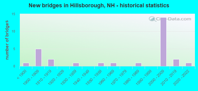
- New bridges - historical statistics
- 1Before 1900
- 51900-1909
- 21910-1919
- 11930-1939
- 11950-1959
- 11960-1969
- 11980-1989
- 142000-2009
- 22010-2019
- 12020-2022
FCC Registered Antenna Towers:
8 (See the full list of FCC Registered Antenna Towers in Hillsborough)FCC Registered Broadcast Land Mobile Towers:
3- Lat: 43.116806 Lon: -71.902083, Call Sign: WQQB572,
Assigned Frequencies: 151.565 MHz, 152.990 MHz, 160.207 MHz, Grant Date: 07/19/2022, Expiration Date: 10/16/2032, Certifier: Glen Woods, Registrant: Business Radio Licensing, 30251 Golden Lantern, Suite E #501, Laguna Niguel, CA 92677, Phone: (949) 348-8510, Fax: (949) 348-8514, Email:
- JACKMAN HYDRO DAM, 50 Dam Road (Lat: 43.110694 Lon: -71.948667), Type: Building, Structure height: 1.5 m, Overall height: 6.1 m, Call Sign: WQZR250,
Assigned Frequencies: 153.245 MHz, Grant Date: 07/13/2017, Expiration Date: 07/13/2027, Certifier: Matt Acton, Registrant: Keller And Heckman LLP, 1001 G Street, Nw, Suite 500 West, Washington, DC 20001, Phone: (202) 434-4100, Fax: (202) 434-4646, Email:
- Lat: 43.114500 Lon: -71.905972, Call Sign: WRTN995,
Assigned Frequencies: 159.540 MHz, 160.065 MHz, Grant Date: 07/09/2022, Expiration Date: 07/09/2032, Certifier: Luke C Levesque, Registrant: Washington Radio Reports, Gettysburg, PA 17325, Phone: (717) 334-0668, Fax: (717) 334-6440, Email:
FCC Registered Amateur Radio Licenses:
17 (See the full list of FCC Registered Amateur Radio Licenses in Hillsborough)FAA Registered Aircraft:
2- Aircraft: PIPER PA-28-151 (Category: Land, Seats: 4, Weight: Up to 12,499 Pounds, Speed: 80 mph), Engine: LYCOMING 0-320 SERIES (180 HP) (Reciprocating)
N-Number: 6132J, N6132J, N-6132J, Serial Number: 28-7615309, Year manufactured: 1976, Airworthiness Date: 05/24/1976, Certificate Issue Date: 05/18/2006
Registrant (Individual): Gary Harvey, Po Box 1112, Hillsborough, NH 03244 - Aircraft: BALLOON WORKS FIREFLY 7 (Category: Land, Weight: Up to 12,499 Pounds, Speed: 63 mph), Engine: None
N-Number: 2075F, N2075F, N-2075F, Serial Number: F7-727, Year manufactured: 1976, Airworthiness Date: 03/23/1985, Certificate Issue Date: 05/15/1985
Registrant (Individual): George A Belanger, Po Box 15, Hillsborough, NH 03244
Deregistered: Cancel Date: 04/04/2017
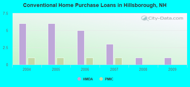
| Home Mortgage Disclosure Act Aggregated Statistics For Year 2009 (Based on 1 partial tract) | ||||||
| A) FHA, FSA/RHS & VA Home Purchase Loans | B) Conventional Home Purchase Loans | C) Refinancings | ||||
|---|---|---|---|---|---|---|
| Number | Average Value | Number | Average Value | Number | Average Value | |
| LOANS ORIGINATED | 1 | $133,090 | 1 | $79,470 | 4 | $146,665 |
| APPLICATIONS APPROVED, NOT ACCEPTED | 0 | $0 | 0 | $0 | 0 | $0 |
| APPLICATIONS DENIED | 0 | $0 | 0 | $0 | 2 | $178,965 |
| APPLICATIONS WITHDRAWN | 0 | $0 | 0 | $0 | 1 | $114,210 |
| FILES CLOSED FOR INCOMPLETENESS | 0 | $0 | 0 | $0 | 0 | $0 |
Detailed HMDA statistics for the following Tracts: 0255.00
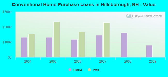
| Private Mortgage Insurance Companies Aggregated Statistics For Year 2007 (Based on 1 partial tract) | ||
| A) Conventional Home Purchase Loans | ||
|---|---|---|
| Number | Average Value | |
| LOANS ORIGINATED | 1 | $230,740 |
| APPLICATIONS APPROVED, NOT ACCEPTED | 0 | $0 |
| APPLICATIONS DENIED | 0 | $0 |
| APPLICATIONS WITHDRAWN | 0 | $0 |
| FILES CLOSED FOR INCOMPLETENESS | 0 | $0 |
Detailed PMIC statistics for the following Tracts: 0255.00
2008 - 2018 National Fire Incident Reporting System (NFIRS) incidents
- Fire incident types reported to NFIRS in Hillsborough, NH
- 5656.0%Structure Fires
- 2525.0%Outside Fires
- 1717.0%Mobile Property/Vehicle Fires
- 22.0%Other
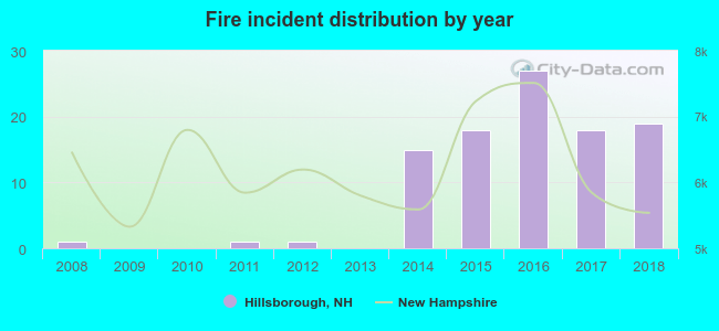 According to the data from the years 2008 - 2018 the average number of fire incidents per year is 9. The highest number of reported fires - 27 took place in 2016, and the least - 0 in 2009. The data has a growing trend.
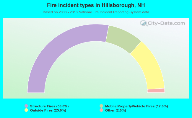 When looking into fire subcategories, the most reports belonged to: Structure Fires (56.0%), and Outside Fires (25.0%).
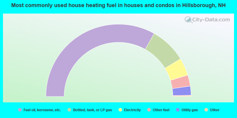
- 66.7%Fuel oil, kerosene, etc.
- 16.3%Bottled, tank, or LP gas
- 7.9%Electricity
- 5.0%Other fuel
- 4.1%Utility gas
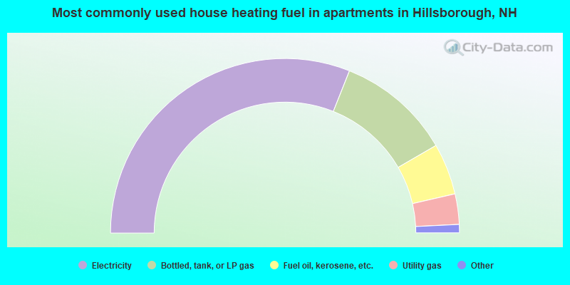
- 63.1%Electricity
- 21.6%Bottled, tank, or LP gas
- 9.7%Fuel oil, kerosene, etc.
- 5.7%Utility gas
Hillsborough compared to New Hampshire state average:
- Median house value below state average.
- Unemployed percentage significantly below state average.
- Black race population percentage significantly below state average.
- Median age significantly below state average.
- Foreign-born population percentage significantly below state average.
- Renting percentage above state average.
- House age above state average.
- Percentage of population with a bachelor's degree or higher significantly below state average.

|
|
Total of 20 patent applications in 2008-2024.