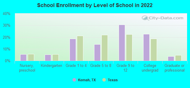
Kemah, Texas
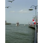
Kemah: Another view of the Boardwalk and bay
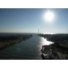
Kemah: Taken on 10-29-05 from Kemah bridge looking out to Galveston Bay. Konica-Minolta A200

Kemah: Wildlife on the bay
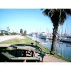
Kemah: View of Bay from deck of nearby rental
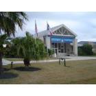
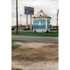
Kemah: Kemah TX, City Hall
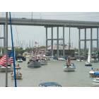
Kemah: Kemah Annual Blessing of the Fleet!
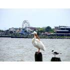
Kemah: White Pelican looking at Seagull with Kemah Boardwalk in background
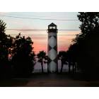
Kemah: Sunrise at Kemah Lighthouse
Kemah: kemah, tx: water tower next to highway 146

Kemah: Light house at Kemah, Texas
Kemah: boardwalk: kemah, tx (galveston county)
- see
21
more - add
your
Submit your own pictures of this city and show them to the world
- OSM Map
- General Map
- Google Map
- MSN Map

Population change since 2000: -23.1%
| Males: 912 | |
| Females: 880 |
| Median resident age: | 42.3 years |
| Texas median age: | 35.6 years |
Zip codes: 77565.
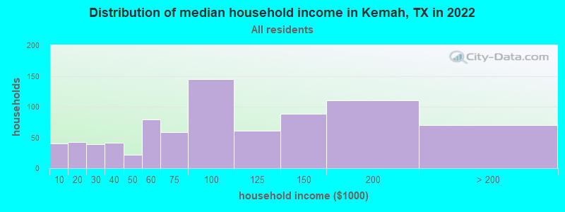
| Kemah: | $83,767 |
| TX: | $72,284 |
Estimated per capita income in 2022: $40,387 (it was $23,373 in 2000)
Kemah city income, earnings, and wages data
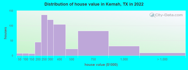
Estimated median house or condo value in 2022: $306,375 (it was $124,300 in 2000)
| Kemah: | $306,375 |
| TX: | $275,400 |
Mean prices in 2022: all housing units: $342,034; detached houses: $355,202; townhouses or other attached units: $346,206; in 2-unit structures: $245,035; in 3-to-4-unit structures: $196,054; in 5-or-more-unit structures: $344,163; mobile homes: $79,525; occupied boats, rvs, vans, etc.: $47,721
Median gross rent in 2022: $1,738.
(5.2% for White Non-Hispanic residents, 27.7% for Black residents, 48.0% for Hispanic or Latino residents, 57.0% for other race residents, 24.3% for two or more races residents)
Detailed information about poverty and poor residents in Kemah, TX


Compare current foreclosures near Kemah, TX:
| Photo | Address | Area | Beds / Baths | Price | Details |
|---|---|---|---|---|---|

|
#1
Bay Oaks Dr
Kemah, TX 77565
|
1,972 sq. feet
|
2 baths 3 beds |
show details | |

|
#2
Esther St
Kemah, TX 77565
|
1,332 sq. feet
|
2 baths 3 beds |
show details | |

|
#3
E Shore Dr
Kemah, TX 77565
|
1,042 sq. feet
|
2 baths - beds |
show details | |

|
#4
Elm Rd
Kemah, TX 77565
|
- sq. feet
|
- baths - beds |
show details | |

|
#5
11th St N
Texas City, TX 77590
|
2,625 sq. feet
|
3 baths 4 beds |
$449,900
|
show details |

|
#6
Stonefair Ln
Houston, TX 77075
|
2,594 sq. feet
|
3 baths 4 beds |
$305,000
|
show details |

|
#7
Creekview Dr
La Porte, TX 77571
|
2,986 sq. feet
|
2 baths 3 beds |
$199,500
|
show details |

|
#8
32nd Ave N
Texas City, TX 77591
|
1,520 sq. feet
|
2 baths 3 beds |
show details | |

|
#9
Robinwood Dr
Deer Park, TX 77536
|
2,621 sq. feet
|
2 baths 3 beds |
show details | |

|
#10
Wessex Dr
Houston, TX 77089
|
1,769 sq. feet
|
2 baths 3 beds |
show details |
| Photo | Address | Area | Beds / Baths | Price | Details |
|---|---|---|---|---|---|

|
#11
Diamond Oak Dr
Texas City, TX 77591
|
3,031 sq. feet
|
2 baths 5 beds |
show details | |

|
#12
Oleander Ave
Texas City, TX 77590
|
- sq. feet
|
2 baths 3 beds |
show details | |

|
#13
Shady Oaks Ln
Friendswood, TX 77546
|
1,873 sq. feet
|
2 baths 3 beds |
show details | |

|
#14
Ruby Dr
Texas City, TX 77591
|
- sq. feet
|
2 baths 4 beds |
show details | |

|
#15
Wildfire St
League City, TX 77573
|
1,375 sq. feet
|
2 baths 3 beds |
show details | |

|
#16
Carlow Ln
La Porte, TX 77571
|
1,668 sq. feet
|
2 baths 3 beds |
show details | |

|
#17
Fm 646 Rd N
Dickinson, TX 77539
|
- sq. feet
|
3 baths 4 beds |
show details | |

|
#18
34th Ave N
Texas City, TX 77591
|
- sq. feet
|
3 baths 4 beds |
show details | |

|
#19
16th Ave N
Texas City, TX 77590
|
1,905 sq. feet
|
2 baths 4 beds |
show details | |

|
#20
Pilgrims Point Dr
Webster, TX 77598
|
1,708 sq. feet
|
2 baths 3 beds |
show details |
| Photo | Address | Area | Beds / Baths | Price | Details |
|---|---|---|---|---|---|

|
#21
Silver Landing Ln
Dickinson, TX 77539
|
- sq. feet
|
2 baths 3 beds |
show details | |

|
#22
Mammoth Springs Ln
Dickinson, TX 77539
|
1,915 sq. feet
|
2 baths 3 beds |
show details | |

|
#23
Shannon Ridge Rd
Houston, TX 77062
|
2,024 sq. feet
|
2 baths 3 beds |
show details | |

|
#24
Chestnut Springs Ln
Houston, TX 77062
|
2,127 sq. feet
|
2 baths 4 beds |
show details | |

|
#25
Peermont St
Houston, TX 77062
|
2,304 sq. feet
|
2 baths 4 beds |
show details | |

|
#26
Edwards Dr
Dickinson, TX 77539
|
1,424 sq. feet
|
3 baths 4 beds |
show details | |

|
#27
Brook Forest Dr
Houston, TX 77059
|
4,040 sq. feet
|
3 baths 3 beds |
show details | |

|
#28
Cambria Ct
League City, TX 77573
|
3,251 sq. feet
|
3 baths 4 beds |
show details | |

|
#29
N Shady Ln
La Porte, TX 77571
|
1,787 sq. feet
|
2 baths 3 beds |
show details | |

|
#30
Regency Dr
Deer Park, TX 77536
|
2,500 sq. feet
|
2 baths 5 beds |
show details |
| Photo | Address | Area | Beds / Baths | Price | Details |
|---|---|---|---|---|---|

|
#31
Santa Fe Trl
Santa Fe, TX 77510
|
1,356 sq. feet
|
2 baths 3 beds |
show details | |

|
#32
Fairdale St
Pasadena, TX 77505
|
1,952 sq. feet
|
2 baths 3 beds |
show details | |

|
#33
Sagecanyon Dr
Houston, TX 77089
|
- sq. feet
|
2 baths 3 beds |
show details | |

|
#34
Mclean Rd
Pearland, TX 77584
|
1,956 sq. feet
|
2 baths 3 beds |
show details | |

|
#35
Hemlock Dr
Pasadena, TX 77502
|
1,498 sq. feet
|
2 baths 3 beds |
show details | |

|
#36
Tallow Cove Dr
Baytown, TX 77521
|
2,009 sq. feet
|
2 baths 3 beds |
show details | |

|
#37
Burnett Dr
Baytown, TX 77520
|
2,520 sq. feet
|
2 baths 4 beds |
show details | |

|
#38
Canadian Goose Ln
Baytown, TX 77521
|
- sq. feet
|
2 baths 4 beds |
show details | |

|
#39
Mossy Hollow Ln
Houston, TX 77075
|
1,957 sq. feet
|
2 baths 3 beds |
show details | |

|
#40
Texas Sage Dr
Houston, TX 77075
|
- sq. feet
|
2 baths 4 beds |
show details |
| Photo | Address | Area | Beds / Baths | Price | Details |
|---|---|---|---|---|---|

|
#41
Kittrell St
Houston, TX 77034
|
1,380 sq. feet
|
1 baths 3 beds |
show details | |

|
#42
Blimp Base Road
Hitchcock, TX 77563
|
- sq. feet
|
2 baths 4 beds |
show details | |

|
#43
Valley Tree Ln
Houston, TX 77089
|
- sq. feet
|
2 baths 3 beds |
show details | |

|
#44
Prairie Ave
Pasadena, TX 77506
|
1,978 sq. feet
|
2 baths 3 beds |
show details | |

|
#45
Stoneridge Canyon Ct
Houston, TX 77089
|
1,490 sq. feet
|
1 baths 3 beds |
show details | |

|
#46
Ella Ct
Friendswood, TX 77546
|
1,323 sq. feet
|
1 baths 3 beds |
show details | |

|
#47
Chia Valley Ct
Houston, TX 77089
|
2,169 sq. feet
|
2 baths 3 beds |
show details | |

|
#48
Coronation Dr
Houston, TX 77034
|
4,058 sq. feet
|
3 baths 3 beds |
show details | |

|
#49
Sageberry Dr
Houston, TX 77089
|
1,956 sq. feet
|
2 baths 3 beds |
show details | |

|
Check over 1 million property listings on Foreclosure.com!
|
browse all offers | |||


- 1,07354.2%White alone
- 57729.1%Hispanic
- 1507.6%Black alone
- 824.1%Asian alone
- 633.2%Two or more races
- 552.8%Other race alone
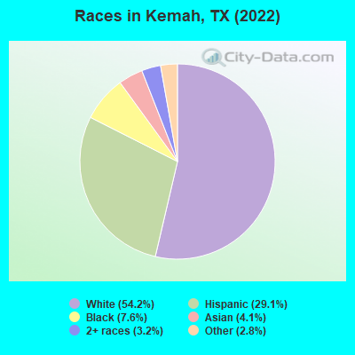
Races in Kemah detailed stats: ancestries, foreign born residents, place of birth
According to our research of Texas and other state lists, there were 4 registered sex offenders living in Kemah, Texas as of April 27, 2024.
The ratio of all residents to sex offenders in Kemah is 549 to 1.
The ratio of registered sex offenders to all residents in this city is lower than the state average.
Type |
2009 |
2010 |
2011 |
2012 |
2013 |
2014 |
2015 |
2016 |
2017 |
2018 |
2019 |
2020 |
2021 |
2022 |
|---|---|---|---|---|---|---|---|---|---|---|---|---|---|---|
| Murders (per 100,000) | 0 (0.0) | 0 (0.0) | 0 (0.0) | 0 (0.0) | 0 (0.0) | 0 (0.0) | 0 (0.0) | 0 (0.0) | 0 (0.0) | 0 (0.0) | 1 (48.6) | 0 (0.0) | 0 (0.0) | 0 (0.0) |
| Rapes (per 100,000) | 0 (0.0) | 3 (169.2) | 0 (0.0) | 1 (54.7) | 0 (0.0) | 1 (50.9) | 1 (49.8) | 1 (49.3) | 0 (0.0) | 2 (97.1) | 2 (97.3) | 3 (146.6) | 1 (48.2) | 2 (111.5) |
| Robberies (per 100,000) | 5 (198.6) | 5 (282.0) | 4 (221.0) | 3 (164.2) | 6 (313.8) | 4 (203.7) | 5 (249.0) | 4 (197.2) | 6 (294.6) | 1 (48.5) | 3 (145.9) | 0 (0.0) | 1 (48.2) | 2 (111.5) |
| Assaults (per 100,000) | 1 (39.7) | 3 (169.2) | 7 (386.7) | 3 (164.2) | 3 (156.9) | 8 (407.3) | 1 (49.8) | 2 (98.6) | 1 (49.1) | 2 (97.1) | 2 (97.3) | 5 (244.4) | 6 (289.0) | 4 (223.0) |
| Burglaries (per 100,000) | 4 (158.9) | 7 (394.8) | 22 (1,215) | 38 (2,080) | 13 (679.9) | 13 (661.9) | 11 (547.8) | 11 (542.4) | 8 (392.7) | 15 (728.2) | 5 (243.2) | 11 (537.6) | 12 (578.0) | 8 (445.9) |
| Thefts (per 100,000) | 88 (3,495) | 127 (7,163) | 80 (4,420) | 157 (8,593) | 138 (7,218) | 237 (12,067) | 156 (7,769) | 141 (6,953) | 143 (7,020) | 109 (5,291) | 83 (4,037) | 76 (3,715) | 71 (3,420) | 61 (3,400) |
| Auto thefts (per 100,000) | 6 (238.3) | 6 (338.4) | 3 (165.7) | 2 (109.5) | 4 (209.2) | 2 (101.8) | 3 (149.4) | 7 (345.2) | 6 (294.6) | 15 (728.2) | 8 (389.1) | 6 (293.3) | 7 (337.2) | 7 (390.2) |
| Arson (per 100,000) | 0 (0.0) | 0 (0.0) | 0 (0.0) | 0 (0.0) | 0 (0.0) | 0 (0.0) | 0 (0.0) | 0 (0.0) | 0 (0.0) | 0 (0.0) | 0 (0.0) | 0 (0.0) | 1 (48.2) | 0 (0.0) |
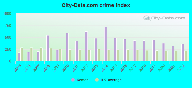
| City-Data.com crime index | 237.5 | 595.0 | 418.8 | 624.0 | 478.6 | 720.5 | 485.6 | 462.0 | 430.0 | 432.5 | 448.0 | 375.9 | 315.0 | 365.7 |
The City-Data.com crime index weighs serious crimes and violent crimes more heavily. Higher means more crime, U.S. average is 246.1. It adjusts for the number of visitors and daily workers commuting into cities.
Crime rate in Kemah detailed stats: murders, rapes, robberies, assaults, burglaries, thefts, arson
Full-time law enforcement employees in 2021, including police officers: 28 (21 officers - 17 male; 4 female).
| Officers per 1,000 residents here: | 10.12 |
| Texas average: | 2.07 |
 Recent articles from our blog. Our writers, many of them Ph.D. graduates or candidates, create easy-to-read articles on a wide variety of topics.

 | Houston CORE developments thread (707 replies) |
| Why is Dallas so underrated for nightlife? (114 replies) |
| Houston vs Dallas for my next Texas trip (108 replies) |
| Questions for a Short Weekend Visit (108 replies) |
| Pollen counts- Houston vs Kemah (9 replies) |
| Any other places similar to Kemah boardwalk close to Houston? (8 replies) |
Latest news from Kemah, TX collected exclusively by city-data.com from local newspapers, TV, and radio stations
Ancestries: German (8.0%), European (5.8%), Italian (4.7%), Irish (4.6%), American (3.8%), British (2.4%).
Current Local Time: CST time zone
Elevation: 12 feet
Land area: 1.79 square miles.
Population density: 1,000 people per square mile (low).
241 residents are foreign born (8.3% Latin America, 1.7% Asia, 1.3% Europe).
| This city: | 12.2% |
| Texas: | 17.1% |
Median real estate property taxes paid for housing units with mortgages in 2022: $3,892 (1.3%)
Median real estate property taxes paid for housing units with no mortgage in 2022: $5,098 (1.2%)
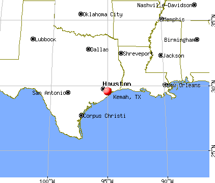
Nearest city with pop. 50,000+: Southeast Harris, TX (8.3 miles  , pop. 82,015).
Nearest city with pop. 200,000+: Houston, TX (26.8 miles , pop. 1,953,631).
Nearest cities:
), Latitude: 29.54 N, Longitude: 95.02 W
Area codes: 281, 832
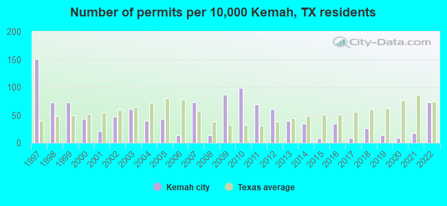
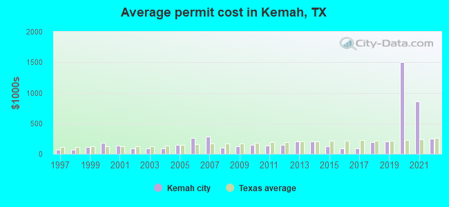
Single-family new house construction building permits:
- 2022: 17 buildings, average cost: $244,900
- 2021: 4 buildings, average cost: $854,800
- 2020: 2 buildings, average cost: $1,502,500
- 2019: 3 buildings, average cost: $201,600
- 2018: 6 buildings, average cost: $196,300
- 2017: 2 buildings, average cost: $92,300
- 2016: 8 buildings, average cost: $92,300
- 2015: 2 buildings, average cost: $122,000
- 2014: 8 buildings, average cost: $200,000
- 2013: 9 buildings, average cost: $200,000
- 2012: 14 buildings, average cost: $149,800
- 2011: 16 buildings, average cost: $136,300
- 2010: 23 buildings, average cost: $144,800
- 2009: 20 buildings, average cost: $127,400
- 2008: 3 buildings, average cost: $106,700
- 2007: 17 buildings, average cost: $276,600
- 2006: 3 buildings, average cost: $255,300
- 2005: 10 buildings, average cost: $151,600
- 2004: 9 buildings, average cost: $91,900
- 2003: 14 buildings, average cost: $94,800
- 2002: 11 buildings, average cost: $87,200
- 2001: 5 buildings, average cost: $133,900
- 2000: 10 buildings, average cost: $179,300
- 1999: 17 buildings, average cost: $110,900
- 1998: 17 buildings, average cost: $63,800
- 1997: 35 buildings, average cost: $71,700
| Here: | 3.9% |
| Texas: | 3.5% |
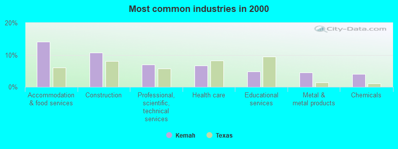
- Accommodation & food services (14.1%)
- Construction (10.7%)
- Professional, scientific, technical services (7.0%)
- Health care (6.7%)
- Educational services (4.7%)
- Metal & metal products (4.5%)
- Chemicals (4.1%)
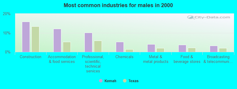
- Construction (15.7%)
- Accommodation & food services (12.2%)
- Professional, scientific, technical services (10.1%)
- Chemicals (5.2%)
- Metal & metal products (4.0%)
- Food & beverage stores (3.7%)
- Broadcasting & telecommunications (3.3%)
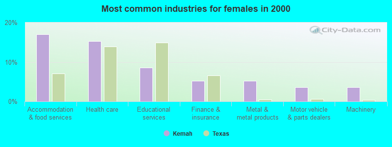
- Accommodation & food services (17.0%)
- Health care (15.2%)
- Educational services (8.6%)
- Finance & insurance (5.2%)
- Metal & metal products (5.2%)
- Motor vehicle & parts dealers (3.6%)
- Machinery (3.6%)
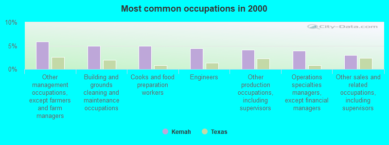
- Other management occupations, except farmers and farm managers (5.9%)
- Building and grounds cleaning and maintenance occupations (5.0%)
- Cooks and food preparation workers (4.9%)
- Engineers (4.4%)
- Other production occupations, including supervisors (4.2%)
- Operations specialties managers, except financial managers (3.9%)
- Other sales and related occupations, including supervisors (2.9%)
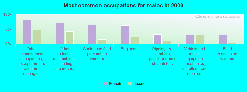
- Other management occupations, except farmers and farm managers (8.1%)
- Other production occupations, including supervisors (7.0%)
- Cooks and food preparation workers (6.4%)
- Engineers (6.2%)
- Pipelayers, plumbers, pipefitters, and steamfitters (3.2%)
- Vehicle and mobile equipment mechanics, installers, and repairers (3.0%)
- Food processing workers (3.0%)
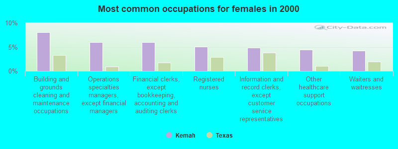
- Building and grounds cleaning and maintenance occupations (8.0%)
- Operations specialties managers, except financial managers (6.0%)
- Financial clerks, except bookkeeping, accounting and auditing clerks (6.0%)
- Registered nurses (5.0%)
- Information and record clerks, except customer service representatives (4.8%)
- Other healthcare support occupations (4.4%)
- Waiters and waitresses (4.2%)
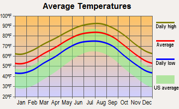
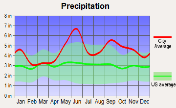
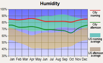
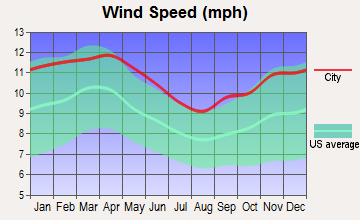
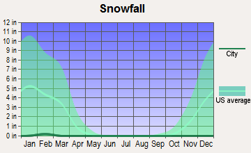
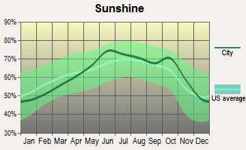
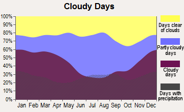
Average climate in Kemah, Texas
Based on data reported by over 4,000 weather stations
|
|


(lower is better)
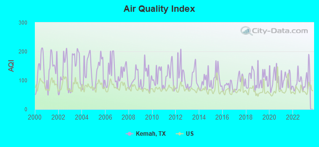
Air Quality Index (AQI) level in 2022 was 89.9. This is worse than average.
| City: | 89.9 |
| U.S.: | 72.6 |
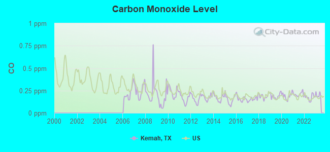
Carbon Monoxide (CO) [ppm] level in 2022 was 0.177. This is significantly better than average. Closest monitor was 2.3 miles away from the city center.
| City: | 0.177 |
| U.S.: | 0.251 |
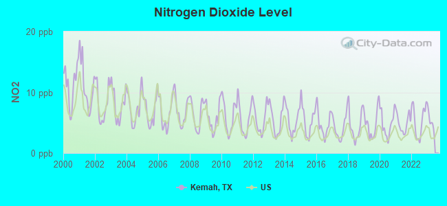
Nitrogen Dioxide (NO2) [ppb] level in 2022 was 5.35. This is about average. Closest monitor was 2.3 miles away from the city center.
| City: | 5.35 |
| U.S.: | 5.11 |
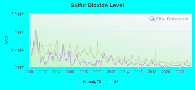
Sulfur Dioxide (SO2) [ppb] level in 2022 was 0.263. This is significantly better than average. Closest monitor was 2.3 miles away from the city center.
| City: | 0.263 |
| U.S.: | 1.515 |
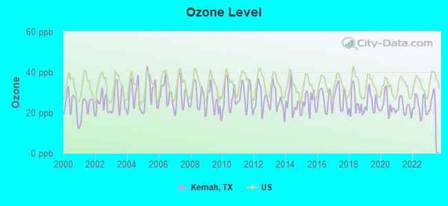
Ozone [ppb] level in 2022 was 23.2. This is significantly better than average. Closest monitor was 2.3 miles away from the city center.
| City: | 23.2 |
| U.S.: | 33.3 |
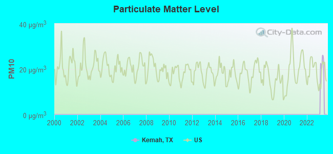
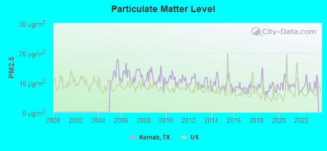
Particulate Matter (PM2.5) [µg/m3] level in 2022 was 8.65. This is about average. Closest monitor was 3.0 miles away from the city center.
| City: | 8.65 |
| U.S.: | 8.11 |
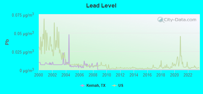
Lead (Pb) [µg/m3] level in 2008 was 0.00590. This is significantly better than average. Closest monitor was 0.6 miles away from the city center.
| City: | 0.00590 |
| U.S.: | 0.00931 |
Tornado activity:
Kemah-area historical tornado activity is slightly above Texas state average. It is 74% greater than the overall U.S. average.
On 11/21/1992, a category F4 (max. wind speeds 207-260 mph) tornado 20.5 miles away from the Kemah city center injured 16 people and caused between $50,000,000 and $500,000,000 in damages.
On 9/12/1961, a category F4 tornado 20.9 miles away from the city center killed 8 people and injured 200 people.
Earthquake activity:
Kemah-area historical earthquake activity is significantly above Texas state average. It is 41% smaller than the overall U.S. average.On 5/17/2012 at 08:12:00, a magnitude 4.8 (4.8 MW, Depth: 3.1 mi, Class: Light, Intensity: IV - V) earthquake occurred 169.5 miles away from Kemah center
On 10/20/2011 at 12:24:41, a magnitude 4.8 (4.8 MW, Depth: 3.1 mi) earthquake occurred 190.5 miles away from Kemah center
On 9/2/2013 at 23:51:15, a magnitude 4.3 (4.3 MW, Depth: 2.9 mi) earthquake occurred 167.7 miles away from Kemah center
On 9/2/2013 at 21:52:38, a magnitude 4.2 (4.2 MW, Depth: 3.0 mi) earthquake occurred 170.3 miles away from the city center
On 4/9/1993 at 12:29:19, a magnitude 4.3 (4.1 MB, 4.3 LG, Depth: 3.1 mi) earthquake occurred 194.2 miles away from the city center
On 1/25/2013 at 07:01:19, a magnitude 4.1 (4.1 MB, Depth: 3.1 mi) earthquake occurred 165.0 miles away from the city center
Magnitude types: regional Lg-wave magnitude (LG), body-wave magnitude (MB), moment magnitude (MW)
Natural disasters:
The number of natural disasters in Galveston County (23) is greater than the US average (15).Major Disasters (Presidential) Declared: 14
Emergencies Declared: 7
Causes of natural disasters: Hurricanes: 11, Storms: 7, Floods: 6, Fires: 2, Tornadoes: 2, Tropical Storms: 2, Flash Flood: 1, Wind: 1, Other: 1 (Note: some incidents may be assigned to more than one category).

Hospitals and medical centers near Kemah:
- CITY CROWN HOME HEALTH AGENCY INC (Home Health Center, about 1 miles away; FRIENDSWOOD, TX)
- A AND G HOME HEALTH SERVICES (Home Health Center, about 1 miles away; SEABROOK, TX)
- A AND G PERSONAL PROVIDER SERVICES (Home Health Center, about 1 miles away; SEABROOK, TX)
- HARBOURVIEW CARE CENTER (Nursing Home, about 3 miles away; LEAGUE CITY, TX)
- BAYWIND VILLAGE CONVALESCENT CENTER (Nursing Home, about 5 miles away; LEAGUE CITY, TX)
- BAYWIND VILLAGE CONVALESCENT CTR (Nursing Home, about 5 miles away; LEAGUE CITY, TX)
- CHRISTUS HOMECARE ST JOHN (Home Health Center, about 5 miles away; NASSAU BAY, TX)
Colleges/universities with over 2000 students nearest to Kemah:
- University of Houston-Clear Lake (about 6 miles; Houston, TX; Full-time enrollment: 5,833)
- College of the Mainland (about 11 miles; Texas City, TX; FT enrollment: 2,739)
- San Jacinto Community College (about 11 miles; Pasadena, TX; FT enrollment: 13,517)
- Lee College (about 14 miles; Baytown, TX; FT enrollment: 4,278)
- Alvin Community College (about 17 miles; Alvin, TX; FT enrollment: 3,953)
- The University of Texas Medical Branch (about 22 miles; Galveston, TX; FT enrollment: 2,314)
- University of Houston (about 24 miles; Houston, TX; FT enrollment: 31,888)
Public elementary/middle school in Kemah:
- LAVACE STEWART EL (Students: 557, Location: 330 HWY 2094, Grades: PK-5)
Points of interest:
Notable locations in Kemah: Lafayette Landing Marina (A), Kemah Volunteer Fire Department (B), Kemah Police Department (C). Display/hide their locations on the map
Tourist attraction: Adventure Travel (Recreational Trips & Guides; 2353 Windy Cove Court).
Hotel: Comfort Inn & Suites (2901 North A S A Road 1).
Drinking water stations with addresses in Kemah and their reported violations in the past:
HARBOR SEAFOOD INC (Population served: 25, Groundwater):Past monitoring violations:
- 4 routine major monitoring violations
- One minor monitoring violation
| This city: | 2.8 people |
| Texas: | 2.8 people |
| This city: | 73.4% |
| Whole state: | 69.9% |
| This city: | 5.4% |
| Whole state: | 6.0% |
Likely homosexual households (counted as self-reported same-sex unmarried-partner households)
- Lesbian couples: 0.5% of all households
- Gay men: 0.5% of all households
Banks with branches in Kemah (2011 data):
- Texas First Bank: Kemah Branch at 1100 Highway 146, branch established on 1995/10/10. Info updated 2011/05/16: Bank assets: $692.5 mil, Deposits: $616.8 mil, headquarters in Texas City, TX, positive income, Commercial Lending Specialization, 20 total offices, Holding Company: Texas Independent Bancshares, Inc.
- Woodforest National Bank: Kemah Wal-Mart Branch at 255 Fm 518, branch established on 2002/03/02. Info updated 2011/05/10: Bank assets: $3,488.9 mil, Deposits: $3,097.6 mil, headquarters in Houston, TX, positive income, Commercial Lending Specialization, 766 total offices, Holding Company: Woodforest Financial Group Employee Stock Ownership Plan (With 401(K) Provisions)
For population 15 years and over in Kemah:
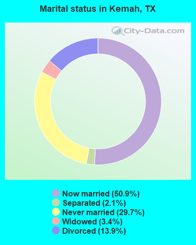
- Never married: 29.7%
- Now married: 50.9%
- Separated: 2.1%
- Widowed: 3.4%
- Divorced: 13.9%
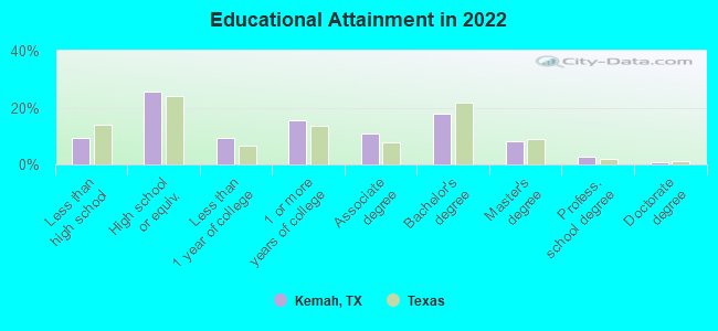
For population 25 years and over in Kemah:
- High school or higher: 90.7%
- Bachelor's degree or higher: 28.4%
- Graduate or professional degree: 10.9%
- Unemployed: 3.6%
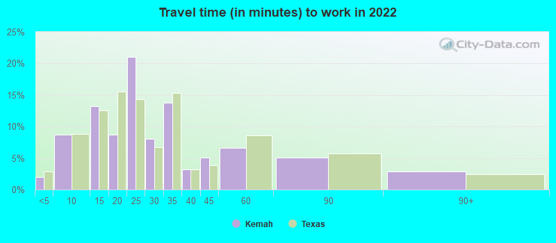
- Mean travel time to work (commute): 27.4 minutes
| Here: | 12.2 |
| Texas average: | 14.0 |
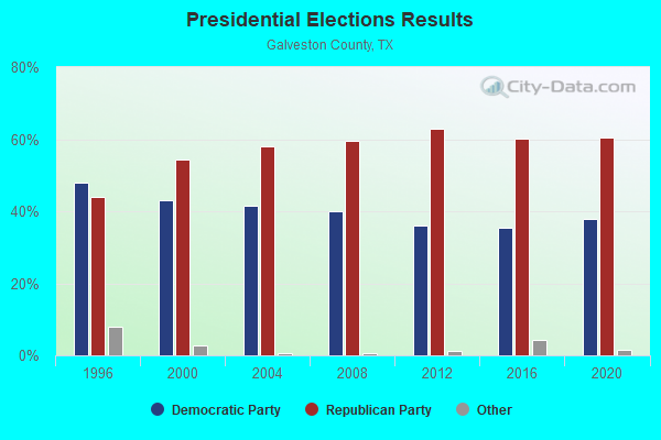
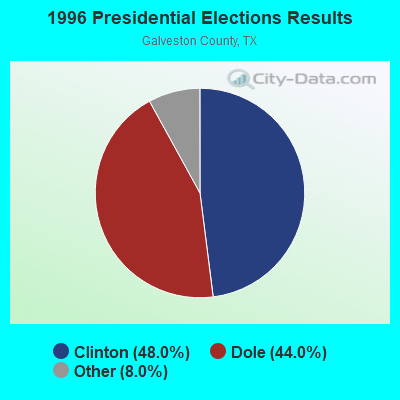
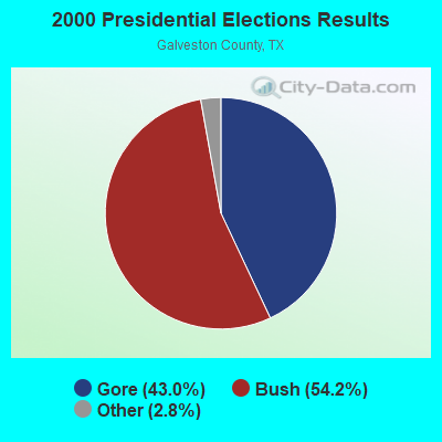
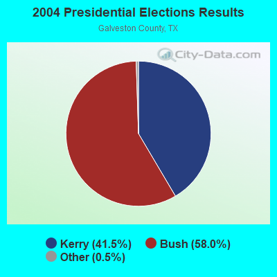
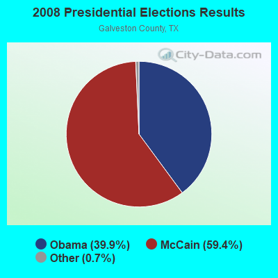
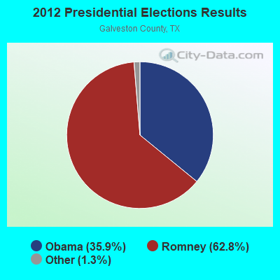
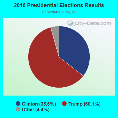
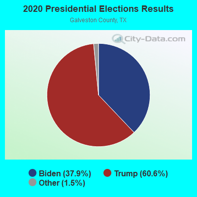
Graphs represent county-level data. Detailed 2008 Election Results
Religion statistics for Kemah, TX (based on Galveston County data)
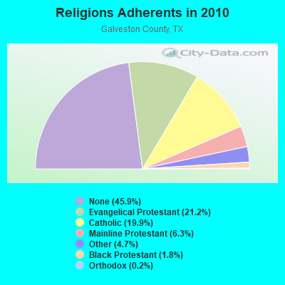
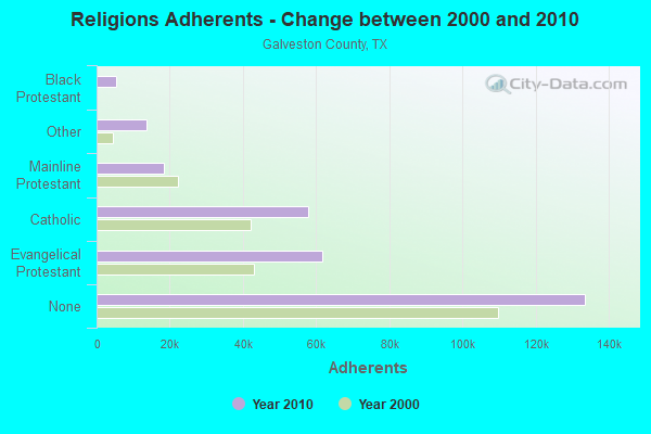
| Religion | Adherents | Congregations |
|---|---|---|
| Evangelical Protestant | 61,765 | 195 |
| Catholic | 57,907 | 8 |
| Mainline Protestant | 18,373 | 50 |
| Other | 13,728 | 26 |
| Black Protestant | 5,373 | 17 |
| Orthodox | 559 | 3 |
| None | 133,604 | - |
Food Environment Statistics:
| This county: | 1.70 / 10,000 pop. |
| Texas: | 1.47 / 10,000 pop. |
| This county: | 0.18 / 10,000 pop. |
| State: | 0.14 / 10,000 pop. |
| This county: | 1.41 / 10,000 pop. |
| Texas: | 1.11 / 10,000 pop. |
| This county: | 4.45 / 10,000 pop. |
| Texas: | 3.95 / 10,000 pop. |
| This county: | 6.89 / 10,000 pop. |
| Texas: | 6.13 / 10,000 pop. |
| Galveston County: | 10.1% |
| Texas: | 8.9% |
| This county: | 28.4% |
| Texas: | 26.6% |
| This county: | 16.7% |
| Texas: | 15.7% |
Health and Nutrition:
| Kemah: | 46.4% |
| Texas: | 48.6% |
| Here: | 44.6% |
| Texas: | 47.4% |
| Here: | 28.5 |
| Texas: | 28.5 |
| Kemah: | 20.8% |
| Texas: | 20.6% |
| This city: | 10.6% |
| Texas: | 10.3% |
| Kemah: | 6.8 |
| Texas: | 6.8 |
| Kemah: | 30.6% |
| Texas: | 33.1% |
| This city: | 56.4% |
| State: | 56.2% |
| Here: | 80.5% |
| Texas: | 80.7% |
More about Health and Nutrition of Kemah, TX Residents
| Local government employment and payroll (March 2022) | |||||
| Function | Full-time employees | Monthly full-time payroll | Average yearly full-time wage | Part-time employees | Monthly part-time payroll |
|---|---|---|---|---|---|
| Police Protection - Officers | 21 | $114,159 | $65,234 | 1 | $2,919 |
| Police - Other | 5 | $21,436 | $51,446 | 2 | $3,655 |
| Other Government Administration | 5 | $34,402 | $82,565 | 1 | $1,162 |
| Solid Waste Management | 4 | $18,191 | $54,573 | 0 | $0 |
| Financial Administration | 2 | $13,997 | $83,982 | 0 | $0 |
| Judicial and Legal | 1 | $3,975 | $47,700 | 1 | $1,502 |
| Totals for Government | 38 | $206,160 | $65,103 | 5 | $9,237 |
Kemah government finances - Expenditure in 2017 (per resident):
- Current Operations - Police Protection: $2,127,000 ($1186.94)
Financial Administration: $1,269,000 ($708.15)
Parks and Recreation: $886,000 ($494.42)
Judicial and Legal Services: $253,000 ($141.18)
Central Staff Services: $107,000 ($59.71)
General - Other: $54,000 ($30.13)
- Total Salaries and Wages: $2,225,000 ($1241.63)
Kemah government finances - Revenue in 2017 (per resident):
- Charges - Parking Facilities: $58,000 ($32.37)
- Local Intergovernmental - General Local Government Support: $250,000 ($139.51)
- Miscellaneous - Fines and Forfeits: $420,000 ($234.38)
Rents: $45,000 ($25.11)
General Revenue - Other: $26,000 ($14.51)
Sale of Property: $24,000 ($13.39)
- State Intergovernmental - General Local Government Support: $193,000 ($107.70)
Other: $8,000 ($4.46)
Highways: $3,000 ($1.67)
- Tax - General Sales and Gross Receipts: $2,777,000 ($1549.67)
Property: $673,000 ($375.56)
Public Utilities Sales: $251,000 ($140.07)
Occupation and Business License - Other: $142,000 ($79.24)
Alcoholic Beverage License: $9,000 ($5.02)
Kemah government finances - Cash and Securities in 2017 (per resident):
- Other Funds - Cash and Securities: $3,924,000 ($2189.73)
8.54% of this county's 2021 resident taxpayers lived in other counties in 2020 ($73,500 average adjusted gross income)
| Here: | 8.54% |
| Texas average: | 8.12% |
0.02% of residents moved from foreign countries ($187 average AGI)
Galveston County: 0.02% Texas average: 0.04%
Top counties from which taxpayers relocated into this county between 2020 and 2021:
| from Harris County, TX | |
| from Brazoria County, TX | |
| from Fort Bend County, TX |
7.72% of this county's 2020 resident taxpayers moved to other counties in 2021 ($74,429 average adjusted gross income)
| Here: | 7.72% |
| Texas average: | 7.40% |
0.02% of residents moved to foreign countries ($137 average AGI)
Galveston County: 0.02% Texas average: 0.03%
Top counties to which taxpayers relocated from this county between 2020 and 2021:
| to Harris County, TX | |
| to Brazoria County, TX | |
| to Montgomery County, TX |
| Businesses in Kemah, TX | ||||
| Name | Count | Name | Count | |
|---|---|---|---|---|
| Dairy Queen | 1 | RadioShack | 1 | |
| Days Inn | 1 | SONIC Drive-In | 1 | |
| FedEx | 2 | Starbucks | 2 | |
| GameStop | 1 | Subway | 1 | |
| H&R Block | 1 | Super 8 | 1 | |
| Holiday Inn | 1 | T-Mobile | 2 | |
| Jack In The Box | 1 | True Value | 1 | |
| McDonald's | 1 | UPS | 2 | |
| Office Depot | 1 | Walgreens | 1 | |
| Payless | 1 | Walmart | 1 | |
| Pier 1 Imports | 1 | |||
Strongest AM radio stations in Kemah:
- KTRH (740 AM; 50 kW; HOUSTON, TX; Owner: AMFM TEXAS LICENSES LIMITED PARTNERSHIP)
- KYST (920 AM; 5 kW; TEXAS CITY, TX; Owner: HISPANIC BROADCASTING, INC.)
- KILE (1560 AM; 50 kW; BELLAIRE, TX; Owner: THE RAFTT CORPORATION)
- KGOL (1180 AM; 50 kW; HUMBLE, TX; Owner: ENTRAVISION HOLDINGS, LLC)
- KXYZ (1320 AM; 5 kW; HOUSTON, TX; Owner: BLAYA INC.)
- KWWJ (1360 AM; 5 kW; BAYTOWN, TX; Owner: SALT OF THE EARTH BROADCASTING, INC.)
- KLAT (1010 AM; 10 kW; HOUSTON, TX; Owner: TICHENOR LICENSE CORPORATION ("TLC"))
- KLVL (1480 AM; 3 kW; PASADENA, TX; Owner: SIGA BROADCASTING CORP.)
- KPRC (950 AM; 5 kW; HOUSTON, TX; Owner: CCB TEXAS LICENSES, L.P.)
- KTEK (1110 AM; daytime; 2 kW; ALVIN, TX; Owner: SOUTH TEXAS BROADCASTING, INC.)
- KCOH (1430 AM; 5 kW; HOUSTON, TX; Owner: KCOH, INC.)
- KEYH (850 AM; 10 kW; HOUSTON, TX; Owner: LIBERMAN BROADCASTING OF HOUSTON LICENSE CORP.)
- KHCB (1400 AM; 1 kW; GALVESTON, TX; Owner: HOUSTON CHRISTIAN BROADCASTERS, INC.)
Strongest FM radio stations in Kemah:
- K217DJ (91.3 FM; KEMAH, TX; Owner: BEST MEDIA INC.)
- KLDE (107.5 FM; LAKE JACKSON, TX; Owner: CXR HOLDINGS, INC.)
- KOVE-FM (106.5 FM; GALVESTON, TX; Owner: HBC LICENSE CORPORATION)
- KJIC (90.5 FM; SANTA FE, TX; Owner: COMMUNITY RADIO, INC.)
- KRBE (104.1 FM; HOUSTON, TX; Owner: KRBE LICO, INC.)
- KBXX (97.9 FM; HOUSTON, TX; Owner: RADIO ONE LICENSES, LLC)
- KHJZ-FM (95.7 FM; HOUSTON, TX; Owner: TEXAS INFINITY BROADCASTING L.P.)
- KHMX (96.5 FM; HOUSTON, TX; Owner: CITICASTERS LICENSES, L.P.)
- KILT-FM (100.3 FM; HOUSTON, TX; Owner: TEXAS INFINITY BROADCASTING L.P.)
- KKBQ-FM (92.9 FM; PASADENA, TX; Owner: CXR HOLDINGS, INC.)
- KLOL (101.1 FM; HOUSTON, TX; Owner: AMFM TEXAS LICENSES LIMITED PARTNERSHIP)
- KODA (99.1 FM; HOUSTON, TX; Owner: AMFM TEXAS LICENSES LIMITED PARTNERSHIP)
- KTBZ-FM (94.5 FM; HOUSTON, TX; Owner: AMFM TEXAS LICENSES LIMITED PARTNERSHIP)
- KUHF (88.7 FM; HOUSTON, TX; Owner: UNIVERSITY OF HOUSTON SYSTEM)
- KMJQ (102.1 FM; HOUSTON, TX; Owner: RADIO ONE LICENSES, LLC)
- KKRW (93.7 FM; HOUSTON, TX; Owner: CAPSTAR TX LIMITED PARTNERSHIP)
- KHCB-FM (105.7 FM; HOUSTON, TX; Owner: HOUSTON CHRISTIAN BROADCASTERS, INC.)
- KLTN (102.9 FM; HOUSTON, TX; Owner: HBC HOUSTON LICENSE CORPORATION)
- KPTY (104.9 FM; MISSOURI CITY, TX; Owner: TICHENOR LICENSE CORPORATION ("TLC"))
- KOBT (100.7 FM; WINNIE, TX; Owner: TICHENOR LICENSE CORPORATION ("TLC"))
TV broadcast stations around Kemah:
- KJIB-LP (Channel 5; CLEAR LAKE CITY, TX; Owner: FAR EASTERN TELECASTERS)
- KTMD (Channel 48; GALVESTON, TX; Owner: TELEMUNDO OF TEXAS PARTNERSHIP, LP)
- KLTJ (Channel 22; GALVESTON, TX; Owner: WORD OF GOD FELLOWSHIP, INC.)
- KAZH (Channel 57; BAYTOWN, TX; Owner: KAZH LICENSE, LLC)
- KHOU-TV (Channel 11; HOUSTON, TX; Owner: KHOU-TV, L.P.)
- KPRC-TV (Channel 2; HOUSTON, TX; Owner: POST-NEWSWEEK STATIONS, HOUSTON, LP)
- KRIV (Channel 26; HOUSTON, TX; Owner: FOX TELEVISION STATIONS, INC.)
- KNWS-TV (Channel 51; KATY, TX; Owner: JOHNSON BROADCASTING, INC.)
- KTRK-TV (Channel 13; HOUSTON, TX; Owner: KTRK TELEVISION, INC.)
- KHWB (Channel 39; HOUSTON, TX; Owner: KHWB, INC.)
- KXLN-TV (Channel 45; ROSENBERG, TX; Owner: KXLN LICENSE PARTNERSHIP, L.P.)
- KPXB (Channel 49; CONROE, TX; Owner: PAXSON HOUSTON LICENSE, INC.)
- KTBU (Channel 55; CONROE, TX; Owner: HUMANITY INTERESTED MEDIA, INC.)
- KFTH (Channel 67; ALVIN, TX; Owner: TELEFUTURA HOUSTON LLC)
- KTXH (Channel 20; HOUSTON, TX; Owner: FOX TELEVISION STATIONS, INC.)
- KZJL (Channel 61; HOUSTON, TX; Owner: KZJL LICENSE CORP.)
- KETH (Channel 14; HOUSTON, TX; Owner: COMMUNITY EDUCATIONAL TV, INC.)
- KUHT (Channel 8; HOUSTON, TX; Owner: UNIVERSITY OF HOUSTON SYSTEM)
- KVDO-LP (Channel 69; CLEAR LAKE, TX; Owner: FAR EASTERN TELECASTERS)
- KBPX-LP (Channel 33; HOUSTON, TX; Owner: PAXSON COMMUNICATIONS LPTV, INC.)
- KVQT-LP (Channel 24; HOUSTON, TX; Owner: C. DOWEN JOHNSON)
- KHMV-LP (Channel 28; HOUSTON, TX; Owner: PAPPAS TELECASTING OF THE GULF COAST, A CALIFORNIA LP)
- KVVV-LP (Channel 53; HOUSTON, TX; Owner: KAZH LICENSE, LLC)
- KVIT-LP (Channel 28; VICTORIA, TX; Owner: CLUB COMMUNICATIONS)
- K30CV (Channel 30; HOUSTON, TX; Owner: BROADCASTING SYSTEMS, INC.)
FCC Registered Cell Phone Towers:
1 (See the full list of FCC Registered Cell Phone Towers in Kemah)FCC Registered Antenna Towers:
30 (See the full list of FCC Registered Antenna Towers)FCC Registered Broadcast Land Mobile Towers:
4- City Hall (Lat: 29.543556 Lon: -95.018806), Call Sign: KWF879, Licensee ID: L00087465,
Assigned Frequencies: 453.725 MHz, 453.725 MHz, Grant Date: 02/18/1999, Expiration Date: 01/24/2004, Cancellation Date: 03/28/2004, Registrant: City Of Kemah, 1401 Hwy 146, Kemah, TX 77565
- Fm 2094 & Hwy 146 (Lat: 29.541056 Lon: -95.019917), Call Sign: WPYN806,
Assigned Frequencies: 468.762 MHz, 468.837 MHz, 469.137 MHz, 469.462 MHz, 469.637 MHz, 469.662 MHz, 469.887 MHz, 457.512 MHz, 457.537 MHz, 457.562 MHz, 457.587 MHz, 457.612 MHz, Grant Date: 09/18/2013, Expiration Date: 09/17/2023, Cancellation Date: 11/18/2023, Certifier: Donna Laney, Registrant: Taco Cabana, Inc., 8918 Tesoro Dr., #200, San Antonio, TX 78217, Phone: (210) 283-5518, Fax: (210) 804-2328, Email:
- Sh 146 At Kemah Bridge (Lat: 29.590000 Lon: -95.356389), Type: Mast, Structure height: 3 m, Overall height: 4.6 m, Call Sign: WPZX513,
Assigned Frequencies: 171.825 MHz, Grant Date: 05/12/2014, Expiration Date: 04/05/2024, Cancellation Date: 11/05/2015, Certifier: Frank Gutierrez, Registrant: Harris County Flood Control District, 9900 Northwest Freeway, Houston, TX 77092, Phone: (713) 316-3609, Fax: (713) 881-3077, Email:
- Lat: 29.876111 Lon: -95.018333, Call Sign: WQBF780,
Assigned Frequencies: 452.062 MHz, 452.087 MHz, 452.187 MHz, 452.662 MHz, Grant Date: 09/30/2004, Expiration Date: 09/30/2014, Cancellation Date: 12/06/2014, Certifier: Curtis Eubank, Registrant: Tfmcomm, Inc., 125 S.W. Jackson, Topeka, KS 66603, Phone: (785) 233-2343, Fax: (785) 234-6848
FCC Registered Microwave Towers:
9 (See the full list of FCC Registered Microwave Towers in this town)FCC Registered Maritime Coast & Aviation Ground Towers:
4 (See the full list of FCC Registered Maritime Coast & Aviation Ground Towers)FCC Registered Amateur Radio Licenses:
95 (See the full list of FCC Registered Amateur Radio Licenses in Kemah)FAA Registered Aircraft Manufacturers and Dealers:
1 (See the full list of FAA Registered Manufacturers and Dealers in Kemah)FAA Registered Aircraft:
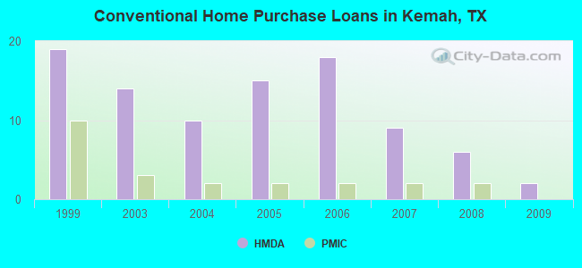
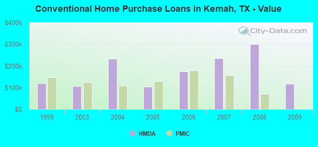
21 (See the full list of FAA Registered Aircraft)| Home Mortgage Disclosure Act Aggregated Statistics For Year 2009 (Based on 1 partial tract) | ||||||||||||
| A) FHA, FSA/RHS & VA Home Purchase Loans | B) Conventional Home Purchase Loans | C) Refinancings | D) Home Improvement Loans | F) Non-occupant Loans on < 5 Family Dwellings (A B C & D) | G) Loans On Manufactured Home Dwelling (A B C & D) | |||||||
|---|---|---|---|---|---|---|---|---|---|---|---|---|
| Number | Average Value | Number | Average Value | Number | Average Value | Number | Average Value | Number | Average Value | Number | Average Value | |
| LOANS ORIGINATED | 2 | $121,755 | 2 | $117,460 | 6 | $333,853 | 2 | $38,145 | 3 | $284,597 | 0 | $0 |
| APPLICATIONS APPROVED, NOT ACCEPTED | 0 | $0 | 0 | $0 | 0 | $0 | 0 | $0 | 0 | $0 | 0 | $0 |
| APPLICATIONS DENIED | 1 | $49,510 | 2 | $386,225 | 3 | $257,317 | 1 | $25,260 | 0 | $0 | 1 | $32,840 |
| APPLICATIONS WITHDRAWN | 1 | $48,500 | 1 | $301,600 | 1 | $138,420 | 0 | $0 | 0 | $0 | 0 | $0 |
| FILES CLOSED FOR INCOMPLETENESS | 0 | $0 | 1 | $95,990 | 1 | $89,930 | 0 | $0 | 0 | $0 | 0 | $0 |
Detailed HMDA statistics for the following Tracts: 7216.00
| Private Mortgage Insurance Companies Aggregated Statistics For Year 2009 (Based on 1 partial tract) | ||||
| A) Conventional Home Purchase Loans | C) Non-occupant Loans on < 5 Family Dwellings (A & B) | |||
|---|---|---|---|---|
| Number | Average Value | Number | Average Value | |
| LOANS ORIGINATED | 0 | $0 | 0 | $0 |
| APPLICATIONS APPROVED, NOT ACCEPTED | 1 | $223,800 | 1 | $77,300 |
| APPLICATIONS DENIED | 0 | $0 | 0 | $0 |
| APPLICATIONS WITHDRAWN | 0 | $0 | 0 | $0 |
| FILES CLOSED FOR INCOMPLETENESS | 0 | $0 | 0 | $0 |
Detailed PMIC statistics for the following Tracts: 7216.00
2002 - 2018 National Fire Incident Reporting System (NFIRS) incidents
- Fire incident types reported to NFIRS in Kemah, TX
- 12030.2%Structure Fires
- 11027.6%Mobile Property/Vehicle Fires
- 11027.6%Outside Fires
- 5814.6%Other
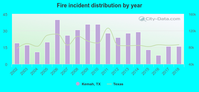 Based on the data from the years 2002 - 2018 the average number of fire incidents per year is 23. The highest number of fires - 40 took place in 2006, and the least - 8 in 2016. The data has a decreasing trend.
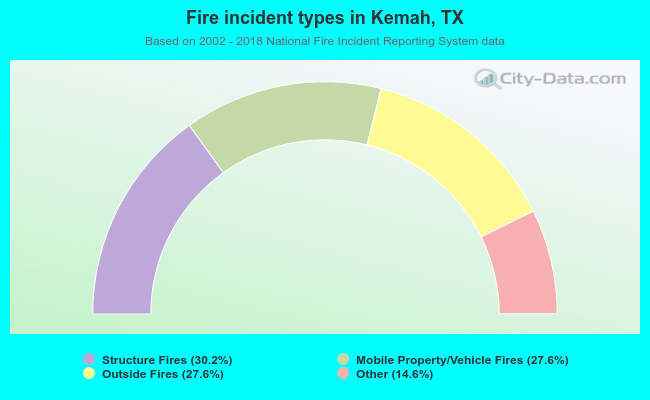 When looking into fire subcategories, the most reports belonged to: Structure Fires (30.2%), and Mobile Property/Vehicle Fires (27.6%).
Fire-safe hotels and motels in Kemah, Texas:
- Passport Inn & Suites, 601 Texas Ave, Kemah, Texas 77565 , Phone: (281) 334-4855, Fax: (281) 334-5573
- Holiday Inn Kemah, 805 Harris Ave, Kemah, Texas 77565 , Phone: (281) 334-0003, Fax: (281) 334-0004
- Super 8, 1413 Hwy 146, Kemah, Texas 77565 , Phone: (281) 549-4118, Fax: (281) 957-9482
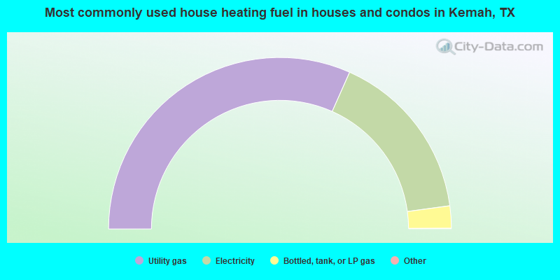
- 63.4%Utility gas
- 32.4%Electricity
- 4.2%Bottled, tank, or LP gas
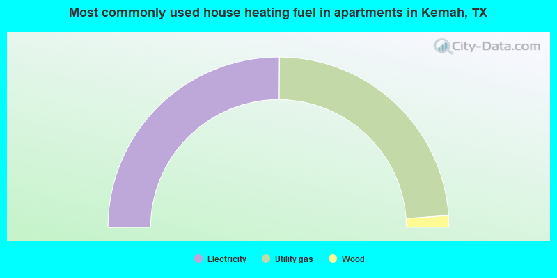
- 50.2%Electricity
- 47.6%Utility gas
- 2.2%Wood
Kemah compared to Texas state average:
- Unemployed percentage significantly below state average.
- Black race population percentage below state average.
- Median age above state average.
- Foreign-born population percentage below state average.
- Renting percentage below state average.
- Length of stay since moving in significantly above state average.
Kemah on our top lists:
- #10 on the list of "Top 101 cities with the most residents born in Born at sea (population 500+)"
- #42 on the list of "Top 101 cities with the most residents born in Argentina (population 500+)"
- #50 on the list of "Top 101 cities with the most residents born in Costa Rica (population 500+)"
- #14 on the list of "Top 101 counties with the largest decrease in the number of infant deaths per 1000 residents 2000-2006 to 2007-2013 (pop. 50,000+)"
- #30 on the list of "Top 101 counties with the lowest number of infant deaths per 1000 residents 2007-2013 (pop. 50,000+)"
- #35 on the list of "Top 101 counties with the lowest Nitrogen Dioxide air pollution readings in 2012 (ppm)"
- #48 on the list of "Top 101 counties with the lowest surface withdrawal of fresh water for public supply"
- #72 on the list of "Top 101 counties with the largest decrease in the number of deaths per 1000 residents 2000-2006 to 2007-2013 (pop. 50,000+)"

|
|
Total of 100 patent applications in 2008-2024.