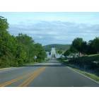
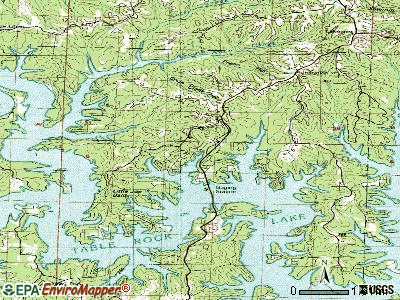
Kimberling City, Missouri
Kimberling City: Kimberling City On Table Rock Lake

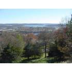
Kimberling City
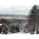
Kimberling City: First Snow of the Winter Season In The Ozarks
Kimberling City: February 2006

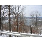
Kimberling City: sunset on Table Rock Lake, near the bridge

Kimberling City: Kimberling City Bridge, Kimberling City, MO - 2004
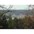
Kimberling City: Kimberling City Bridge on Table Rock Lake

Kimberling City: Kimberling City Bridge
Kimberling City: the bridge

Kimberling City: Day break view of Table Rock Lake from Kimberling Inn

Kimberling City: Day break view of Table Rock Lake from Kimberling Inn Condo unit 305.
- see
13
more - add
your
Submit your own pictures of this city and show them to the world
- OSM Map
- General Map
- Google Map
- MSN Map
Population change since 2000: +6.0%
 |
| Males: 1,111 | |
| Females: 1,277 |
| Median resident age: | 59.9 years |
| Missouri median age: | 39.1 years |
Zip codes: 65686.
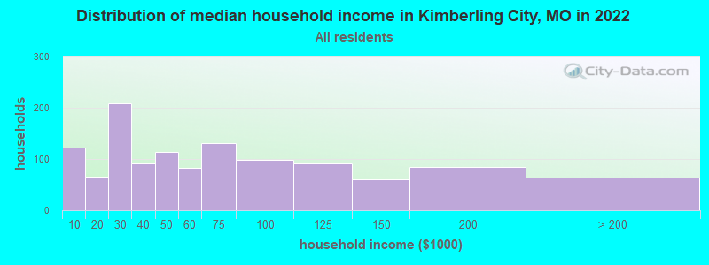
| Kimberling City: | $50,592 |
| MO: | $64,811 |
Estimated per capita income in 2022: $35,274 (it was $19,715 in 2000)
Kimberling City city income, earnings, and wages data
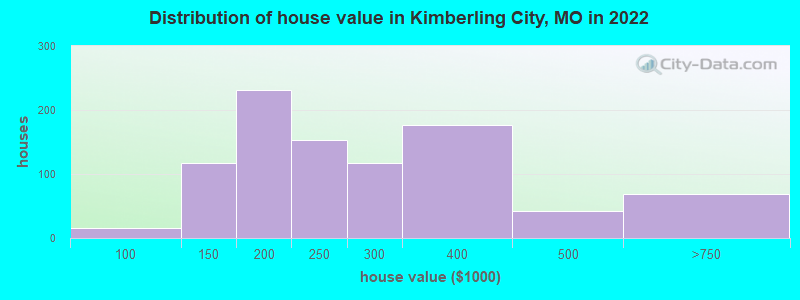
Estimated median house or condo value in 2022: $238,284 (it was $109,900 in 2000)
| Kimberling City: | $238,284 |
| MO: | $221,200 |
Mean prices in 2022: all housing units: $281,051; detached houses: $311,111; townhouses or other attached units: $352,353; in 2-unit structures: $42,415; in 3-to-4-unit structures: $179,408; in 5-or-more-unit structures: $264,099; mobile homes: $63,966; occupied boats, rvs, vans, etc.: $6,795
Median gross rent in 2022: $857.
Kimberling City, MO residents, houses, and apartments details
(13.6% for White Non-Hispanic residents, 27.3% for two or more races residents)
Detailed information about poverty and poor residents in Kimberling City, MO


- 2,44092.6%White alone
- 1485.6%Two or more races
- 291.1%Asian alone
- 200.8%Hispanic
Races in Kimberling City detailed stats: ancestries, foreign born residents, place of birth
According to our research of Missouri and other state lists, there were 8 registered sex offenders living in Kimberling City, Missouri as of April 28, 2024.
The ratio of all residents to sex offenders in Kimberling City is 327 to 1.
The ratio of registered sex offenders to all residents in this city is near the state average.
Type |
2009 |
2010 |
2011 |
2012 |
2013 |
2014 |
2015 |
2016 |
2017 |
2018 |
2019 |
2020 |
2021 |
2022 |
|---|---|---|---|---|---|---|---|---|---|---|---|---|---|---|
| Murders (per 100,000) | 0 (0.0) | 0 (0.0) | 0 (0.0) | 0 (0.0) | 0 (0.0) | 0 (0.0) | 1 (43.3) | 0 (0.0) | 0 (0.0) | 0 (0.0) | 0 (0.0) | 0 (0.0) | 0 (0.0) | 0 (0.0) |
| Rapes (per 100,000) | 0 (0.0) | 1 (41.7) | 0 (0.0) | 0 (0.0) | 0 (0.0) | 0 (0.0) | 1 (43.3) | 0 (0.0) | 0 (0.0) | 0 (0.0) | 2 (87.5) | 0 (0.0) | 0 (0.0) | 0 (0.0) |
| Robberies (per 100,000) | 0 (0.0) | 0 (0.0) | 0 (0.0) | 0 (0.0) | 0 (0.0) | 1 (43.3) | 0 (0.0) | 0 (0.0) | 0 (0.0) | 0 (0.0) | 0 (0.0) | 0 (0.0) | 0 (0.0) | 0 (0.0) |
| Assaults (per 100,000) | 3 (121.7) | 2 (83.3) | 0 (0.0) | 2 (83.0) | 7 (301.1) | 7 (303.3) | 4 (173.0) | 7 (305.7) | 5 (218.1) | 12 (520.4) | 6 (262.5) | 3 (131.2) | 2 (86.2) | 0 (0.0) |
| Burglaries (per 100,000) | 12 (486.6) | 11 (458.3) | 4 (166.0) | 8 (331.8) | 12 (516.1) | 10 (433.3) | 3 (129.8) | 1 (43.7) | 4 (174.4) | 9 (390.3) | 0 (0.0) | 2 (87.5) | 2 (86.2) | 0 (0.0) |
| Thefts (per 100,000) | 37 (1,500) | 22 (916.7) | 32 (1,328) | 26 (1,078) | 25 (1,075) | 33 (1,430) | 24 (1,038) | 26 (1,135) | 25 (1,090) | 31 (1,344) | 29 (1,269) | 14 (612.4) | 8 (344.7) | 0 (0.0) |
| Auto thefts (per 100,000) | 2 (81.1) | 1 (41.7) | 0 (0.0) | 1 (41.5) | 2 (86.0) | 2 (86.7) | 0 (0.0) | 2 (87.3) | 1 (43.6) | 1 (43.4) | 4 (175.0) | 5 (218.7) | 1 (43.1) | 0 (0.0) |
| Arson (per 100,000) | 0 (0.0) | 0 (0.0) | 0 (0.0) | 0 (0.0) | 0 (0.0) | 0 (0.0) | 0 (0.0) | 0 (0.0) | 0 (0.0) | 0 (0.0) | 0 (0.0) | 1 (43.7) | 0 (0.0) | 0 (0.0) |
| City-Data.com crime index | 124.9 | 122.1 | 64.8 | 86.3 | 146.2 | 168.1 | 206.3 | 116.6 | 102.9 | 188.6 | 187.2 | 74.4 | 40.5 | 0.0 |
The City-Data.com crime index weighs serious crimes and violent crimes more heavily. Higher means more crime, U.S. average is 246.1. It adjusts for the number of visitors and daily workers commuting into cities.
Crime rate in Kimberling City detailed stats: murders, rapes, robberies, assaults, burglaries, thefts, arson
Full-time law enforcement employees in 2021, including police officers: 4 (4 officers - 3 male; 1 female).
| Officers per 1,000 residents here: | 1.72 |
| Missouri average: | 2.54 |
 Recent articles from our blog. Our writers, many of them Ph.D. graduates or candidates, create easy-to-read articles on a wide variety of topics.

 | small towns in the area (8 replies) |
| Moving to Branson less than 2 wks. What do I need to know? (4 replies) |
| From Florida to Missouri (8 replies) |
| Branson a nice place to retire? (16 replies) |
| Southern Missouri mountain views (24 replies) |
| Branson MO for retirement life? (31 replies) |
Latest news from Kimberling City, MO collected exclusively by city-data.com from local newspapers, TV, and radio stations
Kimberling City, MO City Guides:
Ancestries: American (17.7%), English (12.4%), German (10.5%), European (7.0%), Irish (5.2%), Italian (4.1%).
Current Local Time: CST time zone
Incorporated in 1973
Elevation: 1050 feet
Land area: 3.34 square miles.
Population density: 714 people per square mile (low).
54 residents are foreign born (1.1% Asia, 0.6% Latin America, 0.5% Europe).
| This city: | 2.0% |
| Missouri: | 4.2% |
Median real estate property taxes paid for housing units with mortgages in 2022: $1,028 (0.5%)
Median real estate property taxes paid for housing units with no mortgage in 2022: $1,192 (0.5%)
Nearest city with pop. 50,000+: Springfield, MO  (39.0 miles , pop. 151,580).
Nearest city with pop. 200,000+: Tulsa, OK (144.3 miles , pop. 393,049).
Nearest city with pop. 1,000,000+: Dallas, TX (327.3 miles , pop. 1,188,580).
Nearest cities:
), Latitude: 36.64 N, Longitude: 93.42 W
Area code: 417
Single-family new house construction building permits:
- 2022: 7 buildings, average cost: $244,800
- 2021: 8 buildings, average cost: $244,800
- 2020: 8 buildings, average cost: $226,000
- 2019: 7 buildings, average cost: $226,000
- 2018: 2 buildings, average cost: $118,000
- 2017: 2 buildings, average cost: $187,500
- 2016: 2 buildings, average cost: $208,900
- 2014: 1 building, cost: $250,000
- 2013: 1 building, cost: $200,000
- 2011: 1 building, cost: $110,000
- 2010: 1 building, cost: $200,000
- 2009: 1 building, cost: $160,000
- 2008: 8 buildings, average cost: $131,800
- 2007: 10 buildings, average cost: $171,700
- 2006: 6 buildings, average cost: $117,000
- 2005: 9 buildings, average cost: $113,400
- 2004: 31 buildings, average cost: $151,700
- 2003: 17 buildings, average cost: $124,000
- 2002: 14 buildings, average cost: $89,300
- 2001: 12 buildings, average cost: $121,000
- 2000: 17 buildings, average cost: $88,400
- 1999: 7 buildings, average cost: $69,100
- 1998: 15 buildings, average cost: $76,500
- 1997: 5 buildings, average cost: $111,000
| Here: | 4.0% |
| Missouri: | 2.8% |
- Accommodation & food services (14.2%)
- Educational services (10.7%)
- Construction (7.4%)
- Administrative & support & waste management services (7.4%)
- Arts, entertainment, recreation (7.2%)
- Finance & insurance (5.7%)
- Health care (5.4%)
- Construction (13.6%)
- Accommodation & food services (10.3%)
- Arts, entertainment, recreation (9.9%)
- Administrative & support & waste management services (8.3%)
- Real estate & rental & leasing (6.7%)
- Finance & insurance (6.2%)
- Building material & garden equipment & supplies dealers (4.8%)
- Accommodation & food services (18.2%)
- Educational services (17.9%)
- Health care (8.1%)
- Administrative & support & waste management services (6.5%)
- Professional, scientific, technical services (6.2%)
- Finance & insurance (5.3%)
- Department & other general merchandise stores (4.8%)
- Other sales and related occupations, including supervisors (8.4%)
- Information and record clerks, except customer service representatives (5.3%)
- Sales representatives, services, wholesale and manufacturing (5.2%)
- Preschool, kindergarten, elementary, and middle school teachers (4.6%)
- Retail sales workers, except cashiers (4.2%)
- Other office and administrative support workers, including supervisors (3.5%)
- Top executives (3.3%)
- Other sales and related occupations, including supervisors (12.9%)
- Sales representatives, services, wholesale and manufacturing (6.2%)
- Top executives (4.6%)
- Painters and paperhangers (4.6%)
- Supervisors, construction and extraction workers (4.1%)
- Carpenters (4.1%)
- Driver/sales workers and truck drivers (3.9%)
- Preschool, kindergarten, elementary, and middle school teachers (8.6%)
- Information and record clerks, except customer service representatives (7.7%)
- Other office and administrative support workers, including supervisors (5.5%)
- Retail sales workers, except cashiers (5.0%)
- Material recording, scheduling, dispatching, and distributing workers (5.0%)
- Secretaries and administrative assistants (4.5%)
- Customer service representatives (4.3%)
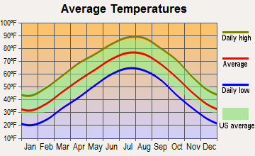
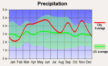
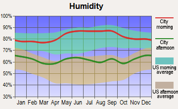
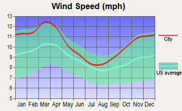
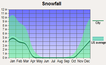
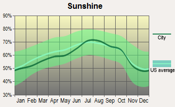
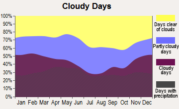
Average climate in Kimberling City, Missouri
Based on data reported by over 4,000 weather stations
|
|

Tornado activity:
Kimberling City-area historical tornado activity is near Missouri state average. It is 48% greater than the overall U.S. average.
On 11/29/1991, a category F4 (max. wind speeds 207-260 mph) tornado 32.4 miles away from the Kimberling City city center killed 2 people and injured 64 people and caused between $5,000,000 and $50,000,000 in damages.
On 3/24/1954, a category F3 (max. wind speeds 158-206 mph) tornado 14.7 miles away from the city center injured 2 people and caused between $5000 and $50,000 in damages.
Earthquake activity:
Kimberling City-area historical earthquake activity is significantly above Missouri state average. It is 584% greater than the overall U.S. average.On 9/3/2016 at 12:02:44, a magnitude 5.8 (5.8 MW, Depth: 3.5 mi, Class: Moderate, Intensity: VI - VII) earthquake occurred 195.4 miles away from Kimberling City center
On 11/6/2011 at 03:53:10, a magnitude 5.7 (5.7 MW, Depth: 3.2 mi) earthquake occurred 201.9 miles away from Kimberling City center
On 2/28/2011 at 05:00:50, a magnitude 4.7 (4.7 MW, Depth: 2.0 mi, Class: Light, Intensity: IV - V) earthquake occurred 112.3 miles away from Kimberling City center
On 5/4/2001 at 06:42:12, a magnitude 4.7 (4.2 MB, 4.7 LG, 4.5 LG) earthquake occurred 120.9 miles away from Kimberling City center
On 1/21/1982 at 00:33:54, a magnitude 4.7 (4.5 MB, 4.7 LG, 4.5 LG) earthquake occurred 122.5 miles away from Kimberling City center
On 3/25/1976 at 00:41:20, a magnitude 5.0 (4.9 MB, 5.0 LG) earthquake occurred 186.4 miles away from Kimberling City center
Magnitude types: regional Lg-wave magnitude (LG), body-wave magnitude (MB), moment magnitude (MW)
Natural disasters:
The number of natural disasters in Stone County (23) is greater than the US average (15).Major Disasters (Presidential) Declared: 15
Emergencies Declared: 6
Causes of natural disasters: Floods: 15, Storms: 14, Tornadoes: 12, Winter Storms: 5, Winds: 4, Drought: 1, Heavy Rain: 1, Hurricane: 1, Other: 1 (Note: some incidents may be assigned to more than one category).
Hospitals and medical centers in Kimberling City:
Other hospitals and medical centers near Kimberling City:
- HEALING HANDS HEALTH CARE, LLC (Home Health Center, about 9 miles away; BRANSON, MO)
- GOLDEN LIVINGCENTER-BRANSON (Nursing Home, about 11 miles away; BRANSON, MO)
- BRANSON DIALYSIS, LLC (Dialysis Facility, about 12 miles away; BRANSON, MO)
- COMMUNITY HOSPICES OF AMERICA (Hospital, about 12 miles away; BRANSON, MO)
Airports located in Kimberling City:
- Kimberling Airport (MO64) (Runways: 1)
Colleges/universities with over 2000 students nearest to Kimberling City:
- Missouri State University-Springfield (about 40 miles; Springfield, MO; Full-time enrollment: 16,660)
- Ozarks Technical Community College (about 41 miles; Springfield, MO; FT enrollment: 10,356)
- Drury University (about 41 miles; Springfield, MO; FT enrollment: 3,902)
- Evangel University (about 42 miles; Springfield, MO; FT enrollment: 2,036)
- NorthWest Arkansas Community College (about 47 miles; Bentonville, AR; FT enrollment: 5,634)
- Crowder College (about 54 miles; Neosho, MO; FT enrollment: 3,675)
- University of Arkansas (about 59 miles; Fayetteville, AR; FT enrollment: 22,163)
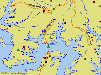
Points of interest:
Notable locations in Kimberling City: Fisher Creek Country Club (A), Kimberling City Area Community Center (B), Southern Stone County Fire Protection District Station 2 (C). Display/hide their locations on the map
Cemetery: Shepherd Cemetery (1). Display/hide its location on the map
Park in Kimberling City: Highway Thirteen Park (1). Display/hide its location on the map
Tourist attraction: Eagle Travel of the Ozarks (Tours & Charters; Kimberling City Shop).
Hotels: Garden Terrace Restaurant (11863 State Highway 13), Cove Resort (12049 State Highway 13), Lighthouse Lodge (51 Lake Road), Kimberling Arms Resort (11635 State Highway 13), A Kimberling Oaks Resort (31 Holiday Dr).
Birthplace of: Dave Wommack - Football coach.
Drinking water stations with addresses in Kimberling City and their reported violations in the past:
SCHOONER CREEK RESORT (Address: 27 SCHOONER CREEK RD , Population served: 80, Groundwater):Past monitoring violations:TABLE ROCK LAKE CAMPGROUND (Population served: 75, Groundwater):
- 9 routine major monitoring violations
- 2 minor monitoring violations
- One regular monitoring violation
Past health violations:SILVER BELL SUBDIVISION HOA INC (Population served: 50, Groundwater):Past monitoring violations:
- MCL, Monthly (TCR) - In APR-2011, Contaminant: Coliform. Follow-up actions: St BCA signed (MAR-13-2011), St Public Notif requested (MAY-04-2011), St Violation/Reminder Notice (MAY-04-2011), St Compliance achieved (2 times from AUG-05-2011 to FEB-01-2012), St Public Notif received (MAY-15-2012)
- MCL, Acute (TCR) - In JUL-2010, Contaminant: Coliform. Follow-up actions: St Boil Water Order (JUL-23-2010), St Public Notif issued (JUL-23-2010), St Formal NOV issued (JUL-23-2010), St Public Notif requested (JUL-23-2010), St Other (JUL-29-2010), St Public Notif received (JUL-29-2010), St Formal NOV issued (NOV-03-2010), St Public Notif requested (NOV-03-2010), St Compliance achieved (DEC-31-2010), St BCA signed (MAR-13-2011), St Compliance achieved (FEB-01-2012), St Public Notif received (MAY-15-2012)
- MCL, Monthly (TCR) - In JUL-2010, Contaminant: Coliform. Follow-up actions: St Violation/Reminder Notice (JUL-15-2010), St Public Notif requested (2 times from JUL-15-2010 to JUL-23-2010), St Formal NOV issued (JUL-23-2010), St Public Notif issued (SEP-23-2010), St Compliance achieved (DEC-31-2010), St BCA signed (MAR-13-2011), St Compliance achieved (FEB-01-2012), St Public Notif received (MAY-15-2012)
- MCL, Monthly (TCR) - In JUN-2010, Contaminant: Coliform. Follow-up actions: St Public Notif requested (JUL-06-2010), St Formal NOV issued (JUL-06-2010), St Violation/Reminder Notice (JUL-08-2010), St Public Notif requested (JUL-08-2010), St Public Notif received (JUL-19-2010), St Public Notif issued (SEP-23-2010), St Compliance achieved (DEC-31-2010), St BCA signed (MAR-13-2011), St Compliance achieved (FEB-01-2012), St Public Notif received (MAY-15-2012)
- MCL, Acute (TCR) - In JUN-2010, Contaminant: Coliform. Follow-up actions: St Public Notif requested (JUL-06-2010), St Formal NOV issued (JUL-06-2010), St Boil Water Order (JUL-06-2010), St Public Notif issued (JUL-06-2010), St Violation/Reminder Notice (JUL-07-2010), St Public Notif requested (JUL-07-2010), St Public Notif received (JUL-19-2010), St Other (JUL-20-2010), St Public Notif issued (SEP-23-2010), St Compliance achieved (DEC-31-2010), St BCA signed (MAR-13-2011), St Compliance achieved (FEB-01-2012), St Public Notif received (MAY-15-2012)
- Failure To Address Deficiency - In MAR-14-2010, Contaminant: GROUNDWATER RULE. Follow-up actions: St Compliance achieved (2 times from MAY-19-2010 to FEB-01-2012)
- 10 routine major monitoring violations
- One minor monitoring violation
- One regular monitoring violation
Past health violations:LIGHTHOUSE LODGE RESORT (Population served: 42, Groundwater):Past monitoring violations:
- MCL, Monthly (TCR) - In AUG-2007, Contaminant: Coliform. Follow-up actions: St Public Notif requested (AUG-31-2007), St Violation/Reminder Notice (AUG-31-2007), St Compliance achieved (JAN-22-2014)
- MCL, Monthly (TCR) - In JUL-2007, Contaminant: Coliform. Follow-up actions: St Violation/Reminder Notice (JUL-24-2007), St Public Notif requested (JUL-24-2007), St Public Notif received (AUG-01-2007), St Compliance achieved (JAN-22-2014)
- MCL, Monthly (TCR) - In JUN-2007, Contaminant: Coliform. Follow-up actions: St Violation/Reminder Notice (JUN-26-2007), St Public Notif requested (JUN-26-2007), St Compliance achieved (JAN-22-2014)
- One routine major monitoring violation
- 2 minor monitoring violations
Past health violations:WHISPERING WOODS (Population served: 32, Groundwater):Past monitoring violations:
- MCL, Monthly (TCR) - In OCT-2012, Contaminant: Coliform. Follow-up actions: St Public Notif requested (OCT-17-2012), St Formal NOV issued (OCT-17-2012), St Public Notif received (NOV-01-2012), St Compliance achieved (MAY-21-2013)
- MCL, Monthly (TCR) - In SEP-2012, Contaminant: Coliform. Follow-up actions: St Public Notif requested (SEP-26-2012), St Formal NOV issued (SEP-26-2012), St Public Notif received (NOV-01-2012), St Compliance achieved (MAY-21-2013)
- Monitoring, Source Water (GWR) - In OCT-01-2012, Contaminant: E. COLI. Follow-up actions: St Public Notif requested (OCT-19-2012), St Violation/Reminder Notice (OCT-19-2012), St Compliance achieved (MAY-21-2013)
- 2 minor monitoring violations
Past health violations:CHRISTIAN ASSOCIATES OF TABLE ROCK LAKE (Population served: 30, Groundwater):Past monitoring violations:
- MCL, Monthly (TCR) - In OCT-2009, Contaminant: Coliform. Follow-up actions: St Public Notif requested (NOV-18-2009), St Violation/Reminder Notice (NOV-18-2009), St Public Notif received (DEC-24-2009), St Compliance achieved (JAN-22-2014)
- MCL, Monthly (TCR) - In AUG-2007, Contaminant: Coliform. Follow-up actions: St Public Notif requested (SEP-04-2007), St Violation/Reminder Notice (SEP-04-2007), St Public Notif received (OCT-11-2007), St Compliance achieved (JAN-22-2014)
- MCL, Monthly (TCR) - In JUL-2007, Contaminant: Coliform. Follow-up actions: St Public Notif requested (AUG-03-2007), St Violation/Reminder Notice (AUG-03-2007), St Public Notif received (SEP-06-2007), St Compliance achieved (JAN-22-2014)
- One routine major monitoring violation
- One minor monitoring violation
Past health violations:THE ROCKS BAR AND GRILL (Population served: 25, Groundwater):Past monitoring violations:
- MCL, Acute (TCR) - In JUL-2008, Contaminant: Coliform. Follow-up actions: St Boil Water Order (JUL-29-2008), St Public Notif requested (JUL-29-2008), St Formal NOV issued (JUL-29-2008), St Public Notif issued (JUL-31-2008), St Other (AUG-04-2008), St Public Notif requested (AUG-06-2008), St Formal NOV issued (AUG-06-2008), St Compliance achieved (JAN-22-2014)
- MCL, Monthly (TCR) - In JUL-2008, Contaminant: Coliform. Follow-up actions: St Formal NOV issued (JUL-29-2008), St Public Notif requested (2 times from JUL-29-2008 to AUG-06-2008), St Violation/Reminder Notice (AUG-06-2008), St Compliance achieved (JAN-22-2014)
- MCL, Monthly (TCR) - In JUN-2007, Contaminant: Coliform. Follow-up actions: St Public Notif issued (JUN-21-2007), St Boil Water Order (JUN-21-2007), St Public Notif requested (JUN-21-2007), St Formal NOV issued (JUN-21-2007), St Compliance achieved (JUN-27-2007), St Public Notif requested (JUN-28-2007), St Violation/Reminder Notice (JUN-28-2007), St Public Notif received (JUL-02-2007)
- MCL, Acute (TCR) - In JUN-2007, Contaminant: Coliform. Follow-up actions: St Public Notif issued (JUN-21-2007), St Boil Water Order (JUN-21-2007), St Public Notif requested (JUN-21-2007), St Formal NOV issued (JUN-21-2007), St Compliance achieved (JUN-27-2007), St Public Notif requested (JUN-28-2007), St Formal NOV issued (JUN-28-2007), St Public Notif received (JUL-02-2007)
- Lead Consumer Notice - In JAN-01-2012, Contaminant: Lead and Copper Rule
- Lead Consumer Notice - In APR-01-2011, Contaminant: Lead and Copper Rule
- Lead Consumer Notice - In OCT-01-2010, Contaminant: Lead and Copper Rule
- Initial Tap Sampling for Pb and Cu - In JUL-01-2009, Contaminant: Lead and Copper Rule. Follow-up actions: St Compliance achieved (NOV-05-2010)
- One routine major monitoring violation
- 32 regular monitoring violations
Past health violations:FOREST GLEN/QUAIL RIDGE SUBD (Population served: 25, Groundwater):Past monitoring violations:
- MCL, Monthly (TCR) - In JUN-2013, Contaminant: Coliform. Follow-up actions: St Public Notif requested (JUL-19-2013), St Formal NOV issued (JUL-19-2013), St Public Notif received (JUL-29-2013), St Violation/Reminder Notice (SEP-17-2013), St Compliance achieved (NOV-20-2013), St Violation/Reminder Notice (APR-22-2014)
- MCL, Monthly (TCR) - In MAY-2013, Contaminant: Coliform. Follow-up actions: St Public Notif requested (JUN-11-2013), St Formal NOV issued (JUN-11-2013), St Violation/Reminder Notice (SEP-17-2013), St Compliance achieved (NOV-20-2013), St Public Notif received (JAN-14-2014), St Violation/Reminder Notice (APR-22-2014)
- MCL, Monthly (TCR) - In AUG-2010, Contaminant: Coliform. Follow-up actions: St Civil Case referred to AG (JUL-25-2006), St Public Notif requested (AUG-27-2010), St Violation/Reminder Notice (AUG-27-2010), St Compliance achieved (APR-21-2011)
- MCL, Monthly (TCR) - In JUL-2008, Contaminant: Coliform. Follow-up actions: St Civil Case referred to AG (JUL-25-2006), St Public Notif requested (AUG-07-2008), St Violation/Reminder Notice (AUG-07-2008), St Public Notif issued (2 times from JUN-01-2010 to SEP-23-2010), St Compliance achieved (2 times from SEP-30-2010 to APR-21-2011)
- Monitoring, Source Water (GWR) - In JUL-01-2013, Contaminant: E. COLI. Follow-up actions: St Violation/Reminder Notice (SEP-17-2013), St Compliance achieved (NOV-20-2013), St Violation/Reminder Notice (APR-22-2014)
- 14 routine major monitoring violations
- 3 minor monitoring violations
- One regular monitoring violation
Past health violations:Past monitoring violations:
- MCL, Monthly (TCR) - In NOV-2013, Contaminant: Coliform. Follow-up actions: St Public Notif requested (DEC-13-2013), St Formal NOV issued (DEC-13-2013), St Public Notif received (DEC-23-2013), St Formal NOV issued (JAN-16-2014), St Compliance achieved (FEB-13-2014), St BCA signed (FEB-28-2014)
- MCL, Monthly (TCR) - In OCT-2013, Contaminant: Coliform. Follow-up actions: St Public Notif requested (NOV-19-2013), St Formal NOV issued (NOV-19-2013), St Public Notif received (DEC-02-2013), St Formal NOV issued (JAN-16-2014), St Compliance achieved (FEB-13-2014), St BCA signed (FEB-28-2014)
- MCL, Monthly (TCR) - In MAY-2013, Contaminant: Coliform. Follow-up actions: St Public Notif received (JUN-03-2013), St Public Notif requested (JUN-07-2013), St Formal NOV issued (JUN-07-2013), St Compliance achieved (NOV-19-2013), St Formal NOV issued (JAN-16-2014), St BCA signed (FEB-28-2014)
- MCL, Acute (TCR) - In MAY-2013, Contaminant: Coliform. Follow-up actions: St Boil Water Order (MAY-30-2013), St Public Notif received (JUN-03-2013), St Other (JUN-06-2013), St Public Notif requested (JUN-07-2013), St Formal NOV issued (JUN-07-2013), St Compliance achieved (NOV-19-2013), St Formal NOV issued (JAN-16-2014), St BCA signed (FEB-28-2014)
- Monitoring, Source Water (GWR) - In OCT-01-2013, Contaminant: E. COLI. Follow-up actions: St Public Notif requested (OCT-28-2013), St Violation/Reminder Notice (OCT-28-2013), St Compliance achieved (NOV-19-2013), St Public Notif received (NOV-22-2013), St Formal NOV issued (JAN-16-2014), St BCA signed (FEB-28-2014)
- Monitoring, Repeat Major (TCR) - In SEP-2013, Contaminant: Coliform (TCR). Follow-up actions: St Public Notif requested (OCT-31-2013), St Violation/Reminder Notice (OCT-31-2013), St Compliance achieved (NOV-19-2013), St Public Notif received (NOV-22-2013), St Formal NOV issued (JAN-16-2014), St BCA signed (FEB-28-2014)
- Follow-up Or Routine LCR Tap M/R - In JAN-01-2004, Contaminant: Lead and Copper Rule. Follow-up actions: St Compliance achieved (SEP-30-2010)
- One minor monitoring violation
- 2 regular monitoring violations
Drinking water stations with addresses in Kimberling City that have no violations reported:
- PORT OF KIMBERLNG MARINA & CMPGRND (117) (Population served: 800, Primary Water Source Type: Groundwater)
- FOREST PARK/DEER PARK (Population served: 150, Primary Water Source Type: Groundwater)
- CANYON FOREST EAST AND WEST (Population served: 40, Primary Water Source Type: Groundwater)
- PORT OF KIMBERLNG MARINA & CMPGRND (118) (Population served: 25, Primary Water Source Type: Groundwater)
| This city: | 2.1 people |
| Missouri: | 2.5 people |
| This city: | 67.5% |
| Whole state: | 65.3% |
| This city: | 3.4% |
| Whole state: | 6.7% |
Likely homosexual households (counted as self-reported same-sex unmarried-partner households)
- Lesbian couples: 0.1% of all households
- Gay men: 0.5% of all households
Banks with branches in Kimberling City (2011 data):
- Metropolitan National Bank: Kimberling City Branch at 12661 State Highway 13, branch established on 1973/06/18. Info updated 2009/06/09: Bank assets: $472.7 mil, Deposits: $388.8 mil, headquarters in Springfield, MO, negative income in the last year, Commercial Lending Specialization, 12 total offices, Holding Company: Marshfield Investment Company Employee Stock Ownership Plan And Trust
- Great Southern Bank: Reeds Spring Branch at Highway 13 And 00, branch established on 1923/01/01. Info updated 2012/02/03: Bank assets: $3,788.7 mil, Deposits: $2,986.3 mil, headquarters in Reeds Spring, MO, positive income, Commercial Lending Specialization, 109 total offices, Holding Company: Great Southern Bancorp, Inc.
- Table Rock Community Bank: at Kimberling Village Professional Center, branch established on 2006/08/28. Info updated 2009/08/21: Bank assets: $48.2 mil, Deposits: $44.1 mil, local headquarters, positive income, Commercial Lending Specialization, 1 total offices, Holding Company: Table Rock Bancshares Corporation
- Peoples Bank of the Ozarks: Kimberling City Branch at 11892 State Hwy 13, branch established on 2001/03/12. Info updated 2006/11/03: Bank assets: $284.8 mil, Deposits: $237.1 mil, headquarters in Nixa, MO, negative income in the last year, Commercial Lending Specialization, 11 total offices, Holding Company: Peoples Service Company
For population 15 years and over in Kimberling City:
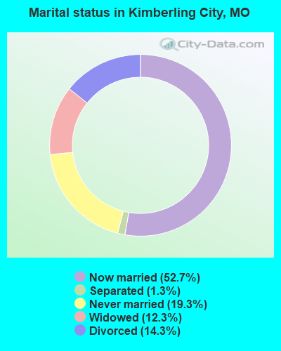
- Never married: 19.3%
- Now married: 52.7%
- Separated: 1.3%
- Widowed: 12.3%
- Divorced: 14.3%
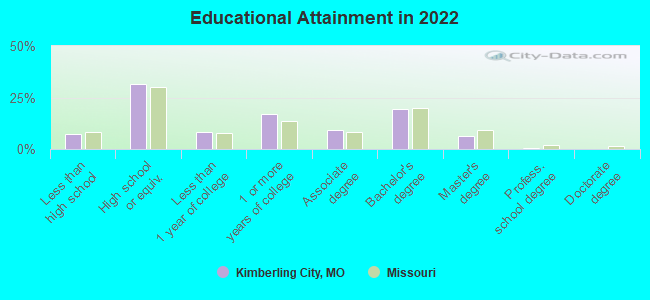
For population 25 years and over in Kimberling City:
- High school or higher: 92.4%
- Bachelor's degree or higher: 25.5%
- Graduate or professional degree: 6.9%
- Unemployed: 12.0%
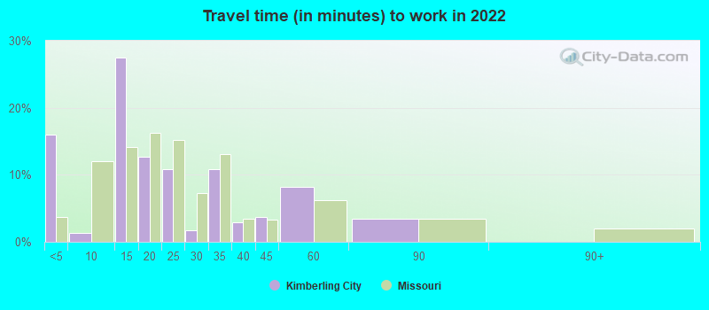
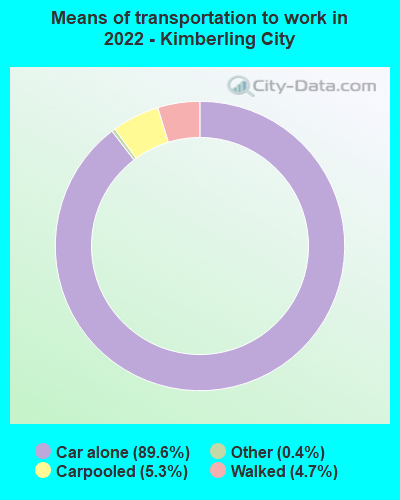
- Mean travel time to work (commute): 20.2 minutes
| Here: | 8.5 |
| Missouri average: | 11.1 |
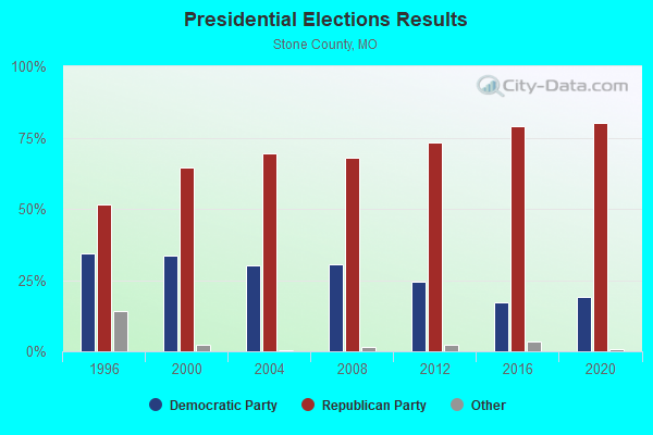
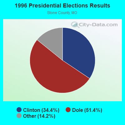
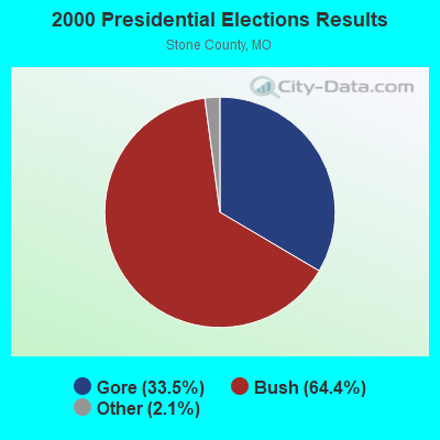

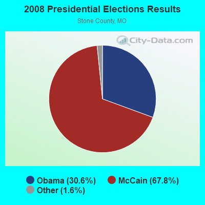
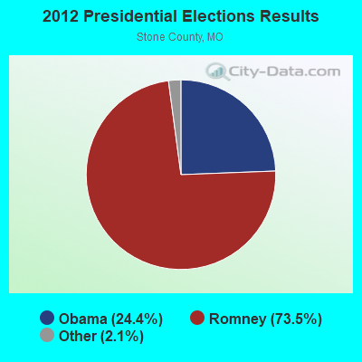
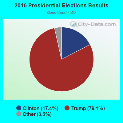
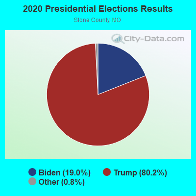
Graphs represent county-level data. Detailed 2008 Election Results
Political contributions by individuals in Kimberling City, MO
Religion statistics for Kimberling City, MO (based on Stone County data)
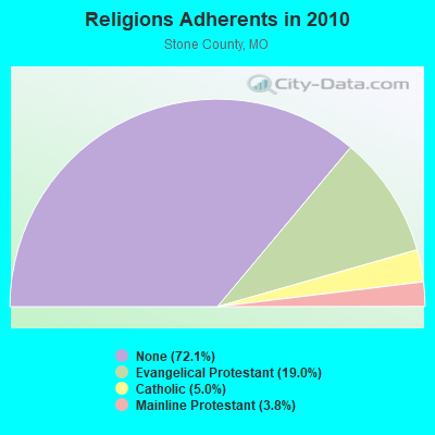
| Religion | Adherents | Congregations |
|---|---|---|
| Evangelical Protestant | 6,134 | 41 |
| Catholic | 1,620 | 1 |
| Mainline Protestant | 1,234 | 5 |
| Other | 6 | 1 |
| None | 23,208 | - |
Food Environment Statistics:
| Stone County: | 2.86 / 10,000 pop. |
| Missouri: | 1.88 / 10,000 pop. |
| Stone County: | 0.32 / 10,000 pop. |
| State: | 0.18 / 10,000 pop. |
| Stone County: | 0.95 / 10,000 pop. |
| Missouri: | 0.60 / 10,000 pop. |
| Stone County: | 6.35 / 10,000 pop. |
| State: | 4.34 / 10,000 pop. |
| This county: | 10.48 / 10,000 pop. |
| State: | 7.37 / 10,000 pop. |
| Stone County: | 9.9% |
| Missouri: | 8.8% |
| This county: | 29.0% |
| Missouri: | 29.6% |
| Here: | 10.8% |
| Missouri: | 13.5% |
Health and Nutrition:
| Here: | 58.5% |
| State: | 50.9% |
| This city: | 55.1% |
| State: | 48.6% |
| Kimberling City: | 27.8 |
| Missouri: | 28.7 |
| This city: | 16.9% |
| Missouri: | 20.6% |
| Kimberling City: | 8.2% |
| Missouri: | 10.1% |
| This city: | 7.2 |
| Missouri: | 6.8 |
| Kimberling City: | 36.2% |
| Missouri: | 34.3% |
| This city: | 61.6% |
| Missouri: | 57.5% |
| This city: | 76.0% |
| Missouri: | 79.3% |
More about Health and Nutrition of Kimberling City, MO Residents
| Local government employment and payroll (March 2022) | |||||
| Function | Full-time employees | Monthly full-time payroll | Average yearly full-time wage | Part-time employees | Monthly part-time payroll |
|---|---|---|---|---|---|
| Police Protection - Officers | 6 | $22,879 | $45,758 | 0 | $0 |
| Other Government Administration | 4 | $5,914 | $17,742 | 0 | $0 |
| Streets and Highways | 4 | $18,297 | $54,891 | 0 | $0 |
| Judicial and Legal | 0 | $0 | 1 | $2,808 | |
| Totals for Government | 14 | $47,090 | $40,363 | 1 | $2,808 |
Kimberling City government finances - Expenditure in 2017 (per resident):
- Current Operations - Sewerage: $777,000 ($325.38)
Regular Highways: $597,000 ($250.00)
Police Protection: $420,000 ($175.88)
Financial Administration: $264,000 ($110.55)
Judicial and Legal Services: $46,000 ($19.26)
Water Utilities: $15,000 ($6.28)
- General - Interest on Debt: $212,000 ($88.78)
- Total Salaries and Wages: $644,000 ($269.68)
Kimberling City government finances - Revenue in 2017 (per resident):
- Charges - Sewerage: $347,000 ($145.31)
- Miscellaneous - Fines and Forfeits: $105,000 ($43.97)
General Revenue - Other: $24,000 ($10.05)
Interest Earnings: $1,000 ($0.42)
- Revenue - Water Utilities: $311,000 ($130.23)
Transit Utilities: $126,000 ($52.76)
- State Intergovernmental - Public Welfare: $11,000 ($4.61)
- Tax - General Sales and Gross Receipts: $787,000 ($329.56)
Property: $193,000 ($80.82)
Occupation and Business License - Other: $28,000 ($11.73)
Other: $22,000 ($9.21)
Alcoholic Beverage License: $6,000 ($2.51)
Kimberling City government finances - Debt in 2017 (per resident):
- Long Term Debt - Beginning Outstanding - Unspecified Public Purpose: $5,301,000 ($2219.85)
Outstanding Unspecified Public Purpose: $5,075,000 ($2125.21)
Retired Unspecified Public Purpose: $226,000 ($94.64)
Kimberling City government finances - Cash and Securities in 2017 (per resident):
- Other Funds - Cash and Securities: $1,148,000 ($480.74)
- Sinking Funds - Cash and Securities: $591,000 ($247.49)
Businesses in Kimberling City, MO
- FedEx: 1
- MasterBrand Cabinets: 3
- UPS: 1
Strongest AM radio stations in Kimberling City:
- KWTO (560 AM; 5 kW; SPRINGFIELD, MO; Owner: KWTO, INC.)
- KTHS (1480 AM; 5 kW; BERRYVILLE, AR; Owner: KTHS/KSCC, INC.)
- KOMC (1220 AM; 1 kW; BRANSON, MO; Owner: TURTLE BROADCASTING CO. OF BRANSON, L.P.)
- KFAY (1030 AM; 10 kW; FARMINGTON, AR; Owner: CUMULUS LICENSING CORP)
- KURM (790 AM; 5 kW; ROGERS, AR; Owner: KERM, INC)
- KNWA (1600 AM; 5 kW; BELLEFONTE, AR; Owner: HARRISON RADIO STATIONS, INC.)
- KBTN (1420 AM; 10 kW; NEOSHO, MO; Owner: PETRACOM OF JOPLIN, L.L.C.)
- KGHT (880 AM; 50 kW; SHERIDAN, AR; Owner: METROPOLITAN RADIO GROUP, INC.)
- KRMG (740 AM; 50 kW; TULSA, OK; Owner: CXR HOLDINGS, INC.)
- KFAQ (1170 AM; 50 kW; TULSA, OK; Owner: JOURNAL BROADCAST CORPORATION)
- KLFJ (1550 AM; 5 kW; SPRINGFIELD, MO; Owner: 127, INC.)
- KSGF (1260 AM; 5 kW; SPRINGFIELD, MO; Owner: JOURNAL BROADCAST CORPORATION)
- KRMO (990 AM; 2 kW; CASSVILLE, MO; Owner: MONETT COMMUNICATIONS, INC.)
Strongest FM radio stations in Kimberling City:
- KSMS-FM (90.5 FM; POINT LOOKOUT, MO; Owner: SOUTHWEST MISSOURI STATE UINIVERSITY)
- KLFC (88.1 FM; BRANSON, MO; Owner: MOUNTAINTOP BROADCASTING, INC.)
- KOMC-FM (100.1 FM; KIMBERLING CITY, MO; Owner: TURTLE BROADCASTING COMPANY, L.P.)
- KHOZ-FM (102.9 FM; HARRISON, AR; Owner: HARRISON BROADCASTING CORPORATION)
- K204CN (88.7 FM; BRANSON, MO; Owner: CALVARY CHAPEL OF TWIN FALLS, INC.)
- KOZO (89.7 FM; BRANSON, MO; Owner: CREATIVE EDUCATIONAL MEDIA CORP, INC)
- KQMO (97.7 FM; SHELL KNOB, MO; Owner: MAGIC CIRCLE RADIO, INC.)
- KRZK (106.3 FM; BRANSON, MO; Owner: TURTLE BROADCASTING CO. OF BRANSON)
- KTHS-FM (107.1 FM; BERRYVILLE, AR; Owner: KTHS/KSCC, INC.)
- KTXR (101.3 FM; SPRINGFIELD, MO; Owner: STEREO BROADCASTING, INC.)
- KCOZ (91.7 FM; POINT LOOKOUT, MO; Owner: COLLEGE OF THE OZARKS)
- KCWD (96.1 FM; HARRISON, AR; Owner: HARRISON RADIO STATIONS, INC.)
- KTTS-FM (94.7 FM; SPRINGFIELD, MO; Owner: JOURNAL BROADCAST CORPORATION)
- KOMG (92.9 FM; OZARK, MO; Owner: MW SPRINGMO, INC.)
- KTCN (100.9 FM; EUREKA SPRINGS, AR; Owner: NEW LIFE EVANGELISTIC CENTER, INC.)
- KAMO-FM (94.3 FM; ROGERS, AR; Owner: CUMULUS LICENSING CORP.)
- KWFC (89.1 FM; SPRINGFIELD, MO; Owner: BAPTIST BIBLE COLLEGE, INC.)
- KMXF (101.9 FM; LOWELL, AR; Owner: CAPSTAR TX LIMITED PARTNERSHIP)
- KXUS (97.3 FM; SPRINGFIELD, MO; Owner: CLEAR CHANNEL BROADCASTING LICENSES, INC.)
- KGMY-FM (100.5 FM; AURORA, MO; Owner: CLEAR CHANNEL BROADCASTING LICENSES, INC.)
TV broadcast stations around Kimberling City:
- K08GN (Channel 8; KIMBERLING CITY, MO; Owner: QUORUM OF MISSOURI LICENSE, LLC)
- K17DL (Channel 17; BRANSON, MO; Owner: KY3, INC.)
- KWBM (Channel 31; HARRISON, AR; Owner: R.S. COMMUNICATIONS LTD. PARTNERSHIP)
- KYTV (Channel 3; SPRINGFIELD, MO; Owner: KY3, INC.)
- KOZK (Channel 21; SPRINGFIELD, MO; Owner: BD. OF GOVERNORS OF SW MISSOURI STATE UNIVERSITY)
- K05JQ (Channel 5; BRANSON, MO; Owner: MILLER FAMILY BROADCASTING, L.L.C.)
- KBNS-CA (Channel 38; BRANSON, MO; Owner: THE VACATION CHANNEL, INC.)
- KSPR (Channel 33; SPRINGFIELD, MO; Owner: PIEDMONT TELEVISION OF SPRINGFIELD LICENSE LLC)
- KOLR (Channel 10; SPRINGFIELD, MO; Owner: VHR SPRINGFIELD LICENSE, INC.)
- K25BD (Channel 25; BRANSON, MO; Owner: CHRISTIANS INCORPORATED FOR CHRIST)
- KDEB-TV (Channel 27; SPRINGFIELD, MO; Owner: QUORUM OF MISSOURI LICENSE, LLC)
- K41FQ (Channel 41; SPRINGFIELD, MO; Owner: TRINITY BROADCASTING NETWORK)
- KNJD-LP (Channel 59; BRANSON, MO; Owner: NEW LIFE EVANGELISTIC CENTER, INC.)
- K54FH (Channel 54; GREEN FOREST, AR; Owner: NEW LIFE EVANGELISTIC CENTER, INC)
- KNJE-LP (Channel 68; EUREKA SPRINGS, AR; Owner: TV-34, INC., AN ARKANSAS CORPORATION)
- K61GJ (Channel 61; AURORA, MO; Owner: NEW LIFE EVANGELISTIC CENTER, INC.)
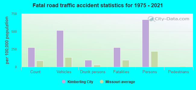
Kimberling City fatal accident list:
May 24, 2003 11:27 PM, Lakeshore, Vehicles: 1, Persons: 2, Fatalities: 1
May 19, 1997 03:50 PM, 13, Vehicles: 2, Persons: 3, Fatalities: 1
Sep 8, 1997 02:17 PM, 13, Vehicles: 2, Persons: 4, Fatalities: 1
Mar 5, 1992 02:25 PM, 13, Vehicles: 3, Persons: 3, Fatalities: 1, Drunk persons involved: 1
Jun 3, 1988 10:50 AM, 13, Vehicles: 2, Persons: 2, Fatalities: 1
- National Bridge Inventory (NBI) Statistics
- 7Number of bridges
- 236ft / 71.8mTotal length
- 43,215Total average daily traffic
- 4,204Total average daily truck traffic
2002 - 2018 National Fire Incident Reporting System (NFIRS) incidents
- Fire incident types reported to NFIRS in Kimberling City, MO
- 20755.2%Outside Fires
- 9725.9%Structure Fires
- 5614.9%Mobile Property/Vehicle Fires
- 154.0%Other
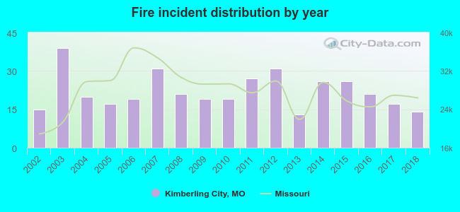 Based on the data from the years 2002 - 2018 the average number of fire incidents per year is 22. The highest number of reported fire incidents - 39 took place in 2003, and the least - 13 in 2013. The data has a declining trend.
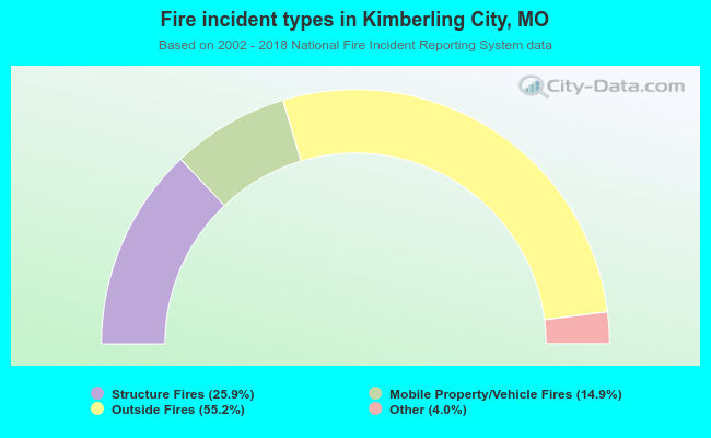 When looking into fire subcategories, the most reports belonged to: Outside Fires (55.2%), and Structure Fires (25.9%).
| Most common first names in Kimberling City, MO among deceased individuals | ||
| Name | Count | Lived (average) |
|---|---|---|
| John | 37 | 74.2 years |
| Robert | 35 | 77.2 years |
| Mary | 28 | 79.7 years |
| William | 27 | 75.0 years |
| James | 27 | 76.2 years |
| Richard | 21 | 66.7 years |
| Charles | 17 | 75.7 years |
| Helen | 17 | 85.1 years |
| George | 17 | 79.8 years |
| Joseph | 15 | 75.1 years |
| Most common last names in Kimberling City, MO among deceased individuals | ||
| Last name | Count | Lived (average) |
|---|---|---|
| Smith | 14 | 75.2 years |
| Anderson | 13 | 80.5 years |
| Brown | 10 | 78.0 years |
| Young | 9 | 80.8 years |
| Jones | 8 | 74.0 years |
| Johnson | 8 | 82.9 years |
| Miller | 8 | 77.1 years |
| Davis | 7 | 84.5 years |
| Cunningham | 6 | 69.3 years |
| Nichols | 6 | 83.0 years |
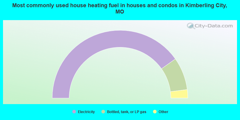
- 80.5%Electricity
- 15.6%Bottled, tank, or LP gas
- 1.7%Utility gas
- 1.6%Wood
- 0.7%Other fuel
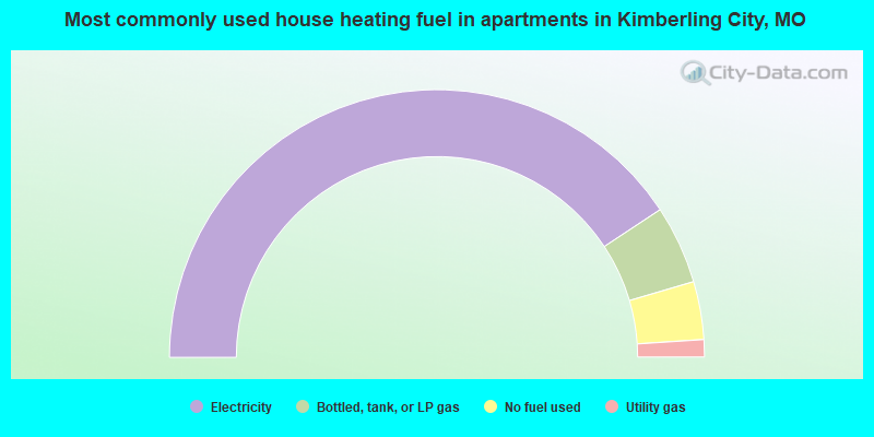
- 81.4%Electricity
- 9.5%Bottled, tank, or LP gas
- 7.0%No fuel used
- 2.1%Utility gas
Kimberling City compared to Missouri state average:
- Black race population percentage significantly below state average.
- Hispanic race population percentage significantly below state average.
- Median age significantly above state average.
- Foreign-born population percentage below state average.
- Length of stay since moving in above state average.
- House age below state average.

|
Total of 6 patent applications in 2008-2024.