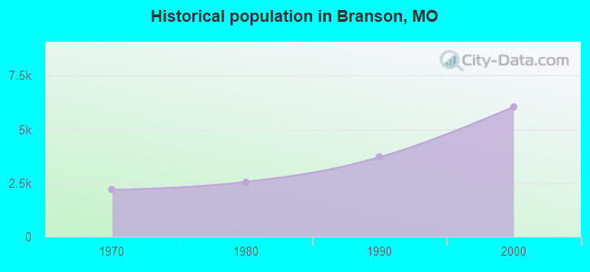
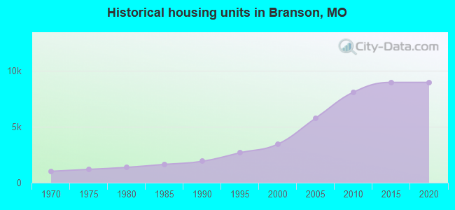
Branson, Missouri
Branson: Silver Dollar City
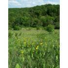
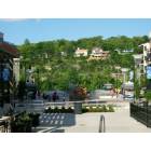
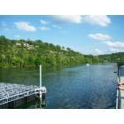
Branson: Just West of Branson
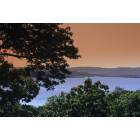
Branson: "Table Rock Lake"
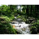
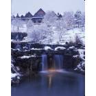
Branson: Shepherd of the Hills Fish Hatchery Release Site No.1
Branson: Branson Landing
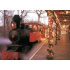
Branson: "Winter in Branson"
Branson: "Winter in Branson"
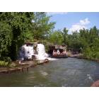
Branson: Silver Dollar City
Branson: Lake Taneycomo at Branson Landing
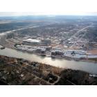
Branson: Branson Landing
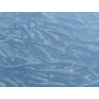
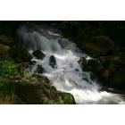
Branson: Salmon at Fish Hatchery near Branson Missouri
- see
62
more - add
your
Submit your own pictures of this city and show them to the world
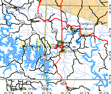
- OSM Map
- General Map
- Google Map
- MSN Map
Population change since 2000: +114.0%
| Males: 5,500 | |
| Females: 7,447 |
| Median resident age: | 41.5 years |
| Missouri median age: | 39.1 years |
| Branson: | $48,952 |
| MO: | $64,811 |
Estimated per capita income in 2022: $30,611 (it was $20,461 in 2000)
Branson city income, earnings, and wages data
Estimated median house or condo value in 2022: $223,973 (it was $111,800 in 2000)
| Branson: | $223,973 |
| MO: | $221,200 |
Median gross rent in 2022: $913.
(20.6% for White Non-Hispanic residents, 63.9% for Black residents, 54.7% for Hispanic or Latino residents, 55.9% for American Indian residents, 43.7% for other race residents, 10.3% for two or more races residents)
Detailed information about poverty and poor residents in Branson, MO


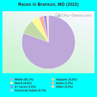
- 10,19980.3%White alone
- 1,1228.8%Hispanic
- 6124.8%Black alone
- 3873.0%Asian alone
- 2041.6%Two or more races
- 1140.9%Other race alone
- 320.3%American Indian alone
Races in Branson detailed stats: ancestries, foreign born residents, place of birth
According to our research of Missouri and other state lists, there were 84 registered sex offenders living in Branson, Missouri as of April 27, 2024.
The ratio of all residents to sex offenders in Branson is 134 to 1.
Type |
2009 |
2010 |
2011 |
2012 |
2013 |
2014 |
2015 |
2016 |
2017 |
2018 |
2019 |
2020 |
2021 |
2022 |
|---|---|---|---|---|---|---|---|---|---|---|---|---|---|---|
| Murders (per 100,000) | 0 (0.0) | 1 (9.5) | 0 (0.0) | 0 (0.0) | 2 (18.3) | 1 (9.0) | 1 (8.7) | 1 (8.6) | 0 (0.0) | 0 (0.0) | 0 (0.0) | 0 (0.0) | 2 (17.0) | 0 (0.0) |
| Rapes (per 100,000) | 1 (12.9) | 7 (66.5) | 3 (28.4) | 2 (18.6) | 6 (55.0) | 7 (62.7) | 6 (52.1) | 11 (94.9) | 12 (103.7) | 10 (86.3) | 10 (85.6) | 17 (144.7) | 23 (195.0) | 18 (138.2) |
| Robberies (per 100,000) | 9 (116.4) | 19 (180.6) | 15 (142.1) | 20 (185.9) | 22 (201.5) | 25 (223.9) | 33 (286.5) | 25 (215.6) | 15 (129.6) | 10 (86.3) | 16 (136.9) | 10 (85.1) | 6 (50.9) | 7 (53.8) |
| Assaults (per 100,000) | 102 (1,319) | 104 (988.6) | 114 (1,080) | 143 (1,329) | 130 (1,191) | 41 (367.1) | 42 (364.7) | 47 (405.4) | 54 (466.7) | 65 (560.9) | 47 (402.1) | 53 (451.3) | 36 (305.2) | 34 (261.1) |
| Burglaries (per 100,000) | 116 (1,500) | 142 (1,350) | 154 (1,459) | 149 (1,385) | 95 (870.1) | 121 (1,083) | 222 (1,928) | 155 (1,337) | 187 (1,616) | 129 (1,113) | 118 (1,010) | 111 (945.1) | 46 (389.9) | 53 (407.0) |
| Thefts (per 100,000) | 797 (10,305) | 897 (8,527) | 1,032 (9,775) | 1,103 (10,252) | 1,105 (10,121) | 1,025 (9,178) | 1,226 (10,645) | 1,145 (9,877) | 1,161 (10,034) | 999 (8,620) | 993 (8,496) | 758 (6,454) | 618 (5,239) | 698 (5,361) |
| Auto thefts (per 100,000) | 15 (193.9) | 23 (218.6) | 52 (492.5) | 45 (418.3) | 61 (558.7) | 49 (438.8) | 81 (703.3) | 88 (759.1) | 94 (812.4) | 96 (828.4) | 62 (530.5) | 65 (553.4) | 47 (398.4) | 62 (476.2) |
| Arson (per 100,000) | 1 (12.9) | 0 (0.0) | 1 (9.5) | 1 (9.3) | 3 (27.5) | 5 (44.8) | 3 (26.0) | 2 (17.3) | 3 (25.9) | 3 (25.9) | 7 (59.9) | 4 (34.1) | 1 (8.5) | 3 (23.0) |
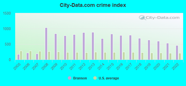
| City-Data.com crime index | 841.7 | 777.2 | 813.8 | 876.9 | 889.6 | 686.7 | 834.9 | 788.3 | 794.7 | 696.1 | 642.9 | 600.2 | 534.9 | 459.9 |
The City-Data.com crime index weighs serious crimes and violent crimes more heavily. Higher means more crime, U.S. average is 246.1. It adjusts for the number of visitors and daily workers commuting into cities.
Crime rate in Branson detailed stats: murders, rapes, robberies, assaults, burglaries, thefts, arson
Full-time law enforcement employees in 2021, including police officers: 65 (45 officers - 39 male; 6 female).
| Officers per 1,000 residents here: | 3.81 |
| Missouri average: | 2.54 |
 Recent articles from our blog. Our writers, many of them Ph.D. graduates or candidates, create easy-to-read articles on a wide variety of topics.


Latest news from Branson, MO collected exclusively by city-data.com from local newspapers, TV, and radio stations
Ancestries: German (18.4%), American (11.8%), English (11.8%), European (7.0%), Irish (6.4%), Italian (2.7%).
Current Local Time: CST time zone
Incorporated in 1912
Elevation: 722 feet
Land area: 16.2 square miles.
Population density: 800 people per square mile (low).
671 residents are foreign born (2.1% Asia, 1.8% Europe, 1.0% Latin America, 0.6% Africa).
| This city: | 5.3% |
| Missouri: | 4.2% |
Median real estate property taxes paid for housing units with mortgages in 2022: $1,504 (0.6%)
Median real estate property taxes paid for housing units with no mortgage in 2022: $1,290 (0.6%)
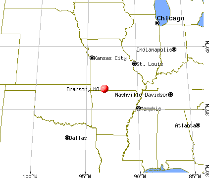
Nearest city with pop. 50,000+: Springfield, MO  (38.6 miles , pop. 151,580).
Nearest city with pop. 200,000+: Tulsa, OK (153.4 miles , pop. 393,049).
Nearest city with pop. 1,000,000+: Dallas, TX (332.8 miles , pop. 1,188,580).
Nearest cities:
), ), ), ), ), Latitude: 36.64 N, Longitude: 93.25 W
Daytime population change due to commuting: +11,634 (+91.6%)
Workers who live and work in this city: 4,362 (76.0%)
Area code: 417
Branson tourist attractions:
- The Andy Williams Moon River Theater In Branson, Missouri
- Bart Rockett Theatre - Branson MO - Magic Illusion Comedy Bart Rockett
- Branson Landing Mall - Branson MO - Mall Shopping Retail
- Celebration City Theme Park - Branson MO - Amusement Park Rides Route 66
- Chateau on the Lake Resort in Branson - Branson MO Hotel Lake Family-Friendly Convention Center
- Dixie Stampede Dinner and Show - Branson MO Dinner theater music show Dolly Parton
- Falls Village Resort - Branson MO Falls Village Resort family fun water activities
- Hamner Barber Variety Show - Branson MO Illusionist Ventriloquist Puppet Variety Show
- Hilton Branson Convention Center - Branson MO Hilton Branson Hotel Music Shopping
- Hilton Promenade at Branson Landing - Branson MO Hotel Shopping Convention Center
- Horizons by Marriott Vacation Club - Branson MO Horizons Marriott timeshare golf
- Bluegreen Wilderness Club at Big Cedar
- Pointe Royale Resort - Branson MO Pointe Royale Resort golf course luxury
- Sight & Sound Theaters in Branson - Branson MO - Christian Musical Shows
- Silver Dollar City in Branson, Missouri
- SIX in Branson, Missouri
- Still Waters Resort - Branson MO Still Water Resort Table Rock Lake hotel
- Stone Hill Winery - Branson MO - wine tasting tour vineyard
- Tribesman Resort - Branson MO Tribesman Resort family fun water activities
- White Water park in Branson - Branson MO Water Park Amusement Water Slide
- World's Largest Toy Museum
Branson, Missouri accommodation & food services, waste management - Economy and Business Data
Single-family new house construction building permits:
- 2022: 23 buildings, average cost: $131,100
- 2021: 62 buildings, average cost: $166,200
- 2020: 39 buildings, average cost: $151,800
- 2019: 46 buildings, average cost: $166,000
- 2018: 48 buildings, average cost: $169,200
- 2017: 44 buildings, average cost: $179,700
- 2016: 33 buildings, average cost: $173,000
- 2015: 29 buildings, average cost: $168,300
- 2014: 29 buildings, average cost: $199,800
- 2013: 27 buildings, average cost: $183,700
- 2012: 17 buildings, average cost: $165,300
- 2011: 21 buildings, average cost: $188,800
- 2010: 75 buildings, average cost: $88,300
- 2009: 51 buildings, average cost: $86,200
- 2008: 24 buildings, average cost: $294,600
- 2007: 39 buildings, average cost: $319,700
- 2006: 34 buildings, average cost: $196,600
- 2005: 44 buildings, average cost: $186,600
- 2004: 45 buildings, average cost: $164,500
- 2003: 57 buildings, average cost: $127,900
- 2002: 48 buildings, average cost: $113,600
- 2001: 22 buildings, average cost: $143,000
- 2000: 28 buildings, average cost: $123,200
- 1999: 29 buildings, average cost: $102,700
- 1998: 16 buildings, average cost: $90,400
- 1997: 8 buildings, average cost: $80,100
| Here: | 3.5% |
| Missouri: | 2.8% |
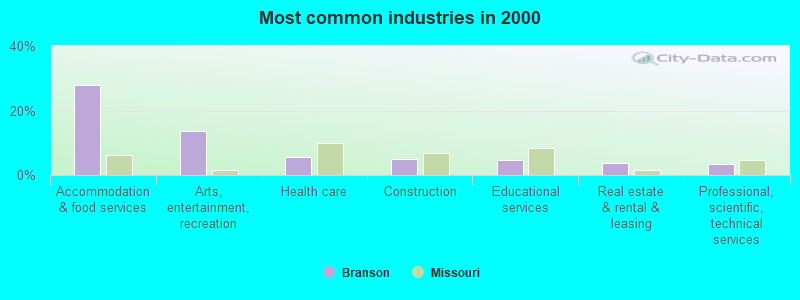
- Accommodation & food services (28.0%)
- Arts, entertainment, recreation (13.7%)
- Health care (5.4%)
- Construction (5.0%)
- Educational services (4.7%)
- Real estate & rental & leasing (3.6%)
- Professional, scientific, technical services (3.4%)
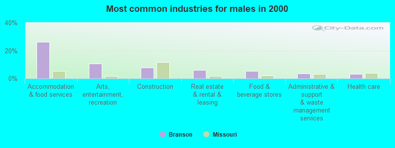
- Accommodation & food services (26.3%)
- Arts, entertainment, recreation (10.8%)
- Construction (7.9%)
- Real estate & rental & leasing (6.1%)
- Food & beverage stores (5.3%)
- Administrative & support & waste management services (3.6%)
- Health care (3.2%)

- Accommodation & food services (29.9%)
- Arts, entertainment, recreation (17.0%)
- Health care (7.9%)
- Educational services (7.0%)
- Professional, scientific, technical services (4.2%)
- Finance & insurance (3.9%)
- Used merchandise, gift, novelty, souvenir, other miscellaneous stores (3.6%)
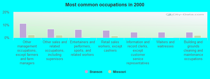
- Other management occupations, except farmers and farm managers (11.1%)
- Other sales and related occupations, including supervisors (6.7%)
- Entertainers and performers, sports, and related workers (6.4%)
- Retail sales workers, except cashiers (5.8%)
- Information and record clerks, except customer service representatives (4.4%)
- Waiters and waitresses (4.3%)
- Building and grounds cleaning and maintenance occupations (4.3%)
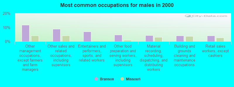
- Other management occupations, except farmers and farm managers (11.8%)
- Other sales and related occupations, including supervisors (8.9%)
- Entertainers and performers, sports, and related workers (7.0%)
- Other food preparation and serving workers, including supervisors (4.8%)
- Material recording, scheduling, dispatching, and distributing workers (4.2%)
- Building and grounds cleaning and maintenance occupations (4.1%)
- Retail sales workers, except cashiers (4.0%)
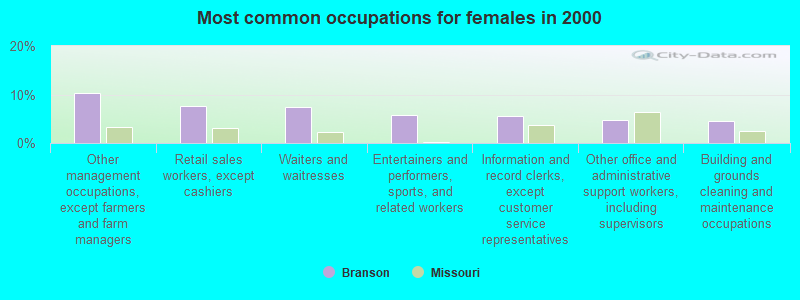
- Other management occupations, except farmers and farm managers (10.3%)
- Retail sales workers, except cashiers (7.7%)
- Waiters and waitresses (7.4%)
- Entertainers and performers, sports, and related workers (5.7%)
- Information and record clerks, except customer service representatives (5.6%)
- Other office and administrative support workers, including supervisors (4.7%)
- Building and grounds cleaning and maintenance occupations (4.5%)
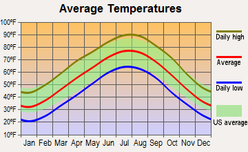
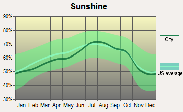
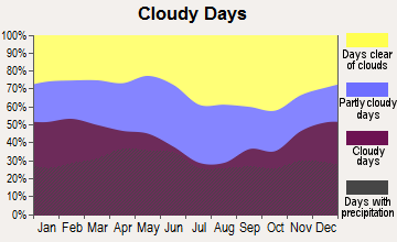
Average climate in Branson, Missouri
Based on data reported by over 4,000 weather stations
|
|

Tornado activity:
Branson-area historical tornado activity is slightly below Missouri state average. It is 42% greater than the overall U.S. average.
On 11/29/1991, a category F4 (max. wind speeds 207-260 mph) tornado 32.1 miles away from the Branson city center killed 2 people and injured 64 people and caused between $5,000,000 and $50,000,000 in damages.
On 3/24/1954, a category F3 (max. wind speeds 158-206 mph) tornado 23.7 miles away from the city center injured 2 people and caused between $5000 and $50,000 in damages.
Earthquake activity:
Branson-area historical earthquake activity is significantly above Missouri state average. It is 573% greater than the overall U.S. average.On 9/3/2016 at 12:02:44, a magnitude 5.8 (5.8 MW, Depth: 3.5 mi, Class: Moderate, Intensity: VI - VII) earthquake occurred 204.7 miles away from the city center
On 11/6/2011 at 03:53:10, a magnitude 5.7 (5.7 MW, Depth: 3.2 mi) earthquake occurred 210.6 miles away from the city center
On 2/28/2011 at 05:00:50, a magnitude 4.7 (4.7 MW, Depth: 2.0 mi, Class: Light, Intensity: IV - V) earthquake occurred 107.3 miles away from Branson center
On 5/4/2001 at 06:42:12, a magnitude 4.7 (4.2 MB, 4.7 LG, 4.5 LG) earthquake occurred 115.5 miles away from Branson center
On 3/25/1976 at 00:41:20, a magnitude 5.0 (4.9 MB, 5.0 LG) earthquake occurred 177.6 miles away from Branson center
On 1/21/1982 at 00:33:54, a magnitude 4.7 (4.5 MB, 4.7 LG, 4.5 LG) earthquake occurred 117.2 miles away from Branson center
Magnitude types: regional Lg-wave magnitude (LG), body-wave magnitude (MB), moment magnitude (MW)
Natural disasters:
The number of natural disasters in Taney County (21) is greater than the US average (15).Major Disasters (Presidential) Declared: 12
Emergencies Declared: 6
Causes of natural disasters: Storms: 14, Floods: 13, Tornadoes: 10, Winds: 5, Winter Storms: 4, Drought: 1, Hurricane: 1, Other: 1 (Note: some incidents may be assigned to more than one category).
Hospitals and medical centers in Branson:
- ACCESS HOSPICE CARE (800 HWY 248, SUITE B)
- COMMUNITY HOSPICES OF AMERICA (1756 BEE CREEK ROAD, SUITE G)
- COX MEDICAL CENTER BRANSON (Voluntary non-profit - Private, 251 SKAGGS RD, PO BOX 650)
- SKAGGS PROFESSIONAL HOSPICE (611 SOUTH SIXTH STREET)
- GOLDEN LIVINGCENTER-BRANSON (996 STATE HIGHWAY 248)
- BRANSON DIALYSIS, LLC (101 SKAGGS RD #301)
- HEALING HANDS HEALTH CARE, LLC (673 SPRING CREEK ROAD)
- SKAGGS PROFESSIONAL HOME CARE (P O BOX 650)
Airports and heliports located in Branson:
- M Graham Clark Downtown Airport (PLK) (Runways: 1, Air Taxi Ops: 400, Itinerant Ops: 6,275, Local Ops: 4,500, Military Ops: 25)
- Branson Airport (BBG) (Runways: 1, Commercial Ops: 1,343, Air Taxi Ops: 813, Itinerant Ops: 3,813, Local Ops: 58, Military Ops: 365)
- Skaggs Community Hospital Heliport (5MO0)
- Table Rock Heliport (MO38)
Colleges/universities with over 2000 students nearest to Branson:
- Missouri State University-Springfield (about 39 miles; Springfield, MO; Full-time enrollment: 16,660)
- Ozarks Technical Community College (about 41 miles; Springfield, MO; FT enrollment: 10,356)
- Drury University (about 41 miles; Springfield, MO; FT enrollment: 3,902)
- Evangel University (about 41 miles; Springfield, MO; FT enrollment: 2,036)
- NorthWest Arkansas Community College (about 55 miles; Bentonville, AR; FT enrollment: 5,634)
- Crowder College (about 63 miles; Neosho, MO; FT enrollment: 3,675)
- University of Arkansas (about 66 miles; Fayetteville, AR; FT enrollment: 22,163)
Public high school in Branson:
- BRANSON HIGH (Students: 1,101, Location: 935 BUCHANAN RD, Grades: 9-12)
Public elementary/middle schools in Branson:
- BUCHANAN INTERMEDIATE (Students: 597, Location: 766 BUCHANAN RD, Grades: 4-6)
- BRANSON JR. HIGH (Students: 561, Location: 263 BUCCANEER BLVD, Grades: 7-8)
- CEDAR RIDGE INTERMEDIATE (Students: 240, Location: 308 CEDAR RIDGE DRIVE, Grades: 4-6)
- CEDAR RIDGE ELEMENTARY (Location: 396 CEDAR RIDGE DR, Grades: 1-3)
- BUCHANAN ELEMENTARY (Location: 1000 BUCHANAN ROAD, Grades: KG-3)
Private elementary/middle school in Branson:
Points of interest:
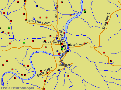
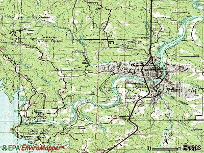
Notable locations in Branson: Branson City Campground (A), Shepherd of the Hills Fish Hatchery (B), Shepherd of the Hills State Fish Hatchery (C), Don Gardner Golf Course (D), Pointe Royale Golf Course (E), Thousand Hills Golf Course (F), Payne Stewart Front Golf Course (G), Clifford and Lavon (H), Jim Lane Cabin (I), Moonshine Beach (J), Flag (K), Branson Fire and Rescue Station 2 (L), Western Taney County Fire Protection District Station 3 (M), Branson Public Library (N), Branson Adult Community Center (O), Branson Fire and Rescue Station 3 (P), Branson Fire and Rescue Station 1 (Q). Display/hide their locations on the map
Church in Branson: Tanglewood Chapel (A). Display/hide its location on the map
Cemeteries: Lewallen Cemetery (1), Branson City Cemetery (2). Display/hide their locations on the map
Streams, rivers, and creeks: Dewey Cove (A), Roark Creek (B). Display/hide their locations on the map
Parks in Branson include: North Beach Park (1), Parnell Park (2), Eiserman Park (3), Alexander Park (4), Sunset Park (5), Epps Park (6), Mang Field (7), Cantwell Park (8), Keeter Park (9). Display/hide their locations on the map
Tourist attractions: Entertainment Concepts Inc (Museums; 3044 Shepherd Of The Hill Suite 307) (1), Antique Toy Museum (3609 W State Hwy 76) (2), American Presidential Museum (3107 West 76 Country Boulevard) (3), Downtown Branson Main Street Association (Museums; 119 West Pacific Street) (4), College of the Ozarks Clark M Graham Airport (Museums; 685 Graham Clark Drive) (5), Ozark Country Vacations (Tourism Consultants; 115 West Atlantic Street Suite 104) (6), The Ducks Ride (Water Parks & Slides; 2320 West 76 Country Boulevard) (7), 76 Mall Inn - Grand Country Inn (Water Parks & Slides; 1945 West 76 Country Boulevard) (8), Grand Country Store - Splash Country Indoors- Grand Country Inn (Water Parks & Slides; West Highway 76) (9). Display/hide their approximate locations on the map
Hotels: Holiday Inn Exp Stes Branson (1970 West Highway 76) (1), Howard Johnson Hotel Branson (3207 A West Highway 76) (2), America's Inn 4 Less (1031 West Main Street) (3), Comfort Inn Thousand Hills (203 South Wildwood Drive # A) (4), Barrington Hotel (263 Shepherd Hill Expy) (5), Good Shepherd Inn (1023 West Main Street) (6), Country Hearth Inn (1360 West 76 Country Boulevard) (7), Hillbilly Inn (1166 West 76 Country Boulevard) (8), Country Hearth Inn - Branson (1360 W 76 Country Blvd) (9). Display/hide their approximate locations on the map
Court: Branson City - Municipal Court (110 West Maddux Street) (1). Display/hide its approximate location on the map
Birthplace of: Steven Hill - College basketball player (Arkansas Razorbacks).
Drinking water stations with addresses in Branson and their reported violations in the past:
TABLE ROCK INDIAN POINT 113 (Population served: 900, Groundwater):Past monitoring violations:TABLE ROCK STATE PARK (Address: 5272 STATE HIGHWAY 165 , Population served: 500, Groundwater):
- One routine major monitoring violation
- 2 minor monitoring violations
Past monitoring violations:KANAKUK KAMP NO 2 (Population served: 450, Groundwater):
- One routine major monitoring violation
Past monitoring violations:KIDS ACROSS AMERICA (Population served: 290, Groundwater):
- One regular monitoring violation
Past monitoring violations:KANAKUK KAMP WEST (Population served: 270, Groundwater):
- One regular monitoring violation
Past monitoring violations:KANAKUK KAMP NO 7 (Population served: 260, Groundwater):
- One minor monitoring violation
- One regular monitoring violation
Past monitoring violations:TABLE ROCK CAPE FAIR PARK 124 (Population served: 240, Groundwater):
- One regular monitoring violation
Past monitoring violations:TABLE ROCK CAMPBELL PT 126 (Population served: 180, Groundwater):
- One minor monitoring violation
Past health violations:Past monitoring violations:
- MCL, Monthly (TCR) - In MAY-2008, Contaminant: Coliform. Follow-up actions: St Public Notif requested (MAY-20-2008), St Violation/Reminder Notice (MAY-20-2008), St Public Notif received (JUN-16-2008), St Compliance achieved (JAN-22-2014)
- Monitoring, Source Water (GWR) - In AUG-01-2011, Contaminant: E. COLI. Follow-up actions: St Violation/Reminder Notice (SEP-22-2011), St Public Notif requested (SEP-22-2011)
Drinking water stations with addresses in Branson that have no violations reported:
- BRANSON (Population served: 8,502, Primary Water Source Type: Surface water)
- TRIBESMAN RESORT (Population served: 358, Primary Water Source Type: Groundwater)
- INDIAN TRAILS RESORT (Address: 175 HARBOR LANE , Population served: 57, Primary Water Source Type: Groundwater)
- KAMP X TREME (Population served: 25, Primary Water Source Type: Groundwater)
- HAPPY VALLEY LODGE (Address: 867 JAKES CREEK TRAIL , Population served: 25, Primary Water Source Type: Groundwater)
- WHITE RIVER LANDING (Population served: 25, Primary Water Source Type: Groundwater)
| This city: | 2.2 people |
| Missouri: | 2.5 people |
| This city: | 57.5% |
| Whole state: | 65.3% |
| This city: | 7.8% |
| Whole state: | 6.7% |
Likely homosexual households (counted as self-reported same-sex unmarried-partner households)
- Lesbian couples: 0.3% of all households
- Gay men: 0.5% of all households
People in group quarters in Branson in 2010:
- 87 people in workers' group living quarters and job corps centers
- 62 people in nursing facilities/skilled-nursing facilities
- 39 people in emergency and transitional shelters (with sleeping facilities) for people experiencing homelessness
- 19 people in other noninstitutional facilities
- 9 people in group homes for juveniles (non-correctional)
- 2 people in local jails and other municipal confinement facilities
Banks with most branches in Branson (2011 data):
- Ozark Mountain Bank: Branson West Facility, at 400 South Commercial Street, Cedar Ridge Facility, Fall Creek Branch, Motor Bank West Branch. Info updated 2006/11/03: Bank assets: $294.9 mil, Deposits: $241.8 mil, local headquarters, positive income, Commercial Lending Specialization, 7 total offices, Holding Company: Central Bancompany
- Great Southern Bank: at 1510 State Highway 248, 1729 W Highway 76 Branch, 110 W Hensley Branch. Info updated 2012/02/03: Bank assets: $3,788.7 mil, Deposits: $2,986.3 mil, headquarters in Reeds Spring, MO, positive income, Commercial Lending Specialization, 109 total offices, Holding Company: Great Southern Bancorp, Inc.
- Regions Bank: Point Royale Center Branch, Downtown Center Branch, Branson West Rdt Branch. Info updated 2011/02/24: Bank assets: $123,368.2 mil, Deposits: $98,301.3 mil, headquarters in Birmingham, AL, positive income, Commercial Lending Specialization, 1778 total offices, Holding Company: Regions Financial Corporation
- Branson Bank: Branson Branch at 3285 Falls Parkway, branch established on 2002/08/29; at 1501 State Highway 248, branch established on 2000/03/22. Info updated 2006/11/03: Bank assets: $161.5 mil, Deposits: $134.1 mil, local headquarters, positive income, Commercial Lending Specialization, 3 total offices, Holding Company: Branson Bancshares, Inc
- First Community Bank of the Ozarks: First Community Bank Of The Ozarks - at 931 State Highway 248, branch established on 2010/01/19; First Community Bank Of The Ozarks at 121 South Commercial Street, branch established on 1993/10/01. Info updated 2006/11/03: Bank assets: $100.2 mil, Deposits: $88.0 mil, local headquarters, negative income in the last year, Commercial Lending Specialization, 4 total offices, Holding Company: M & L Holding Company
- Arvest Bank: North Gretna Branch at North Gretna Road At Highway 248b, branch established on 2007/01/03; Branson Landing Branch at 123 Branson Landing Boulevard, branch established on 2006/05/26. Info updated 2010/11/29: Bank assets: $12,520.8 mil, Deposits: $10,446.2 mil, headquarters in Fayetteville, AR, positive income, Commercial Lending Specialization, 241 total offices, Holding Company: Arvest Bank Group, Inc.
- Liberty Bank: Branson South Branch at 513 State Highway 165, branch established on 2008/10/20; Branson Branch at 1540 State Highway 248, branch established on 2005/08/22. Info updated 2011/03/28: Bank assets: $1,093.3 mil, Deposits: $919.6 mil, headquarters in Springfield, MO, positive income, Commercial Lending Specialization, 19 total offices, Holding Company: Liberty Bancshares, Inc
- Commerce Bank: Branson Financial Center Branch at 500 W Main St, branch established on 1993/05/29. Info updated 2011/07/07: Bank assets: $20,493.6 mil, Deposits: $16,805.3 mil, headquarters in Kansas City, MO, positive income, 206 total offices, Holding Company: Commerce Bancshares, Inc.
- Armed Forces Bank, National Association: Branson Wal-Mart # 73 Branch at 1101 Branson Hill S Pkway, branch established on 2008/06/11. Info updated 2010/12/16: Bank assets: $1,839.7 mil, Deposits: $1,387.5 mil, headquarters in Fort Leavenworth, KS, negative income in the last year, Commercial Lending Specialization, 78 total offices, Holding Company: Dickinson Financial Corporation Ii
- 3 other banks with 3 local branches
For population 15 years and over in Branson:
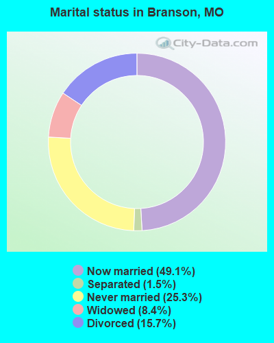
- Never married: 25.3%
- Now married: 49.1%
- Separated: 1.5%
- Widowed: 8.4%
- Divorced: 15.7%
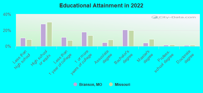
For population 25 years and over in Branson:
- High school or higher: 89.3%
- Bachelor's degree or higher: 26.8%
- Graduate or professional degree: 6.8%
- Unemployed: 8.8%
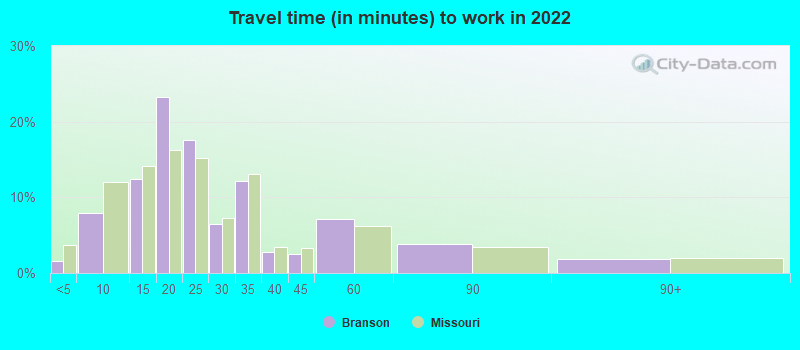
- Mean travel time to work (commute): 13.7 minutes
| Here: | 9.8 |
| Missouri average: | 11.1 |

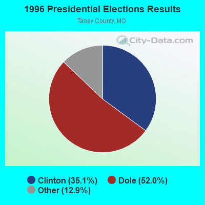
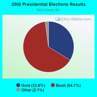
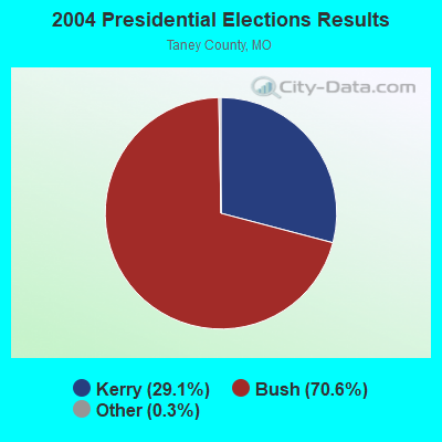

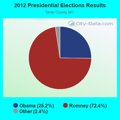
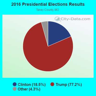
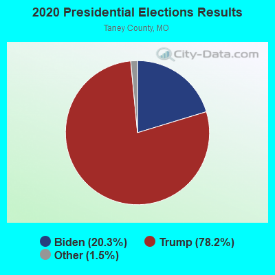
Graphs represent county-level data. Detailed 2008 Election Results
Religion statistics for Branson, MO (based on Taney County data)
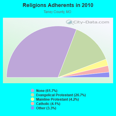
| Religion | Adherents | Congregations |
|---|---|---|
| Evangelical Protestant | 13,797 | 59 |
| Mainline Protestant | 2,161 | 10 |
| Catholic | 2,135 | 2 |
| Other | 1,689 | 10 |
| None | 31,893 | - |
Food Environment Statistics:
| Taney County: | 2.19 / 10,000 pop. |
| Missouri: | 1.88 / 10,000 pop. |
| This county: | 0.66 / 10,000 pop. |
| State: | 0.60 / 10,000 pop. |
| Taney County: | 8.10 / 10,000 pop. |
| Missouri: | 4.34 / 10,000 pop. |
| This county: | 16.42 / 10,000 pop. |
| State: | 7.37 / 10,000 pop. |
| This county: | 9.2% |
| Missouri: | 8.8% |
| This county: | 29.7% |
| State: | 29.6% |
| Here: | 12.2% |
| State: | 13.5% |
Health and Nutrition:
| This city: | 49.5% |
| Missouri: | 50.9% |
| Here: | 45.4% |
| Missouri: | 48.6% |
| Branson: | 29.0 |
| Missouri: | 28.7 |
| Branson: | 22.6% |
| State: | 20.6% |
| Branson: | 11.7% |
| Missouri: | 10.1% |
| Branson: | 6.9 |
| Missouri: | 6.8 |
| Branson: | 36.0% |
| Missouri: | 34.3% |
| This city: | 54.6% |
| Missouri: | 57.5% |
| Here: | 75.9% |
| Missouri: | 79.3% |
More about Health and Nutrition of Branson, MO Residents
| Local government employment and payroll (March 2022) | |||||
| Function | Full-time employees | Monthly full-time payroll | Average yearly full-time wage | Part-time employees | Monthly part-time payroll |
|---|---|---|---|---|---|
| Firefighters | 45 | $238,662 | $63,643 | 0 | $0 |
| Police Protection - Officers | 45 | $229,245 | $61,132 | 0 | $0 |
| Sewerage | 27 | $116,804 | $51,913 | 0 | $0 |
| Parks and Recreation | 27 | $95,075 | $42,256 | 11 | $5,250 |
| Streets and Highways | 22 | $92,896 | $50,671 | 0 | $0 |
| Other and Unallocable | 19 | $94,763 | $59,850 | 0 | $0 |
| Water Supply | 18 | $75,890 | $50,593 | 0 | $0 |
| Police - Other | 18 | $79,216 | $52,811 | 0 | $0 |
| Financial Administration | 18 | $99,169 | $66,113 | 0 | $0 |
| Other Government Administration | 15 | $106,642 | $85,314 | 0 | $0 |
| Fire - Other | 2 | $8,667 | $52,002 | 0 | $0 |
| Judicial and Legal | 2 | $9,225 | $55,350 | 0 | $0 |
| Totals for Government | 258 | $1,246,253 | $57,965 | 11 | $5,250 |
Branson government finances - Expenditure in 2021 (per resident):
- Construction - General - Other: $4,255,000 ($328.65)
Water Utilities: $977,000 ($75.46)
Sewerage: $900,000 ($69.51)
- Current Operations - General - Other: $9,794,000 ($756.47)
Central Staff Services: $6,015,000 ($464.59)
Regular Highways: $5,661,000 ($437.24)
Police Protection: $4,718,000 ($364.41)
Sewerage: $4,179,000 ($322.78)
Local Fire Protection: $3,660,000 ($282.69)
Water Utilities: $2,651,000 ($204.76)
Parks and Recreation: $2,382,000 ($183.98)
Judicial and Legal Services: $1,981,000 ($153.01)
Housing and Community Development: $1,002,000 ($77.39)
Financial Administration: $925,000 ($71.45)
- General - Interest on Debt: $9,799,000 ($756.85)
- Water Utilities - Interest on Debt: $6,000 ($0.46)
Branson government finances - Revenue in 2021 (per resident):
- Charges - Parks and Recreation: $5,874,000 ($453.70)
Sewerage: $4,905,000 ($378.85)
Other: $2,771,000 ($214.03)
- Miscellaneous - Rents: $1,441,000 ($111.30)
Interest Earnings: $836,000 ($64.57)
Fines and Forfeits: $416,000 ($32.13)
General Revenue - Other: $286,000 ($22.09)
Sale of Property: $43,000 ($3.32)
- Revenue - Water Utilities: $3,260,000 ($251.80)
- State Intergovernmental - General Local Government Support: $10,797,000 ($833.94)
Other: $52,000 ($4.02)
- Tax - General Sales and Gross Receipts: $21,113,000 ($1630.73)
Other Selective Sales: $14,685,000 ($1134.24)
Property: $3,500,000 ($270.33)
Other License: $995,000 ($76.85)
Branson government finances - Debt in 2021 (per resident):
- Long Term Debt - Beginning Outstanding - Unspecified Public Purpose: $188,505,000 ($14559.74)
Outstanding Unspecified Public Purpose: $178,871,000 ($13815.63)
Retired Unspecified Public Purpose: $9,634,000 ($744.11)
Branson government finances - Cash and Securities in 2021 (per resident):
- Bond Funds - Cash and Securities: $3,853,000 ($297.60)
- Other Funds - Cash and Securities: $79,943,000 ($6174.64)
| Businesses in Branson, MO | ||||
| Name | Count | Name | Count | |
|---|---|---|---|---|
| AT&T | 1 | Justice | 2 | |
| Aeropostale | 2 | KFC | 1 | |
| American Eagle Outfitters | 1 | Kmart | 1 | |
| Ann Taylor | 1 | Knights Inn | 1 | |
| Applebee's | 1 | Kohl's | 1 | |
| Arby's | 1 | La Quinta | 1 | |
| Banana Republic | 1 | La-Z-Boy | 1 | |
| Bath & Body Works | 2 | Lane Bryant | 2 | |
| Baymont Inn | 1 | Levi Strauss & Co. | 1 | |
| Bed Bath & Beyond | 1 | Marriott | 3 | |
| Best Western | 3 | MasterBrand Cabinets | 1 | |
| Brookstone | 1 | Maurices | 2 | |
| Budget Car Rental | 1 | McDonald's | 3 | |
| Casual Male XL | 1 | Motel 6 | 1 | |
| Charlotte Russe | 1 | Motherhood Maternity | 1 | |
| Chevrolet | 1 | New Balance | 2 | |
| Chico's | 1 | Nike | 5 | |
| Clarion | 1 | Old Navy | 1 | |
| Clarks | 1 | Olive Garden | 1 | |
| Cold Stone Creamery | 1 | Pac Sun | 2 | |
| Coldwater Creek | 1 | Panera Bread | 1 | |
| Comfort Inn | 3 | Papa John's Pizza | 1 | |
| Cracker Barrel | 1 | Payless | 1 | |
| Curves | 1 | Pizza Hut | 2 | |
| Dairy Queen | 2 | Quality | 2 | |
| Days Inn | 1 | Quiznos | 1 | |
| Deb | 1 | RadioShack | 1 | |
| Dennys | 1 | Ramada | 1 | |
| Domino's Pizza | 1 | Red Lobster | 1 | |
| DressBarn | 6 | Red Roof Inn | 1 | |
| Dressbarn | 4 | Ruby Tuesday | 1 | |
| Dunkin Donuts | 1 | Rue21 | 2 | |
| Econo Lodge | 1 | SAS Shoes | 1 | |
| Eddie Bauer | 1 | SONIC Drive-In | 1 | |
| Famous Footwear | 2 | Shoe Carnival | 1 | |
| FedEx | 9 | Skechers USA | 1 | |
| Finish Line | 1 | Sprint Nextel | 1 | |
| Ford | 1 | Staples | 1 | |
| GNC | 1 | Starbucks | 3 | |
| GameStop | 1 | Steak 'n Shake | 2 | |
| Gap | 1 | Subway | 6 | |
| Gymboree | 1 | Super 8 | 2 | |
| H&R Block | 1 | T-Mobile | 2 | |
| Hilton | 4 | T.J.Maxx | 1 | |
| Holiday Inn | 2 | Taco Bell | 2 | |
| Hollister Co. | 1 | Target | 1 | |
| Home Depot | 1 | Toys"R"Us | 1 | |
| Hot Topic | 1 | U-Haul | 2 | |
| Howard Johnson | 1 | U.S. Cellular | 1 | |
| IHOP | 1 | UPS | 7 | |
| IZOD | 2 | Vans | 1 | |
| J. Jill | 1 | Verizon Wireless | 1 | |
| Jimmy John's | 1 | Victoria's Secret | 1 | |
| JoS. A. Bank | 1 | Walgreens | 2 | |
| Jones New York | 1 | Walmart | 2 | |
| Journeys | 1 | Wendy's | 3 | |
Strongest AM radio stations in Branson:
- KOMC (1220 AM; 1 kW; BRANSON, MO; Owner: TURTLE BROADCASTING CO. OF BRANSON, L.P.)
- KWTO (560 AM; 5 kW; SPRINGFIELD, MO; Owner: KWTO, INC.)
- KTHS (1480 AM; 5 kW; BERRYVILLE, AR; Owner: KTHS/KSCC, INC.)
- KNWA (1600 AM; 5 kW; BELLEFONTE, AR; Owner: HARRISON RADIO STATIONS, INC.)
- KGHT (880 AM; 50 kW; SHERIDAN, AR; Owner: METROPOLITAN RADIO GROUP, INC.)
- KFAY (1030 AM; 10 kW; FARMINGTON, AR; Owner: CUMULUS LICENSING CORP)
- KLFJ (1550 AM; 5 kW; SPRINGFIELD, MO; Owner: 127, INC.)
- KURM (790 AM; 5 kW; ROGERS, AR; Owner: KERM, INC)
- KRMG (740 AM; 50 kW; TULSA, OK; Owner: CXR HOLDINGS, INC.)
- KSGF (1260 AM; 5 kW; SPRINGFIELD, MO; Owner: JOURNAL BROADCAST CORPORATION)
- KFAQ (1170 AM; 50 kW; TULSA, OK; Owner: JOURNAL BROADCAST CORPORATION)
- KAAY (1090 AM; 50 kW; LITTLE ROCK, AR; Owner: CITADEL BROADCASTING COMPANY)
- KBTN (1420 AM; 10 kW; NEOSHO, MO; Owner: PETRACOM OF JOPLIN, L.L.C.)
Strongest FM radio stations in Branson:
- KLFC (88.1 FM; BRANSON, MO; Owner: MOUNTAINTOP BROADCASTING, INC.)
- KSMS-FM (90.5 FM; POINT LOOKOUT, MO; Owner: SOUTHWEST MISSOURI STATE UINIVERSITY)
- KCOZ (91.7 FM; POINT LOOKOUT, MO; Owner: COLLEGE OF THE OZARKS)
- K204CN (88.7 FM; BRANSON, MO; Owner: CALVARY CHAPEL OF TWIN FALLS, INC.)
- KOZO (89.7 FM; BRANSON, MO; Owner: CREATIVE EDUCATIONAL MEDIA CORP, INC)
- KHOZ-FM (102.9 FM; HARRISON, AR; Owner: HARRISON BROADCASTING CORPORATION)
- KRZK (106.3 FM; BRANSON, MO; Owner: TURTLE BROADCASTING CO. OF BRANSON)
- KOMC-FM (100.1 FM; KIMBERLING CITY, MO; Owner: TURTLE BROADCASTING COMPANY, L.P.)
- KTXR (101.3 FM; SPRINGFIELD, MO; Owner: STEREO BROADCASTING, INC.)
- KCWD (96.1 FM; HARRISON, AR; Owner: HARRISON RADIO STATIONS, INC.)
- KTHS-FM (107.1 FM; BERRYVILLE, AR; Owner: KTHS/KSCC, INC.)
- KQMO (97.7 FM; SHELL KNOB, MO; Owner: MAGIC CIRCLE RADIO, INC.)
- KTTS-FM (94.7 FM; SPRINGFIELD, MO; Owner: JOURNAL BROADCAST CORPORATION)
- KWFC (89.1 FM; SPRINGFIELD, MO; Owner: BAPTIST BIBLE COLLEGE, INC.)
- KXUS (97.3 FM; SPRINGFIELD, MO; Owner: CLEAR CHANNEL BROADCASTING LICENSES, INC.)
- KOMG (92.9 FM; OZARK, MO; Owner: MW SPRINGMO, INC.)
- KWTO-FM (98.7 FM; SPRINGFIELD, MO; Owner: KWTO, INC.)
- KSPW (96.5 FM; SPARTA, MO; Owner: JOURNAL BROADCAST CORPORATION)
- KBPB (91.9 FM; HARRISON, MO; Owner: NEW LIFE EVANGELISTIC CENTER, INC.)
TV broadcast stations around Branson:
- K17DL (Channel 17; BRANSON, MO; Owner: KY3, INC.)
- K05JQ (Channel 5; BRANSON, MO; Owner: MILLER FAMILY BROADCASTING, L.L.C.)
- K25BD (Channel 25; BRANSON, MO; Owner: CHRISTIANS INCORPORATED FOR CHRIST)
- KWBM (Channel 31; HARRISON, AR; Owner: R.S. COMMUNICATIONS LTD. PARTNERSHIP)
- KBNS-CA (Channel 38; BRANSON, MO; Owner: THE VACATION CHANNEL, INC.)
- KYTV (Channel 3; SPRINGFIELD, MO; Owner: KY3, INC.)
- KNJD-LP (Channel 59; BRANSON, MO; Owner: NEW LIFE EVANGELISTIC CENTER, INC.)
- KOZK (Channel 21; SPRINGFIELD, MO; Owner: BD. OF GOVERNORS OF SW MISSOURI STATE UNIVERSITY)
- KSPR (Channel 33; SPRINGFIELD, MO; Owner: PIEDMONT TELEVISION OF SPRINGFIELD LICENSE LLC)
- KOLR (Channel 10; SPRINGFIELD, MO; Owner: VHR SPRINGFIELD LICENSE, INC.)
- KDEB-TV (Channel 27; SPRINGFIELD, MO; Owner: QUORUM OF MISSOURI LICENSE, LLC)
- K41FQ (Channel 41; SPRINGFIELD, MO; Owner: TRINITY BROADCASTING NETWORK)
- K54FH (Channel 54; GREEN FOREST, AR; Owner: NEW LIFE EVANGELISTIC CENTER, INC)
- National Bridge Inventory (NBI) Statistics
- 62Number of bridges
- 1,220ft / 372mTotal length
- $7,357,000Total costs
- 425,564Total average daily traffic
- 34,987Total average daily truck traffic
- New bridges - historical statistics
- 11930-1939
- 21950-1959
- 11960-1969
- 101970-1979
- 31980-1989
- 281990-1999
- 142000-2009
- 32010-2019
FCC Registered Antenna Towers: 217 (See the full list of FCC Registered Antenna Towers)
FCC Registered Commercial Land Mobile Towers: 3 (See the full list of FCC Registered Commercial Land Mobile Towers in Branson, MO)
FCC Registered Private Land Mobile Towers: 3 (See the full list of FCC Registered Private Land Mobile Towers)
FCC Registered Broadcast Land Mobile Towers: 77 (See the full list of FCC Registered Broadcast Land Mobile Towers)
FCC Registered Microwave Towers: 31 (See the full list of FCC Registered Microwave Towers in this town)
FCC Registered Paging Towers: 16 (See the full list of FCC Registered Paging Towers)
FCC Registered Maritime Coast & Aviation Ground Towers: 13 (See the full list of FCC Registered Maritime Coast & Aviation Ground Towers)
FCC Registered Amateur Radio Licenses: 171 (See the full list of FCC Registered Amateur Radio Licenses in Branson)
FAA Registered Aircraft Manufacturers and Dealers: 3 (See the full list of FAA Registered Manufacturers and Dealers in Branson)
FAA Registered Aircraft: 33 (See the full list of FAA Registered Aircraft)
2002 - 2018 National Fire Incident Reporting System (NFIRS) incidents
- Fire incident types reported to NFIRS in Branson, MO
- 88040.4%Outside Fires
- 75934.8%Structure Fires
- 41619.1%Mobile Property/Vehicle Fires
- 1245.7%Other
 According to the data from the years 2002 - 2018 the average number of fires per year is 128. The highest number of fires - 202 took place in 2011, and the least - 79 in 2003. The data has a declining trend.
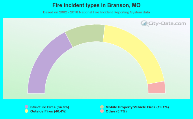 When looking into fire subcategories, the most reports belonged to: Outside Fires (40.4%), and Structure Fires (34.8%).
Fire-safe hotels and motels in Branson, Missouri:
- Best Western Knights Inn, 3215 W Hwy 76, Branson, Missouri 65616 , Phone: (417) 334-1894, Fax: (417) 334-3437
- Brighton Place, 3514 W Hwy 76, Branson, Missouri 65616 , Phone: (417) 334-5510, Fax: (417) 334-2878
- D J'S Motel, 1325 W Hwy 76, Branson, Missouri 65616 , Phone: (417) 334-0600
- Lodge Of The Ozarks, 3431 W Hwy 76, Branson, Missouri 65616 , Phone: (417) 334-7535, Fax: (417) 334-6861
- Ozark Regal Hotel, 3010 GRN MT Dr, Branson, Missouri 65616 , Phone: (417) 336-2200, Fax: (417) 336-2210
- Seven Gables Inn, 305 Hwy 165 S, Branson, Missouri 65616 , Phone: (417) 334-7077, Fax: (417) 335-3629
- Ozark Valley Inn, 2693 Shepherd Of The Hills Expy, Branson, Missouri 65616 , Phone: (800) 947-4666, Fax: (417) 336-4750
- Classic Motor Inn, 2384 Shepherd Of HLS Expwy, Branson, Missouri 65616 , Phone: (417) 334-6991
- 41 other hotels and motels
| Most common first names in Branson, MO among deceased individuals | ||
| Name | Count | Lived (average) |
|---|---|---|
| John | 112 | 74.1 years |
| James | 97 | 73.1 years |
| William | 96 | 76.2 years |
| Charles | 80 | 75.3 years |
| Mary | 79 | 77.8 years |
| Robert | 70 | 72.0 years |
| George | 50 | 77.0 years |
| Helen | 48 | 81.7 years |
| Ruth | 39 | 82.0 years |
| Edward | 34 | 81.1 years |
| Most common last names in Branson, MO among deceased individuals | ||
| Last name | Count | Lived (average) |
|---|---|---|
| Smith | 40 | 77.6 years |
| Johnson | 35 | 71.3 years |
| Miller | 27 | 75.1 years |
| Brown | 26 | 78.3 years |
| Jones | 21 | 80.0 years |
| Williams | 21 | 75.0 years |
| Harris | 19 | 78.6 years |
| Davis | 18 | 69.2 years |
| Wilson | 16 | 73.0 years |
| White | 16 | 77.1 years |
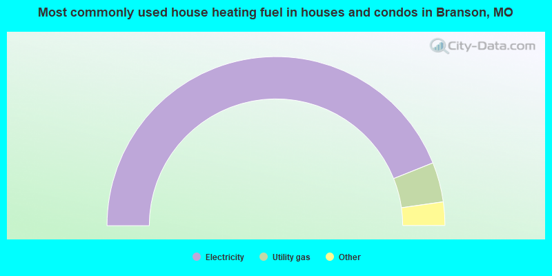
- 88.0%Electricity
- 7.6%Utility gas
- 2.5%Bottled, tank, or LP gas
- 1.2%Wood
- 0.7%No fuel used
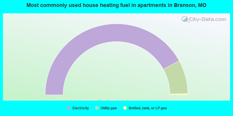
- 84.1%Electricity
- 15.4%Utility gas
- 0.5%Bottled, tank, or LP gas
Branson compared to Missouri state average:
- Hispanic race population percentage significantly above state average.
- Median age above state average.
- Foreign-born population percentage significantly above state average.
- Renting percentage above state average.
- Length of stay since moving in significantly below state average.
- Number of rooms per house below state average.
- House age significantly below state average.
Branson on our top lists:
- #4 on the list of "Top 101 cities with largest percentage of males in occupations: food preparation and serving related occupations (population 5,000+)"
- #7 on the list of "Top 101 cities with largest percentage of males in industries: accommodation and food services (population 5,000+)"
- #9 on the list of "Top 101 cities with the highest number of thefts per 100,000 residents, excludes tourist destinations and others with a lot of outsiders visiting based on city industries data (population 5,000+)"
- #24 on the list of "Top 101 cities with largest percentage of males in occupations: arts, design, entertainment, sports, and media occupations (population 5,000+)"
- #29 on the list of "Top 101 cities that people commute into (largest positive percentage daily daytime population change due to commuting) (population 5,000+)"
- #38 on the list of "Top 101 cities with the most full-time firefighters per 1000 residents (population 5,000+)"
- #38 on the list of "Top 101 cities with largest percentage of females in industries: administrative and support and waste management services (population 5,000+)"
- #40 on the list of "Top 101 cities with largest percentage of females in industries: accommodation and food services (population 5,000+)"
- #46 on the list of "Top 101 cities with the most full-time park and recreation workers per 1000 residents (population 5,000+)"
- #50 on the list of "Top 101 cities with largest percentage of females in occupations: food preparation and serving related occupations (population 5,000+)"
- #53 on the list of "Top 100 cities with strongest arts, entertainment, recreation, accommodation and food services industries"
- #54 on the list of "Top 101 cities with the highest number of assaults per 100,000 residents, excludes tourist destinations and others with a lot of outsiders visiting based on city industries data (population 5,000+)"
- #75 on the list of "Top 101 cities with the most full-time financial administration workers per 1000 residents (population 5,000+)"
- #77 on the list of "Top 101 cities with largest percentage of females in occupations: installation, maintenance, and repair occupations (population 5,000+)"
- #80 on the list of "Top 100 least-safe cities (highest city-data.com crime index)"
- #83 on the list of "Top 101 cities with largest percentage of males in industries: arts, entertainment, and recreation (population 5,000+)"
- #85 on the list of "Top 101 cities with largest percentage of females in industries: arts, entertainment, and recreation (population 5,000+)"
- #87 on the list of "Top 101 cities with the highest number of police officers per 1000 residents (population 5,000+)"
- #97 on the list of "Top 101 cities with largest percentage of males in occupations: personal care and service occupations (population 5,000+)"
- #3 (65616) on the list of "Top 101 zip codes with the most hotels or motels in 2005"
- #56 (65616) on the list of "Top 101 zip codes with the most museums in 2005"

|
|
Total of 21 patent applications in 2008-2024.