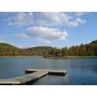
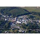
Liberty, Kentucky
Submit your own pictures of this city and show them to the world
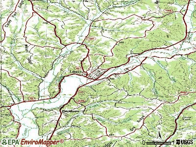
- OSM Map
- General Map
- Google Map
- MSN Map
Population change since 2000: +8.7%
 |
| Males: 862 | |
| Females: 1,149 |
| Median resident age: | 43.1 years |
| Kentucky median age: | 39.4 years |
Zip codes: 42539.
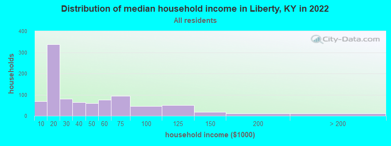
| Liberty: | $27,950 |
| KY: | $59,341 |
Estimated per capita income in 2022: $19,992 (it was $14,269 in 2000)
Liberty city income, earnings, and wages data
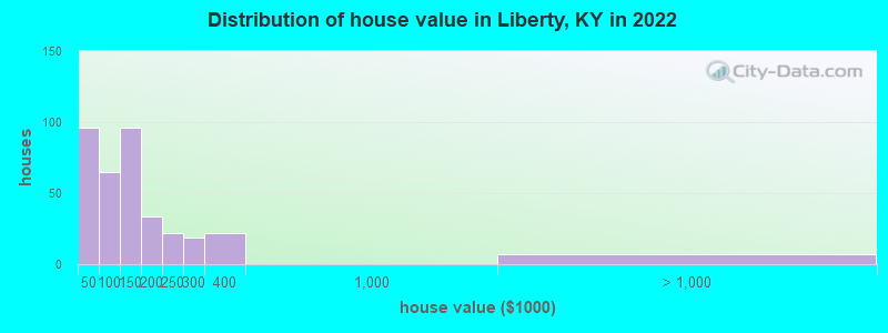
Estimated median house or condo value in 2022: $119,000 (it was $52,800 in 2000)
| Liberty: | $119,000 |
| KY: | $196,300 |
Mean prices in 2022: all housing units: $137,958; detached houses: $163,044; mobile homes: $9,391
Median gross rent in 2022: $583.
(32.9% for White Non-Hispanic residents, 5.8% for Hispanic or Latino residents, 29.6% for two or more races residents)
Detailed information about poverty and poor residents in Liberty, KY
Compare current foreclosures near Liberty, KY:
| Photo | Address | Area | Beds / Baths | Price | Details |
|---|---|---|---|---|---|

|
#1
South Kentucky 501
Liberty, KY 42539
|
2,489 sq. feet
|
2 baths 3 beds |
show details | |

|
#2
S Ky 501
Liberty, KY 42539
|
- sq. feet
|
2 baths 5 beds |
show details | |

|
#3
E Ky 70
Liberty, KY 42539
|
1,168 sq. feet
|
1 baths 2 beds |
show details | |

|
#4
W Ky 70
Liberty, KY 42539
|
1,680 sq. feet
|
3 baths 3 beds |
show details | |

|
#5
Ky 1547
Liberty, KY 42539
|
2,476 sq. feet
|
4 baths 3 beds |
show details | |

|
#6
Carmicle St
Liberty, KY 42539
|
1,128 sq. feet
|
1 baths 3 beds |
show details | |

|
#7
Lower Brush Creek Rd
Liberty, KY 42539
|
1,892 sq. feet
|
2 baths 2 beds |
show details | |

|
#8
Carmicle St
Liberty, KY 42539
|
1,016 sq. feet
|
2 baths 3 beds |
show details | |

|
#9
Margaret Ln
Liberty, KY 42539
|
- sq. feet
|
- baths - beds |
show details | |

|
#10
Moxley Rd
Liberty, KY 42539
|
- sq. feet
|
- baths - beds |
show details |
| Photo | Address | Area | Beds / Baths | Price | Details |
|---|---|---|---|---|---|

|
#11
Hamm Rd
Liberty, KY 42539
|
- sq. feet
|
- baths - beds |
show details | |

|
#12
Napier St Lot 10
Liberty, KY 42539
|
- sq. feet
|
- baths - beds |
show details | |

|
#13
Scotts Chapel Rd
Liberty, KY 42539
|
1,764 sq. feet
|
- baths - beds |
show details | |

|
#14
Shugars Hill Rd
Liberty, KY 42539
|
- sq. feet
|
- baths - beds |
show details | |

|
#15
Poplar Hill Rd
Liberty, KY 42539
|
- sq. feet
|
- baths - beds |
show details | |

|
#16
Pinewood Dr
Liberty, KY 42539
|
- sq. feet
|
- baths - beds |
show details | |

|
#17
Belden Ave
Liberty, KY 42539
|
- sq. feet
|
- baths - beds |
show details | |

|
#18
Henson Ridge Rd
Liberty, KY 42539
|
- sq. feet
|
- baths - beds |
show details | |

|
#19
Donnas Way
Liberty, KY 42539
|
- sq. feet
|
- baths - beds |
show details | |

|
#20
S Fork Ridge Rd
Liberty, KY 42539
|
- sq. feet
|
- baths - beds |
show details |
| Photo | Address | Area | Beds / Baths | Price | Details |
|---|---|---|---|---|---|

|
#21
Bryant Ridge Rd
Liberty, KY 42539
|
- sq. feet
|
- baths - beds |
show details | |

|
#22
Cornetts Cv
Liberty, KY 42539
|
- sq. feet
|
- baths - beds |
show details | |

|
#23
Neff Rd
Liberty, KY 42539
|
- sq. feet
|
- baths - beds |
show details | |

|
#24
Peyton Ridge Rd
Liberty, KY 42539
|
- sq. feet
|
- baths - beds |
show details | |

|
#25
Sheepskin Rd
Liberty, KY 42539
|
- sq. feet
|
- baths - beds |
show details | |

|
#26
Ky 49, Apt 2
Liberty, KY 42539
|
- sq. feet
|
- baths - beds |
show details | |

|
#27
A F White Rd
Columbia, KY 42728
|
1,776 sq. feet
|
1 baths 2 beds |
show details | |

|
#28
Wilson Ridge Rd
Science Hill, KY 42553
|
720 sq. feet
|
2 baths 5 beds |
show details | |

|
#29
Merrimac Rd
Bradfordsville, KY 40009
|
1,302 sq. feet
|
1 baths 3 beds |
show details | |

|
#30
Little South Rd
Gravel Switch, KY 40328
|
1,628 sq. feet
|
1 baths 3 beds |
show details |
| Photo | Address | Area | Beds / Baths | Price | Details |
|---|---|---|---|---|---|

|
#31
Brown Hollow Rd
Hustonville, KY 40437
|
1,504 sq. feet
|
1 baths 2 beds |
show details | |

|
#32
Cooper Ridge Rd
Columbia, KY 42728
|
800 sq. feet
|
1 baths 3 beds |
show details | |

|
#33
Carter School Rd
Stanford, KY 40484
|
718 sq. feet
|
- baths 2 beds |
show details | |

|
#34
Ky Highway 1247
Waynesburg, KY 40489
|
- sq. feet
|
2 baths 3 beds |
show details | |

|
#35
Damron Creek Rd
Russell Springs, KY 42642
|
- sq. feet
|
1 baths 3 beds |
show details | |

|
#36
Pleasant Point School Rd
Waynesburg, KY 40489
|
- sq. feet
|
1 baths 2 beds |
show details | |

|
#37
Jericho Rd
Russell Springs, KY 42642
|
- sq. feet
|
1 baths 3 beds |
show details | |

|
#38
Northridge Rd
Stanford, KY 40484
|
- sq. feet
|
2 baths 3 beds |
show details | |

|
#39
Raintree Dr
Stanford, KY 40484
|
- sq. feet
|
2 baths 3 beds |
show details | |

|
#40
Sunset Blvd
Hustonville, KY 40437
|
- sq. feet
|
1 baths 2 beds |
show details |
| Photo | Address | Area | Beds / Baths | Price | Details |
|---|---|---|---|---|---|

|
#41
Andy Spencer Rd
Eubank, KY 42567
|
- sq. feet
|
2 baths 3 beds |
show details | |

|
#42
Raintree Cir
Stanford, KY 40484
|
- sq. feet
|
2 baths 3 beds |
show details | |

|
#43
Ky Highway 70 W
Eubank, KY 42567
|
- sq. feet
|
2 baths 3 beds |
show details | |

|
#44
Spruce Pine Rd
Columbia, KY 42728
|
2,080 sq. feet
|
- baths - beds |
show details | |

|
#45
Stoner Creek Rd
Elk Horn, KY 42733
|
- sq. feet
|
- baths - beds |
show details | |

|
#46
Elkhorn Rd
Knifley, KY 42753
|
980 sq. feet
|
- baths - beds |
show details | |

|
#47
Dotson Dr # 8
Hustonville, KY 40437
|
- sq. feet
|
- baths - beds |
show details | |

|
#48
Highview Dr
Waynesburg, KY 40489
|
- sq. feet
|
- baths - beds |
show details | |

|
#49
A F White Rd
Columbia, KY 42728
|
1,776 sq. feet
|
- baths - beds |
show details | |

|
Check over 1 million property listings on Foreclosure.com!
|
browse all offers | |||


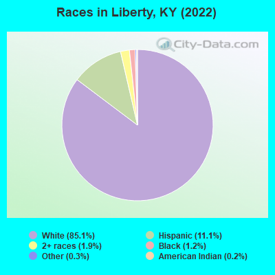
- 1,84685.1%White alone
- 24111.1%Hispanic
- 421.9%Two or more races
- 251.2%Black alone
- 60.3%Other race alone
- 50.2%American Indian alone
Races in Liberty detailed stats: ancestries, foreign born residents, place of birth
According to our research of Kentucky and other state lists, there were 25 registered sex offenders living in Liberty, Kentucky as of May 07, 2024.
The ratio of all residents to sex offenders in Liberty is 75 to 1.
Type |
2009 |
2010 |
2011 |
2012 |
2013 |
2014 |
2015 |
2016 |
2017 |
2018 |
2019 |
2020 |
2021 |
2022 |
|---|---|---|---|---|---|---|---|---|---|---|---|---|---|---|
| Murders (per 100,000) | 0 (0.0) | 0 (0.0) | 0 (0.0) | 0 (0.0) | 0 (0.0) | 0 (0.0) | 0 (0.0) | 0 (0.0) | 0 (0.0) | 0 (0.0) | 0 (0.0) | 0 (0.0) | 0 (0.0) | 0 (0.0) |
| Rapes (per 100,000) | 0 (0.0) | 0 (0.0) | 0 (0.0) | 0 (0.0) | 0 (0.0) | 0 (0.0) | 0 (0.0) | 0 (0.0) | 0 (0.0) | 0 (0.0) | 0 (0.0) | 0 (0.0) | 0 (0.0) | 0 (0.0) |
| Robberies (per 100,000) | 0 (0.0) | 1 (46.1) | 0 (0.0) | 2 (92.3) | 0 (0.0) | 0 (0.0) | 0 (0.0) | 0 (0.0) | 0 (0.0) | 0 (0.0) | 0 (0.0) | 0 (0.0) | 0 (0.0) | 0 (0.0) |
| Assaults (per 100,000) | 2 (105.4) | 2 (92.3) | 3 (137.4) | 1 (46.1) | 0 (0.0) | 1 (45.4) | 0 (0.0) | 1 (46.3) | 0 (0.0) | 1 (47.5) | 3 (142.0) | 1 (47.0) | 3 (140.4) | 0 (0.0) |
| Burglaries (per 100,000) | 6 (316.1) | 6 (276.8) | 2 (91.6) | 8 (369.0) | 3 (136.6) | 9 (408.5) | 4 (184.0) | 6 (278.0) | 1 (46.4) | 5 (237.5) | 2 (94.7) | 6 (282.2) | 0 (0.0) | 0 (0.0) |
| Thefts (per 100,000) | 7 (368.8) | 1 (46.1) | 10 (458.1) | 5 (230.6) | 18 (819.7) | 8 (363.1) | 0 (0.0) | 4 (185.4) | 1 (46.4) | 4 (190.0) | 5 (236.6) | 6 (282.2) | 2 (93.6) | 0 (0.0) |
| Auto thefts (per 100,000) | 2 (105.4) | 1 (46.1) | 3 (137.4) | 1 (46.1) | 3 (136.6) | 0 (0.0) | 2 (92.0) | 1 (46.3) | 1 (46.4) | 3 (142.5) | 1 (47.3) | 3 (141.1) | 0 (0.0) | 0 (0.0) |
| Arson (per 100,000) | 0 (0.0) | 0 (0.0) | 0 (0.0) | 0 (0.0) | 1 (45.5) | 0 (0.0) | 0 (0.0) | 0 (0.0) | 0 (0.0) | 0 (0.0) | 0 (0.0) | 0 (0.0) | 0 (0.0) | 0 (0.0) |
| City-Data.com crime index | 66.4 | 57.2 | 63.2 | 75.6 | 53.3 | 52.2 | 20.2 | 39.9 | 8.8 | 45.1 | 48.3 | 51.7 | 31.8 | 0.0 |
The City-Data.com crime index weighs serious crimes and violent crimes more heavily. Higher means more crime, U.S. average is 246.1. It adjusts for the number of visitors and daily workers commuting into cities.
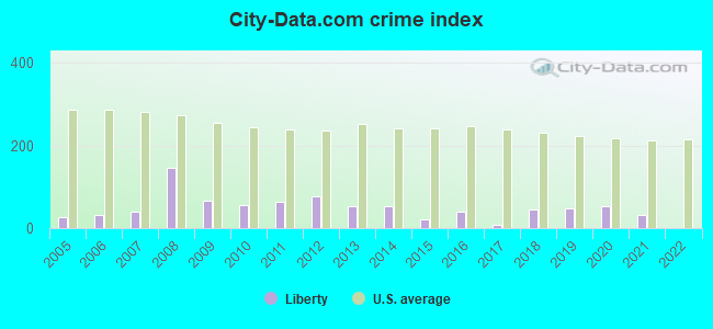
Crime rate in Liberty detailed stats: murders, rapes, robberies, assaults, burglaries, thefts, arson
Full-time law enforcement employees in 2015, including police officers: 4 (4 officers - 4 male; 0 female).
| Officers per 1,000 residents here: | 1.84 |
| Kentucky average: | 1.90 |
 Recent articles from our blog. Our writers, many of them Ph.D. graduates or candidates, create easy-to-read articles on a wide variety of topics.

 | South of Lexington? Liberty-Danville area? (2 replies) |
| West Liberty, Kentucky (2 replies) |
| Liberty, Ky scoop please (0 replies) |
| May retire near Boone National Forest (2 replies) |
| Removal of Confederate Monument – A civil conversation (55 replies) |
| Need pros and cons of retiring in Lexington, KY (30 replies) |
Latest news from Liberty, KY collected exclusively by city-data.com from local newspapers, TV, and radio stations
Ancestries: American (45.7%), English (14.7%), Irish (5.1%), Scottish (3.1%), African (2.1%), German (1.3%).
Current Local Time: EST time zone
Incorporated on 12/31/1830
Land area: 1.75 square miles.
Population density: 1,152 people per square mile (low).
71 residents are foreign born (3.2% Latin America).
| This city: | 3.3% |
| Kentucky: | 4.1% |
Median real estate property taxes paid for housing units with mortgages in 2022: $934 (0.7%)
Median real estate property taxes paid for housing units with no mortgage in 2022: $449 (0.4%)
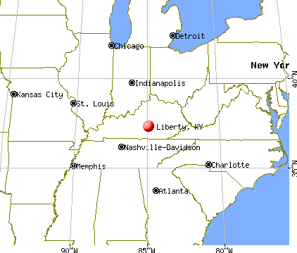
Nearest city with pop. 50,000+: Fayette, KY  (54.5 miles , pop. 260,512).
Nearest city with pop. 1,000,000+: Chicago, IL (345.2 miles , pop. 2,896,016).
Nearest cities:
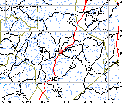
), ), ), ), Latitude: 37.32 N, Longitude: 84.93 W
Area code: 606
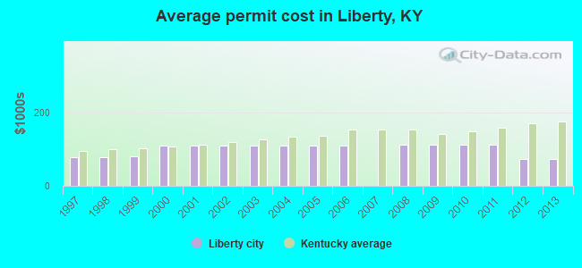
Single-family new house construction building permits:
- 2013: 1 building, cost: $74,000
- 2012: 1 building, cost: $74,000
- 2011: 1 building, cost: $112,500
- 2010: 1 building, cost: $112,500
- 2009: 1 building, cost: $112,500
- 2008: 2 buildings, average cost: $112,500
- 2006: 2 buildings, average cost: $109,300
- 2005: 2 buildings, average cost: $109,300
- 2004: 2 buildings, average cost: $109,300
- 2003: 2 buildings, average cost: $109,300
- 2002: 2 buildings, average cost: $109,300
- 2001: 2 buildings, average cost: $109,300
- 2000: 2 buildings, average cost: $109,300
- 1999: 5 buildings, average cost: $80,000
- 1998: 3 buildings, average cost: $76,700
- 1997: 3 buildings, average cost: $76,700

| Here: | 3.8% |
| Kentucky: | 3.8% |
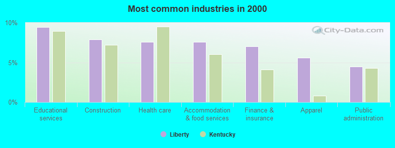
- Educational services (9.5%)
- Construction (7.9%)
- Health care (7.6%)
- Accommodation & food services (7.6%)
- Finance & insurance (7.0%)
- Apparel (5.6%)
- Public administration (4.4%)
- Construction (15.4%)
- Wood products (6.2%)
- Truck transportation (5.9%)
- Finance & insurance (5.6%)
- Educational services (5.6%)
- Agriculture, forestry, fishing & hunting (5.1%)
- Religious, grantmaking, civic, professional, similar organizations (5.1%)
- Educational services (13.5%)
- Accommodation & food services (12.6%)
- Health care (11.4%)
- Finance & insurance (8.5%)
- Apparel (6.5%)
- Department & other general merchandise stores (5.3%)
- Public administration (5.0%)
- Other management occupations, except farmers and farm managers (5.7%)
- Other production occupations, including supervisors (5.7%)
- Laborers and material movers, hand (5.5%)
- Other office and administrative support workers, including supervisors (5.3%)
- Preschool, kindergarten, elementary, and middle school teachers (4.6%)
- Building and grounds cleaning and maintenance occupations (4.0%)
- Retail sales workers, except cashiers (3.9%)
- Driver/sales workers and truck drivers (7.6%)
- Other production occupations, including supervisors (7.3%)
- Other management occupations, except farmers and farm managers (6.7%)
- Laborers and material movers, hand (6.2%)
- Other material moving workers, except laborers (5.9%)
- Religious workers (3.9%)
- Drafters, engineering, and mapping technicians (3.7%)
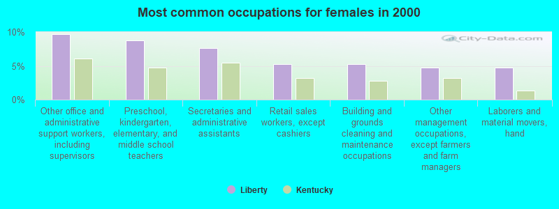
- Other office and administrative support workers, including supervisors (9.7%)
- Preschool, kindergarten, elementary, and middle school teachers (8.8%)
- Secretaries and administrative assistants (7.6%)
- Retail sales workers, except cashiers (5.3%)
- Building and grounds cleaning and maintenance occupations (5.3%)
- Other management occupations, except farmers and farm managers (4.7%)
- Laborers and material movers, hand (4.7%)
Average climate in Liberty, Kentucky
Based on data reported by over 4,000 weather stations


|
|


(lower is better)
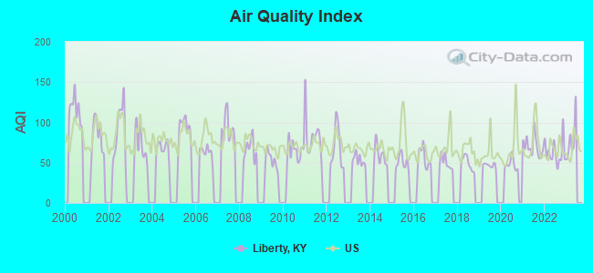
Air Quality Index (AQI) level in 2022 was 62.9. This is about average.
| City: | 62.9 |
| U.S.: | 72.6 |
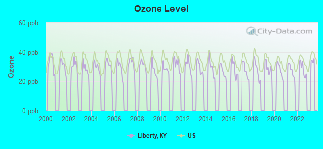
Ozone [ppb] level in 2022 was 28.6. This is about average. Closest monitor was 23.4 miles away from the city center.
| City: | 28.6 |
| U.S.: | 33.3 |
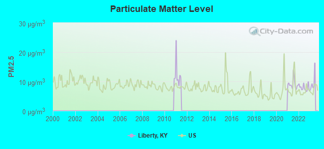
Particulate Matter (PM2.5) [µg/m3] level in 2022 was 7.87. This is about average. Closest monitor was 23.4 miles away from the city center.
| City: | 7.87 |
| U.S.: | 8.11 |
Tornado activity:
Liberty-area historical tornado activity is near Kentucky state average. It is 31% greater than the overall U.S. average.
On 4/3/1974, a category F4 (max. wind speeds 207-260 mph) tornado 13.8 miles away from the Liberty city center injured 56 people and caused between $500,000 and $5,000,000 in damages.
On 4/27/1971, a category F4 tornado 18.2 miles away from the city center killed 2 people and injured 72 people and caused between $500,000 and $5,000,000 in damages.
Earthquake activity:
Liberty-area historical earthquake activity is significantly above Kentucky state average. It is 100% greater than the overall U.S. average.On 7/27/1980 at 18:52:21, a magnitude 5.2 (5.1 MB, 4.7 MS, 5.0 UK, 5.2 UK, Class: Moderate, Intensity: VI - VII) earthquake occurred 81.6 miles away from the city center
On 4/18/2008 at 09:36:59, a magnitude 5.4 (5.1 MB, 4.8 MS, 5.4 MW, 5.2 MW) earthquake occurred 179.3 miles away from the city center
On 4/18/2008 at 09:36:59, a magnitude 5.2 (5.2 MW, Depth: 8.9 mi) earthquake occurred 179.3 miles away from the city center
On 6/18/2002 at 17:37:15, a magnitude 5.0 (4.3 MB, 4.6 MW, 5.0 LG) earthquake occurred 162.7 miles away from the city center
On 9/7/1988 at 02:28:09, a magnitude 4.6 (4.5 MB, 4.6 LG, Class: Light, Intensity: IV - V) earthquake occurred 80.9 miles away from the city center
On 6/10/1987 at 23:48:54, a magnitude 5.1 (4.9 MB, 4.4 MS, 4.6 MS, 5.1 LG) earthquake occurred 191.4 miles away from Liberty center
Magnitude types: regional Lg-wave magnitude (LG), body-wave magnitude (MB), surface-wave magnitude (MS), moment magnitude (MW)
Natural disasters:
The number of natural disasters in Casey County (23) is greater than the US average (15).Major Disasters (Presidential) Declared: 18
Emergencies Declared: 3
Causes of natural disasters: Floods: 14, Storms: 13, Tornadoes: 7, Winter Storms: 6, Mudslides: 4, Winds: 3, Landslides: 2, Blizzard: 1, Freeze: 1, Hurricane: 1, Snow: 1, Snowfall: 1, Snowstorm: 1, Other: 1 (Note: some incidents may be assigned to more than one category).
Hospitals and medical centers in Liberty:
Airports and heliports located in Liberty:
- Liberty-Casey County Airport (I53) (Runways: 1, Itinerant Ops: 300, Local Ops: 50, Military Ops: 25)
- Casey County Hospital Heliport (62LS)
Colleges/universities with over 2000 students nearest to Liberty:
- Campbellsville University (about 24 miles; Campbellsville, KY; Full-time enrollment: 2,948)
- Somerset Community College (about 25 miles; Somerset, KY; FT enrollment: 4,698)
- Lindsey Wilson College (about 26 miles; Columbia, KY; FT enrollment: 2,552)
- Eastern Kentucky University (about 46 miles; Richmond, KY; FT enrollment: 13,525)
- Bluegrass Community and Technical College (about 54 miles; Lexington, KY; FT enrollment: 8,560)
- University of Kentucky (about 55 miles; Lexington, KY; FT enrollment: 23,517)
- Elizabethtown Community and Technical College (about 58 miles; Elizabethtown, KY; FT enrollment: 3,762)
Public high school in Liberty:
- CASEY COUNTY HIGH SCHOOL (Students: 687, Location: 1841 E KY 70, Grades: 9-12)
Private high school in Liberty:
Public elementary/middle schools in Liberty:
- JONES PARK ELEMENTARY (Students: 487, Location: 6295 EAST KY 70, Grades: PK-6)
- CASEY COUNTY MIDDLE SCHOOL (Students: 411, Location: 1673 E KY 70, Grades: 7-8)
- LIBERTY ELEMENTARY SCHOOL (Location: 75 COLLEGE ST, Grades: KG-6)
- WALNUT HILL ELEMENTARY SCHOOL (Location: 2834 S US 127, Grades: PK-6)
Private elementary/middle schools in Liberty:
User-submitted facts and corrections:
- Jones Park Elementary needs to be listed in the public school section. Approximately 515 students
Points of interest:
Notable locations in Liberty: Liberty Fire Department (A), Casey County Ambulance Service (B). Display/hide their locations on the map
Cemetery: Glenwood Cemetery (1). Display/hide its location on the map
Hotel: Royal Inn Express (579 North Wallace Wilkinson Boulevard).
Courts: Casey County - Circuit Court Clerk (Court House), Kentucky Commonwealth - Court Of Justice-Jessamine- Administrative Office Of (630 Campbellsville Street).
Birthplace of: Carl Mays - Baseball player, June Ward Gayle - Politician, William N. Sweeney - Politician.
Drinking water stations with addresses in Liberty and their reported violations in the past:
EAST CASEY CO WATER DISTRICT (Population served: 12,460, Purch surface water):Past health violations:LIBERTY WATER WORKS (Population served: 2,946, Surface water):Past monitoring violations:
- MCL, Monthly (TCR) - In JUL-2005, Contaminant: Coliform. Follow-up actions: St Public Notif requested (SEP-12-2005), St Formal NOV issued (SEP-12-2005), St Compliance achieved (SEP-30-2005), St Public Notif received (DEC-14-2006)
- Monitoring and Reporting (DBP) - Between MAR-2014 and MAY-2014, Contaminant: Total Haloacetic Acids (HAA5)
- Monitoring and Reporting (DBP) - Between MAR-2014 and MAY-2014, Contaminant: TTHM
- Monitoring and Reporting (DBP) - Between DEC-2013 and FEB-2014, Contaminant: Total Haloacetic Acids (HAA5). Follow-up actions: St Formal NOV issued (MAY-01-2014), St Public Notif requested (MAY-01-2014)
- Monitoring and Reporting (DBP) - Between DEC-2013 and FEB-2014, Contaminant: TTHM. Follow-up actions: St Formal NOV issued (MAY-01-2014), St Public Notif requested (MAY-01-2014)
- Failure Submit IDSE/Subpart V Plan Rpt - In JAN-02-2010, Contaminant: DBP STAGE 2. Follow-up actions: St Public Notif requested (SEP-28-2011), St Formal NOV issued (SEP-28-2011), St Compliance achieved (JAN-30-2012), St Public Notif received (JUN-12-2013)
- One regular monitoring violation
Past health violations:Past monitoring violations:
- MCL, Average - Between JUL-2013 and SEP-2013, Contaminant: Total Haloacetic Acids (HAA5). Follow-up actions: St Public Notif requested (NOV-06-2013), St Formal NOV issued (NOV-06-2013), St Public Notif received (DEC-12-2013), St Compliance achieved (FEB-24-2014)
- MCL, Average - Between APR-2013 and JUN-2013, Contaminant: Total Haloacetic Acids (HAA5). Follow-up actions: St Public Notif requested (JUL-31-2013), St Formal NOV issued (JUL-31-2013), St Public Notif received (SEP-24-2013), St Compliance achieved (FEB-24-2014)
- MCL, Monthly (TCR) - In MAR-2006, Contaminant: Coliform. Follow-up actions: St Compliance achieved (APR-30-2006), St Public Notif requested (MAY-10-2006), St Formal NOV issued (MAY-10-2006), St Public Notif received (DEC-18-2006)
- Monitoring of Treatment (SWTR-Filter) - In JUN-2013. Follow-up actions: St Public Notif requested (AUG-15-2013), St Formal NOV issued (AUG-15-2013), St Public Notif received (SEP-24-2013), St Compliance achieved (OCT-09-2013)
- Monitoring, Turbidity (Enhanced SWTR) - In JUN-2013, Contaminant: IESWTR. Follow-up actions: St Public Notif requested (AUG-15-2013), St Formal NOV issued (AUG-15-2013), St Public Notif received (SEP-24-2013), St Compliance achieved (OCT-09-2013)
- Monitoring, Turbidity (Enhanced SWTR) - In JUN-2008, Contaminant: IESWTR. Follow-up actions: St Compliance achieved (AUG-13-2008), St Public Notif requested (AUG-23-2008), St Formal NOV issued (AUG-23-2008), St Public Notif received (APR-17-2009)
- Monthly Turbidity Exceed (Enhanced SWTR) - In FEB-2008, Contaminant: IESWTR. Follow-up actions: St Public Notif received (MAR-26-2008), St Public Notif requested (MAY-07-2008), St Formal NOV issued (MAY-07-2008), St Compliance achieved (AUG-06-2008)
- Monitoring and Reporting (DBP) - Between JUL-2006 and SEP-2006, Contaminant: CARBON, TOTAL. Follow-up actions: St Public Notif requested (NOV-14-2006), St Formal NOV issued (NOV-14-2006), St Compliance achieved (FEB-07-2007), St Public Notif received (MAY-25-2007)
- 2 minor monitoring violations
- 25 regular monitoring violations
- 3 other older monitoring violations
| This city: | 2.1 people |
| Kentucky: | 2.5 people |
| This city: | 53.7% |
| Whole state: | 66.9% |
| This city: | 6.1% |
| Whole state: | 6.4% |
Likely homosexual households (counted as self-reported same-sex unmarried-partner households)
- Lesbian couples: 0.4% of all households
- Gay men: 0.4% of all households
94 people in nursing facilities/skilled-nursing facilities in 2010
118 people in nursing homes in 2000
Banks with branches in Liberty (2011 data):
- The Casey County Bank, Inc.: at 176 Wallace Wilkinson Boulevard, branch established on 1939/12/20; Drive-In Branch at Middleburg Street, branch established on 1964/01/18. Info updated 2009/11/03: Bank assets: $160.2 mil, Deposits: $132.5 mil, local headquarters, positive income, 4 total offices, Holding Company: Casey County Bancorp, Inc.
- Farmers Deposit Bank of Middleburg, Inc.: Liberty Branch at 775 North Wallace Wilkinson Boulevard, branch established on 1996/12/09. Info updated 2010/03/26: Bank assets: $47.0 mil, Deposits: $37.8 mil, headquarters in Middleburg, KY, negative income in the last year, Commercial Lending Specialization, 2 total offices, Holding Company: John R Turner Holding Company
- The Monticello Banking Company: Casey County Branch at 611 North Wallace Wilkinson Blvd, branch established on 2006/04/26. Info updated 2010/11/02: Bank assets: $591.7 mil, Deposits: $535.7 mil, headquarters in Monticello, KY, positive income, Commercial Lending Specialization, 12 total offices, Holding Company: Monticello Bankshares, Inc.
For population 15 years and over in Liberty:
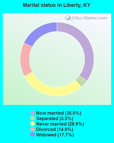
- Never married: 28.9%
- Now married: 35.0%
- Separated: 3.5%
- Widowed: 17.7%
- Divorced: 14.9%
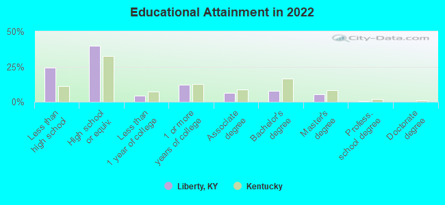
For population 25 years and over in Liberty:
- High school or higher: 74.2%
- Bachelor's degree or higher: 12.4%
- Graduate or professional degree: 5.2%
- Unemployed: 7.7%
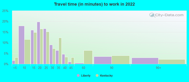
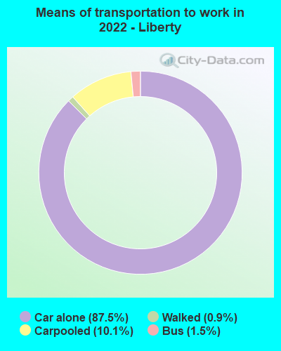
- Mean travel time to work (commute): 20.0 minutes
| Here: | 16.0 |
| Kentucky average: | 11.7 |
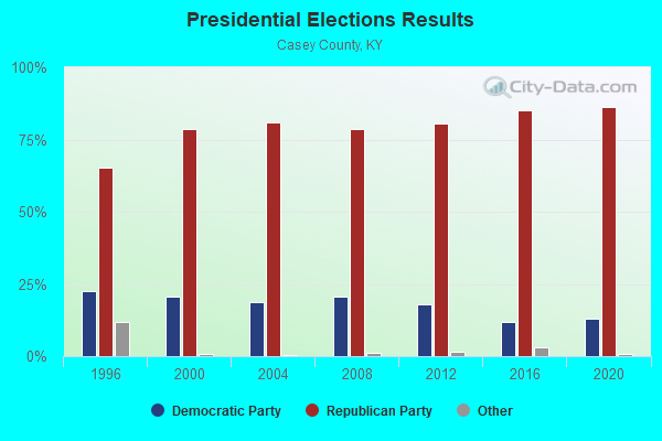
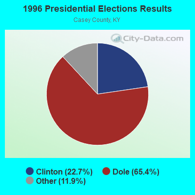
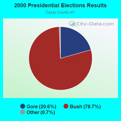
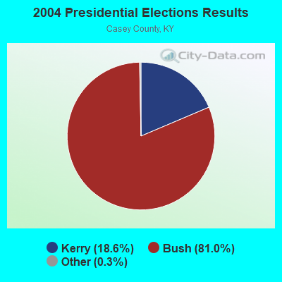
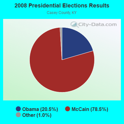
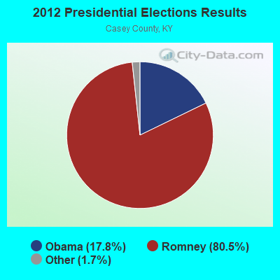
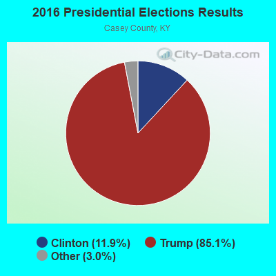

Graphs represent county-level data. Detailed 2008 Election Results
Religion statistics for Liberty, KY (based on Casey County data)
| Religion | Adherents | Congregations |
|---|---|---|
| Evangelical Protestant | 5,470 | 46 |
| Mainline Protestant | 1,554 | 13 |
| Catholic | 312 | 2 |
| Other | 2 | - |
| None | 8,617 | - |
Food Environment Statistics:
| This county: | 4.34 / 10,000 pop. |
| State: | 2.19 / 10,000 pop. |
| This county: | 2.48 / 10,000 pop. |
| Kentucky: | 0.74 / 10,000 pop. |
| This county: | 6.82 / 10,000 pop. |
| Kentucky: | 4.36 / 10,000 pop. |
| This county: | 3.72 / 10,000 pop. |
| State: | 5.74 / 10,000 pop. |
| Here: | 12.7% |
| Kentucky: | 11.0% |
| Casey County: | 31.2% |
| Kentucky: | 30.0% |
| This county: | 15.1% |
| Kentucky: | 15.9% |
Health and Nutrition:
| Here: | 51.8% |
| State: | 49.9% |
| Liberty: | 48.1% |
| State: | 47.0% |
| Liberty: | 28.4 |
| Kentucky: | 28.6 |
| This city: | 23.9% |
| State: | 21.0% |
| Liberty: | 11.6% |
| State: | 10.1% |
| This city: | 7.0 |
| Kentucky: | 6.8 |
| Liberty: | 33.8% |
| State: | 33.8% |
| Here: | 54.3% |
| Kentucky: | 56.8% |
| Liberty: | 74.8% |
| Kentucky: | 78.9% |
More about Health and Nutrition of Liberty, KY Residents
| Local government employment and payroll (March 2022) | |||||
| Function | Full-time employees | Monthly full-time payroll | Average yearly full-time wage | Part-time employees | Monthly part-time payroll |
|---|---|---|---|---|---|
| Police Protection - Officers | 5 | $19,944 | $47,866 | 4 | $1,527 |
| Gas Supply | 4 | $14,439 | $43,317 | 0 | $0 |
| Water Supply | 4 | $12,447 | $37,341 | 0 | $0 |
| Financial Administration | 3 | $12,024 | $48,096 | 0 | $0 |
| Solid Waste Management | 2 | $6,831 | $40,986 | 0 | $0 |
| Sewerage | 1 | $3,917 | $47,004 | 0 | $0 |
| Other Government Administration | 0 | $0 | 9 | $1,917 | |
| Totals for Government | 19 | $69,602 | $43,959 | 13 | $3,444 |
Liberty government finances - Expenditure in 2021 (per resident):
- Current Operations - Water Utilities: $954,000 ($474.39)
Sewerage: $801,000 ($398.31)
Gas Utilities: $654,000 ($325.21)
Police Protection: $318,000 ($158.13)
Central Staff Services: $283,000 ($140.73)
Regular Highways: $86,000 ($42.76)
Local Fire Protection: $78,000 ($38.79)
- General - Interest on Debt: $99,000 ($49.23)
- Other Capital Outlay - Local Fire Protection: $43,000 ($21.38)
Central Staff Services: $41,000 ($20.39)
- Total Salaries and Wages: $952,000 ($473.40)
- Water Utilities - Interest on Debt: $81,000 ($40.28)
Liberty government finances - Revenue in 2021 (per resident):
- Charges - Sewerage: $462,000 ($229.74)
Other: $29,000 ($14.42)
- Federal Intergovernmental - Other: $91,000 ($45.25)
- Local Intergovernmental - General Local Government Support: $75,000 ($37.29)
- Miscellaneous - Sale of Property: $61,000 ($30.33)
Interest Earnings: $30,000 ($14.92)
Fines and Forfeits: $1,000 ($0.50)
- Revenue - Water Utilities: $1,126,000 ($559.92)
Gas Utilities: $977,000 ($485.83)
- State Intergovernmental - Other: $57,000 ($28.34)
General Local Government Support: $52,000 ($25.86)
Highways: $51,000 ($25.36)
- Tax - Property: $298,000 ($148.18)
Insurance Premiums Sales: $226,000 ($112.38)
Public Utilities Sales: $150,000 ($74.59)
Other License: $1,000 ($0.50)
Liberty government finances - Debt in 2021 (per resident):
- Long Term Debt - Beginning Outstanding - Unspecified Public Purpose: $8,422,000 ($4187.97)
Outstanding Unspecified Public Purpose: $8,025,000 ($3990.55)
Retired Unspecified Public Purpose: $396,000 ($196.92)
Liberty government finances - Cash and Securities in 2021 (per resident):
- Other Funds - Cash and Securities: $2,355,000 ($1171.06)
- Sinking Funds - Cash and Securities: $214,000 ($106.41)
| Businesses in Liberty, KY | ||||
| Name | Count | Name | Count | |
|---|---|---|---|---|
| AT&T | 1 | Lane Furniture | 1 | |
| Chevrolet | 1 | McDonald's | 1 | |
| FedEx | 1 | Pizza Hut | 1 | |
| GNC | 1 | Rite Aid | 1 | |
| H&R Block | 1 | True Value | 1 | |
| La-Z-Boy | 1 | |||
Strongest AM radio stations in Liberty:
- WKDO (1560 AM; daytime; 1 kW; LIBERTY, KY; Owner: CARLOS WESLEY)
- WHAS (840 AM; 50 kW; LOUISVILLE, KY; Owner: CLEAR CHANNEL BROADCASTING LICENSES, INC.)
- WKVL (850 AM; daytime; 50 kW; KNOXVILLE, TN; Owner: HORNE RADIO, LLC)
- WSM (650 AM; 50 kW; NASHVILLE, TN; Owner: GAYLORD ENTERTAINMENT COMPANY)
- WLW (700 AM; 50 kW; CINCINNATI, OH; Owner: JACOR BROADCASTING CORPORATION)
- WAMB (1160 AM; 50 kW; DONELSON, TN; Owner: GREAT SOUTHERN BROADCASTING COMPANY, INC.)
- WIDS (570 AM; 0 kW; RUSSELL SPRINGS, KY; Owner: HAMMOND BROADCASTING, INC.)
- WKDA (1200 AM; 50 kW; NASHVILLE, TN; Owner: RADIO NASHVILLE, INC.)
- WVLK (590 AM; 5 kW; LEXINGTON, KY; Owner: CUMULUS LICENSING CORP.)
- WWAM (820 AM; daytime; 50 kW; JASPER, TN; Owner: SHELTON BROADCASTING SYSTEM)
- WSAI (1530 AM; 50 kW; CINCINNATI, OH; Owner: JACOR BROADCASTING CORPORATION)
- WDFB (1170 AM; daytime; 1 kW; JUNCTION CITY, KY; Owner: ALUM SPRINGS VISION & OUTREACH CORP)
- WNQM (1300 AM; 50 kW; NASHVILLE, TN; Owner: WNQM. INC.)
Strongest FM radio stations in Liberty:
- WKDO-FM (98.7 FM; LIBERTY, KY; Owner: CARLOS D. WESLEY)
- WXKY-FM (96.3 FM; STANFORD, KY; Owner: LINCOLN-GARRARD BROADCASTING CO.,INC)
- WDCL-FM (89.7 FM; SOMERSET, KY; Owner: WESTERN KENTUCKY UNIVERSITY)
- WSEK (97.1 FM; SOMERSET, KY; Owner: CAPSTAR TX LIMITED PARTNERSHIP)
- WVLC (99.9 FM; MANNSVILLE, KY; Owner: PATRICIA RODGERS)
- WTHL (90.5 FM; SOMERSET, KY; Owner: SOMERSET EDUCATIONAL BROADCASTING FOUNDATION)
- WDFB-FM (88.1 FM; DANVILLE, KY; Owner: ALUM SPRINGS EDUCATIONAL CORPORATION)
- WJRS (104.9 FM; JAMESTOWN, KY; Owner: LAKE CUMBERLAND BROADCASTERS)
- WCKQ (104.1 FM; CAMPBELLSVILLE, KY; Owner: CBC OF MARION & TAYLOR COUNTIES INC)
- WMKZ (93.1 FM; MONTICELLO, KY; Owner: MONTICELLO-WAYNE COUNTY MEDIA, INC.)
- WLLK (93.9 FM; BURNSIDE, KY; Owner: CAPSTAR TX LIMITED PARTNERSHIP)
- WKII-FM (102.3 FM; SOMERSET, KY; Owner: CAPSTAR TX LIMITED PARTNERSHIP)
- WHVE (92.7 FM; RUSSELL SPRINGS, KY; Owner: SHORELINE COMMUNICATIONS, INC)
- W277AA (103.3 FM; SOMERSET, KY; Owner: WESTERN KENTUCKY UNIVERSITY)
TV broadcast stations around Liberty:
- WKSO-TV (Channel 29; SOMERSET, KY; Owner: KENTUCKY AUTHORITY FOR EDUCATIONAL TV)
- WBKI-TV (Channel 34; CAMPBELLSVILLE, KY; Owner: LOUISVILLE COMMUNICATIONS, LLC)
- WDKY-TV (Channel 56; DANVILLE, KY; Owner: WDKY LICENSEE, LLC)
Liberty fatal accident list:
Feb 20, 2016 06:25 PM, Us-127, Sr-70, Lat: 37.297803, Lon: -84.950044, Vehicles: 2, Persons: 5, Fatalities: 1, Drunk persons involved: 1
Feb 15, 1996 11:10 AM, 0127, Vehicles: 1, Persons: 3, Pedestrians: 2, Fatalities: 1
Sep 13, 1995 09:37 PM, Hustonvill, Vehicles: 1, Persons: 1, Fatalities: 1, Drunk persons involved: 1
Sep 22, 1986 06:00 PM, 70, Vehicles: 1, Persons: 5, Fatalities: 1
Jun 14, 1983 12:00 PM, 127, Vehicles: 1, Persons: 1, Fatalities: 1, Drunk persons involved: 1
Jul 26, 1983 04:36 PM, 2314, Vehicles: 2, Persons: 4, Fatalities: 1, Drunk persons involved: 1
- National Bridge Inventory (NBI) Statistics
- 30Number of bridges
- 476ft / 145mTotal length
- $4,391,000Total costs
- 44,446Total average daily traffic
- 3,301Total average daily truck traffic
- 39,879Total future (year 2038) average daily traffic
- New bridges - historical statistics
- 11920-1929
- 71930-1939
- 21950-1959
- 41960-1969
- 21980-1989
- 71990-1999
- 42000-2009
- 32010-2019
FCC Registered Cell Phone Towers:
3 (See the full list of FCC Registered Cell Phone Towers in Liberty)FCC Registered Antenna Towers:
67 (See the full list of FCC Registered Antenna Towers)FCC Registered Broadcast Land Mobile Towers:
11 (See the full list of FCC Registered Broadcast Land Mobile Towers in Liberty, KY)FCC Registered Microwave Towers:
13 (See the full list of FCC Registered Microwave Towers in this town)FCC Registered Amateur Radio Licenses:
23 (See the full list of FCC Registered Amateur Radio Licenses in Liberty)FAA Registered Aircraft:
3- Aircraft: ASAP POWERED PARACHUTE (Category: Land, Seats: 2, Weight: Up to 12,499 Pounds), Engine: ROTAX 503DCSI (52 HP) (2 Cycle)
N-Number: 7513P, N7513P, N-7513P, Serial Number: 6105, Year manufactured: 2006, Airworthiness Date: 09/25/2006, Certificate Issue Date: 09/12/2014
Registrant (Individual): Mark B Strauel, Po Box 1452, Liberty, KY 42539 - Aircraft: COLEBROOK ROSS W LANCAIR 235 (Category: Land, Seats: 2, Weight: Up to 12,499 Pounds), Engine: LYCOMING 0-235 SERIES (115 HP) (Reciprocating)
N-Number: 7828, N7828, N-7828, Serial Number: 373, Year manufactured: 1995, Airworthiness Date: 12/04/2001, Certificate Issue Date: 11/20/2017
Registrant (Individual): Long Lionel, Po Box 498, Liberty, KY 42539 - Aircraft: CESSNA 150F (Category: Land, Seats: 2, Weight: Up to 12,499 Pounds, Speed: 90 mph), Engine: CONT MOTOR 0-200 SERIES (100 HP) (Reciprocating)
N-Number: 8423G, N8423G, N-8423G, Serial Number: 15062523, Year manufactured: 1965, Airworthiness Date: 12/04/1965, Certificate Issue Date: 12/26/2019
Registrant (Co-Owned): Isaiah J Strauel, Po Box 1452, Liberty, KY 42539, Other Owners: Josiah B Strauel, Mark B Strauel
2002 - 2018 National Fire Incident Reporting System (NFIRS) incidents
- Fire incident types reported to NFIRS in Liberty, KY
- 57350.4%Structure Fires
- 34430.3%Outside Fires
- 13111.5%Mobile Property/Vehicle Fires
- 887.7%Other
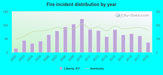 According to the data from the years 2002 - 2018 the average number of fire incidents per year is 67. The highest number of fires - 123 took place in 2010, and the least - 15 in 2002. The data has a growing trend.
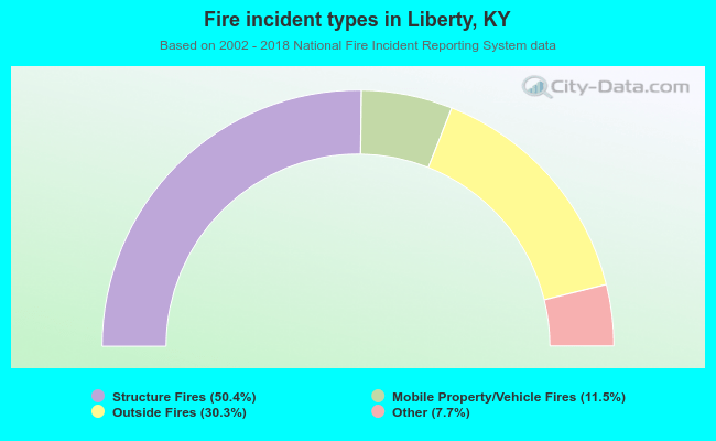 When looking into fire subcategories, the most reports belonged to: Structure Fires (50.4%), and Outside Fires (30.3%).
| Most common first names in Liberty, KY among deceased individuals | ||
| Name | Count | Lived (average) |
|---|---|---|
| James | 96 | 72.2 years |
| William | 89 | 72.7 years |
| Mary | 69 | 78.5 years |
| John | 63 | 77.6 years |
| George | 44 | 76.0 years |
| Charles | 29 | 70.8 years |
| Robert | 26 | 70.6 years |
| Thomas | 24 | 72.7 years |
| Elmer | 20 | 77.5 years |
| Ruby | 20 | 78.1 years |
| Most common last names in Liberty, KY among deceased individuals | ||
| Last name | Count | Lived (average) |
|---|---|---|
| Wethington | 74 | 69.6 years |
| Brown | 72 | 77.7 years |
| Allen | 61 | 73.9 years |
| Wilson | 50 | 69.7 years |
| Murphy | 50 | 74.1 years |
| Clements | 47 | 71.1 years |
| Atwood | 46 | 79.1 years |
| Cochran | 42 | 76.5 years |
| Wesley | 40 | 78.1 years |
| Rodgers | 32 | 74.9 years |
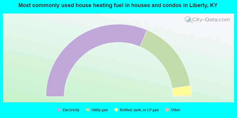
- 63.1%Electricity
- 32.4%Utility gas
- 4.5%Bottled, tank, or LP gas
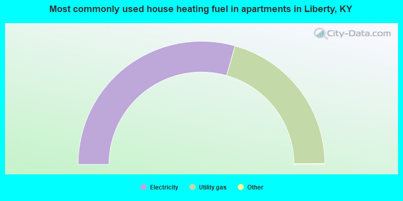
- 58.9%Electricity
- 41.1%Utility gas
Liberty compared to Kentucky state average:
- Median household income below state average.
- Median house value below state average.
- Unemployed percentage below state average.
- Black race population percentage significantly below state average.
- Hispanic race population percentage significantly above state average.
- Length of stay since moving in significantly above state average.
- Institutionalized population percentage significantly above state average.
- Percentage of population with a bachelor's degree or higher below state average.

|
Total of 1 patent application in 2008-2024.