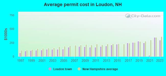
Estimated median house or condo value in 2022: $344,240 (it was $110,000 in 2000)
Loudon:
$344,240
NH:
$384,700
Mean prices in 2022:all housing units: $378,901; detached houses: $416,256; townhouses or other attached units: $317,750; in 2-unit structures: $298,869; in 3-to-4-unit structures: $371,619; in 5-or-more-unit structures: $216,601; mobile homes: $110,180; occupied boats, rvs, vans, etc.: $74,347March 2022 cost of living index in Loudon: 117.0 (more than average, U.S. average is 100)
According to our research of New Hampshire and other state lists, there were 7 registered sex offenders living in Loudon, New Hampshire as of April 26, 2024. The ratio of all residents to sex offenders in Loudon is 760 to 1. The ratio of registered sex offenders to all residents in this city is lower than the state average.
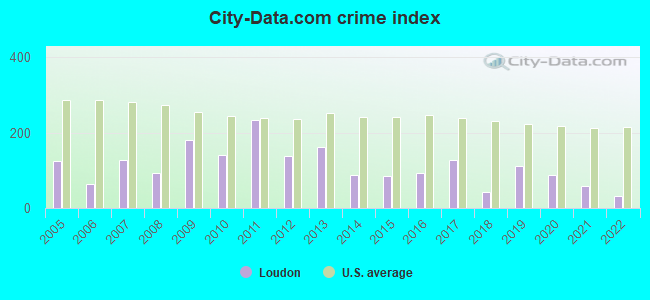
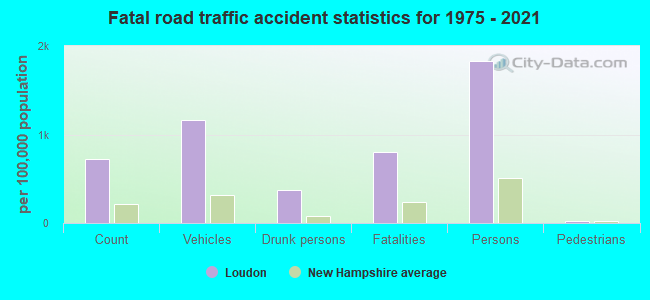
Crime rates in Loudon by year
Type
2009
2010
2011
2012
2013
2014
2015
2016
2017
2018
2019
2020
2021
2022
Murders (per 100,000)
0 (0.0)
0 (0.0)
0 (0.0)
0 (0.0)
0 (0.0)
0 (0.0)
0 (0.0)
0 (0.0)
0 (0.0)
0 (0.0)
1 (17.7)
0 (0.0)
0 (0.0)
0 (0.0)
Rapes (per 100,000)
4 (77.4)
1 (18.8)
6 (112.7)
0 (0.0)
3 (56.2)
1 (18.7)
1 (18.5)
1 (18.3)
6 (109.0)
0 (0.0)
2 (35.3)
2 (35.2)
2 (34.8)
0 (0.0)
Robberies (per 100,000)
0 (0.0)
0 (0.0)
1 (18.8)
0 (0.0)
0 (0.0)
0 (0.0)
2 (37.1)
0 (0.0)
0 (0.0)
0 (0.0)
1 (17.7)
0 (0.0)
0 (0.0)
0 (0.0)
Assaults (per 100,000)
1 (19.3)
0 (0.0)
0 (0.0)
3 (56.3)
0 (0.0)
1 (18.7)
2 (37.1)
4 (73.3)
1 (18.2)
3 (54.3)
1 (17.7)
4 (70.5)
2 (34.8)
2 (34.6)
Burglaries (per 100,000)
19 (367.6)
19 (357.3)
30 (563.5)
19 (356.3)
22 (412.2)
12 (224.3)
9 (166.9)
17 (311.6)
7 (127.1)
6 (108.6)
4 (70.7)
12 (211.5)
1 (17.4)
3 (51.9)
Thefts (per 100,000)
107 (2,070)
119 (2,238)
114 (2,141)
126 (2,363)
100 (1,874)
70 (1,309)
45 (834.7)
51 (934.9)
32 (581.2)
28 (507.0)
31 (547.7)
29 (511.0)
21 (365.9)
21 (363.3)
Auto thefts (per 100,000)
5 (96.7)
7 (131.7)
9 (169.0)
4 (75.0)
9 (168.6)
1 (18.7)
5 (92.7)
4 (73.3)
3 (54.5)
3 (54.3)
8 (141.3)
8 (141.0)
5 (87.1)
5 (86.5)
Arson (per 100,000)
0 (0.0)
0 (0.0)
1 (18.8)
1 (18.8)
2 (37.5)
0 (0.0)
0 (0.0)
0 (0.0)
1 (18.2)
0 (0.0)
0 (0.0)
0 (0.0)
1 (17.4)
0 (0.0)
City-Data.com crime index
182.1
140.1
234.4
136.7
162.3
88.2
85.9
94.4
127.3
43.1
110.6
88.8
57.7
32.0
The City-Data.com crime index weighs serious crimes and violent crimes more heavily. Higher means more crime, U.S. average is 246.1. It adjusts for the number of visitors and daily workers commuting into cities.
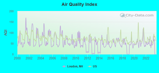
Air Quality Index (AQI) level in 2022 was 51.1. This is significantly better than average.
City:
51.1
U.S.:
72.6
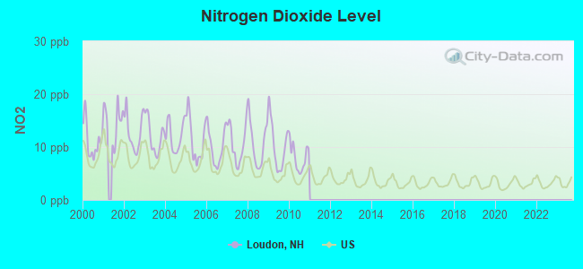
Nitrogen Dioxide (NO2) [ppb] level in 2010 was 8.02. This is significantly worse than average.Closest monitor was 9.6 miles away from the city center.
City:
8.02
U.S.:
5.11
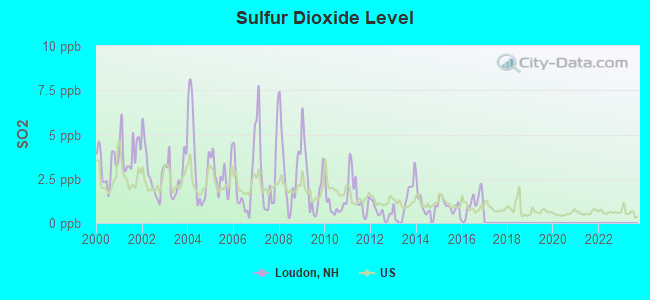
Sulfur Dioxide (SO2) [ppb] level in 2016 was 1.05. This is significantly better than average.Closest monitor was 7.5 miles away from the city center.
City:
1.05
U.S.:
1.51
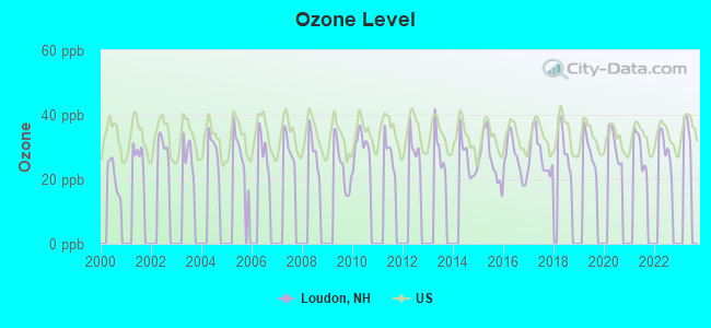
Ozone [ppb] level in 2022 was 29.4. This is about average.Closest monitor was 7.5 miles away from the city center.
City:
29.4
U.S.:
33.3
Particulate Matter (PM2.5) [µg/m3] level in 2022 was 4.52. This is significantly better than average.Closest monitor was 8.6 miles away from the city center.
City:
4.52
U.S.:
8.11
Tornado activity:
Loudon-area historical tornado activity is near New Hampshire state average. It is 50% smaller than the overall U.S. average.
On 6/9/1953, a category F3 (max. wind speeds 158-206 mph) tornado 34.3 miles away from the Loudon town center injured 5 peopleand causedbetween $5000 and $50,000 in damages.
On 7/6/1999, a category F2 (max. wind speeds 113-157 mph) tornado 6.3 miles away from the town center .
Earthquake activity:
Loudon-area historical earthquake activity is significantly above New Hampshire state average. It is 71% smaller than the overall U.S. average.
On 4/20/2002 at 10:50:47, a magnitude 5.3 (5.3 ML, Depth: 3.0 mi, Class: Moderate, Intensity: VI - VII) earthquake occurred 139.0 miles away from Loudon center On 1/19/1982 at 00:14:42, a magnitude 4.7 (4.5 MB, 4.7 MD, 4.5 LG, Class: Light, Intensity: IV - V) earthquake occurred 14.6 miles away from the city center On 10/7/1983 at 10:18:46, a magnitude 5.3 (5.1 MB, 5.3 LG, 5.1 ML) earthquake occurred 151.1 miles away from Loudon center On 4/20/2002 at 10:50:47, a magnitude 5.2 (5.2 MB, 4.2 MS, 5.2 MW, 5.0 MW) earthquake occurred 138.8 miles away from Loudon center On 10/16/2012 at 23:12:25, a magnitude 4.7 (4.7 ML, Depth: 10.0 mi) earthquake occurred 44.5 miles away from Loudon center On 8/21/1996 at 07:54:14, a magnitude 3.8 (3.8 LG, 3.6 LG, Depth: 6.2 mi, Class: Light, Intensity: II - III) earthquake occurred 60.1 miles away from the city center Magnitude types: regional Lg-wave magnitude (LG), body-wave magnitude (MB), duration magnitude (MD), local magnitude (ML), surface-wave magnitude (MS), moment magnitude (MW)
Natural disasters:
The number of natural disasters in Merrimack County (27) is a lot greater than the US average (15). Major Disasters (Presidential) Declared: 17 Emergencies Declared: 9
Causes of natural disasters: Storms: 13, Floods: 12, Winter Storms: 4, Snowstorms: 3, Hurricanes: 2, Snows: 2, Blizzard: 1, Ice Storm: 1, Snowfall: 1, Tornado: 1, Tropical Storm: 1, Wind: 1, Other: 1 (Note: some incidents may be assigned to more than one category).
Hospitals and medical centers near Loudon:
EPSOM HEALTHCARE CENTER (Nursing Home, about 7 miles away; EPSOM, NH)
HAVENWOOD-HERITAGE HEIGHTS (Nursing Home, about 8 miles away; CONCORD, NH)
NEW HAMPSHIRE HOSP-MED SURG BLDG (Hospital, about 10 miles away; CONCORD, NH)
CONCORD REGIONAL VNA (Home Health Center, about 10 miles away; CONCORD, NH)
HARRIS HILL CENTER, GENESIS HEALTHCARE (Nursing Home, about 10 miles away; CONCORD, NH)
PRESIDENTIAL OAKS (Nursing Home, about 10 miles away; CONCORD, NH)
NEW HAMPSHIRE HOSP-PSYCH UNIT (Hospital, about 10 miles away; CONCORD, NH)
Merrimack County has a predicted average indoor radon screening level between 2 and 4 pCi/L (pico curies per liter) - Moderate Potential
Drinking water stations with addresses in Loudon and their reported violations in the past:
FREEDOM HILL/PINE RIDGE EST (Population served: 375, Groundwater):
Past health violations:
MCL, Average - Between APR-2012 and JUN-2012, Contaminant: Arsenic. Follow-up actions: St Public Notif requested (JUL-06-2012), St Violation/Reminder Notice (JUL-06-2012), St Public Notif received (AUG-09-2012), St Compliance achieved (DEC-07-2012)
MCL, Acute (TCR) - In OCT-2008, Contaminant: Coliform. Follow-up actions: St Public Notif requested (OCT-28-2008), St Violation/Reminder Notice (OCT-28-2008), St Public Notif received (NOV-03-2008), St Formal NOV issued (NOV-04-2008), St Compliance achieved (MAY-08-2009)
MCL, Average - Between OCT-2008 and DEC-2008, Contaminant: Arsenic. Follow-up actions: St Public Notif requested (NOV-14-2008), St Violation/Reminder Notice (NOV-14-2008), St Public Notif received (NOV-20-2008), St Compliance achieved (JUL-17-2009)
MCL, Average - Between JUL-2008 and SEP-2008, Contaminant: Arsenic. Follow-up actions: St Public Notif requested (AUG-15-2008), St Violation/Reminder Notice (AUG-15-2008), St Public Notif received (AUG-22-2008), St Compliance achieved (JUL-17-2009)
MCL, Monthly (TCR) - In MAY-2008, Contaminant: Coliform. Follow-up actions: St Public Notif requested (JUN-02-2008), St Violation/Reminder Notice (JUN-02-2008), St Public Notif received (JUN-12-2008), St Formal NOV issued (NOV-04-2008), St Compliance achieved (MAY-06-2009)
MCL, Average - Between APR-2008 and JUN-2008, Contaminant: Arsenic. Follow-up actions: St Public Notif requested (APR-29-2008), St Violation/Reminder Notice (APR-29-2008), St Public Notif received (MAY-15-2008), St Compliance achieved (JUL-17-2009)
MCL, Average - Between APR-2007 and JUN-2007, Contaminant: Arsenic. Follow-up actions: St Public Notif requested (MAY-04-2007), St Violation/Reminder Notice (MAY-04-2007), St Public Notif received (MAY-23-2007), St Compliance achieved (FEB-15-2008)
MCL, Average - Between JAN-2007 and MAR-2007, Contaminant: Arsenic. Follow-up actions: St Public Notif requested (MAR-22-2007), St Violation/Reminder Notice (MAR-22-2007), St Public Notif received (APR-26-2007), St Compliance achieved (FEB-15-2008)
RED ROOF INN (Population served: 100, Groundwater):
Past monitoring violations:
2 routine major monitoring violations
LAZY PINES MOBILE HOME PK/UPPR (Population served: 60, Groundwater):
Past health violations:
MCL, Monthly (TCR) - In OCT-2012, Contaminant: Coliform. Follow-up actions: St Public Notif requested (OCT-23-2012), St Violation/Reminder Notice (OCT-23-2012), St Public Notif received (NOV-09-2012), St Compliance achieved (MAY-15-2013)
MCL, Average - Between JAN-2011 and MAR-2011, Contaminant: Arsenic. Follow-up actions: St Public Notif requested (APR-07-2011), St Violation/Reminder Notice (APR-07-2011), St Public Notif received (MAY-11-2011), St Compliance achieved (AUG-11-2011)
MCL, Average - Between OCT-2010 and DEC-2010, Contaminant: Arsenic. Follow-up actions: St Public Notif requested (JAN-28-2011), St Violation/Reminder Notice (JAN-28-2011), St Public Notif received (APR-08-2011), St Compliance achieved (AUG-11-2011)
MCL, Average - Between APR-2007 and JUN-2007, Contaminant: Arsenic. Follow-up actions: St Public Notif requested (MAY-25-2007), St Violation/Reminder Notice (MAY-25-2007), St Public Notif received (AUG-30-2007), St Compliance achieved (AUG-18-2008)
Past monitoring violations:
Monitoring and Reporting (DBP) - Between JUL-01-2011 and OCT-01-2011, Contaminant: Chlorine. Follow-up actions: St Violation/Reminder Notice (OCT-21-2011), St Compliance achieved (DEC-19-2011)
5 routine major monitoring violations
One minor monitoring violation
50 regular monitoring violations
LAZY PINES MOBILE HOME PK/LOWR (Population served: 51, Groundwater):
Past health violations:
OCCT/SOWT Study/Recommendation - In DEC-05-2009, Contaminant: Lead and Copper Rule. Follow-up actions: St Public Notif requested (DEC-18-2009), St Violation/Reminder Notice (DEC-18-2009), St Compliance achieved (JAN-27-2010), St Intentional no-action (JAN-27-2010)
Public Education - In AUG-15-2009, Contaminant: Lead and Copper Rule. Follow-up actions: St Violation/Reminder Notice (SEP-24-2009), St Public Notif requested (SEP-24-2009), St Formal NOV issued (NOV-05-2009), St BCA signed (NOV-12-2009), St Public Notif received (DEC-11-2009), St Compliance achieved (DEC-11-2009)
MCL, Monthly (TCR) - In NOV-2007, Contaminant: Coliform. Follow-up actions: St Public Notif requested (NOV-19-2007), St Violation/Reminder Notice (NOV-19-2007), St Formal NOV issued (NOV-20-2007), St Public Notif received (NOV-27-2007), St Compliance achieved (MAY-29-2008)
MCL, Monthly (TCR) - In OCT-2007, Contaminant: Coliform. Follow-up actions: St Public Notif requested (OCT-31-2007), St Violation/Reminder Notice (OCT-31-2007), St Public Notif received (NOV-16-2007), St Formal NOV issued (NOV-20-2007), St Compliance achieved (MAY-29-2008)
Past monitoring violations:
Water Quality Parameter M/R - In JUL-01-2009, Contaminant: Lead and Copper Rule. Follow-up actions: St Violation/Reminder Notice (SEP-24-2009), St Public Notif requested (SEP-24-2009), St Formal NOV issued (NOV-05-2009), St BCA signed (NOV-12-2009), St Compliance achieved (DEC-02-2009), St Public Notif received (DEC-11-2009)
5 routine major monitoring violations
22 regular monitoring violations
Average household size:
This town:
2.7 people
New Hampshire:
2.5 people
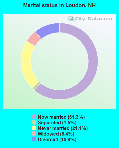
Percentage of family households:
This town:
74.2%
Whole state:
66.3%
Percentage of households with unmarried partners:
This town:
9.1%
Whole state:
8.3%
Likely homosexual households (counted as self-reported same-sex unmarried-partner households)
Lesbian couples: 0.7% of all households
Gay men: 0.4% of all households
Residents with income below the poverty level in 2009:
This town:
6.1%
Whole state:
6.5%
Residents with income below 50% of the poverty level in 2009:
This town:
3.5%
Whole state:
2.8%
2 people in other group homes in 2000
Banks with branches in Loudon (2011 data):
TD Bank, National Association: Loudon Branch at Fox Pond Plaza, branch established on 1988/12/28. Info updated 2010/10/04: Bank assets: $188,912.6 mil, Deposits: $153,149.8 mil, headquarters in Wilmington, DE, positive income, 1314 total offices, Holding Company: Toronto-Dominion Bank, The
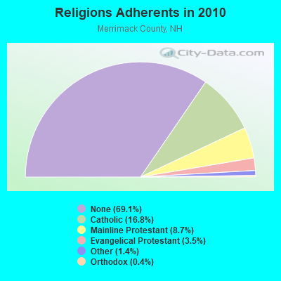
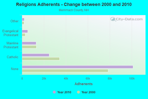
Religion statistics for Loudon, NH (based on Merrimack County data)
Religion
Adherents
Congregations
Catholic
24,654
7
Mainline Protestant
12,791
51
Evangelical Protestant
5,195
36
Other
2,097
15
Orthodox
580
2
None
101,128
-
Source: Clifford Grammich, Kirk Hadaway, Richard Houseal, Dale E.Jones, Alexei Krindatch, Richie Stanley and Richard H.Taylor. 2012. 2010 U.S.Religion Census: Religious Congregations & Membership Study. Association of Statisticians of American Religious Bodies. Jones, Dale E., et al. 2002. Congregations and Membership in the United States 2000. Nashville, TN: Glenmary Research Center. Graphs represent county-level data
Food Environment Statistics:
Number of grocery stores: 27
Merrimack County:
1.82 / 10,000 pop.
New Hampshire:
2.14 / 10,000 pop.
Number of supercenters and club stores: 2
Merrimack County:
0.14 / 10,000 pop.
New Hampshire:
0.15 / 10,000 pop.
Number of convenience stores (no gas): 18
This county:
1.22 / 10,000 pop.
State:
1.78 / 10,000 pop.
Number of convenience stores (with gas): 65
Merrimack County:
4.39 / 10,000 pop.
New Hampshire:
4.02 / 10,000 pop.
Number of full-service restaurants: 115
Merrimack County:
7.77 / 10,000 pop.
State:
9.70 / 10,000 pop.
Adult diabetes rate:
This county:
7.4%
New Hampshire:
7.6%
Adult obesity rate:
This county:
23.8%
New Hampshire:
24.4%
Low-income preschool obesity rate:
Merrimack County:
16.9%
New Hampshire:
15.9%
Businesses in Loudon, NH
Name
Count
Name
Count
Dunkin Donuts
1
Red Roof Inn
1
FedEx
1
UPS
1
Strongest AM radio stations in Loudon:
WEZS (1350 AM; 5 kW; LACONIA, NH; Owner: GARY W. HAMMOND)
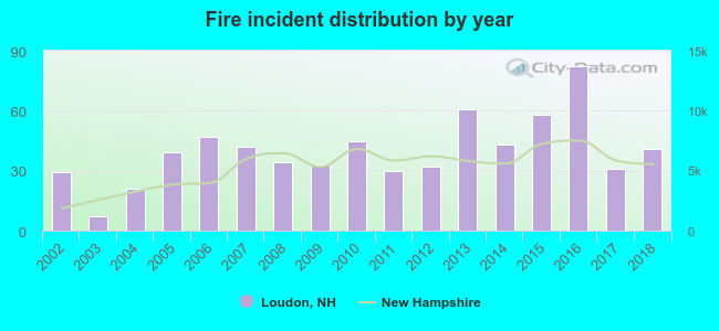
2002 - 2018 National Fire Incident Reporting System (NFIRS) incidents
According to the data from the years 2002 - 2018 the average number of fire incidents per year is 40. The highest number of reported fires - 82 took place in 2016, and the least - 7 in 2003. The data has a growing trend.
When looking into fire subcategories, the most reports belonged to: Structure Fires (56.0%), and Outside Fires (30.2%).
Fire incident types reported to NFIRS in Loudon, NH
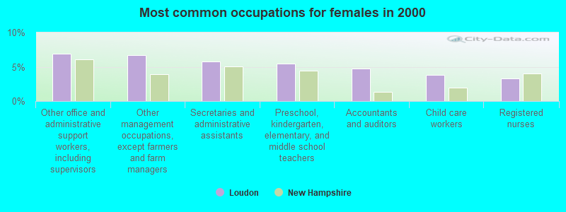
#5 on the list of "Top 101 cities with largest percentage of females in occupations: accountants and auditors (population 5,000+)"
#9 on the list of "Top 101 cities with largest percentage of males in industries: lumber and other construction materials merchant wholesalers (population 5,000+)"
#9 on the list of "Top 101 cities with largest percentage of males in industries: petroleum and petroleum products merchant wholesalers (population 5,000+)"
#20 on the list of "Top 101 cities with largest percentage of males in occupations: drafters, engineering, and mapping technicians (population 5,000+)"
#25 on the list of "Top 101 cities with largest percentage of females in industries: social assistance (population 5,000+)"
#26 on the list of "Top 101 cities with largest percentage of males in occupations: plant and system operators (population 5,000+)"
#27 on the list of "Top 101 cities with largest percentage of males in occupations: other transportation workers (population 5,000+)"
#28 on the list of "Top 101 cities with largest percentage of males in occupations: pipelayers, plumbers, pipefitters, and steamfitters (population 5,000+)"
#29 on the list of "Top 101 cities with largest percentage of females in occupations: carpenters (population 5,000+)"
#30 on the list of "Top 101 cities with largest percentage of females in industries: other transportation, and support activities, and couriers (population 5,000+)"
#36 on the list of "Top 101 cities with largest percentage of females in industries: book stores and news dealers (population 5,000+)"
#44 on the list of "Top 101 cities with largest percentage of males in industries: metals and minerals, except petroleum, merchant wholesalers (population 5,000+)"
#55 on the list of "Top 101 cities with largest percentage of males in industries: leather and allied products (population 5,000+)"
#65 on the list of "Top 101 cities with largest percentage of females in industries: paper (population 5,000+)"
#69 on the list of "Top 100 least racially diverse cities (pop. 5,000+)"
#75 on the list of "Top 101 cities with largest percentage of males in industries: religious, grantmaking, civic, professional, and similar organizations (population 5,000+)"
#77 on the list of "Top 101 cities with largest percentage of females in industries: miscellaneous nondurable goods merchant wholesalers (population 5,000+)"
#91 on the list of "Top 101 cities with the largest city-data.com crime index decrease from 2011 to 2012 (population 5,000+)"
#92 on the list of "Top 101 cities with largest percentage of females in industries: electrical and electronic goods merchant wholesalers (population 5,000+)"
#30 on the list of "Top 101 counties with the lowest number of births per 1000 residents 2007-2013"
#37 on the list of "Top 101 counties with the best general health status score of residents (1-5), 3 years of data"
#46 on the list of "Top 101 counties with the highest percentage of residents that visited a dentist within the past year"
#68 on the list of "Top 101 counties with the highest percentage of residents that keep firearms around their homes"
#73 on the list of "Top 101 counties with the lowest Sulfur Oxides Annual air pollution readings in 2012 (µg/m3)"


 Recent articles from our blog. Our writers, many of them Ph.D. graduates or candidates, create easy-to-read articles on a wide variety of topics.

 (22.9 miles


 According to the data from the years 2002 - 2018 the average number of fire incidents per year is 40. The highest number of reported fires - 82 took place in 2016, and the least - 7 in 2003. The data has a growing trend.
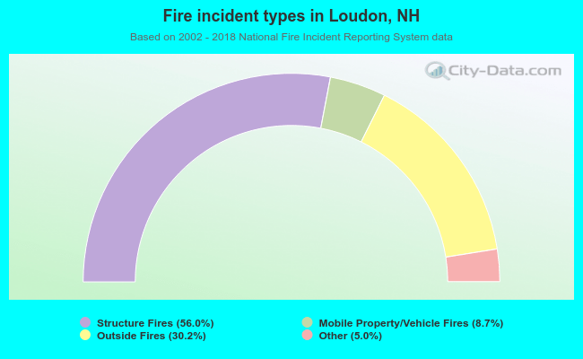 When looking into fire subcategories, the most reports belonged to: Structure Fires (56.0%), and Outside Fires (30.2%).