Lyme, New Hampshire
Submit your own pictures of this town and show them to the world
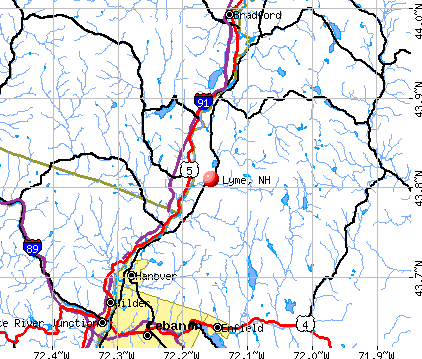
- OSM Map
- General Map
- Google Map
- MSN Map
Population change since 2000: +2.2%
 |
| Males: 838 | |
| Females: 878 |
| Median resident age: | 47.4 years |
| New Hampshire median age: | 43.9 years |
Zip codes: 03768.
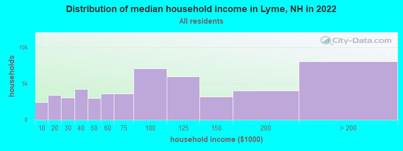
| Lyme: | $111,936 |
| NH: | $89,992 |
Estimated per capita income in 2022: $81,607 (it was $35,887 in 2000)
Lyme town income, earnings, and wages data
Estimated median house or condo value in 2022: $652,030 (it was $204,000 in 2000)
| Lyme: | $652,030 |
| NH: | $384,700 |
Mean prices in 2022: all housing units: $486,096; detached houses: $533,852; townhouses or other attached units: $375,744; in 2-unit structures: $230,260; in 3-to-4-unit structures: $242,363; in 5-or-more-unit structures: $588,257; mobile homes: $127,035
Detailed information about poverty and poor residents in Lyme, NH


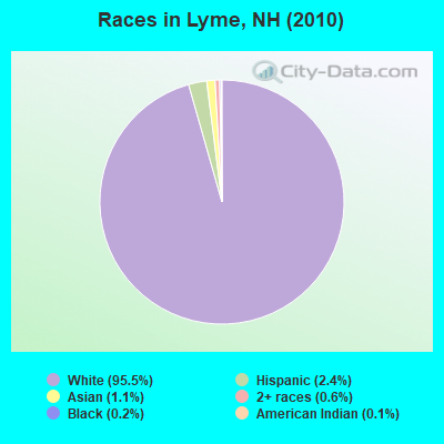
- 1,63995.5%White alone
- 412.4%Hispanic
- 191.1%Asian alone
- 110.6%Two or more races
- 40.2%Black alone
- 20.1%American Indian alone
Races in Lyme detailed stats: ancestries, foreign born residents, place of birth
According to our research of New Hampshire and other state lists, there were 2 registered sex offenders living in Lyme, New Hampshire as of April 26, 2024.
The ratio of all residents to sex offenders in Lyme is 858 to 1.
The ratio of registered sex offenders to all residents in this city is lower than the state average.
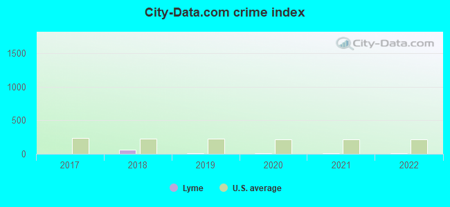
Type |
2017 |
2018 |
2019 |
2020 |
2021 |
2022 |
|---|---|---|---|---|---|---|
| Murders (per 100,000) | 0 (0.0) | 0 (0.0) | 0 (0.0) | 0 (0.0) | 0 (0.0) | 0 (0.0) |
| Rapes (per 100,000) | 0 (0.0) | 1 (60.0) | 0 (0.0) | 0 (0.0) | 0 (0.0) | 0 (0.0) |
| Robberies (per 100,000) | 0 (0.0) | 0 (0.0) | 0 (0.0) | 0 (0.0) | 0 (0.0) | 0 (0.0) |
| Assaults (per 100,000) | 0 (0.0) | 0 (0.0) | 0 (0.0) | 0 (0.0) | 0 (0.0) | 0 (0.0) |
| Burglaries (per 100,000) | 0 (0.0) | 1 (60.0) | 1 (59.7) | 1 (59.8) | 0 (0.0) | 0 (0.0) |
| Thefts (per 100,000) | 2 (119.7) | 0 (0.0) | 2 (119.4) | 4 (239.4) | 3 (178.4) | 3 (170.6) |
| Auto thefts (per 100,000) | 0 (0.0) | 2 (119.9) | 0 (0.0) | 0 (0.0) | 0 (0.0) | 0 (0.0) |
| Arson (per 100,000) | 0 (0.0) | 0 (0.0) | 0 (0.0) | 0 (0.0) | 0 (0.0) | 0 (0.0) |
| City-Data.com crime index | 4.8 | 61.8 | 9.0 | 13.8 | 7.1 | 6.8 |
The City-Data.com crime index weighs serious crimes and violent crimes more heavily. Higher means more crime, U.S. average is 246.1. It adjusts for the number of visitors and daily workers commuting into cities.
Crime rate in Lyme detailed stats: murders, rapes, robberies, assaults, burglaries, thefts, arson
Full-time law enforcement employees in 2021, including police officers: 2 (2 officers - 2 male; 0 female).
| Officers per 1,000 residents here: | 1.19 |
| New Hampshire average: | 2.14 |
 Recent articles from our blog. Our writers, many of them Ph.D. graduates or candidates, create easy-to-read articles on a wide variety of topics.

 | Lyme Disease help (9 replies) |
| What are the chances NH implements an income or sales tax in the next decade? (120 replies) |
| Relocation suggestions (30 replies) |
| Lyme Disease for Newbies (22 replies) |
| First visit to NH (28 replies) |
| AP Article: After an absence, New England’s ticks are back — and hungry (1 reply) |
Latest news from Lyme, NH collected exclusively by city-data.com from local newspapers, TV, and radio stations
Ancestries: English (29.3%), Irish (17.6%), German (14.9%), United States (7.9%), French (6.6%), Scottish (5.9%).
Current Local Time: EST time zone
Incorporated in 1761
Elevation: 563 feet
Land area: 53.8 square miles.
Population density: 32 people per square mile (very low).
43 residents are foreign born (1.3% Europe, 0.8% Asia, 0.4% North America).
| This town: | 2.6% |
| New Hampshire: | 4.4% |
| Lyme town: | 1.7% ($3,446) |
| New Hampshire: | 2.3% ($2,946) |
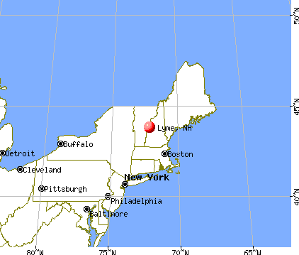
Nearest city with pop. 50,000+: Manchester, NH  (66.2 miles , pop. 107,006).
Nearest city with pop. 200,000+: Boston, MA (115.4 miles , pop. 589,141).
Nearest city with pop. 1,000,000+: Bronx, NY (222.9 miles , pop. 1,332,650).
Nearest cities:
), ), ), ), )Latitude: 43.80 N, Longitude: 72.14 W
Area code: 603

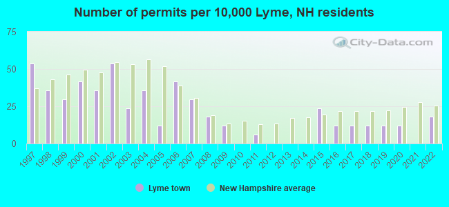
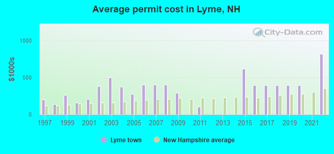
Single-family new house construction building permits:
- 2022: 3 buildings, average cost: $820,000
- 2020: 2 buildings, average cost: $397,200
- 2019: 2 buildings, average cost: $397,200
- 2018: 2 buildings, average cost: $397,200
- 2017: 2 buildings, average cost: $397,200
- 2016: 2 buildings, average cost: $397,200
- 2015: 4 buildings, average cost: $618,900
- 2011: 1 building, cost: $105,000
- 2009: 2 buildings, average cost: $288,500
- 2008: 3 buildings, average cost: $400,100
- 2007: 5 buildings, average cost: $400,100
- 2006: 7 buildings, average cost: $400,100
- 2005: 2 buildings, average cost: $275,000
- 2004: 6 buildings, average cost: $374,700
- 2003: 4 buildings, average cost: $497,300
- 2002: 9 buildings, average cost: $378,500
- 2001: 6 buildings, average cost: $207,500
- 2000: 7 buildings, average cost: $156,900
- 1999: 5 buildings, average cost: $263,600
- 1998: 6 buildings, average cost: $138,300
- 1997: 9 buildings, average cost: $202,400
| Here: | 2.1% |
| New Hampshire: | 2.5% |
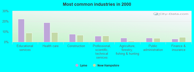
- Educational services (22.4%)
- Health care (18.9%)
- Construction (7.7%)
- Professional, scientific, technical services (5.9%)
- Agriculture, forestry, fishing & hunting (4.0%)
- Public administration (3.9%)
- Finance & insurance (3.1%)
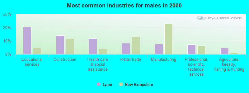
- Educational services (20.8%)
- Construction (14.2%)
- Health care (11.5%)
- Professional, scientific, technical services (7.5%)
- Agriculture, forestry, fishing & hunting (4.6%)
- Public administration (4.6%)
- Finance & insurance (3.8%)
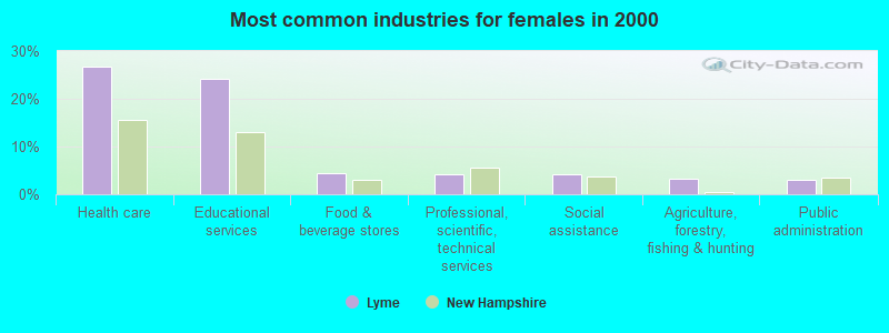
- Health care (26.6%)
- Educational services (24.1%)
- Food & beverage stores (4.4%)
- Professional, scientific, technical services (4.2%)
- Social assistance (4.2%)
- Agriculture, forestry, fishing & hunting (3.3%)
- Public administration (3.0%)
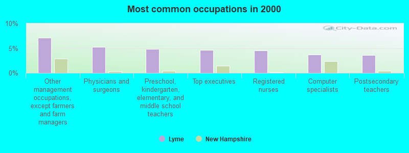
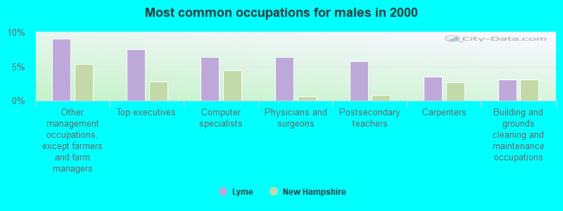
- Other management occupations, except farmers and farm managers (7.2%)
- Physicians and surgeons (5.2%)
- Preschool, kindergarten, elementary, and middle school teachers (4.9%)
- Top executives (4.7%)
- Registered nurses (4.5%)
- Computer specialists (3.8%)
- Postsecondary teachers (3.6%)
- Other management occupations, except farmers and farm managers (9.1%)
- Top executives (7.5%)
- Computer specialists (6.4%)
- Physicians and surgeons (6.4%)
- Postsecondary teachers (5.8%)
- Carpenters (3.5%)
- Building and grounds cleaning and maintenance occupations (3.1%)
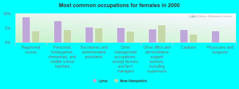
- Registered nurses (8.9%)
- Preschool, kindergarten, elementary, and middle school teachers (7.5%)
- Secretaries and administrative assistants (5.4%)
- Other management occupations, except farmers and farm managers (5.1%)
- Other office and administrative support workers, including supervisors (4.7%)
- Cashiers (4.4%)
- Physicians and surgeons (4.0%)
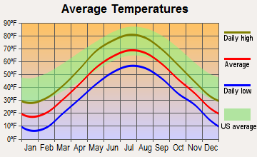
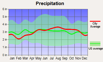
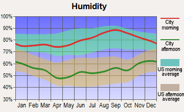
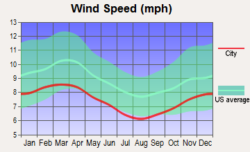
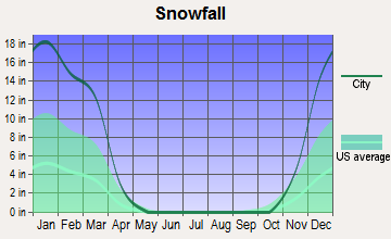
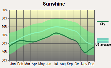
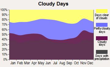
Average climate in Lyme, New Hampshire
Based on data reported by over 4,000 weather stations
(lower is better)
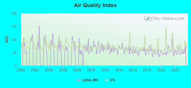
Air Quality Index (AQI) level in 2022 was 51.6. This is significantly better than average.
| City: | 51.6 |
| U.S.: | 72.6 |
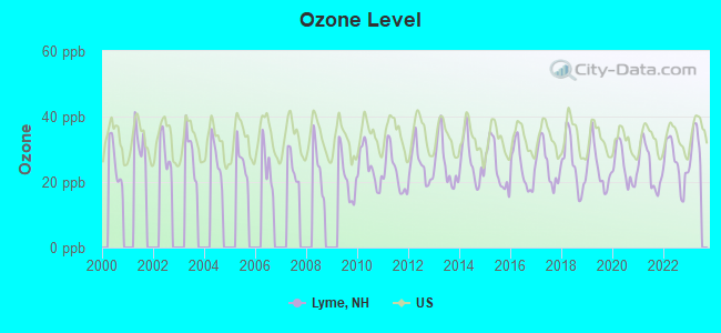
Ozone [ppb] level in 2022 was 25.6. This is better than average. Closest monitor was 13.8 miles away from the city center.
| City: | 25.6 |
| U.S.: | 33.3 |
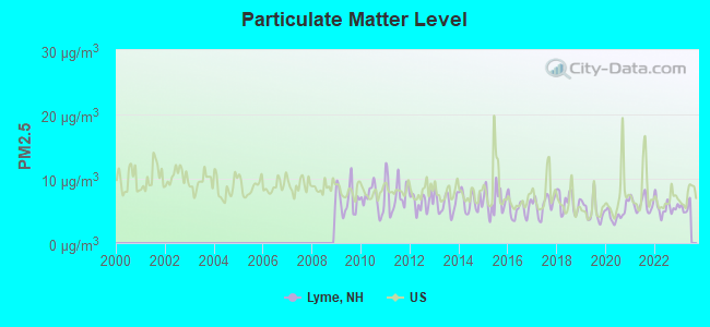
Particulate Matter (PM2.5) [µg/m3] level in 2022 was 5.54. This is significantly better than average. Closest monitor was 14.7 miles away from the city center.
| City: | 5.54 |
| U.S.: | 8.11 |
Tornado activity:
Lyme-area historical tornado activity is below New Hampshire state average. It is 71% smaller than the overall U.S. average.
On 8/11/1966, a category F2 (max. wind speeds 113-157 mph) tornado 13.8 miles away from the Lyme town center caused between $50,000 and $500,000 in damages.
On 5/11/1973, a category F2 tornado 18.7 miles away from the town center .
Earthquake activity:
Lyme-area historical earthquake activity is significantly above New Hampshire state average. It is 71% smaller than the overall U.S. average.On 4/20/2002 at 10:50:47, a magnitude 5.3 (5.3 ML, Depth: 3.0 mi, Class: Moderate, Intensity: VI - VII) earthquake occurred 91.6 miles away from the city center
On 10/7/1983 at 10:18:46, a magnitude 5.3 (5.1 MB, 5.3 LG, 5.1 ML) earthquake occurred 110.3 miles away from the city center
On 4/20/2002 at 10:50:47, a magnitude 5.2 (5.2 MB, 4.2 MS, 5.2 MW, 5.0 MW) earthquake occurred 91.5 miles away from the city center
On 1/19/1982 at 00:14:42, a magnitude 4.7 (4.5 MB, 4.7 MD, 4.5 LG, Class: Light, Intensity: IV - V) earthquake occurred 34.2 miles away from the city center
On 10/16/2012 at 23:12:25, a magnitude 4.7 (4.7 ML, Depth: 10.0 mi) earthquake occurred 75.5 miles away from the city center
On 6/16/1995 at 12:13:11, a magnitude 3.8 (3.8 LG, Depth: 3.1 mi, Class: Light, Intensity: II - III) earthquake occurred 35.2 miles away from Lyme center
Magnitude types: regional Lg-wave magnitude (LG), body-wave magnitude (MB), duration magnitude (MD), local magnitude (ML), surface-wave magnitude (MS), moment magnitude (MW)
Natural disasters:
The number of natural disasters in Grafton County (32) is a lot greater than the US average (15).Major Disasters (Presidential) Declared: 20
Emergencies Declared: 9
Causes of natural disasters: Floods: 16, Storms: 16, Hurricanes: 3, Snows: 3, Winter Storms: 3, Tropical Storms: 2, Blizzard: 1, Heavy Rain: 1, Ice Storm: 1, Landslide: 1, Snowfall: 1, Snowstorm: 1, Wind: 1, Other: 1 (Note: some incidents may be assigned to more than one category).

Hospitals and medical centers near Lyme:
- KENDAL AT HANOVER (Nursing Home, about 9 miles away; HANOVER, NH)
- HANOVER TERRACE HEALTHCARE (Nursing Home, about 9 miles away; HANOVER, NH)
- FRESENIUS MEDICAL CARE OF LEBANON (Dialysis Facility, about 11 miles away; LEBANON, NH)
- VNA AND HOSPICE OF VERMONT AND NH (Hospital, about 12 miles away; WHITE RIVER JUNCTION, VT)
- BROOKSIDE HEALTH AND REHABILITATION (Nursing Home, about 14 miles away; WHITE RIVER JUNCTION, VT)
- WHITE RIVER JCT VA MEDICAL CENTER (Hospital, Acute Care - Veterans Administration, about 14 miles away; WHITE RIVER JUNCTION, VT)
Amtrak station near Lyme:
Colleges/universities with over 2000 students nearest to Lyme:
- Dartmouth College (about 11 miles; Hanover, NH; Full-time enrollment: 6,030)
- Plymouth State University (about 23 miles; Plymouth, NH; FT enrollment: 4,838)
- Norwich University (about 35 miles; Northfield, VT; FT enrollment: 4,221)
- NHTI-Concord's Community College (about 51 miles; Concord, NH; FT enrollment: 2,865)
- Middlebury College (about 54 miles; Middlebury, VT; FT enrollment: 3,077)
- Castleton State College (about 54 miles; Castleton, VT; FT enrollment: 2,079)
- Keene State College (about 62 miles; Keene, NH; FT enrollment: 5,098)
Public elementary/middle school in Lyme:
- LYME ELEMENTARY SCHOOL (Students: 183, Location: RTE. 10, Grades: KG-8)
Private elementary/middle school in Lyme:
- CROSSROADS ACADEMY (Students: 138, Location: 95 DARTMOUTH COLLEGE HWY, Grades: KG-8)
Points of interest:
Notable locations in Lyme: Trapper John Shelter (A), Wilder Lake Campground (B), Dartmouth Skiway (C), DOC Camp (D), Lyme First Aid Stabilization Team Squad (E), Lyme Volunteer Fire Department (F), Lyme Congregational Church Horse Sheds (G). Display/hide their locations on the map
Church in Lyme: Lyme Congregational Church (A). Display/hide its location on the map
Lakes and reservoirs: Lily Pond (A), Little Clark Pond (B), Mud Pond (C), Post Pond (D), Pout Pond (E), Trout Pond (F), Stevenson Pond (G). Display/hide their locations on the map
Streams, rivers, and creeks: Smith Mountain Brook (A), Whipple Brook (B), Trout Brook (C), Hewes Brook (D), Grant Brook (E), Clay Brook (F). Display/hide their locations on the map
Parks in Lyme include: Wilder Management Area (1), Lyme Common Historic District (2). Display/hide their locations on the map
Hotels: The Dowd's Country Inn (5 Main Street) (1), Alden Country Inn (1 Market Street) (2). Display/hide their approximate locations on the map
Birthplace of: David Marston Clough - Politician, Baxter E. Perry - Massachusetts politician, Jonathan Child - Politician, Libe Washburn - Baseball player.
Drinking water stations with addresses in Lyme and their reported violations in the past:
LYME WATER (Population served: 283, Groundwater):Past health violations:Past monitoring violations:
- MCL, Monthly (TCR) - In JAN-2012, Contaminant: Coliform. Follow-up actions: St Public Notif requested (JAN-23-2012), St Violation/Reminder Notice (JAN-23-2012), St Public Notif received (FEB-07-2012), St Compliance achieved (AUG-08-2012)
- MCL, Monthly (TCR) - In SEP-2011, Contaminant: Coliform. Follow-up actions: St Public Notif requested (SEP-26-2011), St Violation/Reminder Notice (SEP-26-2011), St Public Notif received (OCT-06-2011), St Formal NOV issued (NOV-04-2011), St Compliance achieved (AUG-08-2012)
- MCL, Monthly (TCR) - In AUG-2011, Contaminant: Coliform. Follow-up actions: St Public Notif received (AUG-24-2011), St Public Notif requested (AUG-31-2011), St Violation/Reminder Notice (AUG-31-2011), St Formal NOV issued (NOV-04-2011), St Compliance achieved (AUG-08-2012)
- MCL, Monthly (TCR) - In AUG-2010, Contaminant: Coliform. Follow-up actions: St Formal NOV issued (AUG-27-2010), St Violation/Reminder Notice (AUG-27-2010), St Public Notif requested (AUG-27-2010), St Public Notif received (SEP-16-2010), St Compliance achieved (MAR-14-2011)
- MCL, Monthly (TCR) - In JUL-2010, Contaminant: Coliform. Follow-up actions: St Public Notif requested (JUL-28-2010), St Violation/Reminder Notice (JUL-28-2010), St Public Notif received (AUG-19-2010), St Formal NOV issued (AUG-27-2010), St Compliance achieved (MAR-14-2011)
- One minor monitoring violation
| This town: | 2.4 people |
| New Hampshire: | 2.5 people |
| This town: | 71.3% |
| Whole state: | 66.3% |
| This town: | 6.4% |
| Whole state: | 8.3% |
Likely homosexual households (counted as self-reported same-sex unmarried-partner households)
- Lesbian couples: 0.4% of all households
- Gay men: 0.1% of all households
| This town: | 4.2% |
| Whole state: | 6.5% |
| This town: | 1.4% |
| Whole state: | 2.8% |
10 people in homes for the mentally retarded in 2000
Banks with branches in Lyme (2011 data):
- Ledyard National Bank: Lyme Branch at Stella's Kitchen Building, Route 10, branch established on 1995/10/23. Info updated 2008/07/30: Bank assets: $390.6 mil, Deposits: $313.7 mil, headquarters in Norwich, VT, positive income, 7 total offices, Holding Company: Ledyard Financial Group, Inc.
- Mascoma Savings Bank: Lyme Branch at One Main Street, branch established on 1994/11/16. Info updated 2011/07/21: Bank assets: $990.7 mil, Deposits: $719.7 mil, headquarters in Lebanon, NH, positive income, Commercial Lending Specialization, 18 total offices
For population 15 years and over in Lyme:
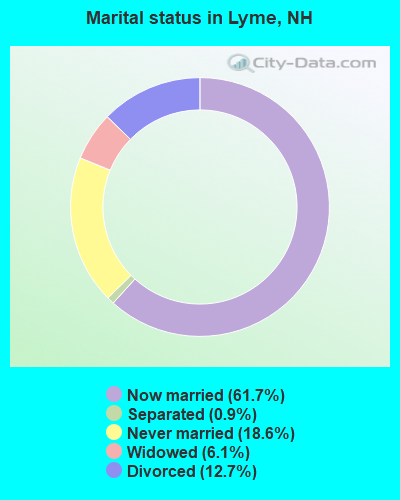
- Never married: 18.6%
- Now married: 61.7%
- Separated: 0.9%
- Widowed: 6.1%
- Divorced: 12.7%
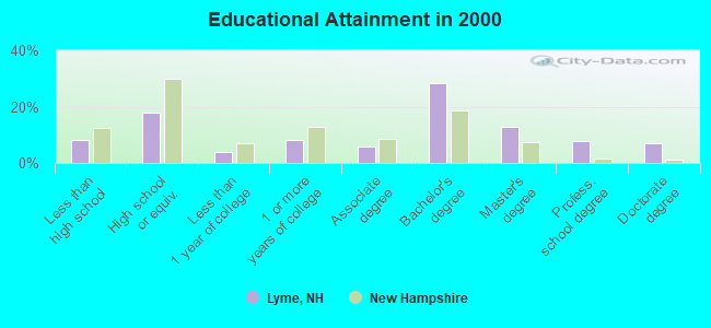
For population 25 years and over in Lyme:
- High school or higher: 91.7%
- Bachelor's degree or higher: 56.0%
- Graduate or professional degree: 27.5%
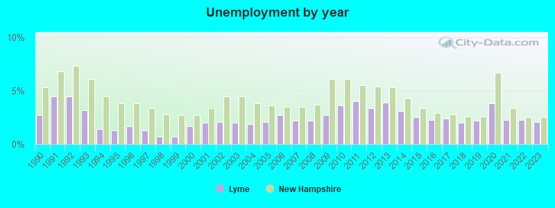
- Unemployed: 1.7%
- Mean travel time to work (commute): 21.1 minutes
| Here: | 13.0 |
| New Hampshire average: | 10.9 |


Graphs represent county-level data. Detailed 2008 Election Results
Religion statistics for Lyme, NH (based on Grafton County data)


| Religion | Adherents | Congregations |
|---|---|---|
| Catholic | 9,503 | 12 |
| Mainline Protestant | 7,832 | 57 |
| Evangelical Protestant | 1,494 | 29 |
| Other | 1,320 | 11 |
| None | 68,969 | - |
Food Environment Statistics:
| Here: | 3.87 / 10,000 pop. |
| New Hampshire: | 2.14 / 10,000 pop. |
| Grafton County: | 0.23 / 10,000 pop. |
| New Hampshire: | 0.15 / 10,000 pop. |
| Here: | 1.29 / 10,000 pop. |
| State: | 1.78 / 10,000 pop. |
| Grafton County: | 6.45 / 10,000 pop. |
| State: | 4.02 / 10,000 pop. |
| Here: | 14.41 / 10,000 pop. |
| New Hampshire: | 9.70 / 10,000 pop. |
| Here: | 7.2% |
| New Hampshire: | 7.6% |
| Grafton County: | 22.9% |
| New Hampshire: | 24.4% |
| Grafton County: | 15.9% |
| State: | 15.9% |
Businesses in Lyme, NH
- FedEx: 1
Strongest AM radio stations in Lyme:
- WNTK (1020 AM; 10 kW; NEWPORT, NH; Owner: KOOR COMMUNICATIONS, INC.)
- WPNH (1300 AM; 5 kW; PLYMOUTH, NH; Owner: NORTHEAST COMMUNICATIONS CORPORATION)
- WTWN (1100 AM; daytime; 5 kW; WELLS RIVER, VT; Owner: PUFFER BROADCASTING, INC.)
- WDCR (1340 AM; 1 kW; HANOVER, NH; Owner: TRUSTEES OF DARTMOUTH COLLEGE)
- WRKO (680 AM; 50 kW; BOSTON, MA; Owner: ENTERCOM BOSTON LICENSE, LLC)
- WTSL (1400 AM; 1 kW; HANOVER, NH; Owner: CAPSTAR TX LIMITED PARTNERSHIP)
- WNNZ (640 AM; 50 kW; WESTFIELD, MA; Owner: CLEAR CHANNEL BROADCASTING LICENSES, INC.)
- WCRN (830 AM; 50 kW; WORCESTER, MA; Owner: CARTER BROADCASTING CORPORATION)
- WEEI (850 AM; 50 kW; BOSTON, MA; Owner: ENTERCOM BOSTON LICENSE, LLC)
- WGY (810 AM; 50 kW; SCHENECTADY, NY; Owner: CLEAR CHANNEL BROADCASTING LICENSES, INC.)
- WCHP (760 AM; 35 kW; CHAMPLAIN, NY; Owner: CHAMPLAIN RADIO, INC.)
- WNHV (910 AM; 1 kW; WHITE RIVER JUNCTION, VT)
- WDEV (550 AM; 5 kW; WATERBURY, VT; Owner: RADIO VERMONT, INC.)
Strongest FM radio stations in Lyme:
- WEVH (91.3 FM; HANOVER, NH; Owner: NEW HAMPSHIRE PUBLIC RADIO INC)
- WPNH-FM (100.1 FM; PLYMOUTH, NH; Owner: NORTHEAST COMMUNICATIONS CORPORATION)
- WHDQ (106.1 FM; CLAREMONT, NH; Owner: GREAT NORTHERN RADIO, L.L.C.)
- WVPR (89.5 FM; WINDSOR, VT; Owner: VERMONT PUBLIC RADIO)
- WXXK (100.5 FM; LEBANON, NH; Owner: CAPSTAR TX LIMITED PARTNERSHIP)
- WRJT (103.1 FM; ROYALTON, VT; Owner: LISBON COMMUNICATIONS, INC.)
- WJJR (98.1 FM; RUTLAND, VT; Owner: 6 JOHNSON ROAD LICENSES, INC.)
- WZRT (97.1 FM; RUTLAND, VT; Owner: CAPSTAR TX LIMITED PARTNERSHIP)
- WEBK (105.3 FM; KILLINGTON, VT; Owner: 6 JOHNSON ROAD LICENSES, INC.)
- WVFM (105.7 FM; CAMPTON, NH; Owner: DEVON BROADCASTING COMPANY, INC.)
- WPKQ (103.7 FM; NORTH CONWAY, NH; Owner: CITADEL BROADCASTING COMPANY)
- WHOM (94.9 FM; MT. WASHINGTON, NH; Owner: CITADEL BROADCASTING COMPANY)
- WGLV (91.7 FM; WOODSTOCK, VT; Owner: CHRISTIAN MINISTRIES INC)
- WHDQ-FM1 (106.1 FM; RUTLAND, VT; Owner: GREAT NORTHERN RADIO, L.L.C.)
- WSCY (106.9 FM; MOULTONBOROUGH, NH; Owner: NORTHEAST COMMUNICATIONS CORPORATION)
- WDEV-FM (96.1 FM; WARREN, VT; Owner: RADIO VERMONT, INC.)
- WWOD (104.3 FM; HARTFORD, VT; Owner: FAMILY BROADCASTING, INC.)
- WCVT (101.7 FM; STOWE, VT; Owner: RADIO VERMONT CLASSICS, L.L.C.)
- WMXR (93.9 FM; WOODSTOCK, VT; Owner: CLEAR CHANNEL BROADCASTING LICENSES, INC.)
- WVRR (101.7 FM; NEWPORT, NH; Owner: CAPSTAR TX LIMITED PARTNERSHIP)
TV broadcast stations around Lyme:
- W15BK (Channel 15; HANOVER, NH; Owner: UNIVERSITY OF NEW HAMPSHIRE)
Lyme fatal accident list:
Oct 7, 1990 06:25 PM, Sr10, Vehicles: 1, Persons: 1, Fatalities: 1
Dec 10, 1988 00:44 AM, 2279, Vehicles: 2, Persons: 3, Fatalities: 2
- National Bridge Inventory (NBI) Statistics
- 11Number of bridges
- 92ft / 28.0mTotal length
- $34,562,000Total costs
- 12,790Total average daily traffic
- 887Total average daily truck traffic
- 18,924Total future (year 2042) average daily traffic
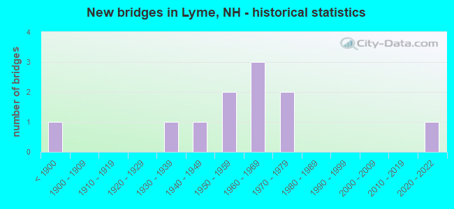
- New bridges - historical statistics
- 1Before 1900
- 11930-1939
- 11940-1949
- 21950-1959
- 31960-1969
- 21970-1979
- 12020-2022
FCC Registered Broadcast Land Mobile Towers:
1- Route 10 (Lat: 43.870333 Lon: -72.150639), Call Sign: KNDP529,
Assigned Frequencies: 150.845 MHz, Grant Date: 06/14/2012, Expiration Date: 09/09/2022, Cancellation Date: 11/12/2022, Registrant: Universal Licensing Service, 4401-A Connecticut Ave Nw #232, Washington, DC 20008-2358, Phone: (877) 677-3639, Fax: (949) 209-3097, Email:
FCC Registered Amateur Radio Licenses:
19 (See the full list of FCC Registered Amateur Radio Licenses in Lyme)FAA Registered Aircraft:
9 (See the full list of FAA Registered Aircraft in Lyme)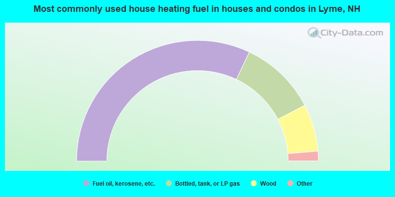
- 64.2%Fuel oil, kerosene, etc.
- 20.6%Bottled, tank, or LP gas
- 12.7%Wood
- 2.0%Electricity
- 0.4%Solar energy
- 0.2%Utility gas
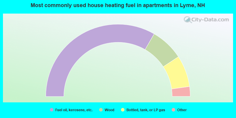
- 66.7%Fuel oil, kerosene, etc.
- 14.8%Wood
- 14.1%Bottled, tank, or LP gas
- 3.0%Utility gas
- 1.5%Electricity
Lyme compared to New Hampshire state average:
- Median house value above state average.
- Unemployed percentage significantly below state average.
- Black race population percentage significantly below state average.
- Hispanic race population percentage below state average.
- Foreign-born population percentage significantly below state average.
- Length of stay since moving in significantly above state average.
- Number of rooms per house significantly below state average.
- House age significantly below state average.
- Percentage of population with a bachelor's degree or higher above state average.

|
|
Total of 90 patent applications in 2008-2024.