Estimated median house or condo value in 2022: $630,624 (it was $253,100 in 2000)
Norwich:
$630,624
VT:
$304,700
Mean prices in 2022:all housing units: $358,264; detached houses: $381,996; townhouses or other attached units: $340,107; in 2-unit structures: $283,645; in 3-to-4-unit structures: $498,076; in 5-or-more-unit structures: $190,965; mobile homes: $75,013March 2022 cost of living index in Norwich: 106.1 (more than average, U.S. average is 100)
According to our research of Vermont and other state lists, there were 3 registered sex offenders living in Norwich, Vermont as of April 27, 2024. The ratio of all residents to sex offenders in Norwich is 1,138 to 1. The ratio of registered sex offenders to all residents in this city is much lower than the state average.
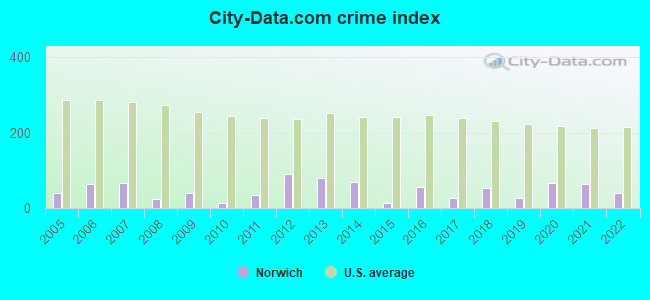
Crime rates in Norwich by year
Type
2009
2010
2011
2012
2013
2014
2015
2016
2017
2018
2019
2020
2021
2022
Murders (per 100,000)
0 (0.0)
0 (0.0)
0 (0.0)
0 (0.0)
0 (0.0)
0 (0.0)
0 (0.0)
0 (0.0)
0 (0.0)
0 (0.0)
0 (0.0)
0 (0.0)
0 (0.0)
0 (0.0)
Rapes (per 100,000)
0 (0.0)
0 (0.0)
0 (0.0)
0 (0.0)
0 (0.0)
1 (29.5)
0 (0.0)
1 (29.7)
0 (0.0)
1 (30.3)
0 (0.0)
1 (29.3)
1 (29.4)
0 (0.0)
Robberies (per 100,000)
0 (0.0)
0 (0.0)
0 (0.0)
0 (0.0)
0 (0.0)
0 (0.0)
0 (0.0)
0 (0.0)
1 (29.9)
0 (0.0)
0 (0.0)
0 (0.0)
0 (0.0)
0 (0.0)
Assaults (per 100,000)
2 (56.8)
0 (0.0)
0 (0.0)
0 (0.0)
0 (0.0)
0 (0.0)
0 (0.0)
1 (29.7)
0 (0.0)
1 (30.3)
1 (30.2)
2 (58.7)
1 (29.4)
1 (27.2)
Burglaries (per 100,000)
8 (227.3)
2 (58.6)
8 (234.1)
21 (615.5)
18 (531.4)
8 (236.3)
0 (0.0)
2 (59.4)
3 (89.7)
5 (151.3)
3 (90.7)
7 (205.3)
1 (29.4)
5 (135.8)
Thefts (per 100,000)
12 (341.0)
8 (234.3)
10 (292.6)
37 (1,084)
29 (856.2)
22 (649.9)
10 (295.9)
18 (534.3)
7 (209.4)
7 (211.9)
9 (272.1)
11 (322.7)
24 (705.9)
17 (461.8)
Auto thefts (per 100,000)
0 (0.0)
0 (0.0)
3 (87.8)
2 (58.6)
4 (118.1)
1 (29.5)
0 (0.0)
0 (0.0)
1 (29.9)
1 (30.3)
1 (30.2)
2 (58.7)
2 (58.8)
3 (81.5)
Arson (per 100,000)
0 (0.0)
0 (0.0)
0 (0.0)
2 (58.6)
0 (0.0)
0 (0.0)
0 (0.0)
0 (0.0)
0 (0.0)
0 (0.0)
0 (0.0)
0 (0.0)
0 (0.0)
0 (0.0)
City-Data.com crime index
40.9
13.5
35.1
91.1
80.9
68.5
11.8
55.2
26.0
51.8
25.7
67.2
64.4
39.9
The City-Data.com crime index weighs serious crimes and violent crimes more heavily. Higher means more crime, U.S. average is 246.1. It adjusts for the number of visitors and daily workers commuting into cities.
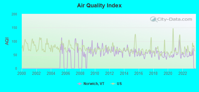
Air Quality Index (AQI) level in 2022 was 51.4. This is significantly better than average.
City:
51.4
U.S.:
72.6
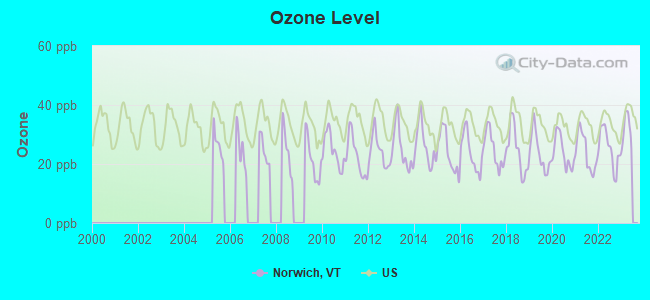
Ozone [ppb] level in 2022 was 25.3. This is better than average.Closest monitor was 5.5 miles away from the city center.
City:
25.3
U.S.:
33.3
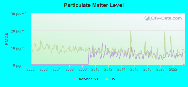
Particulate Matter (PM2.5) [µg/m3] level in 2022 was 5.54. This is significantly better than average.Closest monitor was 7.0 miles away from the city center.
City:
5.54
U.S.:
8.11
Tornado activity:
Norwich-area historical tornado activity is slightly above Vermont state average. It is 69% smaller than the overall U.S. average.
On 5/11/1973, a category F2 (max. wind speeds 113-157 mph) tornado 20.9 miles away from the Norwich town center .
On 8/11/1966, a category F2 tornado 21.2 miles away from the town center causedbetween $50,000 and $500,000 in damages.
Earthquake activity:
Norwich-area historical earthquake activity is significantly above Vermont state average. It is 70% smaller than the overall U.S. average.
On 4/20/2002 at 10:50:47, a magnitude 5.3 (5.3 ML, Depth: 3.0 mi, Class: Moderate, Intensity: VI - VII) earthquake occurred 87.9 miles away from the city center On 10/7/1983 at 10:18:46, a magnitude 5.3 (5.1 MB, 5.3 LG, 5.1 ML) earthquake occurred 102.9 miles away from the city center On 4/20/2002 at 10:50:47, a magnitude 5.2 (5.2 MB, 4.2 MS, 5.2 MW, 5.0 MW) earthquake occurred 87.6 miles away from Norwich center On 1/19/1982 at 00:14:42, a magnitude 4.7 (4.5 MB, 4.7 MD, 4.5 LG, Class: Light, Intensity: IV - V) earthquake occurred 38.6 miles away from Norwich center On 10/16/2012 at 23:12:25, a magnitude 4.7 (4.7 ML, Depth: 10.0 mi) earthquake occurred 82.9 miles away from the city center On 6/16/1995 at 12:13:11, a magnitude 3.8 (3.8 LG, Depth: 3.1 mi, Class: Light, Intensity: II - III) earthquake occurred 43.0 miles away from Norwich center Magnitude types: regional Lg-wave magnitude (LG), body-wave magnitude (MB), duration magnitude (MD), local magnitude (ML), surface-wave magnitude (MS), moment magnitude (MW)
Natural disasters:
The number of natural disasters in Windsor County (20) is greater than the US average (15). Major Disasters (Presidential) Declared: 16 Emergencies Declared: 2
Causes of natural disasters: Floods: 14, Storms: 13, Tropical Storms: 2, Heavy Rain: 1, Hurricane: 1, Ice Storm: 1, Landslide: 1, Snowstorm: 1, Wind: 1, Winter Storm: 1 (Note: some incidents may be assigned to more than one category).
Hospitals and medical centers near Norwich:
HANOVER TERRACE HEALTHCARE (Nursing Home, about 2 miles away; HANOVER, NH)
KENDAL AT HANOVER (Nursing Home, about 2 miles away; HANOVER, NH)
VNA AND HOSPICE OF VERMONT AND NH (Hospital, about 3 miles away; WHITE RIVER JUNCTION, VT)
BROOKSIDE HEALTH AND REHABILITATION (Nursing Home, about 5 miles away; WHITE RIVER JUNCTION, VT)
FRESENIUS MEDICAL CARE OF LEBANON (Dialysis Facility, about 6 miles away; LEBANON, NH)
WHITE RIVER JCT VA MEDICAL CENTER (Hospital, Acute Care - Veterans Administration, about 6 miles away; WHITE RIVER JUNCTION, VT)
Amtrak stations near Norwich:
6 miles: WHITE RIVER JUNCTION (RAILROAD ROW) . Services: ticket office, fully wheelchair accessible, enclosed waiting area, public restrooms, public payphones, free short-term parking, paid long-term parking, call for car rental service, call for taxi service, public transit connection.
18 miles: WINDSOR-MOUNT ASCUTNEY (WINDSOR, DEPOT AVE.) . Services: public payphones, free short-term parking, free long-term parking, call for car rental service, intercity bus service.
NORWICH PUBLIC (Operating income: $256,663; Location: 368 MAIN ST.; 28,833 books; 2,189 audio materials; 1,984 video materials; 8 local licensed databases; 19 state licensed databases; 83 print serial subscriptions; 1 electronic serial subscriptions)
Tourist attraction: Montshire Museum of Science (1 Montshire Road).
Birthplace of: Edward Bancroft Williston - Army Medal of Honor recipient, George Wright (general) - Union Army general, Thomas E. G. Ransom - Union Army general, Charles L. Bartlett (mayor) - Politician, George A. Converse - Soilder.
Windsor County has a predicted average indoor radon screening level between 2 and 4 pCi/L (pico curies per liter) - Moderate Potential
Drinking water stations with addresses in Norwich and their reported violations in the past:
NORWICH FIRE DISTRICT 1 (Population served: 870, Groundwater):
Past monitoring violations:
One routine major monitoring violation
MONTSHIRE MUSEUM OF SCIENCE (Address: 1 MONTSHIRE RD , Population served: 450, Groundwater):
Past health violations:
MCL, Monthly (TCR) - In JUN-2014, Contaminant: Coliform. Follow-up actions: St Public Notif requested (JUN-19-2014), St Formal NOV issued (JUN-19-2014), St Public Notif received (JUN-30-2014)
MCL, Monthly (TCR) - In JUN-2013, Contaminant: Coliform. Follow-up actions: St Tech Assistance Visit (JUN-18-2013), St Formal NOV issued (JUN-18-2013), St Public Notif requested (JUN-18-2013), St Boil Water Order (JUN-18-2013), St Public Notif received (JUL-01-2013)
MCL, Monthly (TCR) - In AUG-2012, Contaminant: Coliform. Follow-up actions: St Tech Assistance Visit (AUG-29-2012), St Formal NOV issued (AUG-29-2012), St Public Notif requested (AUG-29-2012), St Boil Water Order (AUG-29-2012), St Compliance achieved (OCT-08-2012)
MCL, Monthly (TCR) - In NOV-2007, Contaminant: Coliform. Follow-up actions: St Formal NOV issued (NOV-27-2007), St Public Notif requested (NOV-27-2007), St Public Notif received (DEC-10-2007), St Compliance achieved (SEP-25-2009)
MCL, Monthly (TCR) - In MAR-2007, Contaminant: Coliform. Follow-up actions: St Public Notif requested (MAR-19-2007), St Formal NOV issued (MAR-19-2007), St Public Notif received (MAR-27-2007), St Compliance achieved (APR-20-2007)
MCL, Monthly (TCR) - Between JAN-2007 and MAR-2007, Contaminant: Coliform. Follow-up actions: St Tech Assistance Visit (MAR-02-2007), St Formal NOV issued (MAR-02-2007), St Boil Water Order (MAR-02-2007), St Public Notif requested (MAR-02-2007), St Public Notif received (MAR-27-2007), St Compliance achieved (APR-20-2007)
MCL, Monthly (TCR) - In SEP-2007, Contaminant: Coliform. Follow-up actions: St Formal NOV issued (OCT-03-2007), St Public Notif requested (OCT-03-2007), St Public Notif received (OCT-10-2007), St Compliance achieved (SEP-25-2009)
Past monitoring violations:
Monitoring and Reporting (DBP) - Between APR-2008 and JUN-2008, Contaminant: Chlorine. Follow-up actions: St Public Notif requested (JAN-15-2009), St Formal NOV issued (JAN-15-2009), St Public Notif received (JUL-01-2009), St Compliance achieved (MAR-17-2011)
One routine major monitoring violation
2 regular monitoring violations
CHILD CARE CENTER IN NORWICH (Address: 75 MONSHIRE RD , Population served: 65, Groundwater):
Past health violations:
MCL, Monthly (TCR) - In AUG-2012, Contaminant: Coliform. Follow-up actions: St Tech Assistance Visit (AUG-10-2012), St Formal NOV issued (AUG-10-2012), St Public Notif requested (AUG-10-2012), St Boil Water Order (AUG-10-2012), St Compliance achieved (SEP-06-2012)
Past monitoring violations:
Follow-up Or Routine LCR Tap M/R - In JAN-01-1997, Contaminant: Lead and Copper Rule. Follow-up actions: St Violation/Reminder Notice (JUL-01-1997)
HAWK PINE HILLS (Address: 152 HAWK PINE RD , Population served: 60, Groundwater):
Past health violations:
MCL, Monthly (TCR) - In OCT-2008, Contaminant: Coliform. Follow-up actions: St Formal NOV issued (OCT-07-2008), St Public Notif requested (OCT-07-2008), St Public Notif received (OCT-27-2008), St Compliance achieved (JAN-29-2010)
Past monitoring violations:
Monitoring and Reporting (DBP) - Between JAN-2014 and MAR-2014, Contaminant: Chlorine. Follow-up actions: St Formal NOV issued (MAY-09-2014), St Public Notif requested (MAY-09-2014)
Monitoring and Reporting (DBP) - Between APR-2013 and JUN-2013, Contaminant: Chlorine. Follow-up actions: St Formal NOV issued (MAY-21-2013), St Compliance achieved (JUN-07-2013)
Monitoring, Repeat Major (TCR) - In APR-2008, Contaminant: Coliform (TCR). Follow-up actions: St Formal NOV issued (MAY-16-2008), St Public Notif requested (MAY-16-2008), St Public Notif received (JUN-30-2009), St Compliance achieved (JAN-29-2010)
Monitoring and Reporting (DBP) - Between JAN-2008 and MAR-2008, Contaminant: Chlorine. Follow-up actions: St Public Notif requested (JUL-22-2008), St Formal NOV issued (JUL-22-2008), St Public Notif received (JUN-30-2009), St Compliance achieved (MAR-17-2011)
MCL, Monthly (TCR) - In AUG-2013, Contaminant: Coliform. Follow-up actions: St Tech Assistance Visit (AUG-16-2013), St Formal NOV issued (AUG-16-2013), St Public Notif requested (AUG-16-2013), St Boil Water Order (AUG-16-2013), St Compliance achieved (AUG-23-2013)
MCL, Monthly (TCR) - In OCT-2008, Contaminant: Coliform. Follow-up actions: St Boil Water Order (OCT-23-2008), St Formal NOV issued (OCT-23-2008), St Tech Assistance Visit (OCT-23-2008), St Public Notif requested (OCT-23-2008), St Compliance achieved (AUG-09-2010)
Past monitoring violations:
2 routine major monitoring violations
23 regular monitoring violations
Drinking water stations with addresses in Norwich that have no violations reported:
KING ARTHUR FLOUR COMPANY (Address: 135 US ROUTE 5 SOUTH , Population served: 84,Primary Water Source Type: Groundwater)
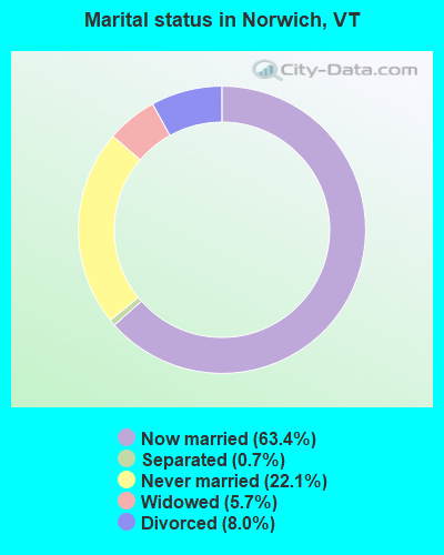
Average household size:
This town:
2.5 people
Vermont:
2.3 people
Percentage of family households:
This town:
68.2%
Whole state:
62.5%
Percentage of households with unmarried partners:
This town:
5.9%
Whole state:
9.2%
Likely homosexual households (counted as self-reported same-sex unmarried-partner households)
Lesbian couples: 1.2% of all households
Gay men: 0.5% of all households
Residents with income below the poverty level in 2009:
This town:
3.8%
Whole state:
9.4%
Residents with income below 50% of the poverty level in 2009:
This town:
1.9%
Whole state:
3.6%
Banks with branches in Norwich (2011 data):
Mascoma Savings Bank: Norwich Branch at 303 Main Street, branch established on 1965/11/22. Info updated 2011/07/21: Bank assets: $990.7 mil, Deposits: $719.7 mil, headquarters in Lebanon, NH, positive income, Commercial Lending Specialization, 18 total offices
Ledyard National Bank: at 320 Main Street, branch established on 1991/05/22. Info updated 2008/07/30: Bank assets: $390.6 mil, Deposits: $313.7 mil, local headquarters, positive income, 7 total offices, Holding Company: Ledyard Financial Group, Inc.
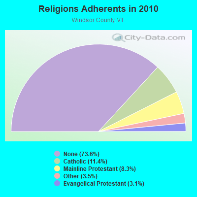
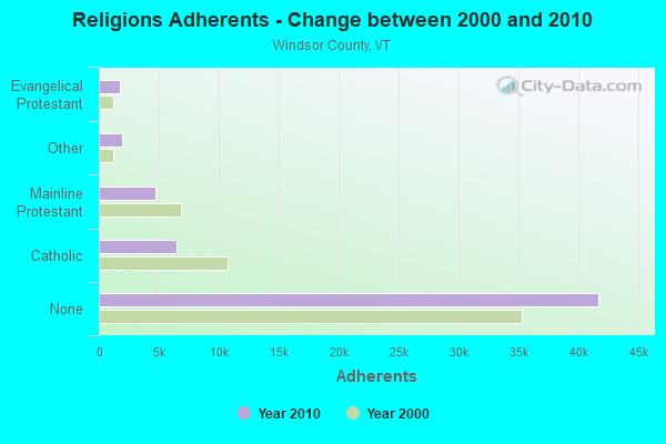
Religion statistics for Norwich, VT (based on Windsor County data)
Religion
Adherents
Congregations
Catholic
6,485
10
Mainline Protestant
4,700
45
Other
1,964
17
Evangelical Protestant
1,750
21
Orthodox
55
1
None
41,716
-
Source: Clifford Grammich, Kirk Hadaway, Richard Houseal, Dale E.Jones, Alexei Krindatch, Richie Stanley and Richard H.Taylor. 2012. 2010 U.S.Religion Census: Religious Congregations & Membership Study. Association of Statisticians of American Religious Bodies. Jones, Dale E., et al. 2002. Congregations and Membership in the United States 2000. Nashville, TN: Glenmary Research Center. Graphs represent county-level data
Off New Boston Road (Lat: 43.735306 Lon: -72.313528), Type: Tower, Structure height: 54.9 m, Overall height: 60.7 m, Call Sign: KSI330, Licensee ID: L00117535, Assigned Frequencies: 156.165 MHz, 154.325 MHz, Grant Date: 10/05/2023, Expiration Date: 12/30/2033, Registrant: Norwich, Town Of
Aircraft: SCHWEIZER SGS 1-26E (Category: Land, Weight: Up to 12,499 Pounds, Speed: 57 mph), Engine: None N-Number: 1115S, N1115S, N-1115S, Serial Number: 505, Airworthiness Date: 04/29/1971, Certificate Issue Date: 12/13/2018 Registrant (Corporation): Post Mills Soaring Club, 164 Kendall Station Rd, Norwich, VT 05055
Aircraft: EIRIAVION OY PIK 20D (Category: Land, Weight: Up to 12,499 Pounds), Engine: None N-Number: 22UU, N22UU, N-22UU, Serial Number: 20511, Year manufactured: 1977, Airworthiness Date: 05/16/1977, Certificate Issue Date: 02/27/2014 Registrant (Individual): Timothy Chow, 164 Kendall Station Rd, Norwich, VT 05055
Aircraft: GRUMMAN AMERICAN AVN. CORP. AA-5B (Category: Land, Seats: 4, Weight: Up to 12,499 Pounds, Speed: 105 mph), Engine: LYCOMING O&VO-360 SER (180 HP) (Reciprocating) N-Number: 28320, N28320, N-28320, Serial Number: AA5B0559, Year manufactured: 1977, Airworthiness Date: 08/23/1983, Certificate Issue Date: 08/28/2009 Registrant (Co-Owned): Stephen N Flanders, 317 Hopson Rd, Norwich, VT 05055, Other Owners: Geza Fejes-Toth
Aircraft: HPH SPOL SRO KUTNA HORA GLASFLUGEL 304CZ-17 (Category: Land, Weight: Up to 12,499 Pounds), Engine: None N-Number: 304BU, N304BU, N-304BU, Serial Number: 41-17, Year manufactured: 2001, Airworthiness Date: 01/10/2002, Certificate Issue Date: 03/27/2018 Registrant (Individual): Timothy Chow, 164 Kendall Station Rd, Norwich, VT 05055
Aircraft: AERONCA 7AC (Category: Land, Seats: 2, Weight: Up to 12,499 Pounds, Speed: 90 mph), Engine: CONT MOTOR C85 SERIES (85 HP) (Reciprocating) N-Number: 82660, N82660, N-82660, Serial Number: 7AC-1301, Year manufactured: 1946, Airworthiness Date: 05/24/1956, Certificate Issue Date: 09/28/2006 Registrant (Individual): Timothy Chow, 164 Kendall Station Rd, Norwich, VT 05055
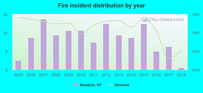
2005 - 2018 National Fire Incident Reporting System (NFIRS) incidents
According to the data from the years 2005 - 2018 the average number of fire incidents per year is 14. The highest number of fires - 22 took place in 2007, and the least - 1 in 2018. The data has a decreasing trend.
When looking into fire subcategories, the most incidents belonged to: Structure Fires (54.0%), and Outside Fires (25.4%).
Fire incident types reported to NFIRS in Norwich, VT


 Recent articles from our blog. Our writers, many of them Ph.D. graduates or candidates, create easy-to-read articles on a wide variety of topics.

 (66.9 miles


 According to the data from the years 2005 - 2018 the average number of fire incidents per year is 14. The highest number of fires - 22 took place in 2007, and the least - 1 in 2018. The data has a decreasing trend.
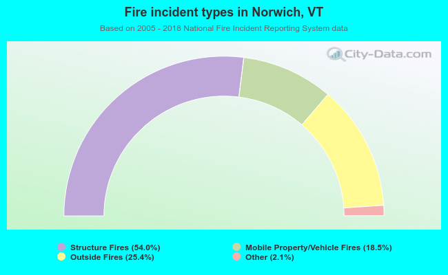 When looking into fire subcategories, the most incidents belonged to: Structure Fires (54.0%), and Outside Fires (25.4%).