Percentage of residents living in poverty in 2022: 11.2%
(11.1% for White Non-Hispanic residents, 100.0% for Black residents, 5.9% for Hispanic or Latino residents, 9.8% for other race residents, 9.4% for two or more races residents)
Latest news from Magalia, CA collected exclusively by city-data.com from local newspapers, TV, and radio stations
Ancestries: American (19.8%), English (15.6%), German (9.3%), European (5.5%), Armenian (4.7%), Italian (2.6%).
Current Local Time: PST time zone
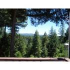
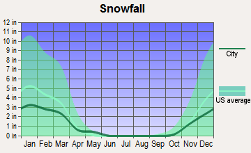
Elevation: 2400 feet
Land area: 14.1 square miles.
Population density: 804 people per square mile (low).
313 residents are foreign born (1.6% Asia, 0.8% Latin America, 0.6% Europe, 0.4% North America).
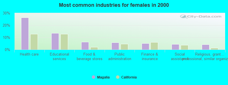
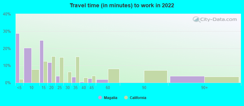
This place:
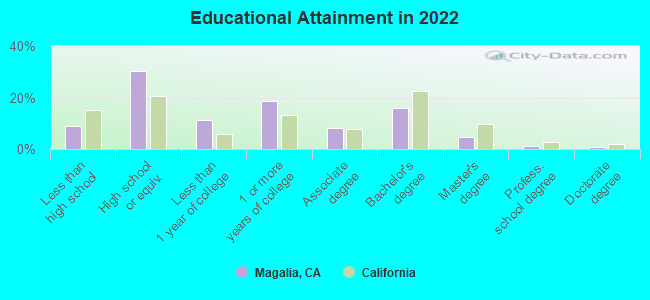
3.5%
California:
26.5%
Median real estate property taxes paid for housing units with mortgages in 2022: $1,674 (0.6%) Median real estate property taxes paid for housing units with no mortgage in 2022: $1,249 (0.5%)
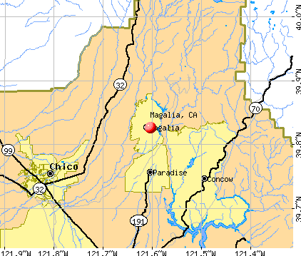
Nearest city with pop. 50,000+: Chico, CA (13.7 miles , pop. 59,954).
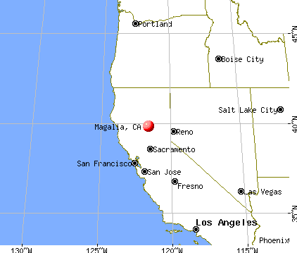
Nearest city with pop. 200,000+: Sacramento, CA (88.2 miles , pop. 407,018).
Nearest city with pop. 1,000,000+: Los Angeles, CA (435.2 miles , pop. 3,694,820).
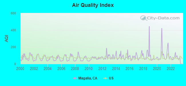
Air Quality Index (AQI) level in 2022 was 79.1. This is about average.
City:
79.1
U.S.:
72.6
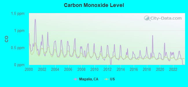
Carbon Monoxide (CO) [ppm] level in 2022 was 0.233. This is about average.Closest monitor was 13.4 miles away from the city center.
City:
0.233
U.S.:
0.251
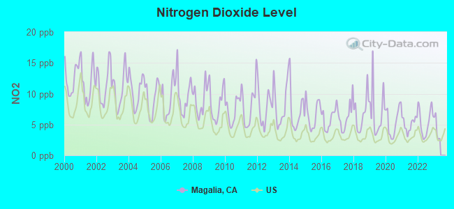
Nitrogen Dioxide (NO2) [ppb] level in 2022 was 5.46. This is about average.Closest monitor was 13.4 miles away from the city center.
City:
5.46
U.S.:
5.11
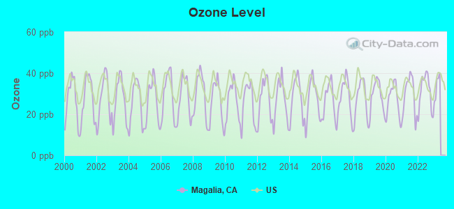
Ozone [ppb] level in 2022 was 31.0. This is about average.Closest monitor was 4.7 miles away from the city center.
City:
31.0
U.S.:
33.3
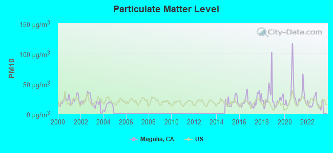
Particulate Matter (PM10) [µg/m3] level in 2022 was 19.2. This is about average.Closest monitor was 5.2 miles away from the city center.
City:
19.2
U.S.:
19.2
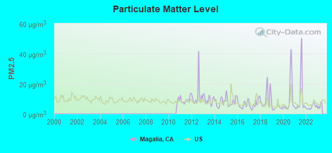
Particulate Matter (PM2.5) [µg/m3] level in 2022 was 4.76. This is significantly better than average.Closest monitor was 13.4 miles away from the city center.
City:
4.76
U.S.:
8.11
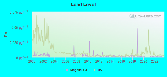
Lead (Pb) [µg/m3] level in 2023 was 0.00184. This is significantly better than average.Closest monitor was 13.4 miles away from the city center.
City:
0.00184
U.S.:
0.00931
Earthquake activity:
Magalia-area historical earthquake activity is significantly above California state average. It is 6465% greater than the overall U.S. average.
On 4/18/1906 at 13:12:21, a magnitude 7.9 (7.9 UK, Class: Major, Intensity: VIII - XII) earthquake occurred 147.0 miles away from Magalia center, causing $524,000,000 total damage On 1/31/1922 at 13:17:28, a magnitude 7.6 (7.6 UK) earthquake occurred 217.0 miles away from the city center On 10/3/1915 at 06:52:48, a magnitude 7.6 (7.6 UK) earthquake occurred 221.8 miles away from Magalia center On 4/25/1992 at 18:06:04, a magnitude 7.2 (6.3 MB, 7.1 MS, 7.2 MW, 7.1 MW, Depth: 9.4 mi) earthquake occurred 135.4 miles away from the city center, causing $75,000,000 total damage On 11/8/1980 at 10:27:34, a magnitude 7.2 (6.2 MB, 7.2 MS, 7.2 MW, 7.0 ML) earthquake occurred 167.4 miles away from Magalia center On 1/22/1923 at 09:04:18, a magnitude 7.2 (7.2 UK) earthquake occurred 201.9 miles away from the city center Magnitude types: body-wave magnitude (MB), local magnitude (ML), surface-wave magnitude (MS), moment magnitude (MW)
Natural disasters:
The number of natural disasters in Butte County (25) is a lot greater than the US average (15). Major Disasters (Presidential) Declared: 11 Emergencies Declared: 4
Causes of natural disasters: Floods: 12, Fires: 9, Winter Storms: 6, Storms: 5, Landslides: 4, Mudslides: 4, Drought: 1, Freeze: 1, Heavy Rain: 1, Hurricane: 1, Tornado: 1, Other: 1 (Note: some incidents may be assigned to more than one category).
Hospitals and medical centers near Magalia:
PINE VIEW CARE CENTER (Nursing Home, about 3 miles away; PARADISE, CA)
CYPRESS ACRES CONVALESCENT HOSPITAL (Nursing Home, about 3 miles away; PARADISE, CA)
CYPRESS HEALTHCARE CENTER (Nursing Home, about 4 miles away; PARADISE, CA)
FEATHER RIVER HHA (Home Health Center, about 4 miles away; PARADISE, CA)
PARADISE SKILLED NURSING (Nursing Home, about 5 miles away; PARADISE, CA)
CALIFORNIA HEALTH PROFESSIONALS (Home Health Center, about 5 miles away; PARADISE, CA)
FEATHER RIVER HOSPITAL Acute Care Hospitals (about 6 miles away; PARADISE, CA)
Amtrak station near Magalia:
15 miles: CHICO (W. 5TH & ORANGE STS.) . Services: partially wheelchair accessible, enclosed waiting area, public restrooms, public payphones, free short-term parking, free long-term parking, call for taxi service, intercity bus service, public transit connection.
Colleges/universities with over 2000 students nearest to Magalia:
Butte College (about 13 miles; Oroville, CA; Full-time enrollment: 8,649)
California State University-Chico (about 15 miles; Chico, CA; FT enrollment: 14,838)
Yuba College (about 49 miles; Marysville, CA; FT enrollment: 4,737)
Shasta College (about 67 miles; Redding, CA; FT enrollment: 5,645)
Sierra College (about 75 miles; Rocklin, CA; FT enrollment: 11,488)
Universal Technical Institute of Northern California Inc (about 82 miles; Sacramento, CA; FT enrollment: 3,193)
American River College (about 83 miles; Sacramento, CA; FT enrollment: 20,452)
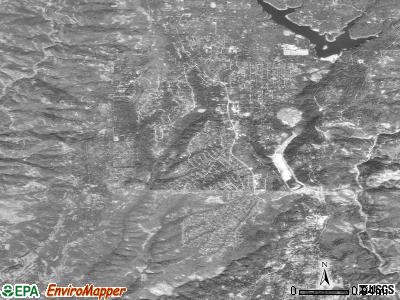
Notable locations in Magalia: Magalia Camp (A), First Responder Emergency Medical Services Station 11 (B), Butte County Fire Department Station 33 (C), Butte County Fire Department Station 31 (D). Display/hide their locations on the map
Likely homosexual households (counted as self-reported same-sex unmarried-partner households)
Lesbian couples: 0.4% of all households
Gay men: 0.4% of all households
13 people in group homes intended for adults in 2010
61 people in local jails and other confinement facilities (including police lockups) in 2000
59 people in other noninstitutional group quarters in 2000
Banks with branches in Magalia (2011 data):
Rabobank, National Association: Lakeridge Circle Branch at 14001 Lakeridge Circle, branch established on 1993/06/01. Info updated 2011/01/27: Bank assets: $11,745.0 mil, Deposits: $8,446.0 mil, headquarters in Roseville, CA, positive income, Agricultural Specialization, 124 total offices, Holding Company: Cooperatieve Centrale Raiffeisen-Boerenleenbank B.A., "rabobank Nederland
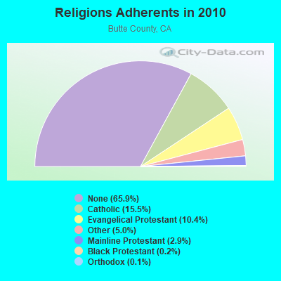
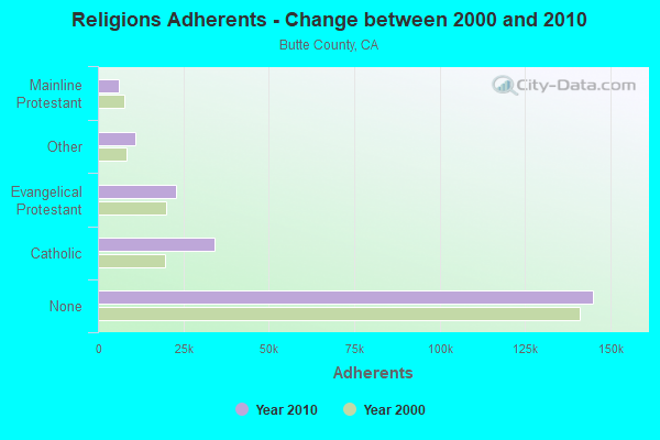
Religion statistics for Magalia, CA (based on Butte County data)
Religion
Adherents
Congregations
Catholic
34,101
7
Evangelical Protestant
22,822
129
Other
11,031
36
Mainline Protestant
6,272
24
Black Protestant
475
4
Orthodox
280
2
None
145,019
-
Source: Clifford Grammich, Kirk Hadaway, Richard Houseal, Dale E.Jones, Alexei Krindatch, Richie Stanley and Richard H.Taylor. 2012. 2010 U.S.Religion Census: Religious Congregations & Membership Study. Association of Statisticians of American Religious Bodies. Jones, Dale E., et al. 2002. Congregations and Membership in the United States 2000. Nashville, TN: Glenmary Research Center. Graphs represent county-level data
MAGALIA, 13700 Old Skyway (Lat: 39.808250 Lon: -121.578528), Type: Pole, Structure height: 53.6 m, Overall height: 54.9 m, Call Sign: WMM845, Assigned Frequencies: 10617.5 MHz, Grant Date: 01/04/2011, Expiration Date: 02/01/2021, Cancellation Date: 03/16/2015, Certifier: Carol L Tacker, Registrant: At&t Mobility LLC, 1120 20th Street, Nw - Suite 1000, Washington, DC 20036, Phone: (202) 457-2055, Fax: (202) 457-3073, Email:
STATION, Tank A 1/2 Mi S Of (Lat: 39.800694 Lon: -121.584417), Structure height: 9.1 m, Call Sign: WNTV902, Assigned Frequencies: 952.556 MHz, 928.556 MHz, Grant Date: 08/03/1999, Expiration Date: 08/12/2009, Cancellation Date: 05/20/2009, Registrant: Radio Licensing Services, 4700 Se International Way, Milwaukie, OR 97222, Phone: (503) 794-3787, Fax: (503) 794-3759, Email:
Magalia, 3 Mi NE, Lat: 39.833056 Lon: -121.526667, Call Sign: WPXZ327, Assigned Frequencies: 956.306 MHz, Grant Date: 04/19/2023, Expiration Date: 07/03/2033, Certifier: Mike Enslow, Registrant: Pacific Gas And Electric Company, 705 P Street, 223b, Fresno, CA 93721-2708, Phone: (559) 263-5631, Fax: (559) 263-5789, Email:
Aircraft: CESSNA 182F (Category: Land, Seats: 4, Weight: Up to 12,499 Pounds, Speed: 119 mph), Engine: CONT MOTOR O-470 SERIES (230 HP) (Reciprocating) N-Number: 3370U, N3370U, N-3370U, Serial Number: 18254770, Year manufactured: 1963, Airworthiness Date: 04/08/1963, Certificate Issue Date: 08/15/2016 Registrant (Corporation): Briannas Wings Of Passion Foundation Inc, Po Box 1456, Magalia, CA 95954
Aircraft: OWENS H E / RICHBURG K L VAN'S RV6-A (Category: Land, Seats: 2, Weight: Up to 12,499 Pounds), Engine: Reciprocating N-Number: 4419Q, N4419Q, N-4419Q, Serial Number: 20875, Certificate Issue Date: 03/29/2019 Registrant (Partnership): David J Harmacek, 6079 Myamber Ct, Magalia, CA 95954, Other Owners: Dale K Alexander Deregistered: Yes
Aircraft: PIPER PA-28-235 (Category: Land, Seats: 4, Weight: Up to 12,499 Pounds, Speed: 107 mph), Engine: LYCOMING 0-540 SERIES (250 HP) (Reciprocating) N-Number: 8557N, N8557N, N-8557N, Serial Number: 28-11355, Year manufactured: 1970, Airworthiness Date: 05/08/1970, Certificate Issue Date: 01/08/2014 Registrant (Individual): Brad Bailey, 14351 Troy Way, Magalia, CA 95954 Deregistered:Cancel Date: 05/02/2020
Home Mortgage Disclosure Act Aggregated Statistics For Year 2009 (Based on 2 partial tracts)
A) FHA, FSA/RHS & VA Home Purchase Loans
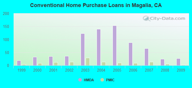
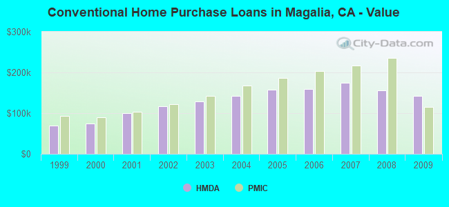
B) Conventional Home Purchase Loans
C) Refinancings
D) Home Improvement Loans
F) Non-occupant Loans on < 5 Family Dwellings (A B C & D)
G) Loans On Manufactured Home Dwelling (A B C & D)
Number
Average Value
Number
Average Value
Number
Average Value
Number
Average Value
Number
Average Value
Number
Average Value
LOANS ORIGINATED
25
$132,659
27
$142,815
75
$162,699
5
$94,544
15
$139,211
17
$107,742
APPLICATIONS APPROVED, NOT ACCEPTED
2
$176,325
3
$106,957
9
$166,552
1
$7,530
1
$171,400
2
$87,435
APPLICATIONS DENIED
7
$144,434
3
$104,680
44
$189,028
1
$221,510
6
$129,862
4
$99,792
APPLICATIONS WITHDRAWN
3
$120,007
4
$111,570
30
$174,876
1
$26,230
3
$195,117
5
$123,574
FILES CLOSED FOR INCOMPLETENESS
1
$231,990
0
$0
3
$172,687
0
$0
0
$0
1
$49,550
Aggregated Statistics For Year 2008 (Based on 2 partial tracts)
A) FHA, FSA/RHS & VA Home Purchase Loans
B) Conventional Home Purchase Loans
C) Refinancings
D) Home Improvement Loans
F) Non-occupant Loans on < 5 Family Dwellings (A B C & D)
G) Loans On Manufactured Home Dwelling (A B C & D)
Number
Average Value
Number
Average Value
Number
Average Value
Number
Average Value
Number
Average Value
Number
Average Value
LOANS ORIGINATED
17
$159,001
25
$156,604
59
$161,189
8
$64,725
15
$137,707
20
$114,308
APPLICATIONS APPROVED, NOT ACCEPTED
2
$104,920
4
$108,365
12
$161,259
2
$24,510
3
$110,167
8
$111,655
APPLICATIONS DENIED
3
$139,593
6
$149,920
65
$173,251
12
$66,352
5
$102,820
22
$96,881
APPLICATIONS WITHDRAWN
5
$191,126
8
$136,022
26
$175,616
3
$114,540
5
$121,840
5
$154,344
FILES CLOSED FOR INCOMPLETENESS
0
$0
2
$230,205
5
$184,822
2
$101,715
0
$0
0
$0
Aggregated Statistics For Year 2007 (Based on 2 partial tracts)
A) FHA, FSA/RHS & VA Home Purchase Loans
B) Conventional Home Purchase Loans
C) Refinancings
D) Home Improvement Loans
F) Non-occupant Loans on < 5 Family Dwellings (A B C & D)
G) Loans On Manufactured Home Dwelling (A B C & D)
Number
Average Value
Number
Average Value
Number
Average Value
Number
Average Value
Number
Average Value
Number
Average Value
LOANS ORIGINATED
10
$160,132
66
$174,655
95
$174,771
20
$93,280
19
$202,308
35
$118,861
APPLICATIONS APPROVED, NOT ACCEPTED
0
$0
8
$198,654
16
$165,452
2
$37,620
2
$260,555
4
$108,142
APPLICATIONS DENIED
2
$155,080
18
$186,996
74
$192,613
15
$106,865
17
$198,471
18
$119,414
APPLICATIONS WITHDRAWN
1
$82,770
6
$211,080
43
$186,441
4
$109,802
3
$173,740
6
$117,313
FILES CLOSED FOR INCOMPLETENESS
1
$95,010
1
$29,730
14
$216,541
3
$101,950
2
$149,195
2
$143,375
Aggregated Statistics For Year 2006 (Based on 2 partial tracts)
A) FHA, FSA/RHS & VA Home Purchase Loans
B) Conventional Home Purchase Loans
C) Refinancings
D) Home Improvement Loans
E) Loans on Dwellings For 5+ Families
F) Non-occupant Loans on < 5 Family Dwellings (A B C & D)
G) Loans On Manufactured Home Dwelling (A B C & D)
Number
Average Value
Number
Average Value
Number
Average Value
Number
Average Value
Number
Average Value
Number
Average Value
Number
Average Value
LOANS ORIGINATED
3
$242,097
88
$160,129
142
$186,247
28
$101,770
1
$134,070
24
$190,324
40
$112,172
APPLICATIONS APPROVED, NOT ACCEPTED
0
$0
17
$125,068
29
$179,119
2
$118,720
0
$0
3
$208,580
6
$98,202
APPLICATIONS DENIED
1
$104,340
24
$166,471
96
$183,250
25
$87,404
0
$0
9
$240,763
24
$117,283
APPLICATIONS WITHDRAWN
0
$0
13
$161,241
69
$188,119
8
$119,436
0
$0
4
$172,182
10
$115,831
FILES CLOSED FOR INCOMPLETENESS
1
$104,340
6
$214,972
9
$245,263
1
$132,580
0
$0
1
$446,720
3
$127,217
Aggregated Statistics For Year 2005 (Based on 2 partial tracts)
A) FHA, FSA/RHS & VA Home Purchase Loans
B) Conventional Home Purchase Loans
C) Refinancings
D) Home Improvement Loans
F) Non-occupant Loans on < 5 Family Dwellings (A B C & D)
G) Loans On Manufactured Home Dwelling (A B C & D)
Number
Average Value
Number
Average Value
Number
Average Value
Number
Average Value
Number
Average Value
Number
Average Value
LOANS ORIGINATED
8
$170,715
154
$158,269
170
$172,377
29
$98,394
37
$157,889
43
$105,010
APPLICATIONS APPROVED, NOT ACCEPTED
0
$0
14
$164,153
28
$181,851
4
$112,038
10
$161,636
7
$98,181
APPLICATIONS DENIED
4
$179,992
32
$151,111
99
$146,163
17
$77,055
9
$177,328
35
$101,472
APPLICATIONS WITHDRAWN
2
$163,505
21
$160,902
93
$155,467
9
$92,978
13
$140,684
16
$105,537
FILES CLOSED FOR INCOMPLETENESS
0
$0
1
$129,470
22
$146,675
2
$118,015
1
$167,320
5
$92,098
Aggregated Statistics For Year 2004 (Based on 2 partial tracts)
A) FHA, FSA/RHS & VA Home Purchase Loans
B) Conventional Home Purchase Loans
C) Refinancings
D) Home Improvement Loans
F) Non-occupant Loans on < 5 Family Dwellings (A B C & D)
G) Loans On Manufactured Home Dwelling (A B C & D)
Number
Average Value
Number
Average Value
Number
Average Value
Number
Average Value
Number
Average Value
Number
Average Value
LOANS ORIGINATED
8
$133,970
140
$142,827
159
$142,662
37
$89,102
47
$139,003
48
$100,168
APPLICATIONS APPROVED, NOT ACCEPTED
0
$0
16
$158,312
34
$140,649
6
$59,975
6
$136,630
9
$77,948
APPLICATIONS DENIED
4
$138,440
22
$144,255
96
$128,240
15
$42,412
17
$131,035
28
$88,411
APPLICATIONS WITHDRAWN
1
$184,780
20
$144,959
53
$141,318
7
$110,640
3
$143,327
10
$94,474
FILES CLOSED FOR INCOMPLETENESS
0
$0
5
$121,046
14
$127,876
1
$11,660
2
$78,990
3
$79,343
Aggregated Statistics For Year 2003 (Based on 2 partial tracts)
A) FHA, FSA/RHS & VA Home Purchase Loans
B) Conventional Home Purchase Loans
C) Refinancings
D) Home Improvement Loans
F) Non-occupant Loans on < 5 Family Dwellings (A B C & D)
Number
Average Value
Number
Average Value
Number
Average Value
Number
Average Value
Number
Average Value
LOANS ORIGINATED
9
$135,733
123
$129,525
341
$112,762
15
$31,143
47
$118,326
APPLICATIONS APPROVED, NOT ACCEPTED
0
$0
13
$119,380
48
$109,364
1
$36,900
7
$120,447
APPLICATIONS DENIED
2
$95,885
22
$112,073
103
$108,986
17
$24,436
11
$101,729
APPLICATIONS WITHDRAWN
1
$51,300
13
$146,277
83
$123,980
2
$33,970
5
$83,946
FILES CLOSED FOR INCOMPLETENESS
0
$0
2
$108,130
17
$147,136
0
$0
2
$89,480
Aggregated Statistics For Year 2002 (Based on 1 partial tract)
A) FHA, FSA/RHS & VA Home Purchase Loans
B) Conventional Home Purchase Loans
C) Refinancings
D) Home Improvement Loans
F) Non-occupant Loans on < 5 Family Dwellings (A B C & D)
Number
Average Value
Number
Average Value
Number
Average Value
Number
Average Value
Number
Average Value
LOANS ORIGINATED
3
$124,770
36
$116,112
63
$103,114
3
$40,350
7
$110,679
APPLICATIONS APPROVED, NOT ACCEPTED
0
$0
3
$132,327
7
$120,616
0
$0
0
$0
APPLICATIONS DENIED
0
$0
7
$105,793
23
$94,070
4
$20,175
3
$75,837
APPLICATIONS WITHDRAWN
0
$0
4
$109,430
15
$95,409
1
$27,290
2
$103,185
FILES CLOSED FOR INCOMPLETENESS
0
$0
2
$92,615
3
$90,053
0
$0
0
$0
Aggregated Statistics For Year 2001 (Based on 1 partial tract)
A) FHA, FSA/RHS & VA Home Purchase Loans
B) Conventional Home Purchase Loans
C) Refinancings
D) Home Improvement Loans
F) Non-occupant Loans on < 5 Family Dwellings (A B C & D)
Number
Average Value
Number
Average Value
Number
Average Value
Number
Average Value
Number
Average Value
LOANS ORIGINATED
5
$93,770
35
$100,028
51
$104,906
8
$19,408
12
$100,975
APPLICATIONS APPROVED, NOT ACCEPTED
0
$0
3
$55,980
7
$386,880
1
$76,860
2
$1,008,595
APPLICATIONS DENIED
2
$68,405
3
$87,107
16
$70,808
5
$50,728
1
$60,340
APPLICATIONS WITHDRAWN
0
$0
3
$45,987
13
$76,032
2
$16,910
2
$56,875
FILES CLOSED FOR INCOMPLETENESS
0
$0
1
$55,720
2
$130,085
0
$0
0
$0
Aggregated Statistics For Year 2000 (Based on 1 partial tract)
A) FHA, FSA/RHS & VA Home Purchase Loans
B) Conventional Home Purchase Loans
C) Refinancings
D) Home Improvement Loans
F) Non-occupant Loans on < 5 Family Dwellings (A B C & D)
Number
Average Value
Number
Average Value
Number
Average Value
Number
Average Value
Number
Average Value
LOANS ORIGINATED
8
$88,052
33
$74,927
15
$73,401
4
$25,652
8
$78,878
APPLICATIONS APPROVED, NOT ACCEPTED
0
$0
4
$56,012
4
$39,488
2
$15,755
1
$75,320
APPLICATIONS DENIED
1
$104,910
7
$68,954
12
$58,446
2
$23,060
1
$44,580
APPLICATIONS WITHDRAWN
0
$0
3
$97,870
8
$65,908
0
$0
2
$80,705
FILES CLOSED FOR INCOMPLETENESS
0
$0
0
$0
2
$67,635
0
$0
1
$49,190
Aggregated Statistics For Year 1999 (Based on 1 partial tract)
A) FHA, FSA/RHS & VA Home Purchase Loans
B) Conventional Home Purchase Loans
C) Refinancings
D) Home Improvement Loans
F) Non-occupant Loans on < 5 Family Dwellings (A B C & D)
Detailed PMIC statistics for the following Tracts:0017.02
, 0018.00
2003 - 2018 National Fire Incident Reporting System (NFIRS) incidents
Based on the data from the years 2003 - 2018 the average number of fires per year is 12. The highest number of reported fire incidents - 63 took place in 2003, and the least - 0 in 2012. The data has a dropping trend.
When looking into fire subcategories, the most reports belonged to: Outside Fires (48.0%), and Structure Fires (36.4%).
Fire incident types reported to NFIRS in Magalia, CA
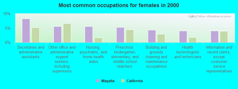
#53 on the list of "Top 101 cities with largest percentage of females in industries: health care and social assistance (population 5,000+)"
#12 on the list of "Top 101 counties with the lowest lead air pollution readings in 2012 (µg/m3)"
#15 on the list of "Top 101 counties with the highest carbon monoxide air pollution readings in 2012 (ppm)"
#17 on the list of "Top 101 counties with the highest lead air pollution readings in 2012 (µg/m3)"
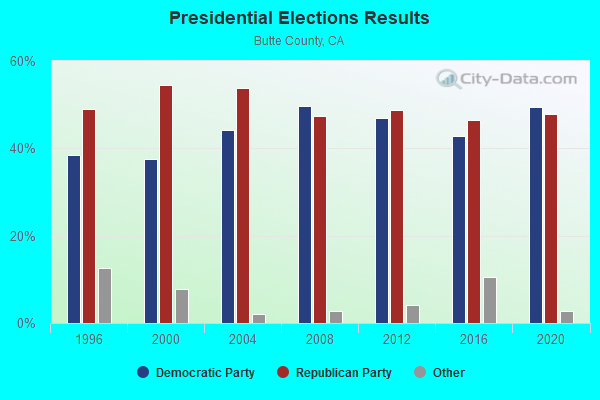
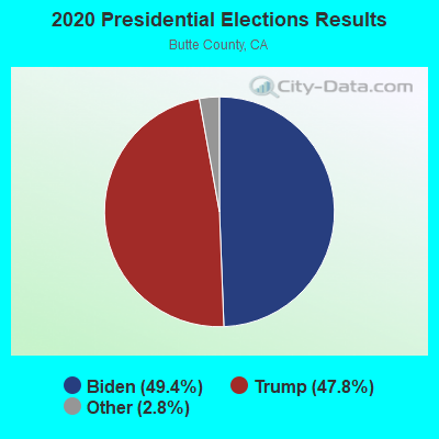
#18 on the list of "Top 101 counties with highest percentage of residents voting for 3rd party candidates in the 2012 Presidential Election (pop. 50,000+)"
#37 on the list of "Top 101 counties with the lowest percentage of residents relocating to foreign countries in 2011"


 Recent articles from our blog. Our writers, many of them Ph.D. graduates or candidates, create easy-to-read articles on a wide variety of topics.

 (13.7 miles


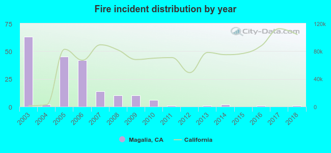 Based on the data from the years 2003 - 2018 the average number of fires per year is 12. The highest number of reported fire incidents - 63 took place in 2003, and the least - 0 in 2012. The data has a dropping trend.
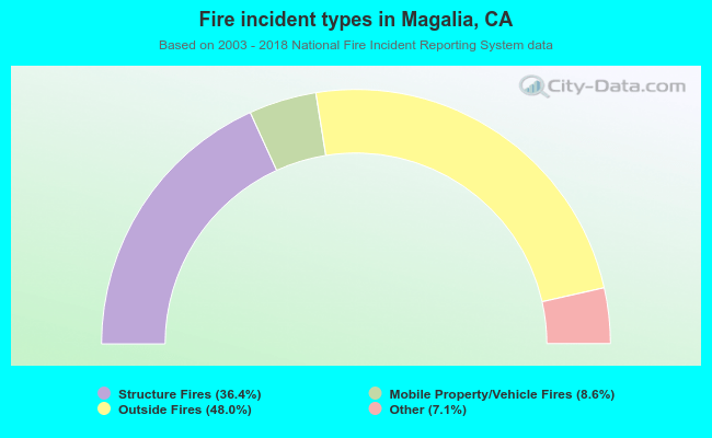 When looking into fire subcategories, the most reports belonged to: Outside Fires (48.0%), and Structure Fires (36.4%).