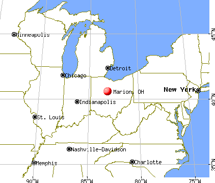
Marion, Ohio

Marion: Harding Memorial in the Fall

Marion: Marion, Ohio:Marion County Courthouse

Marion: QUARRY PARK OUTSKIRTS MARION OHIO

Marion: Marion,Ohio:President Warren G. Harding Memorial

Marion: Marion,Ohio:Mural

Marion: QUARRY PARK OUTSKIRTS MARION OHIO

Marion: Harding Memorial
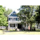
Marion: President Hardings home

Marion: Delaware Dam

Marion: Quarry Park

Marion: Harding Memorial in Marion, Ohio
- see
13
more - add
your
Submit your own pictures of this city and show them to the world
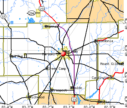
- OSM Map
- General Map
- Google Map
- MSN Map
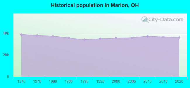
Population change since 2000: +0.0%
 |
| Males: 19,508 | |
| Females: 15,819 |
| Median resident age: | 36.8 years |
| Ohio median age: | 39.9 years |
Zip codes: 43302.
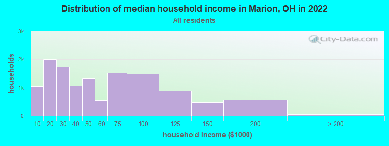
| Marion: | $46,183 |
| OH: | $65,720 |
Estimated per capita income in 2022: $19,167 (it was $16,247 in 2000)
Marion city income, earnings, and wages data
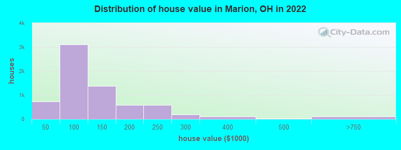
Estimated median house or condo value in 2022: $102,135 (it was $66,200 in 2000)
| Marion: | $102,135 |
| OH: | $204,100 |
Median gross rent in 2022: $773.
(19.1% for White Non-Hispanic residents, 25.9% for Black residents, 56.9% for Hispanic or Latino residents, 86.7% for American Indian residents, 41.9% for other race residents, 34.7% for two or more races residents)
Detailed information about poverty and poor residents in Marion, OH


- 28,25478.8%White alone
- 3,0418.5%Black alone
- 2,7257.6%Two or more races
- 1,6974.7%Hispanic
- 2630.7%Other race alone
- 490.1%American Indian alone
- 490.1%Asian alone
- 240.07%Native Hawaiian and Other
Pacific Islander alone
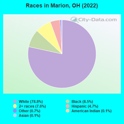
Races in Marion detailed stats: ancestries, foreign born residents, place of birth
According to our research of Ohio and other state lists, there were 125 registered sex offenders living in Marion, Ohio as of April 27, 2024.
The ratio of all residents to sex offenders in Marion is 293 to 1.
Type |
2009 |
2010 |
2011 |
2012 |
2013 |
2014 |
2015 |
2016 |
2017 |
2018 |
2019 |
2020 |
2021 |
2022 |
|---|---|---|---|---|---|---|---|---|---|---|---|---|---|---|
| Murders (per 100,000) | 1 (2.8) | 1 (2.7) | 3 (8.1) | 2 (5.5) | 1 (2.7) | 2 (5.4) | 1 (2.7) | 1 (2.8) | 3 (8.3) | 1 (2.8) | 0 (0.0) | 2 (5.6) | 2 (5.7) | 4 (11.2) |
| Rapes (per 100,000) | 10 (28.0) | 18 (48.9) | 15 (40.7) | 14 (38.2) | 29 (78.5) | 33 (89.8) | 46 (125.8) | 22 (60.6) | 40 (110.4) | 39 (108.7) | 31 (86.1) | 35 (97.8) | 25 (70.6) | 35 (97.8) |
| Robberies (per 100,000) | 30 (84.1) | 35 (95.0) | 53 (143.8) | 51 (139.0) | 66 (178.7) | 39 (106.1) | 42 (114.8) | 37 (102.0) | 29 (80.0) | 26 (72.5) | 27 (75.0) | 11 (30.7) | 22 (62.2) | 5 (14.0) |
| Assaults (per 100,000) | 18 (50.4) | 37 (100.4) | 28 (76.0) | 33 (90.0) | 39 (105.6) | 31 (84.3) | 44 (120.3) | 47 (129.6) | 31 (85.6) | 35 (97.5) | 30 (83.3) | 32 (89.4) | 29 (81.9) | 37 (103.4) |
| Burglaries (per 100,000) | 464 (1,300) | 555 (1,507) | 869 (2,357) | 873 (2,380) | 870 (2,355) | 633 (1,722) | 764 (2,089) | 517 (1,425) | 322 (888.8) | 288 (802.6) | 253 (702.8) | 156 (435.9) | 140 (395.6) | 146 (408.1) |
| Thefts (per 100,000) | 1,117 (3,130) | 1,345 (3,651) | 1,594 (4,324) | 1,023 (2,788) | 1,048 (2,837) | 889 (2,418) | 916 (2,504) | 772 (2,128) | 652 (1,800) | 598 (1,666) | 596 (1,656) | 471 (1,316) | 453 (1,280) | 468 (1,308) |
| Auto thefts (per 100,000) | 31 (86.9) | 48 (130.3) | 50 (135.6) | 48 (130.8) | 58 (157.0) | 39 (106.1) | 48 (131.2) | 31 (85.5) | 32 (88.3) | 54 (150.5) | 51 (141.7) | 58 (162.1) | 59 (166.7) | 21 (58.7) |
| Arson (per 100,000) | 7 (19.6) | 7 (19.0) | 14 (38.0) | 12 (32.7) | 12 (32.5) | 10 (27.2) | 11 (30.1) | 9 (24.8) | 12 (33.1) | 8 (22.3) | 6 (16.7) | 8 (22.4) | 5 (14.1) | 6 (16.8) |
| City-Data.com crime index | 286.5 | 355.1 | 456.0 | 389.7 | 433.9 | 357.1 | 421.5 | 302.2 | 287.3 | 268.6 | 234.8 | 212.7 | 195.1 | 211.1 |
The City-Data.com crime index weighs serious crimes and violent crimes more heavily. Higher means more crime, U.S. average is 246.1. It adjusts for the number of visitors and daily workers commuting into cities.
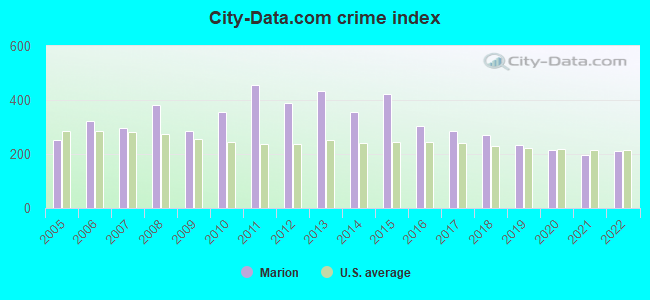
Crime rate in Marion detailed stats: murders, rapes, robberies, assaults, burglaries, thefts, arson
Full-time law enforcement employees in 2011, including police officers: 70 (56 officers - 55 male; 1 female).
| Officers per 1,000 residents here: | 1.52 |
| Ohio average: | 2.11 |
 Recent articles from our blog. Our writers, many of them Ph.D. graduates or candidates, create easy-to-read articles on a wide variety of topics.

 | Cleveland hospitals may be "overrun" by omicron cases (59 replies) |
| How did Biden not win Ohio? (208 replies) |
| What's driving Columbus's (population) growth over Indianapolis? (35 replies) |
| McDonald's in Marion (1 reply) |
| Marion's vs LaRosa's Pizza (29 replies) |
| Ohio daily reports: hospitalizations and deaths (65 replies) |
Latest news from Marion, OH collected exclusively by city-data.com from local newspapers, TV, and radio stations
Ancestries: American (18.5%), English (13.0%), German (12.3%), Irish (6.9%), European (2.6%), Italian (2.5%).
Current Local Time: EST time zone
Elevation: 956 feet
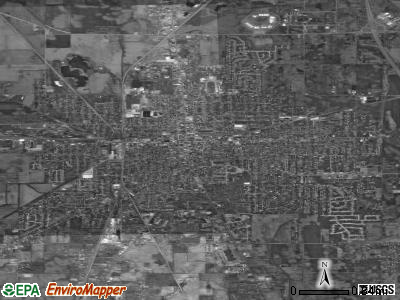
Land area: 11.3 square miles.
Population density: 3,114 people per square mile (average).
595 residents are foreign born
| This city: | 1.7% |
| Ohio: | 4.9% |
Median real estate property taxes paid for housing units with mortgages in 2022: $1,146 (1.0%)
Median real estate property taxes paid for housing units with no mortgage in 2022: $813 (1.0%)
Nearest city with pop. 50,000+: Columbus, OH  (41.9 miles , pop. 711,470).
Nearest city with pop. 1,000,000+: Chicago, IL (252.2 miles , pop. 2,896,016).
Nearest cities:
), ), ), ), ), Latitude: 40.59 N, Longitude: 83.13 W
Daytime population change due to commuting: -345 (-1.0%)
Workers who live and work in this city: 5,408 (41.3%)
Area code: 740
Marion, Ohio accommodation & food services, waste management - Economy and Business Data
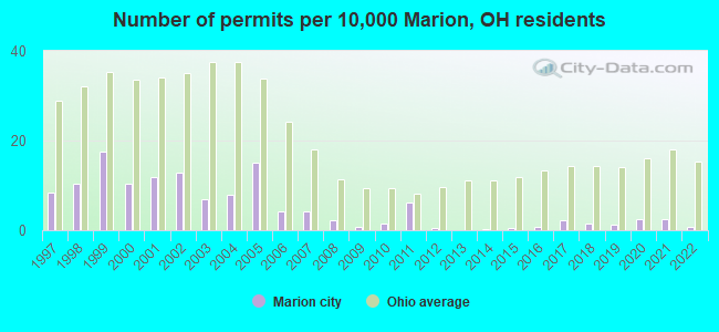
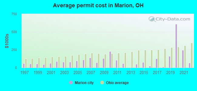
Single-family new house construction building permits:
- 2022: 3 buildings, average cost: $66,700
- 2021: 9 buildings, average cost: $244,800
- 2020: 9 buildings, average cost: $611,100
- 2019: 4 buildings, average cost: $162,500
- 2018: 5 buildings, average cost: $13,000
- 2017: 8 buildings, average cost: $126,900
- 2016: 3 buildings, average cost: $24,700
- 2015: 2 buildings, average cost: $75,000
- 2014: 1 building, cost: $50,000
- 2012: 2 buildings, average cost: $60,000
- 2011: 22 buildings, average cost: $107,400
- 2010: 5 buildings, average cost: $229,800
- 2009: 3 buildings, average cost: $133,300
- 2008: 8 buildings, average cost: $73,500
- 2007: 15 buildings, average cost: $140,000
- 2006: 15 buildings, average cost: $108,900
- 2005: 53 buildings, average cost: $99,300
- 2004: 28 buildings, average cost: $81,900
- 2003: 24 buildings, average cost: $81,800
- 2002: 45 buildings, average cost: $87,800
- 2001: 42 buildings, average cost: $65,200
- 2000: 37 buildings, average cost: $44,700
- 1999: 62 buildings, average cost: $57,200
- 1998: 37 buildings, average cost: $56,500
- 1997: 30 buildings, average cost: $59,900
| Here: | 3.5% |
| Ohio: | 3.1% |
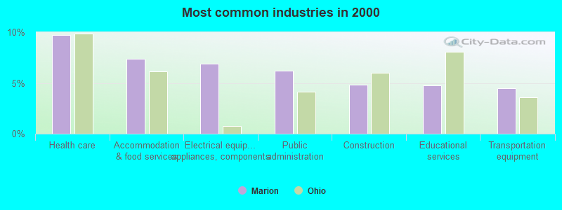
- Health care (9.7%)
- Accommodation & food services (7.4%)
- Electrical equipment, appliances, components (6.9%)
- Public administration (6.2%)
- Construction (4.8%)
- Educational services (4.7%)
- Transportation equipment (4.5%)
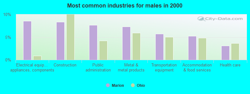
- Electrical equipment, appliances, components (8.6%)
- Construction (8.4%)
- Public administration (7.7%)
- Metal & metal products (7.3%)
- Transportation equipment (5.7%)
- Accommodation & food services (5.3%)
- Health care (3.1%)
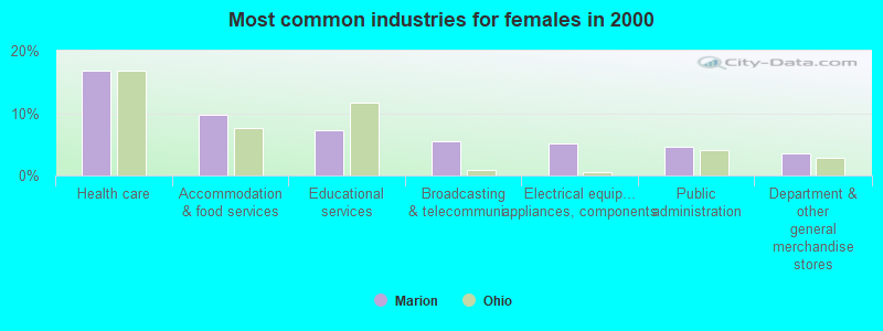
- Health care (16.8%)
- Accommodation & food services (9.7%)
- Educational services (7.3%)
- Broadcasting & telecommunications (5.5%)
- Electrical equipment, appliances, components (5.1%)
- Public administration (4.7%)
- Department & other general merchandise stores (3.6%)
- Other production occupations, including supervisors (7.6%)
- Assemblers and fabricators (5.4%)
- Laborers and material movers, hand (4.8%)
- Metal workers and plastic workers (4.1%)
- Building and grounds cleaning and maintenance occupations (3.2%)
- Other sales and related occupations, including supervisors (3.2%)
- Retail sales workers, except cashiers (3.1%)
- Other production occupations, including supervisors (8.6%)
- Metal workers and plastic workers (7.0%)
- Laborers and material movers, hand (6.8%)
- Assemblers and fabricators (5.6%)
- Electrical equipment mechanics and other installation, maintenance, and repair workers, including supervisors (5.1%)
- Other material moving workers, except laborers (4.2%)
- Driver/sales workers and truck drivers (4.2%)

- Other production occupations, including supervisors (6.4%)
- Secretaries and administrative assistants (5.4%)
- Assemblers and fabricators (5.2%)
- Customer service representatives (4.8%)
- Other office and administrative support workers, including supervisors (4.2%)
- Nursing, psychiatric, and home health aides (4.0%)
- Retail sales workers, except cashiers (3.9%)
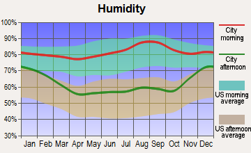
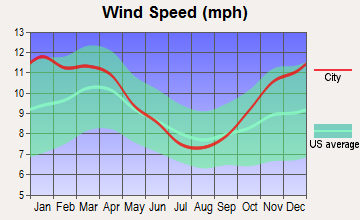
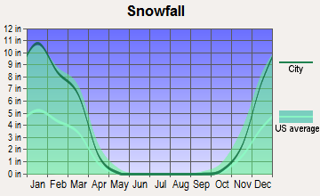
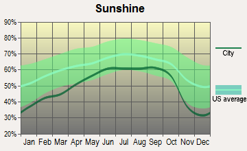
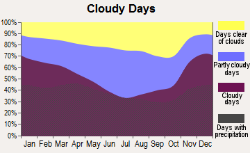
Average climate in Marion, Ohio
Based on data reported by over 4,000 weather stations
|
|

Tornado activity:
Marion-area historical tornado activity is near Ohio state average. It is 32% greater than the overall U.S. average.
On 4/11/1965, a category F4 (max. wind speeds 207-260 mph) tornado 35.3 miles away from the Marion city center killed 13 people and injured 104 people and caused between $500,000 and $5,000,000 in damages.
On 6/13/1981, a category F3 (max. wind speeds 158-206 mph) tornado 13.3 miles away from the city center killed 4 people and injured 56 people and caused between $5,000,000 and $50,000,000 in damages.
Earthquake activity:
Marion-area historical earthquake activity is significantly above Ohio state average. It is 24% smaller than the overall U.S. average.On 9/25/1998 at 19:52:52, a magnitude 5.2 (4.8 MB, 4.3 MS, 5.2 LG, 4.5 MW, Depth: 3.1 mi, Class: Moderate, Intensity: VI - VII) earthquake occurred 155.6 miles away from Marion center
On 1/31/1986 at 16:46:43, a magnitude 5.0 (5.0 MB) earthquake occurred 124.3 miles away from the city center
On 7/27/1980 at 18:52:21, a magnitude 5.2 (5.1 MB, 4.7 MS, 5.0 UK, 5.2 UK) earthquake occurred 170.4 miles away from the city center
On 7/12/1986 at 08:19:37, a magnitude 4.5 (4.5 MB, Class: Light, Intensity: IV - V) earthquake occurred 65.5 miles away from Marion center
On 8/23/2011 at 17:51:04, a magnitude 5.8 (5.8 MW, Depth: 3.7 mi) earthquake occurred 333.9 miles away from Marion center
On 4/18/2008 at 09:36:59, a magnitude 5.4 (5.1 MB, 4.8 MS, 5.4 MW, 5.2 MW) earthquake occurred 293.7 miles away from the city center
Magnitude types: regional Lg-wave magnitude (LG), body-wave magnitude (MB), surface-wave magnitude (MS), moment magnitude (MW)
Natural disasters:
The number of natural disasters in Marion County (9) is smaller than the US average (15).Major Disasters (Presidential) Declared: 3
Emergencies Declared: 5
Causes of natural disasters: Floods: 3, Snows: 2, Snowstorms: 2, Storms: 2, Blizzard: 1, Hurricane: 1, Mudslide: 1, Winter Storm: 1, Other: 1 (Note: some incidents may be assigned to more than one category).
Hospitals in Marion:
- MARION GENERAL HOSPITAL (Voluntary non-profit - Private, provides emergency services, 1000 MCKINLEY PARK DRIVE)
- MARION GENERAL HOSPITAL HOSPICE (458 E CENTER STREET)
- MEDCENTER HOSPITAL INC (provides emergency services, 1050 DELAWARE AVE)
- VOCA MARION GROUP HOME (340 JAMESWAY)
Nursing Homes in Marion:
- EAST LAWN MANOR (1422 MT VERNON AVE)
- HARDING POINTE (340 OAK STREET)
- HEARTLAND OF MARION (400 BARKS ROAD WEST)
- KINDRED NURSING AND REHABILITATION-COMMUNITY (175 COMMUNITY DRIVE)
- MARION MANOR NURSING HOME INC (195 EXECUTIVE DR)
- MARION POINTE (409 BELLFONTAINE AVENUE)
- MORNINGVIEW CARE CENTER OF MARION (677 W MARION CARDINGTON RD)
- MORNINGVIEW POINTE (677 MARION CARDINGTON ROAD W)
- PARTNERS OF MARION CARE AND REHABILITATION CENTER (524 JAMES WAY)
Dialysis Facilities in Marion:
Home Health Centers in Marion:
Airports and heliports located in Marion:
- Marion Municipal Airport (MNN) (Runways: 2, Air Taxi Ops: 5,500, Itinerant Ops: 15,000, Local Ops: 22,000, Military Ops: 150)
- Soltis Field Airport (75OI) (Runways: 1)
- Marion General Hospital Heliport (6OI4)
- Medcenter Hospital Heliport (20OI)
- Sheriff's Heliport (OI90)
Colleges/Universities in Marion:
- Marion Technical College (Full-time enrollment: 1,752; Location: 1467 Mount Vernon Ave; Public; Website: www.mtc.edu)
- Ohio State University-Marion Campus (Full-time enrollment: 1,064; Location: 1465 Mount Vernon Ave; Public; Website: osumarion.osu.edu/; Offers Master's degree)
- Tri-Rivers Career Center (Full-time enrollment: 130; Location: 2222 Marion - Mt. Gilead Rd; Public; Website: www.tririvers.com)
Colleges/universities with over 2000 students nearest to Marion:
- Otterbein University (about 34 miles; Westerville, OH; Full-time enrollment: 2,933)
- Tiffin University (about 37 miles; Tiffin, OH; FT enrollment: 4,927)
- Ohio Northern University (about 39 miles; Ada, OH; FT enrollment: 2,474)
- Ohio State University-Main Campus (about 42 miles; Columbus, OH; FT enrollment: 50,395)
- Ohio Dominican University (about 43 miles; Columbus, OH; FT enrollment: 2,045)
- The University of Findlay (about 43 miles; Findlay, OH; FT enrollment: 3,649)
- Columbus State Community College (about 44 miles; Columbus, OH; FT enrollment: 24,488)
Public high schools in Marion:
- TRECA DIGITAL ACADEMY (Students: 1,690, Location: 100 EXECUTIVE DR, Grades: KG-12, Charter school)
- HARDING HIGH SCHOOL (Students: 1,294, Location: 1500 HARDING HWY E, Grades: 9-12)
- ELGIN HIGH SCHOOL (Students: 454, Location: 1150 KEENER RD S, Grades: 9-12)
- PLEASANT HIGH SCHOOL (Students: 435, Location: 1101 OWENS RD W, Grades: 9-12)
- MARION CITY DIGITAL ACADEMY (Students: 152, Location: 360 PENNSYLVANIA AVE, Grades: KG-12, Charter school)
- RUSHMORE ACADEMY (Location: 910 E CHURCH ST, Grades: 9-12, Charter school)
- PLEASANT EDUCATION ACADEMY (Location: 1107 OWENS RD W, Grades: 9-12, Charter school)
- TRI-RIVERS CAREER CENTER (Location: 2222 MARION MOUNT GILEAD RD, Grades: PK-12)
Private high school in Marion:
Biggest public elementary/middle schools in Marion:
- ULYSSES S. GRANT MIDDLE SCHOOL (Students: 1,020, Location: 420 PRESIDENTIAL DR, Grades: 6-8)
- WILLIAM H. TAFT ELEMENTARY SCHOOL (Students: 487, Location: 1000 ROBINSON ST, Grades: PK-5)
- WILLIAM MCKINLEY ELEMENTARY SCHOOL (Students: 420, Location: 925 CHATFIELD RD, Grades: PK-5)
- GEORGE WASHINGTON ELEMENTARY SCHOOL (Students: 410, Location: 400 PENNSYLVANIA AVE, Grades: PK-5)
- BENJAMIN HARRISON ELEMENTARY SCHOOL (Students: 337, Location: 625 BRIGHTWOOD DR, Grades: PK-5)
- PLEASANT ELEMENTARY SCHOOL (Students: 317, Location: 1105 OWENS RD W, Grades: KG-5)
- JAMES A. GARFIELD ELEMENTARY SCHOOL (Students: 308, Location: 1170 BROOKSIDE RD, Grades: PK-5)
- RUTHERFORD B. HAYES ELEMENTARY SCHOOL (Students: 242, Location: 750 SILVER ST, Grades: PK-5)
- ELGIN MIDDLE SCHOOL (Location: 1200 KEENER RD S, Grades: 6-8)
- ELGIN ELEMENTARY SCHOOL (Location: 1250 KEENER RD S, Grades: KG-5)
Private elementary/middle school in Marion:
User-submitted facts and corrections:
- could you add Word of Life Christian Center at 580 Silver Street to the local churches in Marion?
- Home of the largest microwave popcorn plant in the world - ConAgra Foods - making millions of bags of Orville Redenbacher and Act II popcorn every day.
Points of interest:
Notable locations in Marion: Marion County Fairgrounds (A), Stofcheck Ambulance Service (B), Rural / Metro Corporation (C), Marion City Fire Department Station 2 (D), Marion City Fire Department Station 3 (E), Marion Township Fire Department (F), Marion City Fire Department Station 1 (G), Harding Museum (H), Marion County Law Library (I), Marion Correctional Institution (J), Marion County Courthouse (K), Veterans Memorial Coliseum (L), Marion City Hall (M), Marion Public Library (N). Display/hide their locations on the map
Shopping Center: Delco Plaza Shopping Center (1). Display/hide its location on the map
Churches in Marion include: Salem United Church of Christ (A), Saint Pauls Episcopal Church (B), Saint Mary Catholic Church (C), First United Church of Christ (D), Calvary United Methodist Church (E), Central Christian Church (F), Christ Missionary Baptist Church (G), Church of Christ in Christian Union (H), Deliverance Temple Church of Christ (I). Display/hide their locations on the map
Cemeteries: Harding Memorial Park (1), Marion Cemetery (2), Old Marion Cemetery (3), Saint Marys Cemetery (4). Display/hide their locations on the map
Parks in Marion include: Sawyer-Ludwig Park (1), Roosevelt Park (2), McKinley Park (3), Lincoln Park (4). Display/hide their locations on the map
Tourist attractions: Harding Home & Museum (Cultural Attractions- Events- & Facilities; 380 Mount Vernon Avenue), Dp's Roleplaying (Arcades & Amusements; 188 1/2 Jefferson Street).
Hotels: Holiday Inn Express Hotel & Suites (1842 Marion Mount Gilead Road), Courtesy Budget Inn (1361 Harding Highway East), Comfort Inn Marion (256 Jamesway), Country Inn-Suites Marion (2091 Marion Mount Gilead Road).
Courts: Marion County - Juvenile Court- Ncorc (1440 Mount Vernon Avenue), Marion County - Juvenile Court (1440 Mount Vernon Avenue).
Birthplace of: Aubrey Huff - 2005 Major League Baseball player (Tampa Bay Devil Rays, born: Dec 20, 1976), Florence Harding - First Lady of the, George Pfann - Football player and coach, O. J. McDuffie - College football player, Ed McCants - College basketball player (Wisc. Milwaukee Panthers), George Hogan - Baseball player, Grant E. Mouser, Jr. - Politician, John A. Key - Politician, Norman Thomas - (1884-1968), social reformer, Robert B. Mautz - Lawyer.
Drinking water stations with addresses in Marion and their reported violations in the past:
NW OHIO CHRISTIAN YOUTH CAMP 3 PWS (Population served: 120, Groundwater):Past health violations:NW OHIO CHRISTIAN YOUTH CAMP 2 (Population served: 120, Groundwater):Past monitoring violations:
- MCL, Monthly (TCR) - In SEP-2013, Contaminant: Coliform. Follow-up actions: St Violation/Reminder Notice (SEP-20-2013), St Public Notif requested (SEP-20-2013), St Public Notif received (OCT-03-2013), St Compliance achieved (JUN-04-2014)
- MCL, Monthly (TCR) - In AUG-2013, Contaminant: Coliform. Follow-up actions: St Violation/Reminder Notice (AUG-23-2013), St Public Notif requested (AUG-23-2013), St Public Notif received (SEP-03-2013), St Compliance achieved (JUN-04-2014)
- MCL, Monthly (TCR) - Between JUL-2013 and SEP-2013, Contaminant: Coliform. Follow-up actions: St Violation/Reminder Notice (AUG-14-2013), St Public Notif requested (AUG-14-2013), St Public Notif received (AUG-22-2013), St Compliance achieved (JUN-04-2014)
- Monitoring, Source Water (GWR) - In SEP-18-2013, Contaminant: E. COLI. Follow-up actions: St Violation/Reminder Notice (OCT-03-2013), St Public Notif requested (OCT-03-2013), St Public Notif received (MAY-02-2014), St Compliance achieved (JUN-04-2014)
- Monitoring, Repeat Major (TCR) - In SEP-2013, Contaminant: Coliform (TCR). Follow-up actions: St Violation/Reminder Notice (OCT-03-2013), St Public Notif requested (OCT-03-2013), St Public Notif received (MAY-02-2014), St Compliance achieved (JUN-04-2014)
Past health violations:NW OHIO CHRISTIAN YOUTH (Population served: 120, Groundwater):
- MCL, Monthly (TCR) - Between JUL-2013 and SEP-2013, Contaminant: Coliform. Follow-up actions: St Public Notif requested (AUG-14-2013), St Violation/Reminder Notice (AUG-14-2013), St Compliance achieved (AUG-20-2013), St Public Notif received (AUG-22-2013)
Past health violations:TIMOTHY LUTHERAN CHURCH (Population served: 100, Groundwater):Past monitoring violations:
- MCL, Monthly (TCR) - Between JUL-2010 and SEP-2010, Contaminant: Coliform. Follow-up actions: St Public Notif requested (AUG-04-2010), St Violation/Reminder Notice (AUG-04-2010), St Compliance achieved (JUN-08-2011)
- MCL, Acute (TCR) - Between JUL-2006 and SEP-2006, Contaminant: Coliform. Follow-up actions: St Boil Water Order (SEP-08-2006), St Public Notif requested (SEP-08-2006), St Violation/Reminder Notice (SEP-08-2006), St Compliance achieved (APR-19-2007)
- Monitoring, Repeat Major (TCR) - Between JUL-2006 and SEP-2006, Contaminant: Coliform (TCR). Follow-up actions: St Public Notif requested (SEP-08-2006), St Violation/Reminder Notice (SEP-08-2006), St Compliance achieved (APR-19-2007), St Public Notif received (AUG-07-2007), St Compliance achieved (AUG-09-2007)
- 2 routine major monitoring violations
Past health violations:MARION INTERNATIONAL FARM / FLEA MKT PWS (Population served: 75, Groundwater):Past monitoring violations:
- MCL, Acute (TCR) - Between OCT-2005 and DEC-2005, Contaminant: Coliform. Follow-up actions: St Public Notif requested (OCT-13-2005), St Violation/Reminder Notice (OCT-13-2005), St Boil Water Order (OCT-13-2005), St Compliance achieved (APR-19-2007)
- MCL, Monthly (TCR) - Between OCT-2005 and DEC-2005, Contaminant: Coliform. Follow-up actions: St Public Notif requested (OCT-14-2005), St Violation/Reminder Notice (OCT-14-2005), St Compliance achieved (APR-19-2007)
- Monitoring, Repeat Major (TCR) - Between OCT-2005 and DEC-2005, Contaminant: Coliform (TCR). Follow-up actions: St Public Notif requested (OCT-13-2005), St Violation/Reminder Notice (OCT-13-2005), St Compliance achieved (APR-19-2007)
- One minor monitoring violation
Past health violations:STEPHEN J CHANEY VFW POST 7201 PWS (Population served: 75, Groundwater):Past monitoring violations:
- MCL, Monthly (TCR) - Between OCT-2005 and DEC-2005, Contaminant: Coliform. Follow-up actions: St Public Notif requested (OCT-13-2005), St Violation/Reminder Notice (OCT-13-2005), St Compliance achieved (APR-19-2007)
- Monitoring, Repeat Major (TCR) - Between JUL-2007 and SEP-2007, Contaminant: Coliform (TCR). Follow-up actions: St Public Notif requested (OCT-10-2007), St Violation/Reminder Notice (OCT-10-2007), St Public Notif received (OCT-17-2007), St Compliance achieved (MAR-19-2008)
- Monitoring, Repeat Major (TCR) - Between OCT-2006 and DEC-2006, Contaminant: Coliform (TCR). Follow-up actions: St Violation/Reminder Notice (OCT-18-2006), St Public Notif requested (OCT-18-2006), St Public Notif received (NOV-27-2006), St Compliance achieved (AUG-09-2007)
- 2 routine major monitoring violations
- One minor monitoring violation
- One regular monitoring violation
Past monitoring violations:TRINITY LUTHERAN EDUCATIONAL BUILDING (Population served: 75, Groundwater):
- 2 routine major monitoring violations
Past health violations:TRINITY LUTHERAN CHURCH (Population served: 70, Groundwater):Past monitoring violations:
- MCL, Monthly (TCR) - Between OCT-2006 and DEC-2006, Contaminant: Coliform. Follow-up actions: St Public Notif requested (OCT-13-2006), St Violation/Reminder Notice (OCT-13-2006), St Public Notif received (OCT-20-2006), St Compliance achieved (AUG-09-2007)
- 2 routine major monitoring violations
- One regular monitoring violation
Past monitoring violations:
- 2 routine major monitoring violations
- One regular monitoring violation
Drinking water stations with addresses in Marion that have no violations reported:
- AQUA OHIO - MARION (Population served: 41,925, Primary Water Source Type: Surface water)
- AQUA OHIO - SHEPARD HILLS PWS (Address: 1420 MARION CARDINGTON RD EAST , Population served: 802, Primary Water Source Type: Groundwater)
- ROUND UP, LLC (Population served: 800, Primary Water Source Type: Groundwater)
- AQUA OHIO - AUBURN LAKES PWS (Population served: 290, Primary Water Source Type: Groundwater)
- MARION TROTTERS FAMILY RESTAURANT PWS (Address: 822 DAVID , Population served: 30, Primary Water Source Type: Groundwater)
| This city: | 2.5 people |
| Ohio: | 2.4 people |
| This city: | 63.5% |
| Whole state: | 65.0% |
| This city: | 9.8% |
| Whole state: | 6.8% |
Likely homosexual households (counted as self-reported same-sex unmarried-partner households)
- Lesbian couples: 0.4% of all households
- Gay men: 0.2% of all households
People in group quarters in Marion in 2010:
- 4,594 people in state prisons
- 363 people in nursing facilities/skilled-nursing facilities
- 155 people in local jails and other municipal confinement facilities
- 46 people in emergency and transitional shelters (with sleeping facilities) for people experiencing homelessness
- 41 people in group homes intended for adults
- 35 people in residential treatment centers for adults
- 19 people in other noninstitutional facilities
- 14 people in workers' group living quarters and job corps centers
People in group quarters in Marion in 2000:
- 1,898 people in state prisons
- 201 people in nursing homes
- 76 people in other noninstitutional group quarters
- 13 people in hospitals/wards and hospices for chronically ill
- 13 people in other hospitals or wards for chronically ill
- 8 people in homes for the mentally ill
- 5 people in homes or halfway houses for drug/alcohol abuse
- 3 people in homes for the mentally retarded
Banks with most branches in Marion (2011 data):
- The Fahey Banking Company: Fahey Bank South Branch, at 127 North Main Street, East Side Branch, Northside Branch. Info updated 2006/11/03: Bank assets: $182.3 mil, Deposits: $133.5 mil, local headquarters, positive income, Commercial Lending Specialization, 4 total offices
- JPMorgan Chase Bank, National Association: Professional Park Branch, University Forum Branch, Marion Main Branch. Info updated 2011/11/10: Bank assets: $1,811,678.0 mil, Deposits: $1,190,738.0 mil, headquarters in Columbus, OH, positive income, International Specialization, 5577 total offices, Holding Company: Jpmorgan Chase & Co.
- The Commercial Savings Bank: Jamesway Branch at 279 Jamesway, branch established on 1996/05/29; Barks Road Branch at 195 Barks Road West, branch established on 2009/10/05. Info updated 2007/12/26: Bank assets: $288.1 mil, Deposits: $259.3 mil, headquarters in Upper Sandusky, OH, positive income, Commercial Lending Specialization, 9 total offices, Holding Company: Commercial Bancshares, Inc.
- The Ohio State Bank: Richland Road Branch at 220 Richland Road, branch established on 1996/12/06; at 111 South Main Street, branch established on 1988/08/23. Info updated 2012/04/03: Bank assets: $127.1 mil, Deposits: $102.4 mil, local headquarters, negative income in the last year, Commercial Lending Specialization, 5 total offices, Holding Company: Rbancshares, Inc.
- The Park National Bank: 1805 Walmart Branch at 1546 Marion Mt Gilead Road, branch established on 2004/08/10; 1810 Marion Barks Road Branch East at 128 Barks Rd, branch established on 2003/03/03. Info updated 2008/09/29: Bank assets: $6,281.7 mil, Deposits: $4,611.6 mil, headquarters in Newark, OH, positive income, Commercial Lending Specialization, 123 total offices, Holding Company: Park National Corporation
- The Huntington National Bank: Marion State Street Branch at 150 South State Street, branch established on 1985/06/30; Marion Mount Vernon Branch at 1200 Mount Vernon Avenue, branch established on 1888/01/01. Info updated 2012/04/02: Bank assets: $54,183.4 mil, Deposits: $44,300.3 mil, headquarters in Columbus, OH, positive income, Commercial Lending Specialization, 878 total offices, Holding Company: Huntington Bancshares Incorporated
- The First Citizens National Bank of Upper Sandusky: Marion Office Branch at 1240 Delaware Ave, branch established on 2002/09/20. Info updated 2006/11/03: Bank assets: $220.2 mil, Deposits: $170.7 mil, headquarters in Upper Sandusky, OH, positive income, 8 total offices
- Fifth Third Bank: Marion East Branch at 1607 Marion Mt Gilead Rd, branch established on 1900/01/01. Info updated 2009/10/05: Bank assets: $114,540.4 mil, Deposits: $89,689.1 mil, headquarters in Cincinnati, OH, positive income, Commercial Lending Specialization, 1378 total offices, Holding Company: Fifth Third Bancorp
- PNC Bank, National Association: Marion Plaza Branch at 1366 Mt. Vernon Avenue, branch established on 1958/12/04. Info updated 2012/03/20: Bank assets: $263,309.6 mil, Deposits: $197,343.0 mil, headquarters in Wilmington, DE, positive income, Commercial Lending Specialization, 3085 total offices, Holding Company: Pnc Financial Services Group, Inc., The
For population 15 years and over in Marion:
- Never married: 40.1%
- Now married: 32.7%
- Separated: 1.8%
- Widowed: 6.5%
- Divorced: 18.9%
For population 25 years and over in Marion:
- High school or higher: 87.1%
- Bachelor's degree or higher: 10.1%
- Graduate or professional degree: 2.5%
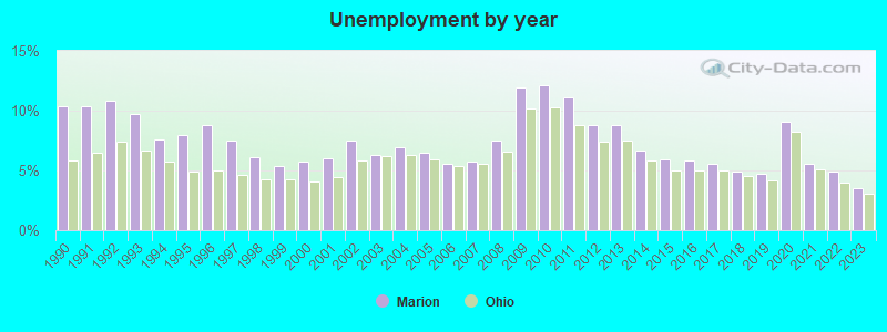
- Unemployed: 5.7%
- Mean travel time to work (commute): 17.8 minutes

| Here: | 9.6 |
| Ohio average: | 11.0 |
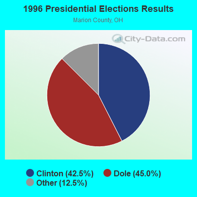
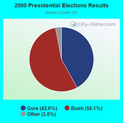
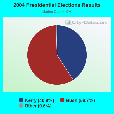
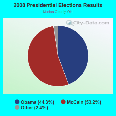
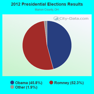
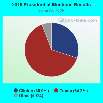
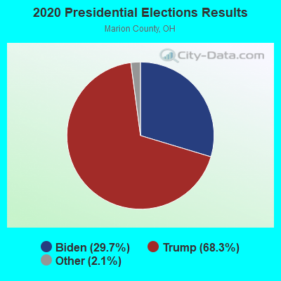
Graphs represent county-level data. Detailed 2008 Election Results
Religion statistics for Marion, OH (based on Marion County data)
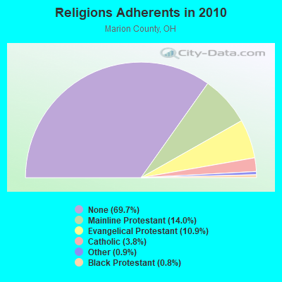
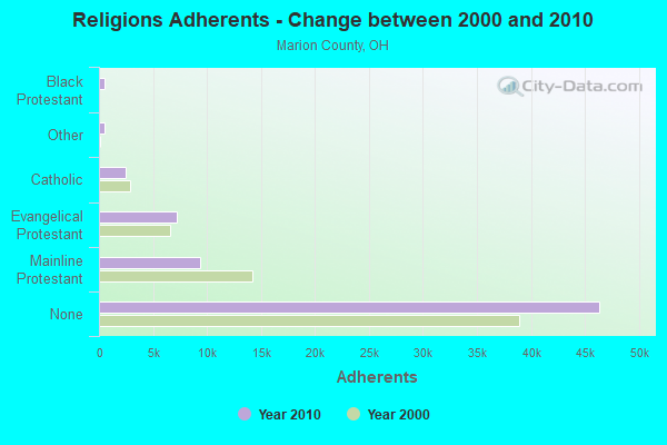
| Religion | Adherents | Congregations |
|---|---|---|
| Mainline Protestant | 9,328 | 38 |
| Evangelical Protestant | 7,229 | 49 |
| Catholic | 2,500 | 1 |
| Other | 566 | 3 |
| Black Protestant | 504 | 4 |
| None | 46,374 | - |
Food Environment Statistics:
| Marion County: | 1.83 / 10,000 pop. |
| Ohio: | 1.89 / 10,000 pop. |
| Marion County: | 0.15 / 10,000 pop. |
| State: | 0.13 / 10,000 pop. |
| Marion County: | 1.53 / 10,000 pop. |
| Ohio: | 1.25 / 10,000 pop. |
| Marion County: | 2.14 / 10,000 pop. |
| Ohio: | 2.93 / 10,000 pop. |
| This county: | 4.58 / 10,000 pop. |
| Ohio: | 6.25 / 10,000 pop. |
| Here: | 10.9% |
| Ohio: | 10.3% |
| Marion County: | 30.3% |
| Ohio: | 29.1% |
| Here: | 6.8% |
| State: | 11.9% |
Health and Nutrition:
| Marion: | 48.8% |
| Ohio: | 50.4% |
| Marion: | 45.3% |
| State: | 47.8% |
| This city: | 28.8 |
| State: | 28.7 |
| Marion: | 20.6% |
| Ohio: | 20.6% |
| Marion: | 10.4% |
| Ohio: | 10.4% |
| Marion: | 6.8 |
| Ohio: | 6.8 |
| Marion: | 34.3% |
| Ohio: | 34.3% |
| This city: | 56.0% |
| Ohio: | 57.0% |
| Marion: | 78.6% |
| Ohio: | 79.1% |
More about Health and Nutrition of Marion, OH Residents
| Local government employment and payroll (March 2022) | |||||
| Function | Full-time employees | Monthly full-time payroll | Average yearly full-time wage | Part-time employees | Monthly part-time payroll |
|---|---|---|---|---|---|
| Firefighters | 63 | $273,454 | $52,086 | 0 | $0 |
| Police Protection - Officers | 56 | $399,809 | $85,673 | 0 | $0 |
| Sewerage | 32 | $150,681 | $56,505 | 0 | $0 |
| Judicial and Legal | 22 | $96,096 | $52,416 | 0 | $0 |
| Streets and Highways | 21 | $105,403 | $60,230 | 0 | $0 |
| Solid Waste Management | 16 | $70,355 | $52,766 | 0 | $0 |
| Correction | 14 | $53,998 | $46,284 | 0 | $0 |
| Transit | 13 | $39,087 | $36,080 | 5 | $5,618 |
| Financial Administration | 10 | $42,439 | $50,927 | 1 | $750 |
| Other Government Administration | 9 | $14,765 | $19,687 | 11 | $8,518 |
| Parks and Recreation | 8 | $35,259 | $52,889 | 3 | $618 |
| Other and Unallocable | 8 | $35,982 | $53,973 | 0 | $0 |
| Welfare | 5 | $14,996 | $35,990 | 10 | $19,229 |
| Police - Other | 4 | $15,735 | $47,205 | 3 | $4,719 |
| Airports | 2 | $9,675 | $58,050 | 0 | $0 |
| Fire - Other | 1 | $3,919 | $47,028 | 0 | $0 |
| Totals for Government | 284 | $1,361,652 | $57,535 | 33 | $39,451 |
Marion government finances - Expenditure in 2018 (per resident):
- Construction - Sewerage: $1,225,000 ($34.68)
- Current Operations - Police Protection: $7,024,000 ($198.83)
Local Fire Protection: $6,485,000 ($183.57)
Sewerage: $4,433,000 ($125.48)
Regular Highways: $2,836,000 ($80.28)
Solid Waste Management: $2,397,000 ($67.85)
General - Other: $2,276,000 ($64.43)
Judicial and Legal Services: $1,850,000 ($52.37)
Parks and Recreation: $1,350,000 ($38.21)
Transit Utilities: $965,000 ($27.32)
Financial Administration: $638,000 ($18.06)
General Public Buildings: $557,000 ($15.77)
Health - Other: $471,000 ($13.33)
Air Transportation: $330,000 ($9.34)
Central Staff Services: $307,000 ($8.69)
- General - Interest on Debt: $1,104,000 ($31.25)
- Intergovernmental to State - Sewerage: $1,663,000 ($47.07)
General - Other: $142,000 ($4.02)
- Other Capital Outlay - Sewerage: $927,000 ($26.24)
Regular Highways: $490,000 ($13.87)
General - Other: $300,000 ($8.49)
Transit Utilities: $186,000 ($5.27)
Air Transportation: $51,000 ($1.44)
Judicial and Legal Services: $28,000 ($0.79)
Parks and Recreation: $12,000 ($0.34)
Solid Waste Management: $9,000 ($0.25)
Local Fire Protection: $4,000 ($0.11)
Police Protection: $4,000 ($0.11)
- Total Salaries and Wages: $19,526,000 ($552.72)
Marion government finances - Revenue in 2018 (per resident):
- Charges - Sewerage: $7,758,000 ($219.61)
Solid Waste Management: $2,548,000 ($72.13)
Other: $1,016,000 ($28.76)
Parks and Recreation: $431,000 ($12.20)
Regular Highways: $3,000 ($0.08)
- Miscellaneous - Fines and Forfeits: $1,693,000 ($47.92)
General Revenue - Other: $1,157,000 ($32.75)
Interest Earnings: $192,000 ($5.43)
Sale of Property: $6,000 ($0.17)
- Revenue - Transit Utilities: $121,000 ($3.43)
- State Intergovernmental - Highways: $1,773,000 ($50.19)
General Local Government Support: $1,357,000 ($38.41)
Other: $1,320,000 ($37.37)
Transit Utilities: $848,000 ($24.00)
Sewerage: $172,000 ($4.87)
- Tax - Individual Income: $18,096,000 ($512.24)
Property: $1,332,000 ($37.70)
Other License: $489,000 ($13.84)
Marion government finances - Debt in 2018 (per resident):
- Long Term Debt - Beginning Outstanding - Unspecified Public Purpose: $24,010,000 ($679.65)
Outstanding Unspecified Public Purpose: $22,716,000 ($643.02)
Retired Unspecified Public Purpose: $1,294,000 ($36.63)
Marion government finances - Cash and Securities in 2018 (per resident):
- Bond Funds - Cash and Securities: $1,712,000 ($48.46)
- Other Funds - Cash and Securities: $14,277,000 ($404.14)
- Sinking Funds - Cash and Securities: $296,000 ($8.38)
| Businesses in Marion, OH | ||||
| Name | Count | Name | Count | |
|---|---|---|---|---|
| ALDI | 1 | Long John Silver's | 1 | |
| Advance Auto Parts | 1 | Lowe's | 1 | |
| American Eagle Outfitters | 1 | Marriott | 1 | |
| Applebee's | 1 | MasterBrand Cabinets | 1 | |
| Arby's | 2 | Maurices | 1 | |
| Ashley Furniture | 1 | McDonald's | 3 | |
| AutoZone | 1 | Meijer | 1 | |
| Bath & Body Works | 1 | Menards | 1 | |
| Blockbuster | 1 | New Balance | 3 | |
| Buffalo Wild Wings | 1 | Nike | 6 | |
| Burger King | 2 | Office Depot | 1 | |
| CVS | 2 | Panera Bread | 1 | |
| Carson Pirie Scott | 1 | Papa John's Pizza | 1 | |
| Chevrolet | 1 | Payless | 1 | |
| Chipotle | 1 | Penske | 1 | |
| Circle K | 2 | Pizza Hut | 1 | |
| Cold Stone Creamery | 1 | RadioShack | 1 | |
| Comfort Inn | 1 | Red Lobster | 1 | |
| DHL | 1 | Rite Aid | 3 | |
| Dairy Queen | 1 | Ryan's Grill | 1 | |
| Dennys | 1 | SAS Shoes | 1 | |
| Domino's Pizza | 1 | SONIC Drive-In | 1 | |
| Fashion Bug | 1 | Sears | 2 | |
| FedEx | 5 | Shoe Carnival | 1 | |
| Finish Line | 1 | Starbucks | 2 | |
| Ford | 1 | Steak 'n Shake | 1 | |
| GNC | 3 | Subway | 5 | |
| GameStop | 2 | T-Mobile | 2 | |
| Goodwill | 2 | Taco Bell | 2 | |
| H&R Block | 2 | Tim Hortons | 1 | |
| Hobby Lobby | 1 | Toyota | 1 | |
| Holiday Inn | 1 | U-Haul | 4 | |
| Honda | 1 | UPS | 17 | |
| Hyundai | 1 | Verizon Wireless | 3 | |
| Jones New York | 1 | Walgreens | 2 | |
| KFC | 1 | Walmart | 1 | |
| Kohl's | 1 | Wendy's | 2 | |
| Kroger | 2 | White Castle | 1 | |
| La-Z-Boy | 1 | YMCA | 1 | |
| Little Caesars Pizza | 1 | |||
Strongest AM radio stations in Marion:
- WMRN (1490 AM; 1 kW; MARION, OH; Owner: CITICASTERS LICENSES, L.P.)
- WTVN (610 AM; 50 kW; COLUMBUS, OH; Owner: CITICASTERS LICENSES, L.P.)
- WRFD (880 AM; daytime; 23 kW; COLUMBUS-WORTHINGTON, OH; Owner: SALEM MEDIA OF OHIO, INC.)
- WKNR (850 AM; 50 kW; CLEVELAND, OH; Owner: CARON BROADCASTING, INC.)
- WDLR (1550 AM; 4 kW; DELAWARE, OH; Owner: THE FIFTEEN FIFTY CORPORATION)
- WLW (700 AM; 50 kW; CINCINNATI, OH; Owner: JACOR BROADCASTING CORPORATION)
- WTAM (1100 AM; 50 kW; CLEVELAND, OH; Owner: JACOR BROADCASTING CORPORATION)
- WJR (760 AM; 50 kW; DETROIT, MI; Owner: ABC, INC.)
- WHK (1220 AM; 50 kW; CLEVELAND, OH; Owner: CARON BROADCASTING, INC.)
- WFDF (910 AM; 50 kW; FLINT, MI; Owner: ABC, INC.)
- WDFN (1130 AM; 50 kW; DETROIT, MI; Owner: AMFM RADIO LICENSES, L.L.C.)
- WOSU (820 AM; 5 kW; COLUMBUS, OH; Owner: THE OHIO STATE UNIVERSITY)
- WCHB (1200 AM; 50 kW; TAYLOR, MI; Owner: RADIO ONE OF DETROIT, LLC)
Strongest FM radio stations in Marion:
- W257AB (99.3 FM; MARION, OH; Owner: GAP, INC.)
- WMRN-FM (106.9 FM; MARION, OH; Owner: CITICASTERS LICENSES, L.P.)
- WDIF (94.3 FM; MARION, OH; Owner: CITICASTERS LICENSES, L.P.)
- WOSB (91.1 FM; MARION, OH; Owner: THE OHIO STATE UNIVERSITY)
- WODB (107.9 FM; DELAWARE, OH; Owner: FRANKLIN COMMUNICATIONS, INC.)
- WVXG (95.1 FM; MOUNT GILEAD, OH; Owner: XAVIER UNIVERSITY)
- WQEL (92.7 FM; BUCYRUS, OH; Owner: ANCHOR BROADCASTING COMPANY)
- WFXN-FM (102.3 FM; GALION, OH; Owner: CAPSTAR TX LIMITED PARTNERSHIP)
- WRVT (88.7 FM; RUTLAND, VT; Owner: VERMONT PUBLIC RADIO)
- WJZK (104.3 FM; RICHWOOD, OH; Owner: SCANTLAND BROADCASTING LTD)
- WXML (90.1 FM; UPPER SANDUSKY, OH; Owner: KAYSER B/CAST MINISTRIES, INC.)
- WYXZ (98.7 FM; CRESTLINE, OH; Owner: ELYRIA-LORAIN BROADCASTING COMPANY)
- WYNT (95.9 FM; UPPER SANDUSKY, OH; Owner: CLEAR CHANNEL BROADCASTING LICENSES, INC.)
- WVNO-FM (106.1 FM; MANSFIELD, OH; Owner: JOHNNY APPLESEED BROADCASTING CO.)
- WSNY (94.7 FM; COLUMBUS, OH; Owner: FRANKLIN COMMUNICATIONS, INC.)
- WKTN (95.3 FM; KENTON, OH; Owner: RADIO GENERAL, LTD.)
TV broadcast stations around Marion:
- WOCB-LP (Channel 39; MARION, OH; Owner: CENTRAL OHIO ASSOCIATION OF CHRISTIAN BROADCASTERS)
- WMFD-TV (Channel 68; MANSFIELD, OH; Owner: MID-STATE TELEVISION,INC.)
- WOSU-TV (Channel 34; COLUMBUS, OH; Owner: THE OHIO STATE UNIVERSITY)
- W54AF (Channel 54; BUCYRUS, OH; Owner: CRAWFORD BROADCASTING. COMPANY, INC.)
- WBNS-TV (Channel 10; COLUMBUS, OH; Owner: WBNS-TV, INC.)
- WCMH-TV (Channel 4; COLUMBUS, OH; Owner: OUTLET BROADCASTING, INC.)
- WOHZ-LP (Channel 57; MANSFIELD, OH; Owner: MID-STATE TELEVISION, INC.)
- WXCB-LP (Channel 42; DELAWARE, OH; Owner: CENTRAL OHIO ASSOCIATION OF CHRISTIAN BROADCASTERS)
- National Bridge Inventory (NBI) Statistics
- 96Number of bridges
- 1,010ft / 308mTotal length
- 552,159Total average daily traffic
- 89,360Total average daily truck traffic
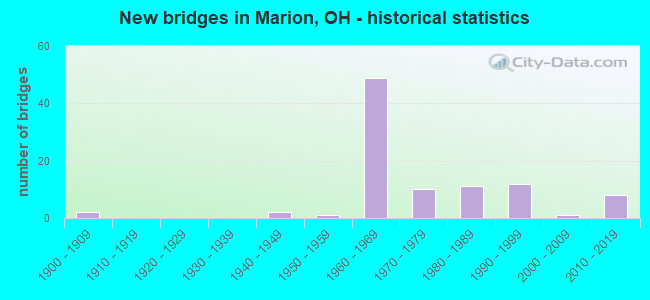
- New bridges - historical statistics
- 21900-1909
- 21940-1949
- 11950-1959
- 491960-1969
- 101970-1979
- 111980-1989
- 121990-1999
- 12000-2009
- 82010-2019
FCC Registered Antenna Towers: 280 (See the full list of FCC Registered Antenna Towers)
FCC Registered Private Land Mobile Towers: 4 (See the full list of FCC Registered Private Land Mobile Towers in Marion, OH)
FCC Registered Broadcast Land Mobile Towers: 74 (See the full list of FCC Registered Broadcast Land Mobile Towers)
FCC Registered Microwave Towers: 78 (See the full list of FCC Registered Microwave Towers in this town)
FCC Registered Paging Towers: 7 (See the full list of FCC Registered Paging Towers)
FCC Registered Maritime Coast & Aviation Ground Towers: 6 (See the full list of FCC Registered Maritime Coast & Aviation Ground Towers)
FCC Registered Amateur Radio Licenses: 260 (See the full list of FCC Registered Amateur Radio Licenses in Marion)
FAA Registered Aircraft: 25 (See the full list of FAA Registered Aircraft in Marion)
2002 - 2018 National Fire Incident Reporting System (NFIRS) incidents
- Fire incident types reported to NFIRS in Marion, OH
- 2,45051.6%Structure Fires
- 1,55632.8%Outside Fires
- 68714.5%Mobile Property/Vehicle Fires
- 551.2%Other
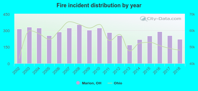 Based on the data from the years 2002 - 2018 the average number of fires per year is 279. The highest number of fires - 352 took place in 2008, and the least - 169 in 2013. The data has a declining trend.
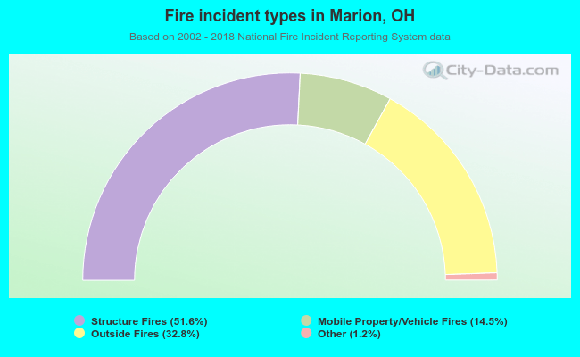 When looking into fire subcategories, the most reports belonged to: Structure Fires (51.6%), and Outside Fires (32.8%).
Fire-safe hotels and motels in Marion, Ohio:
- Fairfield Inn Marion, 227 James Way, Marion, Ohio 43302 , Phone: (740) 389-6636, Fax: (740) 389-6636
- Comfort Inn, 256 Jamesway, Marion, Ohio 43302 , Phone: (740) 389-5552, Fax: (740) 389-5552
- Country Inn & Suites, 2091 Marion Mt Gilead Rd, Marion, Ohio 43302 , Phone: (740) 386-5451, Fax: (740) 386-5451
- Americas Best Value Inn, 1952 Marion Mtgilead Rd, Marion, Ohio 43302 , Phone: (740) 389-4671, Fax: (740) 389-4671
- Holiday Inn Express & Suites, 1842 Marion Mt Gilead Rd, Marion, Ohio 43302 , Phone: (740) 389-4300, Fax: (740) 389-4300
| Most common first names in Marion, OH among deceased individuals | ||
| Name | Count | Lived (average) |
|---|---|---|
| Mary | 521 | 78.4 years |
| John | 386 | 73.5 years |
| William | 376 | 73.2 years |
| Robert | 366 | 70.9 years |
| James | 307 | 71.9 years |
| Charles | 272 | 73.4 years |
| Ruth | 220 | 79.4 years |
| Helen | 194 | 79.6 years |
| George | 186 | 76.1 years |
| Donald | 176 | 70.4 years |
| Most common last names in Marion, OH among deceased individuals | ||
| Last name | Count | Lived (average) |
|---|---|---|
| Smith | 243 | 74.7 years |
| Miller | 118 | 76.2 years |
| Brown | 109 | 76.0 years |
| Davis | 104 | 74.2 years |
| Williams | 99 | 74.9 years |
| Jones | 90 | 74.4 years |
| Johnson | 67 | 74.7 years |
| Wilson | 65 | 74.7 years |
| Martin | 63 | 74.1 years |
| Moore | 62 | 77.6 years |
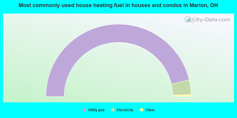
- 92.6%Utility gas
- 6.6%Electricity
- 0.3%Other fuel
- 0.2%Wood
- 0.2%Bottled, tank, or LP gas
- 0.1%Fuel oil, kerosene, etc.
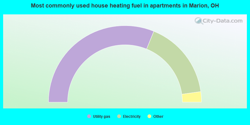
- 62.3%Utility gas
- 33.3%Electricity
- 3.0%Bottled, tank, or LP gas
- 0.7%Other fuel
- 0.6%No fuel used
Marion compared to Ohio state average:
- Median house value below state average.
- Unemployed percentage below state average.
- Foreign-born population percentage significantly below state average.
- House age above state average.
- Institutionalized population percentage significantly above state average.
- Percentage of population with a bachelor's degree or higher below state average.
Marion on our top lists:
- #82 on the list of "Top 101 cities with the highest number of burglaries per 100,000 residents, excludes tourist destinations and others with a lot of outsiders visiting based on city industries data (population 5,000+)"
- #98 on the list of "Top 101 counties with the largest number of people moving out compared to moving in (pop. 50,000+)"

|
|
Total of 45 patent applications in 2008-2024.