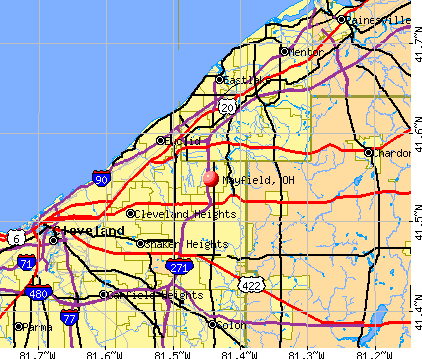
Mayfield, Ohio
Submit your own pictures of this village and show them to the world
- OSM Map
- General Map
- Google Map
- MSN Map
Population change since 2000: -4.0%
 |
| Males: 1,562 | |
| Females: 1,736 |
| Median resident age: | 48.8 years |
| Ohio median age: | 39.9 years |
Zip codes: 44143.
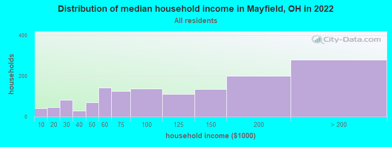
| Mayfield: | $106,096 |
| OH: | $65,720 |
Estimated per capita income in 2022: $55,511 (it was $36,360 in 2000)
Mayfield village income, earnings, and wages data
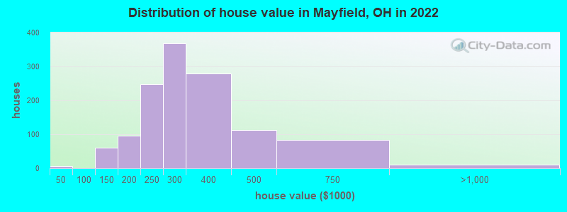
Estimated median house or condo value in 2022: $303,853 (it was $200,300 in 2000)
| Mayfield: | $303,853 |
| OH: | $204,100 |
Mean prices in 2022: all housing units: $235,815; detached houses: $243,339; townhouses or other attached units: $214,792; in 2-unit structures: $118,975; in 3-to-4-unit structures: $232,984; in 5-or-more-unit structures: $177,601; mobile homes: $87,444
Median gross rent in 2022: $1,516.
(2.8% for White Non-Hispanic residents, 47.5% for Black residents)
Detailed information about poverty and poor residents in Mayfield, OH
Compare current foreclosures near Mayfield, OH:
| Photo | Address | Area | Beds / Baths | Price | Details |
|---|---|---|---|---|---|

|
#1
E 137th St
Cleveland, OH 44120
|
1,637 sq. feet
|
1 baths 3 beds |
$59,900
|
show details |

|
#2
Creekwood Ln
Cleveland, OH 44143
|
4,154 sq. feet
|
3 baths 5 beds |
$425,900
|
show details |

|
#3
Wilmington Rd
Cleveland, OH 44121
|
1,278 sq. feet
|
1 baths 3 beds |
$134,900
|
show details |

|
#4
E 128th St
Cleveland, OH 44120
|
1,894 sq. feet
|
1 baths 4 beds |
$44,900
|
show details |

|
#5
Lee Rd
Cleveland, OH 44128
|
912 sq. feet
|
1 baths 3 beds |
$44,100
|
show details |

|
#6
Miller Ave
Cleveland, OH 44119
|
830 sq. feet
|
1 baths 2 beds |
$149,900
|
show details |

|
#7
E 262nd St
Euclid, OH 44132
|
1,245 sq. feet
|
3 baths 4 beds |
$209,900
|
show details |

|
#8
Alton Rd
Wickliffe, OH 44092
|
936 sq. feet
|
1 baths 3 beds |
$159,900
|
show details |

|
#9
Wellner Rd
Eastlake, OH 44095
|
1,030 sq. feet
|
2 baths 3 beds |
$194,900
|
show details |

|
#10
Oak St
Willoughby, OH 44094
|
958 sq. feet
|
1 baths 3 beds |
$115,000
|
show details |
| Photo | Address | Area | Beds / Baths | Price | Details |
|---|---|---|---|---|---|

|
#11
Hastings Rd
Cleveland, OH 44125
|
1,578 sq. feet
|
1 baths 4 beds |
$164,900
|
show details |

|
#12
Maryland Ave
Cleveland, OH 44105
|
1,908 sq. feet
|
2 baths 4 beds |
$29,900
|
show details |

|
#13
65 Noble Rd
Cleveland, OH 44112
|
- sq. feet
|
2 baths 4 beds |
$29,900
|
show details |

|
#14
Daleford Rd
Cleveland, OH 44120
|
3,164 sq. feet
|
3 baths 6 beds |
show details | |

|
#15
Worley Ave
Cleveland, OH 44105
|
1,956 sq. feet
|
2 baths 6 beds |
show details | |

|
#16
Van Aken Blvd Apt 207
Beachwood, OH 44122
|
798 sq. feet
|
1 baths 2 beds |
show details | |

|
#17
Cleveland Rd
Cleveland, OH 44108
|
2,088 sq. feet
|
2 baths 4 beds |
show details | |

|
#18
Shaw Ave
Cleveland, OH 44112
|
1,696 sq. feet
|
2 baths 4 beds |
show details | |

|
#19
Stevenson Rd
Cleveland, OH 44110
|
2,502 sq. feet
|
2 baths 7 beds |
show details | |

|
#20
Bucyrus Ave
Cleveland, OH 44109
|
2,064 sq. feet
|
2 baths 4 beds |
show details |
| Photo | Address | Area | Beds / Baths | Price | Details |
|---|---|---|---|---|---|

|
#21
S Green Rd
Cleveland, OH 44121
|
1,096 sq. feet
|
1 baths 3 beds |
show details | |

|
#22
Matilda Ave
Cleveland, OH 44105
|
1,324 sq. feet
|
1 baths 3 beds |
show details | |

|
#23
Genesee Rd
Euclid, OH 44117
|
- sq. feet
|
2 baths 4 beds |
show details | |

|
#24
Maryland Ave
Cleveland, OH 44105
|
1,056 sq. feet
|
1 baths 3 beds |
show details | |

|
#25
Faversham Rd
Cleveland, OH 44118
|
2,118 sq. feet
|
1 baths 3 beds |
show details | |

|
#26
Akron St
Chagrin Falls, OH 44023
|
1,228 sq. feet
|
1 baths 3 beds |
show details | |

|
#27
Palmetto Ave
Bedford, OH 44146
|
1,068 sq. feet
|
1 baths 3 beds |
show details | |

|
#28
Kinsman Rd
Cleveland, OH 44120
|
1,724 sq. feet
|
1 baths 4 beds |
show details | |

|
#29
E 347th St
Eastlake, OH 44095
|
1,352 sq. feet
|
1 baths 4 beds |
show details | |

|
#30
Somerton Rd
Cleveland, OH 44118
|
1,260 sq. feet
|
2 baths 6 beds |
show details |
| Photo | Address | Area | Beds / Baths | Price | Details |
|---|---|---|---|---|---|

|
#31
Noble Beach Dr
Euclid, OH 44123
|
1,991 sq. feet
|
2 baths 4 beds |
show details | |

|
#32
E 189th St
Beachwood, OH 44122
|
988 sq. feet
|
1 baths 3 beds |
show details | |

|
#33
Gifford Ave
Cleveland, OH 44109
|
1,619 sq. feet
|
2 baths 4 beds |
show details | |

|
#34
Greyton Rd
Cleveland, OH 44112
|
1,670 sq. feet
|
1 baths 3 beds |
show details | |

|
#35
E 341st St
Eastlake, OH 44095
|
1,204 sq. feet
|
1 baths 3 beds |
show details | |

|
#36
Helmsdale Rd
Cleveland, OH 44112
|
1,316 sq. feet
|
1 baths 3 beds |
show details | |

|
#37
E 114th St
Cleveland, OH 44125
|
1,728 sq. feet
|
1 baths 3 beds |
show details | |

|
#38
Kennerdown Ave
Maple Heights, OH 44137
|
1,188 sq. feet
|
1 baths 3 beds |
show details | |

|
#39
King St
Painesville, OH 44077
|
722 sq. feet
|
1 baths 2 beds |
show details | |

|
#40
Greenvale Rd
Cleveland, OH 44121
|
1,117 sq. feet
|
1 baths 3 beds |
show details |
| Photo | Address | Area | Beds / Baths | Price | Details |
|---|---|---|---|---|---|

|
#41
Berkshire Rd
Cleveland, OH 44118
|
1,690 sq. feet
|
2 baths 4 beds |
show details | |

|
#42
E 153rd St
Cleveland, OH 44128
|
783 sq. feet
|
1 baths 2 beds |
show details | |

|
#43
Hayden Ave
Cleveland, OH 44112
|
2,696 sq. feet
|
2 baths 4 beds |
show details | |

|
#44
Judson Dr
Cleveland, OH 44128
|
1,344 sq. feet
|
1 baths 2 beds |
show details | |

|
#45
Chatworth Dr
Euclid, OH 44117
|
1,433 sq. feet
|
2 baths 3 beds |
show details | |

|
#46
E Cobblestone Ln
Twinsburg, OH 44087
|
1,814 sq. feet
|
2 baths 3 beds |
show details | |

|
#47
Ellison Rd
Cleveland, OH 44121
|
1,498 sq. feet
|
1 baths 3 beds |
show details | |

|
#48
-07 E Derbyshire Rd
Cleveland, OH 44118
|
3,918 sq. feet
|
2 baths 7 beds |
show details | |

|
#49
Henderson Rd
Cleveland, OH 44112
|
1,327 sq. feet
|
1 baths 3 beds |
show details | |

|
Check over 1 million property listings on Foreclosure.com!
|
browse all offers | |||


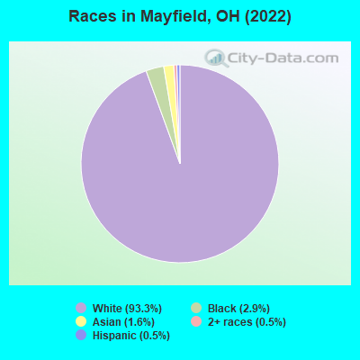
- 3,06993.3%White alone
- 972.9%Black alone
- 521.6%Asian alone
- 160.5%Two or more races
- 160.5%Hispanic
Races in Mayfield detailed stats: ancestries, foreign born residents, place of birth
Type |
2009 |
2010 |
2011 |
2012 |
2013 |
2014 |
|---|---|---|---|---|---|---|
| Murders (per 100,000) | 0 (0.0) | 0 (0.0) | 0 (0.0) | 0 (0.0) | 0 (0.0) | 0 (0.0) |
| Rapes (per 100,000) | 0 (0.0) | 0 (0.0) | 0 (0.0) | 0 (0.0) | 0 (0.0) | 0 (0.0) |
| Robberies (per 100,000) | 1 (32.4) | 0 (0.0) | 0 (0.0) | 0 (0.0) | 0 (0.0) | 0 (0.0) |
| Assaults (per 100,000) | 3 (97.1) | 0 (0.0) | 0 (0.0) | 2 (58.2) | 5 (146.6) | 0 (0.0) |
| Burglaries (per 100,000) | 11 (356.1) | 8 (231.2) | 5 (144.4) | 10 (291.2) | 4 (117.3) | 0 (0.0) |
| Thefts (per 100,000) | 50 (1,619) | 37 (1,069) | 9 (259.9) | 56 (1,631) | 33 (967.7) | 1 (29.3) |
| Auto thefts (per 100,000) | 1 (32.4) | 0 (0.0) | 0 (0.0) | 0 (0.0) | 2 (58.7) | 0 (0.0) |
| Arson (per 100,000) | 0 (0.0) | 0 (0.0) | 0 (0.0) | 0 (0.0) | 0 (0.0) | 0 (0.0) |
| City-Data.com crime index | 121.4 | 59.0 | 20.5 | 97.3 | 80.9 | 1.2 |
The City-Data.com crime index weighs serious crimes and violent crimes more heavily. Higher means more crime, U.S. average is 246.1. It adjusts for the number of visitors and daily workers commuting into cities.
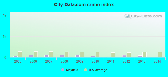
Crime rate in Mayfield detailed stats: murders, rapes, robberies, assaults, burglaries, thefts, arson
Full-time law enforcement employees in 2010, including police officers: 24 (16 officers - 15 male; 1 female).
| Officers per 1,000 residents here: | 4.62 |
| Ohio average: | 2.11 |
 Recent articles from our blog. Our writers, many of them Ph.D. graduates or candidates, create easy-to-read articles on a wide variety of topics.

 | Baker Mayfield struggles may doom season (149 replies) |
| Charming “Main Street” Places in or near Cleveland (133 replies) |
| artsy areas in Cleveland? (37 replies) |
| Official Cleveland relocation thread (517 replies) |
| Relocating to Cleveland - School - Neighborhood Suggestions (70 replies) |
| Mayfield and Mayfield Heights (0 replies) |
Latest news from Mayfield, OH collected exclusively by city-data.com from local newspapers, TV, and radio stations
Ancestries: Italian (30.4%), Arab (9.7%), Irish (7.5%), German (7.0%), Polish (6.5%), Russian (5.4%).
Current Local Time: EST time zone
Incorporated in 1974
Elevation: 927 feet
Land area: 3.92 square miles.
Population density: 840 people per square mile (low).
384 residents are foreign born (5.8% Asia, 5.4% Europe).
| This village: | 11.7% |
| Ohio: | 4.9% |
Median real estate property taxes paid for housing units with mortgages in 2022: $5,348 (1.8%)
Median real estate property taxes paid for housing units with no mortgage in 2022: $6,718 (2.2%)
Nearest city with pop. 50,000+: Euclid, OH  (5.1 miles , pop. 52,717).
Nearest city with pop. 200,000+: Cleveland, OH (12.6 miles , pop. 478,403).
Nearest city with pop. 1,000,000+: Chicago, IL (322.6 miles , pop. 2,896,016).
Nearest cities:
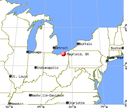
), ), ), )Latitude: 41.55 N, Longitude: 81.44 W
Daytime population change due to commuting: +5,692 (+173.0%)
Workers who live and work in this village: 450 (24.8%)
Area code commonly used in this area: 440
Property values in Mayfield, OH
Mayfield, Ohio accommodation & food services, waste management - Economy and Business Data
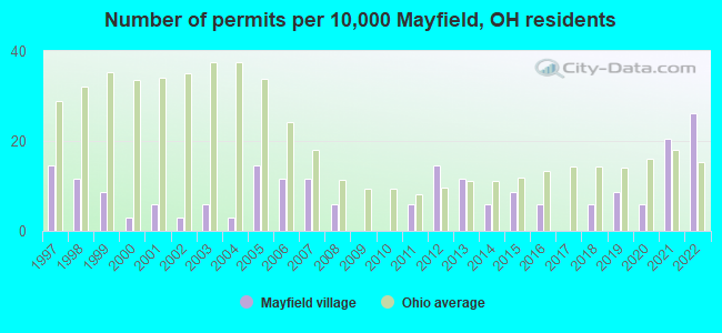
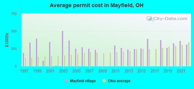
Single-family new house construction building permits:
- 2022: 9 buildings, average cost: $312,200
- 2021: 7 buildings, average cost: $366,400
- 2020: 2 buildings, average cost: $330,000
- 2019: 3 buildings, average cost: $265,700
- 2018: 2 buildings, average cost: $377,500
- 2016: 2 buildings, average cost: $395,000
- 2015: 3 buildings, average cost: $260,000
- 2014: 2 buildings, average cost: $250,000
- 2013: 4 buildings, average cost: $242,500
- 2012: 5 buildings, average cost: $265,000
- 2011: 2 buildings, average cost: $300,000
- 2008: 2 buildings, average cost: $237,500
- 2007: 4 buildings, average cost: $254,000
- 2006: 4 buildings, average cost: $274,800
- 2005: 5 buildings, average cost: $254,400
- 2004: 1 building, cost: $375,000
- 2003: 2 buildings, average cost: $510,000
- 2002: 1 building, cost: $15,000
- 2001: 2 buildings, average cost: $350,000
- 2000: 1 building, cost: $85,000
- 1999: 3 buildings, average cost: $400,000
- 1998: 4 buildings, average cost: $344,300
- 1997: 5 buildings, average cost: $192,600
| Here: | 3.2% |
| Ohio: | 3.1% |
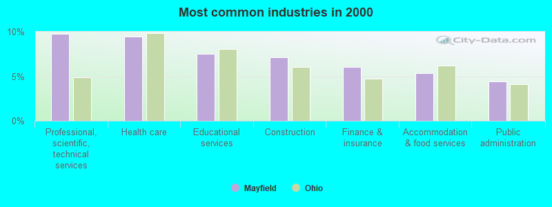
- Professional, scientific, technical services (9.8%)
- Health care (9.4%)
- Educational services (7.5%)
- Construction (7.1%)
- Finance & insurance (6.1%)
- Accommodation & food services (5.4%)
- Public administration (4.4%)
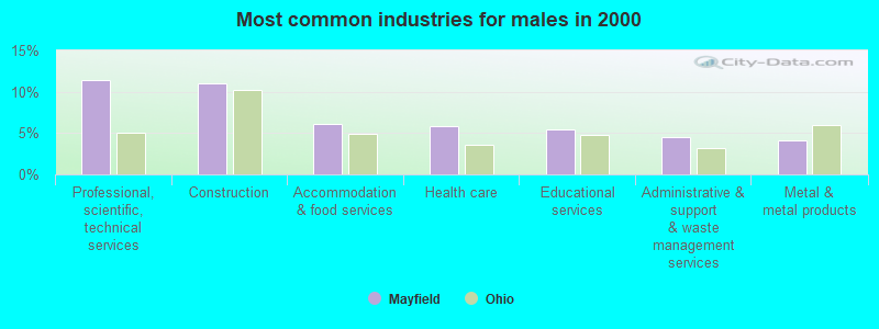
- Professional, scientific, technical services (11.4%)
- Construction (11.0%)
- Accommodation & food services (6.1%)
- Health care (5.9%)
- Educational services (5.5%)
- Administrative & support & waste management services (4.5%)
- Metal & metal products (4.1%)
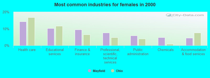
- Health care (14.3%)
- Educational services (10.3%)
- Finance & insurance (9.5%)
- Professional, scientific, technical services (7.6%)
- Public administration (5.9%)
- Chemicals (4.9%)
- Accommodation & food services (4.5%)
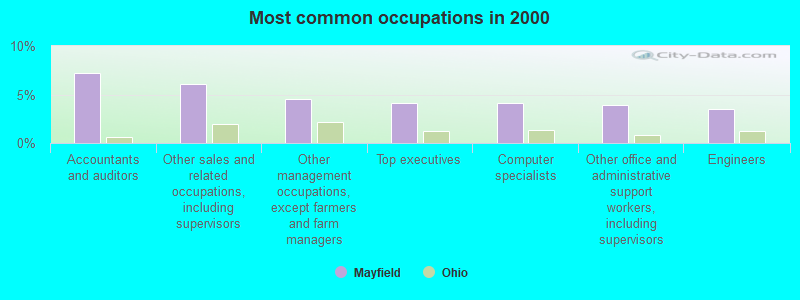
- Accountants and auditors (7.2%)
- Other sales and related occupations, including supervisors (6.1%)
- Other management occupations, except farmers and farm managers (4.5%)
- Top executives (4.1%)
- Computer specialists (4.1%)
- Other office and administrative support workers, including supervisors (3.9%)
- Engineers (3.5%)
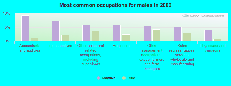
- Accountants and auditors (9.1%)
- Top executives (7.1%)
- Other sales and related occupations, including supervisors (5.8%)
- Engineers (5.8%)
- Other management occupations, except farmers and farm managers (5.6%)
- Sales representatives, services, wholesale and manufacturing (5.2%)
- Physicians and surgeons (4.2%)

- Secretaries and administrative assistants (6.8%)
- Other sales and related occupations, including supervisors (6.5%)
- Other office and administrative support workers, including supervisors (6.2%)
- Retail sales workers, except cashiers (5.5%)
- Bookkeeping, accounting, and auditing clerks (5.3%)
- Computer specialists (5.3%)
- Accountants and auditors (4.6%)
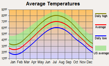
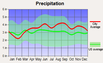
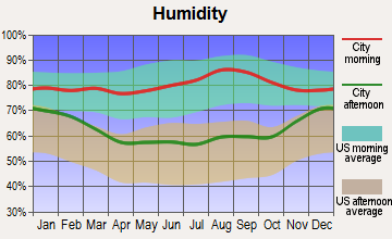
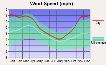
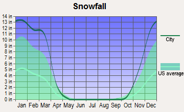
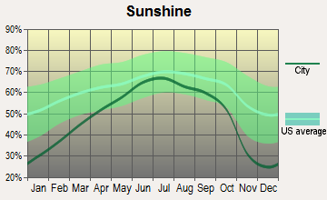
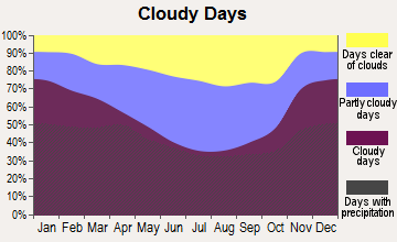
Average climate in Mayfield, Ohio
Based on data reported by over 4,000 weather stations
|
|


(lower is better)
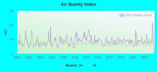
Air Quality Index (AQI) level in 2023 was 108. This is significantly worse than average.
| City: | 108 |
| U.S.: | 73 |
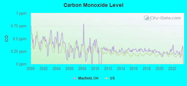
Carbon Monoxide (CO) [ppm] level in 2023 was 0.235. This is about average. Closest monitor was 6.7 miles away from the city center.
| City: | 0.235 |
| U.S.: | 0.251 |
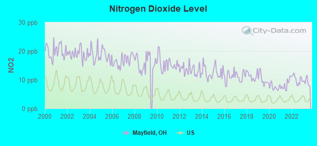
Nitrogen Dioxide (NO2) [ppb] level in 2023 was 9.32. This is significantly worse than average. Closest monitor was 1.1 miles away from the city center.
| City: | 9.32 |
| U.S.: | 5.11 |
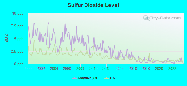
Sulfur Dioxide (SO2) [ppb] level in 2023 was 0.491. This is significantly better than average. Closest monitor was 1.1 miles away from the city center.
| City: | 0.491 |
| U.S.: | 1.515 |
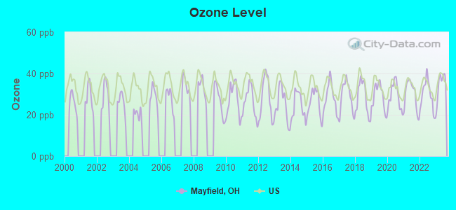
Ozone [ppb] level in 2023 was 34.2. This is about average. Closest monitor was 6.8 miles away from the city center.
| City: | 34.2 |
| U.S.: | 33.3 |
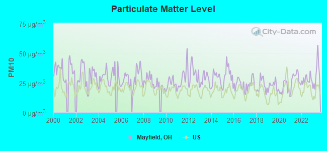
Particulate Matter (PM10) [µg/m3] level in 2023 was 32.2. This is significantly worse than average. Closest monitor was 12.2 miles away from the city center.
| City: | 32.2 |
| U.S.: | 19.2 |
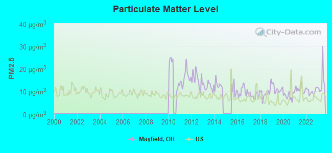
Particulate Matter (PM2.5) [µg/m3] level in 2023 was 13.9. This is significantly worse than average. Closest monitor was 9.2 miles away from the city center.
| City: | 13.9 |
| U.S.: | 8.1 |
Tornado activity:
Mayfield-area historical tornado activity is slightly below Ohio state average. It is 12% smaller than the overall U.S. average.
On 5/31/1985, a category F5 (max. wind speeds 261-318 mph) tornado 28.5 miles away from the Mayfield village center killed 18 people and injured 310 people and caused between $50,000,000 and $500,000,000 in damages.
On 6/8/1953, a category F4 (max. wind speeds 207-260 mph) tornado 14.7 miles away from the village center killed 17 people and injured 379 people.
Earthquake activity:
Mayfield-area historical earthquake activity is significantly above Ohio state average. It is 52% smaller than the overall U.S. average.On 9/25/1998 at 19:52:52, a magnitude 5.2 (4.8 MB, 4.3 MS, 5.2 LG, 4.5 MW, Depth: 3.1 mi, Class: Moderate, Intensity: VI - VII) earthquake occurred 54.4 miles away from the city center
On 1/31/1986 at 16:46:43, a magnitude 5.0 (5.0 MB) earthquake occurred 15.1 miles away from the city center
On 8/23/2011 at 17:51:04, a magnitude 5.8 (5.8 MW, Depth: 3.7 mi) earthquake occurred 313.2 miles away from the city center
On 6/10/2019 at 14:50:45, a magnitude 4.0 (4.0 MB, Depth: 1.2 mi, Class: Light, Intensity: IV - V) earthquake occurred 9.1 miles away from the city center
On 7/27/1980 at 18:52:21, a magnitude 5.2 (5.1 MB, 4.7 MS, 5.0 UK, 5.2 UK) earthquake occurred 266.5 miles away from the city center
On 12/31/2011 at 20:05:01, a magnitude 4.0 (4.0 ML, Depth: 3.1 mi) earthquake occurred 49.2 miles away from the city center
Magnitude types: regional Lg-wave magnitude (LG), body-wave magnitude (MB), local magnitude (ML), surface-wave magnitude (MS), moment magnitude (MW)
Natural disasters:
The number of natural disasters in Cuyahoga County (16) is near the US average (15).Major Disasters (Presidential) Declared: 12
Emergencies Declared: 3
Causes of natural disasters: Storms: 9, Floods: 8, Tornadoes: 7, Winds: 3, Hurricanes: 2, Blizzard: 1, Heavy Rain: 1, Power Outage: 1, Snowstorm: 1, Tropical Storm: 1, Other: 1 (Note: some incidents may be assigned to more than one category).
Hospitals and medical centers near Mayfield:
- PLATINUM HOME HEALTH SERVICES (Home Health Center, about 1 miles away; MAYFIELD VILLAGE, OH)
- PROVIDENCE HOME HEALTH CARE, INC (Home Health Center, about 1 miles away; HIGHLAND HEIGHTS, OH)
- ALTERCARE OF MAYFIELD VILLAGE, INC (Nursing Home, about 2 miles away; MAYFIELD VILLAGE, OH)
- MANORCARE HEALTH SERVICES-MAYFIELD HTS (Nursing Home, about 2 miles away; MAYFIELD HEIGHTS, OH)
- HILLCREST HOSPITAL Acute Care Hospitals (about 2 miles away; MAYFIELD HEIGHTS, OH)
- KINDRED TRANSITIONAL CARE AND REHAB-THE GREENS (Nursing Home, about 3 miles away; LYNDHURST, OH)
- HOMEWOOD RESIDENCE AT RICHMOND HEIGHTS CARE CENTER (Nursing Home, about 3 miles away; RICHMOND HEIGHTS, OH)
Amtrak station near Mayfield:
Colleges/universities with over 2000 students nearest to Mayfield:
- John Carroll University (about 7 miles; University Heights, OH; Full-time enrollment: 3,546)
- Lakeland Community College (about 8 miles; Kirtland, OH; FT enrollment: 6,170)
- Case Western Reserve University (about 10 miles; Cleveland, OH; FT enrollment: 7,034)
- Cleveland State University (about 13 miles; Cleveland, OH; FT enrollment: 14,161)
- Cuyahoga Community College District (about 13 miles; Cleveland, OH; FT enrollment: 20,271)
- Baldwin Wallace University (about 25 miles; Berea, OH; FT enrollment: 3,699)
- Kent State University at Kent (about 29 miles; Kent, OH; FT enrollment: 25,431)
Public elementary/middle school in Mayfield:
- MAYFIELD CENTER ELEMENTARY SCHOOL (Students: 366, Location: 6625 WILSON MILLS RD, Grades: KG-5)
Points of interest:
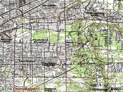
Notable locations in Mayfield: Forest Picnic Area (A), North Chagrin Nature Center (B), Mayfield Village Fire Department (C), Mayfield Town Hall (D). Display/hide their locations on the map
Cemeteries: Whitehaven Memorial Park (1), Mayfield Union Cemetery (2), Mount Sinai Cemetery (3). Display/hide their locations on the map
Park in Mayfield: Roadside Park (1). Display/hide its location on the map
| This village: | 2.3 people |
| Ohio: | 2.4 people |
| This village: | 64.5% |
| Whole state: | 65.0% |
| This village: | 3.1% |
| Whole state: | 6.8% |
Likely homosexual households (counted as self-reported same-sex unmarried-partner households)
- Lesbian couples: 0.2% of all households
- Gay men: 0.1% of all households
For population 15 years and over in Mayfield:
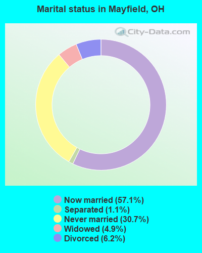
- Never married: 30.7%
- Now married: 57.1%
- Separated: 1.1%
- Widowed: 4.9%
- Divorced: 6.2%
For population 25 years and over in Mayfield:
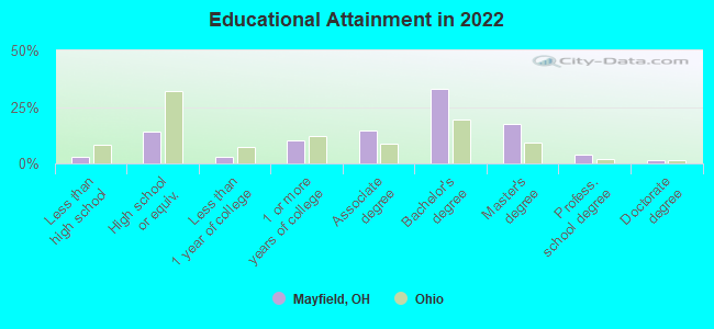
- High school or higher: 97.0%
- Bachelor's degree or higher: 53.1%
- Graduate or professional degree: 21.0%
- Unemployed: 2.3%
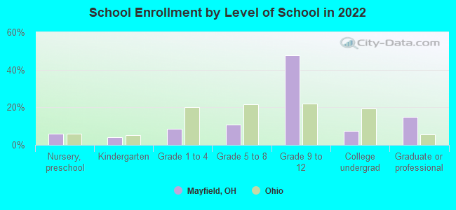
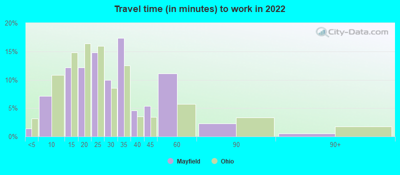
- Mean travel time to work (commute): 19.4 minutes
| Here: | 8.2 |
| Ohio average: | 11.0 |
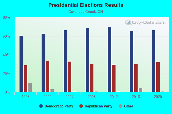
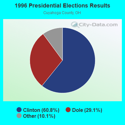
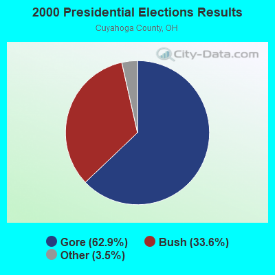
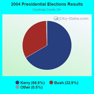
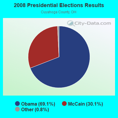
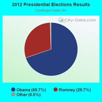
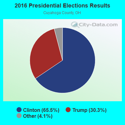
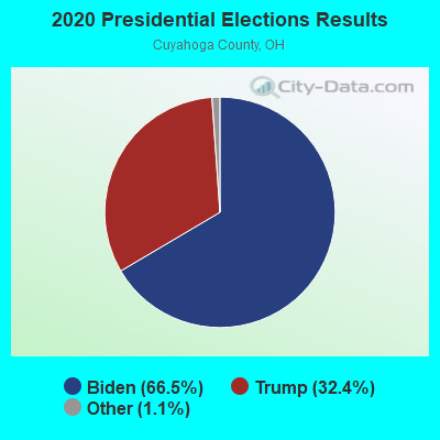
Graphs represent county-level data. Detailed 2008 Election Results
Religion statistics for Mayfield, OH (based on Cuyahoga County data)
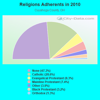
| Religion | Adherents | Congregations |
|---|---|---|
| Catholic | 366,464 | 110 |
| Evangelical Protestant | 106,477 | 326 |
| Mainline Protestant | 94,977 | 233 |
| Other | 49,641 | 126 |
| Black Protestant | 40,776 | 129 |
| Orthodox | 16,456 | 31 |
| None | 605,331 | - |
Food Environment Statistics:
| Cuyahoga County: | 2.33 / 10,000 pop. |
| Ohio: | 1.89 / 10,000 pop. |
| Cuyahoga County: | 0.05 / 10,000 pop. |
| Ohio: | 0.13 / 10,000 pop. |
| Cuyahoga County: | 1.68 / 10,000 pop. |
| State: | 1.25 / 10,000 pop. |
| Cuyahoga County: | 2.26 / 10,000 pop. |
| State: | 2.93 / 10,000 pop. |
| Cuyahoga County: | 6.88 / 10,000 pop. |
| State: | 6.25 / 10,000 pop. |
| Here: | 10.8% |
| Ohio: | 10.3% |
| Cuyahoga County: | 28.3% |
| State: | 29.1% |
| Cuyahoga County: | 10.4% |
| Ohio: | 11.9% |
Health and Nutrition:
| Mayfield: | 51.2% |
| Ohio: | 50.4% |
| This city: | 46.5% |
| Ohio: | 47.8% |
| This city: | 29.3 |
| Ohio: | 28.7 |
| Mayfield: | 21.2% |
| State: | 20.6% |
| Mayfield: | 14.6% |
| Ohio: | 10.4% |
| Mayfield: | 6.8 |
| State: | 6.8 |
| This city: | 36.9% |
| State: | 34.3% |
| Mayfield: | 55.2% |
| Ohio: | 57.0% |
| Mayfield: | 74.6% |
| Ohio: | 79.1% |
More about Health and Nutrition of Mayfield, OH Residents
| Local government employment and payroll (March 2022) | |||||
| Function | Full-time employees | Monthly full-time payroll | Average yearly full-time wage | Part-time employees | Monthly part-time payroll |
|---|---|---|---|---|---|
| Other and Unallocable | 18 | $124,988 | $83,325 | 0 | $0 |
| Police Protection - Officers | 17 | $160,259 | $113,124 | 4 | $17,874 |
| Firefighters | 15 | $131,356 | $105,085 | 6 | $15,655 |
| Police - Other | 13 | $73,556 | $67,898 | 6 | $13,458 |
| Financial Administration | 4 | $31,445 | $94,335 | 0 | $0 |
| Parks and Recreation | 3 | $22,464 | $89,856 | 3 | $356 |
| Fire - Other | 3 | $27,012 | $108,048 | 0 | $0 |
| Other Government Administration | 3 | $24,773 | $99,092 | 9 | $8,802 |
| Streets and Highways | 0 | $0 | 1 | $1,278 | |
| Judicial and Legal | 0 | $0 | 3 | $4,781 | |
| Totals for Government | 76 | $595,853 | $94,082 | 32 | $62,203 |
Mayfield government finances - Expenditure in 2021 (per resident):
- Construction - Regular Highways: $1,376,000 ($417.22)
Parks and Recreation: $945,000 ($286.54)
Local Fire Protection: $40,000 ($12.13)
General - Other: $8,000 ($2.43)
Sewerage: $8,000 ($2.43)
- Current Operations - Police Protection: $4,463,000 ($1353.24)
Local Fire Protection: $3,076,000 ($932.69)
General - Other: $2,966,000 ($899.33)
Parks and Recreation: $1,112,000 ($337.17)
Financial Administration: $1,102,000 ($334.14)
Central Staff Services: $642,000 ($194.66)
Protective Inspection and Regulation - Other: $395,000 ($119.77)
Regular Highways: $249,000 ($75.50)
Solid Waste Management: $222,000 ($67.31)
Judicial and Legal Services: $184,000 ($55.79)
General Public Buildings: $172,000 ($52.15)
Housing and Community Development: $142,000 ($43.06)
Health - Other: $52,000 ($15.77)
Miscellaneous Commercial Activities - Other: $19,000 ($5.76)
- General - Interest on Debt: $153,000 ($46.39)
- Other Capital Outlay - General - Other: $563,000 ($170.71)
Police Protection: $111,000 ($33.66)
Local Fire Protection: $26,000 ($7.88)
Parks and Recreation: $10,000 ($3.03)
- Total Salaries and Wages: $7,898,000 ($2394.78)
Mayfield government finances - Revenue in 2021 (per resident):
- Charges - Other: $294,000 ($89.14)
Parks and Recreation: $148,000 ($44.88)
- Local Intergovernmental - Other: $1,134,000 ($343.84)
General Local Government Support: $35,000 ($10.61)
Highways: $26,000 ($7.88)
Public Welfare: $8,000 ($2.43)
- Miscellaneous - General Revenue - Other: $1,415,000 ($429.05)
Interest Earnings: $301,000 ($91.27)
Special Assessments: $165,000 ($50.03)
Rents: $149,000 ($45.18)
Fines and Forfeits: $71,000 ($21.53)
Sale of Property: $29,000 ($8.79)
Donations From Private Sources: $5,000 ($1.52)
- State Intergovernmental - Other: $378,000 ($114.61)
General Local Government Support: $264,000 ($80.05)
Highways: $195,000 ($59.13)
Public Welfare: $18,000 ($5.46)
- Tax - Individual Income: $20,838,000 ($6318.37)
Property: $737,000 ($223.47)
Corporation Net Income: $650,000 ($197.09)
Other Selective Sales: $98,000 ($29.71)
Occupation and Business License - Other: $72,000 ($21.83)
Public Utilities Sales: $66,000 ($20.01)
Amusements Sales: $41,000 ($12.43)
Alcoholic Beverage License: $1,000 ($0.30)
Mayfield government finances - Debt in 2021 (per resident):
- Long Term Debt - Beginning Outstanding - Unspecified Public Purpose: $3,826,000 ($1160.10)
Outstanding Unspecified Public Purpose: $3,425,000 ($1038.51)
Retired Unspecified Public Purpose: $401,000 ($121.59)
Mayfield government finances - Cash and Securities in 2021 (per resident):
- Other Funds - Cash and Securities: $44,231,000 ($13411.46)
- Sinking Funds - Cash and Securities: $3,770,000 ($1143.12)
4.02% of this county's 2021 resident taxpayers lived in other counties in 2020 ($66,006 average adjusted gross income)
| Here: | 4.02% |
| Ohio average: | 5.68% |
0.02% of residents moved from foreign countries ($135 average AGI)
Cuyahoga County: 0.02% Ohio average: 0.01%
Top counties from which taxpayers relocated into this county between 2020 and 2021:
| from Lorain County, OH | |
| from Summit County, OH | |
| from Lake County, OH |
5.02% of this county's 2020 resident taxpayers moved to other counties in 2021 ($88,842 average adjusted gross income)
| Here: | 5.02% |
| Ohio average: | 5.79% |
0.01% of residents moved to foreign countries ($120 average AGI)
Cuyahoga County: 0.01% Ohio average: 0.01%
Top counties to which taxpayers relocated from this county between 2020 and 2021:
| to Lorain County, OH | |
| to Summit County, OH | |
| to Lake County, OH |
Businesses in Mayfield, OH
- Caribou Coffee: 1
- Holiday Inn: 1
- Kincaid: 1
Strongest AM radio stations in Mayfield:
- WKNR (850 AM; 50 kW; CLEVELAND, OH; Owner: CARON BROADCASTING, INC.)
- WTAM (1100 AM; 50 kW; CLEVELAND, OH; Owner: JACOR BROADCASTING CORPORATION)
- WHK (1220 AM; 50 kW; CLEVELAND, OH; Owner: CARON BROADCASTING, INC.)
- WWMK (1260 AM; 10 kW; CLEVELAND, OH; Owner: ABC, INC.)
- WRMR (1420 AM; 5 kW; CLEVELAND, OH; Owner: CLEVELAND CLASSICAL RADIO, LLC)
- WJMO (1490 AM; 1 kW; CLEVELAND HEIGHTS, OH; Owner: BLUE CHIP BROADCASTING LICENSES, LTD.)
- WERE (1300 AM; 5 kW; CLEVELAND, OH)
- WELW (1330 AM; 0 kW; WILLOUGHBY, OH)
- WCUE (1150 AM; 5 kW; CUYAHOGA FALLS, OH; Owner: FAMILY STATIONS, INC.)
- WHLO (640 AM; 5 kW; AKRON, OH; Owner: CLEAR CHANNEL BROADCASTING LICENSES, INC.)
- WABQ (1540 AM; daytime; 1 kW; CLEVELAND, OH; Owner: WABQ, INC.)
- WJR (760 AM; 50 kW; DETROIT, MI; Owner: ABC, INC.)
- WTOU (1350 AM; 5 kW; AKRON, OH)
Strongest FM radio stations in Mayfield:
- WENZ (107.9 FM; CLEVELAND, OH; Owner: RADIO ONE LICENSES, LLC)
- WFHM-FM (95.5 FM; CLEVELAND, OH; Owner: SCA LICENSE CORPORATION)
- WXTM (92.3 FM; CLEVELAND HEIGHTS, OH; Owner: INFINITY RADIO OPERATIONS INC.)
- WJCU (88.7 FM; UNIVERSITY HEIGHTS, OH; Owner: JOHN CARROLL UNIVERSITY)
- WMJI (105.7 FM; CLEVELAND, OH; Owner: CITICASTERS LICENSES, L.P.)
- WDOK (102.1 FM; CLEVELAND, OH; Owner: INFINITY RADIO OPERATIONS INC.)
- WQAL (104.1 FM; CLEVELAND, OH; Owner: INFINITY RADIO OPERATIONS INC.)
- WMVX (106.5 FM; CLEVELAND, OH; Owner: JACOR BROADCASTING CORPORATION)
- WRUW-FM (91.1 FM; CLEVELAND, OH; Owner: CASE WESTERN RESERVE UNIVERSITY)
- WNCX (98.5 FM; CLEVELAND, OH; Owner: INFINITY RADIO OF CLEVELAND INC.)
- WKHR (91.5 FM; BAINBRIDGE, OH; Owner: KENSTON LOCAL SCHOOL DISTRICT)
- WMMS (100.7 FM; CLEVELAND, OH; Owner: CITICASTERS LICENSES, L.P.)
- WCRF-FM (103.3 FM; CLEVELAND, OH; Owner: THE MOODY BIBLE INSTITUTE OF CHICAGO)
- WZAK (93.1 FM; CLEVELAND, OH; Owner: RADIO ONE LICENSES, LLC)
- WCPN (90.3 FM; CLEVELAND, OH; Owner: IDEASTREAM)
- WGAR-FM (99.5 FM; CLEVELAND, OH; Owner: CITICASTERS LICENSES, L.P.)
- WAKS (96.5 FM; AKRON, OH; Owner: CAPSTAR TX LIMITED PARTNERSHIP)
- WKSU-FM (89.7 FM; KENT, OH; Owner: KENT STATE UNIVERSITY)
- WQMX (94.9 FM; MEDINA, OH; Owner: RUBBER CITY RADIO GROUP, INC)
- WONE-FM (97.5 FM; AKRON, OH; Owner: RUBBER CITY RADIO GROUP, INC.)
TV broadcast stations around Mayfield:
- WXOX-LP (Channel 65; CLEVELAND, OH; Owner: VENTURE TECHNOLOGIES GROUP, LLC)
- W53AX (Channel 53; CLEVELAND, OH; Owner: WORD OF GOD FELLOWSHIP, INC.)
- WKYC-TV (Channel 3; CLEVELAND, OH; Owner: WKYC-TV, INC.)
- WRAP-CA (Channel 32; CLEVELAND, OH; Owner: COMMERCIAL BROADCASTING CORP.)
- WOIO (Channel 19; SHAKER HEIGHTS, OH; Owner: RAYCOM NATIONAL, INC.)
- WBNX-TV (Channel 55; AKRON, OH; Owner: WINSTON BROADCASTING NETWORK, INC.)
- W51BI (Channel 51; KIRTLAND, OH; Owner: TRINITY BROADCASTING NETWORK)
- W35AX (Channel 35; CLEVELAND, OH; Owner: MEDIA-COM TELEVISION, INC.)
- WQHS-TV (Channel 61; CLEVELAND, OH; Owner: UNIVISION CLEVELAND LLC)
- WEWS-TV (Channel 5; CLEVELAND, OH; Owner: SCRIPPS HOWARD BROADCASTING COMPANY)
- WUAB (Channel 43; LORAIN, OH; Owner: RAYCOM NATIONAL, INC.)
- WJW (Channel 8; CLEVELAND, OH; Owner: WJW LICENSE, INC.)
- WVIZ (Channel 25; CLEVELAND, OH; Owner: IDEASTREAM)
- WVPX (Channel 23; AKRON, OH; Owner: PAXSON AKRON LICENSE, INC.)
- WEAO (Channel 49; AKRON, OH; Owner: NORTHEASTERN EDUCATIONAL TELEVISION OF OHIO, INC.)
- National Bridge Inventory (NBI) Statistics
- 9Number of bridges
- 92ft / 27.6mTotal length
- 272,736Total average daily traffic
- 21,856Total average daily truck traffic
FCC Registered Antenna Towers:
38 (See the full list of FCC Registered Antenna Towers in Mayfield)FCC Registered Private Land Mobile Towers:
1 (See the full list of FCC Registered Private Land Mobile Towers in Mayfield, OH)FCC Registered Broadcast Land Mobile Towers:
7 (See the full list of FCC Registered Broadcast Land Mobile Towers)FCC Registered Microwave Towers:
2- CLEFP05, 610 Som Center Road (Lat: 41.549444 Lon: -81.441389), Type: Pole, Structure height: 53.3 m, Overall height: 56.4 m, Call Sign: WQEQ239, Licensee ID: L01728370,
Assigned Frequencies: 10875.0 MHz, 19620.0 MHz, 10835.0 MHz, 10715.0 MHz, Grant Date: 03/22/2006, Expiration Date: 03/22/2016, Cancellation Date: 09/11/2013, Certifier: Joseph M Sandri Jr., Registrant: Fibertower Network Services, Corp., Debtor-In-Possession, 1875 Eye Street, Nw, 5th Floor, Room 505, Washington, DC 20006, Phone: (202) 223-1028, Email:
- MAYFIELD VLG, 776 Som Center Rd (Lat: 41.540250 Lon: -81.439694), Type: Mtower, Structure height: 56.1 m, Overall height: 60.6 m, Call Sign: WQLX518,
Assigned Frequencies: 6256.54 MHz, 6256.54 MHz, 6256.54 MHz, 6256.54 MHz, 6256.54 MHz, 6256.54 MHz, 6256.54 MHz, 6256.54 MHz, 6197.24 MHz, Grant Date: 04/02/2020, Expiration Date: 05/18/2030, Certifier: David A Loomis, Registrant: Lake County Telecommunications, 158 East Jackson Street, Painesville, OH 44077, Phone: (440) 350-5555, Fax: (440) 350-2599, Email:
FCC Registered Paging Towers:
2- 5941 Mayfield Rd (Lat: 41.508083 Lon: -81.479833), Overall height: 50.3 m, Call Sign: KNKM900,
Assigned Frequencies: 931.887 MHz, Grant Date: 05/11/1999, Expiration Date: 04/01/2009, Cancellation Date: 01/13/2005, Certifier: Paul H Kuzia, Registrant: Venable, LLP, 575 7th Street, Nw, Washington, DC 20004, Phone: (202) 344-4000, Fax: (202) 344-8300, Email:
- 300 N. Commons Blvd (Lat: 41.564167 Lon: -81.443889), Type: Bant, Structure height: 21.9 m, Overall height: 23.5 m, Call Sign: KWU474,
Assigned Frequencies: 454.025 MHz, Grant Date: 05/11/1999, Expiration Date: 04/01/2009, Cancellation Date: 05/12/2004, Certifier: Paul H Kuzia, Registrant: Wilkinson Barker Knauer, LLP, 2300 N Street, N.W., 7th Floor, Washington, DC 20037, Phone: (202) 783-4141, Fax: (202) 783-5851, Email:
FCC Registered Amateur Radio Licenses:
2- Call Sign: N8XCD, Licensee ID: L00607509, Grant Date: 12/13/2002, Expiration Date: 02/16/2013, Cancellation Date: 02/18/2015, Registrant: Roy A Landon Jr, 5944 Marnell Ave, Mayfield, OH 44124-3066
- Call Sign: KE8BMF, Licensee ID: L01950349, Grant Date: 06/11/2015, Expiration Date: 06/11/2025, Certifier: Mark J Hansen, Registrant: Mark J Hansen, 6596 Kingswood Dr, Mayfield, OH 44124
FAA Registered Aircraft:
3- Aircraft: TEXTRON AVIATION INC 680A (Category: Land, Engines: 2, Seats: 10, Weight: 20,000+ Pounds), Engine: P&W CANADA PW306D (5907 Pounds of Thrust) (Turbo-fan)
N-Number: 751PE, N751PE, N-751PE, Serial Number: 680A0039, Year manufactured: 2016, Airworthiness Date: 06/29/2016, Certificate Issue Date: 07/05/2016
Registrant (LLC): Preformed Line LLC, 660 Beta Dr, Mayfield Village, OH 44143 - Aircraft: TEXTRON AVIATION INC 680A (Category: Land, Engines: 2, Seats: 10, Weight: 20,000+ Pounds), Engine: P&W CANADA PW306D (5907 Pounds of Thrust) (Turbo-fan)
N-Number: 751PL, N751PL, N-751PL, Serial Number: 680A0039, Year manufactured: 2016, Airworthiness Date: 06/29/2016, Certificate Issue Date: 07/05/2016
Registrant (LLC): Preformed Line LLC, 660 Beta Dr, Mayfield Village, OH 44143 - Aircraft: PDPS PZL-BIELSKO SZD-48-3 (Category: Land, Weight: Up to 12,499 Pounds), Engine: None
N-Number: 483EA, N483EA, N-483EA, Serial Number: B-2071, Airworthiness Date: 06/09/1993, Certificate Issue Date: 08/13/1993
Registrant (Individual): Edgardo R Aro, 817 Beech Hill Road, Mayfield Village, OH 44143
Deregistered: Cancel Date: 02/20/2018
| Home Mortgage Disclosure Act Aggregated Statistics For Year 2009 (Based on 1 full tract) | ||||||||
| A) FHA, FSA/RHS & VA Home Purchase Loans | B) Conventional Home Purchase Loans | C) Refinancings | D) Home Improvement Loans | |||||
|---|---|---|---|---|---|---|---|---|
| Number | Average Value | Number | Average Value | Number | Average Value | Number | Average Value | |
| LOANS ORIGINATED | 10 | $166,900 | 26 | $219,000 | 79 | $185,392 | 2 | $42,000 |
| APPLICATIONS APPROVED, NOT ACCEPTED | 0 | $0 | 2 | $167,000 | 10 | $216,000 | 0 | $0 |
| APPLICATIONS DENIED | 6 | $151,833 | 1 | $132,000 | 20 | $232,500 | 2 | $8,000 |
| APPLICATIONS WITHDRAWN | 1 | $200,000 | 2 | $400,000 | 11 | $262,182 | 0 | $0 |
| FILES CLOSED FOR INCOMPLETENESS | 0 | $0 | 0 | $0 | 4 | $272,000 | 0 | $0 |
Detailed HMDA statistics for the following Tracts: 1943.00
| Private Mortgage Insurance Companies Aggregated Statistics For Year 2008 (Based on 1 full tract) | ||||
| A) Conventional Home Purchase Loans | B) Refinancings | |||
|---|---|---|---|---|
| Number | Average Value | Number | Average Value | |
| LOANS ORIGINATED | 4 | $201,250 | 1 | $230,000 |
| APPLICATIONS APPROVED, NOT ACCEPTED | 1 | $247,000 | 0 | $0 |
| APPLICATIONS DENIED | 0 | $0 | 0 | $0 |
| APPLICATIONS WITHDRAWN | 0 | $0 | 0 | $0 |
| FILES CLOSED FOR INCOMPLETENESS | 1 | $143,000 | 0 | $0 |
Detailed PMIC statistics for the following Tracts: 1943.00
- 95.8%Utility gas
- 2.6%Electricity
- 1.0%Bottled, tank, or LP gas
- 0.5%Fuel oil, kerosene, etc.
- 65.2%Utility gas
- 34.8%Electricity
Mayfield compared to Ohio state average:
- Median household income above state average.
- Unemployed percentage significantly below state average.
- Black race population percentage significantly below state average.
- Hispanic race population percentage significantly below state average.
- Median age above state average.
- Foreign-born population percentage significantly above state average.
- Length of stay since moving in significantly above state average.
- Number of rooms per house above state average.
- Percentage of population with a bachelor's degree or higher significantly above state average.
Mayfield on our top lists:
- #11 on the list of "Top 101 cities with the most residents born in Russia (population 500+)"
- #19 on the list of "Top 101 cities with the most residents born in Lebanon (population 500+)"
- #66 on the list of "Top 101 cities with the most residents born in Iran (population 500+)"
- #71 on the list of "Top 101 cities with the most residents born in Italy (population 500+)"
- #85 on the list of "Top 101 cities with the most residents born in Syria (population 500+)"
- #86 on the list of "Top 101 cities with the most residents born in Other Eastern Europe (population 500+)"
- #92 on the list of "Top 101 cities with the most residents born in Eastern Europe (population 500+)"
- #5 on the list of "Top 101 counties with the most Orthodox congregations"
- #9 on the list of "Top 101 counties with the most Catholic congregations"
- #9 on the list of "Top 101 counties with the most Orthodox adherents"
- #10 on the list of "Top 101 counties with the most Black Protestant congregations"
- #11 on the list of "Top 101 counties with the most Mainline Protestant congregations (pop. 50,000+)"

|
|
Total of 13 patent applications in 2008-2024.