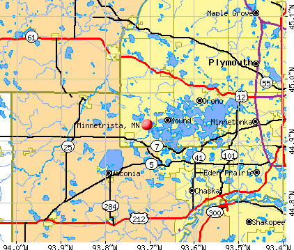
Minnetrista, Minnesota
Submit your own pictures of this city and show them to the world
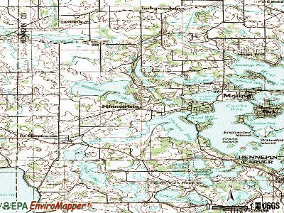
- OSM Map
- General Map
- Google Map
- MSN Map
Population change since 2000: +98.9%
| Males: 4,243 | |
| Females: 4,423 |
| Median resident age: | 43.1 years |
| Minnesota median age: | 39.0 years |
Zip codes: 55364, 55375, 55387, 55388.
Minnetrista Zip Code Map| Minnetrista: | $156,866 |
| MN: | $82,338 |
Estimated per capita income in 2022: $70,196 (it was $40,217 in 2000)
Minnetrista city income, earnings, and wages data
Estimated median house or condo value in 2022: $612,840 (it was $278,900 in 2000)
| Minnetrista: | $612,840 |
| MN: | $314,600 |
Mean prices in 2022: all housing units: $717,267; detached houses: $723,210; townhouses or other attached units: $319,529
Median gross rent in 2022: $2,305.
(7.8% for White Non-Hispanic residents, 9.2% for two or more races residents)
Detailed information about poverty and poor residents in Minnetrista, MN

Compare current foreclosures near Minnetrista, MN:
| Photo | Address | Area | Beds / Baths | Price | Details |
|---|---|---|---|---|---|

|
#1
Fairlawn Ave E
Winsted, MN 55395
|
2,888 sq. feet
|
3 baths 5 beds |
$404,900
|
show details |

|
#2
3rd Ave W
Shakopee, MN 55379
|
1,451 sq. feet
|
1 baths 5 beds |
show details | |

|
#3
Benwood Cir
Chanhassen, MN 55317
|
3,164 sq. feet
|
3 baths 4 beds |
show details | |

|
#4
Livingston Ave
Wayzata, MN 55391
|
1,734 sq. feet
|
1 baths 4 beds |
show details | |

|
#5
Sibley St S
Shakopee, MN 55379
|
1,166 sq. feet
|
1 baths 4 beds |
show details | |

|
#6
Manuela Dr
Chaska, MN 55318
|
2,313 sq. feet
|
2 baths 4 beds |
show details | |

|
#7
43rd Avenue N
Minneapolis, MN 55442
|
1,211 sq. feet
|
2 baths 2 beds |
show details | |

|
#8
Saint Johns Dr
Eden Prairie, MN 55346
|
1,688 sq. feet
|
1 baths 3 beds |
show details | |

|
#9
Norwood Ln N
Osseo, MN 55369
|
1,705 sq. feet
|
3 baths 3 beds |
show details | |

|
#10
18th Ave N
Hopkins, MN 55343
|
900 sq. feet
|
1 baths 3 beds |
show details |
| Photo | Address | Area | Beds / Baths | Price | Details |
|---|---|---|---|---|---|

|
#11
Carmody Dr
Eden Prairie, MN 55344
|
1,230 sq. feet
|
1 baths 2 beds |
show details | |

|
#12
Summit Ave
Loretto, MN 55357
|
2,148 sq. feet
|
2 baths 5 beds |
show details | |

|
#13
Arrowood Ln N
Minneapolis, MN 55442
|
938 sq. feet
|
2 baths 4 beds |
show details | |

|
#14
Breckenridge Ln
Montrose, MN 55363
|
1,328 sq. feet
|
2 baths 3 beds |
show details | |

|
#15
Savanna Valley Way
Victoria, MN 55386
|
2,184 sq. feet
|
3 baths 4 beds |
show details | |

|
#16
Allegheny Grove Blvd
Victoria, MN 55386
|
2,672 sq. feet
|
2 baths 4 beds |
show details | |

|
#17
Sommerville St S
Shakopee, MN 55379
|
1,123 sq. feet
|
1 baths 3 beds |
show details | |

|
#18
Spencer St S
Shakopee, MN 55379
|
1,474 sq. feet
|
1 baths 4 beds |
show details | |

|
#19
Molina St
Shakopee, MN 55379
|
2,822 sq. feet
|
3 baths 4 beds |
show details | |

|
#20
Brush St
Norwood, MN 55368
|
2,078 sq. feet
|
1 baths 3 beds |
show details |
| Photo | Address | Area | Beds / Baths | Price | Details |
|---|---|---|---|---|---|

|
#21
Sunset Ave
Montrose, MN 55363
|
- sq. feet
|
3 baths 3 beds |
show details | |

|
#22
Highpoint Curv
Shakopee, MN 55379
|
1,344 sq. feet
|
1 baths 2 beds |
show details | |

|
#23
Mill Ave
Watertown, MN 55388
|
1,954 sq. feet
|
2 baths 3 beds |
show details | |

|
#24
Naples Ave
Cologne, MN 55322
|
2,374 sq. feet
|
4 baths 4 beds |
show details | |

|
#25
Main St W
Carver, MN 55315
|
1,472 sq. feet
|
2 baths 3 beds |
show details | |

|
#26
Bittersweet Dr
Eden Prairie, MN 55344
|
1,224 sq. feet
|
2 baths 3 beds |
show details | |

|
#27
81st Ave N
Osseo, MN 55311
|
3,738 sq. feet
|
5 baths 6 beds |
show details | |

|
#28
Westminster Ave NW
Watertown, MN 55388
|
2,124 sq. feet
|
2 baths 4 beds |
show details | |

|
#29
W 34 1/2 St
Minneapolis, MN 55426
|
1,387 sq. feet
|
1 baths 3 beds |
show details | |

|
#30
Devon Ln
Mound, MN 55364
|
1,006 sq. feet
|
1 baths 2 beds |
show details |
| Photo | Address | Area | Beds / Baths | Price | Details |
|---|---|---|---|---|---|

|
#31
Appleblossom Ln
Shakopee, MN 55379
|
969 sq. feet
|
2 baths 3 beds |
show details | |

|
#32
Bay Ridge Rd
Mound, MN 55364
|
3,200 sq. feet
|
3 baths 3 beds |
show details | |

|
#33
Dominick Dr
Hopkins, MN 55343
|
2,240 sq. feet
|
3 baths 4 beds |
show details | |
|
|
#34
Shady Oak Rd S
Hopkins, MN 55343
|
2,390 sq. feet
|
3 baths 3 beds |
show details | |

|
#35
Topview Rd
Eden Prairie, MN 55346
|
1,739 sq. feet
|
3 baths 5 beds |
show details | |

|
#36
Cardinal Cove Dr
Mound, MN 55364
|
2,281 sq. feet
|
2 baths 3 beds |
show details | |

|
#37
Minnesota St S
Shakopee, MN 55379
|
1,138 sq. feet
|
2 baths 4 beds |
show details | |

|
#38
Sherwood Hills Rd
Hopkins, MN 55305
|
3,004 sq. feet
|
4 baths 3 beds |
show details | |

|
#39
Thistle Ln
Shakopee, MN 55379
|
1,216 sq. feet
|
2 baths 2 beds |
show details | |

|
#40
Primrose Ln
Shakopee, MN 55379
|
1,002 sq. feet
|
2 baths 3 beds |
show details |
| Photo | Address | Area | Beds / Baths | Price | Details |
|---|---|---|---|---|---|

|
#41
18th Ave N
Hopkins, MN 55343
|
1,724 sq. feet
|
1 baths 3 beds |
show details | |

|
#42
Princeton Ave
Shakopee, MN 55379
|
1,357 sq. feet
|
2 baths 3 beds |
show details | |

|
#43
16th Ave N
Hopkins, MN 55343
|
1,644 sq. feet
|
2 baths 3 beds |
show details | |

|
#44
Merritt Ct
Shakopee, MN 55379
|
1,146 sq. feet
|
2 baths 4 beds |
show details | |

|
#45
Princeton Ave
Shakopee, MN 55379
|
1,259 sq. feet
|
2 baths 3 beds |
show details | |

|
#46
2nd Ave SE
Young America, MN 55397
|
1,091 sq. feet
|
2 baths 2 beds |
show details | |

|
#47
Trailwood S
Hopkins, MN 55343
|
1,284 sq. feet
|
3 baths 3 beds |
show details | |

|
#48
Vernon Dr S
Hopkins, MN 55305
|
1,152 sq. feet
|
1 baths 3 beds |
show details | |

|
#49
Central Ave S
Young America, MN 55397
|
1,474 sq. feet
|
2 baths 4 beds |
show details | |

|
Check over 1 million property listings on Foreclosure.com!
|
browse all offers | |||


- 7,75193.7%White alone
- 2092.5%Two or more races
- 841.0%Asian alone
- 670.8%American Indian alone
- 450.5%Hispanic
- 120.1%Black alone
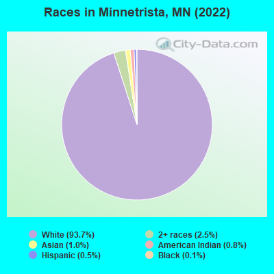
Races in Minnetrista detailed stats: ancestries, foreign born residents, place of birth
Type |
2009 |
2010 |
2011 |
2012 |
2013 |
2014 |
2015 |
2016 |
2017 |
2018 |
2019 |
2020 |
2021 |
2022 |
|---|---|---|---|---|---|---|---|---|---|---|---|---|---|---|
| Murders (per 100,000) | 0 (0.0) | 0 (0.0) | 0 (0.0) | 1 (11.3) | 0 (0.0) | 0 (0.0) | 0 (0.0) | 0 (0.0) | 0 (0.0) | 0 (0.0) | 0 (0.0) | 0 (0.0) | 0 (0.0) | 1 (9.1) |
| Rapes (per 100,000) | 1 (11.6) | 0 (0.0) | 2 (22.9) | 1 (11.3) | 0 (0.0) | 1 (10.8) | 4 (42.8) | 0 (0.0) | 1 (10.0) | 1 (9.7) | 0 (0.0) | 2 (18.6) | 2 (18.0) | 2 (18.2) |
| Robberies (per 100,000) | 0 (0.0) | 0 (0.0) | 0 (0.0) | 0 (0.0) | 0 (0.0) | 0 (0.0) | 0 (0.0) | 0 (0.0) | 1 (10.0) | 0 (0.0) | 1 (9.5) | 0 (0.0) | 0 (0.0) | 0 (0.0) |
| Assaults (per 100,000) | 5 (58.2) | 4 (46.2) | 2 (22.9) | 0 (0.0) | 3 (32.9) | 1 (10.8) | 1 (10.7) | 2 (20.7) | 4 (40.1) | 3 (29.0) | 2 (19.0) | 4 (37.3) | 1 (9.0) | 1 (9.1) |
| Burglaries (per 100,000) | 12 (139.7) | 10 (115.4) | 17 (194.6) | 11 (124.3) | 13 (142.6) | 3 (32.5) | 11 (117.8) | 6 (62.0) | 19 (190.7) | 13 (125.5) | 7 (66.5) | 5 (46.6) | 11 (99.1) | 10 (91.2) |
| Thefts (per 100,000) | 72 (838.4) | 70 (807.7) | 99 (1,134) | 76 (859.1) | 43 (471.5) | 62 (671.4) | 57 (610.3) | 73 (754.5) | 97 (973.4) | 67 (646.9) | 63 (598.5) | 43 (400.4) | 73 (658.0) | 63 (574.9) |
| Auto thefts (per 100,000) | 6 (69.9) | 2 (23.1) | 3 (34.3) | 2 (22.6) | 0 (0.0) | 3 (32.5) | 5 (53.5) | 5 (51.7) | 3 (30.1) | 4 (38.6) | 5 (47.5) | 2 (18.6) | 6 (54.1) | 2 (18.2) |
| Arson (per 100,000) | 0 (0.0) | 0 (0.0) | 0 (0.0) | 0 (0.0) | 0 (0.0) | 0 (0.0) | 0 (0.0) | 0 (0.0) | 0 (0.0) | 0 (0.0) | 0 (0.0) | 0 (0.0) | 0 (0.0) | 0 (0.0) |
| City-Data.com crime index | 69.9 | 51.5 | 84.6 | 76.5 | 35.4 | 42.6 | 73.3 | 42.8 | 73.8 | 51.3 | 39.0 | 43.1 | 53.8 | 65.5 |
The City-Data.com crime index weighs serious crimes and violent crimes more heavily. Higher means more crime, U.S. average is 246.1. It adjusts for the number of visitors and daily workers commuting into cities.
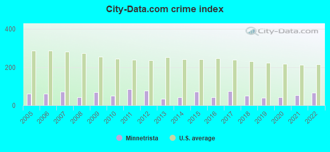
Crime rate in Minnetrista detailed stats: murders, rapes, robberies, assaults, burglaries, thefts, arson
Full-time law enforcement employees in 2021, including police officers: 17 (13 officers - 12 male; 1 female).
| Officers per 1,000 residents here: | 1.17 |
| Minnesota average: | 1.76 |
 Recent articles from our blog. Our writers, many of them Ph.D. graduates or candidates, create easy-to-read articles on a wide variety of topics.

 | Wayzata vs Excelsior, which is better for living? (10 replies) |
| Another boring relocation thread... specific questions about Victoria. (24 replies) |
| Moving from SoCal to Minneapolis (30 replies) |
| which suburb best for young family Eagan, Prior Lake, etc. (37 replies) |
| Hidden Gems (10 replies) |
| Best Towns Outside Twin Cities for Living (28 replies) |
Latest news from Minnetrista, MN collected exclusively by city-data.com from local newspapers, TV, and radio stations
Ancestries: German (30.6%), Norwegian (13.1%), Irish (6.5%), Scandinavian (5.9%), Austrian (5.8%), American (4.6%).
Current Local Time: CST time zone
Elevation: 1012 feet
Land area: 26.1 square miles.
Population density: 332 people per square mile (very low).
234 residents are foreign born (1.4% Europe, 1.1% Asia).
| This city: | 2.8% |
| Minnesota: | 8.5% |
Median real estate property taxes paid for housing units with mortgages in 2022: $5,479 (0.9%)
Median real estate property taxes paid for housing units with no mortgage in 2022: $5,181 (0.9%)
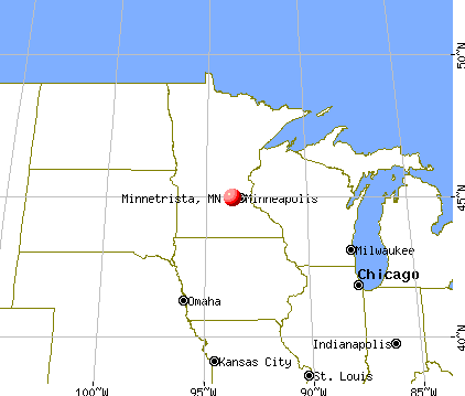
Nearest city with pop. 50,000+: Minnetonka, MN  (12.0 miles , pop. 51,301).
Nearest city with pop. 200,000+: Minneapolis, MN (21.6 miles , pop. 382,618).
Nearest city with pop. 1,000,000+: Chicago, IL (370.4 miles , pop. 2,896,016).
Nearest cities:
), ), )Latitude: 44.93 N, Longitude: 93.71 W
Minnetrista, Minnesota accommodation & food services, waste management - Economy and Business Data
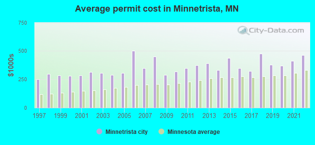
Single-family new house construction building permits:
- 2022: 105 buildings, average cost: $461,500
- 2021: 116 buildings, average cost: $414,200
- 2020: 149 buildings, average cost: $371,100
- 2019: 143 buildings, average cost: $378,100
- 2018: 110 buildings, average cost: $476,200
- 2017: 76 buildings, average cost: $324,900
- 2016: 104 buildings, average cost: $350,200
- 2015: 86 buildings, average cost: $437,900
- 2014: 103 buildings, average cost: $330,400
- 2013: 39 buildings, average cost: $389,700
- 2012: 33 buildings, average cost: $374,900
- 2011: 29 buildings, average cost: $347,900
- 2010: 21 buildings, average cost: $317,300
- 2009: 39 buildings, average cost: $291,200
- 2008: 36 buildings, average cost: $453,200
- 2007: 57 buildings, average cost: $349,500
- 2006: 63 buildings, average cost: $502,600
- 2005: 103 buildings, average cost: $304,800
- 2004: 127 buildings, average cost: $290,600
- 2003: 164 buildings, average cost: $308,400
- 2002: 106 buildings, average cost: $316,400
- 2001: 68 buildings, average cost: $287,300
- 2000: 59 buildings, average cost: $278,600
- 1999: 54 buildings, average cost: $283,300
- 1998: 36 buildings, average cost: $298,500
- 1997: 43 buildings, average cost: $253,100
| Here: | 2.2% |
| Minnesota: | 2.6% |
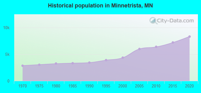
Population change in the 1990s: +871 (+25.0%).
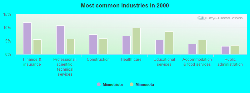
- Finance & insurance (11.9%)
- Professional, scientific, technical services (10.8%)
- Construction (7.5%)
- Health care (6.9%)
- Educational services (5.4%)
- Accommodation & food services (3.8%)
- Public administration (3.0%)
- Construction (13.0%)
- Professional, scientific, technical services (9.6%)
- Finance & insurance (9.6%)
- Machinery (3.7%)
- Groceries & related products merchant wholesalers (3.5%)
- Real estate & rental & leasing (3.5%)
- Health care (3.3%)
- Finance & insurance (15.1%)
- Professional, scientific, technical services (12.5%)
- Health care (11.8%)
- Educational services (9.5%)
- Accommodation & food services (6.5%)
- Administrative & support & waste management services (3.4%)
- Public administration (3.2%)

- Sales representatives, services, wholesale and manufacturing (8.5%)
- Top executives (6.9%)
- Other sales and related occupations, including supervisors (5.8%)
- Other office and administrative support workers, including supervisors (4.7%)
- Other management occupations, except farmers and farm managers (4.3%)
- Retail sales workers, except cashiers (4.1%)
- Building and grounds cleaning and maintenance occupations (3.8%)

- Sales representatives, services, wholesale and manufacturing (11.7%)
- Top executives (8.8%)
- Other sales and related occupations, including supervisors (6.6%)
- Building and grounds cleaning and maintenance occupations (5.7%)
- Other management occupations, except farmers and farm managers (3.9%)
- Supervisors, construction and extraction workers (3.6%)
- Operations specialties managers, except financial managers (3.5%)

- Other office and administrative support workers, including supervisors (7.4%)
- Retail sales workers, except cashiers (5.5%)
- Other management occupations, except farmers and farm managers (4.9%)
- Registered nurses (4.8%)
- Other sales and related occupations, including supervisors (4.7%)
- Secretaries and administrative assistants (4.7%)
- Accountants and auditors (4.6%)
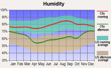
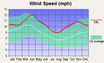
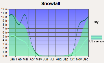
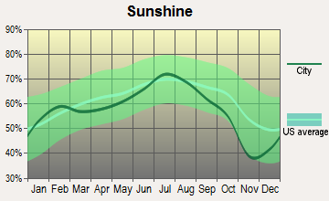
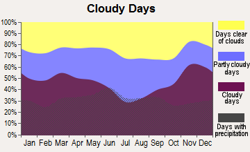
Average climate in Minnetrista, Minnesota
Based on data reported by over 4,000 weather stations
(lower is better)
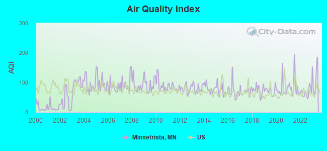
Air Quality Index (AQI) level in 2022 was 66.0. This is about average.
| City: | 66.0 |
| U.S.: | 72.6 |
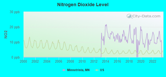
Nitrogen Dioxide (NO2) [ppb] level in 2022 was 11.7. This is significantly worse than average. Closest monitor was 14.3 miles away from the city center.
| City: | 11.7 |
| U.S.: | 5.1 |
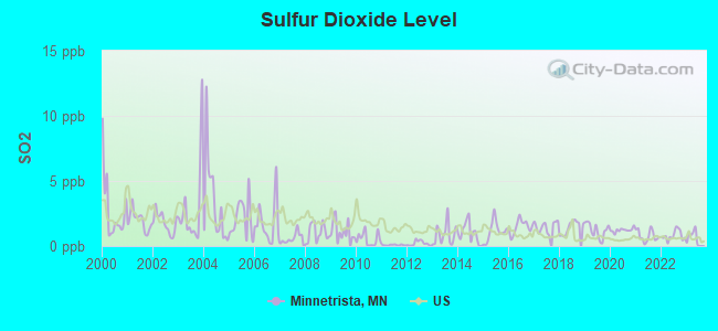
Sulfur Dioxide (SO2) [ppb] level in 2022 was 0.804. This is significantly better than average. Closest monitor was 14.3 miles away from the city center.
| City: | 0.804 |
| U.S.: | 1.515 |
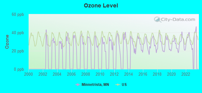
Ozone [ppb] level in 2022 was 30.7. This is about average. Closest monitor was 13.3 miles away from the city center.
| City: | 30.7 |
| U.S.: | 33.3 |
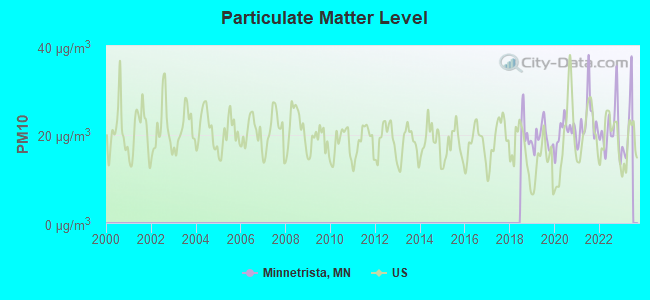
Particulate Matter (PM10) [µg/m3] level in 2022 was 20.8. This is about average. Closest monitor was 15.8 miles away from the city center.
| City: | 20.8 |
| U.S.: | 19.2 |
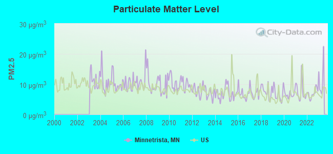
Particulate Matter (PM2.5) [µg/m3] level in 2022 was 6.94. This is about average. Closest monitor was 13.3 miles away from the city center.
| City: | 6.94 |
| U.S.: | 8.11 |
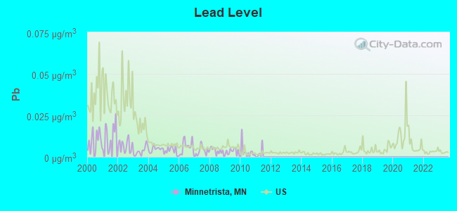
Lead (Pb) [µg/m3] level in 2010 was 0.00286. This is significantly better than average. Closest monitor was 10.1 miles away from the city center.
| City: | 0.00286 |
| U.S.: | 0.00931 |
Tornado activity:
Minnetrista-area historical tornado activity is slightly above Minnesota state average. It is 28% greater than the overall U.S. average.
On 5/6/1965, a category F4 (max. wind speeds 207-260 mph) tornado 3.3 miles away from the Minnetrista city center killed 3 people and injured 175 people and caused between $5,000,000 and $50,000,000 in damages.
On 5/6/1965, a category F4 tornado 8.8 miles away from the city center caused between $5,000,000 and $50,000,000 in damages.
Earthquake activity:
Minnetrista-area historical earthquake activity is significantly above Minnesota state average. It is 52% smaller than the overall U.S. average.On 7/9/1975 at 14:54:15, a magnitude 4.6 (4.6 MB, Class: Light, Intensity: IV - V) earthquake occurred 124.7 miles away from Minnetrista center
On 6/5/1993 at 01:24:53, a magnitude 4.1 (4.1 LG, Depth: 6.2 mi) earthquake occurred 136.1 miles away from Minnetrista center
On 3/4/1983 at 06:32:18, a magnitude 4.6 (4.4 MB, 4.6 LG, 4.4 ML) earthquake occurred 285.2 miles away from the city center
On 10/20/1995 at 15:57:18, a magnitude 3.7 (3.7 LG, Depth: 3.1 mi, Class: Light, Intensity: II - III) earthquake occurred 164.6 miles away from Minnetrista center
On 2/9/1994 at 08:45:35, a magnitude 3.1 (3.1 LG, Depth: 3.1 mi) earthquake occurred 63.5 miles away from the city center
On 11/3/2002 at 20:41:56, a magnitude 4.3 (4.3 MB, Depth: 3.1 mi) earthquake occurred 298.7 miles away from Minnetrista center
Magnitude types: regional Lg-wave magnitude (LG), body-wave magnitude (MB), local magnitude (ML)
Natural disasters:
The number of natural disasters in Hennepin County (17) is near the US average (15).Major Disasters (Presidential) Declared: 12
Emergencies Declared: 4
Causes of natural disasters: Floods: 11, Storms: 8, Tornadoes: 4, Winds: 3, Drought: 1, Hurricane: 1, Landslide: 1, Mudslide: 1, Other: 2 (Note: some incidents may be assigned to more than one category).
Hospitals and medical centers near Minnetrista:
- LAKE MINNETONKA SHORES (Nursing Home, about 4 miles away; SPRING PARK, MN)
- TWIN BIRCH HLTH CARE CTR (Nursing Home, about 4 miles away; SPRING PARK, MN)
- MOUNT OLIVET ROLLING ACRES (Hospital, about 5 miles away; VICTORIA, MN)
- COMMUNITY LIVING INC COTTAGE 4 (Hospital, about 6 miles away; VICTORIA, MN)
- HAVEN HOMES OF MAPLE PLAIN (Nursing Home, about 6 miles away; MAPLE PLAIN, MN)
- FRESENIUS MEDICAL CARE - WACONIA DIALYSIS (Dialysis Facility, about 7 miles away; WACONIA, MN)
- RIDGEVIEW HOME CARE SERVICES (Home Health Center, about 7 miles away; WACONIA, MN)
located in Minnetrista:
See details about located in Minnetrista, MNColleges/universities with over 2000 students nearest to Minnetrista:
- Hennepin Technical College (about 20 miles; Brooklyn Park, MN; Full-time enrollment: 4,515)
- Normandale Community College (about 20 miles; Bloomington, MN; FT enrollment: 7,048)
- North Hennepin Community College (about 21 miles; Brooklyn Park, MN; FT enrollment: 4,943)
- Minneapolis Community and Technical College (about 21 miles; Minneapolis, MN; FT enrollment: 6,726)
- Capella University (about 22 miles; Minneapolis, MN; FT enrollment: 21,718)
- Walden University (about 22 miles; Minneapolis, MN; FT enrollment: 62,473)
- Augsburg College (about 23 miles; Minneapolis, MN; FT enrollment: 2,954)
Public high schools in Minnetrista:
- 277 WESTONKA AREA LEARNING ACADEMY (Location: 5901 SUNNYFIELD RD E, Grades: 9-12)
- ALC WESTONKA - IS (Location: 5905 SUNNYFIELD RD E, Grades: 8-12)
- MOUND-WESTONKA HIGH SCHOOL (Location: 5905 SUNNYFIELD RD E, Grades: 8-12)
Public elementary/middle school in Minnetrista:
- HILLTOP PRIMARY SCHOOL (Location: 5700 GAME FARM RD, Grades: PK-4)
Points of interest:
Notable locations in Minnetrista: Red Oak Golf Course (A), Burr Oaks Golf Club (B), Kingswood Camp (C), Minnetonka Orchards (D), Christmas Tree Camp (E), Boll Farm (F), Saint Bonifacius Fire Department (G). Display/hide their locations on the map
Church in Minnetrista: Freshwater Community Church (A). Display/hide its location on the map
Cemeteries: Saint Bonifacius Catholic Church Cemetery (1), German Baptist Cemetery (2), Union Cemetery (3), Mound Cemetery (4), Minnestrista Cemetery (5), Halsted Family Cemetery (6). Display/hide their locations on the map
Lakes: Whaletail Lake (A), Ox Yoke Lake (B), Mud Lake (C), Long Lake (D), Dutch Lake (E). Display/hide their locations on the map
Creeks: Pioneer Creek (A), Sixmile Creek (B), Painter Creek (C). Display/hide their locations on the map
Park in Minnetrista: Lake Minnetonka Regional Park (1). Display/hide its location on the map
| This city: | 2.9 people |
| Minnesota: | 2.5 people |
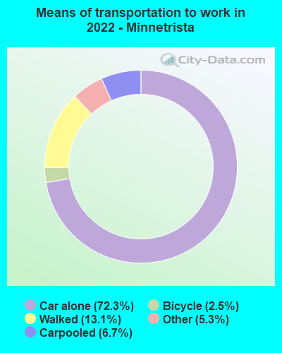
| This city: | 83.8% |
| Whole state: | 64.6% |
| This city: | 4.4% |
| Whole state: | 6.9% |
Likely homosexual households (counted as self-reported same-sex unmarried-partner households)
- Lesbian couples: 0.1% of all households
- Gay men: 0.3% of all households
For population 15 years and over in Minnetrista:
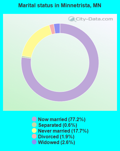
- Never married: 17.7%
- Now married: 77.2%
- Separated: 0.6%
- Widowed: 2.6%
- Divorced: 1.9%
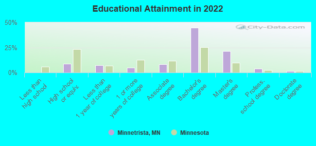
For population 25 years and over in Minnetrista:
- High school or higher: 100.0%
- Bachelor's degree or higher: 70.7%
- Graduate or professional degree: 26.2%
- Unemployed: 2.1%
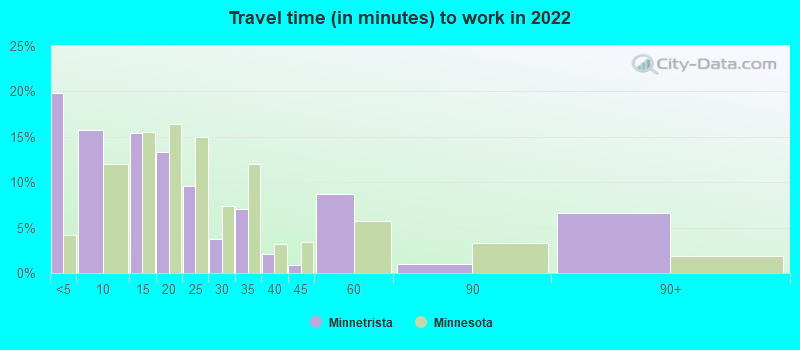
- Mean travel time to work (commute): 15.6 minutes
| Here: | 7.0 |
| Minnesota average: | 10.9 |
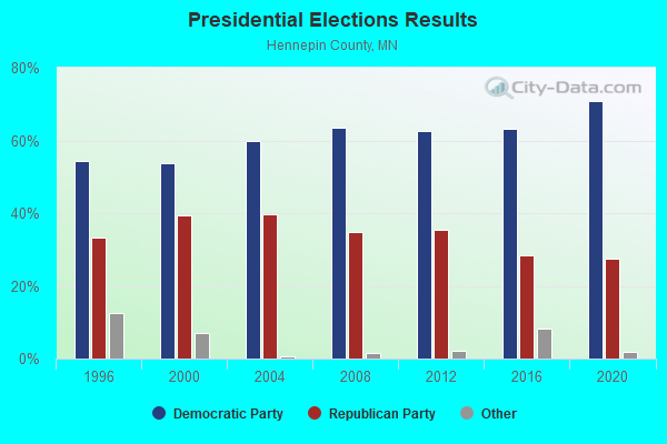
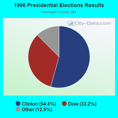
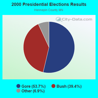
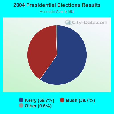
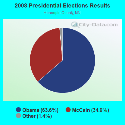
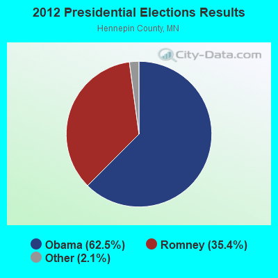
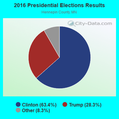
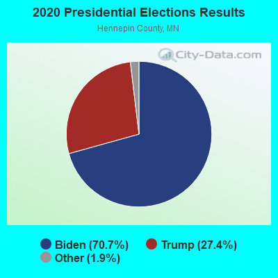
Graphs represent county-level data. Detailed 2008 Election Results
Religion statistics for Minnetrista, MN (based on Hennepin County data)
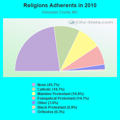
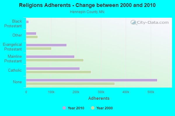
| Religion | Adherents | Congregations |
|---|---|---|
| Catholic | 215,205 | 74 |
| Mainline Protestant | 193,498 | 234 |
| Evangelical Protestant | 162,094 | 393 |
| Other | 41,287 | 110 |
| Black Protestant | 10,812 | 21 |
| Orthodox | 3,337 | 6 |
| None | 526,192 | - |
Food Environment Statistics:
| This county: | 1.79 / 10,000 pop. |
| State: | 1.83 / 10,000 pop. |
| Here: | 0.12 / 10,000 pop. |
| Minnesota: | 0.13 / 10,000 pop. |
| Hennepin County: | 0.69 / 10,000 pop. |
| Minnesota: | 0.49 / 10,000 pop. |
| Hennepin County: | 2.50 / 10,000 pop. |
| Minnesota: | 3.90 / 10,000 pop. |
| Here: | 7.13 / 10,000 pop. |
| Minnesota: | 6.98 / 10,000 pop. |
| This county: | 5.8% |
| Minnesota: | 6.5% |
| Hennepin County: | 22.8% |
| Minnesota: | 25.9% |
| This county: | 15.2% |
| State: | 13.0% |
Health and Nutrition:
| This city: | 47.4% |
| Minnesota: | 50.6% |
| This city: | 43.4% |
| Minnesota: | 48.4% |
| This city: | 29.8 |
| State: | 28.5 |
| Minnetrista: | 25.3% |
| Minnesota: | 21.0% |
| Here: | 18.0% |
| State: | 9.8% |
| Minnetrista: | 6.7 |
| State: | 6.8 |
| Minnetrista: | 41.4% |
| Minnesota: | 33.5% |
| Minnetrista: | 51.6% |
| Minnesota: | 57.7% |
| Here: | 77.3% |
| Minnesota: | 79.3% |
More about Health and Nutrition of Minnetrista, MN Residents
| Local government employment and payroll (March 2022) | |||||
| Function | Full-time employees | Monthly full-time payroll | Average yearly full-time wage | Part-time employees | Monthly part-time payroll |
|---|---|---|---|---|---|
| Police Protection - Officers | 13 | $104,559 | $96,516 | 0 | $0 |
| Other Government Administration | 10 | $34,308 | $41,170 | 0 | $0 |
| Streets and Highways | 6 | $33,355 | $66,710 | 0 | $0 |
| Police - Other | 4 | $15,082 | $45,246 | 0 | $0 |
| Financial Administration | 3 | $19,267 | $77,068 | 0 | $0 |
| Water Supply | 2 | $14,951 | $89,706 | 0 | $0 |
| Other and Unallocable | 2 | $12,249 | $73,494 | 0 | $0 |
| Sewerage | 1 | $6,193 | $74,316 | 0 | $0 |
| Parks and Recreation | 0 | $0 | 1 | $426 | |
| Totals for Government | 41 | $239,964 | $70,233 | 1 | $426 |
Minnetrista government finances - Expenditure in 2017 (per resident):
- Construction - Parks and Recreation: $464,000 ($53.54)
- Current Operations - Police Protection: $1,723,000 ($198.82)
Regular Highways: $1,462,000 ($168.71)
Water Utilities: $885,000 ($102.12)
Sewerage: $839,000 ($96.82)
Central Staff Services: $781,000 ($90.12)
General - Other: $427,000 ($49.27)
Parks and Recreation: $160,000 ($18.46)
Financial Administration: $147,000 ($16.96)
Solid Waste Management: $132,000 ($15.23)
Judicial and Legal Services: $115,000 ($13.27)
General Public Buildings: $81,000 ($9.35)
- Intergovernmental to Local - Other - Local Fire Protection: $485,000 ($55.97)
- Other Capital Outlay - Regular Highways: $213,000 ($24.58)
Police Protection: $123,000 ($14.19)
Central Staff Services: $52,000 ($6.00)
- Total Salaries and Wages: $2,066,000 ($238.40)
- Water Utilities - Interest on Debt: $653,000 ($75.35)
Minnetrista government finances - Revenue in 2017 (per resident):
- Charges - Sewerage: $876,000 ($101.08)
Solid Waste Management: $106,000 ($12.23)
Parks and Recreation: $78,000 ($9.00)
- Local Intergovernmental - General Local Government Support: $23,000 ($2.65)
- Miscellaneous - Special Assessments: $742,000 ($85.62)
General Revenue - Other: $737,000 ($85.05)
Interest Earnings: $128,000 ($14.77)
Fines and Forfeits: $48,000 ($5.54)
Sale of Property: $28,000 ($3.23)
- Revenue - Water Utilities: $944,000 ($108.93)
- State Intergovernmental - Other: $111,000 ($12.81)
Highways: $105,000 ($12.12)
- Tax - Property: $4,157,000 ($479.69)
Other License: $652,000 ($75.24)
Minnetrista government finances - Debt in 2017 (per resident):
- Long Term Debt - Outstanding Unspecified Public Purpose: $25,451,000 ($2936.88)
Beginning Outstanding - Unspecified Public Purpose: $16,334,000 ($1884.84)
Issue, Unspecified Public Purpose: $10,710,000 ($1235.86)
Retired Unspecified Public Purpose: $1,593,000 ($183.82)
Minnetrista government finances - Cash and Securities in 2017 (per resident):
- Bond Funds - Cash and Securities: $8,264,000 ($953.61)
- Other Funds - Cash and Securities: $13,530,000 ($1561.27)
6.75% of this county's 2021 resident taxpayers lived in other counties in 2020 ($70,758 average adjusted gross income)
| Here: | 6.75% |
| Minnesota average: | 7.43% |
0.00% of residents moved from foreign countries ($39 average AGI)
Hennepin County: 0.00% Minnesota average: 0.00%
Top counties from which taxpayers relocated into this county between 2020 and 2021:
| from Ramsey County, MN | |
| from Anoka County, MN | |
| from Dakota County, MN |
8.44% of this county's 2020 resident taxpayers moved to other counties in 2021 ($85,733 average adjusted gross income)
| Here: | 8.44% |
| Minnesota average: | 7.79% |
0.01% of residents moved to foreign countries ($68 average AGI)
Hennepin County: 0.01% Minnesota average: 0.00%
Top counties to which taxpayers relocated from this county between 2020 and 2021:
| to Ramsey County, MN | |
| to Anoka County, MN | |
| to Dakota County, MN |
Strongest AM radio stations in Minnetrista:
- KWOM (1600 AM; 5 kW; WATERTOWN, MN; Owner: WATERTOWN RADIO, INC.)
- WCCO (830 AM; 50 kW; MINNEAPOLIS, MN; Owner: INFINITY MEDIA CORPORATION)
- KFAN (1130 AM; 50 kW; MINNEAPOLIS, MN; Owner: AMFM RADIO LICENSES, L.L.C.)
- KSMM (1530 AM; 9 kW; SHAKOPEE, MN; Owner: STARBOARD BROADCASTING, INC.)
- KSTP (1500 AM; 50 kW; ST. PAUL, MN; Owner: KSTP-AM, LLC (DELAWARE))
- WCTS (1030 AM; 50 kW; MAPLEWOOD, MN; Owner: CNTL. BAPT. THEO/AL SEMI MINNEAPOLIS)
- KTIS (900 AM; 25 kW; MINNEAPOLIS, MN; Owner: NORTHWESTERN COLLEGE)
- WMNN (1330 AM; 10 kW; MINNEAPOLIS, MN; Owner: MINNESOTA PUBLIC RADIO.)
- WWTC (1280 AM; 5 kW; MINNEAPOLIS, MN; Owner: SCA LICENSE CORPORATION)
- KDIZ (1440 AM; 5 kW; GOLDEN VALLEY, MN; Owner: KQRS, INC.)
- KUOM (770 AM; daytime; 5 kW; MINNEAPOLIS, MN)
- KLBP (1470 AM; 5 kW; BROOKLYN PARK, MN; Owner: 1400, INC.)
- KYCR (1570 AM; 4 kW; GOLDEN VALLEY, MN; Owner: COMMON GROUND BROADCASTING COMPANY,)
Strongest FM radio stations in Minnetrista:
- KTTB (96.3 FM; GLENCOE, MN; Owner: BLUE CHIP BROADCASTING LICENSES II, LTD.)
- KTCZ-FM (97.1 FM; MINNEAPOLIS, MN; Owner: AMFM RADIO LICENSES, L.L.C.)
- KQQL (107.9 FM; ANOKA, MN; Owner: AMFM RADIO LICENSES, L.L.C.)
- KNOW-FM (91.1 FM; MINNEAPOLIS-ST. PAUL, MN; Owner: MINNESOTA PUBLIC RADIO)
- WLTE (102.9 FM; MINNEAPOLIS, MN; Owner: INFINITY MEDIA CORPORATION)
- KSTP-FM (94.5 FM; ST. PAUL, MN; Owner: KSTP-FM, LLC, A DELAWARE LLC)
- KEEY-FM (102.1 FM; ST. PAUL, MN; Owner: AMFM RADIO LICENSES, L.L.C.)
- KTIS-FM (98.5 FM; MINNEAPOLIS, MN; Owner: NORTHWESTERN COLLEGE)
- KDWB-FM (101.3 FM; RICHFIELD, MN; Owner: AMFM RADIO LICENSES, L.L.C.)
- KQRS-FM (92.5 FM; GOLDEN VALLEY, MN; Owner: KQRS, Inc.)
- KSJN (99.5 FM; MINNEAPOLIS, MN; Owner: MINNESOTA PUBLIC RADIO)
- KXXR (93.7 FM; MINNEAPOLIS, MN; Owner: KQRS, INC.)
- KJZI (100.3 FM; MINNEAPOLIS, MN; Owner: AMFM RADIO LICENSES, L.L.C.)
- K214DF (90.7 FM; GOLDEN VALLEY, MN; Owner: EDUCATIONAL MEDIA FOUNDATION)
- WGVZ (105.7 FM; EDEN PRAIRIE, MN; Owner: KQRS, INC.)
- KFAI (90.3 FM; MINNEAPOLIS, MN; Owner: FRESH AIR, INC.)
- WCAL (89.3 FM; NORTHFIELD, MN; Owner: ST. OLAF COLLEGE)
- KBEM-FM (88.5 FM; MINNEAPOLIS, MN; Owner: BD. OF EDUCATION, S.S.D. NO. 1)
- KLCI (106.1 FM; ELK RIVER, MN; Owner: MILESTONE RADIO LLC)
- KARP-FM (106.9 FM; DASSEL, MN; Owner: IOWA CITY BROADCASTING COMPANY, INC.)
TV broadcast stations around Minnetrista:
- KARE (Channel 11; MINNEAPOLIS, MN; Owner: MULTIMEDIA HOLDINGS CORPORATION)
- KSTP-TV (Channel 5; ST. PAUL, MN; Owner: HUBBARD BROADCASTING, INC.)
- KMSP-TV (Channel 9; MINNEAPOLIS, MN; Owner: FOX TELEVISION STATIONS, INC.)
- KTCA-TV (Channel 2; ST. PAUL, MN; Owner: TWIN CITIES PUBLIC TELEVISION, INC.)
- K07UI (Channel 7; MINNEAPOLIS, ETC., MN; Owner: WORD OF GOD FELLOWSHIP, INC.)
- WCCO-TV (Channel 4; MINNEAPOLIS, MN; Owner: CBS BROADCASTING INC.)
- KPXM (Channel 41; ST. CLOUD, MN; Owner: PAXSON MINNEAPOLIS LICENSE, INC.)
- KSTC-TV (Channel 45; MINNEAPOLIS, MN; Owner: HUBBARD BROADCASTING, INC.)
- KTCI-TV (Channel 17; ST. PAUL, MN; Owner: TWIN CITIES PUBLIC TELEVISION, INC.)
- K58BS (Channel 58; MINNEAPOLIS, MN; Owner: TRINITY BROADCASTING NETWORK)
- K67HG (Channel 67; MINNEAPOLIS, MN; Owner: VENTANA TELEVISION, INC.)
- KMWB (Channel 23; MINNEAPOLIS, MN; Owner: KLGT LICENSEE, LLC)
- K14KH (Channel 14; MINNEAPOLIS, MN; Owner: THREE ANGELS BROADCASTING NETWORK)
- K19ER (Channel 19; ST. PAUL, MN; Owner: CATHOLIC VIEWS BROADCASTS, INC.)
- W62BD (Channel 62; MINNEAPOLIS, MN; Owner: WORD OF GOD FELLOWSHIP, INC.)
- WFTC (Channel 29; MINNEAPOLIS, MN; Owner: FOX TELEVISION STATIONS, INC.)
- WBWX-CA (Channel 13; MINNEAPOLIS, MN; Owner: THE BOX WORLDWIDE LLC)
Minnetrista fatal accident list:
Nov 29, 2019 08:45 PM, Cr-92, Lat: 44.945358, Lon: -93.747008, Vehicles: 2, Persons: 2, Fatalities: 1
Oct 29, 2017 02:12 PM, Sr-7, Lat: 44.892614, Lon: -93.679239, Vehicles: 2, Persons: 3, Fatalities: 1
Sep 13, 2014 02:57 PM, Cr-26, North Branch Road/Ingerson Rd, Lat: 44.973347, Lon: -93.696347, Vehicles: 3, Persons: 5, Fatalities: 1
Aug 8, 2007 09:26 PM, 44 0427000044, 3800 Cr 44, Lat: 44.909389, Lon: -93.678322, Vehicles: 2, Persons: 6, Fatalities: 1, Drunk persons involved: 2
Feb 24, 2001 08:24 PM, Sr-7, Vehicles: 2, Persons: 3, Fatalities: 1
Mar 9, 1998 11:17 AM, Sr-7, Vehicles: 2, Persons: 4, Fatalities: 1
- National Bridge Inventory (NBI) Statistics
- 6Number of bridges
- 33ft / 9.9mTotal length
- $1,000Total costs
- 27,082Total average daily traffic
- 1,015Total average daily truck traffic
- 28,140Total future (year 2029) average daily traffic
FCC Registered Cell Phone Towers:
1- 2900 Highland Drive (1655) (Lat: 44.926389 Lon: -93.736389), Type: Mtower, Structure height: 71 m, Overall height: 75.6 m, Call Sign: KNKA247
Assigned Frequencies: 869.040 MHz, 869.040 MHz, 869.040 MHz, 824.040 MHz, 824.040 MHz, 824.040 MHz, 890.010 MHz, 890.010 MHz, 890.010 MHz, 845.010 MHz, 845.010 MHz, 845.010 MHzGrant Date: 09/03/2014, Expiration Date: 10/01/2024, Certifier: Michael P GogginRegistrant: At&t Services, Inc., 208 S Akard St, 20f, Dallas, TX 75202, Phone: (855) 699-7073, Fax: (214) 746-6410, Email:
FCC Registered Antenna Towers:
1- 2900 Highland Drive (Lat: 44.926389 Lon: -93.736389), Type: 75.6, Overall height: 70.9 m, Registrant: West Central Educational Television Corporation, Jpanzer @ Pioneer, , Apple-ton, Phone: (320) 289-2622
FCC Registered Broadcast Land Mobile Towers:
7- 7701 Cr 110 W (Lat: 44.923028 Lon: -93.719417), Call Sign: WNRB542, Licensee ID: L00001748,
Assigned Frequencies: 154.355 MHz, Grant Date: 10/08/2004, Expiration Date: 01/03/2015, Cancellation Date: 06/08/2012, Registrant: County Of Hennepin, 9300 Naper St, Golden Valley, MN 55427-3728, Phone: (612) 596-1923
- 7701 Cr 110 W (Lat: 44.923028 Lon: -93.719417), Call Sign: WNQZ848, Licensee ID: L00001748,
Assigned Frequencies: 154.995 MHz, 155.055 MHz, 155.805 MHz, Grant Date: 10/08/2004, Expiration Date: 01/05/2015, Cancellation Date: 06/08/2012, Registrant: County Of Hennepin, 9300 Naper St, Golden Valley, MN 55427-3728, Phone: (612) 596-1923
- 7701 Cr 110 W (Lat: 44.923028 Lon: -93.719417), Call Sign: WNQZ846, Licensee ID: L00001748,
Assigned Frequencies: 154.830 MHz, Grant Date: 10/08/2004, Expiration Date: 01/05/2015, Cancellation Date: 06/08/2012, Registrant: County Of Hennepin, 9300 Naper St, Golden Valley, MN 55427-3728, Phone: (612) 596-1923
- 2900 Highland Drv-Minnetrista Pole (Lat: 44.926361 Lon: -93.736361), Type: Tower, Structure height: 70 m, Overall height: 75 m, Call Sign: WPKK355,
Assigned Frequencies: 851.962 MHz, 852.262 MHz, 852.862 MHz, 853.637 MHz, 852.612 MHz, 853.887 MHz, Grant Date: 01/08/2022, Expiration Date: 03/20/2032, Certifier: King W Fung, Registrant: County Of Hennepin, 1245 Shenandoah Lane N, Plymouth, MN 55447, Phone: (612) 596-1296, Fax: (612) 313-3654, Email:
- 5890 Sunny Field Road East (Lat: 44.958333 Lon: -93.670556), Type: Bant, Structure height: 6 m, Call Sign: WPSZ473,
Assigned Frequencies: 451.037 MHz, Grant Date: 10/01/2021, Expiration Date: 08/13/2031, Certifier: Ronald G Fuchs, Registrant: Business Radio Licensing, 30251 Golden Lantern, Suite E #501, Laguna Niguel, CA 92677, Phone: (949) 348-8510, Fax: (949) 348-8514, Email:
- MINNETRISTA, 2900 Highland Drv-Minnetrista Pole (Lat: 44.926389 Lon: -93.736389), Type: Tower, Structure height: 70.9 m, Overall height: 75.6 m, Call Sign: WQMZ724,
Assigned Frequencies: 854.312 MHz, 851.412 MHz, 851.912 MHz, 852.412 MHz, 852.912 MHz, 853.412 MHz, Grant Date: 08/27/2020, Expiration Date: 11/17/2030, Certifier: Dave Pagel, Registrant: Electronic Communications Office, 1500 W Cr B2, Ms730, Roseville, MN 55113, Phone: (651) 234-7972, Fax: (651) 234-7960, Email:
- Lat: 44.973389 Lon: -93.665250, Call Sign: WQPB961,
Assigned Frequencies: 151.955 MHz, 160.170 MHz, 461.512 MHz, 466.512 MHz, 159.810 MHz, Grant Date: 04/08/2022, Expiration Date: 04/02/2032, Certifier: Nathan C Peters, Registrant: Mobile Radio Engineering, Inc., 745 Boone Avenue, North, Golden Valley, MN 55427, Phone: (763) 544-3319, Fax: (763) 544-2078, Email:
FCC Registered Microwave Towers:
6- Minnestrista, 2900 Highland Dr. (Lat: 44.926389 Lon: -93.736389), Type: Tower, Structure height: 70.9 m, Overall height: 75.6 m, Call Sign: WPQN786,
Assigned Frequencies: 11035.0 MHz, 10755.0 MHz, Grant Date: 04/21/2020, Expiration Date: 06/30/2030, Certifier: Signature On File, Registrant: Minnesota Department Of Transportation, 395 John Ireland Blvd Ms730, Saint Paul, MN 55155, Phone: (651) 234-7961, Fax: (651) 234-7960, Email:
- MSPHGH, 2900 Highland Drive (Lat: 44.926389 Lon: -93.736389), Type: Tower, Structure height: 70.9 m, Overall height: 75.6 m, Call Sign: WQJR392,
Assigned Frequencies: 11185.0 MHz, 11185.0 MHz, 11185.0 MHz, 11137.5 MHz, Grant Date: 12/02/2008, Expiration Date: 12/02/2018, Cancellation Date: 02/16/2019, Certifier: Kurt Maass, Registrant: Telecom Transport Management, Inc., 146 N. Canal Street, Suite 210, Seattle, WA 98103, Phone: (206) 816-6907, Fax: (206) 545-9585, Email:
- MSP70V, 4701 Kings Point Rd (Lat: 44.894694 Lon: -93.701389), Type: Tank, Structure height: 25.6 m, Call Sign: WQNE230,
Assigned Frequencies: 11095.0 MHz, 11095.0 MHz, Grant Date: 01/05/2011, Expiration Date: 01/05/2021, Cancellation Date: 03/13/2021, Certifier: Alexis Diaz, Registrant: Telecom Transport Management, Inc., 146 N. Canal Street, Suite 210, Seattle, WA 98103, Phone: (206) 816-6907, Fax: (206) 545-9585, Email:
- A1P0918A, 4700 Merrywood Lane (Lat: 44.891833 Lon: -93.667028), Type: Pole, Structure height: 57.9 m, Call Sign: WQPR945,
Assigned Frequencies: 17815.0 MHz, 17815.0 MHz, 17815.0 MHz, 17815.0 MHz, 17815.0 MHz, 17815.0 MHz, 17815.0 MHz, 17815.0 MHz, 17815.0 MHz, 17815.0 MHz, Grant Date: 09/15/2022, Expiration Date: 07/31/2032, Cancellation Date: 01/08/2024, Certifier: Dan Menser, Registrant: T-Mobile Usa, Inc., 12920 Se 38th St, Bellevue, WA 98006, Phone: (425) 383-8401, Fax: (425) 383-4040, Email:
- MS63XC340, 4700 Merrywood Ln (Lat: 44.891722 Lon: -93.666944), Type: Mtower, Structure height: 54.6 m, Call Sign: WQSV666,
Assigned Frequencies: 11305.0 MHz, 11345.0 MHz, Grant Date: 11/22/2013, Expiration Date: 11/22/2023, Cancellation Date: 05/10/2023, Certifier: David Werblow, Registrant: T-Mobile Usa, Inc., 12920 Se 38th Street, Bellevue, WA 98006, Phone: (425) 383-8401, Email:
- STATION, 2.4 Mile Nne Of St. Bonifacius (Lat: 44.926333 Lon: -93.736056), Structure height: 124.1 m, Overall height: 69.8 m, Call Sign: WEE826,
Assigned Frequencies: 2183.20 MHz, Grant Date: 12/14/2000, Expiration Date: 02/28/2011, Cancellation Date: 10/25/2006, Phone: (612) 525-6232
FCC Registered Amateur Radio Licenses:
12 (See the full list of FCC Registered Amateur Radio Licenses in Minnetrista)FAA Registered Aircraft:
9 (See the full list of FAA Registered Aircraft in Minnetrista)| Home Mortgage Disclosure Act Aggregated Statistics For Year 2009 (Based on 1 full tract) | ||||||||||
| A) FHA, FSA/RHS & VA Home Purchase Loans | B) Conventional Home Purchase Loans | C) Refinancings | D) Home Improvement Loans | F) Non-occupant Loans on < 5 Family Dwellings (A B C & D) | ||||||
|---|---|---|---|---|---|---|---|---|---|---|
| Number | Average Value | Number | Average Value | Number | Average Value | Number | Average Value | Number | Average Value | |
| LOANS ORIGINATED | 46 | $240,674 | 73 | $279,616 | 354 | $286,040 | 16 | $222,812 | 17 | $309,059 |
| APPLICATIONS APPROVED, NOT ACCEPTED | 3 | $216,667 | 5 | $267,200 | 45 | $281,822 | 0 | $0 | 1 | $417,000 |
| APPLICATIONS DENIED | 4 | $242,250 | 9 | $318,222 | 98 | $341,663 | 7 | $115,429 | 5 | $329,200 |
| APPLICATIONS WITHDRAWN | 6 | $269,167 | 6 | $282,833 | 79 | $309,000 | 3 | $70,000 | 4 | $313,250 |
| FILES CLOSED FOR INCOMPLETENESS | 0 | $0 | 1 | $38,000 | 26 | $341,808 | 1 | $75,000 | 0 | $0 |
Detailed HMDA statistics for the following Tracts: 0277.00
| Private Mortgage Insurance Companies Aggregated Statistics For Year 2009 (Based on 1 full tract) | ||||
| A) Conventional Home Purchase Loans | B) Refinancings | |||
|---|---|---|---|---|
| Number | Average Value | Number | Average Value | |
| LOANS ORIGINATED | 16 | $324,188 | 7 | $280,000 |
| APPLICATIONS APPROVED, NOT ACCEPTED | 2 | $305,000 | 5 | $250,600 |
| APPLICATIONS DENIED | 2 | $292,000 | 1 | $282,000 |
| APPLICATIONS WITHDRAWN | 2 | $359,500 | 0 | $0 |
| FILES CLOSED FOR INCOMPLETENESS | 0 | $0 | 0 | $0 |
Detailed PMIC statistics for the following Tracts: 0277.00
2002 - 2018 National Fire Incident Reporting System (NFIRS) incidents
- Fire incident types reported to NFIRS in Minnetrista, MN
- 12848.9%Structure Fires
- 9134.7%Outside Fires
- 238.8%Mobile Property/Vehicle Fires
- 207.6%Other
 Based on the data from the years 2002 - 2018 the average number of fire incidents per year is 15. The highest number of fire incidents - 28 took place in 2013, and the least - 8 in 2018. The data has a dropping trend.
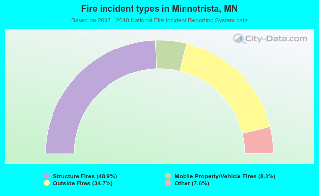 When looking into fire subcategories, the most incidents belonged to: Structure Fires (48.9%), and Outside Fires (34.7%).
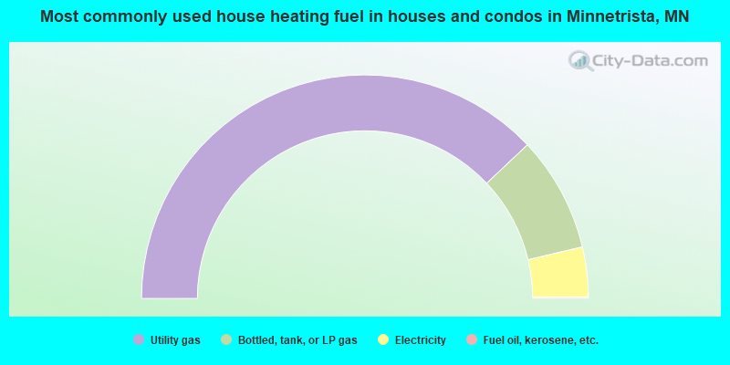
- 75.9%Utility gas
- 16.7%Bottled, tank, or LP gas
- 7.2%Electricity
- 0.2%Fuel oil, kerosene, etc.
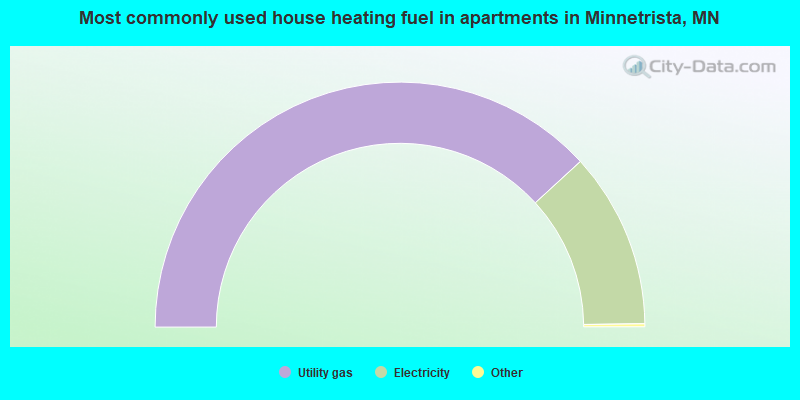
- 76.7%Utility gas
- 23.3%Electricity
Minnetrista compared to Minnesota state average:
- Median household income above state average.
- Median house value above state average.
- Unemployed percentage significantly below state average.
- Black race population percentage significantly below state average.
- Hispanic race population percentage significantly below state average.
- Foreign-born population percentage below state average.
- Renting percentage significantly below state average.
- Length of stay since moving in significantly below state average.
- Number of rooms per house above state average.
- House age below state average.
- Percentage of population with a bachelor's degree or higher significantly above state average.
Minnetrista on our top lists:
- #58 on the list of "Top 101 cities with the most residents born in Afghanistan (population 500+)"
- #73 on the list of "Top 101 cities with largest percentage of males in occupations: management occupations (population 5,000+)"
- #98 on the list of "Top 100 cities with biggest houses (pop. 5,000+)"
- #90 (55364) on the list of "Top 101 zip codes with the largest percentage of Swedish first ancestries (pop 5,000+)"
- #4 on the list of "Top 101 counties with the most Mainline Protestant adherents"
- #7 on the list of "Top 101 counties with the highest percentage of residents that exercised in the past month"
- #10 on the list of "Top 101 counties with the most Mainline Protestant congregations"
- #15 on the list of "Top 101 counties with the highest percentage of residents that visited a dentist within the past year"
- #28 on the list of "Top 101 counties with the best general health status score of residents (1-5), 3 years of data"
State forum archive:

|
|
Total of 169 patent applications in 2008-2024.