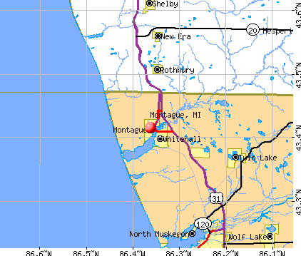
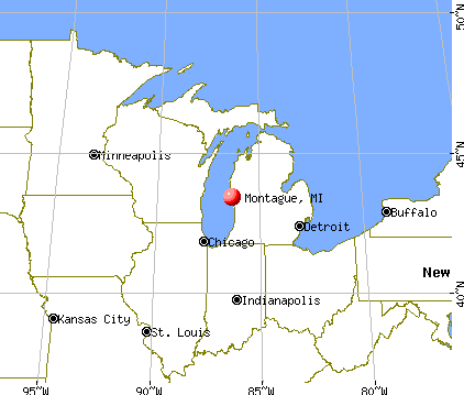
Montague, Michigan
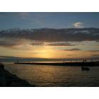
Montague: Montague Pier
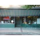
Montague: soda fountain
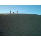
Montague: Three Women on Dunes
Montague
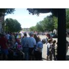
Montague: 4'th of July parade
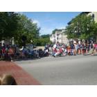
Montague: 4'th of July parade

Montague
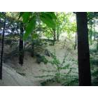
Montague: Silver Lake Dunes

Montague: beach-mother and child

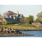
Montague: Conversation on Beach
- see
23
more - add
your
Submit your own pictures of this city and show them to the world
- OSM Map
- General Map
- Google Map
- MSN Map
Population change since 2000: +0.2%
 |
| Males: 1,148 | |
| Females: 1,265 |
| Median resident age: | 36.5 years |
| Michigan median age: | 40.3 years |
Zip codes: 49437.
| Montague: | $66,783 |
| MI: | $66,986 |
Estimated per capita income in 2022: $26,991 (it was $21,238 in 2000)
Montague city income, earnings, and wages data
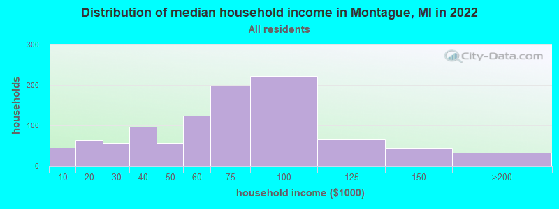
Estimated median house or condo value in 2022: $183,524 (it was $87,700 in 2000)
| Montague: | $183,524 |
| MI: | $224,400 |
Mean prices in 2022: all housing units: $193,510; detached houses: $203,522; townhouses or other attached units: $280,190; in 2-unit structures: $162,964; in 3-to-4-unit structures: $150,363; in 5-or-more-unit structures: $274,283; mobile homes: $55,925
Median gross rent in 2022: $756.
(4.9% for White Non-Hispanic residents, 100.0% for Black residents)
Detailed information about poverty and poor residents in Montague, MI
Compare current foreclosures near Montague, MI:
| Photo | Address | Area | Beds / Baths | Price | Details |
|---|---|---|---|---|---|

|
#1
Anderson Rd
Montague, MI 49437
|
1,974 sq. feet
|
2 baths 3 beds |
show details | |

|
#2
W Webster Rd
Montague, MI 49437
|
- sq. feet
|
2 baths 3 beds |
show details | |

|
#3
Custar St
Montague, MI 49437
|
912 sq. feet
|
1 baths 3 beds |
show details | |

|
#4
Us Highway 31
Montague, MI 49437
|
1,000 sq. feet
|
1 baths - beds |
show details | |

|
#5
Cook St Apt B9
Montague, MI 49437
|
- sq. feet
|
- baths - beds |
show details | |

|
#6
Robinhood Dr
Montague, MI 49437
|
- sq. feet
|
- baths - beds |
show details | |

|
#7
S 72nd Ave
Montague, MI 49437
|
- sq. feet
|
- baths - beds |
show details | |

|
#8
S Quarterline Rd
Muskegon, MI 49442
|
1,310 sq. feet
|
1 baths 3 beds |
show details | |

|
#9
Oak Ave
Muskegon, MI 49442
|
976 sq. feet
|
1 baths 3 beds |
show details | |

|
#10
Mccracken St
Muskegon, MI 49441
|
1,200 sq. feet
|
1 baths 3 beds |
show details |
| Photo | Address | Area | Beds / Baths | Price | Details |
|---|---|---|---|---|---|

|
#11
Sisson St
Muskegon, MI 49441
|
1,235 sq. feet
|
1 baths 4 beds |
show details | |

|
#12
Green St
Muskegon, MI 49442
|
1,167 sq. feet
|
1 baths 3 beds |
show details | |

|
#13
W Barney Ave
Muskegon, MI 49441
|
1,027 sq. feet
|
1 baths 3 beds |
show details | |

|
#14
Lemuel St
Muskegon, MI 49444
|
- sq. feet
|
1 baths 3 beds |
show details | |

|
#15
Langeland Ave
Muskegon, MI 49442
|
1,128 sq. feet
|
1 baths 3 beds |
show details | |

|
#16
Roosevelt Rd
Muskegon, MI 49441
|
1,152 sq. feet
|
1 baths 3 beds |
show details | |

|
#17
Lemuel St
Muskegon, MI 49444
|
816 sq. feet
|
1 baths 2 beds |
show details | |

|
#18
Scott Rd
Twin Lake, MI 49457
|
2,280 sq. feet
|
2 baths 3 beds |
show details | |

|
#19
Lemuel St
Muskegon, MI 49444
|
592 sq. feet
|
1 baths 2 beds |
show details | |

|
#20
Hiawatha Dr
Muskegon, MI 49441
|
1,200 sq. feet
|
1 baths 3 beds |
show details |
| Photo | Address | Area | Beds / Baths | Price | Details |
|---|---|---|---|---|---|

|
#21
Leahy St
Muskegon, MI 49444
|
1,131 sq. feet
|
2 baths 3 beds |
show details | |

|
#22
Belmont Dr
Muskegon, MI 49441
|
- sq. feet
|
1 baths 3 beds |
show details | |

|
#23
Nielwood Dr
Muskegon, MI 49445
|
1,200 sq. feet
|
1 baths 3 beds |
show details | |

|
#24
Kenneth St
Muskegon, MI 49442
|
1,229 sq. feet
|
1 baths 2 beds |
show details | |

|
#25
Lakewood Rd
Whitehall, MI 49461
|
1,373 sq. feet
|
1 baths 3 beds |
show details | |

|
#26
Sunset Ln
Whitehall, MI 49461
|
1,455 sq. feet
|
2 baths 3 beds |
show details | |

|
#27
Holton Whitehall Rd
Whitehall, MI 49461
|
2,703 sq. feet
|
2 baths 3 beds |
show details | |

|
#28
W River Rd
Muskegon, MI 49445
|
1,512 sq. feet
|
1 baths 3 beds |
show details | |

|
#29
Langeland Ave
Muskegon, MI 49442
|
1,275 sq. feet
|
1 baths 3 beds |
show details | |

|
#30
Emerson Ave
Muskegon, MI 49442
|
1,513 sq. feet
|
2 baths 5 beds |
show details |
| Photo | Address | Area | Beds / Baths | Price | Details |
|---|---|---|---|---|---|

|
#31
E Forest Ave
Muskegon, MI 49442
|
788 sq. feet
|
1 baths 2 beds |
show details | |

|
#32
Ada Ave
Muskegon, MI 49442
|
829 sq. feet
|
1 baths 2 beds |
show details | |

|
#33
E Isabella Ave
Muskegon, MI 49442
|
896 sq. feet
|
1 baths 3 beds |
show details | |

|
#34
Eastwood Dr
Muskegon, MI 49442
|
1,096 sq. feet
|
1 baths 2 beds |
show details | |

|
#35
Ezekiel Dr
Muskegon, MI 49442
|
1,265 sq. feet
|
2 baths 3 beds |
show details | |

|
#36
S Forest Glen Rd
Rothbury, MI 49452
|
- sq. feet
|
2 baths 3 beds |
show details | |

|
#37
Clinton St
Muskegon, MI 49442
|
1,086 sq. feet
|
1 baths 3 beds |
show details | |

|
#38
8th St
Muskegon, MI 49444
|
1,543 sq. feet
|
2 baths 3 beds |
show details | |

|
#39
Hadden St
Muskegon, MI 49441
|
2,286 sq. feet
|
2 baths 8 beds |
show details | |

|
#40
Jiroch St
Muskegon, MI 49442
|
1,412 sq. feet
|
1 baths 4 beds |
show details |
| Photo | Address | Area | Beds / Baths | Price | Details |
|---|---|---|---|---|---|

|
#41
Aurora Ave
Muskegon, MI 49442
|
840 sq. feet
|
1 baths 2 beds |
show details | |

|
#42
Mclaughlin Ave
Muskegon, MI 49442
|
864 sq. feet
|
1 baths 2 beds |
show details | |

|
#43
New St
Muskegon, MI 49442
|
2,130 sq. feet
|
2 baths 4 beds |
show details | |

|
#44
W Forest Ave
Muskegon, MI 49441
|
920 sq. feet
|
1 baths 3 beds |
show details | |

|
#45
Barlow St
Muskegon, MI 49442
|
1,082 sq. feet
|
2 baths 2 beds |
show details | |

|
#46
Arbor Ave
Muskegon, MI 49441
|
960 sq. feet
|
1 baths 3 beds |
show details | |

|
#47
Center St
Muskegon, MI 49442
|
1,152 sq. feet
|
2 baths 2 beds |
show details | |

|
#48
Lakewood Rd
Whitehall, MI 49461
|
1,373 sq. feet
|
1 baths 3 beds |
show details | |

|
#49
Le Roux Rd
Muskegon, MI 49441
|
1,232 sq. feet
|
1 baths 3 beds |
show details | |

|
Check over 1 million property listings on Foreclosure.com!
|
browse all offers | |||


- 2,18386.6%White alone
- 2208.7%Hispanic
- 1034.1%Two or more races
- 341.3%Other race alone
- 60.2%Black alone
- 20.08%American Indian alone
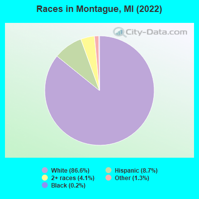
Races in Montague detailed stats: ancestries, foreign born residents, place of birth
According to our research of Michigan and other state lists, there were 27 registered sex offenders living in Montague, Michigan as of April 27, 2024.
The ratio of all residents to sex offenders in Montague is 92 to 1.
Type |
2009 |
2010 |
2011 |
2012 |
2013 |
2014 |
2015 |
2016 |
2017 |
2018 |
2019 |
2020 |
2021 |
2022 |
|---|---|---|---|---|---|---|---|---|---|---|---|---|---|---|
| Murders (per 100,000) | 0 (0.0) | 0 (0.0) | 0 (0.0) | 0 (0.0) | 0 (0.0) | 0 (0.0) | 0 (0.0) | 0 (0.0) | 0 (0.0) | 0 (0.0) | 1 (42.4) | 0 (0.0) | 0 (0.0) | 0 (0.0) |
| Rapes (per 100,000) | 0 (0.0) | 1 (42.4) | 0 (0.0) | 0 (0.0) | 1 (42.8) | 0 (0.0) | 2 (84.9) | 1 (42.3) | 0 (0.0) | 1 (42.6) | 0 (0.0) | 0 (0.0) | 1 (42.3) | 2 (82.1) |
| Robberies (per 100,000) | 0 (0.0) | 0 (0.0) | 0 (0.0) | 0 (0.0) | 0 (0.0) | 0 (0.0) | 0 (0.0) | 0 (0.0) | 0 (0.0) | 0 (0.0) | 0 (0.0) | 0 (0.0) | 0 (0.0) | 0 (0.0) |
| Assaults (per 100,000) | 1 (43.8) | 0 (0.0) | 1 (42.4) | 2 (85.1) | 1 (42.8) | 4 (169.5) | 0 (0.0) | 2 (84.7) | 3 (127.2) | 1 (42.6) | 2 (84.8) | 2 (84.7) | 0 (0.0) | 1 (41.0) |
| Burglaries (per 100,000) | 9 (394.4) | 7 (296.5) | 3 (127.2) | 8 (340.4) | 8 (342.2) | 1 (42.4) | 5 (212.2) | 3 (127.0) | 3 (127.2) | 1 (42.6) | 2 (84.8) | 1 (42.4) | 1 (42.3) | 0 (0.0) |
| Thefts (per 100,000) | 34 (1,490) | 34 (1,440) | 42 (1,780) | 69 (2,936) | 41 (1,754) | 44 (1,864) | 25 (1,061) | 25 (1,058) | 30 (1,272) | 26 (1,106) | 28 (1,187) | 14 (593.0) | 28 (1,183) | 25 (1,026) |
| Auto thefts (per 100,000) | 0 (0.0) | 0 (0.0) | 1 (42.4) | 0 (0.0) | 1 (42.8) | 1 (42.4) | 1 (42.4) | 0 (0.0) | 1 (42.4) | 0 (0.0) | 3 (127.2) | 2 (84.7) | 0 (0.0) | 0 (0.0) |
| Arson (per 100,000) | 0 (0.0) | 0 (0.0) | 2 (84.8) | 1 (42.6) | 0 (0.0) | 0 (0.0) | 0 (0.0) | 0 (0.0) | 0 (0.0) | 0 (0.0) | 0 (0.0) | 0 (0.0) | 0 (0.0) | 0 (0.0) |
| City-Data.com crime index | 96.0 | 112.2 | 92.0 | 158.3 | 140.3 | 114.8 | 128.6 | 102.0 | 88.6 | 89.8 | 165.3 | 50.4 | 84.1 | 114.9 |
The City-Data.com crime index weighs serious crimes and violent crimes more heavily. Higher means more crime, U.S. average is 246.1. It adjusts for the number of visitors and daily workers commuting into cities.
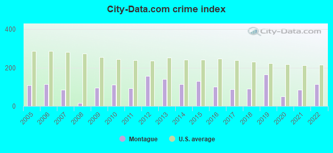
Crime rate in Montague detailed stats: murders, rapes, robberies, assaults, burglaries, thefts, arson
Full-time law enforcement employees in 2021, including police officers: 5 (5 officers - 5 male; 0 female).
| Officers per 1,000 residents here: | 2.11 |
| Michigan average: | 1.86 |
 Recent articles from our blog. Our writers, many of them Ph.D. graduates or candidates, create easy-to-read articles on a wide variety of topics.

 | Whitehall relocation-what are the best options? (9 replies) |
| Investment Property in South Haven? (18 replies) |
| Your favorite rural areas... (17 replies) |
| Top city's in MI (36 replies) |
| Getaway to Michigan, Help? (8 replies) |
| 4 Day Trip to Western MI (11 replies) |
Latest news from Montague, MI collected exclusively by city-data.com from local newspapers, TV, and radio stations
Ancestries: German (26.6%), American (11.9%), English (6.5%), Irish (4.6%), Norwegian (4.3%), Dutch (4.1%).
Current Local Time: EST time zone
Elevation: 192 feet
Land area: 2.66 square miles.
Population density: 907 people per square mile (low).
16 residents are foreign born
| This city: | 0.6% |
| Michigan: | 6.9% |
Median real estate property taxes paid for housing units with mortgages in 2022: $3,062 (1.7%)
Median real estate property taxes paid for housing units with no mortgage in 2022: $2,891 (1.4%)
Nearest city with pop. 50,000+: Grand Rapids, MI  (47.4 miles , pop. 197,800).
Nearest city with pop. 200,000+: Milwaukee, WI (84.1 miles , pop. 596,974).
Nearest city with pop. 1,000,000+: Chicago, IL (127.9 miles , pop. 2,896,016).
Nearest cities:
), ), ), Latitude: 43.42 N, Longitude: 86.36 W
Area code commonly used in this area: 231
Single-family new house construction building permits:
- 2022: 13 buildings, average cost: $286,800
- 2021: 6 buildings, average cost: $245,300
- 2020: 4 buildings, average cost: $55,800
- 2019: 14 buildings, average cost: $278,000
- 2018: 9 buildings, average cost: $163,700
- 2017: 6 buildings, average cost: $438,000
- 2016: 1 building, cost: $125,000
- 2015: 4 buildings, average cost: $148,500
- 2014: 2 buildings, average cost: $150,000
- 2013: 1 building, cost: $135,100
- 2012: 2 buildings, average cost: $383,300
- 2009: 1 building, cost: $86,800
- 2008: 4 buildings, average cost: $118,400
- 2007: 10 buildings, average cost: $144,400
- 2006: 13 buildings, average cost: $181,600
| Here: | 4.1% |
| Michigan: | 3.5% |
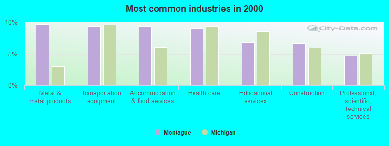
- Metal & metal products (9.7%)
- Transportation equipment (9.4%)
- Accommodation & food services (9.4%)
- Health care (9.1%)
- Educational services (6.9%)
- Construction (6.7%)
- Professional, scientific, technical services (4.7%)
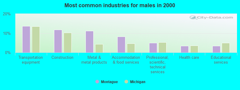
- Transportation equipment (13.6%)
- Construction (11.8%)
- Metal & metal products (11.1%)
- Accommodation & food services (8.1%)
- Professional, scientific, technical services (5.0%)
- Health care (3.5%)
- Educational services (3.5%)
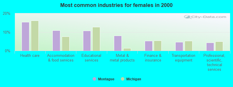
- Health care (15.3%)
- Accommodation & food services (10.8%)
- Educational services (10.6%)
- Metal & metal products (8.0%)
- Finance & insurance (5.2%)
- Transportation equipment (4.7%)
- Professional, scientific, technical services (4.3%)
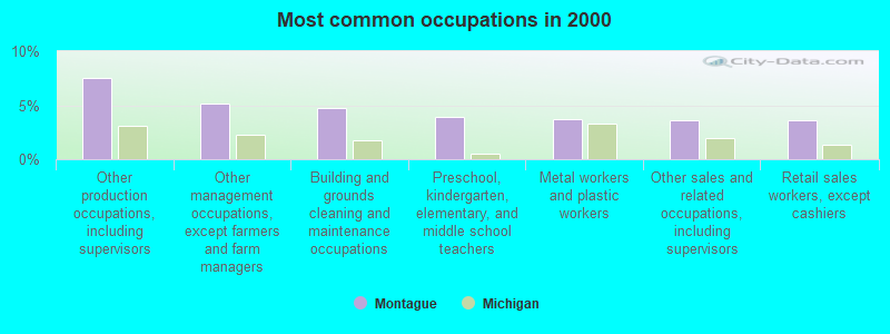
- Other production occupations, including supervisors (7.6%)
- Other management occupations, except farmers and farm managers (5.2%)
- Building and grounds cleaning and maintenance occupations (4.7%)
- Preschool, kindergarten, elementary, and middle school teachers (3.9%)
- Metal workers and plastic workers (3.7%)
- Other sales and related occupations, including supervisors (3.6%)
- Retail sales workers, except cashiers (3.6%)
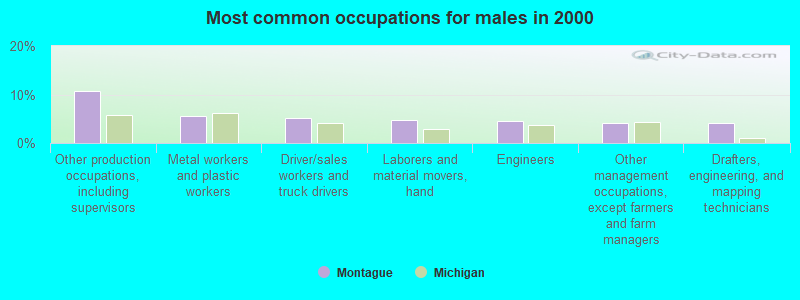
- Other production occupations, including supervisors (10.8%)
- Metal workers and plastic workers (5.5%)
- Driver/sales workers and truck drivers (5.1%)
- Laborers and material movers, hand (4.7%)
- Engineers (4.5%)
- Other management occupations, except farmers and farm managers (4.2%)
- Drafters, engineering, and mapping technicians (4.2%)
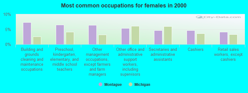
- Building and grounds cleaning and maintenance occupations (7.3%)
- Preschool, kindergarten, elementary, and middle school teachers (6.5%)
- Other management occupations, except farmers and farm managers (6.3%)
- Other office and administrative support workers, including supervisors (5.4%)
- Secretaries and administrative assistants (4.7%)
- Cashiers (4.7%)
- Retail sales workers, except cashiers (4.1%)
Average climate in Montague, Michigan
Based on data reported by over 4,000 weather stations


|
|


Tornado activity:
Montague-area historical tornado activity is below Michigan state average. It is 49% smaller than the overall U.S. average.
On 4/11/1965, a category F4 (max. wind speeds 207-260 mph) tornado 35.3 miles away from the Montague city center killed 5 people and injured 142 people and caused between $500,000 and $5,000,000 in damages.
On 4/3/1956, a category F5 (max. wind speeds 261-318 mph) tornado 52.1 miles away from the city center killed 18 people and injured 340 people and caused between $50,000 and $500,000 in damages.
Earthquake activity:
Montague-area historical earthquake activity is significantly above Michigan state average. It is 25% smaller than the overall U.S. average.On 5/2/2015 at 16:23:07, a magnitude 4.2 (4.2 MW, Depth: 2.8 mi, Class: Light, Intensity: IV - V) earthquake occurred 94.4 miles away from the city center
On 4/18/2008 at 09:36:59, a magnitude 5.4 (5.1 MB, 4.8 MS, 5.4 MW, 5.2 MW, Class: Moderate, Intensity: VI - VII) earthquake occurred 352.4 miles away from Montague center
On 1/31/1986 at 16:46:43, a magnitude 5.0 (5.0 MB) earthquake occurred 293.3 miles away from the city center
On 9/25/1998 at 19:52:52, a magnitude 5.2 (4.8 MB, 4.3 MS, 5.2 LG, 4.5 MW, Depth: 3.1 mi) earthquake occurred 332.2 miles away from the city center
On 6/10/1987 at 23:48:54, a magnitude 5.1 (4.9 MB, 4.4 MS, 4.6 MS, 5.1 LG) earthquake occurred 327.5 miles away from the city center
On 7/12/1986 at 08:19:37, a magnitude 4.5 (4.5 MB) earthquake occurred 223.9 miles away from the city center
Magnitude types: regional Lg-wave magnitude (LG), body-wave magnitude (MB), surface-wave magnitude (MS), moment magnitude (MW)
Natural disasters:
The number of natural disasters in Muskegon County (12) is smaller than the US average (15).Major Disasters (Presidential) Declared: 7
Emergencies Declared: 4
Causes of natural disasters: Floods: 6, Storms: 6, Tornadoes: 2, Winds: 2, Winter Storms: 2, Blizzard: 1, Hurricane: 1, Snowstorm: 1, Other: 1 (Note: some incidents may be assigned to more than one category).

Hospitals and medical centers near Montague:
- HEARTLAND HEALTH CARE CENTER-WHITEHALL (Nursing Home, about 2 miles away; WHITEHALL, MI)
- HILLCREST NURSING CENTRE (Nursing Home, about 12 miles away; MUSKEGON, MI)
- HILLCREST NURSING AND REHABILITATION COMMUNITY (Nursing Home, about 12 miles away; NORTH MUSKEGON, MI)
- HACKLEY LAKESHORE HOSPITAL (Hospital, about 14 miles away; SHELBY, MI)
- MERCY HEALTH PARTNERS, LAKESHORE CAMPUS Critical Access Hospitals (about 14 miles away; SHELBY, MI)
- HACKLEY VISITING NURSE SERVICES AND HOSPICE (Hospital, about 14 miles away; MUSKEGON, MI)
- HARBOR HOSPICE (Hospital, about 14 miles away; MUSKEGON, MI)
Colleges/universities with over 2000 students nearest to Montague:
- Muskegon Community College (about 15 miles; Muskegon, MI; Full-time enrollment: 3,310)
- Baker College of Muskegon (about 15 miles; Muskegon, MI; FT enrollment: 3,293)
- Grand Valley State University (about 40 miles; Allendale, MI; FT enrollment: 21,982)
- Hope College (about 46 miles; Holland, MI; FT enrollment: 3,535)
- Grand Rapids Community College (about 47 miles; Grand Rapids, MI; FT enrollment: 11,296)
- Ferris State University (about 48 miles; Big Rapids, MI; FT enrollment: 11,238)
- Cornerstone University (about 50 miles; Grand Rapids, MI; FT enrollment: 2,573)
Public high school in Montague:
- MONTAGUE HIGH SCHOOL (Students: 479, Location: 4900 STANTON BLVD, Grades: 9-12)
Public elementary/middle schools in Montague:
- OEHRLI ELEMENTARY SCHOOL (Students: 633, Location: 4859 KNUDSEN ST, Grades: 1-5)
- NELLIE B. CHISHOLM MIDDLE SCHOOL (Students: 334, Location: 4700 STANTON BLVD, Grades: 6-8)
User-submitted facts and corrections:
- The Montague Weathervane was moved from the waterfront of whitelake to the corner of Dowling and Water street, in 2004
Points of interest:
Notable locations in Montague: Montague Marina (A), Trailway Campground (B), Montague Fire Department (C), Montague Police Department (D), Montague City Public Library (E), Montague City Hall (F), Montague City Museum (G). Display/hide their locations on the map
Churches in Montague include: Whitelake Church (A), Saint James Catholic Church (B), Ferry Memorial Reformed Church (C), Montague United Methodist Church (D), Saint James Lutheran Church (E). Display/hide their locations on the map
Cemeteries: Oak Grove Cemetery (1), Mount Calvary Cemetery (2), Oakwood Cemetery (3). Display/hide their locations on the map
Parks in Montague include: Ellenwood Park (1), Cullen Field (2), Maple Grove Park (3). Display/hide their locations on the map
Birthplace of: Ira Flagstead - Baseball player.
Drinking water stations with addresses in Montague and their reported violations in the past:
OLD CHANNEL INN (Population served: 150, Groundwater):Past monitoring violations:NORTHERN LIGHTS FAMILY PRACTICE (Population served: 40, Groundwater):
- One routine major monitoring violation
- One regular monitoring violation
Past health violations:PIGEON HILL RESORT (Population served: 38, Groundwater):Past monitoring violations:
- MCL, Average - Between JAN-2014 and MAR-2014, Contaminant: Nitrate. Follow-up actions: St Public Notif issued (JAN-29-2014), St Tech Assistance Visit (JAN-29-2014), St Violation/Reminder Notice (JAN-29-2014)
- 5 routine major monitoring violations
- 3 regular monitoring violations
Past monitoring violations:WEESIES BROS PKG HOUSE-#1,2,4 (Population served: 30, Groundwater):
- 2 routine major monitoring violations
- 2 regular monitoring violations
Past monitoring violations:WHITE RIVER CAMPGROUND (Population served: 25, Groundwater):
- One routine major monitoring violation
- One regular monitoring violation
Past monitoring violations:
- One regular monitoring violation
Drinking water stations with addresses in Montague that have no violations reported:
- VILLA VENAFRO (Population served: 150, Primary Water Source Type: Groundwater)
- OUR LADY OF ASSUMPTION CHURCH (Population served: 100, Primary Water Source Type: Groundwater)
- GREENLAWN MOBILE HOME COURT (Population served: 100, Primary Water Source Type: Groundwater)
- JOHNSON'S TRAILER RESORT (Population served: 52, Primary Water Source Type: Groundwater)
- HICKORY KNOLL GOLF COURSE INC (Population served: 50, Primary Water Source Type: Groundwater)
- WHITE RIVER BEACH ASSOCIATION (Population served: 40, Primary Water Source Type: Groundwater)
- WHITE LAKE VFW POST #3256 (Population served: 25, Primary Water Source Type: Groundwater)
- SUNRISE CAMPGROUND (Population served: 25, Primary Water Source Type: Groundwater)
- OLD CHANNEL TR GOLF-EAST PRO (Population served: 25, Primary Water Source Type: Groundwater)
- OLD CHANNEL TRAIL GOLF COURSE (Population served: 25, Primary Water Source Type: Groundwater)
| This city: | 2.4 people |
| Michigan: | 2.5 people |
| This city: | 63.9% |
| Whole state: | 66.0% |
| This city: | 7.0% |
| Whole state: | 6.4% |
Likely homosexual households (counted as self-reported same-sex unmarried-partner households)
- Lesbian couples: 0.6% of all households
- Gay men: 0.3% of all households
Banks with branches in Montague (2011 data):
- Comerica Bank: Montague Branch at 4555 Dowling Street, branch established on 1956/02/14. Info updated 2011/07/29: Bank assets: $60,970.5 mil, Deposits: $48,300.9 mil, headquarters in Dallas, TX, positive income, Commercial Lending Specialization, 497 total offices, Holding Company: Comerica Incorporated
For population 15 years and over in Montague:
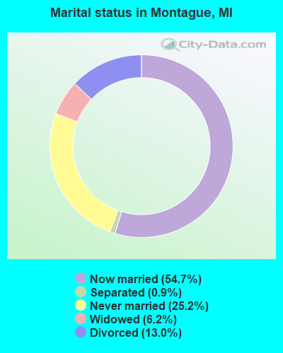
- Never married: 25.2%
- Now married: 54.7%
- Separated: 0.9%
- Widowed: 6.2%
- Divorced: 13.0%
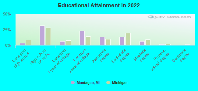
For population 25 years and over in Montague:
- High school or higher: 96.5%
- Bachelor's degree or higher: 19.6%
- Graduate or professional degree: 7.3%
- Unemployed: 5.6%
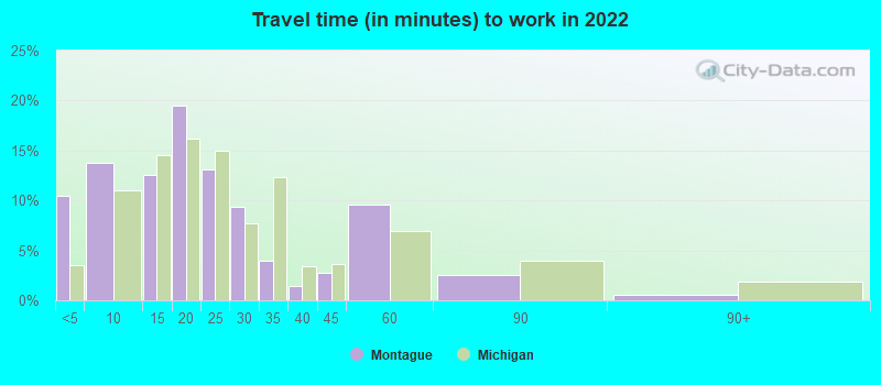
- Mean travel time to work (commute): 18.4 minutes
| Here: | 7.9 |
| Michigan average: | 11.0 |
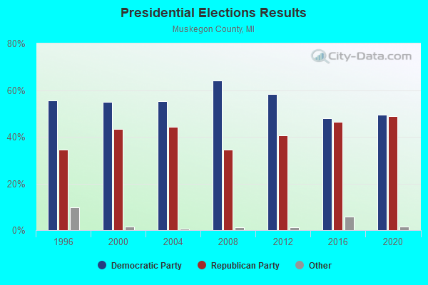
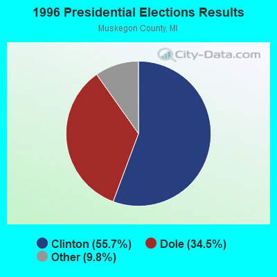
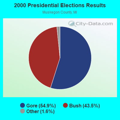
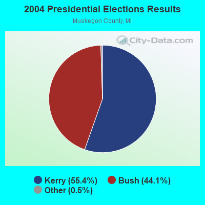
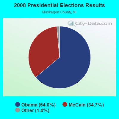
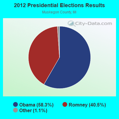
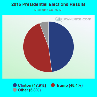
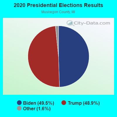
Graphs represent county-level data. Detailed 2008 Election Results
Religion statistics for Montague, MI (based on Muskegon County data)
| Religion | Adherents | Congregations |
|---|---|---|
| Evangelical Protestant | 18,063 | 105 |
| Mainline Protestant | 14,051 | 49 |
| Catholic | 13,687 | 11 |
| Black Protestant | 3,314 | 11 |
| Other | 2,464 | 10 |
| Orthodox | 350 | 1 |
| None | 120,259 | - |
Food Environment Statistics:
| Muskegon County: | 1.38 / 10,000 pop. |
| Michigan: | 2.34 / 10,000 pop. |
| Muskegon County: | 0.29 / 10,000 pop. |
| State: | 0.18 / 10,000 pop. |
| Muskegon County: | 1.95 / 10,000 pop. |
| Michigan: | 1.52 / 10,000 pop. |
| Muskegon County: | 3.10 / 10,000 pop. |
| Michigan: | 2.99 / 10,000 pop. |
| Muskegon County: | 6.72 / 10,000 pop. |
| Michigan: | 6.80 / 10,000 pop. |
| This county: | 10.8% |
| State: | 9.7% |
| Muskegon County: | 30.5% |
| Michigan: | 29.7% |
| This county: | 13.2% |
| Michigan: | 13.4% |
Health and Nutrition:
| This city: | 51.7% |
| Michigan: | 50.3% |
| This city: | 50.3% |
| Michigan: | 47.9% |
| Montague: | 28.6 |
| State: | 28.7 |
| Montague: | 19.0% |
| State: | 20.6% |
| This city: | 8.0% |
| Michigan: | 10.4% |
| Montague: | 6.8 |
| Michigan: | 6.8 |
| Here: | 36.5% |
| Michigan: | 34.1% |
| This city: | 58.1% |
| State: | 57.0% |
| Montague: | 78.9% |
| Michigan: | 79.6% |
More about Health and Nutrition of Montague, MI Residents
| Local government employment and payroll (March 2022) | |||||
| Function | Full-time employees | Monthly full-time payroll | Average yearly full-time wage | Part-time employees | Monthly part-time payroll |
|---|---|---|---|---|---|
| Police Protection - Officers | 5 | $29,513 | $70,831 | 2 | $2,502 |
| Other Government Administration | 3 | $17,805 | $71,220 | 0 | $0 |
| Streets and Highways | 2 | $11,925 | $71,550 | 0 | $0 |
| Parks and Recreation | 1 | $6,088 | $73,056 | 0 | $0 |
| Financial Administration | 1 | $6,703 | $80,436 | 0 | $0 |
| Other and Unallocable | 1 | $4,550 | $54,600 | 0 | $0 |
| Sewerage | 1 | $6,005 | $72,060 | 0 | $0 |
| Water Supply | 1 | $7,771 | $93,252 | 0 | $0 |
| Police - Other | 0 | $0 | 3 | $3,183 | |
| Totals for Government | 15 | $90,360 | $72,288 | 5 | $5,685 |
Montague government finances - Expenditure in 2017 (per resident):
- Current Operations - Sewerage: $802,000 ($332.37)
Police Protection: $704,000 ($291.75)
General - Other: $555,000 ($230.00)
Regular Highways: $313,000 ($129.71)
Central Staff Services: $262,000 ($108.58)
Financial Administration: $169,000 ($70.04)
General Public Buildings: $127,000 ($52.63)
Parks and Recreation: $78,000 ($32.32)
Protective Inspection and Regulation - Other: $58,000 ($24.04)
Libraries: $4,000 ($1.66)
- General - Interest on Debt: $60,000 ($24.87)
- Intergovernmental to Local - Other - Sewerage: $216,000 ($89.52)
Other - Police Protection: $39,000 ($16.16)
- Other Capital Outlay - Regular Highways: $146,000 ($60.51)
Housing and Community Development: $14,000 ($5.80)
General - Other: $6,000 ($2.49)
Parks and Recreation: $4,000 ($1.66)
- Total Salaries and Wages: $1,183,000 ($490.26)
- Water Utilities - Interest on Debt: $11,000 ($4.56)
Montague government finances - Revenue in 2017 (per resident):
- Charges - Sewerage: $469,000 ($194.36)
Parks and Recreation: $170,000 ($70.45)
Other: $29,000 ($12.02)
- Local Intergovernmental - Other: $159,000 ($65.89)
- Miscellaneous - Rents: $83,000 ($34.40)
General Revenue - Other: $56,000 ($23.21)
Interest Earnings: $51,000 ($21.14)
Donations From Private Sources: $11,000 ($4.56)
Sale of Property: $6,000 ($2.49)
Fines and Forfeits: $5,000 ($2.07)
- Revenue - Water Utilities: $607,000 ($251.55)
- State Intergovernmental - Other: $305,000 ($126.40)
Highways: $304,000 ($125.98)
General Local Government Support: $215,000 ($89.10)
- Tax - Property: $1,448,000 ($600.08)
Other License: $71,000 ($29.42)
Montague government finances - Debt in 2017 (per resident):
- Long Term Debt - Beginning Outstanding - Unspecified Public Purpose: $1,660,000 ($687.94)
Outstanding Unspecified Public Purpose: $1,491,000 ($617.90)
Retired Unspecified Public Purpose: $170,000 ($70.45)
Montague government finances - Cash and Securities in 2017 (per resident):
- Other Funds - Cash and Securities: $2,802,000 ($1161.21)
Businesses in Montague, MI
- YMCA: 1
Strongest AM radio stations in Montague:
- WUBR (1490 AM; 1 kW; WHITEHALL, MI; Owner: UNITY BROADCASTING, INC.)
- WMHG (1600 AM; 5 kW; MUSKEGON, MI)
- WTMJ (620 AM; 50 kW; MILWAUKEE, WI; Owner: JOURNAL BROADCAST CORPORATION)
- WMUS (1090 AM; daytime; 1 kW; MUSKEGON, MI; Owner: CLEAR CHANNEL BROADCASTING LICENSES, INC.)
- WTCM (580 AM; 35 kW; TRAVERSE CITY, MI; Owner: WTCM RADIO, INC.)
- WOOD (1300 AM; 20 kW; GRAND RAPIDS, MI; Owner: CLEAR CHANNEL BROADCASTING LICENSES, INC.)
- WLDR (1210 AM; daytime; 50 kW; KINGSLEY, MI; Owner: FORT BEND BROADCASTING COMPANY)
- WISN (1130 AM; 50 kW; MILWAUKEE, WI; Owner: CAPSTAR TX LIMITED PARTNERSHIP)
- WGN (720 AM; 50 kW; CHICAGO, IL; Owner: WGN CONTINENTAL BROADCASTING CO.)
- WSCR (670 AM; 50 kW; CHICAGO, IL; Owner: INFINITY BROADCASTING OPERATIONS, INC.)
- WBBM (780 AM; 50 kW; CHICAGO, IL; Owner: INFINITY BROADCASTING OPERATIONS, INC.)
- WOAP (1080 AM; 50 kW; OWOSSO, MI)
- WPNW (1260 AM; 10 kW; ZEELAND, MI; Owner: LANSER BROADCASTING CORPORATION)
Strongest FM radio stations in Montague:
- WEFG-FM (97.5 FM; WHITEHALL, MI; Owner: UNITY BROADCASTING, INC.)
- WGVS-FM (95.3 FM; WHITEHALL, MI; Owner: GRAND VALLEY STATE UNIVERSITY)
- WMRR (101.7 FM; MUSKEGON HEIGHTS, MI; Owner: CLEAR CHANNEL BROADCASTING LICENSES, INC.)
- WCXT (105.3 FM; HART, MI; Owner: WATERS BROADCASTING CORPORATION)
- WSHZ (107.9 FM; MUSKEGON, MI; Owner: CLEAR CHANNEL BROADCASTING LICENSES, INC.)
- WLCS (98.3 FM; NORTH MUSKEGON, MI; Owner: UNITY BROADCASTING, INC.)
- W215AS (90.9 FM; MUSKEGON, MI; Owner: PENSACOLA CHRISTIAN COLLEGE, INC.)
- WBLV (90.3 FM; TWIN LAKE, MI; Owner: BLUE LAKE FINE ARTS CAMP, INC.)
- WSNX-FM (104.5 FM; MUSKEGON, MI; Owner: CLEAR CHANNEL BROADCASTING LICENSES, INC.)
- WMUS-FM (106.9 FM; MUSKEGON, MI; Owner: CLEAR CHANNEL BROADCASTING LICENSES, INC.)
- WWKR (94.1 FM; PENTWATER, MI; Owner: SYNERGY MEDIA, INC.)
- WSHN-FM (100.1 FM; HOLTON, MI; Owner: NOORDYK BROADCASTING, INC.)
- WMOM (102.7 FM; PENTWATER, MI; Owner: BAY VIEW BROADCASTING, INC)
TV broadcast stations around Montague:
- WZZM-TV (Channel 13; GRAND RAPIDS, MI; Owner: COMBINED COMMUNICATIONS CORP. OF OKLAHOMA, INC.)
- W42CB (Channel 42; HESPERIA, MI; Owner: TRIBUNE TELEVISION HOLDINGS, INC.)
- WOMS-CA (Channel 29; MUSKEGON, MI; Owner: WOOD LICENSE COMPANY, LLC)
- W34BZ (Channel 34; LUDINGTON, MI; Owner: MS COMMUNICATIONS, LLC)
- W48BY (Channel 48; LUDINGTON, MI; Owner: MS COMMUNICATIONS, LLC)
- W67DN (Channel 67; HOUGHTON LAKE, MI; Owner: MS COMMUNICATIONS, LLC)
- W53CC (Channel 53; LUDINGTON, MI; Owner: MS COMMUNICATIONS, LLC)
- WTLJ (Channel 54; MUSKEGON, MI; Owner: TCT OF MICHIGAN, INC.)
- WGVU-TV (Channel 35; GRAND RAPIDS, MI; Owner: GRAND VALLEY STATE UNIVERSITY)
- WMKG-LP (Channel 38; NORTON SHORES, MI; Owner: KELLEY ENTERPRISES)
Montague fatal accident list:
Jul 17, 1993 02:24 AM, Old Channe, Vehicles: 1, Persons: 2, Fatalities: 1, Drunk persons involved: 1
Feb 26, 1978 01:05 PM, Vehicles: 2, Persons: 3, Fatalities: 1
- National Bridge Inventory (NBI) Statistics
- 16Number of bridges
- 118ft / 36.2mTotal length
- 68,602Total average daily traffic
- 3,627Total average daily truck traffic
- New bridges - historical statistics
- 1Before 1900
- 11900-1909
- 21920-1929
- 11940-1949
- 21950-1959
- 31960-1969
- 21970-1979
- 11990-1999
- 22000-2009
- 12010-2019
FCC Registered Cell Phone Towers:
1 (See the full list of FCC Registered Cell Phone Towers in Montague)FCC Registered Antenna Towers:
39 (See the full list of FCC Registered Antenna Towers)FCC Registered Broadcast Land Mobile Towers:
7- Cor Ferry St And Dowling (Lat: 43.418333 Lon: -86.360056), Call Sign: KQL867, Licensee ID: L00074837,
Assigned Frequencies: 154.190 MHz, Grant Date: 05/08/1997, Expiration Date: 07/21/2002, Cancellation Date: 11/24/2002, Registrant: City Of Montague, 8660 Water St, Montague, MI 49437, Phone: (616) 893-3311
- N Of Fruitvale Rd W Of Us Hwy 31 (Lat: 43.435278 Lon: -86.340333), Call Sign: WNVY875, Licensee ID: L00013266,
Assigned Frequencies: 451.025 MHz, Grant Date: 04/04/1996, Expiration Date: 04/04/2001, Cancellation Date: 01/24/2001, Registrant: Michigan Consolidated Gas Company Dba Michcon, 500 Griswold Street, Detroit, MI 48226, Phone: (616) 459-6810
- Old Channel Trl & W Whitbeck Rd (Lat: 43.388889 Lon: -86.386167), Call Sign: KBI379,
Assigned Frequencies: 158.280 MHz, Grant Date: 03/01/2001, Expiration Date: 03/11/2011, Cancellation Date: 05/14/2011, Registrant: Business Radio Licensing, 26941 Cabot Rd #134, Laguna Hills, CA 92653, Phone: (949) 348-8510, Fax: (949) 348-8514
- 4900 Stanton Blvd. (Lat: 43.423056 Lon: -86.363167), Type: Mast, Structure height: 16.7 m, Overall height: 18.3 m, Call Sign: WQNT843,
Assigned Frequencies: 72.1800 MHz, Grant Date: 05/23/2011, Expiration Date: 05/23/2021, Cancellation Date: 07/24/2021, Certifier: Tom Cederquist, Registrant: Primex Wireless, Inc., 965 Wells Street, Lake Geneva, WI 53147, Phone: (800) 537-0464
- 5353 Wilcox St (Lat: 43.409833 Lon: -86.373472), Call Sign: WRDB261,
Assigned Frequencies: 462.237 MHz, 462.262 MHz, 462.287 MHz, 462.312 MHz, 462.337 MHz, 462.362 MHz, 462.187 MHz, 462.412 MHz, 462.437 MHz, 462.462 MHz, 462.487 MHz, Grant Date: 03/18/2019, Expiration Date: 03/18/2029, Certifier: Bill Sikkenga, Registrant: Federal Licensing Inc, 1588 Fairfield Road, Gettysburg, PA 17325, Phone: (717) 334-9262, Fax: (717) 334-6440, Email:
- WILCOX ST., 5085 Wilcox St (Lat: 43.410083 Lon: -86.369694), Type: Ltower, Structure height: 91.4 m, Overall height: 93.9 m, Call Sign: WRMA692,
Assigned Frequencies: 857.837 MHz, 859.887 MHz, Grant Date: 03/15/2021, Expiration Date: 03/15/2031, Certifier: Michael Payionk, Registrant: Dte Energy Company, 1 Energy Plz, Detroit, MI 48226, Phone: (313) 235-9713, Fax: (717) 637-8300, Email:
- 4900 Stanton Blvd. (Lat: 43.423056 Lon: -86.363167), Type: Mast, Structure height: 16.7 m, Overall height: 18.3 m, Call Sign: WROR383,
Assigned Frequencies: 72.1800 MHz, Grant Date: 11/23/2021, Expiration Date: 11/23/2031, Certifier: Tom Cederquist, Registrant: Primex Wireless, Inc., 965 S Wells St, Lake Geneva, WI 53147, Phone: (262) 729-4858, Email:
FCC Registered Microwave Towers:
3- Lasley Street Tower, Lasley Street (Lat: 43.421611 Lon: -86.359528), Type: Tank, Structure height: 45.7 m, Overall height: 48.7 m, Call Sign: WPUT995,
Assigned Frequencies: 932.256 MHz, 941.256 MHz, Grant Date: 03/03/2022, Expiration Date: 05/02/2032, Certifier: Tom Kroll, Registrant: J & K Communications, Inc., 222 South Tower View Dr., Columbia City, IN 46725, Phone: (219) 244-7975, Fax: (219) 244-3253, Email:
- Montague, Lat: 43.421000 Lon: -86.359500, Call Sign: WQAS936, Licensee ID: L00120221,
Assigned Frequencies: 956.281 MHz, Grant Date: 05/30/2014, Expiration Date: 08/02/2024, Certifier: Thomas Kroll, Registrant: City Of Montague
- 6903 WILCOX, 5085 Wilcox St (Lat: 43.410083 Lon: -86.369694), Type: Ltower, Structure height: 91.4 m, Overall height: 93.9 m, Call Sign: WRFR299,
Assigned Frequencies: 5945.20 MHz, 6004.50 MHz, Grant Date: 04/15/2020, Expiration Date: 04/15/2030, Certifier: Mark E Sandberg, Registrant: State Of Michigan, 7150 Harris Drive, Dimondale, MI 48821, Phone: (517) 333-5050, Email:
FCC Registered Maritime Coast & Aviation Ground Towers:
3- 4650 Goodrich St (Lat: 43.401944 Lon: -86.358111), Type: Building, Overall height: 9 m, Call Sign: WHD605,
Assigned Frequencies: 156.425 MHz, 156.450 MHz, 156.500 MHz, 156.800 MHz, Grant Date: 09/22/1994, Expiration Date: 09/22/1999, Cancellation Date: 05/06/2001, Registrant: Wesley Marine Service Company, 4650 Goodrich St, Montague, MI 49437
- 4525 Dowling St (Lat: 43.375000 Lon: -86.426444), Type: Building, Overall height: 8 m, Call Sign: WHX502, Licensee ID: L00005856,
Assigned Frequencies: 156.450 MHz, 156.800 MHz, Grant Date: 02/25/1997, Expiration Date: 04/23/2002, Cancellation Date: 07/28/2002, Registrant: Ellenwood Landing Condominium Association, 4525 Dowling St, Montague, MI 49437
- 8560 Ellenwood Drive (Lat: 43.375000 Lon: -86.426444), Type: Bant, Structure height: 8.2 m, Call Sign: WPWN973, Licensee ID: L00005856,
Assigned Frequencies: 156.450 MHz, 156.800 MHz, Grant Date: 12/30/2002, Expiration Date: 12/30/2012, Cancellation Date: 03/02/2013, Certifier: Martin L Leemaster, Registrant: Ellenwood Landing Condominium Association
FCC Registered Amateur Radio Licenses:
41 (See the full list of FCC Registered Amateur Radio Licenses in Montague)FAA Registered Aircraft:
11 (See the full list of FAA Registered Aircraft in Montague)| Home Mortgage Disclosure Act Aggregated Statistics For Year 2009 (Based on 1 partial tract) | ||||||||||
| A) FHA, FSA/RHS & VA Home Purchase Loans | B) Conventional Home Purchase Loans | C) Refinancings | D) Home Improvement Loans | F) Non-occupant Loans on < 5 Family Dwellings (A B C & D) | ||||||
|---|---|---|---|---|---|---|---|---|---|---|
| Number | Average Value | Number | Average Value | Number | Average Value | Number | Average Value | Number | Average Value | |
| LOANS ORIGINATED | 3 | $88,870 | 3 | $112,813 | 16 | $133,939 | 1 | $29,830 | 4 | $152,278 |
| APPLICATIONS APPROVED, NOT ACCEPTED | 1 | $52,750 | 1 | $77,510 | 1 | $142,230 | 0 | $0 | 1 | $84,610 |
| APPLICATIONS DENIED | 0 | $0 | 1 | $54,990 | 6 | $209,055 | 1 | $64,120 | 2 | $379,525 |
| APPLICATIONS WITHDRAWN | 1 | $67,160 | 0 | $0 | 2 | $257,480 | 0 | $0 | 0 | $0 |
| FILES CLOSED FOR INCOMPLETENESS | 0 | $0 | 0 | $0 | 1 | $117,680 | 0 | $0 | 0 | $0 |
Detailed HMDA statistics for the following Tracts: 0038.00
| Private Mortgage Insurance Companies Aggregated Statistics For Year 2009 (Based on 1 partial tract) | ||
| B) Refinancings | ||
|---|---|---|
| Number | Average Value | |
| LOANS ORIGINATED | 0 | $0 |
| APPLICATIONS APPROVED, NOT ACCEPTED | 0 | $0 |
| APPLICATIONS DENIED | 0 | $0 |
| APPLICATIONS WITHDRAWN | 1 | $53,570 |
| FILES CLOSED FOR INCOMPLETENESS | 0 | $0 |
Detailed PMIC statistics for the following Tracts: 0038.00
2002 - 2018 National Fire Incident Reporting System (NFIRS) incidents
- Fire incident types reported to NFIRS in Montague, MI
- 15636.0%Outside Fires
- 14433.3%Structure Fires
- 7216.6%Mobile Property/Vehicle Fires
- 6114.1%Other
 According to the data from the years 2002 - 2018 the average number of fires per year is 25. The highest number of reported fires - 38 took place in 2005, and the least - 3 in 2012. The data has a dropping trend.
 When looking into fire subcategories, the most reports belonged to: Outside Fires (36.0%), and Structure Fires (33.3%).
| Most common first names in Montague, MI among deceased individuals | ||
| Name | Count | Lived (average) |
|---|---|---|
| Robert | 46 | 67.8 years |
| William | 35 | 76.8 years |
| John | 28 | 72.3 years |
| George | 26 | 71.3 years |
| Charles | 25 | 76.6 years |
| James | 23 | 69.4 years |
| Mary | 20 | 80.5 years |
| Fred | 19 | 79.0 years |
| Edward | 19 | 76.6 years |
| Harold | 19 | 72.6 years |
| Most common last names in Montague, MI among deceased individuals | ||
| Last name | Count | Lived (average) |
|---|---|---|
| Smith | 30 | 79.4 years |
| Johnson | 22 | 74.9 years |
| Ramthun | 15 | 81.0 years |
| Anderson | 14 | 74.7 years |
| Schultz | 14 | 74.4 years |
| Dahl | 13 | 83.2 years |
| Schmiedeknec | 13 | 87.2 years |
| Kroll | 13 | 83.5 years |
| Lipka | 11 | 84.8 years |
| Hill | 11 | 80.8 years |
- 95.1%Utility gas
- 2.9%Electricity
- 1.1%Bottled, tank, or LP gas
- 0.9%Wood
- 58.0%Utility gas
- 39.0%Electricity
- 3.0%Other fuel
Montague compared to Michigan state average:
- Unemployed percentage below state average.
- Black race population percentage significantly below state average.
- Foreign-born population percentage significantly below state average.
- Number of college students below state average.

|
|
Total of 15 patent applications in 2008-2024.