New Hartford, Connecticut
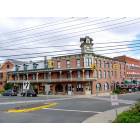
Submit your own pictures of this town and show them to the world
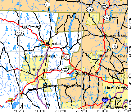
- OSM Map
- General Map
- Google Map
- MSN Map
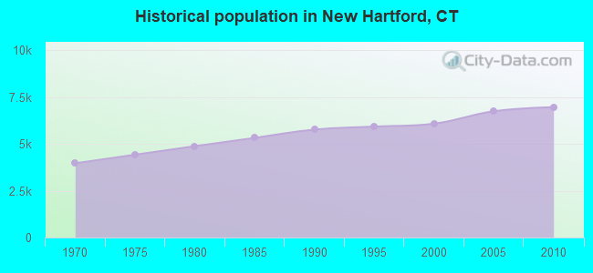
Population change since 2000: +14.5%
 |
| Males: 3,474 | |
| Females: 3,496 |
| Median resident age: | 44.1 years |
| Connecticut median age: | 39.2 years |
Zip codes: 06057.
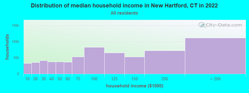
| New Hartford: | $113,655 |
| CT: | $88,429 |
Estimated per capita income in 2022: $54,563 (it was $30,429 in 2000)
New Hartford town income, earnings, and wages data
Estimated median house or condo value in 2022: $380,709 (it was $176,100 in 2000)
| New Hartford: | $380,709 |
| CT: | $347,200 |
Mean prices in 2022: all housing units: $429,743; detached houses: $455,293; townhouses or other attached units: $232,674; in 2-unit structures: $242,050; in 3-to-4-unit structures: $229,634; in 5-or-more-unit structures: $182,162; mobile homes: $243,504; occupied boats, rvs, vans, etc.: $127,144
Detailed information about poverty and poor residents in New Hartford, CT


- 6,68695.9%White alone
- 1241.8%Hispanic
- 791.1%Asian alone
- 570.8%Two or more races
- 180.3%Black alone
- 30.04%American Indian alone
- 30.04%Other race alone
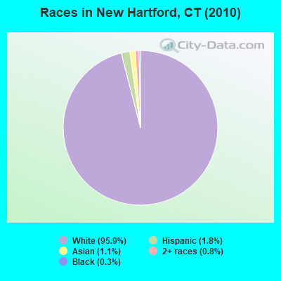
Races in New Hartford detailed stats: ancestries, foreign born residents, place of birth
According to our research of Connecticut and other state lists, there were 6 registered sex offenders living in New Hartford, Connecticut as of April 28, 2024.
The ratio of all residents to sex offenders in New Hartford is 1,162 to 1.
The ratio of registered sex offenders to all residents in this city is lower than the state average.
 Recent articles from our blog. Our writers, many of them Ph.D. graduates or candidates, create easy-to-read articles on a wide variety of topics.

 | 2024 Connecticut Town Tournament VI (Celebrating the 10-Year Anniversary & Dazzleman's Memorial) (746 replies) |
| Connecticut Weather Discussion 4 (1147 replies) |
| Connecticut TOWN TOURNAMENT V (2022) (831 replies) |
| New Hartford, best kept secret? (18 replies) |
| Connecticut’s Historic Character Lost (124 replies) |
| Connecticut Weather Discussion 3 (8061 replies) |
Latest news from New Hartford, CT collected exclusively by city-data.com from local newspapers, TV, and radio stations
New Hartford, CT City Guides:
Ancestries: English (21.9%), Italian (19.0%), Irish (17.3%), German (14.8%), Polish (14.7%), French (10.5%).
Current Local Time: EST time zone
Incorporated on 10/1738
Elevation: 450 feet
Land area: 37.0 square miles.
Population density: 188 people per square mile (very low).
264 residents are foreign born (1.9% Europe, 1.1% North America, 0.8% Asia, 0.5% Latin America).
| This town: | 4.3% |
| Connecticut: | 10.9% |
| New Hartford town: | 1.9% ($3,359) |
| Connecticut: | 1.8% ($2,961) |
Nearest city with pop. 50,000+: Bristol, CT  (12.4 miles , pop. 60,062).
Nearest city with pop. 200,000+: North Hempstead, NY (81.9 miles , pop. 222,611).
Nearest city with pop. 1,000,000+: Bronx, NY (82.9 miles , pop. 1,332,650).
Nearest cities:
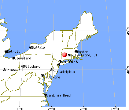
), ), )Latitude: 41.85 N, Longitude: 73.00 W
Area code commonly used in this area: 860

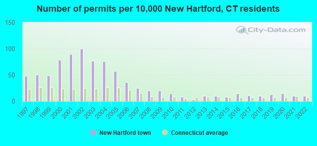
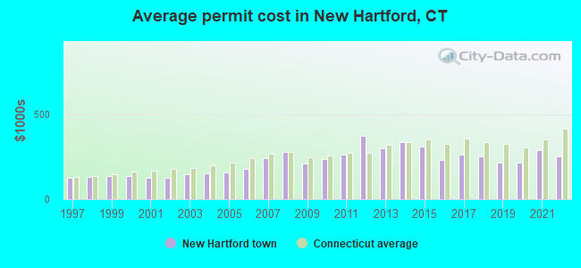
Single-family new house construction building permits:
- 2022: 6 buildings, average cost: $251,700
- 2021: 6 buildings, average cost: $289,000
- 2020: 9 buildings, average cost: $214,400
- 2019: 8 buildings, average cost: $214,400
- 2018: 6 buildings, average cost: $250,700
- 2017: 7 buildings, average cost: $262,000
- 2016: 9 buildings, average cost: $229,900
- 2015: 5 buildings, average cost: $309,000
- 2014: 6 buildings, average cost: $335,600
- 2013: 6 buildings, average cost: $299,900
- 2012: 2 buildings, average cost: $373,100
- 2011: 5 buildings, average cost: $260,500
- 2010: 9 buildings, average cost: $236,100
- 2009: 12 buildings, average cost: $211,100
- 2008: 12 buildings, average cost: $281,100
- 2007: 15 buildings, average cost: $239,800
- 2006: 22 buildings, average cost: $177,500
- 2005: 35 buildings, average cost: $159,900
- 2004: 46 buildings, average cost: $154,100
- 2003: 47 buildings, average cost: $147,400
- 2002: 61 buildings, average cost: $125,800
- 2001: 55 buildings, average cost: $126,100
- 2000: 48 buildings, average cost: $137,000
- 1999: 30 buildings, average cost: $135,500
- 1998: 31 buildings, average cost: $133,300
- 1997: 29 buildings, average cost: $126,900
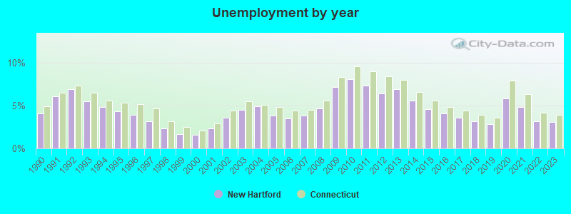
| Here: | 3.1% |
| Connecticut: | 3.9% |
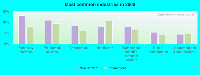
- Finance & insurance (13.1%)
- Educational services (10.9%)
- Construction (8.4%)
- Health care (7.9%)
- Professional, scientific, technical services (7.9%)
- Public administration (5.4%)
- Accommodation & food services (4.5%)
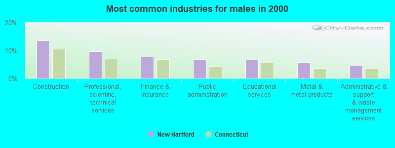
- Construction (13.7%)
- Professional, scientific, technical services (9.7%)
- Finance & insurance (7.9%)
- Public administration (6.8%)
- Educational services (6.7%)
- Metal & metal products (5.9%)
- Administrative & support & waste management services (4.7%)
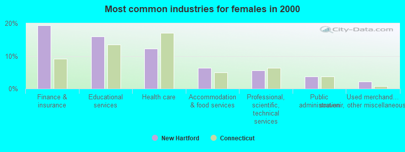
- Finance & insurance (19.4%)
- Educational services (15.9%)
- Health care (12.2%)
- Accommodation & food services (6.3%)
- Professional, scientific, technical services (5.6%)
- Public administration (3.7%)
- Used merchandise, gift, novelty, souvenir, other miscellaneous stores (2.2%)
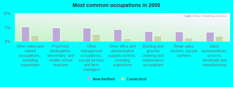
- Other sales and related occupations, including supervisors (5.2%)
- Preschool, kindergarten, elementary, and middle school teachers (4.9%)
- Other management occupations, except farmers and farm managers (4.7%)
- Other office and administrative support workers, including supervisors (4.2%)
- Building and grounds cleaning and maintenance occupations (3.5%)
- Retail sales workers, except cashiers (3.4%)
- Sales representatives, services, wholesale and manufacturing (3.3%)
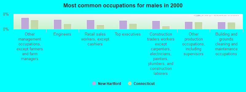
- Other management occupations, except farmers and farm managers (6.1%)
- Engineers (5.2%)
- Retail sales workers, except cashiers (5.1%)
- Top executives (4.7%)
- Construction traders workers except carpenters, electricians, painters, plumbers, and construction laborers (4.6%)
- Other production occupations, including supervisors (4.0%)
- Building and grounds cleaning and maintenance occupations (3.9%)
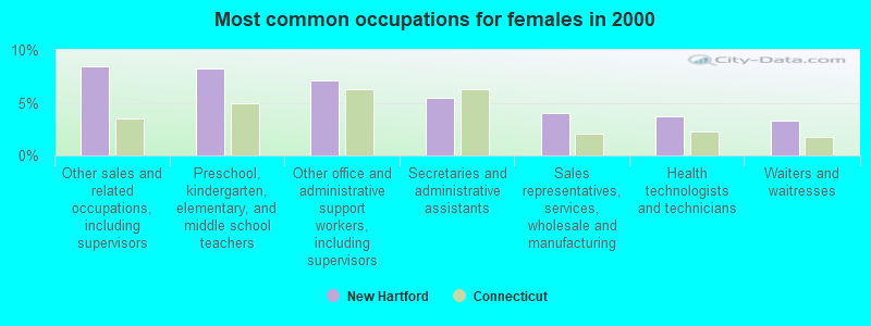
- Other sales and related occupations, including supervisors (8.4%)
- Preschool, kindergarten, elementary, and middle school teachers (8.2%)
- Other office and administrative support workers, including supervisors (7.1%)
- Secretaries and administrative assistants (5.5%)
- Sales representatives, services, wholesale and manufacturing (4.0%)
- Health technologists and technicians (3.7%)
- Waiters and waitresses (3.3%)
Average climate in New Hartford, Connecticut
Based on data reported by over 4,000 weather stations


(lower is better)
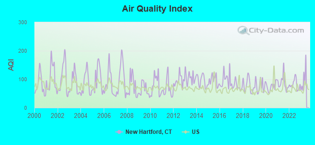
Air Quality Index (AQI) level in 2022 was 81.3. This is about average.
| City: | 81.3 |
| U.S.: | 72.6 |
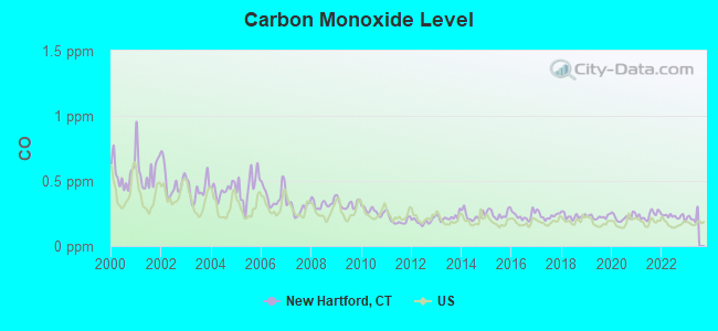
Carbon Monoxide (CO) [ppm] level in 2022 was 0.227. This is about average. Closest monitor was 14.9 miles away from the city center.
| City: | 0.227 |
| U.S.: | 0.251 |
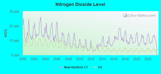
Nitrogen Dioxide (NO2) [ppb] level in 2022 was 10.7. This is significantly worse than average. Closest monitor was 6.8 miles away from the city center.
| City: | 10.7 |
| U.S.: | 5.1 |
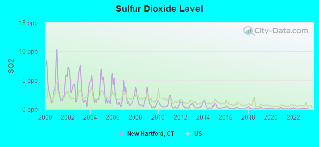
Sulfur Dioxide (SO2) [ppb] level in 2022 was 0.109. This is significantly better than average. Closest monitor was 6.8 miles away from the city center.
| City: | 0.109 |
| U.S.: | 1.515 |
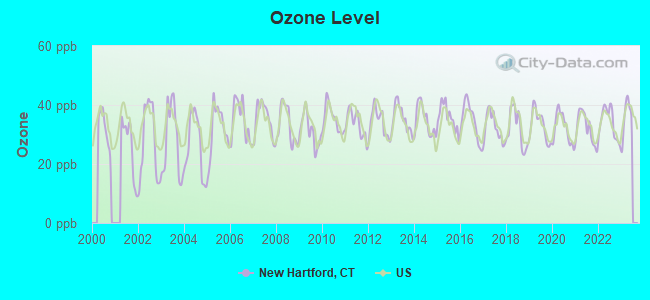
Ozone [ppb] level in 2022 was 34.0. This is about average. Closest monitor was 6.8 miles away from the city center.
| City: | 34.0 |
| U.S.: | 33.3 |
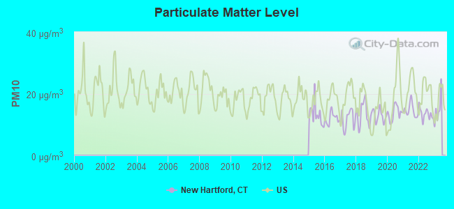
Particulate Matter (PM10) [µg/m3] level in 2022 was 13.4. This is significantly better than average. Closest monitor was 6.9 miles away from the city center.
| City: | 13.4 |
| U.S.: | 19.2 |
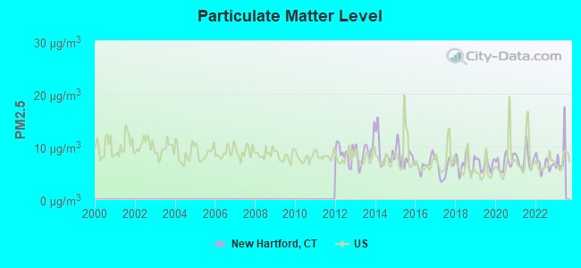
Particulate Matter (PM2.5) [µg/m3] level in 2022 was 6.57. This is better than average. Closest monitor was 14.9 miles away from the city center.
| City: | 6.57 |
| U.S.: | 8.11 |
Tornado activity:
New Hartford-area historical tornado activity is slightly above Connecticut state average. It is 15% smaller than the overall U.S. average.
On 10/3/1979, a category F4 (max. wind speeds 207-260 mph) tornado 17.4 miles away from the New Hartford town center killed 3 people and injured 500 people and caused between $50,000,000 and $500,000,000 in damages.
On 5/29/1995, a category F4 tornado 23.5 miles away from the town center killed 3 people and injured 24 people and caused between $5,000,000 and $50,000,000 in damages.
Earthquake activity:
New Hartford-area historical earthquake activity is significantly above Connecticut state average. It is 70% smaller than the overall U.S. average.On 10/7/1983 at 10:18:46, a magnitude 5.3 (5.1 MB, 5.3 LG, 5.1 ML, Class: Moderate, Intensity: VI - VII) earthquake occurred 160.3 miles away from New Hartford center
On 4/20/2002 at 10:50:47, a magnitude 5.3 (5.3 ML, Depth: 3.0 mi) earthquake occurred 187.2 miles away from New Hartford center
On 4/20/2002 at 10:50:47, a magnitude 5.2 (5.2 MB, 4.2 MS, 5.2 MW, 5.0 MW) earthquake occurred 185.7 miles away from the city center
On 1/19/1982 at 00:14:42, a magnitude 4.7 (4.5 MB, 4.7 MD, 4.5 LG, Class: Light, Intensity: IV - V) earthquake occurred 134.5 miles away from the city center
On 10/16/2012 at 23:12:25, a magnitude 4.7 (4.7 ML, Depth: 10.0 mi) earthquake occurred 169.7 miles away from New Hartford center
On 8/23/2011 at 17:51:04, a magnitude 5.8 (5.8 MW, Depth: 3.7 mi) earthquake occurred 377.9 miles away from New Hartford center
Magnitude types: regional Lg-wave magnitude (LG), body-wave magnitude (MB), duration magnitude (MD), local magnitude (ML), surface-wave magnitude (MS), moment magnitude (MW)
Natural disasters:
The number of natural disasters in Litchfield County (23) is greater than the US average (15).Major Disasters (Presidential) Declared: 13
Emergencies Declared: 10
Causes of natural disasters: Storms: 7, Hurricanes: 5, Floods: 4, Snowstorms: 4, Blizzards: 3, Snows: 2, Tropical Storms: 2, Winter Storms: 2, Snowfall: 1, Tornado: 1, Wind: 1 (Note: some incidents may be assigned to more than one category).
Hospitals and medical centers near New Hartford:
- C I B: CARRIAGE DRIVE (Hospital, about 4 miles away; BURLINGTON, CT)
- VALERIE MANOR (Nursing Home, about 5 miles away; TORRINGTON, CT)
- CHERRY BROOK HEALTH CARE CENTE (Nursing Home, about 5 miles away; COLLINSVILLE, CT)
- WEST REGION-N W C BLDG 2 (Hospital, about 6 miles away; TORRINGTON, CT)
- FOOTHILLS VN HOME CARE INC (Home Health Center, about 6 miles away; WINSTED, CT)
- FOOTHILLS VISITING NURSE AND H (Hospital, about 6 miles away; WINSTED, CT)
- HIGHLAND ACRES R H (Nursing Home, about 6 miles away; WINSTED, CT)
Amtrak stations near New Hartford:
- 18 miles: HARTFORD (1 UNION PLACE) . Services: ticket office, partially wheelchair accessible, enclosed waiting area, public restrooms, public payphones, full-service food facilities, snack bar, vending machines, ATM, paid short-term parking, paid long-term parking, call for car rental service, taxi stand, intercity bus service, public transit connection.
- 19 miles: WINDSOR (41 CENTRAL ST.) . Services: enclosed waiting area, public restrooms, public payphones, free short-term parking, call for car rental service, call for taxi service, public transit connection.
- 20 miles: BERLIN (KENSINGTON, DEPOT RD.) . Services: ticket office, partially wheelchair accessible, enclosed waiting area, public restrooms, public payphones, free short-term parking, free long-term parking, call for car rental service, call for taxi service, public transit connection.
Colleges/universities with over 2000 students nearest to New Hartford:
- Tunxis Community College (about 13 miles; Farmington, CT; Full-time enrollment: 2,787)
- University of Hartford (about 16 miles; West Hartford, CT; FT enrollment: 6,398)
- Central Connecticut State University (about 17 miles; New Britain, CT; FT enrollment: 9,989)
- Trinity College (about 18 miles; Hartford, CT; FT enrollment: 2,355)
- Capital Community College (about 19 miles; Hartford, CT; FT enrollment: 2,609)
- Goodwin College (about 21 miles; East Hartford, CT; FT enrollment: 3,017)
- University of Connecticut-Tri-Campus (about 21 miles; Waterbury, CT; FT enrollment: 2,250)
Public elementary/middle schools in New Hartford:
- ANN ANTOLINI SCHOOL (Students: 279, Location: 30 ANTOLINI ROAD, Grades: 3-6)
- BAKERVILLE CONSOLIDATED SCHOOL (Students: 198, Location: 51 CEDAR LANE, Grades: KG-2)
- NEW HARTFORD ELEMENTARY SCHOOL (Students: 154, Location: 40 WICKETT STREET, Grades: PK-2)
- BRIDGES II AT ANN ANTOLINI SCHOOL (Location: 30 ANTOLINI DRIVE, Grades: 4-6)
Libraries in New Hartford:
- LICIA & MASON BEEKLEY COMMUNITY LIBRARY (Operating income: $317,784; Location: 10 CENTRAL AVE.; 45,741 books; 18 e-books; 2,442 audio materials; 3,067 video materials; 2 local licensed databases; 30 state licensed databases; 70 print serial subscriptions)
- BAKERVILLE LIBRARY, INC. (Operating income: $54,891; Location: 6 MAPLE HOLLOW RD.; 15,778 books; 1,100 audio materials; 885 video materials; 30 state licensed databases; 30 print serial subscriptions)
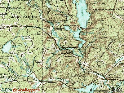
Points of interest:
Notable locations in New Hartford: Satans Kingdom (A), Camp Workcoeman (B), Camp Trinita (C), Maple Hollow (D), Camp Sequassen (E), Camp Pioneer (F), New Hartford Industrial Park (G), Camp Berkshire (H), Greenwoods Industrial Park (I), Greenwood Industrial Park (J), New Hartford Town Hall (K), New Hartford Historical Society Museum (L), New Hartford Free Public Library (M), Bakerville Library (N), New Hartford Volunteer Ambulance Service (O), New Hartford Fire Marshal's Office (P), Pine Meadow Volunteer Fire Department (Q), New Hartford Fire Department Station 1 (R), New Hartford Fire Department Station 2 (S). Display/hide their locations on the map
Shopping Center: Foothills Shopping Plaza Shopping Center (1). Display/hide its location on the map
Churches in New Hartford include: Bakerville Methodist Church (A), Immaculate Conception Church (B), Nepaug Congregational Church (C). Display/hide their locations on the map
Cemeteries: Pine Grove Cemetery (1), Nepaug Cemetery (2), Immaculate Conception Cemetery (3). Display/hide their locations on the map
Lakes, reservoirs, and swamps: Atwood Swamp (A), Rizzo Pond (B), Laurel Lake (C), Compensating Reservoir (D), Nepaug Reservoir (E), West Hill Pond (F), Collinsville Reservoir (G), New Hartford Reservoir (H). Display/hide their locations on the map
Streams, rivers, and creeks: Marandus Brook (A), North Nepaug Brook (B), Ratlum Brook (C), South Nepaug Brook (D), Spruce Brook (E), Bakersville Brook (F), Beckwith Brook (G), Cedar Swamp Brook (H), West Branch Farmington River (I). Display/hide their locations on the map
Parks in New Hartford include: Brodie Park (1), Browns Corner Recreation Area (2), Callahan Park (3). Display/hide their locations on the map
Tourist attractions: J & J Casey (Amusement & Theme Parks; 152 Main Street) (1), Main Stream Canoes & Kayaks (Amusement & Theme Parks; 170 Main Street) (2), Dattco (Tours & Charters; 26 South Road) (3). Display/hide their approximate locations on the map
Hotel: Alcove Motel (87 Main Street) (1). Display/hide its approximate location on the map
Court: Hartland Town - Emergency Medical- Probate Court (530 Main Street) (1). Display/hide its approximate location on the map
Birthplace of: Orlando Allen - 18th mayor of Buffalo.
Drinking water stations with addresses in New Hartford and their reported violations in the past:
NEW HARTFORD WATER DEPARTMENT (Population served: 1,343, Groundwater):Past monitoring violations:LITTLE BROOK RD PROPERTY OWNERS ASSN (Population served: 64, Groundwater):
- Follow-up Or Routine LCR Tap M/R - In OCT-01-2009, Contaminant: Lead and Copper Rule. Follow-up actions: St Compliance achieved (FEB-17-2010), St Violation/Reminder Notice (FEB-24-2010)
- Monitoring and Reporting (DBP) - Between OCT-2007 and DEC-2007, Contaminant: Chlorine. Follow-up actions: St Compliance achieved (FEB-25-2008), St Violation/Reminder Notice (MAR-14-2008)
- One minor monitoring violation
Past monitoring violations:ROCKTREE APARTMENTS (Population served: 60, Groundwater):
- 8 regular monitoring violations
Past monitoring violations:
- Follow-up Or Routine LCR Tap M/R - In OCT-01-2009, Contaminant: Lead and Copper Rule. Follow-up actions: St Public Notif requested (FEB-26-2010), St Violation/Reminder Notice (FEB-26-2010), St Public Notif received (JUL-01-2010)
- Follow-up Or Routine LCR Tap M/R - In OCT-10-2006, Contaminant: Lead and Copper Rule. Follow-up actions: St AO (w/penalty) issued (APR-16-2007), St Public Notif requested (APR-16-2007), St Public Notif received (JUL-12-2007), St Compliance achieved (SEP-18-2009)
- 2 routine major monitoring violations
- 19 regular monitoring violations
| This town: | 2.6 people |
| Connecticut: | 2.5 people |
| This town: | 76.6% |
| Whole state: | 66.3% |
| This town: | 5.9% |
| Whole state: | 6.6% |
Likely homosexual households (counted as self-reported same-sex unmarried-partner households)
- Lesbian couples: 0.5% of all households
- Gay men: 0.4% of all households
| This town: | 1.6% |
| Whole state: | 7.9% |
People in group quarters in New Hartford in 2010:
- 10 people in group homes intended for adults
- 5 people in other noninstitutional facilities
- 4 people in correctional residential facilities
11 people in other noninstitutional group quarters in 2000
Banks with branches in New Hartford (2011 data):
- Northwest Community Bank: New Hartford Branch at 141b Main Street, branch established on 1970/06/06. Info updated 2006/11/03: Bank assets: $318.9 mil, Deposits: $225.9 mil, headquarters in Winsted, CT, positive income, Mortgage Lending Specialization, 7 total offices, Holding Company: Connecticut Mutual Holding Company
- The Torrington Savings Bank: New Hartford Branch at 518 Main Street, branch established on 2011/08/25. Info updated 2006/11/03: Bank assets: $799.6 mil, Deposits: $660.7 mil, headquarters in Torrington, CT, positive income, Mortgage Lending Specialization, 8 total offices
For population 15 years and over in New Hartford:
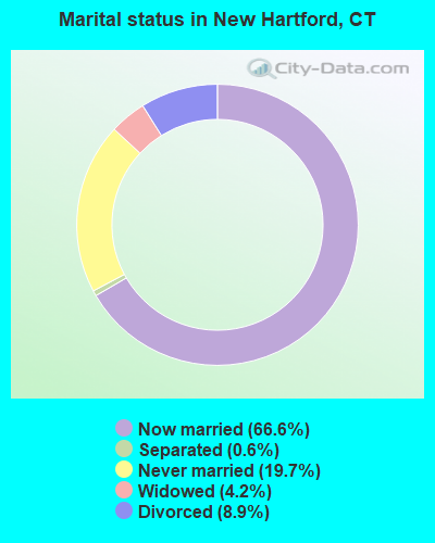
- Never married: 19.7%
- Now married: 66.6%
- Separated: 0.6%
- Widowed: 4.2%
- Divorced: 8.9%
For population 25 years and over in New Hartford:
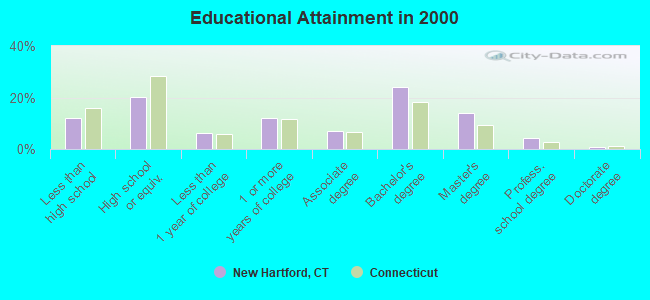
- High school or higher: 88.1%
- Bachelor's degree or higher: 42.8%
- Graduate or professional degree: 18.7%
- Unemployed: 2.9%
- Mean travel time to work (commute): 29.1 minutes
| Here: | 11.1 |
| Connecticut average: | 12.8 |
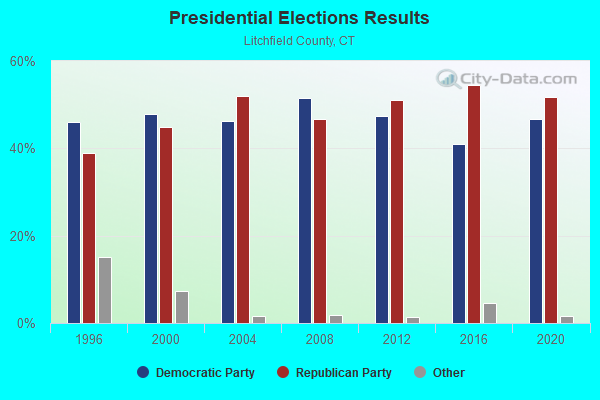
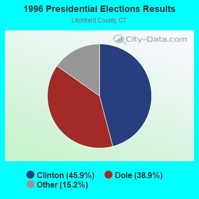
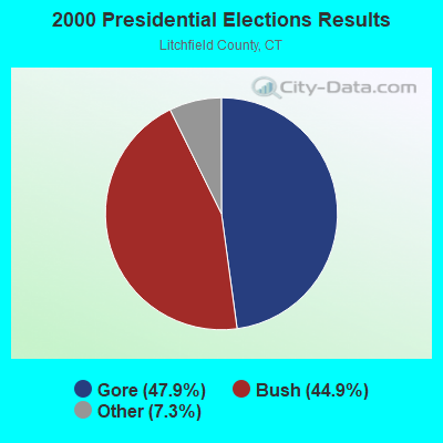
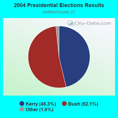
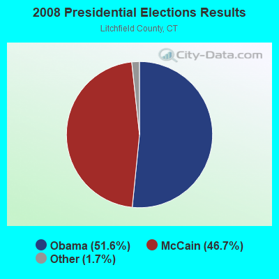
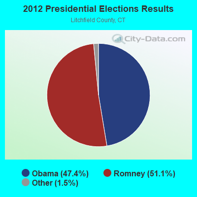
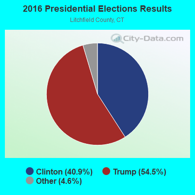
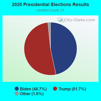
Graphs represent county-level data. Detailed 2008 Election Results
Religion statistics for New Hartford, CT (based on Litchfield County data)
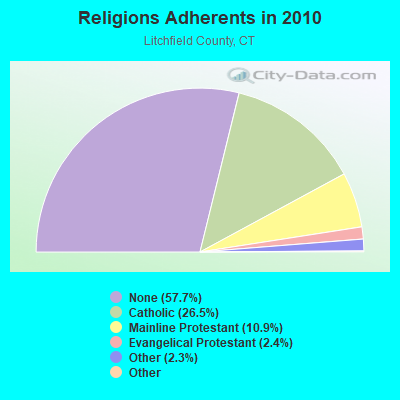
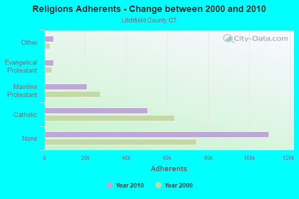
| Religion | Adherents | Congregations |
|---|---|---|
| Catholic | 50,354 | 30 |
| Mainline Protestant | 20,681 | 87 |
| Evangelical Protestant | 4,483 | 39 |
| Other | 4,420 | 16 |
| Orthodox | 175 | 2 |
| Black Protestant | 160 | 2 |
| None | 109,654 | - |
Food Environment Statistics:
| Litchfield County: | 2.29 / 10,000 pop. |
| State: | 2.21 / 10,000 pop. |
| Litchfield County: | 0.05 / 10,000 pop. |
| Connecticut: | 0.07 / 10,000 pop. |
| Litchfield County: | 0.64 / 10,000 pop. |
| Connecticut: | 1.02 / 10,000 pop. |
| Litchfield County: | 2.98 / 10,000 pop. |
| Connecticut: | 2.27 / 10,000 pop. |
| Here: | 11.07 / 10,000 pop. |
| Connecticut: | 9.19 / 10,000 pop. |
| Litchfield County: | 6.9% |
| Connecticut: | 7.3% |
| Litchfield County: | 21.1% |
| State: | 21.5% |
| Litchfield County: | 11.8% |
| Connecticut: | 15.8% |
| Businesses in New Hartford, CT | ||||
| Name | Count | Name | Count | |
|---|---|---|---|---|
| Dunkin Donuts | 1 | Subway | 1 | |
| Home Depot | 1 | U-Haul | 1 | |
Strongest AM radio stations in New Hartford:
- WTIC (1080 AM; 50 kW; HARTFORD, CT; Owner: INFINITY RADIO OPERATIONS INC.)
- WNNZ (640 AM; 50 kW; WESTFIELD, MA; Owner: CLEAR CHANNEL BROADCASTING LICENSES, INC.)
- WSNG (610 AM; 1 kW; TORRINGTON, CT; Owner: BUCKLEY BROADCASTING CORPORATION OF)
- WLAT (910 AM; 5 kW; NEW BRITAIN, CT; Owner: MEGA COMMUNICATIONS OF NEW BRITAIN LICENSEE, LLC)
- WDZK (1550 AM; 5 kW; BLOOMFIELD, CT; Owner: ABC, INC.)
- WCRN (830 AM; 50 kW; WORCESTER, MA; Owner: CARTER BROADCASTING CORPORATION)
- WDRC (1360 AM; 5 kW; HARTFORD, CT; Owner: BUCKLEY BROADCASTING CORPORATION)
- WPOP (1410 AM; 5 kW; HARTFORD, CT; Owner: CAPSTAR TX LIMITED PARTNERSHIP)
- WFAN (660 AM; 50 kW; NEW YORK, NY; Owner: INFINITY BROADCASTING OPERATIONS, INC.)
- WVNE (760 AM; daytime; 25 kW; LEICESTER, MA; Owner: BLOUNT MASSCOM, INC.)
- WHYN (560 AM; 5 kW; SPRINGFIELD, MA; Owner: CLEAR CHANNEL BROADCASTING LICENSES, INC.)
- WALE (990 AM; 50 kW; GREENVILLE, RI; Owner: NORTH AMERICAN BROADCASTING CO., INC.)
- WMCA (570 AM; 50 kW; NEW YORK, NY; Owner: SALEM MEDIA OF NEW YORK, LLC)
Strongest FM radio stations in New Hartford:
- WJMJ (88.9 FM; HARTFORD, CT; Owner: ST. THOMAS SEMINARY)
- WRCH (100.5 FM; NEW BRITAIN, CT; Owner: INFINITY RADIO OPERATIONS INC.)
- WTIC-FM (96.5 FM; HARTFORD, CT; Owner: INFINITY RADIO OPERATIONS INC.)
- WWUH (91.3 FM; WEST HARTFORD, CT; Owner: UNIVERSITY OF HARTFORD)
- WCCC-FM (106.9 FM; HARTFORD, CT; Owner: MARLIN BROADCASTING, LLC)
- WZBG (97.3 FM; LITCHFIELD, CT; Owner: LOCAL GIRLS & BOYS B/CASTING CORP.)
- WAPJ (89.9 FM; TORRINGTON, CT; Owner: NUTMEG CONSERVATORY FOR THE ARTS, INC.)
- WWYZ (92.5 FM; WATERBURY, CT; Owner: CAPSTAR TX LIMITED PARTNERSHIP)
- WKSS (95.7 FM; HARTFORD-MERIDEN, CT; Owner: CAPSTAR TX LIMITED PARTNERSHIP)
- WHCN (105.9 FM; HARTFORD, CT; Owner: CAPSTAR TX LIMITED PARTNERSHIP)
- WZMX (93.7 FM; HARTFORD, CT; Owner: INFINITY RADIO OPERATIONS INC.)
- WMRQ (104.1 FM; WATERBURY, CT; Owner: CAPSTAR TX LIMITED PARTNERSHIP)
- WPKT (90.5 FM; MERIDEN, CT; Owner: CONNECTICUT PUBLIC BROADCASTING, INC)
- WDRC-FM (102.9 FM; HARTFORD, CT; Owner: BUCKLEY BROADCASTING CORPORATION)
- WAQY (102.1 FM; SPRINGFIELD, MA; Owner: SAGA COMMUNICATIONS OF NEW ENGLAND, LLC)
- WKCI-FM (101.3 FM; HAMDEN, CT; Owner: CLEAR CHANNEL BROADCASTING LICENSES, INC.)
- WPLR (99.1 FM; NEW HAVEN, CT; Owner: COX RADIO, INC.)
- W218AV (91.5 FM; WARREN, CT; Owner: MONROE BOARD OF EDUCATION)
- WHYN-FM (93.1 FM; SPRINGFIELD, MA; Owner: CLEAR CHANNEL BROADCASTING LICENSES, INC.)
- WAMC-FM (90.3 FM; ALBANY, NY; Owner: WAMC)
TV broadcast stations around New Hartford:
- WTIC-TV (Channel 61; HARTFORD, CT; Owner: TRIBUNE TELEVISION COMPANY)
- W11BJ (Channel 11; HARTFORD, CT; Owner: COMMUNICATIONS SITE MANAGEMENT LLC)
- WUVN (Channel 18; HARTFORD, CT; Owner: ENTRAVISION HOLDINGS, LLC)
- WTXX (Channel 20; WATERBURY, CT; Owner: WTXX INC.)
- WVIT (Channel 30; NEW BRITAIN, CT; Owner: OUTLET BROADCASTING, INC)
- WEDH (Channel 24; HARTFORD, CT; Owner: CONNECTICUT PUBLIC BROADCASTING, INC.)
- WFSB (Channel 3; HARTFORD, CT; Owner: MEREDITH CORPORATION)
- WHCT-LP (Channel 38; HARTFORD, CT; Owner: VENTURE TECHNOLOGIES GROUP, LLC)
- WTNH (Channel 8; NEW HAVEN, CT; Owner: WTNH BROADCASTING, INC.)
- WCTX (Channel 59; NEW HAVEN, CT; Owner: WTNH BROADCASTING, INC.)
- WEDY (Channel 65; NEW HAVEN, CT; Owner: CONNECTICUT PUBLIC BROADCASTING, INC.)
- WWLP (Channel 22; SPRINGFIELD, MA; Owner: WWLP BROADCASTING, LLC)
- WYDN (Channel 48; WORCESTER, MA; Owner: EDUCATIONAL PUBLIC TV CORPORATION)
- WHTX-LP (Channel 10; HARTFORD, CT; Owner: ENTRAVISION HOLDINGS, LLC)
- WRDM-LP (Channel 13; HARTFORD, CT; Owner: ZGS HARTFORD, INC.)
- WMLD-LP (Channel 6; HARTFORD, CT; Owner: HARVARD BROADCASTING, INC.)
- WUTH-CA (Channel 47; HARTFORD, CT; Owner: ENTRAVISION HOLDINGS, LLC)
- National Bridge Inventory (NBI) Statistics
- 19Number of bridges
- 161ft / 49.1mTotal length
- 262,948Total average daily traffic
- 18,955Total average daily truck traffic
- 390,714Total future (year 2035) average daily traffic
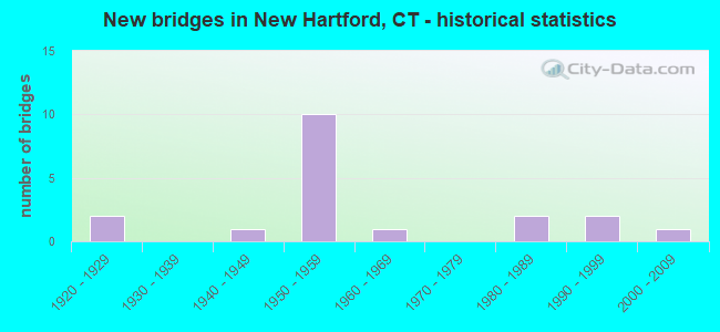
- New bridges - historical statistics
- 21920-1929
- 11940-1949
- 101950-1959
- 11960-1969
- 21980-1989
- 21990-1999
- 12000-2009
FCC Registered Antenna Towers:
2- Douglas I Brandon, 20 Antolini Road (Lat: 41.828056 Lon: -73.015556), Type: 30.1, Overall height: 30.1 m, Registrant: At&t Wireless Services, Inc., Esther.Hilliard@attws.Com, , Washi-ngton, Phone: (202) 223-9222
- Douglas I Brandon, 20 Antolini Road (Lat: 41.828056 Lon: -73.015556), Type: 30.1, Overall height: 30.1 m, Registrant: At&t Wireless Services, Inc., Esther.Hilliard@attws.Com, , Washi-ngton, Phone: (202) 223-9222
FCC Registered Private Land Mobile Towers:
1- 10 Arrowhead Road (Lat: 41.874167 Lon: -73.020556), Type: Tower, Structure height: 18 m, Overall height: 22 m, Call Sign: WPTV254, Licensee ID: L00371772,
Assigned Frequencies: 929.162 MHz, Grant Date: 12/13/2011, Expiration Date: 12/20/2021, Cancellation Date: 02/05/2022, Certifier: Alan Gawel, Registrant: Litchfield County Dispatch Inc, 111 Water Street, Torrington, CT 06790, Phone: (860) 626-7525, Fax: (860) 626-7527, Email:
FCC Registered Broadcast Land Mobile Towers:
6- West Hill Fire House Burwell Rd (Lat: 41.874556 Lon: -72.882889), Call Sign: KUQ797,
Assigned Frequencies: 155.895 MHz, Grant Date: 11/01/2022, Expiration Date: 11/05/2032, Registrant: Pittsfield Communications Systems Inc., 1502 West Housatonic St., Pittsfield, MA 01201, Phone: (413) 448-8214, Fax: (413) 448-6263, Email:
- Lat: 41.875083 Lon: -72.957889, Call Sign: WPMH433,
Assigned Frequencies: 151.955 MHz, Grant Date: 07/25/2023, Expiration Date: 07/28/2033, Certifier: Robert F Kobles, Registrant: Ski Sundown Inc, New Hartford, CT 06057, Phone: (860) 379-7669, Fax: (860) 480-5229, Email:
- 10 Arrowhead Road (Lat: 41.874167 Lon: -73.020556), Type: Gtower, Structure height: 18 m, Overall height: 22 m, Call Sign: WPTL616,
Assigned Frequencies: 155.092 MHz, 155.107 MHz, 155.122 MHz, 157.450 MHz, Grant Date: 08/04/2021, Expiration Date: 10/25/2031, Certifier: Alan T Gawel, Registrant: Northeastern Communications, 7 Great Hill Rd, Naugatuck, CT 06770, Phone: (203) 575-9008, Email:
- 10 Arrowhead Rd. West Hill Station (Lat: 41.874167 Lon: -73.020556), Type: Tower, Structure height: 12.2 m, Overall height: 18 m, Call Sign: WPXV832,
Assigned Frequencies: 155.295 MHz, Grant Date: 07/19/2023, Expiration Date: 06/18/2033, Certifier: William F Baxter, Registrant: New Hartford, Town Of, Main Street, New Hartford, CT 06057, Phone: (860) 379-3389, Fax: (860) 379-0940, Email:
- L1, Lat: 41.829167 Lon: -73.016389, Call Sign: WQUY630,
Assigned Frequencies: 159.585 MHz, 159.810 MHz, 159.945 MHz, 160.080 MHz, 160.140 MHz, Grant Date: 11/18/2014, Expiration Date: 11/18/2024, Certifier: Chris Barberet, Registrant: Bearcom Operating LP, Dallas, TX 75355-9001, Phone: (214) 765-7328, Fax: (214) 355-4971, Email:
- Lat: 41.833083 Lon: -73.034639, Call Sign: WQWV550,
Assigned Frequencies: 456.187 MHz, 456.362 MHz, 457.762 MHz, 462.287 MHz, 462.362 MHz, Grant Date: 12/02/2015, Expiration Date: 12/02/2025, Certifier: Dr. Roxanne Pangallo, Registrant: Bearcom Operating LLC, Dallas, TX 75355-9001, Phone: (800) 458-9887, Email:
FCC Registered Paging Towers:
1- Camp Sequessen, West Pond Lake (Lat: 41.883417 Lon: -73.051111), Type: Tower, Structure height: 36.6 m, Overall height: 42.7 m, Call Sign: KNKJ900,
Assigned Frequencies: 158.100 MHz, Grant Date: 04/27/1999, Expiration Date: 04/01/2009, Cancellation Date: 03/09/2009, Certifier: John T Scott Iii, Registrant: American Messaging Services, LLC, 1720 Lakepointe Drive, #100, Lewisville, TX 75057, Phone: (214) 222-6460, Fax: (972) 353-1912, Email:
FCC Registered Amateur Radio Licenses:
62 (See the full list of FCC Registered Amateur Radio Licenses in New Hartford)FAA Registered Aircraft:
6- Aircraft: PIPER PA-28-181 (Category: Land, Seats: 4, Weight: Up to 12,499 Pounds, Speed: 105 mph), Engine: LYCOMING O&VO-360 SER (180 HP) (Reciprocating)
N-Number: 325AV, N325AV, N-325AV, Serial Number: 28-7990346, Year manufactured: 1979, Airworthiness Date: 03/01/1979, Certificate Issue Date: 06/11/1997
Registrant (Corporation): Silver City Flying Club Inc, C/O Timothy P Suydam Treasurer / 83 West Rd, New Hartford, CT 06057 - Aircraft: CESSNA 172G (Category: Land, Seats: 4, Weight: Up to 12,499 Pounds, Speed: 105 mph), Engine: CONT MOTOR 0-300 SER (145 HP) (Reciprocating)
N-Number: 3813L, N3813L, N-3813L, Serial Number: 17253982, Year manufactured: 1965, Airworthiness Date: 12/29/1965, Certificate Issue Date: 12/03/2019
Registrant (Individual): David W Buyak, 281 Cedar Ln, New Hartford, CT 06057 - Aircraft: SIX CHUTER WEST LLC LEGEND XL (Category: Land, Seats: 2, Weight: Up to 12,499 Pounds), Engine: 4 Cycle
N-Number: 408SC, N408SC, N-408SC, Serial Number: 3164, Certificate Issue Date: 06/27/2016
Registrant (Individual): Charles K Thomas, 14 Bakerville Ter, New Hartford, CT 06057 - Aircraft: PIPER J3C-65 (Category: Land, Seats: 2, Weight: Up to 12,499 Pounds, Speed: 67 mph), Engine: Reciprocating
N-Number: 70721, N70721, N-70721, Serial Number: 17759, Certificate Issue Date: 09/23/2003
Registrant (Individual): Timothy G Wells, 6 Greenwoods Rd, New Hartford, CT 06057 - Aircraft: CESSNA 310Q (Category: Land, Engines: 2, Seats: 6, Weight: Up to 12,499 Pounds, Speed: 167 mph), Engine: CONT MOTOR I0-470 SERIES (260 HP) (Reciprocating)
N-Number: 347DL, N347DL, N-347DL, Serial Number: 310Q0113, Year manufactured: 1970, Airworthiness Date: 06/25/1970, Certificate Issue Date: 06/05/2018
Registrant (Individual): Donald P Jr Procaccini, 1300 Litchfield Tpke, New Hartford, CT 06057 - Aircraft: CESSNA 180C (Category: Land, Seats: 4, Weight: Up to 12,499 Pounds, Speed: 121 mph), Engine: CONT MOTOR O-470 SERIES (230 HP) (Reciprocating)
N-Number: 98DF, N98DF, N-98DF, Serial Number: 50714, Year manufactured: 1960, Airworthiness Date: 01/29/1960, Certificate Issue Date: 12/22/2015
Registrant (Individual): Donald P Jr Procaccini, 1300 Litchfield Tpke, New Hartford, CT 06057
2002 - 2018 National Fire Incident Reporting System (NFIRS) incidents
- Fire incident types reported to NFIRS in New Hartford, CT
- 22755.6%Structure Fires
- 11127.2%Outside Fires
- 399.6%Mobile Property/Vehicle Fires
- 317.6%Other
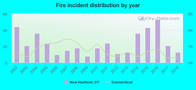 Based on the data from the years 2002 - 2018 the average number of fire incidents per year is 24. The highest number of reported fires - 53 took place in 2016, and the least - 8 in 2009. The data has a decreasing trend.
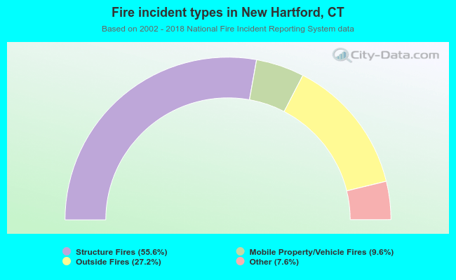 When looking into fire subcategories, the most reports belonged to: Structure Fires (55.6%), and Outside Fires (27.2%).
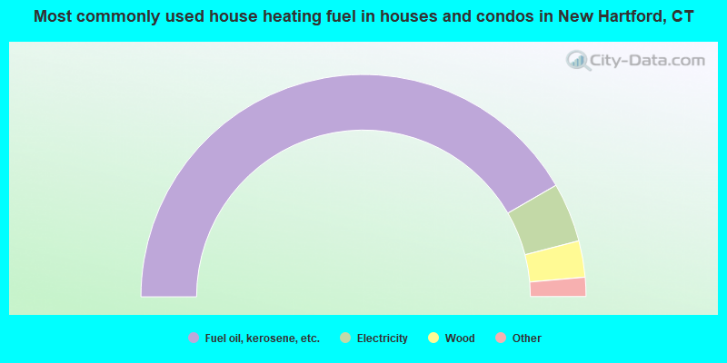
- 83.3%Fuel oil, kerosene, etc.
- 8.6%Electricity
- 5.3%Wood
- 1.5%Bottled, tank, or LP gas
- 0.9%Utility gas
- 0.4%Other fuel
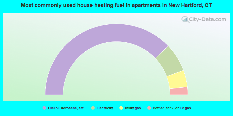
- 75.8%Fuel oil, kerosene, etc.
- 12.9%Electricity
- 7.6%Utility gas
- 3.6%Bottled, tank, or LP gas
New Hartford compared to Connecticut state average:
- Unemployed percentage significantly below state average.
- Black race population percentage significantly below state average.
- Hispanic race population percentage significantly below state average.
- Median age above state average.
- Foreign-born population percentage significantly below state average.
- Renting percentage significantly below state average.
- Length of stay since moving in significantly above state average.
- Number of rooms per house significantly below state average.
- House age significantly below state average.
New Hartford on our top lists:
- #12 on the list of "Top 101 cities with largest percentage of females in occupations: religious workers (population 5,000+)"
- #13 on the list of "Top 101 cities with largest percentage of males in occupations: drafters, engineering, and mapping technicians (population 5,000+)"
- #16 on the list of "Top 101 cities with largest percentage of males in occupations: art and design workers (population 5,000+)"
- #17 on the list of "Top 101 cities with largest percentage of females in occupations: other sales and related workers including supervisors (population 5,000+)"
- #17 on the list of "Top 101 cities with largest percentage of females in industries: apparel, fabrics, and notions merchant wholesalers (population 5,000+)"
- #18 on the list of "Top 101 cities with largest percentage of females in occupations: secondary school teachers (population 5,000+)"
- #27 on the list of "Top 101 cities with largest percentage of females in industries: finance and insurance (population 5,000+)"
- #29 on the list of "Top 101 cities with largest percentage of males in occupations: retail sales workers except cashiers (population 5,000+)"
- #32 on the list of "Top 101 cities with largest percentage of females in industries: hardware, plumbing and heating equipment, and supplies merchant wholesalers (population 5,000+)"
- #41 on the list of "Top 101 cities with largest percentage of females in industries: furniture and home furnishing merchant wholesalers (population 5,000+)"
- #50 on the list of "Top 101 cities with largest percentage of females in industries: jewelry, luggage, and leather goods stores (population 5,000+)"
- #53 on the list of "Top 101 cities with largest percentage of males in industries: furniture and home furnishings, and household appliance stores (population 5,000+)"
- #61 on the list of "Top 101 cities with largest percentage of males in industries: electrical and electronic goods merchant wholesalers (population 5,000+)"
- #75 on the list of "Top 101 cities with largest percentage of females in industries: electrical equipment, appliances, and components (population 5,000+)"
- #77 on the list of "Top 101 cities with largest percentage of males in industries: furniture and related product manufacturing (population 5,000+)"
- #91 on the list of "Top 101 cities with largest percentage of males in industries: health and personal care, except drug, stores (population 5,000+)"
- #95 on the list of "Top 101 cities with largest percentage of females in industries: electronic shopping and mail-order houses (population 5,000+)"
- #96 on the list of "Top 101 cities with largest percentage of females in industries: used merchandise, gift, novelty, and souvenir, and other miscellaneous stores (population 5,000+)"
- #99 on the list of "Top 101 cities with largest percentage of females in industries: office supplies and stationery stores (population 5,000+)"
- #7 on the list of "Top 101 counties with the lowest Particulate Matter (PM10) Annual air pollution readings in 2012 (µg/m3)"
- #10 on the list of "Top 101 counties with the lowest number of births per 1000 residents 2007-2013"
- #21 on the list of "Top 101 counties with the largest decrease in the number of births per 1000 residents 2000-2006 to 2007-2013 (pop 50,000+)"
- #38 on the list of "Top 101 counties with the lowest Particulate Matter (PM2.5) Annual air pollution readings in 2012 (µg/m3)"
- #39 on the list of "Top 101 counties with the highest carbon monoxide air pollution readings in 2012 (ppm)"

|
|
Total of 175 patent applications in 2008-2024.