Norfolk, Connecticut
Submit your own pictures of this town and show them to the world
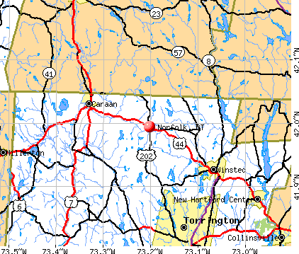
- OSM Map
- General Map
- Google Map
- MSN Map
Population change since 2000: +3.0%
 |
| Males: 837 | |
| Females: 872 |
| Median resident age: | 47.7 years |
| Connecticut median age: | 39.2 years |
Zip codes: 06058.
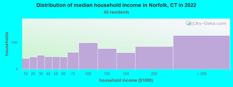
| Norfolk: | $96,579 |
| CT: | $88,429 |
Estimated per capita income in 2022: $61,002 (it was $34,020 in 2000)
Norfolk town income, earnings, and wages data
Estimated median house or condo value in 2022: $407,301 (it was $188,400 in 2000)
| Norfolk: | $407,301 |
| CT: | $347,200 |
Mean prices in 2022: all housing units: $429,743; detached houses: $455,293; townhouses or other attached units: $232,674; in 2-unit structures: $242,050; in 3-to-4-unit structures: $229,634; in 5-or-more-unit structures: $182,162; mobile homes: $243,504; occupied boats, rvs, vans, etc.: $127,144
Detailed information about poverty and poor residents in Norfolk, CT
Compare current foreclosures near Norfolk, CT:
| Photo | Address | Area | Beds / Baths | Price | Details |
|---|---|---|---|---|---|

|
#1
Litchfield Rd
Norfolk, CT 06058
|
3,678 sq. feet
|
3 baths 6 beds |
$665,500
|
show details |

|
#2
Woodbine St
Torrington, CT 06790
|
2,756 sq. feet
|
3 baths 6 beds |
$419,900
|
show details |

|
#3
Old New Hartford Rd
Winsted, CT 06098
|
1,560 sq. feet
|
1 baths 4 beds |
$319,900
|
show details |

|
#4
Benton St
Winsted, CT 06098
|
1,109 sq. feet
|
2 baths 2 beds |
show details | |

|
#5
Elmira Ave
Torrington, CT 06790
|
1,242 sq. feet
|
2 baths 3 beds |
show details | |

|
#6
E Litchfield Rd S
Litchfield, CT 06759
|
1,353 sq. feet
|
1 baths 2 beds |
show details | |

|
#7
Alum Hill Road
Sheffield, MA 01257
|
1,040 sq. feet
|
2 baths 3 beds |
show details | |

|
#8
White Pine Rd
Torrington, CT 06790
|
1,536 sq. feet
|
2 baths 3 beds |
show details | |

|
#9
Beach St
Litchfield, CT 06759
|
2,624 sq. feet
|
2 baths 4 beds |
show details | |

|
#10
Marcia Dr
Torrington, CT 06790
|
1,496 sq. feet
|
2 baths 4 beds |
show details |
| Photo | Address | Area | Beds / Baths | Price | Details |
|---|---|---|---|---|---|

|
#11
Cookes Rdg
Torrington, CT 06790
|
872 sq. feet
|
1 baths 2 beds |
show details | |

|
#12
Pearl St
Torrington, CT 06790
|
1,344 sq. feet
|
1 baths 2 beds |
show details | |

|
#13
Crestwood Rd
Torrington, CT 06790
|
2,380 sq. feet
|
2 baths 4 beds |
show details | |

|
#14
Nelson St
Torrington, CT 06790
|
1,256 sq. feet
|
1 baths 3 beds |
show details | |

|
#15
Putnam St
Torrington, CT 06790
|
1,400 sq. feet
|
2 baths 3 beds |
show details | |

|
#16
Cherry St
Torrington, CT 06790
|
2,398 sq. feet
|
3 baths 9 beds |
show details | |

|
#17
Moore Dr
Torrington, CT 06790
|
1,236 sq. feet
|
2 baths 3 beds |
show details | |

|
#18
Cooper St
Torrington, CT 06790
|
3,913 sq. feet
|
2 baths 6 beds |
show details | |

|
#19
Nutmeg Dr
Torrington, CT 06790
|
872 sq. feet
|
1 baths 4 beds |
show details | |

|
#20
Willow St
Torrington, CT 06790
|
2,076 sq. feet
|
2 baths 5 beds |
show details |
| Photo | Address | Area | Beds / Baths | Price | Details |
|---|---|---|---|---|---|

|
#21
S Undermountain Rd
Sheffield, MA 01257
|
1,713 sq. feet
|
2 baths 3 beds |
show details | |

|
#22
Mcguinness St
Torrington, CT 06790
|
1,049 sq. feet
|
1 baths 3 beds |
show details | |

|
#23
Litchfield St # 1
Torrington, CT 06790
|
1,990 sq. feet
|
2 baths 4 beds |
show details | |

|
#24
Circle Dr
Torrington, CT 06790
|
1,226 sq. feet
|
2 baths 3 beds |
show details | |

|
#25
New Litchfield St
Torrington, CT 06790
|
1,325 sq. feet
|
1 baths 3 beds |
show details | |

|
#26
Hillcrest St
Torrington, CT 06790
|
1,230 sq. feet
|
2 baths 3 beds |
show details | |

|
#27
Vista Dr
Harwinton, CT 06791
|
1,933 sq. feet
|
1 baths 3 beds |
show details | |

|
#28
Amenia Rd
Sharon, CT 06069
|
3,126 sq. feet
|
4 baths 4 beds |
show details | |

|
#29
S Lake St # A
Litchfield, CT 06759
|
3,962 sq. feet
|
3 baths 7 beds |
show details | |

|
#30
Calhoun St
Torrington, CT 06790
|
1,740 sq. feet
|
2 baths 6 beds |
show details |
| Photo | Address | Area | Beds / Baths | Price | Details |
|---|---|---|---|---|---|

|
#31
Berry St
Torrington, CT 06790
|
2,496 sq. feet
|
3 baths 6 beds |
show details | |

|
#32
Yale Ave
Torrington, CT 06790
|
1,196 sq. feet
|
1 baths 2 beds |
show details | |

|
#33
Fox Den Rd
Granville, MA 01034
|
984 sq. feet
|
1 baths 2 beds |
show details | |

|
#34
S Sandisfield Rd
Great Barrington, MA 01230
|
1,983 sq. feet
|
2 baths 2 beds |
show details | |

|
#35
Hillside Pl
Winsted, CT 06098
|
1,861 sq. feet
|
1 baths 3 beds |
show details | |

|
#36
N Main St
Winsted, CT 06098
|
1,839 sq. feet
|
2 baths 4 beds |
show details | |

|
#37
E Mountain Ave
Winsted, CT 06098
|
1,835 sq. feet
|
2 baths 4 beds |
show details | |

|
#38
Strong Ter
Winsted, CT 06098
|
1,590 sq. feet
|
1 baths 4 beds |
show details | |

|
#39
Greenwoods Rd
Torrington, CT 06790
|
1,038 sq. feet
|
1 baths 3 beds |
show details | |

|
#40
Main St
Sheffield, MA 01257
|
3,683 sq. feet
|
5 baths 6 beds |
show details |
| Photo | Address | Area | Beds / Baths | Price | Details |
|---|---|---|---|---|---|

|
#41
Greenwoods Rd
Torrington, CT 06790
|
1,848 sq. feet
|
1 baths 3 beds |
show details | |

|
#42
Cedar Ln
Torrington, CT 06790
|
1,502 sq. feet
|
2 baths 3 beds |
show details | |

|
#43
Dennison Dr
Torrington, CT 06790
|
1,330 sq. feet
|
1 baths 3 beds |
show details | |

|
#44
Wildcat Hill Rd
Harwinton, CT 06791
|
1,834 sq. feet
|
2 baths 4 beds |
show details | |

|
#45
Wood Duck Dr
Torrington, CT 06790
|
1,884 sq. feet
|
2 baths 4 beds |
show details | |

|
#46
Jordan Ln
Torrington, CT 06790
|
1,550 sq. feet
|
2 baths 3 beds |
show details | |

|
#47
County Rd
Great Barrington, MA 01230
|
1,576 sq. feet
|
1 baths 4 beds |
show details | |

|
#48
Old Post Rd 3, Lot 10
Millerton, NY 12546
|
- sq. feet
|
- baths - beds |
show details | |

|
#49
Rhoades And Bailey Rd
Mill River, MA 01244
|
- sq. feet
|
- baths - beds |
show details | |

|
Check over 1 million property listings on Foreclosure.com!
|
browse all offers | |||


- 1,63795.8%White alone
- 301.8%Hispanic
- 160.9%Two or more races
- 120.7%Black alone
- 110.6%Asian alone
- 20.1%American Indian alone
- 10.06%Other race alone
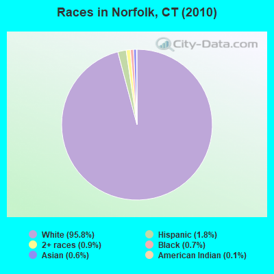
Races in Norfolk detailed stats: ancestries, foreign born residents, place of birth
According to our research of Connecticut and other state lists, there were 2 registered sex offenders living in Norfolk, Connecticut as of April 27, 2024.
The ratio of all residents to sex offenders in Norfolk is 855 to 1.
The ratio of registered sex offenders to all residents in this city is near the state average.
 Recent articles from our blog. Our writers, many of them Ph.D. graduates or candidates, create easy-to-read articles on a wide variety of topics.

 | 2024 Connecticut Town Tournament VI (Celebrating the 10-Year Anniversary & Dazzleman's Memorial) (705 replies) |
| Current Real estate markets (3987 replies) |
| Connecticut TOWN TOURNAMENT V (2022) (831 replies) |
| Connecticut TOWN TOURNAMENT IV (2020) (849 replies) |
| Connecticut Weather Discussion 3 (8061 replies) |
| Connecticut Fall Foliage (380 replies) |
Latest news from Norfolk, CT collected exclusively by city-data.com from local newspapers, TV, and radio stations
Norfolk, CT City Guides:
Ancestries: Irish (20.6%), English (17.7%), Italian (15.1%), German (11.4%), French (10.4%), Polish (5.0%).
Current Local Time: EST time zone
Incorporated on 10/1758
Elevation: 1230 feet
Land area: 45.3 square miles.
Population density: 38 people per square mile (very low).
87 residents are foreign born (3.6% Europe, 1.0% Asia).
| This town: | 5.2% |
| Connecticut: | 10.9% |
| Norfolk town: | 1.6% ($3,051) |
| Connecticut: | 1.8% ($2,961) |
Nearest city with pop. 50,000+: Bristol, CT  (25.0 miles , pop. 60,062).
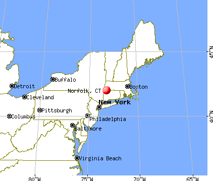
Nearest city with pop. 200,000+: Bronx, NY (86.4 miles , pop. 1,332,650).
Nearest cities:
), ), ), ), ), )Latitude: 41.99 N, Longitude: 73.19 W
Area code: 860

Norfolk tourist attractions:
Single-family new house construction building permits:
- 2022: 1 building, cost: $575,000
- 2021: 4 buildings, average cost: $750,000
- 2020: 1 building, cost: $1,000,000
- 2017: 3 buildings, average cost: $233,300
- 2016: 5 buildings, average cost: $31,700
- 2015: 1 building, cost: $490,000
- 2014: 2 buildings, average cost: $765,000
- 2012: 1 building, cost: $160,000
- 2011: 1 building, cost: $315,000
- 2010: 2 buildings, average cost: $415,000
- 2009: 1 building, cost: $175,000
- 2008: 3 buildings, average cost: $322,700
- 2007: 4 buildings, average cost: $450,000
- 2006: 2 buildings, average cost: $200,000
- 2005: 7 buildings, average cost: $301,800
- 2004: 3 buildings, average cost: $186,300
- 2003: 6 buildings, average cost: $266,500
- 2002: 2 buildings, average cost: $200,000
- 2001: 3 buildings, average cost: $177,300
- 2000: 4 buildings, average cost: $620,600
- 1999: 5 buildings, average cost: $196,500
- 1998: 2 buildings, average cost: $170,000
- 1997: 3 buildings, average cost: $101,700
| Here: | 3.2% |
| Connecticut: | 3.9% |
- Educational services (14.1%)
- Health care (10.9%)
- Construction (9.4%)
- Professional, scientific, technical services (6.9%)
- Finance & insurance (4.3%)
- Accommodation & food services (4.1%)
- Administrative & support & waste management services (3.9%)
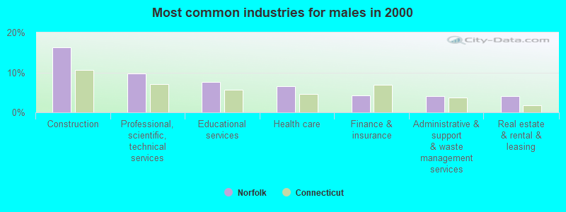
- Construction (16.3%)
- Professional, scientific, technical services (9.8%)
- Educational services (7.6%)
- Health care (6.5%)
- Finance & insurance (4.3%)
- Administrative & support & waste management services (4.1%)
- Real estate & rental & leasing (4.1%)
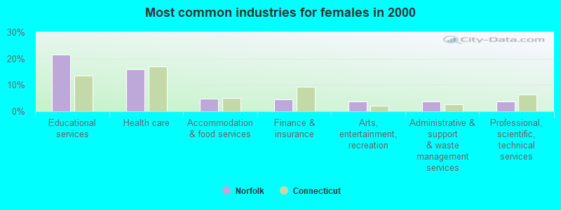
- Educational services (21.5%)
- Health care (15.9%)
- Accommodation & food services (4.8%)
- Finance & insurance (4.4%)
- Arts, entertainment, recreation (3.7%)
- Administrative & support & waste management services (3.7%)
- Professional, scientific, technical services (3.7%)
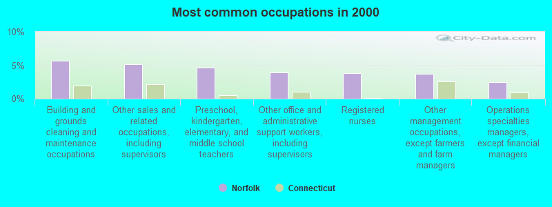
- Building and grounds cleaning and maintenance occupations (5.6%)
- Other sales and related occupations, including supervisors (5.2%)
- Preschool, kindergarten, elementary, and middle school teachers (4.7%)
- Other office and administrative support workers, including supervisors (3.9%)
- Registered nurses (3.8%)
- Other management occupations, except farmers and farm managers (3.7%)
- Operations specialties managers, except financial managers (2.5%)
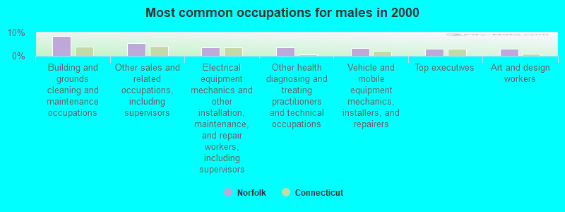
- Building and grounds cleaning and maintenance occupations (8.4%)
- Other sales and related occupations, including supervisors (5.3%)
- Electrical equipment mechanics and other installation, maintenance, and repair workers, including supervisors (3.7%)
- Other health diagnosing and treating practitioners and technical occupations (3.7%)
- Vehicle and mobile equipment mechanics, installers, and repairers (3.5%)
- Top executives (3.1%)
- Art and design workers (3.1%)
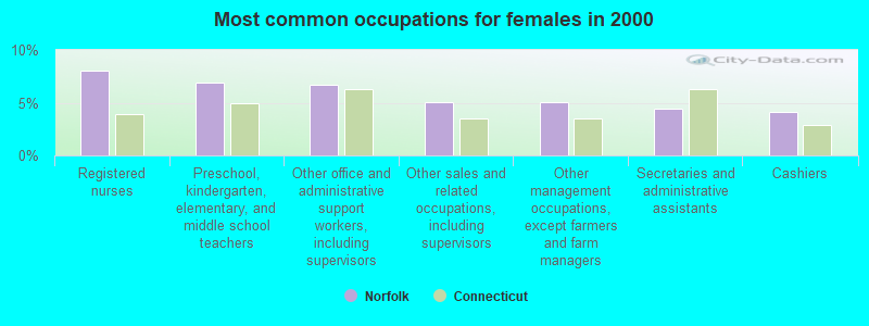
- Registered nurses (8.1%)
- Preschool, kindergarten, elementary, and middle school teachers (6.9%)
- Other office and administrative support workers, including supervisors (6.7%)
- Other sales and related occupations, including supervisors (5.1%)
- Other management occupations, except farmers and farm managers (5.1%)
- Secretaries and administrative assistants (4.4%)
- Cashiers (4.2%)
Average climate in Norfolk, Connecticut
Based on data reported by over 4,000 weather stations


(lower is better)
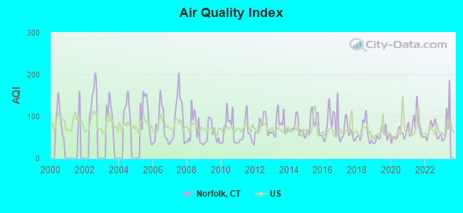
Air Quality Index (AQI) level in 2022 was 64.1. This is about average.
| City: | 64.1 |
| U.S.: | 72.6 |
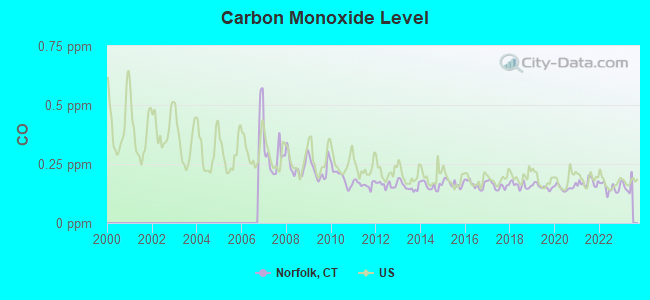
Carbon Monoxide (CO) [ppm] level in 2022 was 0.149. This is significantly better than average. Closest monitor was 12.6 miles away from the city center.
| City: | 0.149 |
| U.S.: | 0.251 |
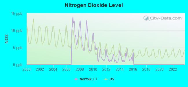
Nitrogen Dioxide (NO2) [ppb] level in 2015 was 2.27. This is significantly better than average. Closest monitor was 12.6 miles away from the city center.
| City: | 2.27 |
| U.S.: | 5.11 |
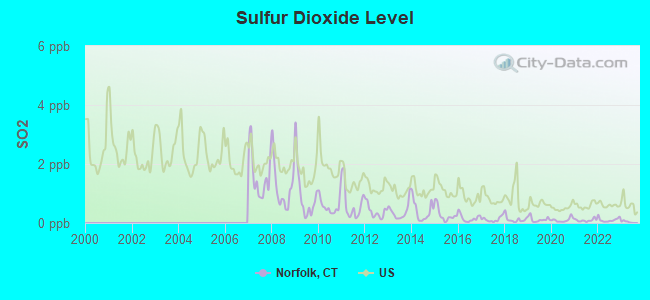
Sulfur Dioxide (SO2) [ppb] level in 2022 was 0.109. This is significantly better than average. Closest monitor was 12.6 miles away from the city center.
| City: | 0.109 |
| U.S.: | 1.515 |
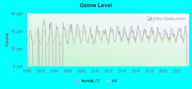
Ozone [ppb] level in 2022 was 37.6. This is about average. Closest monitor was 10.2 miles away from the city center.
| City: | 37.6 |
| U.S.: | 33.3 |
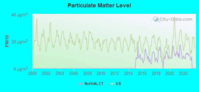
Particulate Matter (PM10) [µg/m3] level in 2022 was 9.49. This is significantly better than average. Closest monitor was 12.6 miles away from the city center.
| City: | 9.49 |
| U.S.: | 19.21 |
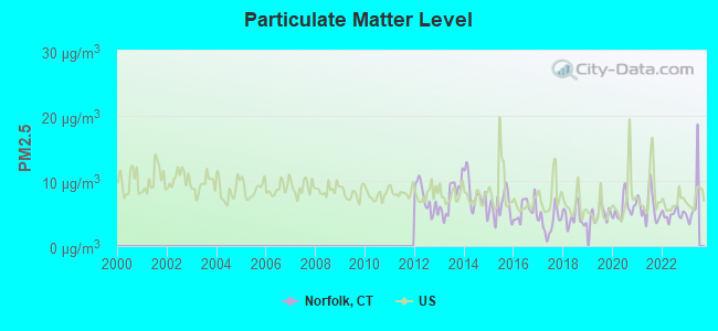
Particulate Matter (PM2.5) [µg/m3] level in 2022 was 4.86. This is significantly better than average. Closest monitor was 12.6 miles away from the city center.
| City: | 4.86 |
| U.S.: | 8.11 |
Tornado activity:
Norfolk-area historical tornado activity is slightly above Connecticut state average. It is 15% smaller than the overall U.S. average.
On 5/29/1995, a category F4 (max. wind speeds 207-260 mph) tornado 12.7 miles away from the Norfolk town center killed 3 people and injured 24 people and caused between $5,000,000 and $50,000,000 in damages.
On 8/28/1973, a category F4 tornado 21.8 miles away from the town center killed 4 people and injured 36 people and caused between $5,000,000 and $50,000,000 in damages.
Earthquake activity:
Norfolk-area historical earthquake activity is significantly above Connecticut state average. It is 69% smaller than the overall U.S. average.On 10/7/1983 at 10:18:46, a magnitude 5.3 (5.1 MB, 5.3 LG, 5.1 ML, Class: Moderate, Intensity: VI - VII) earthquake occurred 147.9 miles away from the city center
On 4/20/2002 at 10:50:47, a magnitude 5.3 (5.3 ML, Depth: 3.0 mi) earthquake occurred 176.5 miles away from Norfolk center
On 4/20/2002 at 10:50:47, a magnitude 5.2 (5.2 MB, 4.2 MS, 5.2 MW, 5.0 MW) earthquake occurred 174.9 miles away from Norfolk center
On 1/19/1982 at 00:14:42, a magnitude 4.7 (4.5 MB, 4.7 MD, 4.5 LG, Class: Light, Intensity: IV - V) earthquake occurred 132.3 miles away from the city center
On 10/16/2012 at 23:12:25, a magnitude 4.7 (4.7 ML, Depth: 10.0 mi) earthquake occurred 170.3 miles away from Norfolk center
On 8/23/2011 at 17:51:04, a magnitude 5.8 (5.8 MW, Depth: 3.7 mi) earthquake occurred 377.7 miles away from the city center
Magnitude types: regional Lg-wave magnitude (LG), body-wave magnitude (MB), duration magnitude (MD), local magnitude (ML), surface-wave magnitude (MS), moment magnitude (MW)
Natural disasters:
The number of natural disasters in Litchfield County (23) is greater than the US average (15).Major Disasters (Presidential) Declared: 13
Emergencies Declared: 10
Causes of natural disasters: Storms: 7, Hurricanes: 5, Floods: 4, Snowstorms: 4, Blizzards: 3, Snows: 2, Tropical Storms: 2, Winter Storms: 2, Snowfall: 1, Tornado: 1, Wind: 1 (Note: some incidents may be assigned to more than one category).

Hospitals and medical centers near Norfolk:
- C R I - SPENCER HILL ROAD (Hospital, about 8 miles away; WINSTED, CT)
- C R I BOYD STREET (Hospital, about 8 miles away; WINSTED, CT)
- HIGHLAND ACRES R H (Nursing Home, about 8 miles away; WINSTED, CT)
- LAUREL HILL HEALTHCARE (Nursing Home, about 8 miles away; WINSTED, CT)
- FOOTHILLS VN HOME CARE INC (Home Health Center, about 8 miles away; WINSTED, CT)
- FOOTHILLS VISITING NURSE AND H (Hospital, about 8 miles away; WINSTED, CT)
- GEER NURSING AND REHABILITATIO (Nursing Home, about 9 miles away; CANAAN, CT)
Colleges/universities with over 2000 students nearest to Norfolk:
- Westfield State University (about 23 miles; Westfield, MA; Full-time enrollment: 5,548)
- Tunxis Community College (about 26 miles; Farmington, CT; FT enrollment: 2,787)
- University of Hartford (about 28 miles; West Hartford, CT; FT enrollment: 6,398)
- Central Connecticut State University (about 30 miles; New Britain, CT; FT enrollment: 9,989)
- Capital Community College (about 31 miles; Hartford, CT; FT enrollment: 2,609)
- Trinity College (about 31 miles; Hartford, CT; FT enrollment: 2,355)
- Naugatuck Valley Community College (about 31 miles; Waterbury, CT; FT enrollment: 4,491)
Public elementary/middle school in Norfolk:
- BOTELLE ELEMENTARY SCHOOL (Students: 158, Location: 128 GREENWOODS ROAD EAST, Grades: PK-6)
Points of interest:
Notable locations in Norfolk: Norfolk Town Hall (A), Norfolk Library (B), Norfolk Historical Society Museum (C), Norfolk Historical Society Building (D), Norfolk Lions Club Ambulance (E), Norfolk Volunteer Fire Department (F), Norfolk Fire Marshal's Office (G). Display/hide their locations on the map
Churches in Norfolk include: Church of the Immaculate Conception Roman Catholic Church (A), Church of the Transfiguration Episcopal Church (B). Display/hide their locations on the map
Cemetery: Center Cemetery (1). Display/hide its location on the map
Streams, rivers, and creeks: Norfolk Brook (A), Spaulding Brook (B), Wood Creek (C). Display/hide their locations on the map
Parks in Norfolk include: Bigelow Park (1), Norfolk Village Green (2), Norfolk Historic District (3). Display/hide their locations on the map
Tourist attraction: Norfolk Historical Society (Museums; Village Green).
Hotels: Blackberry River Inn (538 Greenwoods Road West), Mountain View Inn (Litchfield Road), Manor House Inn (69 Maple Avenue).
Court: Norfolk Town - Administrative Departments- Probate Court (19 Maple Avenue).
Birthplace of: Reuben Gaylord - Congregationalist cleric, Thomas Robbins (minister) - First librarian of the Connecticut Historical Society, William H. Welch - Americna scientist.
| This town: | 2.4 people |
| Connecticut: | 2.5 people |
| This town: | 66.5% |
| Whole state: | 66.3% |
| This town: | 10.0% |
| Whole state: | 6.6% |
Likely homosexual households (counted as self-reported same-sex unmarried-partner households)
- Lesbian couples: 0.3% of all households
- Gay men: 2.1% of all households
| This town: | 4.1% |
| Whole state: | 7.9% |
| This town: | 1.5% |
| Whole state: | 3.9% |
11 people in other nonhousehold living situations in 2000
Banks with branches in Norfolk (2011 data):
- The National Iron Bank: Norfolk Branch at 2 John J Curtiss Road, branch established on 1966/07/01. Info updated 2006/11/03: Bank assets: $101.4 mil, Deposits: $91.6 mil, headquarters in Salisbury, CT, positive income, Mortgage Lending Specialization, 4 total offices, Holding Company: Iron Bancshares, Inc.
For population 15 years and over in Norfolk:
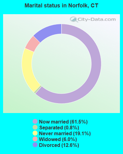
- Never married: 19.1%
- Now married: 61.5%
- Separated: 0.8%
- Widowed: 6.0%
- Divorced: 12.6%
For population 25 years and over in Norfolk:
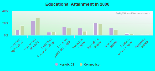
- High school or higher: 91.3%
- Bachelor's degree or higher: 37.1%
- Graduate or professional degree: 16.8%
- Unemployed: 2.7%
- Mean travel time to work (commute): 26.4 minutes
| Here: | 11.1 |
| Connecticut average: | 12.8 |
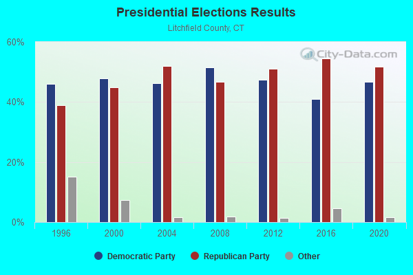
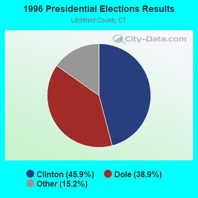
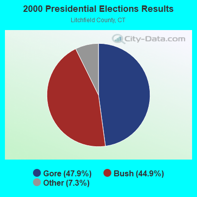
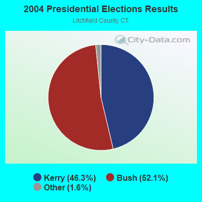
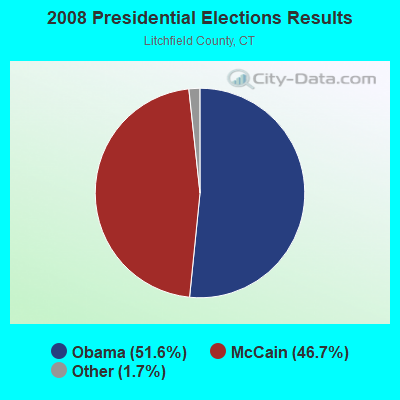
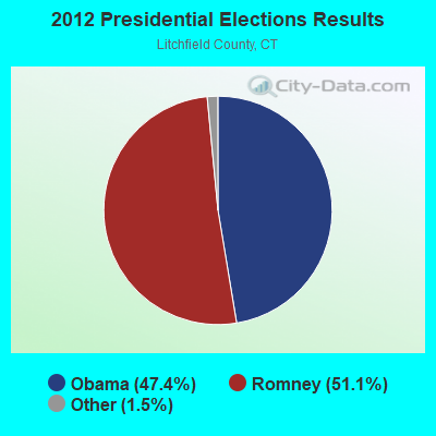
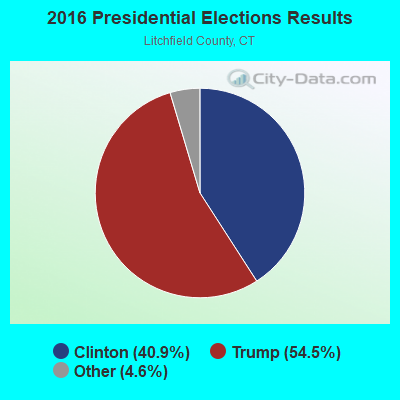
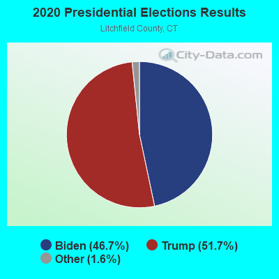
Graphs represent county-level data. Detailed 2008 Election Results
Religion statistics for Norfolk, CT (based on Litchfield County data)
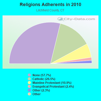
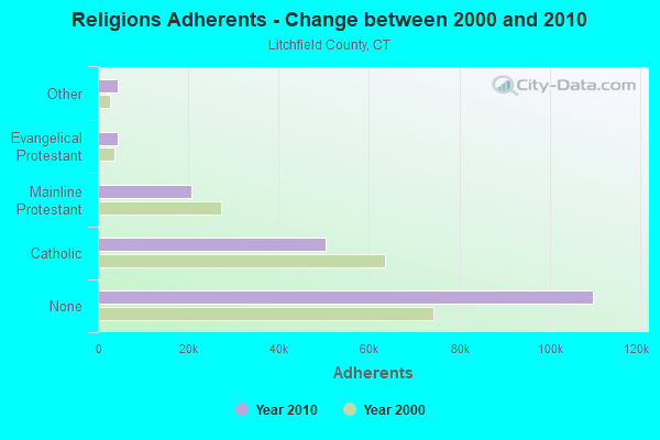
| Religion | Adherents | Congregations |
|---|---|---|
| Catholic | 50,354 | 30 |
| Mainline Protestant | 20,681 | 87 |
| Evangelical Protestant | 4,483 | 39 |
| Other | 4,420 | 16 |
| Orthodox | 175 | 2 |
| Black Protestant | 160 | 2 |
| None | 109,654 | - |
Food Environment Statistics:
| This county: | 2.29 / 10,000 pop. |
| Connecticut: | 2.21 / 10,000 pop. |
| Litchfield County: | 0.05 / 10,000 pop. |
| Connecticut: | 0.07 / 10,000 pop. |
| Litchfield County: | 0.64 / 10,000 pop. |
| Connecticut: | 1.02 / 10,000 pop. |
| This county: | 2.98 / 10,000 pop. |
| Connecticut: | 2.27 / 10,000 pop. |
| Litchfield County: | 11.07 / 10,000 pop. |
| Connecticut: | 9.19 / 10,000 pop. |
| Litchfield County: | 6.9% |
| Connecticut: | 7.3% |
| Here: | 21.1% |
| State: | 21.5% |
| Litchfield County: | 11.8% |
| Connecticut: | 15.8% |
Businesses in Norfolk, CT
- FedEx: 1
- U-Haul: 1
Strongest AM radio stations in Norfolk:
- WNNZ (640 AM; 50 kW; WESTFIELD, MA; Owner: CLEAR CHANNEL BROADCASTING LICENSES, INC.)
- WTIC (1080 AM; 50 kW; HARTFORD, CT; Owner: INFINITY RADIO OPERATIONS INC.)
- WCRN (830 AM; 50 kW; WORCESTER, MA; Owner: CARTER BROADCASTING CORPORATION)
- WGY (810 AM; 50 kW; SCHENECTADY, NY; Owner: CLEAR CHANNEL BROADCASTING LICENSES, INC.)
- WFAN (660 AM; 50 kW; NEW YORK, NY; Owner: INFINITY BROADCASTING OPERATIONS, INC.)
- WSBS (860 AM; 3 kW; GREAT BARRINGTON, MA; Owner: BERKSHIRE BROADCASTING CO., INC.)
- WHYN (560 AM; 5 kW; SPRINGFIELD, MA; Owner: CLEAR CHANNEL BROADCASTING LICENSES, INC.)
- WVNE (760 AM; daytime; 25 kW; LEICESTER, MA; Owner: BLOUNT MASSCOM, INC.)
- WPTR (1540 AM; 50 kW; ALBANY, NY; Owner: KIMTRON, INC.)
- WMCA (570 AM; 50 kW; NEW YORK, NY; Owner: SALEM MEDIA OF NEW YORK, LLC)
- WKZE (1020 AM; daytime; 2 kW; SHARON, CT; Owner: JOHNSON DEVELOPMENT, INC.)
- WCBS (880 AM; 50 kW; NEW YORK, NY; Owner: INFINITY BROADCASTING OPERATIONS, INC.)
- WABC (770 AM; 50 kW; NEW YORK, NY; Owner: WABC-AM RADIO, INC.)
Strongest FM radio stations in Norfolk:
- WSGG (89.3 FM; NORFOLK, CT; Owner: REVIVAL CHRISTIAN MINISTRIES, INC.)
- WAMQ (105.1 FM; GREAT BARRINGTON, MA; Owner: WAMC)
- WRCH (100.5 FM; NEW BRITAIN, CT; Owner: INFINITY RADIO OPERATIONS INC.)
- WHVP (91.1 FM; HUDSON, NY; Owner: SOUND OF LIFE, INC.)
- WAPJ (89.9 FM; TORRINGTON, CT; Owner: NUTMEG CONSERVATORY FOR THE ARTS, INC.)
- WAMC-FM (90.3 FM; ALBANY, NY; Owner: WAMC)
- WJMJ (88.9 FM; HARTFORD, CT; Owner: ST. THOMAS SEMINARY)
- WTIC-FM (96.5 FM; HARTFORD, CT; Owner: INFINITY RADIO OPERATIONS INC.)
- WKZE-FM (98.1 FM; SALISBURY, CT; Owner: JOHNSON DEVELOPMENT, INC.)
- WQQQ (103.3 FM; SHARON, CT; Owner: THE RIDGEFIELD BROADCASTING CORPORATION)
- WZBG (97.3 FM; LITCHFIELD, CT; Owner: LOCAL GIRLS & BOYS B/CASTING CORP.)
- WWUH (91.3 FM; WEST HARTFORD, CT; Owner: UNIVERSITY OF HARTFORD)
- W218AV (91.5 FM; WARREN, CT; Owner: MONROE BOARD OF EDUCATION)
- WCCC-FM (106.9 FM; HARTFORD, CT; Owner: MARLIN BROADCASTING, LLC)
- WAQY (102.1 FM; SPRINGFIELD, MA; Owner: SAGA COMMUNICATIONS OF NEW ENGLAND, LLC)
- WPDH (101.5 FM; POUGHKEEPSIE, NY; Owner: CUMULUS LICENSING CORP.)
- WHYN-FM (93.1 FM; SPRINGFIELD, MA; Owner: CLEAR CHANNEL BROADCASTING LICENSES, INC.)
- W206AW (89.1 FM; PAWLING, NY; Owner: SOUND OF LIFE, INC.)
- WAMK (90.9 FM; KINGSTON, NY; Owner: W A M C)
- WFGB (89.7 FM; KINGSTON, NY; Owner: SOUND OF LIFE, INC.)
TV broadcast stations around Norfolk:
- WTIC-TV (Channel 61; HARTFORD, CT; Owner: TRIBUNE TELEVISION COMPANY)
- W11BJ (Channel 11; HARTFORD, CT; Owner: COMMUNICATIONS SITE MANAGEMENT LLC)
- WTXX (Channel 20; WATERBURY, CT; Owner: WTXX INC.)
- WUVN (Channel 18; HARTFORD, CT; Owner: ENTRAVISION HOLDINGS, LLC)
- WVIT (Channel 30; NEW BRITAIN, CT; Owner: OUTLET BROADCASTING, INC)
- WEDH (Channel 24; HARTFORD, CT; Owner: CONNECTICUT PUBLIC BROADCASTING, INC.)
- WFSB (Channel 3; HARTFORD, CT; Owner: MEREDITH CORPORATION)
- WWLP (Channel 22; SPRINGFIELD, MA; Owner: WWLP BROADCASTING, LLC)
- WTNH (Channel 8; NEW HAVEN, CT; Owner: WTNH BROADCASTING, INC.)
- WHCT-LP (Channel 38; HARTFORD, CT; Owner: VENTURE TECHNOLOGIES GROUP, LLC)
- Norfolk, Connecticut
- Fatal accident count23
- Vehicles involved in fatal accidents34
- Fatal accidents involving drunk persons:11
- Fatalities25
- Persons involved in fatal accidents63
- Pedestrians involved in fatal accidents3
- Connecticut average
- Fatal accident count6521
- Vehicles involved in fatal accidents9573
- Fatal accidents involving drunk persons2842
- Fatalities7022
- Persons involved in fatal accidents15801
- Pedestrians involved in fatal accidents602
- National Bridge Inventory (NBI) Statistics
- 18Number of bridges
- 82ft / 25.0mTotal length
- $1,499,000Total costs
- 120,845Total average daily traffic
- 8,571Total average daily truck traffic
- 179,564Total future (year 2032) average daily traffic
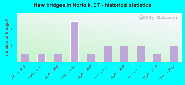
- New bridges - historical statistics
- 11920-1929
- 11930-1939
- 11940-1949
- 51950-1959
- 11960-1969
- 21970-1979
- 21980-1989
- 21990-1999
- 12000-2009
- 22010-2019
FCC Registered Cell Phone Towers:
1- 453 Loon Meadow Road (Lat: 42.009083 Lon: -73.180889), Type: Gtower, Structure height: 49.4 m, Overall height: 53 m, Call Sign: KNKN589
Assigned Frequencies: 880.020 MHz, 880.020 MHz, 880.020 MHz, 835.020 MHz, 835.020 MHz, 835.020 MHz, 891.510 MHz, 891.510 MHz, 891.510 MHz, 846.510 MHz, 846.510 MHz, 846.510 MHzGrant Date: 09/01/2020, Expiration Date: 10/01/2030, Certifier: David C JatlowRegistrant: At&t Services, Inc., 208 S Akard St, 20f, Dallas, TX 75202, Phone: (855) 699-7073, Fax: (214) 746-6410, Email:
FCC Registered Antenna Towers:
3- Richard Byrne, 10 Ashpohtag Rd (Lat: 42.002694 Lon: -73.221389), Type: 46.0, Overall height: 45.1 m, Registrant: Towerco Assets LLC, Afry@towerco.Com, , Cary, Phone: (919) 653-5710
- Richard Byrne, 10 Ashpohtag Rd (Lat: 42.002694 Lon: -73.221389), Type: 46.0, Overall height: 45.1 m, Registrant: Towerco Assets LLC, Afry@towerco.Com, , Cary, Phone: (919) 653-5710
- Edward G Roach, 10 Ashpohtag Rd (Lat: 42.002694 Lon: -73.221389), Type: 46.0, Structure height: 09005 m, Overall height: 45.1 m, Registrant: Sba 2012 Tc Assets, LLC, Eroach@sbasite.Com, , Boca -Raton, Phone: (561) 995-7670
FCC Registered Broadcast Land Mobile Towers:
9 (See the full list of FCC Registered Broadcast Land Mobile Towers in Norfolk, CT)FCC Registered Amateur Radio Licenses:
7- Call Sign: N1PNR, Licensee ID: L00302315, Grant Date: 04/12/2013, Expiration Date: 06/08/2023, Certifier: Kevin C Gundlach, Registrant: Kevin C Gundlach, 10 Ashpohtag Rd, Norfolk, CT 06058
- Call Sign: N1UQL, Licensee ID: L00941595, Grant Date: 02/24/2015, Expiration Date: 03/22/2025, Cancellation Date: 09/30/2016, Certifier: Stephen W Root, Registrant: Stephen W Root, Norfolk, CT 06058
- Call Sign: N1VOK, Licensee ID: L01018153, Grant Date: 09/15/2015, Expiration Date: 09/15/2025, Registrant: Andrew G Attanasio, Norfolk, CT 06058
- Call Sign: KC1KNT, Licensee ID: L02163304, Grant Date: 11/21/2018, Expiration Date: 11/21/2028, Cancellation Date: 01/01/2019, Certifier: William H Arquett, Registrant: William H Arquett, 54 Laurel Way Ext, Norfolk, CT 06058
- Call Sign: N1WHA, Previous Call Sign: KC1KNT, Licensee ID: L02163304, Grant Date: 01/01/2019, Expiration Date: 01/01/2029, Certifier: William H Arquett Dmd, Registrant: William H Arquett Dmd, 54 Laurel Way Ext, Norfolk, CT 06058
- Call Sign: KC1SJT, Licensee ID: L02630588, Grant Date: 01/25/2023, Expiration Date: 01/25/2033, Certifier: Gregory A Mitchell, Registrant: Gregory A Mitchell, Norfolk, CT 06058
- Call Sign: KC1SVM, Licensee ID: L02660685, Grant Date: 04/19/2023, Expiration Date: 04/19/2033, Certifier: Noah Sinclair, Registrant: Noah Sinclair, 24 Emerson St, Norfolk, CT 06058-1130
FAA Registered Aircraft:
3- Aircraft: CESSNA 182P (Category: Land, Seats: 4, Weight: Up to 12,499 Pounds, Speed: 120 mph), Engine: CONT MOTOR O 470R (230 HP) (Reciprocating)
N-Number: 691DM, N691DM, N-691DM, Serial Number: 18263984, Year manufactured: 1975, Airworthiness Date: 06/07/2001, Certificate Issue Date: 07/19/2016
Registrant (Corporation): 43rd Aviation Flying Club Inc, 1018 Litchfield Rd, Norfolk, CT 06058 - Aircraft: PIPER PA-28-181 (Category: Land, Seats: 4, Weight: Up to 12,499 Pounds, Speed: 105 mph), Engine: LYCOMING O&VO-360 SER (180 HP) (Reciprocating)
N-Number: 723PC, N723PC, N-723PC, Serial Number: 2843194, Year manufactured: 1998, Airworthiness Date: 11/09/1998, Certificate Issue Date: 03/03/2011
Registrant (Corporation): 43rd Aviation Flying Club Inc, 1018 Litchfield Rd, Norfolk, CT 06058 - Aircraft: DJI PHANTOM 2 VISION + (Category: Land, Engines: 4), Engine: Electric
N-Number: 952VF, N952VF, N-952VF, Serial Number: PH645396406 V3.0, Certificate Issue Date: 12/17/2015
Registrant (Corporation): Norfolk Volunteer Fire Dept, 20 Shepard Rd, Norfolk, CT 06058
2002 - 2018 National Fire Incident Reporting System (NFIRS) incidents
- Fire incident types reported to NFIRS in Norfolk, CT
- 24074.1%Structure Fires
- 3711.4%Outside Fires
- 3410.5%Other
- 134.0%Mobile Property/Vehicle Fires
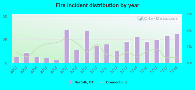 Based on the data from the years 2002 - 2018 the average number of fire incidents per year is 19. The highest number of reported fires - 35 took place in 2007, and the least - 3 in 2006. The data has a growing trend.
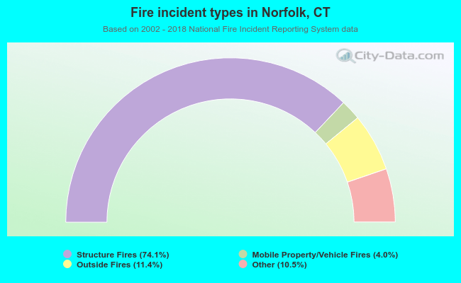 When looking into fire subcategories, the most incidents belonged to: Structure Fires (74.1%), and Outside Fires (11.4%).
- 87.8%Fuel oil, kerosene, etc.
- 4.6%Wood
- 2.4%Bottled, tank, or LP gas
- 2.4%Electricity
- 1.2%Coal or coke
- 1.2%Other fuel
- 0.4%Solar energy
- 83.7%Fuel oil, kerosene, etc.
- 10.7%Electricity
- 2.8%Wood
- 1.7%Bottled, tank, or LP gas
- 1.1%Utility gas
Norfolk compared to Connecticut state average:
- Unemployed percentage significantly below state average.
- Black race population percentage significantly below state average.
- Hispanic race population percentage significantly below state average.
- Median age significantly above state average.
- Foreign-born population percentage significantly below state average.
- Length of stay since moving in significantly above state average.
- Number of rooms per house significantly below state average.
- House age significantly below state average.
Norfolk on our top lists:
- #43 on the list of "Top 100 high-educated but low-earning cities"
- #7 on the list of "Top 101 counties with the lowest Particulate Matter (PM10) Annual air pollution readings in 2012 (µg/m3)"
- #10 on the list of "Top 101 counties with the lowest number of births per 1000 residents 2007-2013"
- #21 on the list of "Top 101 counties with the largest decrease in the number of births per 1000 residents 2000-2006 to 2007-2013 (pop 50,000+)"
- #38 on the list of "Top 101 counties with the lowest Particulate Matter (PM2.5) Annual air pollution readings in 2012 (µg/m3)"
- #39 on the list of "Top 101 counties with the highest carbon monoxide air pollution readings in 2012 (ppm)"

|
Total of 15 patent applications in 2008-2024.