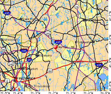
Norton, Massachusetts
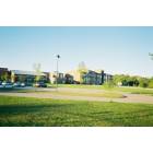
Norton: norton middle school
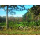
Norton: Crane Street Foliage

Norton: Norton Library
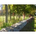
Norton: Stone Wall on Elm Street

Norton: Wheaton College
- add
your
Submit your own pictures of this town and show them to the world
- OSM Map
- General Map
- Google Map
- MSN Map
Population change since 2000: +5.5%
 |
| Males: 9,191 | |
| Females: 9,840 |
| Median resident age: | 38.2 years |
| Massachusetts median age: | 39.2 years |
Zip codes: 02766.
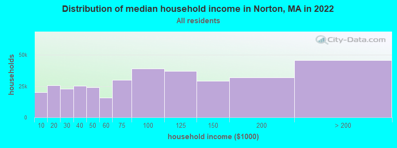
| Norton: | $121,528 |
| MA: | $94,488 |
Estimated per capita income in 2022: $48,685 (it was $23,876 in 2000)
Norton town income, earnings, and wages data
Estimated median house or condo value in 2022: $505,126 (it was $172,000 in 2000)
| Norton: | $505,126 |
| MA: | $534,700 |
Mean prices in 2022: all housing units: $449,660; detached houses: $484,124; townhouses or other attached units: $382,766; in 2-unit structures: $322,469; in 3-to-4-unit structures: $355,875; in 5-or-more-unit structures: $269,714; mobile homes: $156,871; occupied boats, rvs, vans, etc.: $49,834
Detailed information about poverty and poor residents in Norton, MA


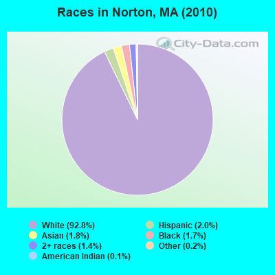
- 17,66992.8%White alone
- 3742.0%Hispanic
- 3381.8%Asian alone
- 3181.7%Black alone
- 2631.4%Two or more races
- 420.2%Other race alone
- 210.1%American Indian alone
- 60.03%Native Hawaiian and Other
Pacific Islander alone
Races in Norton detailed stats: ancestries, foreign born residents, place of birth
According to our research of Massachusetts and other state lists, there were 7 registered sex offenders living in Norton, Massachusetts as of April 27, 2024.
The ratio of all residents to sex offenders in Norton is 2,719 to 1.
The ratio of registered sex offenders to all residents in this city is lower than the state average.
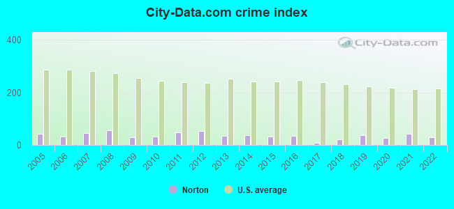
Type |
2009 |
2010 |
2011 |
2012 |
2013 |
2014 |
2015 |
2016 |
2017 |
2018 |
2019 |
2020 |
2021 |
2022 |
|---|---|---|---|---|---|---|---|---|---|---|---|---|---|---|
| Murders (per 100,000) | 0 (0.0) | 0 (0.0) | 0 (0.0) | 0 (0.0) | 0 (0.0) | 0 (0.0) | 0 (0.0) | 1 (5.1) | 0 (0.0) | 0 (0.0) | 0 (0.0) | 0 (0.0) | 0 (0.0) | 0 (0.0) |
| Rapes (per 100,000) | 0 (0.0) | 0 (0.0) | 1 (5.2) | 1 (5.2) | 0 (0.0) | 2 (10.3) | 1 (5.1) | 2 (10.3) | 0 (0.0) | 0 (0.0) | 3 (15.1) | 2 (10.0) | 4 (19.8) | 0 (0.0) |
| Robberies (per 100,000) | 1 (5.1) | 1 (5.3) | 0 (0.0) | 1 (5.2) | 2 (10.3) | 0 (0.0) | 0 (0.0) | 0 (0.0) | 0 (0.0) | 0 (0.0) | 0 (0.0) | 1 (5.0) | 1 (4.9) | 1 (5.2) |
| Assaults (per 100,000) | 3 (15.3) | 2 (10.5) | 6 (31.3) | 7 (36.4) | 6 (30.9) | 2 (10.3) | 14 (71.9) | 7 (36.0) | 1 (5.1) | 14 (70.1) | 20 (100.5) | 15 (75.3) | 21 (103.8) | 20 (103.2) |
| Burglaries (per 100,000) | 35 (178.5) | 39 (204.9) | 55 (287.3) | 70 (364.2) | 36 (185.4) | 26 (133.5) | 17 (87.3) | 16 (82.3) | 12 (61.1) | 6 (30.0) | 7 (35.2) | 1 (5.0) | 1 (4.9) | 2 (10.3) |
| Thefts (per 100,000) | 49 (249.9) | 59 (310.0) | 64 (334.3) | 55 (286.1) | 53 (273.0) | 62 (318.3) | 39 (200.4) | 15 (77.1) | 5 (25.4) | 13 (65.1) | 5 (25.1) | 3 (15.1) | 23 (113.7) | 19 (98.1) |
| Auto thefts (per 100,000) | 4 (20.4) | 4 (21.0) | 7 (36.6) | 4 (20.8) | 1 (5.2) | 8 (41.1) | 2 (10.3) | 2 (10.3) | 1 (5.1) | 4 (20.0) | 1 (5.0) | 0 (0.0) | 1 (4.9) | 8 (41.3) |
| Arson (per 100,000) | 0 (0.0) | 0 (0.0) | 0 (0.0) | 0 (0.0) | 0 (0.0) | 0 (0.0) | 0 (0.0) | 0 (0.0) | 0 (0.0) | 0 (0.0) | 1 (5.0) | 0 (0.0) | 0 (0.0) | 0 (0.0) |
| City-Data.com crime index | 28.7 | 32.1 | 46.8 | 51.6 | 33.6 | 35.6 | 33.4 | 35.4 | 6.7 | 20.3 | 36.0 | 25.5 | 43.3 | 30.1 |
The City-Data.com crime index weighs serious crimes and violent crimes more heavily. Higher means more crime, U.S. average is 246.1. It adjusts for the number of visitors and daily workers commuting into cities.
Crime rate in Norton detailed stats: murders, rapes, robberies, assaults, burglaries, thefts, arson
Full-time law enforcement employees in 2021, including police officers: 34 (33 officers - 29 male; 4 female).
| Officers per 1,000 residents here: | 1.63 |
| Massachusetts average: | 2.53 |
 Recent articles from our blog. Our writers, many of them Ph.D. graduates or candidates, create easy-to-read articles on a wide variety of topics.

 | Towns within 495 with nice walkable downtowns and good schools (205 replies) |
| Police expecting a rough summer ahead, in the city. (2472 replies) |
| 2021 Real Estate Observations (1729 replies) |
| Snowpocalypse on Saturday? (43 replies) |
| Norton, MA - nice place to live? (15 replies) |
| why so much east vs west in such a small state (72 replies) |
Latest news from Norton, MA collected exclusively by city-data.com from local newspapers, TV, and radio stations
Ancestries: Irish (28.6%), English (15.9%), Italian (15.4%), French (9.5%), German (7.7%), Portuguese (6.8%).
Current Local Time: EST time zone
Incorporated in 1711
Elevation: 105 feet
Land area: 28.7 square miles.
Population density: 663 people per square mile (low).
642 residents are foreign born (2.3% Europe, 0.7% Asia).
| This town: | 3.6% |
| Massachusetts: | 12.2% |
| Norton town: | 1.3% ($2,295) |
| Massachusetts: | 1.3% ($2,336) |
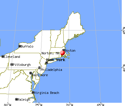
Nearest city with pop. 50,000+: Taunton, MA  (6.6 miles , pop. 55,976).
Nearest city with pop. 200,000+: Boston, MA (24.8 miles , pop. 589,141).
Nearest city with pop. 1,000,000+: Bronx, NY (159.7 miles , pop. 1,332,650).
Nearest cities:
), ), ), Latitude: 41.97 N, Longitude: 71.18 W
Area codes: 508, 774

Norton, Massachusetts accommodation & food services, waste management - Economy and Business Data
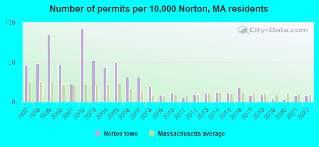
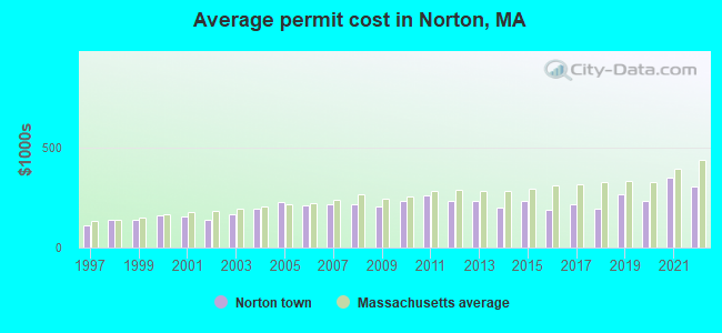
Single-family new house construction building permits:
- 2022: 14 buildings, average cost: $305,800
- 2021: 15 buildings, average cost: $351,300
- 2020: 6 buildings, average cost: $234,100
- 2019: 7 buildings, average cost: $262,500
- 2018: 17 buildings, average cost: $193,500
- 2017: 15 buildings, average cost: $212,800
- 2016: 32 buildings, average cost: $190,100
- 2015: 21 buildings, average cost: $230,700
- 2014: 21 buildings, average cost: $196,500
- 2013: 20 buildings, average cost: $232,300
- 2012: 17 buildings, average cost: $231,600
- 2011: 11 buildings, average cost: $258,300
- 2010: 21 buildings, average cost: $231,900
- 2009: 16 buildings, average cost: $206,200
- 2008: 34 buildings, average cost: $216,000
- 2007: 57 buildings, average cost: $214,800
- 2006: 57 buildings, average cost: $207,800
- 2005: 89 buildings, average cost: $226,300
- 2004: 79 buildings, average cost: $195,300
- 2003: 93 buildings, average cost: $167,200
- 2002: 167 buildings, average cost: $140,300
- 2001: 42 buildings, average cost: $155,300
- 2000: 85 buildings, average cost: $158,900
- 1999: 153 buildings, average cost: $135,600
- 1998: 88 buildings, average cost: $138,900
- 1997: 82 buildings, average cost: $110,200
| Here: | 3.5% |
| Massachusetts: | 3.5% |
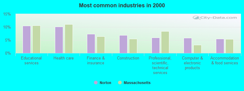
- Educational services (10.5%)
- Health care (10.1%)
- Finance & insurance (7.4%)
- Construction (6.8%)
- Professional, scientific, technical services (6.0%)
- Computer & electronic products (5.8%)
- Accommodation & food services (5.4%)
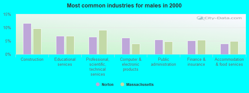
- Construction (11.6%)
- Educational services (6.9%)
- Professional, scientific, technical services (6.5%)
- Computer & electronic products (6.2%)
- Public administration (5.4%)
- Finance & insurance (5.1%)
- Accommodation & food services (4.0%)
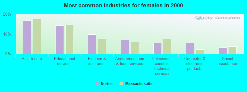
- Health care (16.8%)
- Educational services (14.3%)
- Finance & insurance (9.8%)
- Accommodation & food services (7.0%)
- Professional, scientific, technical services (5.4%)
- Computer & electronic products (5.4%)
- Social assistance (3.1%)
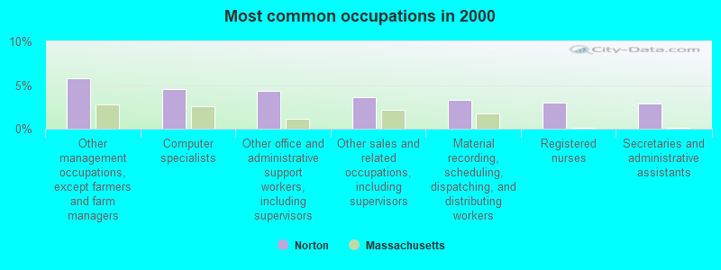
- Other management occupations, except farmers and farm managers (5.8%)
- Computer specialists (4.6%)
- Other office and administrative support workers, including supervisors (4.3%)
- Other sales and related occupations, including supervisors (3.6%)
- Material recording, scheduling, dispatching, and distributing workers (3.3%)
- Registered nurses (2.9%)
- Secretaries and administrative assistants (2.9%)
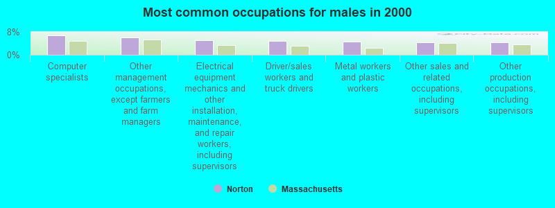
- Computer specialists (6.8%)
- Other management occupations, except farmers and farm managers (6.0%)
- Electrical equipment mechanics and other installation, maintenance, and repair workers, including supervisors (5.1%)
- Driver/sales workers and truck drivers (4.9%)
- Metal workers and plastic workers (4.5%)
- Other sales and related occupations, including supervisors (4.5%)
- Other production occupations, including supervisors (4.3%)

- Other office and administrative support workers, including supervisors (7.5%)
- Secretaries and administrative assistants (6.1%)
- Registered nurses (5.6%)
- Other management occupations, except farmers and farm managers (5.5%)
- Information and record clerks, except customer service representatives (4.5%)
- Customer service representatives (4.5%)
- Preschool, kindergarten, elementary, and middle school teachers (3.5%)
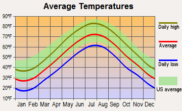
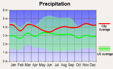
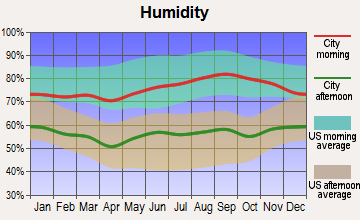
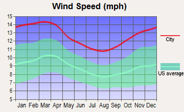
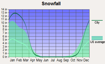
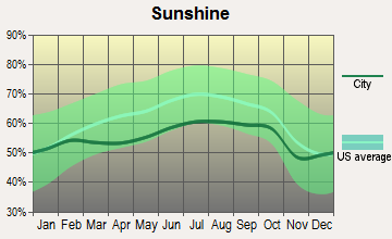
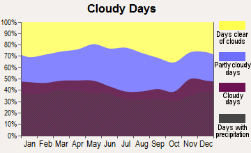
Average climate in Norton, Massachusetts
Based on data reported by over 4,000 weather stations
(lower is better)
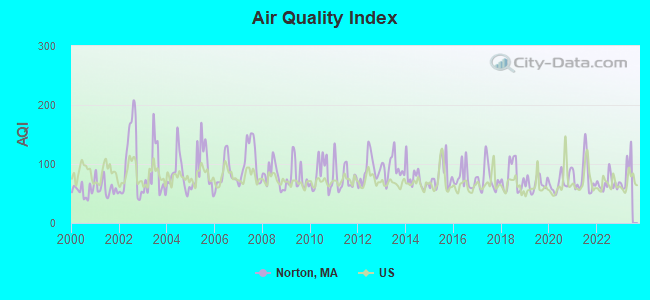
Air Quality Index (AQI) level in 2022 was 67.2. This is about average.
| City: | 67.2 |
| U.S.: | 72.6 |
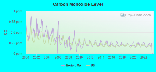
Carbon Monoxide (CO) [ppm] level in 2022 was 0.196. This is better than average. Closest monitor was 12.2 miles away from the city center.
| City: | 0.196 |
| U.S.: | 0.251 |
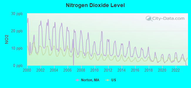
Nitrogen Dioxide (NO2) [ppb] level in 2022 was 3.87. This is better than average. Closest monitor was 5.7 miles away from the city center.
| City: | 3.87 |
| U.S.: | 5.11 |
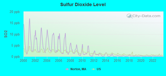
Sulfur Dioxide (SO2) [ppb] level in 2022 was 0.179. This is significantly better than average. Closest monitor was 5.0 miles away from the city center.
| City: | 0.179 |
| U.S.: | 1.515 |

Ozone [ppb] level in 2022 was 30.4. This is about average. Closest monitor was 5.0 miles away from the city center.
| City: | 30.4 |
| U.S.: | 33.3 |
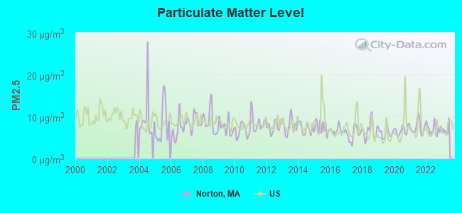
Particulate Matter (PM2.5) [µg/m3] level in 2022 was 6.99. This is about average. Closest monitor was 11.0 miles away from the city center.
| City: | 6.99 |
| U.S.: | 8.11 |
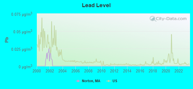
Lead (Pb) [µg/m3] level in 2001 was 0.0151. This is significantly worse than average. Closest monitor was 11.5 miles away from the city center.
| City: | 0.0151 |
| U.S.: | 0.0093 |
Tornado activity:
Norton-area historical tornado activity is slightly below Massachusetts state average. It is 51% smaller than the overall U.S. average.
On 6/9/1953, a category F4 (max. wind speeds 207-260 mph) tornado 28.6 miles away from the Norton town center killed 90 people and injured 1228 people and caused between $50,000,000 and $500,000,000 in damages.
On 6/9/1953, a category F3 (max. wind speeds 158-206 mph) tornado 5.6 miles away from the town center injured 17 people and caused between $500,000 and $5,000,000 in damages.
Earthquake activity:
Norton-area historical earthquake activity is significantly above Massachusetts state average. It is 74% smaller than the overall U.S. average.On 10/7/1983 at 10:18:46, a magnitude 5.3 (5.1 MB, 5.3 LG, 5.1 ML, Class: Moderate, Intensity: VI - VII) earthquake occurred 210.6 miles away from the city center
On 4/20/2002 at 10:50:47, a magnitude 5.3 (5.3 ML, Depth: 3.0 mi) earthquake occurred 216.7 miles away from the city center
On 1/19/1982 at 00:14:42, a magnitude 4.7 (4.5 MB, 4.7 MD, 4.5 LG, Class: Light, Intensity: IV - V) earthquake occurred 107.9 miles away from Norton center
On 4/20/2002 at 10:50:47, a magnitude 5.2 (5.2 MB, 4.2 MS, 5.2 MW, 5.0 MW) earthquake occurred 215.9 miles away from Norton center
On 10/16/2012 at 23:12:25, a magnitude 4.7 (4.7 ML, Depth: 10.0 mi) earthquake occurred 115.7 miles away from the city center
On 8/22/1992 at 12:20:32, a magnitude 4.8 (4.8 MB, 3.8 MS, 4.7 LG, Depth: 6.2 mi) earthquake occurred 203.2 miles away from the city center
Magnitude types: regional Lg-wave magnitude (LG), body-wave magnitude (MB), duration magnitude (MD), local magnitude (ML), surface-wave magnitude (MS), moment magnitude (MW)
Natural disasters:
The number of natural disasters in Bristol County (23) is greater than the US average (15).Major Disasters (Presidential) Declared: 12
Emergencies Declared: 11
Causes of natural disasters: Floods: 8, Hurricanes: 7, Storms: 5, Snows: 3, Snowstorms: 3, Winter Storms: 3, Blizzards: 2, Explosion: 1, Heavy Rain: 1, Snowfall: 1, Tropical Storm: 1, Wind: 1 (Note: some incidents may be assigned to more than one category).

Hospitals and medical centers in Norton:
- COUNTRY HAVEN NURS HME INC (184 MANSFIELD AVE)
- EPOCH SENIOR HEALTHCARE OF NORTON (184 MANSFIELD AVENUE)
Other hospitals and medical centers near Norton:
- MORTON HOME CARE (Home Health Center, about 4 miles away; TAUNTON, MA)
- GOLDEN LIVING CENTER - GARDEN PLACE (Nursing Home, about 4 miles away; ATTLEBORO, MA)
- PLEASANT MANOR NURSING HOME (Nursing Home, about 4 miles away; ATTLEBORO, MA)
- TAUNTON NURSING HOME (Nursing Home, about 5 miles away; TAUNTON, MA)
- LIFE CARE CENTER OF ATTLEBORO (Nursing Home, about 5 miles away; ATTLEBORO, MA)
- GOLDEN LIVING CENTER-ATTLEBORO (Nursing Home, about 6 miles away; ATTLEBORO, MA)
- RIDGEWOOD COURT NURS HOME (Nursing Home, about 6 miles away; ATTLEBORO, MA)
Amtrak stations near Norton:
- 16 miles: PROVIDENCE (100 GASPEE ST.) . Services: ticket office, fully wheelchair accessible, enclosed waiting area, public restrooms, public payphones, snack bar, ATM, paid short-term parking, paid long-term parking, call for car rental service, taxi stand, public transit connection.
- 17 miles: ROUTE 128 (WESTWOOD, UNIVERSITY AVE. & RTE. 128) . Services: ticket office, enclosed waiting area, public restrooms, public payphones, vending machines, paid short-term parking, taxi stand, public transit connection.
College/University in Norton:
Colleges/universities with over 2000 students nearest to Norton:
- Stonehill College (about 9 miles; Easton, MA; Full-time enrollment: 2,563)
- Bridgewater State University (about 12 miles; Bridgewater, MA; FT enrollment: 9,802)
- Massasoit Community College (about 13 miles; Brockton, MA; FT enrollment: 5,442)
- Brown University (about 16 miles; Providence, RI; FT enrollment: 8,458)
- Rhode Island School of Design (about 16 miles; Providence, RI; FT enrollment: 2,714)
- Johnson & Wales University-Providence (about 16 miles; Providence, RI; FT enrollment: 10,898)
- Providence College (about 16 miles; Providence, RI; FT enrollment: 4,312)
Public high school in Norton:
- NORTON HIGH (Students: 724, Location: 66 WEST MAIN STREET, Grades: 9-12)
Private high school in Norton:
Public elementary/middle schools in Norton:
- NORTON MIDDLE (Students: 800, Location: 215 WEST MAIN STREET, Grades: 6-8)
- J C SOLMONESE (Students: 641, Location: 315 WEST MAIN STREET, Grades: KG-3)
- HENRI A. YELLE (Students: 493, Location: 64 WEST MAIN STREET, Grades: 4-5)
- L G NOURSE ELEMENTARY (Students: 388, Location: 38 PLAIN STREET, Grades: PK-3)
Private elementary/middle school in Norton:
Points of interest:
Notable locations in Norton: Camp Finburg (A), Camp Read (B), Norton Fire Department (C), Norton Fire Department Station 5 (D), Norton Fire Department Station 1 (E), Norton Fire Department Station 2 Headquarters (F). Display/hide their locations on the map
Church in Norton: Saint Marys Church (A). Display/hide its location on the map
Cemeteries: Norton Common Cemetery (1), Norton Center Cemetery (2), Babbit Cemetery (3), Newcomb Cemetery (4). Display/hide their locations on the map
Lakes, reservoirs, and swamps: Barrowsville Pond (A), Winnecunnet Pond (B), Chartley Pond (C), Meadow Brook Pond (D), Norton Reservoir (E), Hemlock Swamp (F). Display/hide their locations on the map
Streams, rivers, and creeks: Birch Brook (A), Rumford River (B), Canoe River (C), Chartley Brook (D), Goose Branch (E), Hodges Brook (F), Meadow Brook (G), Wading River (H). Display/hide their locations on the map
Birthplace of: John Jones Clarke - Politician, Richard Henry Hall - Politician, Ronald Conway - College football player (Northeastern Huskies).
Drinking water stations with addresses in Norton and their reported violations in the past:
NORTON WATER DEPARTMENT (Population served: 19,031, Groundwater):Past health violations:
- MCL, Monthly (TCR) - In JUL-2013, Contaminant: Coliform. Follow-up actions: St AO (w/o penalty) issued (NOV-29-2013), St Compliance achieved (NOV-29-2013)
- MCL, Monthly (TCR) - In AUG-2007, Contaminant: Coliform. Follow-up actions: St AO (w/o penalty) issued (DEC-06-2007), St Compliance achieved (DEC-06-2007)
| This town: | 2.7 people |
| Massachusetts: | 2.5 people |
| This town: | 73.0% |
| Whole state: | 63.0% |
| This town: | 6.5% |
| Whole state: | 7.0% |
Likely homosexual households (counted as self-reported same-sex unmarried-partner households)
- Lesbian couples: 0.5% of all households
- Gay men: 0.5% of all households
| This town: | 4.0% |
| Whole state: | 9.3% |
| This town: | 2.1% |
| Whole state: | 4.4% |
People in group quarters in Norton in 2010:
- 1,390 people in college/university student housing
- 249 people in residential treatment centers for adults
- 97 people in nursing facilities/skilled-nursing facilities
- 27 people in group homes intended for adults
- 14 people in group homes for juveniles (non-correctional)
People in group quarters in Norton in 2000:
- 1,374 people in college dormitories (includes college quarters off campus)
- 120 people in nursing homes
- 91 people in homes or halfway houses for drug/alcohol abuse
- 48 people in other noninstitutional group quarters
- 18 people in homes for the mentally retarded
Banks with branches in Norton (2011 data):
- North Easton Savings Bank: Mansfield Avenue Branch at 172 Mansfield Avenue, branch established on 2000/09/25; Norton Branch at 25 West Main Street, branch established on 1975/02/03. Info updated 2009/05/22: Bank assets: $466.2 mil, Deposits: $421.0 mil, headquarters in South Easton, MA, positive income, Mortgage Lending Specialization, 9 total offices
- Mansfield Co-operative Bank: Norton Branch at 225 West Main Street, branch established on 1975/01/01. Info updated 2006/11/03: Bank assets: $358.2 mil, Deposits: $303.5 mil, headquarters in Mansfield, MA, positive income, Commercial Lending Specialization, 5 total offices
- Bank of America, National Association: Norton Branch at 60 West Main Street, branch established on 1953/05/25. Info updated 2009/11/18: Bank assets: $1,451,969.3 mil, Deposits: $1,077,176.8 mil, headquarters in Charlotte, NC, positive income, 5782 total offices, Holding Company: Bank Of America Corporation
For population 15 years and over in Norton:
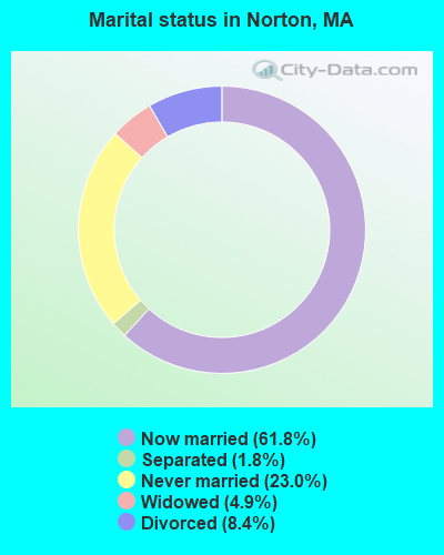
- Never married: 23.0%
- Now married: 61.8%
- Separated: 1.8%
- Widowed: 4.9%
- Divorced: 8.4%
For population 25 years and over in Norton:
- High school or higher: 89.2%
- Bachelor's degree or higher: 30.8%
- Graduate or professional degree: 9.4%
- Unemployed: 12.2%
- Mean travel time to work (commute): 29.8 minutes
| Here: | 10.2 |
| Massachusetts average: | 13.1 |
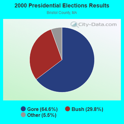
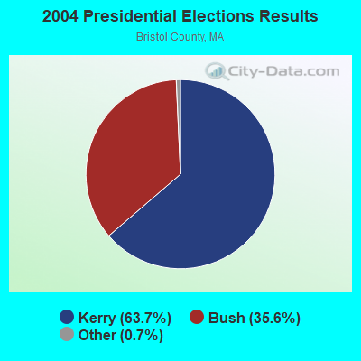
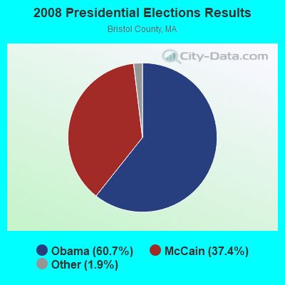
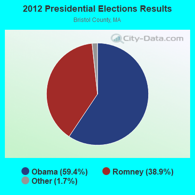
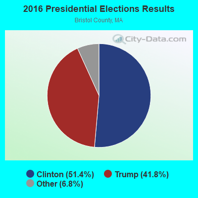
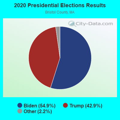
Graphs represent county-level data. Detailed 2008 Election Results
Religion statistics for Norton, MA (based on Bristol County data)
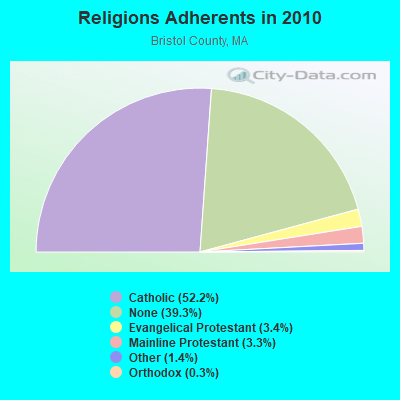
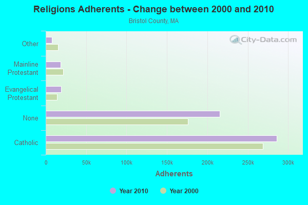
| Religion | Adherents | Congregations |
|---|---|---|
| Catholic | 286,113 | 72 |
| Evangelical Protestant | 18,765 | 128 |
| Mainline Protestant | 18,246 | 83 |
| Other | 7,807 | 33 |
| Orthodox | 1,565 | 4 |
| Black Protestant | 511 | 5 |
| None | 215,278 | - |
Food Environment Statistics:
| Bristol County: | 2.00 / 10,000 pop. |
| Massachusetts: | 1.98 / 10,000 pop. |
| Bristol County: | 0.09 / 10,000 pop. |
| State: | 0.05 / 10,000 pop. |
| Bristol County: | 1.93 / 10,000 pop. |
| Massachusetts: | 2.22 / 10,000 pop. |
| Bristol County: | 2.35 / 10,000 pop. |
| Massachusetts: | 1.77 / 10,000 pop. |
| This county: | 8.20 / 10,000 pop. |
| Massachusetts: | 8.76 / 10,000 pop. |
| Bristol County: | 9.5% |
| Massachusetts: | 8.1% |
| Bristol County: | 26.9% |
| Massachusetts: | 22.5% |
| Bristol County: | 14.4% |
| Massachusetts: | 16.5% |
4.76% of this county's 2021 resident taxpayers lived in other counties in 2020 ($70,162 average adjusted gross income)
| Here: | 4.76% |
| Massachusetts average: | 6.35% |
0.01% of residents moved from foreign countries ($64 average AGI)
Bristol County: 0.01% Massachusetts average: 0.01%
Top counties from which taxpayers relocated into this county between 2020 and 2021:
| from Plymouth County, MA | |
| from Norfolk County, MA | |
| from Providence County, RI |
4.63% of this county's 2020 resident taxpayers moved to other counties in 2021 ($72,404 average adjusted gross income)
| Here: | 4.63% |
| Massachusetts average: | 7.18% |
0.01% of residents moved to foreign countries ($83 average AGI)
Bristol County: 0.01% Massachusetts average: 0.02%
Top counties to which taxpayers relocated from this county between 2020 and 2021:
| to Plymouth County, MA | |
| to Providence County, RI | |
| to Norfolk County, MA |
| Businesses in Norton, MA | ||||
| Name | Count | Name | Count | |
|---|---|---|---|---|
| CVS | 1 | McDonald's | 1 | |
| Dunkin Donuts | 4 | Nike | 1 | |
| Extended Stay America | 1 | Subway | 1 | |
| FedEx | 1 | Walgreens | 1 | |
| MasterBrand Cabinets | 1 | |||
Strongest AM radio stations in Norton:
- WEEI (850 AM; 50 kW; BOSTON, MA; Owner: ENTERCOM BOSTON LICENSE, LLC)
- WALE (990 AM; 50 kW; GREENVILLE, RI; Owner: NORTH AMERICAN BROADCASTING CO., INC.)
- WARL (1320 AM; 5 kW; ATTLEBORO, MA; Owner: THE ADD RADIO GROUP, INC.)
- WBZ (1030 AM; 50 kW; BOSTON, MA; Owner: INFINITY BROADCASTING OPERATIONS, INC.)
- WKOX (1200 AM; 50 kW; FRAMINGHAM, MA; Owner: CAPSTAR TX LIMITED PARTNERSHIP)
- WBIX (1060 AM; 40 kW; NATICK, MA; Owner: LANGER BROADCASTING CORPORATION)
- WDDZ (550 AM; 5 kW; PAWTUCKET, RI; Owner: ABC, INC.)
- WRKO (680 AM; 50 kW; BOSTON, MA; Owner: ENTERCOM BOSTON LICENSE, LLC)
- WAMG (890 AM; 25 kW; DEDHAM, MA; Owner: MEGA COMMUNICATIONS OF DEDHAM LICENSEE, LLC)
- WBET (1460 AM; 5 kW; BROCKTON, MA; Owner: KJI BROADCASTING, LLC)
- WWZN (1510 AM; 50 kW; BOSTON, MA; Owner: ROSE CITY RADIO CORPORATION)
- WSKO (790 AM; 5 kW; PROVIDENCE, RI; Owner: CITADEL BROADCASTING COMPANY)
- WRNI (1290 AM; 10 kW; PROVIDENCE, RI; Owner: WRNI FOUNDATION)
Strongest FM radio stations in Norton:
- WWBB (101.5 FM; PROVIDENCE, RI; Owner: CLEAR CHANNEL BROADCASTING LICENSES, INC.)
- WSNE-FM (93.3 FM; TAUNTON, MA; Owner: CAPSTAR TX LIMITED PARTNERSHIP)
- WBOT (97.7 FM; BROCKTON, MA; Owner: RADIO ONE LICENSES, LLC)
- WBMX (98.5 FM; BOSTON, MA; Owner: INFINITY RADIO OPERATIONS INC.)
- WBOS (92.9 FM; BROOKLINE, MA; Owner: GREATER BOSTON RADIO, INC.)
- WJMN (94.5 FM; BOSTON, MA; Owner: AMFM RADIO LICENSES, L.L.C.)
- WCRB (102.5 FM; WALTHAM, MA; Owner: CHARLES RIVER BROADCASTING WCRB LICE)
- WTKK (96.9 FM; BOSTON, MA; Owner: GREATER BOSTON RADIO, INC.)
- WROR-FM (105.7 FM; FRAMINGHAM, MA; Owner: GREATER BOSTON RADIO, INC.)
- WGBH (89.7 FM; BOSTON, MA; Owner: WGBH EDUCATIONAL FOUNDATION)
- WXKS-FM (107.9 FM; MEDFORD, MA; Owner: AMFM RADIO LICENSES, L.L.C.)
- WBRU (95.5 FM; PROVIDENCE, RI; Owner: BROWN BROADCASTING SERVICE, INC.)
- WBUR-FM (90.9 FM; BOSTON, MA; Owner: TRUSTEES OF BOSTON UNIVERSITY)
- WMJX (106.7 FM; BOSTON, MA; Owner: GREATER BOSTON RADIO, INC.)
- WHJY (94.1 FM; PROVIDENCE, RI; Owner: CAPSTAR TX LIMITED PARTNERSHIP)
- WODS (103.3 FM; BOSTON, MA; Owner: INFINITY BROADCASTING OPERATIONS, INC.)
- WWKX (106.3 FM; WOONSOCKET, RI; Owner: AAA ENTERTAINMENT LICENSING LLC)
- WPRO-FM (92.3 FM; PROVIDENCE, RI; Owner: CITADEL BROADCASTING COMPANY)
- WWLI (105.1 FM; PROVIDENCE, RI; Owner: CITADEL BROADCASTING COMPANY)
- WBCN (104.1 FM; BOSTON, MA; Owner: HEMISPHERE BROADCASTING CORPORATION)
TV broadcast stations around Norton:
- WWDP (Channel 46; NORWELL, MA; Owner: NORWELL TELEVISION, LLC)
- WLNE-TV (Channel 6; NEW BEDFORD, MA; Owner: FREEDOM BROADCASTING OF SOUTHERN NEW ENGLAND, INC.)
- WPRI-TV (Channel 12; PROVIDENCE, RI; Owner: TVL BROADCASTING OF RHODE ISLAND, LLC)
- WNAC-TV (Channel 64; PROVIDENCE, RI; Owner: WNAC, LLC)
- WJAR (Channel 10; PROVIDENCE, RI; Owner: OUTLET BROADCASTING, INC.)
- WSBE-TV (Channel 36; PROVIDENCE, RI; Owner: RHODE ISLAND PUBLIC TELECOM. AUTHORITY)
- WCVB-TV (Channel 5; BOSTON, MA; Owner: WCVB HEARST-ARGYLE TV, INC.)
- WGBH-TV (Channel 2; BOSTON, MA; Owner: WGBH EDUCATIONAL FOUNDATION)
- WHDH-TV (Channel 7; BOSTON, MA; Owner: WHDH-TV)
- WMFP (Channel 62; LAWRENCE, MA; Owner: WSAH LICENSE, INC.)
- WSBK-TV (Channel 38; BOSTON, MA; Owner: VIACOM INC.)
- WLVI-TV (Channel 56; CAMBRIDGE, MA; Owner: WLVI, INC.)
- WBZ-TV (Channel 4; BOSTON, MA; Owner: VIACOM INC.)
- WGBX-TV (Channel 44; BOSTON, MA; Owner: WGBH EDUCATIONAL FOUNDATION)
- WFXT (Channel 25; BOSTON, MA; Owner: FOX TELEVISION STATIONS INC.)
- WLWC (Channel 28; NEW BEDFORD, MA; Owner: C-28 FCC LICENSEE SUBSIDIARY, LLC)
- W40BO (Channel 40; BOSTON, MA; Owner: PAXSON COMMUNICATIONS LPTV, INC.)
- WBPX (Channel 68; BOSTON, MA; Owner: PAXSON BOSTON-68 LICENSE, INC.)
- WUTF (Channel 66; MARLBOROUGH, MA; Owner: TELEFUTURA BOSTON LLC)
- WPXQ (Channel 69; BLOCK ISLAND, RI; Owner: OCEAN STATE TELEVISION, L.L.C.)
- WUNI (Channel 27; WORCESTER, MA; Owner: ENTRAVISION HOLDINGS, LLC)
- WTMU-LP (Channel 32; BOSTON, MA; Owner: ZGS BOSTON, INC.)
- WCEA-LP (Channel 58; BOSTON, MA; Owner: CHANNEL 19 TV CORPORATION)
- WRIW-LP (Channel 50; PROVIDENCE, RI; Owner: ZGS PROVIDENCE, INC.)
- National Bridge Inventory (NBI) Statistics
- 23Number of bridges
- 200ft / 61.1mTotal length
- $49,410,000Total costs
- 308,509Total average daily traffic
- 17,827Total average daily truck traffic
- 501,110Total future (year 2031) average daily traffic
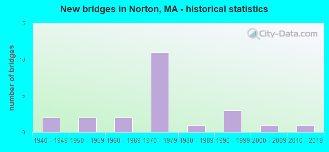
- New bridges - historical statistics
- 21940-1949
- 21950-1959
- 21960-1969
- 111970-1979
- 11980-1989
- 31990-1999
- 12000-2009
- 12010-2019
FCC Registered Cell Phone Towers:
1 (See the full list of FCC Registered Cell Phone Towers in Norton)FCC Registered Antenna Towers:
57 (See the full list of FCC Registered Antenna Towers)FCC Registered Broadcast Land Mobile Towers:
18 (See the full list of FCC Registered Broadcast Land Mobile Towers in Norton, MA)FCC Registered Microwave Towers:
4- NORTON, Rt 123 .25 Mi W Of Int Of Rt 123 & Rt 140 (Lat: 41.965361 Lon: -71.192528), Overall height: 58.8 m, Call Sign: WMR445,
Assigned Frequencies: 10618.1 MHz, Grant Date: 01/11/2011, Expiration Date: 02/01/2021, Cancellation Date: 02/18/2014, Registrant: Verizon Wireless, 1120 Sanctuary Pkwy, #150 Gasa5reg, Alpharetta, GA 30009-7630, Phone: (770) 797-1070, Fax: (770) 797-1036, Email:
- 495 MARKET PLACE, 250 East Main Street (091555) (Lat: 41.987333 Lon: -71.158861), Type: Pole, Structure height: 29.8 m, Overall height: 37.1 m, Call Sign: WQIL284,
Assigned Frequencies: 11565.0 MHz, 6197.24 MHz, Grant Date: 03/07/2008, Expiration Date: 03/07/2018, Cancellation Date: 09/07/2009, Certifier: William Chastain, Registrant: Radio Dynamics Corporation, 774 Mays Blvd., #10-465, Silver Spring, MD 20914, Phone: (301) 493-5171, Fax: (301) 576-4553, Email:
- NORTON WATER, 63 West Main Street (Lat: 41.964861 Lon: -71.193389), Type: Tank, Structure height: 61 m, Overall height: 64.3 m, Call Sign: WRJM299,
Assigned Frequencies: 11155.0 MHz, 11155.0 MHz, 11155.0 MHz, 11155.0 MHz, 11155.0 MHz, 11155.0 MHz, 11155.0 MHz, 11155.0 MHz, 11155.0 MHz, Grant Date: 09/23/2020, Expiration Date: 09/23/2030, Certifier: Robert A Verdone, Registrant: Green Mountain Communications, Inc, 720 Riverwood Dr, Pembroke, NH 03275, Phone: (603) 717-7117, Email:
- NORTON, 308 E Main St (Lat: 41.997028 Lon: -71.153917), Overall height: 59.1 m, Call Sign: WLN548,
Assigned Frequencies: 2178.00 MHz, Grant Date: 03/06/2001, Expiration Date: 02/01/2011, Cancellation Date: 02/26/2008, Certifier: Carol L Tacker, Registrant: Cingular Wireless LLC, 5601 Legacy Drive Ms A-3, Plano, TX 75024, Phone: (469) 229-7506, Fax: (469) 229-7295, Email:
FCC Registered Amateur Radio Licenses:
92 (See the full list of FCC Registered Amateur Radio Licenses in Norton)FAA Registered Aircraft:
9 (See the full list of FAA Registered Aircraft in Norton)2002 - 2018 National Fire Incident Reporting System (NFIRS) incidents
- Fire incident types reported to NFIRS in Norton, MA
- 34640.8%Outside Fires
- 25530.1%Structure Fires
- 13916.4%Mobile Property/Vehicle Fires
- 10812.7%Other
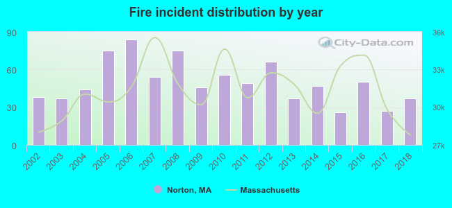 According to the data from the years 2002 - 2018 the average number of fire incidents per year is 50. The highest number of fires - 84 took place in 2006, and the least - 26 in 2015. The data has a declining trend.
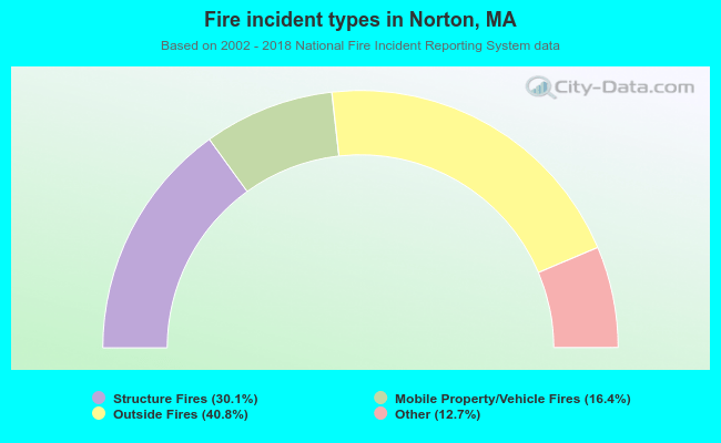 When looking into fire subcategories, the most reports belonged to: Outside Fires (40.8%), and Structure Fires (30.1%).
- 50.1%Utility gas
- 37.6%Fuel oil, kerosene, etc.
- 8.2%Electricity
- 2.2%Bottled, tank, or LP gas
- 1.6%Wood
- 0.2%Solar energy
- 0.1%Other fuel
- 37.8%Electricity
- 34.9%Utility gas
- 25.6%Fuel oil, kerosene, etc.
- 1.6%Bottled, tank, or LP gas
Norton compared to Massachusetts state average:
- Black race population percentage significantly below state average.
- Hispanic race population percentage significantly below state average.
- Foreign-born population percentage significantly below state average.
- Renting percentage significantly below state average.
- Length of stay since moving in significantly above state average.
- Number of rooms per house significantly below state average.
- House age significantly below state average.
Norton on our top lists:
- #23 on the list of "Top 101 cities with largest percentage of females in occupations: other financial specialists (population 5,000+)"
- #44 on the list of "Top 101 cities with largest percentage of females in industries: computer and electronic products (population 5,000+)"
- #50 on the list of "Top 101 cities with the lowest number of thefts per 100,000 residents (population 5,000+)"
- #56 on the list of "Top 101 cities with largest percentage of females in occupations: customer service representatives (population 5,000+)"
- #65 on the list of "Top 101 cities with largest percentage of males in industries: radio, tv, and computer stores (population 5,000+)"
- #73 on the list of "Top 101 cities with largest percentage of females in industries: furniture and home furnishing merchant wholesalers (population 5,000+)"
- #79 on the list of "Top 101 cities with largest percentage of males in industries: management of companies and enterprises (population 5,000+)"
- #81 on the list of "Top 100 safest cities (lowest city-data.com crime index) (pop. 5,000+)"
- #84 on the list of "Top 101 cities with largest percentage of males in occupations: computer specialists (population 5,000+)"
- #93 on the list of "Top 101 cities with largest percentage of females in industries: electrical and electronic goods merchant wholesalers (population 5,000+)"
- #94 on the list of "Top 101 cities with largest percentage of males in industries: computer and electronic products (population 5,000+)"
- #101 on the list of "Top 101 cities with largest percentage of males in occupations: operations specialties managers except financial managers (population 5,000+)"
- #14 on the list of "Top 101 counties with the lowest percentage of residents that keep firearms around their homes"
- #29 on the list of "Top 101 counties with the lowest percentage of residents relocating to foreign countries in 2011 (pop. 50,000+)"
- #32 on the list of "Top 101 counties with the most Catholic congregations"
- #34 on the list of "Top 101 counties with the highest percentage of residents that smoked 100+ cigarettes in their lives"
- #41 on the list of "Top 101 counties with the most Catholic adherents"

|
|
Total of 327 patent applications in 2008-2024.