Norwood, Ohio
Norwood
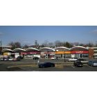
Norwood: Norwood1

Norwood: Norwood

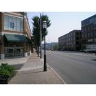
Norwood: norwood2
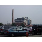
Norwood: norwood3
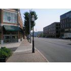
Norwood: norwood1
- add
your
Submit your own pictures of this city and show them to the world
- OSM Map
- General Map
- Google Map
- MSN Map
Population change since 2000: -11.8%
 |
| Males: 9,955 | |
| Females: 9,153 |
| Median resident age: | 33.7 years |
| Ohio median age: | 39.9 years |
Zip codes: 45212.
| Norwood: | $56,928 |
| OH: | $65,720 |
Estimated per capita income in 2022: $36,336 (it was $18,108 in 2000)
Norwood city income, earnings, and wages data
Estimated median house or condo value in 2022: $235,630 (it was $87,600 in 2000)
| Norwood: | $235,630 |
| OH: | $204,100 |
Mean prices in 2022: all housing units: $218,713; detached houses: $223,573; townhouses or other attached units: $192,773; in 2-unit structures: $178,079; in 3-to-4-unit structures: $191,910; mobile homes: $44,134
Median gross rent in 2022: $883.
(16.5% for White Non-Hispanic residents, 23.3% for Black residents, 29.3% for Hispanic or Latino residents, 33.3% for American Indian residents, 100.0% for Native Hawaiian and other Pacific Islander residents, 6.3% for other race residents, 33.9% for two or more races residents)
Detailed information about poverty and poor residents in Norwood, OH


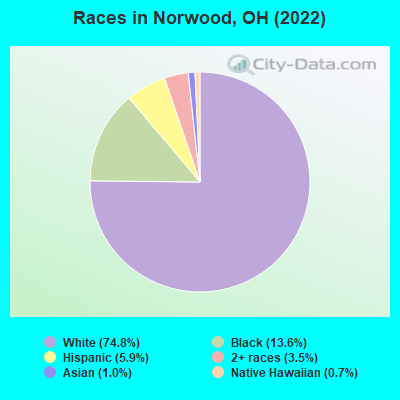
- 14,17474.8%White alone
- 2,57513.6%Black alone
- 1,1235.9%Hispanic
- 6703.5%Two or more races
- 1971.0%Asian alone
- 1260.7%Native Hawaiian and Other
Pacific Islander alone - 160.08%Other race alone
- 80.04%American Indian alone
Races in Norwood detailed stats: ancestries, foreign born residents, place of birth
According to our research of Ohio and other state lists, there were 8 registered sex offenders living in Norwood, Ohio as of April 26, 2024.
The ratio of all residents to sex offenders in Norwood is 2,442 to 1.
The ratio of registered sex offenders to all residents in this city is much lower than the state average.
Type |
2009 |
2010 |
2011 |
2012 |
2013 |
2014 |
2015 |
2016 |
2017 |
2018 |
2019 |
2020 |
2021 |
2022 |
|---|---|---|---|---|---|---|---|---|---|---|---|---|---|---|
| Murders (per 100,000) | 0 (0.0) | 0 (0.0) | 3 (15.6) | 1 (5.2) | 1 (5.2) | 0 (0.0) | 0 (0.0) | 0 (0.0) | 0 (0.0) | 0 (0.0) | 0 (0.0) | 0 (0.0) | 0 (0.0) | 2 (10.8) |
| Rapes (per 100,000) | 8 (39.6) | 12 (62.5) | 3 (15.6) | 9 (47.0) | 7 (36.7) | 8 (42.0) | 9 (46.2) | 12 (59.8) | 15 (75.0) | 12 (60.1) | 12 (60.2) | 12 (60.5) | 4 (20.3) | 9 (48.4) |
| Robberies (per 100,000) | 67 (331.6) | 83 (432.1) | 58 (301.8) | 43 (224.4) | 42 (220.4) | 44 (231.3) | 56 (287.8) | 28 (139.5) | 28 (140.0) | 21 (105.1) | 21 (105.4) | 17 (85.7) | 13 (65.8) | 8 (43.0) |
| Assaults (per 100,000) | 12 (59.4) | 17 (88.5) | 11 (57.2) | 11 (57.4) | 20 (105.0) | 22 (115.6) | 23 (118.2) | 12 (59.8) | 25 (125.0) | 26 (130.2) | 22 (110.4) | 19 (95.8) | 30 (151.9) | 35 (188.2) |
| Burglaries (per 100,000) | 254 (1,257) | 292 (1,520) | 282 (1,467) | 286 (1,493) | 300 (1,575) | 222 (1,167) | 189 (971.2) | 167 (832.3) | 132 (660.2) | 110 (550.7) | 80 (401.6) | 94 (473.7) | 47 (238.0) | 61 (327.9) |
| Thefts (per 100,000) | 908 (4,493) | 960 (4,998) | 1,079 (5,614) | 1,028 (5,366) | 932 (4,892) | 957 (5,030) | 880 (4,522) | 801 (3,992) | 708 (3,541) | 601 (3,009) | 474 (2,379) | 422 (2,127) | 377 (1,909) | 439 (2,360) |
| Auto thefts (per 100,000) | 71 (351.4) | 39 (203.1) | 49 (254.9) | 26 (135.7) | 40 (210.0) | 53 (278.6) | 49 (251.8) | 49 (244.2) | 56 (280.1) | 38 (190.2) | 30 (150.6) | 43 (216.7) | 18 (91.1) | 31 (166.6) |
| Arson (per 100,000) | 0 (0.0) | 0 (0.0) | 3 (15.6) | 2 (10.4) | 3 (15.7) | 4 (21.0) | 2 (10.3) | 2 (10.0) | 2 (10.0) | 1 (5.0) | 1 (5.0) | 1 (5.0) | 1 (5.1) | 4 (21.5) |
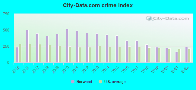
| City-Data.com crime index | 438.9 | 519.9 | 493.3 | 456.8 | 449.7 | 431.3 | 416.0 | 339.1 | 337.3 | 279.7 | 237.2 | 228.8 | 166.6 | 241.4 |
The City-Data.com crime index weighs serious crimes and violent crimes more heavily. Higher means more crime, U.S. average is 246.1. It adjusts for the number of visitors and daily workers commuting into cities.
Crime rate in Norwood detailed stats: murders, rapes, robberies, assaults, burglaries, thefts, arson
Full-time law enforcement employees in 2011, including police officers: 51 (48 officers - 47 male; 1 female).
| Officers per 1,000 residents here: | 2.50 |
| Ohio average: | 2.11 |
 Recent articles from our blog. Our writers, many of them Ph.D. graduates or candidates, create easy-to-read articles on a wide variety of topics.

 | Will Columbus become largest Ohio metro? (887 replies) |
| Air and Water Quality, Norwood (2 replies) |
| Management and Budget Woes in Norwood (5 replies) |
| Is Norwood safe, near Highland Ave & Montgomery Rd?? ( Cincinnati ) (2 replies) |
| Norwood gains a major new employer (5 replies) |
| Oxford to Norwood and in between... (23 replies) |
Latest news from Norwood, OH collected exclusively by city-data.com from local newspapers, TV, and radio stations
Ancestries: German (24.6%), American (9.6%), Irish (6.0%), English (6.0%), Italian (4.3%), European (2.3%).
Current Local Time: EST time zone
Land area: 3.12 square miles.
Population density: 6,133 people per square mile (high).
871 residents are foreign born (1.7% Latin America, 1.2% Asia, 0.8% Oceania, 0.6% Europe).
| This city: | 4.6% |
| Ohio: | 4.9% |
Median real estate property taxes paid for housing units with mortgages in 2022: $3,072 (1.2%)
Median real estate property taxes paid for housing units with no mortgage in 2022: $2,607 (1.4%)
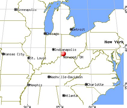
Nearest city with pop. 50,000+: Cincinnati, OH  (3.1 miles , pop. 331,285).
Nearest city with pop. 1,000,000+: Chicago, IL (251.2 miles , pop. 2,896,016).
Nearest cities:
), ), ), ), )Latitude: 39.16 N, Longitude: 84.46 W
Daytime population change due to commuting: +1,649 (+8.7%)
Workers who live and work in this city: 2,576 (24.0%)
Area code commonly used in this area: 513
Norwood, Ohio accommodation & food services, waste management - Economy and Business Data
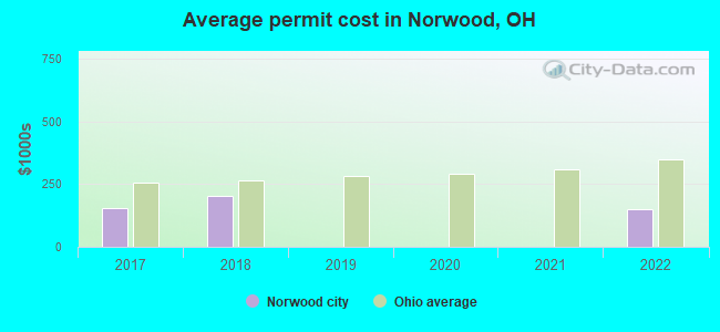
Single-family new house construction building permits:
- 2022: 1 building, cost: $150,000
- 2018: 3 buildings, average cost: $201,700
- 2017: 1 building, cost: $155,000
| Here: | 2.8% |
| Ohio: | 3.1% |
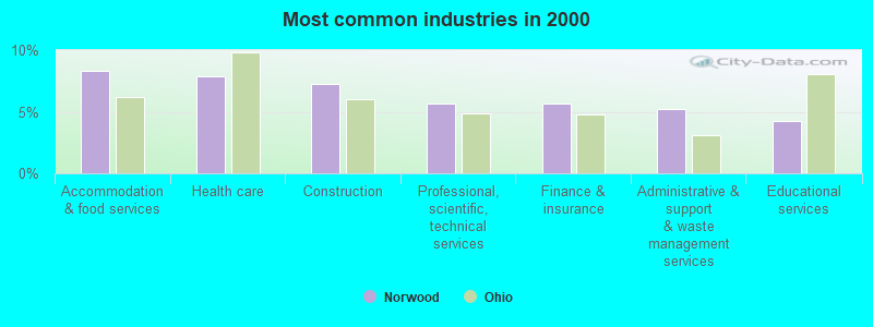
- Accommodation & food services (8.3%)
- Health care (7.9%)
- Construction (7.3%)
- Professional, scientific, technical services (5.7%)
- Finance & insurance (5.6%)
- Administrative & support & waste management services (5.2%)
- Educational services (4.2%)
- Construction (12.9%)
- Accommodation & food services (6.1%)
- Administrative & support & waste management services (5.9%)
- Professional, scientific, technical services (5.3%)
- Public administration (4.4%)
- Educational services (3.2%)
- Transportation equipment (2.9%)
- Health care (14.2%)
- Accommodation & food services (10.8%)
- Finance & insurance (8.9%)
- Professional, scientific, technical services (6.1%)
- Educational services (5.4%)
- Administrative & support & waste management services (4.4%)
- Social assistance (3.4%)
- Other production occupations, including supervisors (5.2%)
- Other office and administrative support workers, including supervisors (4.4%)
- Other sales and related occupations, including supervisors (4.2%)
- Building and grounds cleaning and maintenance occupations (3.3%)
- Information and record clerks, except customer service representatives (3.2%)
- Material recording, scheduling, dispatching, and distributing workers (3.0%)
- Laborers and material movers, hand (3.0%)
- Other production occupations, including supervisors (6.9%)
- Driver/sales workers and truck drivers (5.5%)
- Electrical equipment mechanics and other installation, maintenance, and repair workers, including supervisors (3.8%)
- Laborers and material movers, hand (3.6%)
- Building and grounds cleaning and maintenance occupations (3.5%)
- Other management occupations, except farmers and farm managers (3.4%)
- Material recording, scheduling, dispatching, and distributing workers (3.3%)

- Other office and administrative support workers, including supervisors (6.9%)
- Other sales and related occupations, including supervisors (5.6%)
- Information and record clerks, except customer service representatives (4.6%)
- Secretaries and administrative assistants (4.2%)
- Cashiers (4.2%)
- Other production occupations, including supervisors (3.4%)
- Retail sales workers, except cashiers (3.3%)
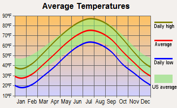
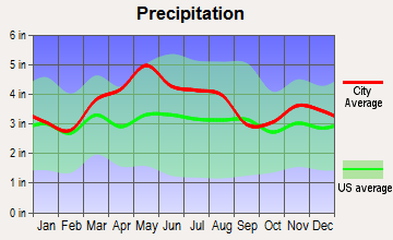
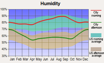
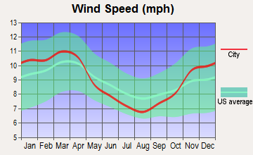
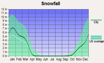
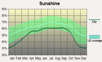
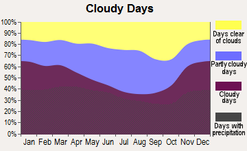
Average climate in Norwood, Ohio
Based on data reported by over 4,000 weather stations
|
|

(lower is better)
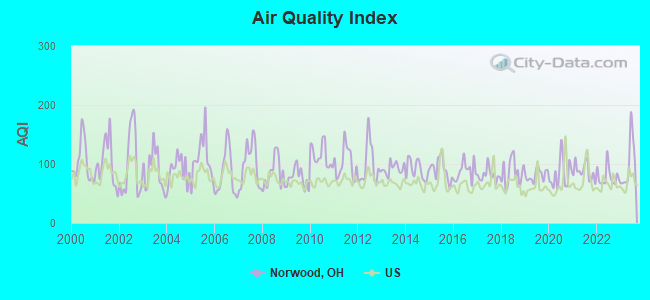
Air Quality Index (AQI) level in 2023 was 101. This is worse than average.
| City: | 101 |
| U.S.: | 73 |
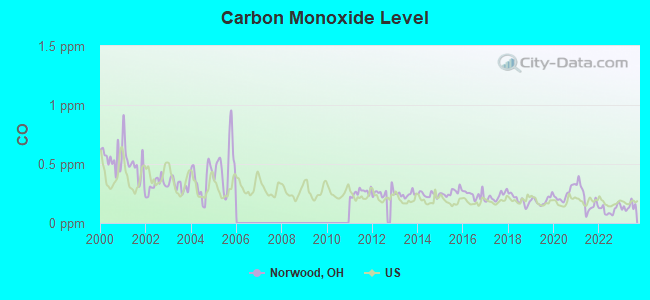
Carbon Monoxide (CO) [ppm] level in 2023 was 0.138. This is significantly better than average. Closest monitor was 0.9 miles away from the city center.
| City: | 0.138 |
| U.S.: | 0.251 |
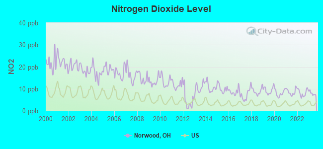
Nitrogen Dioxide (NO2) [ppb] level in 2023 was 7.93. This is significantly worse than average. Closest monitor was 0.9 miles away from the city center.
| City: | 7.93 |
| U.S.: | 5.11 |
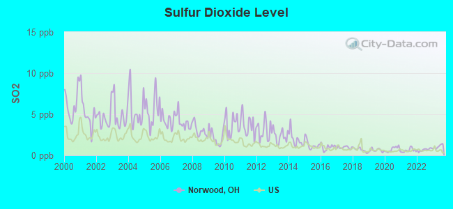
Sulfur Dioxide (SO2) [ppb] level in 2023 was 1.08. This is significantly better than average. Closest monitor was 2.4 miles away from the city center.
| City: | 1.08 |
| U.S.: | 1.51 |
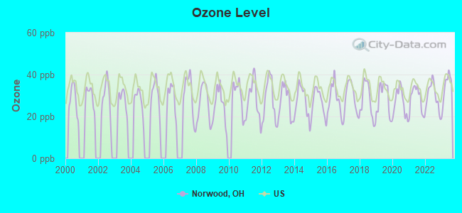
Ozone [ppb] level in 2023 was 34.2. This is about average. Closest monitor was 3.3 miles away from the city center.
| City: | 34.2 |
| U.S.: | 33.3 |
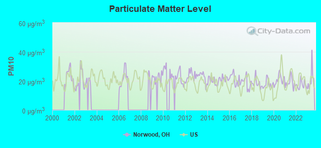
Particulate Matter (PM10) [µg/m3] level in 2023 was 21.0. This is about average. Closest monitor was 3.4 miles away from the city center.
| City: | 21.0 |
| U.S.: | 19.2 |
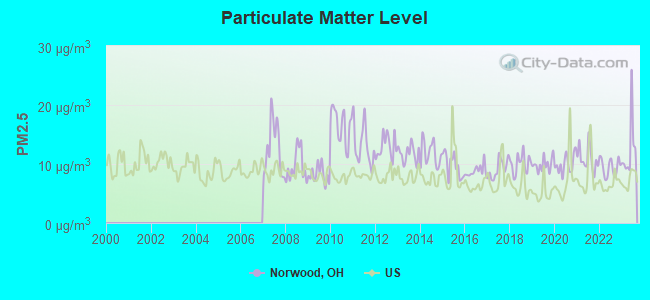
Particulate Matter (PM2.5) [µg/m3] level in 2023 was 12.5. This is significantly worse than average. Closest monitor was 0.2 miles away from the city center.
| City: | 12.5 |
| U.S.: | 8.1 |
Tornado activity:
Norwood-area historical tornado activity is slightly above Ohio state average. It is 64% greater than the overall U.S. average.
On 4/3/1974, a category F5 (max. wind speeds 261-318 mph) tornado 10.3 miles away from the Norwood city center killed 3 people and injured 210 people.
On 4/3/1974, a category F4 (max. wind speeds 207-260 mph) tornado 1.9 miles away from the city center killed 2 people and injured 39 people and caused between $50,000 and $500,000 in damages.
Earthquake activity:
Norwood-area historical earthquake activity is significantly above Ohio state average. It is 46% greater than the overall U.S. average.On 7/27/1980 at 18:52:21, a magnitude 5.2 (5.1 MB, 4.7 MS, 5.0 UK, 5.2 UK, Class: Moderate, Intensity: VI - VII) earthquake occurred 71.6 miles away from Norwood center
On 4/18/2008 at 09:36:59, a magnitude 5.4 (5.1 MB, 4.8 MS, 5.4 MW, 5.2 MW) earthquake occurred 191.3 miles away from Norwood center
On 4/18/2008 at 09:36:59, a magnitude 5.2 (5.2 MW, Depth: 8.9 mi) earthquake occurred 191.3 miles away from Norwood center
On 9/7/1988 at 02:28:09, a magnitude 4.6 (4.5 MB, 4.6 LG, Class: Light, Intensity: IV - V) earthquake occurred 76.9 miles away from the city center
On 6/10/1987 at 23:48:54, a magnitude 5.1 (4.9 MB, 4.4 MS, 4.6 MS, 5.1 LG) earthquake occurred 185.9 miles away from the city center
On 7/12/1986 at 08:19:37, a magnitude 4.5 (4.5 MB) earthquake occurred 95.3 miles away from Norwood center
Magnitude types: regional Lg-wave magnitude (LG), body-wave magnitude (MB), surface-wave magnitude (MS), moment magnitude (MW)
Natural disasters:
The number of natural disasters in Hamilton County (15) is near the US average (15).Major Disasters (Presidential) Declared: 10
Emergencies Declared: 3
Causes of natural disasters: Floods: 7, Storms: 7, Mudslides: 2, Tornadoes: 2, Blizzard: 1, Heavy Rain: 1, Hurricane: 1, Landslide: 1, Snow: 1, Snowstorm: 1, Tropical Depression: 1, Wind: 1, Other: 1 (Note: some incidents may be assigned to more than one category).

Hospitals and medical centers in Norwood:
Other hospitals and medical centers near Norwood:
- PINNACLE SENIOR CARE (Home Health Center, about 1 miles away; CINCINNATI, OH)
- DAVITA - NORWOOD DIALYSIS (Dialysis Facility, about 1 miles away; CINCINNATI, OH)
- AMERICAN MERCY HOME CARE, LLC (Home Health Center, about 1 miles away; CINCINNATI, OH)
- FIRST CHOICE HOME HEALTH OHIO, INC (Home Health Center, about 1 miles away; CINCINNATI, OH)
- HEARTLAND HOME HEALTH CARE AND H (Home Health Center, about 1 miles away; CINCINNATI, OH)
- US RENAL CARE OF NORWOOD DIALYSIS (Dialysis Facility, about 1 miles away; CINCINNATI, OH)
- VICTORIA RETIREMENT COMMUNITY (Nursing Home, about 1 miles away; CINCINNATI, OH)
Amtrak stations near Norwood:
- 6 miles: CINCINNATI (1301 WESTERN AVE.) . Services: ticket office, fully wheelchair accessible, enclosed waiting area, public restrooms, public payphones, full-service food facilities, free short-term parking, paid long-term parking, taxi stand.
- 18 miles: HAMILTON (M. L. KING BLVD AT HENRY ST.) . Services: public payphones, free short-term parking, call for taxi service, public transit connection.
Colleges/Universities in Norwood:
Colleges/universities with over 2000 students nearest to Norwood:
- Xavier University (about 2 miles; Cincinnati, OH; Full-time enrollment: 6,143)
- University of Cincinnati-Main Campus (about 4 miles; Cincinnati, OH; FT enrollment: 28,747)
- Cincinnati State Technical and Community College (about 5 miles; Cincinnati, OH; FT enrollment: 8,757)
- University of Cincinnati-Blue Ash College (about 6 miles; Blue Ash, OH; FT enrollment: 3,711)
- Northern Kentucky University (about 10 miles; Highland Heights, KY; FT enrollment: 12,059)
- College of Mount St Joseph (about 11 miles; Cincinnati, OH; FT enrollment: 2,073)
- University of Cincinnati-Clermont College (about 16 miles; Batavia, OH; FT enrollment: 2,739)
Public high schools in Norwood:
- NORWOOD HIGH SCHOOL (Students: 666, Location: 2020 SHERMAN AVE, Grades: 9-12)
- NORWOOD CONVERSION COMMUNITY SCHOOL (Location: 2132 WILLIAMS AVE, Grades: 7-12, Charter school)
Private high school in Norwood:
Public elementary/middle schools in Norwood:
- NORWOOD VIEW ELEMENTARY SCHOOL (Students: 395, Location: 5328 CARTHAGE AVE, Grades: KG-6)
- WILLIAMS AVENUE ELEMENTARY SCHOOL (Students: 355, Location: 2132 WILLIAMS AVE, Grades: PK-6)
- NORWOOD MIDDLE SCHOOL (Students: 320, Location: 2060 SHERMAN AVE, Grades: 7-8)
- SHARPSBURG ELEMENTARY SCHOOL (Students: 247, Location: 4400 SMITH RD, Grades: 2-6)
- SHARPSBURG PRIMARY (Students: 209, Location: 4321 FOREST AVE, Grades: PK-2)
User-submitted facts and corrections:
- The Pauline Warfield Lewis Center is now known as Summit Behavioral Healthcare Center (hospitals and medical centers)--it is a psychiatric hospital
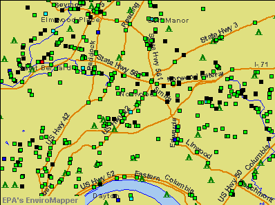
Points of interest:
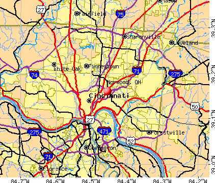
Notable locations in Norwood: Norwood Industrial Park (A), Norwood Waterworks (B), Norwood Municipal Building (C), Norwood Fire Department (D), Norwood Public Library (E). Display/hide their locations on the map
Shopping Centers: Hunters Plaza Shopping Center (1), Norwood Plaza Shopping Center (2), Surrey Square Mall Shopping Center (3). Display/hide their locations on the map
Churches in Norwood include: New Bethel Baptist Church (A), Liberty Baptist Church (B), Trinity Pentecostal Church (C), Swifton Chapel Church of God (D), Norwood Presbyterian Church (E), Norwood First United Methodist Church (F), Norwood Church of God (G), Norwood Baptist Church (H), New Testament Baptist Church (I). Display/hide their locations on the map
Parks in Norwood include: Burwood Playground (1), Tower Park (2), Dar Field (3), Waterworks Park (4), Victory Park (5), Millcrest Park (6), Marsh Avenue Park (7), Dorl Field (8), Hunter Park (9). Display/hide their locations on the map
Birthplace of: Dorothy Kamenshek - Baseball player, Frank Bradway Rogers - Librarian, Janice Rule - Actress, Bob Wellman - Baseabll player, George Chakiris - (born 1934), actor, Vera-Ellen - (died 1981), actress, Arthur Pickens - Jockey, Bob Barton - Baseball player, Ed Klieman - Baseball player, Larry Pape - MLB pitcher.
| This city: | 2.3 people |
| Ohio: | 2.4 people |
| This city: | 50.4% |
| Whole state: | 65.0% |
| This city: | 9.2% |
| Whole state: | 6.8% |
Likely homosexual households (counted as self-reported same-sex unmarried-partner households)
- Lesbian couples: 0.3% of all households
- Gay men: 0.3% of all households
People in group quarters in Norwood in 2010:
- 136 people in nursing facilities/skilled-nursing facilities
- 67 people in emergency and transitional shelters (with sleeping facilities) for people experiencing homelessness
- 13 people in group homes intended for adults
- 9 people in group homes for juveniles (non-correctional)
- 2 people in other noninstitutional facilities
People in group quarters in Norwood in 2000:
- 109 people in other noninstitutional group quarters
- 77 people in nursing homes
- 34 people in college dormitories (includes college quarters off campus)
- 8 people in homes for the mentally retarded
Banks with branches in Norwood (2011 data):
- Foundation Bank: Norwood Branch at 4730 Montgomery Road, branch established on 1887/01/01. Info updated 2011/07/21: Bank assets: $201.8 mil, Deposits: $141.7 mil, headquarters in Cincinnati, OH, positive income, Commercial Lending Specialization, 5 total offices
- The Huntington National Bank: Linden Pointe Branch at 4803 Montgomery Road, branch established on 2008/03/24. Info updated 2012/04/02: Bank assets: $54,183.4 mil, Deposits: $44,300.3 mil, headquarters in Columbus, OH, positive income, Commercial Lending Specialization, 878 total offices, Holding Company: Huntington Bancshares Incorporated
For population 15 years and over in Norwood:
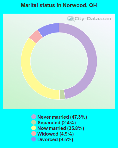
- Never married: 47.3%
- Now married: 35.8%
- Separated: 2.4%
- Widowed: 4.9%
- Divorced: 9.5%
For population 25 years and over in Norwood:
- High school or higher: 89.8%
- Bachelor's degree or higher: 34.9%
- Graduate or professional degree: 12.9%
- Unemployed: 5.1%
- Mean travel time to work (commute): 18.6 minutes
| Here: | 11.7 |
| Ohio average: | 11.0 |
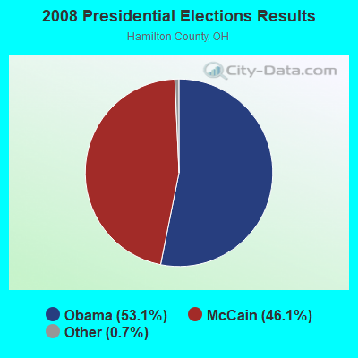
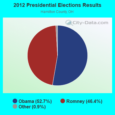
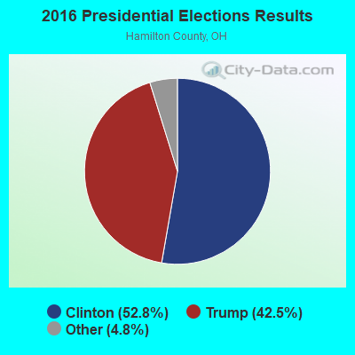
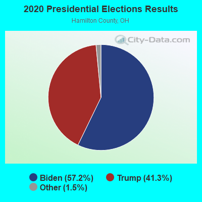
Graphs represent county-level data. Detailed 2008 Election Results
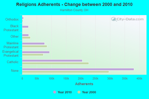
Religion statistics for Norwood, OH (based on Hamilton County data)
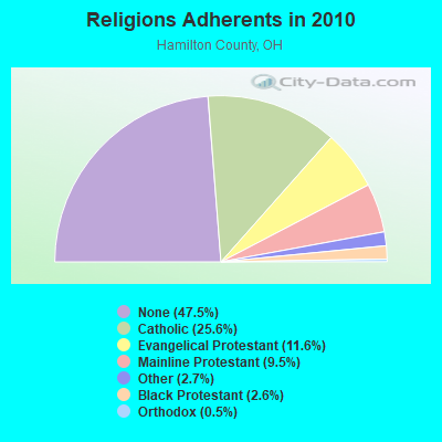
| Religion | Adherents | Congregations |
|---|---|---|
| Catholic | 205,094 | 83 |
| Evangelical Protestant | 93,166 | 269 |
| Mainline Protestant | 76,354 | 188 |
| Other | 21,699 | 64 |
| Black Protestant | 20,814 | 55 |
| Orthodox | 3,879 | 7 |
| None | 381,368 | - |
Food Environment Statistics:
| This county: | 1.82 / 10,000 pop. |
| Ohio: | 1.89 / 10,000 pop. |
| Hamilton County: | 0.12 / 10,000 pop. |
| Ohio: | 0.13 / 10,000 pop. |
| Hamilton County: | 1.49 / 10,000 pop. |
| State: | 1.25 / 10,000 pop. |
| Here: | 2.66 / 10,000 pop. |
| State: | 2.93 / 10,000 pop. |
| Here: | 7.48 / 10,000 pop. |
| Ohio: | 6.25 / 10,000 pop. |
| This county: | 9.8% |
| State: | 10.3% |
| Here: | 26.6% |
| Ohio: | 29.1% |
| Here: | 11.7% |
| Ohio: | 11.9% |
Health and Nutrition:
| Norwood: | 49.0% |
| State: | 50.4% |
| This city: | 46.1% |
| State: | 47.8% |
| Norwood: | 28.9 |
| Ohio: | 28.7 |
| Norwood: | 21.0% |
| State: | 20.6% |
| This city: | 10.9% |
| Ohio: | 10.4% |
| Here: | 6.8 |
| Ohio: | 6.8 |
| Norwood: | 33.9% |
| Ohio: | 34.3% |
| Norwood: | 56.9% |
| Ohio: | 57.0% |
| This city: | 78.9% |
| Ohio: | 79.1% |
More about Health and Nutrition of Norwood, OH Residents
| Local government employment and payroll (March 2022) | |||||
| Function | Full-time employees | Monthly full-time payroll | Average yearly full-time wage | Part-time employees | Monthly part-time payroll |
|---|---|---|---|---|---|
| Police Protection - Officers | 54 | $391,612 | $87,025 | 3 | $4,225 |
| Firefighters | 52 | $358,798 | $82,800 | 0 | $0 |
| Streets and Highways | 19 | $93,551 | $59,085 | 0 | $0 |
| Financial Administration | 13 | $44,081 | $40,690 | 0 | $0 |
| Other Government Administration | 11 | $49,660 | $54,175 | 19 | $22,771 |
| Other and Unallocable | 9 | $37,434 | $49,912 | 0 | $0 |
| Health | 7 | $29,490 | $50,554 | 0 | $0 |
| Judicial and Legal | 5 | $14,934 | $35,842 | 0 | $0 |
| Police - Other | 3 | $13,115 | $52,460 | 0 | $0 |
| Fire - Other | 2 | $9,909 | $59,454 | 0 | $0 |
| Totals for Government | 175 | $1,042,584 | $71,491 | 22 | $26,997 |
Norwood government finances - Expenditure in 2021 (per resident):
- Current Operations - General - Other: $10,863,000 ($568.51)
Toll Highways: $757,000 ($39.62)
Solid Waste Management: $410,000 ($21.46)
Water Utilities: $308,000 ($16.12)
Local Fire Protection: $250,000 ($13.08)
Police Protection: $215,000 ($11.25)
Parks and Recreation: $104,000 ($5.44)
Judicial and Legal Services: $69,000 ($3.61)
Financial Administration: $16,000 ($0.84)
Norwood government finances - Revenue in 2021 (per resident):
- Charges - Sewerage: $5,550,000 ($290.45)
Solid Waste Management: $1,642,000 ($85.93)
Parks and Recreation: $61,000 ($3.19)
- Local Intergovernmental - General Local Government Support: $4,349,000 ($227.60)
Highways: $853,000 ($44.64)
- Revenue - Water Utilities: $4,565,000 ($238.91)
- State Intergovernmental - General Local Government Support: $1,805,000 ($94.46)
- Tax - Property: $18,863,000 ($987.18)
Individual Income: $2,902,000 ($151.87)
Corporation Net Income: $376,000 ($19.68)
Occupation and Business License - Other: $13,000 ($0.68)
Alcoholic Beverage License: $7,000 ($0.37)
Amusements Sales: $2,000 ($0.10)
Tobacco Products Sales: $1,000 ($0.05)
Norwood government finances - Debt in 2021 (per resident):
- Long Term Debt - Outstanding Unspecified Public Purpose: $5,993,000 ($313.64)
Beginning Outstanding - Unspecified Public Purpose: $5,766,000 ($301.76)
Beginning Outstanding - Public Debt for Private Purpose: $2,291,000 ($119.90)
Outstanding Nonguaranteed - Industrial Revenue: $2,243,000 ($117.39)
Issue, Unspecified Public Purpose: $937,000 ($49.04)
Retired Unspecified Public Purpose: $710,000 ($37.16)
Retired Nonguaranteed - Public Debt for Private Purpose: $48,000 ($2.51)
- Short Term Debt Outstanding - End of Fiscal Year: $2,537,000 ($132.77)
Beginning: $2,372,000 ($124.14)
Norwood government finances - Cash and Securities in 2021 (per resident):
- Bond Funds - Cash and Securities: $227,000 ($11.88)
- Other Funds - Cash and Securities: $1,539,000 ($80.54)
- Sinking Funds - Cash and Securities: $2,243,000 ($117.39)
5.24% of this county's 2021 resident taxpayers lived in other counties in 2020 ($68,039 average adjusted gross income)
| Here: | 5.24% |
| Ohio average: | 5.68% |
0.01% of residents moved from foreign countries ($43 average AGI)
Hamilton County: 0.01% Ohio average: 0.01%
Top counties from which taxpayers relocated into this county between 2020 and 2021:
| from Butler County, OH | |
| from Clermont County, OH | |
| from Warren County, OH |
6.26% of this county's 2020 resident taxpayers moved to other counties in 2021 ($83,260 average adjusted gross income)
| Here: | 6.26% |
| Ohio average: | 5.79% |
0.01% of residents moved to foreign countries ($86 average AGI)
Hamilton County: 0.01% Ohio average: 0.01%
Top counties to which taxpayers relocated from this county between 2020 and 2021:
| to Butler County, OH | |
| to Clermont County, OH | |
| to Warren County, OH |
| Businesses in Norwood, OH | ||||
| Name | Count | Name | Count | |
|---|---|---|---|---|
| Arby's | 1 | McDonald's | 1 | |
| AutoZone | 1 | Nike | 1 | |
| CVS | 1 | Payless | 1 | |
| Chico's | 1 | Penske | 1 | |
| Cricket Wireless | 1 | Popeyes | 1 | |
| Decora Cabinetry | 2 | Shoe Carnival | 1 | |
| Domino's Pizza | 1 | T.J.Maxx | 1 | |
| FedEx | 1 | Taco Bell | 1 | |
| H&R Block | 1 | Victoria's Secret | 1 | |
| KFC | 1 | Wendy's | 1 | |
| Marshalls | 1 | White Castle | 1 | |
| MasterBrand Cabinets | 2 | |||
Strongest AM radio stations in Norwood:
- WLW (700 AM; 50 kW; CINCINNATI, OH; Owner: JACOR BROADCASTING CORPORATION)
- WSAI (1530 AM; 50 kW; CINCINNATI, OH; Owner: JACOR BROADCASTING CORPORATION)
- WCIN (1480 AM; 5 kW; CINCINNATI, OH)
- WKRC (550 AM; 5 kW; CINCINNATI, OH; Owner: JACOR BROADCASTING CORPORATION)
- WCKY (1360 AM; 5 kW; CINCINNATI, OH; Owner: JACOR BROADCASTING CORPORATION)
- WDBZ (1230 AM; 1 kW; CINCINNATI, OH; Owner: BLUE CHIP COMMUNICATIONS, INC.)
- WTSJ (1050 AM; 1 kW; CINCINNATI, OH; Owner: CARON BROADCASTING, INC.)
- WCNW (1560 AM; daytime; 5 kW; FAIRFIELD, OH)
- WNOP (740 AM; 1 kW; NEWPORT, KY; Owner: SACRED HEART RADIO, INC.)
- WBOB (1160 AM; 5 kW; FLORENCE, KY; Owner: CARON BROADCASTING, INC.)
- WTVN (610 AM; 50 kW; COLUMBUS, OH; Owner: CITICASTERS LICENSES, L.P.)
- WHAS (840 AM; 50 kW; LOUISVILLE, KY; Owner: CLEAR CHANNEL BROADCASTING LICENSES, INC.)
- WCVG (1320 AM; 0 kW; COVINGTON, KY; Owner: RICHARD L. PLESSINGER SR.)
Strongest FM radio stations in Norwood:
- WUBE-FM (105.1 FM; CINCINNATI, OH; Owner: INFINITY RADIO OPERATIONS INC.)
- WKRQ (101.9 FM; CINCINNATI, OH; Owner: INFINITY RADIO OPERATIONS INC.)
- WKFS (107.1 FM; MILFORD, OH; Owner: JACOR BROADCASTING CORPORATION)
- WGRR (103.5 FM; HAMILTON, OH; Owner: INFINITY RADIO OPERATIONS INC.)
- WVXU (91.7 FM; CINCINNATI, OH; Owner: XAVIER UNIVERSITY)
- WGUC (90.9 FM; CINCINNATI, OH; Owner: CINCINNATI CLASSICAL PUBLIC RADIO, INC.)
- WRRM (98.5 FM; CINCINNATI, OH; Owner: WRRM LICO, INC)
- WAIF (88.3 FM; CINCINNATI, OH; Owner: STEPCHILD RADIO OF CINCINNATI, INC.)
- WOFX-FM (92.5 FM; CINCINNATI, OH; Owner: JACOR BROADCASTING CORPORATION)
- WVMX (94.1 FM; CINCINNATI, OH; Owner: CITICASTERS LICENSES, L.P.)
- WEBN (102.7 FM; CINCINNATI, OH; Owner: JACOR BROADCASTING CORPORATION)
- WMOJ (94.9 FM; FAIRFIELD, OH; Owner: WVAE LICO, INC.)
- WAKW (93.3 FM; CINCINNATI, OH; Owner: PILLAR OF FIRE)
- WIZF (100.9 FM; ERLANGER, KY; Owner: BLUE CHIP BROADCASTING LICENSES II, LTD.)
- WMKV (89.3 FM; READING, OH; Owner: LIFESPHERE)
- WYGY (96.5 FM; LEBANON, OH; Owner: WVAE LICO, INC.)
- WNKU (89.7 FM; HIGHLAND HEIGHTS, KY; Owner: BD. OF REGENTS ON N. KY UNIV.)
- WLHS (89.9 FM; WEST CHESTER, OH; Owner: LAKOTA LOCAL SCHOOL DISTRICT)
- WAQZ (97.3 FM; FORT THOMAS, KY; Owner: INFINITY RADIO OPERATIONS INC.)
- WOBO (88.7 FM; BATAVIA, OH; Owner: WCNE EDUCATIONAL COMMUNITY RADIO,INC)
TV broadcast stations around Norwood:
- WCPO-TV (Channel 9; CINCINNATI, OH; Owner: SCRIPPS HOWARD BROADCASTING COMPANY)
- WLWT (Channel 5; CINCINNATI, OH; Owner: OHIO/OKLAHOMA HEARST-ARGYLE TV, INC)
- WKRC-TV (Channel 12; CINCINNATI, OH; Owner: CITICASTERS CO.)
- WBQC-CA (Channel 25; CINCINNATI, OH; Owner: ELLIOTT B. BLOCK)
- WOTH-LP (Channel 35; CINCINNATI, OH; Owner: ELLIOTT B. BLOCK)
- WSTR-TV (Channel 64; CINCINNATI, OH; Owner: WSTR LICENSEE, INC.)
- WCET (Channel 48; CINCINNATI, OH; Owner: THE GREATER CINCINNATI TV EDUC'L. FOUNDATION)
- WXIX-TV (Channel 19; NEWPORT, KY; Owner: RAYCOM NATIONAL, INC.)
- WCVN-TV (Channel 54; COVINGTON, KY; Owner: KENTUCKY AUTHORITY FOR EDUCATIONAL TV)
- WKOI (Channel 43; RICHMOND, IN; Owner: TRINITY BROADCASTING OF INDIANA, INC.)
- WPTO (Channel 14; OXFORD, OH; Owner: GREATER DAYTON PUBLIC TELEVISION, INC.)
- WHIO-TV (Channel 7; DAYTON, OH; Owner: WHIO-TV HOLDINGS, INC.)
- WDTN (Channel 2; DAYTON, OH; Owner: WDTN BROADCASTING, LLC)
- WPTD (Channel 16; DAYTON, OH; Owner: GREATER DAYTON PUBLIC TV, INC.)
- WKEF (Channel 22; DAYTON, OH; Owner: WKEF LICENSEE L.P.)
- WRGT-TV (Channel 45; DAYTON, OH; Owner: WRGT LICENSEE, LLC)
- National Bridge Inventory (NBI) Statistics
- 26Number of bridges
- 331ft / 101mTotal length
- $156,000Total costs
- 955,797Total average daily traffic
- 93,422Total average daily truck traffic
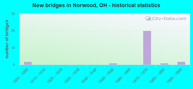
- New bridges - historical statistics
- 21900-1909
- 11950-1959
- 201970-1979
- 11980-1989
- 21990-1999
FCC Registered Antenna Towers:
87 (See the full list of FCC Registered Antenna Towers in Norwood)FCC Registered Broadcast Land Mobile Towers:
7- Montgomery Rd & Elm St (Lat: 39.162000 Lon: -84.455778), Call Sign: KQK570,
Assigned Frequencies: 460.575 MHz, 460.575 MHz, Grant Date: 08/29/2012, Expiration Date: 11/10/2022, Cancellation Date: 01/14/2023, Registrant: Norwood Fire Dept, 4725 Montgomery Rd, Norwood, OH 45212, Phone: (513) 458-4568, Fax: (513) 458-4551, Email:
- Water Tower 2413 Indian Mound Ave (Lat: 39.168389 Lon: -84.446611), Call Sign: KVA429, Licensee ID: L00061183,
Assigned Frequencies: 453.725 MHz, Grant Date: 02/19/2004, Expiration Date: 02/22/2014, Cancellation Date: 04/26/2014, Registrant: City Of Norwood, 4645 Montgomery Rd, Norwood, OH 45212, Phone: (513) 458-4615
- 2020 Sherman Ave (Lat: 39.161444 Lon: -84.458556), Type: Building, Structure height: 9 m, Overall height: 12 m, Call Sign: WPIA317,
Assigned Frequencies: 451.162 MHz, 464.775 MHz, Grant Date: 07/13/2015, Expiration Date: 08/17/2025, Certifier: Douglas J Lantz, Registrant: Mobilcomm, 1211 W Sharon Rd, Cincinnati, OH 45240, Phone: (513) 595-5800
- Lat: 39.166222 Lon: -84.450556, Call Sign: WPMV668,
Assigned Frequencies: 451.487 MHz, 451.687 MHz, Grant Date: 01/20/2024, Expiration Date: 01/29/2034, Certifier: Donald F Rabe, Registrant: Mobilcomm Inc, 1211 W Sharon Rd, Cincinnati, OH 45240-2916, Phone: (513) 595-5800, Fax: (513) 595-5919, Email:
- Lat: 39.160556 Lon: -84.446111, Call Sign: WQJV775,
Assigned Frequencies: 451.612 MHz, 456.612 MHz, 452.812 MHz, 457.812 MHz, Grant Date: 01/15/2009, Expiration Date: 01/15/2019, Cancellation Date: 02/06/2017, Certifier: Barry Hamilton, Registrant: Siemens Corporation, 100 Technology Drive, Alpharetta, GA 30005, Phone: (770) 751-2163, Email:
- HERITAGE HILL APTS., Lat: 39.172806 Lon: -84.447972, Call Sign: WQQT200, Licensee ID: L01502812,
Assigned Frequencies: 451.187 MHz, Grant Date: 01/12/2023, Expiration Date: 02/26/2033, Certifier: Jack Graudenz, Registrant: Cereniti Datasense Networks, 41 East Washington Street, Suite 110, Indianapolis, IN 46204, Phone: (877) 237-3648, Fax: (877) 362-6640, Email:
- Lat: 39.149861 Lon: -84.443583, Call Sign: WQSI412,
Assigned Frequencies: 72.1800 MHz, Grant Date: 09/24/2013, Expiration Date: 09/24/2023, Cancellation Date: 11/25/2023, Certifier: Sam Cordray, Registrant: Primex Wireless, Inc., 965 Wells Street, Lake Geneva, WI 53147, Phone: (800) 537-0464
FCC Registered Microwave Towers:
2- NORWOOD, 3823 Montgomery Rd (Lat: 39.149528 Lon: -84.469000), Type: Tower, Structure height: 46.6 m, Overall height: 49.1 m, Call Sign: WLW540,
Assigned Frequencies: 6790.00 MHz, Grant Date: 01/25/2011, Expiration Date: 02/01/2021, Cancellation Date: 03/01/2011, Registrant: Verizon Wireless, 1120 Sanctuary Pkwy, #150 Gasa5reg, Alpharetta, GA 30009-7630, Phone: (770) 797-1070, Fax: (770) 797-1036, Email:
- Norwood, 3001 Harris Ave (Lat: 39.160833 Lon: -84.441389), Type: Tower, Structure height: 57 m, Overall height: 60 m, Call Sign: WQBQ707,
Assigned Frequencies: 10715.0 MHz, 10835.0 MHz, 10715.0 MHz, 10835.0 MHz, 10715.0 MHz, 10835.0 MHz, 10715.0 MHz, 10835.0 MHz, 10715.0 MHz, 10835.0 MHz... (+36 more), Grant Date: 08/28/2014, Expiration Date: 11/23/2024, Certifier: Jack Johnson, Registrant: Micronet Communications, Inc., 812 Lexington Dr, Plano, TX 75075, Phone: (972) 422-7200, Email:
FCC Registered Paging Towers:
1- 6015 Winton Rd ` (Lat: 39.200333 Lon: -84.522694), Overall height: 290.8 m, Call Sign: KNKS257,
Assigned Frequencies: 931.387 MHz, Expiration Date: 03/09/2005, Cancellation Date: 03/09/2005, Registrant: O\'Connor And Hannan, L.L.P., 1919 Pennsylvania Ave. Nw, Washington, DC 20006-3483, Phone: (202) 887-1431
FCC Registered Amateur Radio Licenses:
30 (See the full list of FCC Registered Amateur Radio Licenses in Norwood)FAA Registered Aircraft:
7- Aircraft: GLOBE GC-1B (Category: Land, Seats: 2, Weight: Up to 12,499 Pounds, Speed: 105 mph), Engine: CONT MOTOR C125 SERIES (125 HP) (Reciprocating)
N-Number: 3321K, N3321K, N-3321K, Serial Number: 1314, Year manufactured: 1946, Airworthiness Date: 04/01/1957, Certificate Issue Date: 11/17/2018
Registrant (Individual): Christopher R Reiff, 1920 Mills Ave, Norwood, OH 45212 - Aircraft: LEARJET INC 60 (Category: Land, Engines: 2, Seats: 11, Weight: Up to 12,499 Pounds), Engine: P & W PW300 SER (5200 Pounds of Thrust) (Turbo-fan)
N-Number: 960SC, N960SC, N-960SC, Serial Number: 106, Year manufactured: 1997, Airworthiness Date: 07/03/1997, Certificate Issue Date: 08/02/2017
Registrant (LLC): Jet Air LLC, 4900 Beech St, Norwood, OH 45212 - Aircraft: DJI INSPIRE 1 (Category: Land, Engines: 4), Engine: Electric
N-Number: 980TV, N980TV, N-980TV, Serial Number: W13DCD25030440, Certificate Issue Date: 06/08/2015
Registrant (Individual): Thomas T Vonahlefeld, 1725 Cleneay Ave Apt 2223, Norwood, OH 45212
Deregistered: Cancel Date: 01/08/2019 - Aircraft: DJI INSPIRE 1 (Category: Land, Engines: 4), Engine: Electric
N-Number: 981TV, N981TV, N-981TV, Serial Number: W13DCD25030051, Certificate Issue Date: 06/08/2015
Registrant (Individual): Thomas T Vonahlefeld, 1725 Cleneay Ave Apt 2223, Norwood, OH 45212
Deregistered: Cancel Date: 01/08/2019 - Aircraft: LEARJET INC 60 (Category: Land, Engines: 2, Seats: 11, Weight: Up to 12,499 Pounds), Engine: P & W PW300 SER (5200 Pounds of Thrust) (Turbo-fan)
N-Number: 945G, N945G, N-945G, Serial Number: 106, Year manufactured: 1997, Airworthiness Date: 07/03/1997, Certificate Issue Date: 08/02/2017
Registrant (Corporation): Jet Air LLC, 4900 Beech St, Norwood, OH 45212 - Aircraft: THURMAN BENTON B MINI 500 (Category: Land, Weight: Up to 12,499 Pounds), Engine: BOMBARDIER ROTAX (ALL) (Reciprocating)
N-Number: 2345J, N2345J, N-2345J, Serial Number: 0238, Year manufactured: 1997, Airworthiness Date: 02/03/1997, Certificate Issue Date: 08/16/1997
Registrant (Individual): Benton B Thurman, 3827 Hazel Ave, Norwood, OH 45212
Deregistered: Cancel Date: 06/30/2017 - Aircraft: ENGINEERING & RESEARCH 415-C (Category: Land, Seats: 2, Weight: Up to 12,499 Pounds, Speed: 90 mph), Engine: CONT MOTOR A&C75 SERIES (75 HP) (Reciprocating)
N-Number: 93970, N93970, N-93970, Serial Number: 1293, Year manufactured: 1946
Registrant (Individual): Fred W Patterson, 2224 Lawn Ave, Norwood, OH 45212
Deregistered: Cancel Date: 11/21/2017
2002 - 2018 National Fire Incident Reporting System (NFIRS) incidents
- Fire incident types reported to NFIRS in Norwood, OH
- 69641.0%Outside Fires
- 67439.7%Structure Fires
- 31518.6%Mobile Property/Vehicle Fires
- 110.6%Other
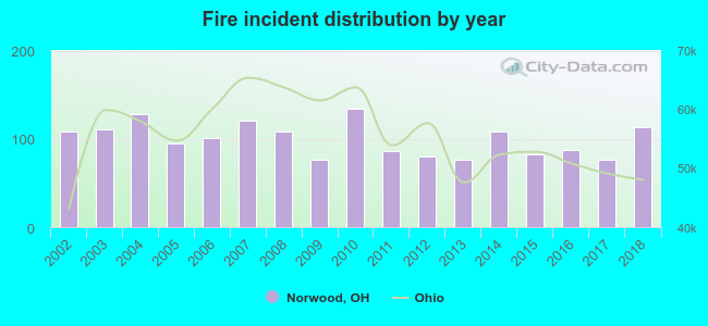 Based on the data from the years 2002 - 2018 the average number of fire incidents per year is 100. The highest number of fire incidents - 134 took place in 2010, and the least - 76 in 2013. The data has a growing trend.
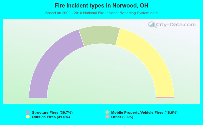 When looking into fire subcategories, the most reports belonged to: Outside Fires (41.0%), and Structure Fires (39.7%).
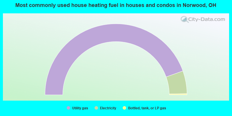
- 89.1%Utility gas
- 10.4%Electricity
- 0.5%Bottled, tank, or LP gas
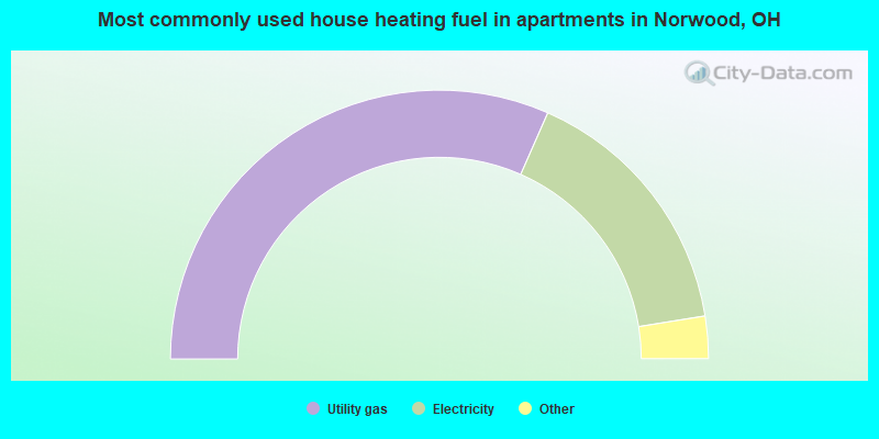
- 63.2%Utility gas
- 31.7%Electricity
- 2.1%Bottled, tank, or LP gas
- 1.4%Other fuel
- 1.1%No fuel used
- 0.3%Fuel oil, kerosene, etc.
- 0.2%Coal or coke
Norwood compared to Ohio state average:
- Unemployed percentage below state average.
- Median age below state average.
- Renting percentage above state average.
- House age above state average.
- Percentage of population with a bachelor's degree or higher above state average.
Norwood on our top lists:
- #2 on the list of "Top 100 cities with oldest houses (pop. 5,000+)"
- #56 on the list of "Top 100 cities with old houses but young residents"
- #92 on the list of "Top 101 cities with largest percentage of males in occupations: office and administrative support occupations (population 5,000+)"
- #9 on the list of "Top 101 counties with the highest number of infant deaths per 1000 residents 2007-2013 (pop. 50,000+)"
- #13 on the list of "Top 101 counties with the highest Sulfur Oxides Annual air pollution readings in 2012 (µg/m3)"
- #22 on the list of "Top 101 counties with the most Catholic congregations"
- #25 on the list of "Top 101 counties with the most Mainline Protestant congregations"
- #32 on the list of "Top 101 counties with the most Mainline Protestant adherents (pop. 50,000+)"

|
|
Total of 54 patent applications in 2008-2024.