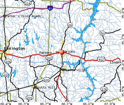
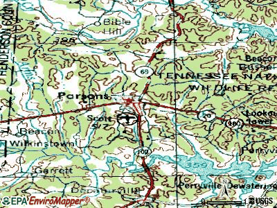
Parsons, Tennessee
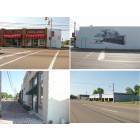
Parsons: Main Street and Tennessee Avenue
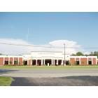
Parsons: Parsons Municipal Building
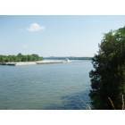
Parsons: Tennessee River at Perryville, TN (5 Miles East of Parsons)
- add
your
Submit your own pictures of this city and show them to the world
- OSM Map
- General Map
- Google Map
- MSN Map
Population change since 2000: -13.8%
 |
| Males: 1,067 | |
| Females: 1,047 |
| Median resident age: | 42.2 years |
| Tennessee median age: | 39.2 years |
Zip codes: 38363.
| Parsons: | $39,742 |
| TN: | $65,254 |
Estimated per capita income in 2022: $24,362 (it was $18,077 in 2000)
Parsons city income, earnings, and wages data
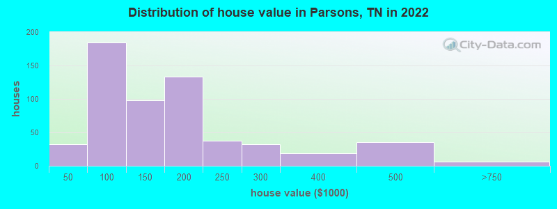
Estimated median house or condo value in 2022: $144,057 (it was $54,900 in 2000)
| Parsons: | $144,057 |
| TN: | $284,800 |
Mean prices in 2022: all housing units: $169,958; detached houses: $177,520; mobile homes: $85,931
Median gross rent in 2022: $714.
(22.6% for White Non-Hispanic residents, 28.9% for Black residents, 49.0% for two or more races residents)
Detailed information about poverty and poor residents in Parsons, TN


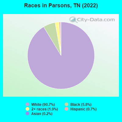
- 2,26590.7%White alone
- 1455.8%Black alone
- 471.9%Two or more races
- 180.7%Hispanic
- 60.2%Asian alone
Races in Parsons detailed stats: ancestries, foreign born residents, place of birth
According to our research of Tennessee and other state lists, there were 23 registered sex offenders living in Parsons, Tennessee as of April 27, 2024.
The ratio of all residents to sex offenders in Parsons is 115 to 1.
Type |
2009 |
2010 |
2011 |
2012 |
2013 |
2014 |
2015 |
2016 |
2017 |
2018 |
2019 |
2020 |
2021 |
2022 |
|---|---|---|---|---|---|---|---|---|---|---|---|---|---|---|
| Murders (per 100,000) | 0 (0.0) | 0 (0.0) | 0 (0.0) | 0 (0.0) | 0 (0.0) | 0 (0.0) | 0 (0.0) | 0 (0.0) | 0 (0.0) | 0 (0.0) | 0 (0.0) | 0 (0.0) | 0 (0.0) | 0 (0.0) |
| Rapes (per 100,000) | 0 (0.0) | 0 (0.0) | 0 (0.0) | 0 (0.0) | 0 (0.0) | 1 (42.6) | 0 (0.0) | 2 (85.8) | 3 (127.4) | 2 (86.4) | 0 (0.0) | 0 (0.0) | 1 (44.2) | 0 (0.0) |
| Robberies (per 100,000) | 0 (0.0) | 0 (0.0) | 0 (0.0) | 0 (0.0) | 1 (42.7) | 0 (0.0) | 0 (0.0) | 0 (0.0) | 0 (0.0) | 0 (0.0) | 0 (0.0) | 0 (0.0) | 0 (0.0) | 0 (0.0) |
| Assaults (per 100,000) | 2 (85.5) | 6 (252.8) | 6 (250.6) | 5 (210.3) | 3 (128.0) | 4 (170.6) | 2 (85.6) | 7 (300.3) | 12 (509.6) | 7 (302.2) | 5 (217.0) | 5 (219.0) | 6 (265.0) | 3 (144.6) |
| Burglaries (per 100,000) | 12 (513.3) | 9 (379.3) | 9 (375.9) | 11 (462.6) | 9 (384.1) | 13 (554.4) | 14 (599.3) | 9 (386.1) | 9 (382.2) | 8 (345.4) | 3 (130.2) | 4 (175.2) | 1 (44.2) | 6 (289.3) |
| Thefts (per 100,000) | 31 (1,326) | 26 (1,096) | 29 (1,211) | 31 (1,304) | 19 (810.9) | 27 (1,151) | 22 (941.8) | 37 (1,587) | 23 (976.6) | 24 (1,036) | 16 (694.4) | 6 (262.8) | 17 (750.9) | 21 (1,013) |
| Auto thefts (per 100,000) | 0 (0.0) | 0 (0.0) | 2 (83.5) | 3 (126.2) | 2 (85.4) | 2 (85.3) | 5 (214.0) | 4 (171.6) | 3 (127.4) | 3 (129.5) | 11 (477.4) | 3 (131.4) | 2 (88.3) | 2 (96.4) |
| Arson (per 100,000) | 0 (0.0) | 0 (0.0) | 0 (0.0) | 0 (0.0) | 0 (0.0) | 0 (0.0) | 0 (0.0) | 0 (0.0) | 0 (0.0) | 0 (0.0) | 0 (0.0) | 1 (43.8) | 0 (0.0) | 0 (0.0) |
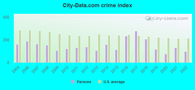
| City-Data.com crime index | 106.1 | 120.9 | 131.6 | 136.7 | 104.6 | 159.9 | 113.9 | 232.9 | 279.8 | 205.5 | 118.5 | 77.1 | 128.5 | 97.4 |
The City-Data.com crime index weighs serious crimes and violent crimes more heavily. Higher means more crime, U.S. average is 246.1. It adjusts for the number of visitors and daily workers commuting into cities.
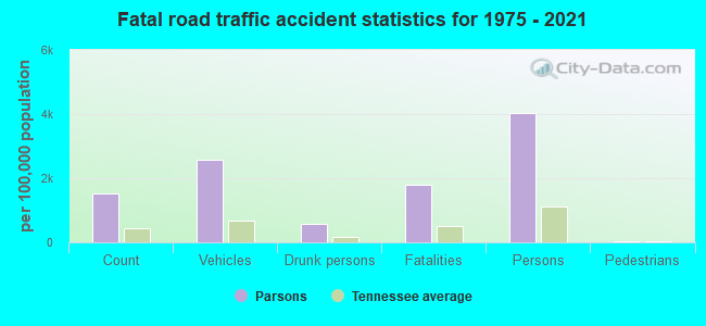
Crime rate in Parsons detailed stats: murders, rapes, robberies, assaults, burglaries, thefts, arson
Full-time law enforcement employees in 2021, including police officers: 7 (7 officers - 6 male; 1 female).
| Officers per 1,000 residents here: | 3.09 |
| Tennessee average: | 2.57 |
 Recent articles from our blog. Our writers, many of them Ph.D. graduates or candidates, create easy-to-read articles on a wide variety of topics.

 | Tennessee's 2020 Census results (70 replies) |
| Month long road trip -(Dec-Jan) . (12 replies) |
| Driving thru TN in a few weeks. (18 replies) |
| Searching for small town in TN to retire (19 replies) |
| What is Nashville like for people who hate country music? (32 replies) |
| Is it just me, or does Memphis have sandy soil? (9 replies) |
Latest news from Parsons, TN collected exclusively by city-data.com from local newspapers, TV, and radio stations
Ancestries: American (35.0%), Irish (13.8%), English (13.6%), German (6.3%), Norwegian (2.2%), European (2.1%).
Current Local Time: CST time zone
Incorporated in 1913
Elevation: 497 feet
Land area: 3.91 square miles.
Population density: 541 people per square mile (low).
6 residents are foreign born
| This city: | 0.2% |
| Tennessee: | 5.4% |
Median real estate property taxes paid for housing units with mortgages in 2022: $749 (0.5%)
Median real estate property taxes paid for housing units with no mortgage in 2022: $573 (0.4%)
Nearest city with pop. 50,000+: Jackson, TN  (39.2 miles , pop. 59,643).
Nearest city with pop. 200,000+: Metropolitan Government, TN (83.8 miles , pop. 569,891).
Nearest city with pop. 1,000,000+: Chicago, IL (428.9 miles , pop. 2,896,016).
Nearest cities:
), ), Latitude: 35.65 N, Longitude: 88.12 W
Area code: 731
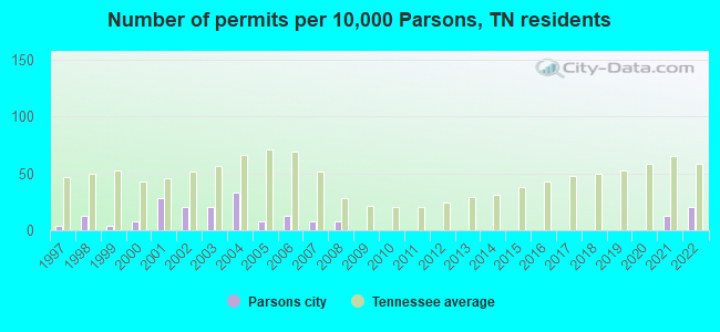
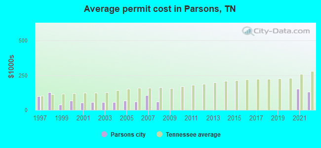
Single-family new house construction building permits:
- 2022: 5 buildings, average cost: $131,600
- 2021: 3 buildings, average cost: $153,000
- 2008: 2 buildings, average cost: $60,000
- 2007: 2 buildings, average cost: $106,400
- 2006: 3 buildings, average cost: $60,600
- 2005: 2 buildings, average cost: $69,000
- 2004: 8 buildings, average cost: $55,600
- 2003: 5 buildings, average cost: $56,500
- 2002: 5 buildings, average cost: $56,500
- 2001: 7 buildings, average cost: $52,100
- 2000: 2 buildings, average cost: $69,000
- 1999: 1 building, cost: $39,700
- 1998: 3 buildings, average cost: $128,300
- 1997: 1 building, cost: $100,000
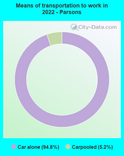
| Here: | 4.0% |
| Tennessee: | 3.0% |
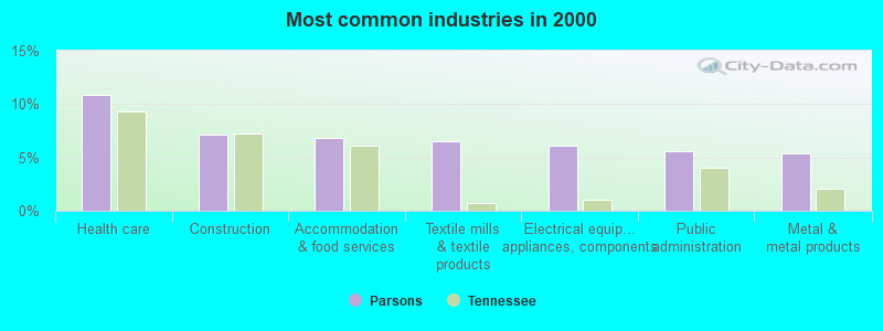
- Health care (10.9%)
- Construction (7.2%)
- Accommodation & food services (6.9%)
- Textile mills & textile products (6.5%)
- Electrical equipment, appliances, components (6.1%)
- Public administration (5.5%)
- Metal & metal products (5.3%)
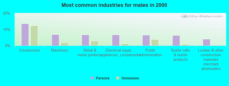
- Construction (13.6%)
- Machinery (7.0%)
- Metal & metal products (6.8%)
- Electrical equipment, appliances, components (6.8%)
- Public administration (6.6%)
- Textile mills & textile products (6.4%)
- Lumber & other construction materials merchant wholesalers (4.1%)
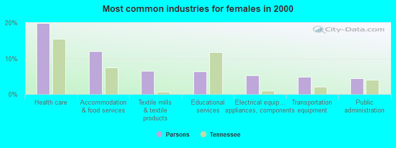
- Health care (19.8%)
- Accommodation & food services (12.0%)
- Textile mills & textile products (6.5%)
- Educational services (6.3%)
- Electrical equipment, appliances, components (5.2%)
- Transportation equipment (4.8%)
- Public administration (4.4%)
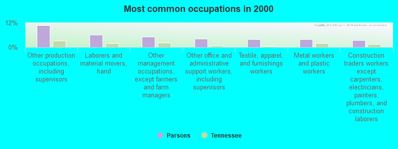
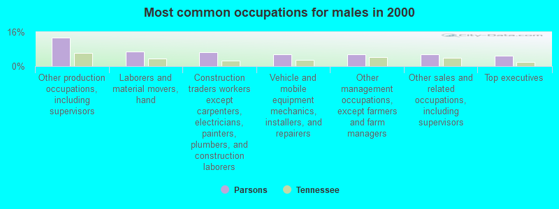
- Other production occupations, including supervisors (10.7%)
- Laborers and material movers, hand (6.2%)
- Other management occupations, except farmers and farm managers (5.1%)
- Other office and administrative support workers, including supervisors (4.1%)
- Textile, apparel, and furnishings workers (4.0%)
- Metal workers and plastic workers (3.8%)
- Construction traders workers except carpenters, electricians, painters, plumbers, and construction laborers (3.4%)
- Other production occupations, including supervisors (13.4%)
- Laborers and material movers, hand (7.0%)
- Construction traders workers except carpenters, electricians, painters, plumbers, and construction laborers (6.4%)
- Vehicle and mobile equipment mechanics, installers, and repairers (5.6%)
- Other management occupations, except farmers and farm managers (5.6%)
- Other sales and related occupations, including supervisors (5.4%)
- Top executives (5.0%)
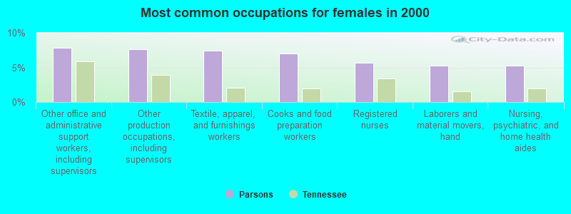
- Other office and administrative support workers, including supervisors (7.8%)
- Other production occupations, including supervisors (7.6%)
- Textile, apparel, and furnishings workers (7.4%)
- Cooks and food preparation workers (7.0%)
- Registered nurses (5.7%)
- Laborers and material movers, hand (5.2%)
- Nursing, psychiatric, and home health aides (5.2%)
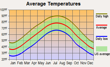
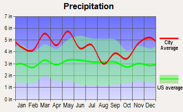
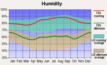
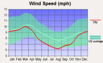
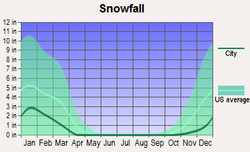
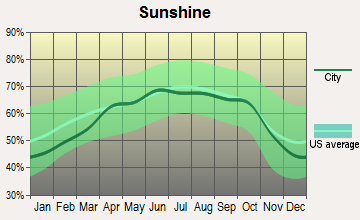
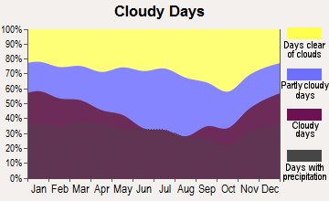
Average climate in Parsons, Tennessee
Based on data reported by over 4,000 weather stations
|
|


Tornado activity:
Parsons-area historical tornado activity is slightly above Tennessee state average. It is 79% greater than the overall U.S. average.
On 3/21/1952, a category F4 (max. wind speeds 207-260 mph) tornado 8.9 miles away from the Parsons city center killed 38 people and injured 157 people and caused between $500,000 and $5,000,000 in damages.
On 4/16/1998, a category F5 (max. wind speeds 261-318 mph) tornado 30.2 miles away from the city center killed 3 people and injured 36 people and caused $13 million in damages.
Earthquake activity:
Parsons-area historical earthquake activity is significantly above Tennessee state average. It is 278% greater than the overall U.S. average.On 4/18/2008 at 09:36:59, a magnitude 5.4 (5.1 MB, 4.8 MS, 5.4 MW, 5.2 MW, Class: Moderate, Intensity: VI - VII) earthquake occurred 194.3 miles away from Parsons center
On 5/4/1991 at 01:18:54, a magnitude 5.0 (4.4 MB, 4.6 LG, 5.0 LG, Depth: 3.1 mi) earthquake occurred 114.1 miles away from the city center
On 3/25/1976 at 00:41:20, a magnitude 5.0 (4.9 MB, 5.0 LG) earthquake occurred 123.9 miles away from the city center
On 9/26/1990 at 13:18:51, a magnitude 5.0 (4.7 MB, 4.8 LG, 5.0 LG, Depth: 7.7 mi) earthquake occurred 131.2 miles away from the city center
On 4/18/2008 at 09:36:59, a magnitude 5.2 (5.2 MW, Depth: 8.9 mi) earthquake occurred 194.3 miles away from Parsons center
On 4/27/1989 at 16:47:49, a magnitude 4.7 (4.6 MB, 4.7 LG, 4.3 LG, Class: Light, Intensity: IV - V) earthquake occurred 95.5 miles away from the city center
Magnitude types: regional Lg-wave magnitude (LG), body-wave magnitude (MB), surface-wave magnitude (MS), moment magnitude (MW)
Natural disasters:
The number of natural disasters in Decatur County (19) is greater than the US average (15).Major Disasters (Presidential) Declared: 15
Emergencies Declared: 1
Causes of natural disasters: Storms: 15, Floods: 13, Tornadoes: 8, Winds: 6, Flash Flood: 1, Hurricane: 1, Ice Storm: 1, Landslide: 1, Mudslide: 1, Winter Storm: 1, Other: 1 (Note: some incidents may be assigned to more than one category).
Hospitals and medical centers in Parsons:
- DECATUR COUNTY GENERAL HOSPITAL (Government - Local, provides emergency services, 969 TENNESSEE AVE S)
- (CLOSED) GOLDEN BUTTERFLY HC (766 TENNESSEE AVE)
- TENNESSEE QUALITY HOMECARE SW (580 TENNESSEE AVENUE NORTH)
- VOLUNTEER HOMECARE OF WEST TN (405 TENNESSEE AVENUE SOUTH)
- DECATUR COUNTY MANOR (726 KENTUCKY AVE)
Heliports located in Parsons:
Colleges/universities with over 2000 students nearest to Parsons:
- Jackson State Community College (about 38 miles; Jackson, TN; Full-time enrollment: 2,958)
- Bethel University (about 41 miles; McKenzie, TN; FT enrollment: 5,878)
- Union University (about 42 miles; Jackson, TN; FT enrollment: 4,051)
- Columbia State Community College (about 58 miles; Columbia, TN; FT enrollment: 3,383)
- The University of Tennessee-Martin (about 64 miles; Martin, TN; FT enrollment: 7,013)
- University of North Alabama (about 64 miles; Florence, AL; FT enrollment: 5,886)
- Murray State University (about 68 miles; Murray, KY; FT enrollment: 8,930)
Public elementary/middle schools in Parsons:
- DECATUR COUNTY MIDDLE SCHOOL (Students: 491, Location: 2740 HWY 641 SOUTH, Grades: 5-8)
- PARSONS ELEMENTARY (Students: 426, Location: 182 WEST 4TH ST, Grades: PK-4)
Points of interest:
Notable locations in Parsons: City of Parsons Fire Department (A), Decatur County Volunteer Fire Department Station 1 (B), Decatur County Rescue Squad (C). Display/hide their locations on the map
Churches in Parsons include: Cross Roads Baptist Church (A), Parsons United Methodist Church (B), Parsons First Baptist Church (C), First United Pentecostal Church (D). Display/hide their locations on the map
Cemetery: Parsons Cemetery (1). Display/hide its location on the map
Streams, rivers, and creeks: Buckner Branch (A). Display/hide its location on the map
Hotels: Deerfield Inn (863 Tennessee Avenue North), Jake's Motor Inn (3946 Highway 412 East).
Birthplace of: Little David Wilkins - Country musician, Calvin Garrett - Basketball player.
Drinking water stations with addresses in Parsons and their reported violations in the past:
PARSONS WATER DEPARTMENT (Population served: 4,063, Surface water):Past monitoring violations:NORTH U.D. OF DECATUR/BENTON CO. (Population served: 3,131, Surface water):
- Monitoring and Reporting (DBP) - Between APR-2012 and JUN-2012, Contaminant: Chlorine. Follow-up actions: St Violation/Reminder Notice (AUG-31-2012), St Public Notif requested (AUG-31-2012)
- Monitoring and Reporting (DBP) - Between JAN-2007 and MAR-2007, Contaminant: Total Haloacetic Acids (HAA5). Follow-up actions: St Public Notif requested (APR-18-2007), St Violation/Reminder Notice (APR-18-2007), St Public Notif received (JUN-01-2007), St Compliance achieved (JUN-27-2007), St Civil Case under development (JUL-18-2008), St AO (w/penalty) issued (SEP-09-2008)
- Monitoring and Reporting (DBP) - Between JAN-2007 and MAR-2007, Contaminant: TTHM. Follow-up actions: St Public Notif requested (APR-18-2007), St Violation/Reminder Notice (APR-18-2007), St Public Notif received (JUN-01-2007), St Compliance achieved (JUN-27-2007), St Civil Case under development (JUL-18-2008), St AO (w/penalty) issued (SEP-09-2008)
- Monitoring and Reporting (DBP) - Between OCT-2006 and DEC-2006, Contaminant: Total Haloacetic Acids (HAA5). Follow-up actions: St Public Notif requested (APR-18-2007), St Violation/Reminder Notice (APR-18-2007), St Public Notif received (JUN-01-2007), St Compliance achieved (JUN-27-2007), St Civil Case under development (JUL-18-2008), St AO (w/penalty) issued (SEP-09-2008)
- Monitoring and Reporting (DBP) - Between OCT-2006 and DEC-2006, Contaminant: TTHM. Follow-up actions: St Public Notif requested (APR-18-2007), St Violation/Reminder Notice (APR-18-2007), St Public Notif received (JUN-01-2007), St Compliance achieved (JUN-27-2007), St Civil Case under development (JUL-18-2008), St AO (w/penalty) issued (SEP-09-2008)
- 2 minor monitoring violations
Past health violations:PERRYVILLE UTILITY DISTRICT (Population served: 3,107, Purch surface water):Past monitoring violations:
- MCL, Average - Between OCT-2011 and DEC-2011, Contaminant: TTHM. Follow-up actions: St Public Notif requested (JAN-23-2012), St Violation/Reminder Notice (JAN-23-2012), St Public Notif received (FEB-21-2012), St Compliance achieved (MAR-06-2012)
- MCL, Average - Between JUL-2011 and SEP-2011, Contaminant: TTHM. Follow-up actions: St Public Notif requested (NOV-02-2011), St Violation/Reminder Notice (NOV-02-2011), St Public Notif received (NOV-21-2011), St Compliance achieved (MAR-06-2012)
- MCL, Average - Between APR-2011 and JUN-2011, Contaminant: TTHM. Follow-up actions: St Public Notif requested (AUG-03-2011), St Violation/Reminder Notice (AUG-03-2011), St Public Notif received (AUG-22-2011), St Compliance achieved (MAR-06-2012)
- MCL, Average - Between JAN-2011 and MAR-2011, Contaminant: TTHM. Follow-up actions: St Public Notif requested (APR-18-2011), St Violation/Reminder Notice (APR-18-2011), St Public Notif received (APR-25-2011), St Compliance achieved (MAR-06-2012)
- MCL, Average - Between OCT-2010 and DEC-2010, Contaminant: TTHM. Follow-up actions: St Public Notif requested (JAN-14-2011), St Violation/Reminder Notice (JAN-14-2011), St Public Notif received (JAN-24-2011), St Compliance achieved (MAR-06-2012)
- Monitoring and Reporting (DBP) - Between JUL-2011 and SEP-2011, Contaminant: CARBON, TOTAL. Follow-up actions: St Public Notif requested (NOV-01-2011), St Violation/Reminder Notice (NOV-01-2011), St Compliance achieved (DEC-31-2011), St Public Notif received (JUN-11-2012)
- Monitoring, Turbidity (Enhanced SWTR) - In OCT-2007, Contaminant: IESWTR. Follow-up actions: St Compliance achieved (NOV-30-2007), St Public Notif requested (DEC-03-2007), St Violation/Reminder Notice (DEC-03-2007)
- Monitoring, Turbidity (Enhanced SWTR) - In JUN-2005, Contaminant: IESWTR. Follow-up actions: St Compliance achieved (JUL-01-2005), St Public Notif requested (AUG-05-2005), St Violation/Reminder Notice (AUG-05-2005)
- Monitoring, Turbidity (Enhanced SWTR) - In FEB-2005, Contaminant: IESWTR. Follow-up actions: St Compliance achieved (MAR-01-2005), St Public Notif requested (MAR-31-2005), St Violation/Reminder Notice (MAR-31-2005)
- Monitoring, Turbidity (Enhanced SWTR) - In JAN-2005, Contaminant: IESWTR. Follow-up actions: St Violation/Reminder Notice (FEB-28-2005), St Public Notif requested (FEB-28-2005), St Compliance achieved (MAR-01-2005), St Public Notif requested (MAR-22-2005), St Violation/Reminder Notice (MAR-22-2005)
- 2 regular monitoring violations
Past health violations:Past monitoring violations:
- MCL, Average - Between OCT-2009 and DEC-2009, Contaminant: Total Haloacetic Acids (HAA5). Follow-up actions: St Public Notif requested (JAN-22-2010), St Violation/Reminder Notice (JAN-22-2010), St Compliance achieved (FEB-09-2010), St Public Notif received (2 times from FEB-25-2010 to MAY-15-2010)
- Monitoring and Reporting (DBP) - Between JUL-2006 and SEP-2006, Contaminant: Total Haloacetic Acids (HAA5). Follow-up actions: St Public Notif requested (OCT-27-2006), St Violation/Reminder Notice (OCT-27-2006), St Compliance achieved (NOV-08-2006), St Public Notif received (JUN-01-2007)
- Monitoring and Reporting (DBP) - Between JUL-2006 and SEP-2006, Contaminant: TTHM. Follow-up actions: St Public Notif requested (OCT-27-2006), St Violation/Reminder Notice (OCT-27-2006), St Compliance achieved (NOV-08-2006), St Public Notif received (JUN-01-2007)
- One minor monitoring violation
- One regular monitoring violation
| This city: | 2.3 people |
| Tennessee: | 2.5 people |
| This city: | 60.6% |
| Whole state: | 67.3% |
| This city: | 5.5% |
| Whole state: | 5.8% |
Likely homosexual households (counted as self-reported same-sex unmarried-partner households)
- Lesbian couples: 0.3% of all households
- Gay men: 0.2% of all households
142 people in nursing homes in 2000
Banks with branches in Parsons (2011 data):
- Community South Bank: Parsons Branch, Parsons Drive Thru Branch, at 51 West Main Street. Info updated 2007/01/18: Bank assets: $569.9 mil, Deposits: $534.2 mil, local headquarters, negative income in the last year, Commercial Lending Specialization, 23 total offices, Holding Company: Tennessee Central Bancshares, Inc.
- First Bank: Parsons Branch at 450 Tennessee Avenue South, branch established on 2007/10/15. Info updated 2012/02/21: Bank assets: $2,074.4 mil, Deposits: $1,734.5 mil, headquarters in Lexington, TN, positive income, Commercial Lending Specialization, 54 total offices, Holding Company: First South Bancorp, Inc.
- Decatur County Bank: Parsons Branch at 300 South Tennessee Avenue, branch established on 1979/10/15. Info updated 2006/11/03: Bank assets: $90.2 mil, Deposits: $77.5 mil, headquarters in Decaturville, TN, negative income in the last year, Commercial Lending Specialization, 3 total offices, Holding Company: Decatur Bancshares, Inc
- Farmers Bank: at 29 East Main Street, branch established on 1907/03/09. Info updated 2008/09/09: Bank assets: $36.7 mil, Deposits: $32.2 mil, local headquarters, positive income, 1 total offices, Holding Company: Townsend Financial Corporation
For population 15 years and over in Parsons:
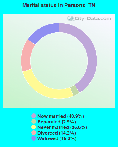
- Never married: 26.6%
- Now married: 40.9%
- Separated: 2.9%
- Widowed: 15.4%
- Divorced: 14.2%
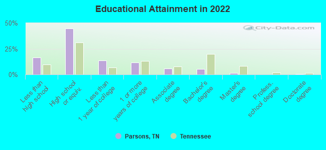
For population 25 years and over in Parsons:
- High school or higher: 82.1%
- Bachelor's degree or higher: 7.2%
- Graduate or professional degree: 2.2%
- Unemployed: 6.8%
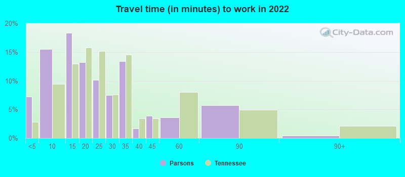
- Mean travel time to work (commute): 18.9 minutes

| Here: | 11.9 |
| Tennessee average: | 11.4 |
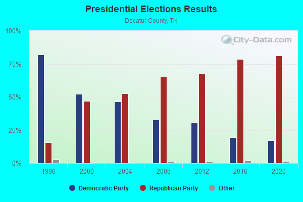
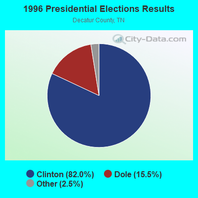
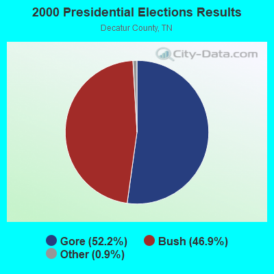
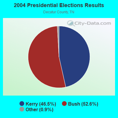
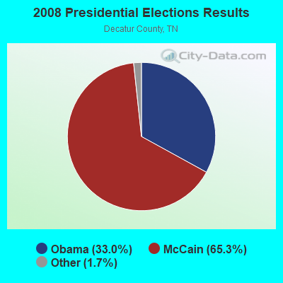
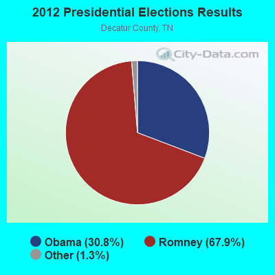
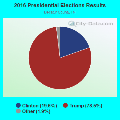
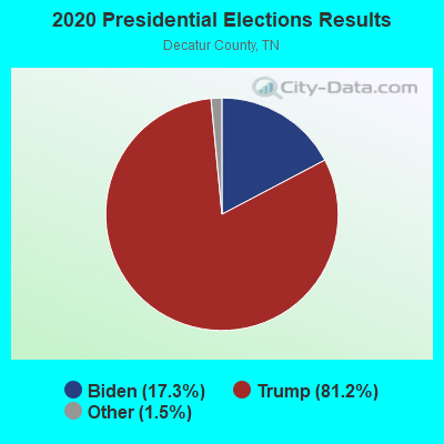
Graphs represent county-level data. Detailed 2008 Election Results
Religion statistics for Parsons, TN (based on Decatur County data)
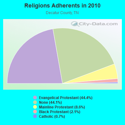
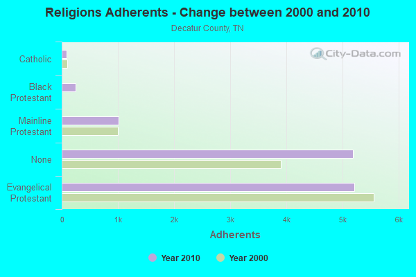
| Religion | Adherents | Congregations |
|---|---|---|
| Evangelical Protestant | 5,215 | 37 |
| Mainline Protestant | 1,013 | 11 |
| Black Protestant | 251 | 4 |
| Catholic | 88 | 1 |
| Other | - | - |
| None | 5,190 | - |
Food Environment Statistics:
| Decatur County: | 4.41 / 10,000 pop. |
| Tennessee: | 1.99 / 10,000 pop. |
| Here: | 2.65 / 10,000 pop. |
| State: | 0.65 / 10,000 pop. |
| Decatur County: | 10.60 / 10,000 pop. |
| Tennessee: | 5.16 / 10,000 pop. |
| Decatur County: | 9.71 / 10,000 pop. |
| Tennessee: | 6.56 / 10,000 pop. |
| Decatur County: | 12.4% |
| State: | 11.4% |
| This county: | 27.9% |
| Tennessee: | 30.2% |
| This county: | 11.8% |
| Tennessee: | 13.5% |
Health and Nutrition:
| Parsons: | 44.7% |
| Tennessee: | 49.3% |
| Parsons: | 36.1% |
| Tennessee: | 46.1% |
| Parsons: | 28.1 |
| Tennessee: | 28.8 |
| Parsons: | 18.3% |
| State: | 21.0% |
| Here: | 7.2% |
| Tennessee: | 10.5% |
| Here: | 6.7 |
| Tennessee: | 6.8 |
| Parsons: | 28.9% |
| Tennessee: | 33.9% |
| This city: | 49.8% |
| Tennessee: | 55.9% |
| Parsons: | 73.9% |
| Tennessee: | 79.1% |
More about Health and Nutrition of Parsons, TN Residents
| Local government employment and payroll (March 2022) | |||||
| Function | Full-time employees | Monthly full-time payroll | Average yearly full-time wage | Part-time employees | Monthly part-time payroll |
|---|---|---|---|---|---|
| Water Supply | 9 | $20,021 | $26,695 | 1 | $1,519 |
| Police Protection - Officers | 6 | $21,015 | $42,030 | 3 | $5,669 |
| Streets and Highways | 5 | $15,579 | $37,390 | 1 | $3,186 |
| Gas Supply | 5 | $18,394 | $44,146 | 8 | $8,610 |
| Other Government Administration | 4 | $13,387 | $40,161 | 12 | $1,499 |
| Other and Unallocable | 2 | $6,220 | $37,320 | 7 | $2,161 |
| Solid Waste Management | 2 | $5,033 | $30,198 | 0 | $0 |
| Sewerage | 1 | $3,569 | $42,828 | 0 | $0 |
| Local Libraries | 0 | $0 | 5 | $5,717 | |
| Judicial and Legal | 0 | $0 | 1 | $449 | |
| Totals for Government | 34 | $103,218 | $36,430 | 38 | $28,810 |
Parsons government finances - Expenditure in 2017 (per resident):
- Current Operations - Gas Utilities: $1,725,000 ($815.99)
Water Utilities: $841,000 ($397.82)
Police Protection: $439,000 ($207.66)
Regular Highways: $321,000 ($151.84)
Sewerage: $315,000 ($149.01)
Financial Administration: $139,000 ($65.75)
Parks and Recreation: $88,000 ($41.63)
Solid Waste Management: $70,000 ($33.11)
Libraries: $56,000 ($26.49)
Air Transportation: $40,000 ($18.92)
Housing and Community Development: $25,000 ($11.83)
Local Fire Protection: $23,000 ($10.88)
- Gas Utilities - Interest on Debt: $6,000 ($2.84)
- Other Capital Outlay - Parks and Recreation: $144,000 ($68.12)
Police Protection: $70,000 ($33.11)
- Total Salaries and Wages: $1,534,000 ($725.64)
- Water Utilities - Interest on Debt: $214,000 ($101.23)
Parsons government finances - Revenue in 2017 (per resident):
- Charges - Solid Waste Management: $73,000 ($34.53)
- Miscellaneous - Sale of Property: $388,000 ($183.54)
Rents: $240,000 ($113.53)
General Revenue - Other: $36,000 ($17.03)
Fines and Forfeits: $28,000 ($13.25)
Donations From Private Sources: $10,000 ($4.73)
Interest Earnings: $4,000 ($1.89)
- Revenue - Gas Utilities: $2,182,000 ($1032.17)
Water Utilities: $1,425,000 ($674.08)
- State Intergovernmental - Health and Hospitals: $150,000 ($70.96)
Highways: $71,000 ($33.59)
Public Welfare: $70,000 ($33.11)
Housing and Community Development: $54,000 ($25.54)
General Local Government Support: $25,000 ($11.83)
- Tax - General Sales and Gross Receipts: $613,000 ($289.97)
Property: $503,000 ($237.94)
Alcoholic Beverage Sales: $105,000 ($49.67)
Public Utilities Sales: $31,000 ($14.66)
Other: $21,000 ($9.93)
Occupation and Business License - Other: $8,000 ($3.78)
Alcoholic Beverage License: $1,000 ($0.47)
Parsons government finances - Debt in 2017 (per resident):
- Long Term Debt - Beginning Outstanding - Unspecified Public Purpose: $5,499,000 ($2601.23)
Outstanding Unspecified Public Purpose: $4,462,000 ($2110.69)
Retired Unspecified Public Purpose: $1,037,000 ($490.54)
Parsons government finances - Cash and Securities in 2017 (per resident):
- Other Funds - Cash and Securities: $9,269,000 ($4384.58)
| Businesses in Parsons, TN | ||||
| Name | Count | Name | Count | |
|---|---|---|---|---|
| Ace Hardware | 1 | La-Z-Boy | 1 | |
| FedEx | 1 | RadioShack | 1 | |
| Ford | 1 | SONIC Drive-In | 1 | |
| H&R Block | 1 | Subway | 1 | |
| Hardee's | 1 | UPS | 1 | |
Strongest AM radio stations in Parsons:
- WKJQ (1550 AM; daytime; 1 kW; PARSONS, TN; Owner: CLENNEY BROADCASTING CORPORATION)
- WSM (650 AM; 50 kW; NASHVILLE, TN; Owner: GAYLORD ENTERTAINMENT COMPANY)
- WKDA (1200 AM; 50 kW; NASHVILLE, TN; Owner: RADIO NASHVILLE, INC.)
- WNQM (1300 AM; 50 kW; NASHVILLE, TN; Owner: WNQM. INC.)
- WCRV (640 AM; 50 kW; COLLIERVILLE, TN; Owner: BOTT BROADCASTING COMPANY/TENNESSEE)
- WAMB (1160 AM; 50 kW; DONELSON, TN; Owner: GREAT SOUTHERN BROADCASTING COMPANY, INC.)
- WLAC (1510 AM; 50 kW; NASHVILLE, TN; Owner: CAPSTAR TX LIMITED PARTNERSHIP)
- WGSF (1030 AM; 50 kW; MEMPHIS, TN; Owner: FLINN BROADCASTING CORPORATION)
- WDIA (1070 AM; 50 kW; MEMPHIS, TN; Owner: CLEAR CHANNEL BROADCASTING LICENSES, INC.)
- WMQM (1600 AM; 50 kW; LAKELAND, TN; Owner: WMQM, INC.)
- WLOR (1550 AM; 50 kW; HUNTSVILLE, AL; Owner: BCA RADIO, LLC)
- WCPC (940 AM; 50 kW; HOUSTON, MS; Owner: WCPC BROADCASTING CO., INC.)
- WDXL (1490 AM; 1 kW; LEXINGTON, TN; Owner: LEXINGTON BROADCASTING SERVICE, INC.)
Strongest FM radio stations in Parsons:
- WKJQ-FM (97.3 FM; PARSONS, TN; Owner: CLENNEY BROADCASTING CORPORATION)
- WFGZ (94.5 FM; LOBELVILLE, TN; Owner: OHIO BROADCAST ASSOCIATES)
- WLVS-FM (106.5 FM; CLIFTON, TN; Owner: GOLD COAST BROADCASTING CO.)
- WBFG (96.5 FM; PARKER'S CROSSROADS, TN; Owner: CROSSROADS BROADCASTING, LLC)
- WYNU (92.3 FM; MILAN, TN; Owner: CAPSTAR TX LIMITED PARTNERSHIP)
- WAYW (89.9 FM; NEW JOHNSONVILLE, TN; Owner: WAY-FM MEDIA GROUP, INC.)
- WIGH (88.7 FM; LEXINGTON, TN; Owner: AMERICAN FAMILY ASSOCIATION)
- WWYN (106.9 FM; MCKENZIE, TN; Owner: RAINBOW MEDIA, INC.)
- WDNX (89.1 FM; OLIVE HILL, TN; Owner: RURAL LIFE FOUNDATION, INC)
- WZLT (99.3 FM; LEXINGTON, TN; Owner: LEXINGTON BROADCASTING SERVICES, INC)
TV broadcast stations around Parsons:
- WBBJ-TV (Channel 7; JACKSON, TN; Owner: TENNESSEE BROADCASTING PARTNERS)
- WLJT (Channel 11; LEXINGTON, TN; Owner: WEST TENNESSEE PUBLIC TV COUNCIL, INC)
- W26CJ (Channel 26; JACKSON, TN; Owner: MS COMMUNICATIONS, LLC)
- WJTE-LP (Channel 19; JACKSON, TN; Owner: TIGER EYE BROADCASTING CORPORATION)
- W22BR (Channel 22; JACKSON, TN; Owner: MS COMMUNICATIONS, LLC)
- W52CZ (Channel 52; JACKSON, TN; Owner: MS COMMUNICATIONS, LLC)
- W64BZ (Channel 64; JACKSON, TN; Owner: MS COMMUNICATIONS, LLC)
- W25BY (Channel 25; JACKSON, TN; Owner: MS COMMUNICATIONS, LLC)
- W38BY (Channel 38; JACKSON, TN; Owner: MS COMMUNICATIONS, LLC)
- W54BU (Channel 54; JACKSON, TN; Owner: MS COMMUNICATIONS, LLC)
- National Bridge Inventory (NBI) Statistics
- 21Number of bridges
- 144ft / 43.6mTotal length
- $4,400,000Total costs
- 41,136Total average daily traffic
- 3,873Total average daily truck traffic
- 66,627Total future (year 2040) average daily traffic
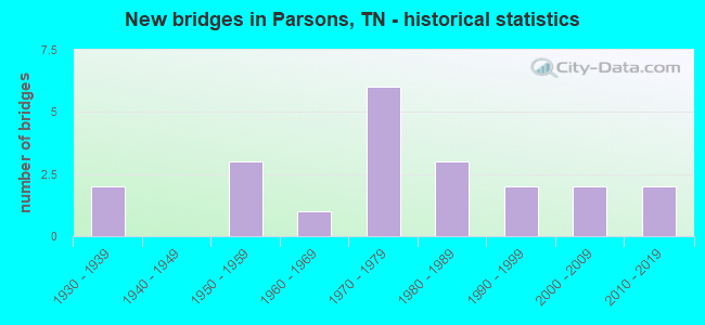
- New bridges - historical statistics
- 21930-1939
- 31950-1959
- 11960-1969
- 61970-1979
- 31980-1989
- 21990-1999
- 22000-2009
- 22010-2019
FCC Registered Cell Phone Towers:
1 (See the full list of FCC Registered Cell Phone Towers in Parsons)FCC Registered Antenna Towers:
23 (See the full list of FCC Registered Antenna Towers)FCC Registered Private Land Mobile Towers:
1- Hickerson Rd (Lat: 35.820611 Lon: -88.161972), Type: Tower, Structure height: 67 m, Call Sign: WPIF998,
Assigned Frequencies: 929.287 MHz, 929.562 MHz, 929.612 MHz, 929.962 MHz, Grant Date: 01/19/2001, Expiration Date: 09/13/2010, Cancellation Date: 07/03/2002, Certifier: Paul H Kuzia, Registrant: Wilkinson Barker Knauer, LLP, 2300 N Street, N.W., Suite 700, Washington, DC 20037-1128, Phone: (202) 783-4141, Fax: (202) 783-5851, Email:
FCC Registered Broadcast Land Mobile Towers:
5- 1110 S Tennessee Ave (Lat: 35.647278 Lon: -88.094472), Call Sign: KNDP513,
Assigned Frequencies: 462.950 MHz, 462.975 MHz, 463.000 MHz, 463.025 MHz, 463.050 MHz, 463.075 MHz, 463.100 MHz, 463.125 MHz, 463.150 MHz, 463.175 MHz, Grant Date: 08/15/1995, Expiration Date: 08/20/2000, Cancellation Date: 10/29/2000, Registrant: State Of Tennessee, 287 Plus Park Blvd, Nashville, TN 37247-0701, Phone: (901) 847-3031
- City Water Reservoir (Lat: 35.647833 Lon: -88.123361), Type: Tank, Structure height: 24 m, Overall height: 30 m, Call Sign: KWM862,
Assigned Frequencies: 155.340 MHz, Grant Date: 05/05/2015, Expiration Date: 07/26/2025, Certifier: Larry Marshall, Registrant: Universal Licensing Service, 4401-A Connecticut Ave Nw #232, Washington, DC 20008-2358, Phone: (877) 677-3639, Email:
- Lat: 35.651917 Lon: -88.127056, Call Sign: WPZR886,
Assigned Frequencies: 468.762 MHz, 468.837 MHz, 469.137 MHz, 469.462 MHz, 469.637 MHz, 469.662 MHz, 469.887 MHz, 457.512 MHz, 457.537 MHz, 457.562 MHz, 457.587 MHz, 457.612 MHz, Grant Date: 03/01/2004, Expiration Date: 03/01/2014, Cancellation Date: 05/03/2014, Certifier: Kim Matthews, Registrant: Business Radio Licensing, 26941 Cabot Rd #134, Laguna Hills, CA 92653, Phone: (949) 348-8510, Fax: (858) 452-7207, Email:
- BEECH RIVER REGIONAL, Beech River Regional Airport (Lat: 35.656417 Lon: -88.197667), Type: Building, Structure height: 4.6 m, Overall height: 5.6 m, Call Sign: WQEG426,
Assigned Frequencies: 453.162 MHz, Grant Date: 10/24/2015, Expiration Date: 01/19/2026, Certifier: Michael A Carroll, Registrant: Tdot Wireless Systems Licensing, 6600 Centennial Blvd, Nashville, TN 37243-0365, Phone: (615) 350-3430, Email:
- 5445 Hwy 412e (Lat: 35.628611 Lon: -88.035556), Call Sign: WQSE205,
Assigned Frequencies: 160.050 MHz, Grant Date: 08/11/2023, Expiration Date: 09/09/2033, Certifier: Mark Clark, Registrant: B&e Electronics Inc., 3890 Hwy 45 N, Jackson, TN 38305, Phone: (731) 668-0325, Fax: (731) 668-3178, Email:
FCC Registered Microwave Towers:
5 (See the full list of FCC Registered Microwave Towers in this town)FCC Registered Paging Towers:
2 (See the full list of FCC Registered Paging Towers)FCC Registered Maritime Coast & Aviation Ground Towers:
3 (See the full list of FCC Registered Maritime Coast & Aviation Ground Towers)FCC Registered Amateur Radio Licenses:
36 (See the full list of FCC Registered Amateur Radio Licenses in Parsons)FAA Registered Aircraft Manufacturers and Dealers:
5 (See the full list of FAA Registered Manufacturers and Dealers in Parsons)FAA Registered Aircraft:
9 (See the full list of FAA Registered Aircraft)2004 - 2018 National Fire Incident Reporting System (NFIRS) incidents
- Fire incident types reported to NFIRS in Parsons, TN
- 23644.2%Structure Fires
- 19135.8%Outside Fires
- 8716.3%Mobile Property/Vehicle Fires
- 203.7%Other
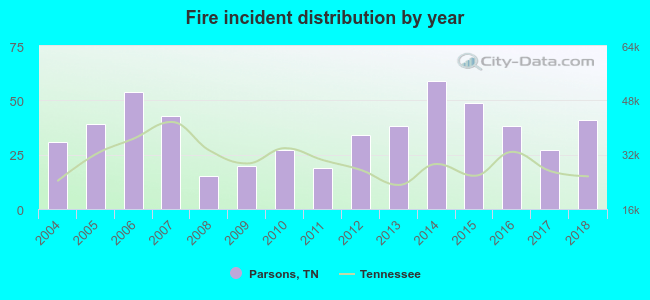 According to the data from the years 2004 - 2018 the average number of fires per year is 36. The highest number of fires - 59 took place in 2014, and the least - 15 in 2008. The data has a growing trend.
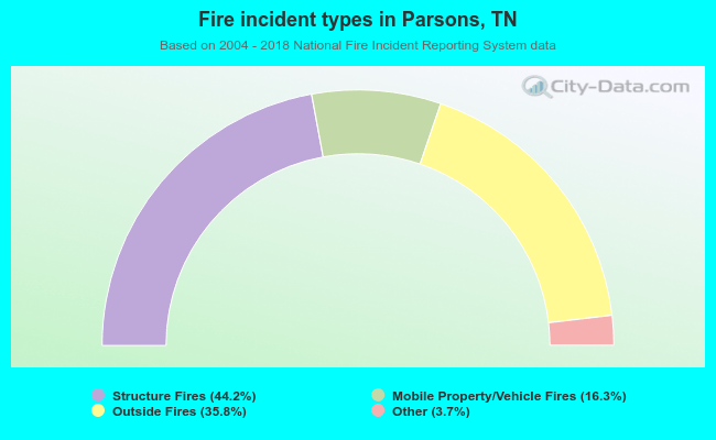 When looking into fire subcategories, the most incidents belonged to: Structure Fires (44.2%), and Outside Fires (35.8%).
| Most common first names in Parsons, TN among deceased individuals | ||
| Name | Count | Lived (average) |
|---|---|---|
| James | 95 | 75.5 years |
| William | 67 | 76.5 years |
| Mary | 61 | 79.1 years |
| John | 60 | 75.9 years |
| Robert | 38 | 72.1 years |
| Willie | 31 | 77.8 years |
| Thomas | 21 | 73.5 years |
| George | 18 | 76.3 years |
| Ruby | 17 | 80.8 years |
| Joe | 17 | 77.7 years |
| Most common last names in Parsons, TN among deceased individuals | ||
| Last name | Count | Lived (average) |
|---|---|---|
| Moore | 43 | 76.4 years |
| Taylor | 33 | 74.4 years |
| Smith | 31 | 75.9 years |
| Miller | 29 | 75.1 years |
| Quinn | 27 | 75.3 years |
| Tolley | 25 | 73.6 years |
| Gibson | 25 | 78.9 years |
| Houston | 23 | 85.0 years |
| Wilkins | 23 | 82.6 years |
| Johnson | 22 | 78.0 years |
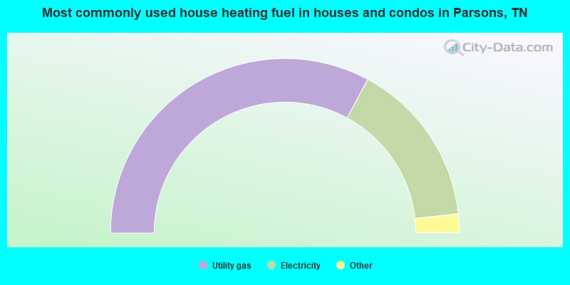
- 65.8%Utility gas
- 30.8%Electricity
- 2.9%Fuel oil, kerosene, etc.
- 0.5%Bottled, tank, or LP gas
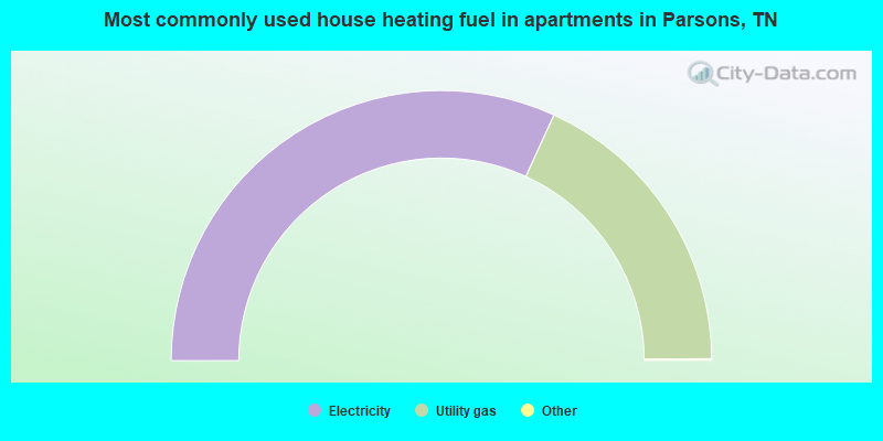
- 63.8%Electricity
- 36.2%Utility gas
Parsons compared to Tennessee state average:
- Median household income below state average.
- Median house value below state average.
- Unemployed percentage below state average.
- Black race population percentage below state average.
- Hispanic race population percentage significantly below state average.
- Foreign-born population percentage significantly below state average.
- Length of stay since moving in significantly above state average.
- Institutionalized population percentage above state average.
- Number of college students below state average.
- Percentage of population with a bachelor's degree or higher significantly below state average.
Parsons on our top lists:
- #41 on the list of "Top 101 cities with the largest percentage of people in dormitories (population 1,000+)"
- #41 on the list of "Top 101 cities with the largest percentage of people in group homes (population 1,000+)"
- #41 on the list of "Top 101 cities with the largest percentage of people in hospitals/wards, hospices, and schools for the handicapped (population 1,000+)"
- #41 on the list of "Top 101 cities with the largest percentage of people in long-term care (population 1,000+)"
- #41 on the list of "Top 101 cities with the largest percentage of people in military quarters (population 1,000+)"
- #41 on the list of "Top 101 cities with the largest percentage of people in noninstitutionalized settings (population 1,000+)"
- #41 on the list of "Top 101 cities with the largest percentage of people in on base quarters (population 1,000+)"
- #41 on the list of "Top 101 cities with the largest percentage of people in schools, hospitals, or wards for the physically handicapped (population 1,000+)"
- #48 on the list of "Top 101 cities with the largest percentage of people in wards in military hospitals for patients who have no usual home elsewhere (population 1,000+)"
- #56 on the list of "Top 101 cities with the largest percentage of people in military disciplinary barracks (population 1,000+)"
- #58 on the list of "Top 101 cities with the largest percentage of people in military hospitals or wards for chronically ill (population 1,000+)"
- #60 on the list of "Top 101 cities with the largest percentage of people in institutions for the deaf (population 1,000+)"
- #64 on the list of "Top 101 cities with the largest percentage of people in institutions for the blind (population 1,000+)"

|
Total of 3 patent applications in 2008-2024.