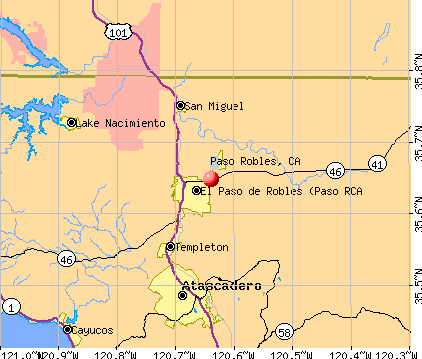
Paso Robles, California
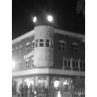
Paso Robles: Downtown City Clock
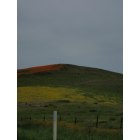
Paso Robles: Hills full of Wilflowers
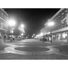
Paso Robles: Downtown Paso Robles
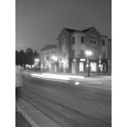
Paso Robles: 4th street med stop building
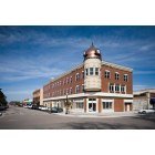
Paso Robles: Landmark building at the center of Paso Robles. Rebuilt after the 6.5 earthquake took the building down.
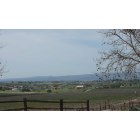
Paso Robles: Peaceful Valley and Red Barn Beyond the Vineyards
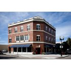
Paso Robles: Paso Rboles Ca. A complete reconstruction of the original building build back in 1892. This was one of the buildings suffering heavy damage in the 6.5 earthquake that was centered in San Simion 28 miles to the west of Paso Robles CA.
- add
your
Submit your own pictures of this place and show them to the world
- OSM Map
- General Map
- Google Map
- MSN Map
| Males: 21,671 | |
| Females: 21,080 |
| Median resident age: | 35.8 years |
| California median age: | 33.3 years |
Zip code: 93446
| Paso Robles: | $89,865 |
| CA: | $91,551 |
Estimated per capita income in 2022: $48,377 (it was $20,115 in 2000)
Paso Robles CCD income, earnings, and wages data
Estimated median house or condo value in 2022: $616,929 (it was $173,700 in 2000)
| Paso Robles: | $616,929 |
| CA: | $715,900 |
Mean prices in 2022: all housing units: $895,490; detached houses: $974,282; townhouses or other attached units: $627,105; in 2-unit structures: $719,918; in 3-to-4-unit structures: $546,505; in 5-or-more-unit structures: $432,833; mobile homes: $416,411; occupied boats, rvs, vans, etc.: $73,149
Detailed information about poverty and poor residents in Paso Robles, CA


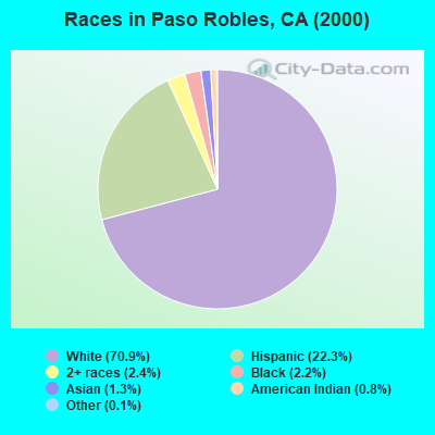
- 28,70670.9%White alone
- 9,04122.3%Hispanic
- 9532.4%Two or more races
- 8802.2%Black alone
- 5251.3%Asian alone
- 3130.8%American Indian alone
- 530.1%Other race alone
- 220.05%Native Hawaiian and Other
Pacific Islander alone
According to our research of California and other state lists, there were 49 registered sex offenders living in Paso Robles, California as of April 27, 2024.
The ratio of all residents to sex offenders in Paso Robles is 872 to 1.
The ratio of registered sex offenders to all residents in this city is near the state average.
Type |
2009 |
2010 |
2011 |
2012 |
2013 |
2014 |
2015 |
2016 |
2017 |
2018 |
2019 |
2020 |
2022 |
|---|---|---|---|---|---|---|---|---|---|---|---|---|---|
| Murders (per 100,000) | 0 (0.0) | 0 (0.0) | 2 (6.6) | 1 (3.3) | 2 (6.5) | 0 (0.0) | 0 (0.0) | 0 (0.0) | 0 (0.0) | 0 (0.0) | 0 (0.0) | 3 (9.3) | 0 (0.0) |
| Rapes (per 100,000) | 15 (51.4) | 13 (43.6) | 11 (36.5) | 6 (19.8) | 8 (26.0) | 6 (19.3) | 4 (12.6) | 8 (25.0) | 3 (9.3) | 13 (40.3) | 9 (27.7) | 2 (6.2) | 13 (40.7) |
| Robberies (per 100,000) | 11 (37.7) | 15 (50.3) | 12 (39.8) | 6 (19.8) | 6 (19.5) | 7 (22.5) | 12 (37.9) | 20 (62.6) | 6 (18.6) | 7 (21.7) | 13 (40.0) | 8 (24.7) | 14 (43.8) |
| Assaults (per 100,000) | 67 (229.4) | 67 (224.9) | 70 (232.2) | 78 (257.1) | 87 (282.5) | 112 (359.9) | 46 (145.3) | 39 (122.1) | 26 (80.6) | 23 (71.4) | 31 (95.3) | 40 (123.4) | 71 (222.1) |
| Burglaries (per 100,000) | 267 (914.3) | 268 (899.5) | 148 (491.0) | 152 (500.9) | 211 (685.2) | 157 (504.5) | 169 (533.8) | 144 (450.9) | 126 (390.5) | 133 (412.7) | 78 (239.8) | 35 (107.9) | 42 (131.4) |
| Thefts (per 100,000) | 595 (2,037) | 688 (2,309) | 632 (2,097) | 578 (1,905) | 595 (1,932) | 584 (1,877) | 848 (2,679) | 738 (2,311) | 731 (2,266) | 610 (1,893) | 523 (1,608) | 295 (909.7) | 433 (1,355) |
| Auto thefts (per 100,000) | 65 (222.6) | 50 (167.8) | 52 (172.5) | 47 (154.9) | 42 (136.4) | 47 (151.0) | 89 (281.1) | 95 (297.4) | 63 (195.3) | 54 (167.6) | 45 (138.3) | 33 (101.8) | 49 (153.3) |
| Arson (per 100,000) | 5 (17.1) | 10 (33.6) | 2 (6.6) | 5 (16.5) | 4 (13.0) | 6 (19.3) | 1 (3.2) | 6 (18.8) | 4 (12.4) | 2 (6.2) | 3 (9.2) | 9 (27.8) | 9 (28.2) |
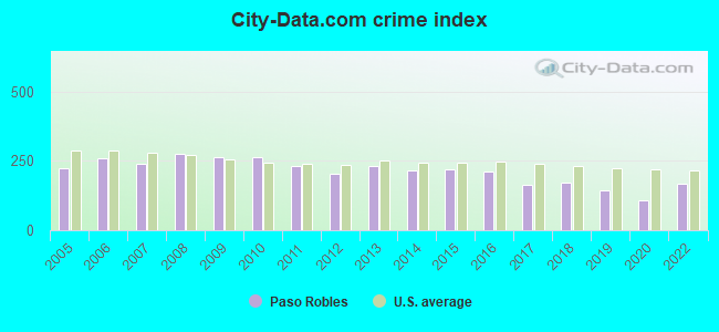
| City-Data.com crime index | 261.6 | 263.8 | 232.9 | 203.4 | 232.3 | 216.6 | 217.5 | 211.0 | 162.7 | 171.1 | 145.4 | 107.6 | 165.7 |
The City-Data.com crime index weighs serious crimes and violent crimes more heavily. Higher means more crime, U.S. average is 246.1. It adjusts for the number of visitors and daily workers commuting into cities.
Crime rate in Paso Robles detailed stats: murders, rapes, robberies, assaults, burglaries, thefts, arson
Full-time law enforcement employees in 2021, including police officers: 50 (33 officers - 30 male; 3 female).
| Officers per 1,000 residents here: | 1.04 |
| California average: | 2.30 |
 Recent articles from our blog. Our writers, many of them Ph.D. graduates or candidates, create easy-to-read articles on a wide variety of topics.
Current Local Time: PST time zone
Elevation: 721 feet
Land area: 991.9 square miles.
Population density: 43 people per square mile (very low).
| Paso Robles CCD: | 1.0% ($1,668) |
| California: | 0.8% ($1,564) |
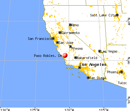
Nearest city with pop. 50,000+: Santa Maria, CA  (49.6 miles , pop. 77,423).
Nearest city with pop. 200,000+: Fresno, CA (91.6 miles , pop. 427,652).
Nearest city with pop. 1,000,000+: Los Angeles, CA (167.8 miles , pop. 3,694,820).
Nearest cities:
), ), ), )Latitude: 35.65 N, Longitude: 120.64 W
Area code: 805

Paso Robles tourist attractions:
- Castoro Cellars
- Breakaway Tours & Event Planning
- Hotel Cheval
- Children's Museum at the Paso Robles Volunteer Firehouse
- Eberle Winery
- Edward Sellers
- EOS Estate Winery at Arciero Vineyards
- Meridian Vineyards
- JUSTIN Vineyards and Winery
- Tobin James Cellars
- Wine Wrangler
- Zenaida Cellars
- Vina Robles
- Holiday Inn Express & Suites
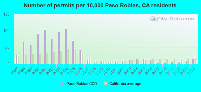
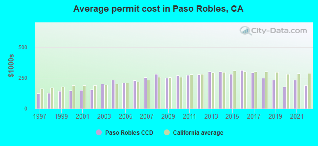
Single-family new house construction building permits:
- 2022: 67 buildings, average cost: $192,400
- 2021: 39 buildings, average cost: $232,500
- 2020: 28 buildings, average cost: $179,400
- 2019: 24 buildings, average cost: $235,300
- 2018: 21 buildings, average cost: $250,800
- 2017: 21 buildings, average cost: $291,500
- 2016: 44 buildings, average cost: $312,300
- 2015: 61 buildings, average cost: $279,700
- 2014: 61 buildings, average cost: $299,600
- 2013: 48 buildings, average cost: $299,500
- 2012: 42 buildings, average cost: $277,700
- 2011: 42 buildings, average cost: $275,300
- 2010: 14 buildings, average cost: $269,300
- 2009: 32 buildings, average cost: $248,300
- 2008: 18 buildings, average cost: $283,000
- 2007: 43 buildings, average cost: $254,600
- 2006: 174 buildings, average cost: $228,700
- 2005: 285 buildings, average cost: $210,400
- 2004: 431 buildings, average cost: $233,100
- 2003: 394 buildings, average cost: $201,700
- 2002: 305 buildings, average cost: $154,700
- 2001: 421 buildings, average cost: $149,200
- 2000: 371 buildings, average cost: $145,700
- 1999: 231 buildings, average cost: $141,100
- 1998: 269 buildings, average cost: $127,100
- 1997: 108 buildings, average cost: $123,000
| Here: | 3.6% |
| California: | 5.1% |
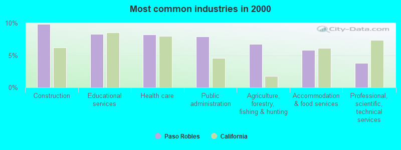
- Construction (9.9%)
- Educational services (8.3%)
- Health care (8.2%)
- Public administration (7.9%)
- Agriculture, forestry, fishing & hunting (6.7%)
- Accommodation & food services (5.8%)
- Professional, scientific, technical services (3.8%)
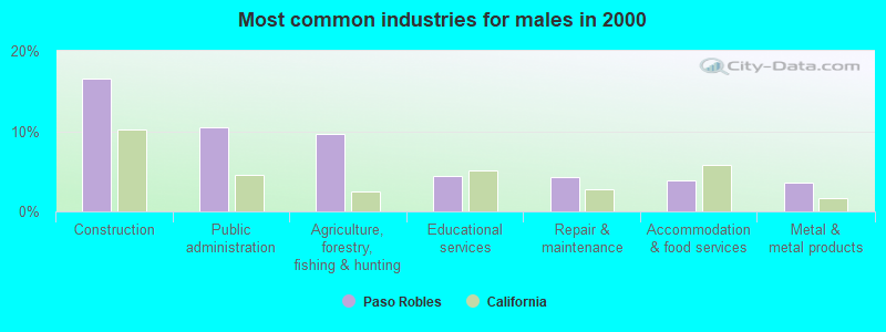
- Construction (16.5%)
- Public administration (10.5%)
- Agriculture, forestry, fishing & hunting (9.7%)
- Educational services (4.4%)
- Repair & maintenance (4.2%)
- Accommodation & food services (3.9%)
- Metal & metal products (3.6%)
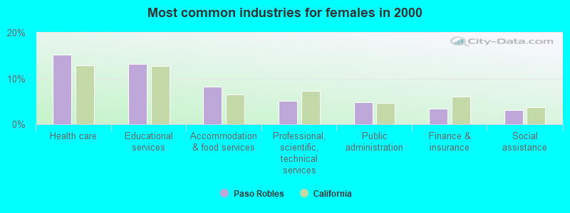
- Health care (15.1%)
- Educational services (13.1%)
- Accommodation & food services (8.2%)
- Professional, scientific, technical services (5.2%)
- Public administration (4.8%)
- Finance & insurance (3.3%)
- Social assistance (3.1%)
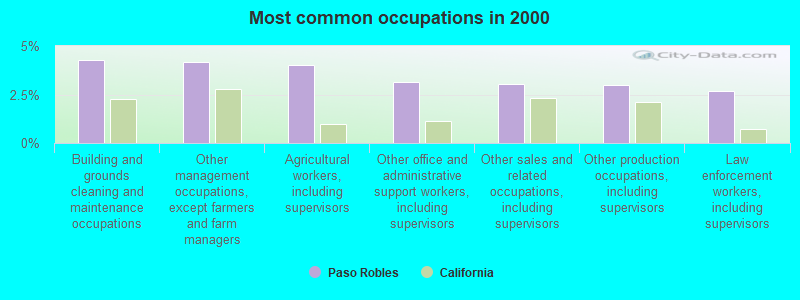
- Building and grounds cleaning and maintenance occupations (4.3%)
- Other management occupations, except farmers and farm managers (4.2%)
- Agricultural workers, including supervisors (4.0%)
- Other office and administrative support workers, including supervisors (3.2%)
- Other sales and related occupations, including supervisors (3.1%)
- Other production occupations, including supervisors (3.0%)
- Law enforcement workers, including supervisors (2.7%)
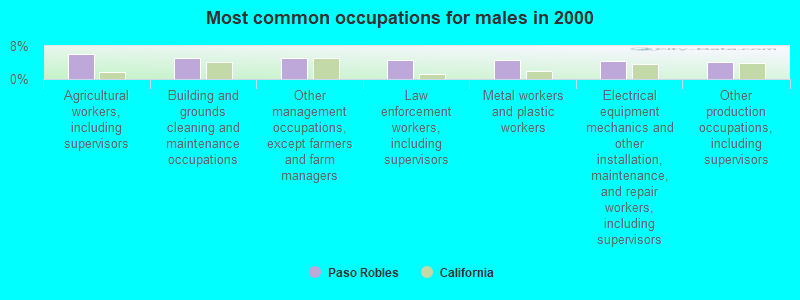
- Agricultural workers, including supervisors (6.1%)
- Building and grounds cleaning and maintenance occupations (5.1%)
- Other management occupations, except farmers and farm managers (5.0%)
- Law enforcement workers, including supervisors (4.5%)
- Metal workers and plastic workers (4.5%)
- Electrical equipment mechanics and other installation, maintenance, and repair workers, including supervisors (4.4%)
- Other production occupations, including supervisors (4.1%)
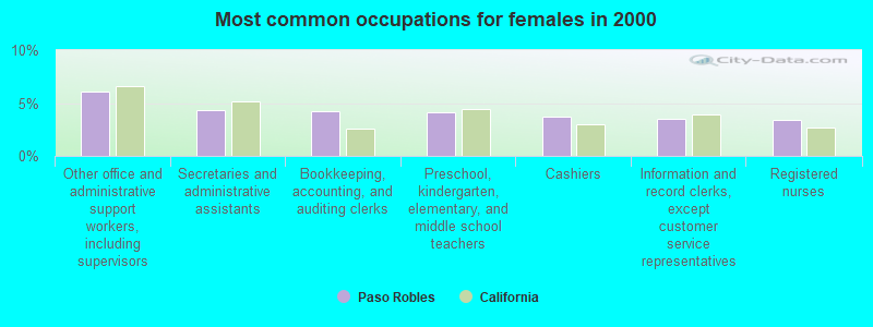
- Other office and administrative support workers, including supervisors (6.1%)
- Secretaries and administrative assistants (4.4%)
- Bookkeeping, accounting, and auditing clerks (4.2%)
- Preschool, kindergarten, elementary, and middle school teachers (4.1%)
- Cashiers (3.7%)
- Information and record clerks, except customer service representatives (3.5%)
- Registered nurses (3.4%)
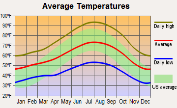
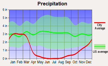
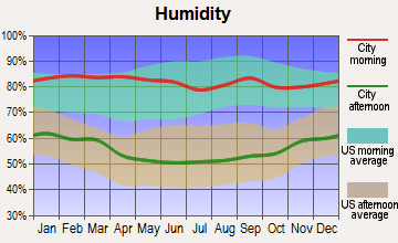
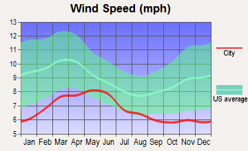
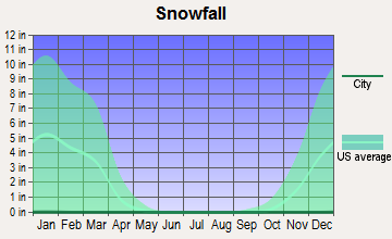
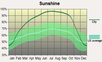
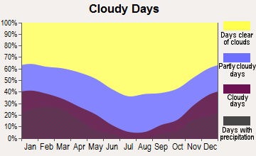
Average climate in Paso Robles, California
Based on data reported by over 4,000 weather stations
(lower is better)
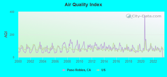
Air Quality Index (AQI) level in 2022 was 74.6. This is about average.
| City: | 74.6 |
| U.S.: | 72.6 |
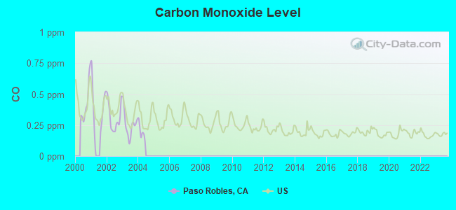
Carbon Monoxide (CO) [ppm] level in 2003 was 0.257. This is about average. Closest monitor was 10.9 miles away from the city center.
| City: | 0.257 |
| U.S.: | 0.251 |
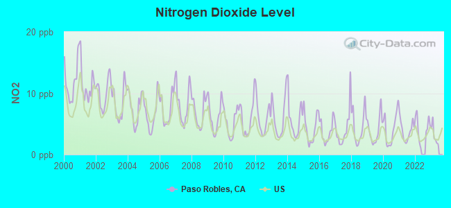
Nitrogen Dioxide (NO2) [ppb] level in 2022 was 4.36. This is about average. Closest monitor was 10.7 miles away from the city center.
| City: | 4.36 |
| U.S.: | 5.11 |
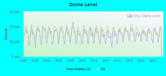
Ozone [ppb] level in 2022 was 29.1. This is about average. Closest monitor was 1.8 miles away from the city center.
| City: | 29.1 |
| U.S.: | 33.3 |
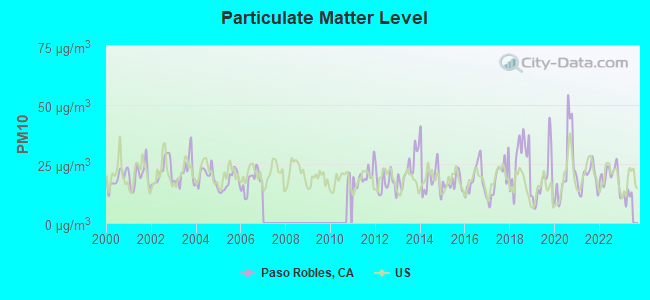
Particulate Matter (PM10) [µg/m3] level in 2022 was 20.0. This is about average. Closest monitor was 2.5 miles away from the city center.
| City: | 20.0 |
| U.S.: | 19.2 |
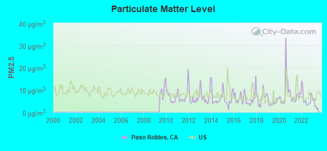
Particulate Matter (PM2.5) [µg/m3] level in 2022 was 6.18. This is better than average. Closest monitor was 10.7 miles away from the city center.
| City: | 6.18 |
| U.S.: | 8.11 |
Earthquake activity:
Paso Robles-area historical earthquake activity is significantly above California state average. It is 7622% greater than the overall U.S. average.On 7/21/1952 at 11:52:14, a magnitude 7.7 (7.7 UK, Class: Major, Intensity: VIII - XII) earthquake occurred 102.8 miles away from Paso Robles center, causing $50,000,000 total damage
On 11/4/1927 at 13:51:53, a magnitude 7.5 (7.5 UK) earthquake occurred 55.3 miles away from Paso Robles center
On 4/18/1906 at 13:12:21, a magnitude 7.9 (7.9 UK) earthquake occurred 208.7 miles away from the city center, causing $524,000,000 total damage
On 10/18/1989 at 00:04:15, a magnitude 7.1 (6.5 MB, 7.1 MS, 6.9 MW, 7.0 ML) earthquake occurred 119.1 miles away from Paso Robles center, causing 62 deaths (62 shaking deaths) and 3757 injuries, causing $1,305,032,704 total damage
On 6/28/1992 at 11:57:34, a magnitude 7.6 (6.2 MB, 7.6 MS, 7.3 MW, Depth: 0.7 mi) earthquake occurred 254.0 miles away from Paso Robles center, causing 3 deaths (1 shaking deaths, 2 other deaths) and 400 injuries, causing $100,000,000 total damage and $40,000,000 insured losses
On 5/2/1983 at 23:42:37, a magnitude 6.7 (6.2 MB, 6.5 MS, 6.5 MW, 6.7 ML, Class: Strong, Intensity: VII - IX) earthquake occurred 43.7 miles away from Paso Robles center, causing $31,000,000 total damage
Magnitude types: body-wave magnitude (MB), local magnitude (ML), surface-wave magnitude (MS), moment magnitude (MW)
Natural disasters:
The number of natural disasters in San Luis Obispo County (20) is greater than the US average (15).Major Disasters (Presidential) Declared: 14
Emergencies Declared: 2
Causes of natural disasters: Floods: 14, Storms: 7, Winter Storms: 7, Mudslides: 5, Landslides: 3, Drought: 1, Earthquake: 1, Fire: 1, Freeze: 1, Hurricane: 1, Tornado: 1, Other: 1 (Note: some incidents may be assigned to more than one category).
Main business address for: HERITAGE OAKS BANCORP (STATE COMMERCIAL BANKS).
Hospitals and medical centers near Paso Robles:
- TWIN CITIES COMMUNITY HOSPITAL Acute Care Hospitals (about 8 miles away; TEMPLETON, CA)
- VINEYARD HILLS HEALTH CENTER (Nursing Home, about 8 miles away; TEMPLETON, CA)
- TEMPLETON DIALYSIS (Dialysis Facility, about 8 miles away; TEMPLETON, CA)
- CENTRAL COAST NEUROBEHAVIOR CENTER - ADOLESCENTS (Hospital, about 12 miles away; ATASCADERO, CA)
- DANISH CARE CENTER (Nursing Home, about 14 miles away; ATASCADERO, CA)
- COUNTRY CARE CONVALESCENT HOSPITAL (Nursing Home, about 16 miles away; ATASCADERO, CA)
Airports located in Paso Robles:
- Paso Robles Municipal Airport (PRB) (Runways: 3, Air Taxi Ops: 2,500, Itinerant Ops: 11,000, Local Ops: 19,500, Military Ops: 1,250)
- Camatta Ranch Airstrip Airport (74CN) (Runways: 1)
- Oak Country Ranch Airport (33CL) (Runways: 1)
College/University in Paso Robles:
Colleges/universities with over 2000 students nearest to Paso Robles:
- Cuesta College (about 23 miles; San Luis Obispo, CA; Full-time enrollment: 6,518)
- California Polytechnic State University-San Luis Obispo (about 25 miles; San Luis Obispo, CA; FT enrollment: 17,345)
- Allan Hancock College (about 51 miles; Santa Maria, CA; FT enrollment: 6,639)
- West Hills College-Lemoore (about 64 miles; Lemoore, CA; FT enrollment: 2,314)
- Taft College (about 75 miles; Taft, CA; FT enrollment: 2,121)
- San Joaquin Valley College-Visalia (about 85 miles; Visalia, CA; FT enrollment: 2,386)
- College of the Sequoias (about 88 miles; Visalia, CA; FT enrollment: 6,982)
Public high schools in Paso Robles:
- PASO ROBLES HIGH (Students: 1,400, Location: 801 NIBLICK RD., Grades: 9-12)
- INDEPENDENCE HIGH (Students: 60, Location: 812 NIBLICK RD., Grades: 9-12)
- LIBERTY HIGH (CONTINUATION) (Students: 37, Location: 810 NIBLICK RD., Grades: 9-12)
Private high school in Paso Robles:
Biggest public elementary/middle schools in Paso Robles:
- DANIEL LEWIS MIDDLE (Students: 724, Location: 900 CRESTON RD., Grades: 6-8)
- GEORGE H. FLAMSON MIDDLE (Students: 672, Location: 655 24TH ST., Grades: 6-8)
- BAUER/SPECK ELEMENTARY (Students: 326, Location: 401 17TH ST., Grades: KG-5)
- VIRGINIA PETERSON ELEMENTARY (Students: 318, Location: 2501 BEECHWOOD DR., Grades: KG-5)
- WINIFRED PIFER ELEMENTARY (Students: 315, Location: 1350 CRESTON RD., Grades: KG-5)
- GEORGIA BROWN ELEMENTARY (Students: 313, Location: 525 36TH ST., Grades: KG-5)
- PAT BUTLER ELEMENTARY (Students: 294, Location: 700 NICKLAUS ST., Grades: KG-5)
- KERMIT KING ELEMENTARY (Students: 259, Location: 700 SCHHOUSE CIR., Grades: KG-5)
- PASO ROBLES INDEPENDENT STUDY CENTER (Students: 94, Location: 2405 SPRING ST., Grades: KG-8)
- CAPPY CULVER ELEMENTARY (Students: 77, Location: 11011 HERITAGE RANCH LOOP RD., Grades: KG-8)
Private elementary/middle schools in Paso Robles:
Points of interest:
Notable locations in Paso Robles: Sprague Camp (A), Varnum Ranch (B), Taylor Ranch (C), Spring Ranch (D), Shandon Pump Station (E), Sacramento Ranch (F), Ludeke Ranch (G), Kester Ranch (H), Jack Ranch (I), Iverson Ranch (J), Hillman Ranch (K), Jackson and Reinhert Ranch (L), Kentucky Ranch (M), French Camp (N), Camatta Ranch (O), Nacimiento Ranch (P), Paso Robles Golf and Country Club (Q), Hope Farms Winery (R), Hunter Ranch Golf Course (S), Estrella River Winery (T). Display/hide their locations on the map
Main business address in Paso Robles: HERITAGE OAKS BANCORP (A). Display/hide its location on the map
Churches in Paso Robles include: Mennonite Church (A), Trinity Lutheran Church (B), Mission San Miguel Arcángel (C), Christian Life Center (D), First Church of God (E), Full Gospel Church (F), Northside Church of Christ (G), San Miguel Assembly of God Church (H), Second Baptist Church (I). Display/hide their locations on the map
Cemeteries: Paso Robles District Cemetery (1), Adelaida Cemetery (2), Clark Memorial Park (3), Shandon Cemetery (4). Display/hide their locations on the map
Lakes and reservoirs: Poso Ortega (A), Poison Water Pond (B), Kerr Lake (C), Twisselmann Lake (D), Long Lake (E), O'Brien Lake (F), Lake Nacimiento (G). Display/hide their locations on the map
Rivers and creeks: Gulch House Creek (A), Franklin Creek (B), Estrella River (C), Navajo Creek (D), Dry Creek (E), Dip Creek (F), Cholame Creek (G), Little Burnett Creek (H), Cantinas Creek (I). Display/hide their locations on the map
Parks in Paso Robles include: California Mid-State Fairground (1), Garelli Field (2), Pioneer Park (3), San Miguel Park (4), Barney Schwartz Park (5), Crawford W Clarke Memorial Park (6), Downtown City Park (7), Paso Robles Municipal Pool (8), Caso Robles Park (9). Display/hide their locations on the map
Hotels: Adelaide Inn (1215 Ysabel Street) (1), Avalon Motel (3231 Spring Street) (2), Best Western Black Oak Motor L (1135 24th Street) (3), Budget Inn of Paso Robles (2745 Spring Street) (4). Display/hide their approximate locations on the map
Courts: California State - Superior Court- Paso Robles Branch- Civil (549 10th Street) (1), San Luis Obispo County - Superior Court- County Government Center- Paso Robles Branch- Crim (549 10th Street) (2). Display/hide their approximate locations on the map
Birthplace of: Elodie Keene - Film director, Jason Botts - 2005 Major League Baseball player (Texas Rangers, born: Jul 26, 1980), Christine Clayburg - Actor, Elena Verdugo - Actor, Hal Rhyne - Baseball player, John Seedborg - Football player.
Drinking water stations with addresses in Paso Robles and their reported violations in the past:
LINKS AT VISTA DEL HOMBRE, THE (Population served: 25, Groundwater):Past monitoring violations:
- 10 routine major monitoring violations
Drinking water stations with addresses in Paso Robles that have no violations reported:
- PASO ROBLES RV RANCH (Population served: 105, Primary Water Source Type: Groundwater)
- TRI COUNTIES CLUB (Population served: 87, Primary Water Source Type: Groundwater)
- HUNTER RANCH GOLF COURSE (Population served: 50, Primary Water Source Type: Groundwater)
| This place: | 2.7 people |
| California: | 2.9 people |
| This place: | 71.9% |
| Whole state: | 68.7% |
| This place: | 7.5% |
| Whole state: | 7.2% |
Likely homosexual households (counted as self-reported same-sex unmarried-partner households)
- Lesbian couples: 0.5% of all households
- Gay men: 0.3% of all households
| This place: | 12.5% |
| Whole state: | 14.2% |
| This place: | 6.1% |
| Whole state: | 6.3% |
People in group quarters in Paso Robles in 2010:
- 114 people in other noninstitutional facilities
- 35 people in group homes intended for adults
- 19 people in workers' group living quarters and job corps centers
- 15 people in residential treatment centers for adults
- 12 people in group homes for juveniles (non-correctional)
- 11 people in military barracks and dormitories (nondisciplinary)
People in group quarters in Paso Robles in 2000:
- 784 people in training schools for juvenile delinquents
- 80 people in other noninstitutional group quarters
- 65 people in homes for the mentally retarded
- 50 people in nursing homes
- 9 people in religious group quarters
- 8 people in unknown juvenile institutions
- 6 people in agriculture workers' dormitories on farms
Banks with most branches in Paso Robles (2011 data):
- Rabobank, National Association: Creston Road at 705 Golden Hill Road, branch established on 1990/09/17; Paso Robles Branch at 845 Spring Street, branch established on 1978/02/15. Info updated 2011/01/27: Bank assets: $11,745.0 mil, Deposits: $8,446.0 mil, headquarters in Roseville, CA, positive income, Agricultural Specialization, 124 total offices, Holding Company: Cooperatieve Centrale Raiffeisen-Boerenleenbank B.A., "rabobank Nederland
- Heritage Oaks Bank: Woodland Plaza Branch at 400 South River Road, branch established on 1994/06/05; at 545 Twelfth Street, branch established on 1983/01/19. Info updated 2012/01/06: Bank assets: $982.9 mil, Deposits: $786.8 mil, local headquarters, positive income, Commercial Lending Specialization, 14 total offices, Holding Company: Heritage Oaks Bancorp
- Wells Fargo Bank, National Association: Paso Robles Branch at 546 Spring St, branch established on 1981/11/17. Info updated 2011/04/05: Bank assets: $1,161,490.0 mil, Deposits: $905,653.0 mil, headquarters in Sioux Falls, SD, positive income, 6395 total offices, Holding Company: Wells Fargo & Company
- Santa Barbara Bank & Trust, National Association: Paso Robles Spring Street Branch, at 1207 Spring Street, branch established on 2006/11/13. Info updated 2011/06/09: Bank assets: $5,847.9 mil, Deposits: $4,684.3 mil, headquarters in Santa Barbara, CA, positive income, Commercial Lending Specialization, 48 total offices, Holding Company: Sb Acquisition Company, Llc
- Coast National Bank: Paso Robles Branch at 2138 Spring Street, Suite A, branch established on 2005/03/16. Info updated 2006/11/03: Bank assets: $132.2 mil, Deposits: $124.4 mil, headquarters in San Luis Obispo, CA, negative income in the last year, Commercial Lending Specialization, 5 total offices, Holding Company: Coast Bancorp
- JPMorgan Chase Bank, National Association: Niblick Road Branch at 148 Niblick Road, branch established on 1997/07/01. Info updated 2011/11/10: Bank assets: $1,811,678.0 mil, Deposits: $1,190,738.0 mil, headquarters in Columbus, OH, positive income, International Specialization, 5577 total offices, Holding Company: Jpmorgan Chase & Co.
- U.S. Bank National Association: Paso Robles Albertsons Branch at 189 Niblick Rd, branch established on 2001/03/09. Info updated 2012/01/30: Bank assets: $330,470.8 mil, Deposits: $236,091.5 mil, headquarters in Cincinnati, OH, positive income, 3121 total offices, Holding Company: U.S. Bancorp
- Mission Community Bank: Paso Robles Branch at 1240 Spring Street, branch established on 1990/02/20. Info updated 2011/12/05: Bank assets: $454.8 mil, Deposits: $413.1 mil, headquarters in San Luis Obispo, CA, negative income in the last year, Commercial Lending Specialization, 9 total offices, Holding Company: Scj, Inc.
- Citibank, National Association: 1601 Spring St Branch at 1601 Spring St, branch established on 1905/01/01. Info updated 2012/01/10: Bank assets: $1,288,658.0 mil, Deposits: $882,541.0 mil, headquarters in Sioux Falls, SD, positive income, International Specialization, 1048 total offices, Holding Company: Citigroup Inc.
For population 15 years and over in Paso Robles:
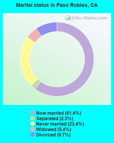
- Never married: 23.4%
- Now married: 61.4%
- Separated: 2.3%
- Widowed: 5.4%
- Divorced: 9.7%
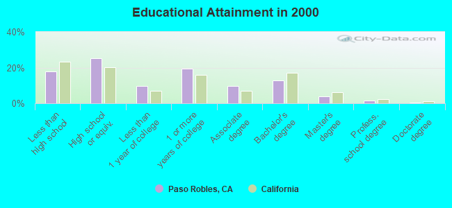
For population 25 years and over in Paso Robles:
- High school or higher: 82.1%
- Bachelor's degree or higher: 18.2%
- Graduate or professional degree: 5.5%
- Unemployed: 5.9%
- Mean travel time to work (commute): 23.6 minutes
| Here: | 12.5 |
| California average: | 16.1 |
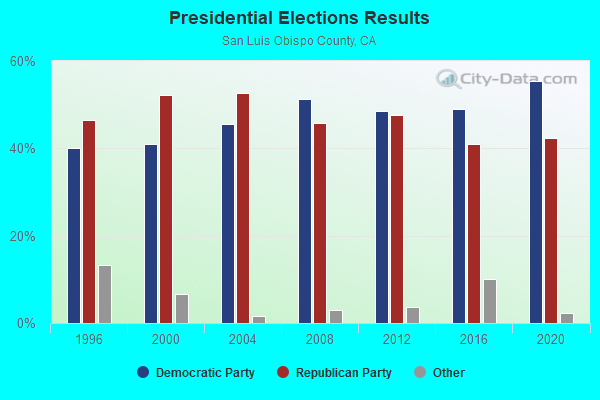
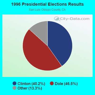
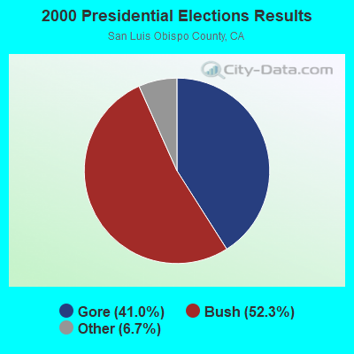
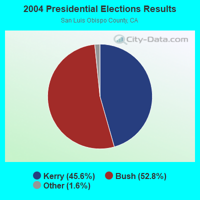
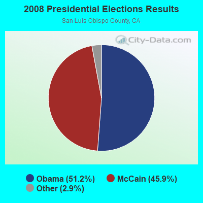
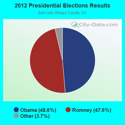
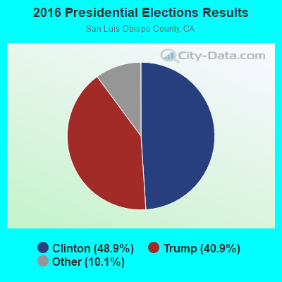
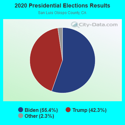
Graphs represent county-level data. Detailed 2008 Election Results
Religion statistics for Paso Robles, CA (based on San Luis Obispo County data)
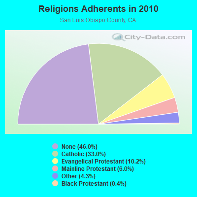
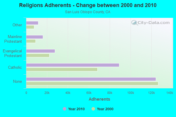
| Religion | Adherents | Congregations |
|---|---|---|
| Catholic | 89,075 | 17 |
| Evangelical Protestant | 27,483 | 138 |
| Mainline Protestant | 16,099 | 56 |
| Other | 11,530 | 47 |
| Black Protestant | 1,078 | 3 |
| Orthodox | 205 | 2 |
| None | 124,167 | - |
Food Environment Statistics:
| San Luis Obispo County: | 2.29 / 10,000 pop. |
| California: | 2.14 / 10,000 pop. |
| This county: | 0.04 / 10,000 pop. |
| California: | 0.04 / 10,000 pop. |
| This county: | 0.69 / 10,000 pop. |
| California: | 0.62 / 10,000 pop. |
| San Luis Obispo County: | 2.22 / 10,000 pop. |
| California: | 1.49 / 10,000 pop. |
| Here: | 11.00 / 10,000 pop. |
| California: | 7.42 / 10,000 pop. |
| This county: | 6.1% |
| State: | 7.3% |
| Here: | 21.5% |
| California: | 21.3% |
| San Luis Obispo County: | 14.5% |
| California: | 17.9% |
6.17% of this county's 2020 resident taxpayers moved to other counties in 2021 ($68,140 average adjusted gross income)
| Here: | 6.17% |
| California average: | 6.14% |
0.02% of residents moved to foreign countries ($212 average AGI)
San Luis Obispo County: 0.02% California average: 0.02%
Top counties to which taxpayers relocated from this county between 2020 and 2021:
| to Santa Barbara County, CA | |
| to Los Angeles County, CA | |
| to San Diego County, CA |
| Businesses in Paso Robles, CA | ||||
| Name | Count | Name | Count | |
|---|---|---|---|---|
| AT&T | 1 | Lane Furniture | 1 | |
| Albertsons | 1 | Lowe's | 1 | |
| Applebee's | 1 | MasterBrand Cabinets | 5 | |
| Bed Bath & Beyond | 1 | McDonald's | 3 | |
| Best Western | 1 | Motel 6 | 1 | |
| Budget Car Rental | 1 | New Balance | 1 | |
| CVS | 1 | Nike | 4 | |
| Carl\s Jr. | 2 | OfficeMax | 1 | |
| Chevrolet | 1 | Panda Express | 1 | |
| Cold Stone Creamery | 1 | Payless | 1 | |
| Curves | 1 | Penske | 1 | |
| Dennys | 1 | Pier 1 Imports | 1 | |
| Domino's Pizza | 1 | Quiznos | 2 | |
| El Pollo Loco | 1 | RadioShack | 1 | |
| Famous Footwear | 1 | Rite Aid | 2 | |
| FedEx | 9 | Sears | 1 | |
| Ford | 1 | Staples | 1 | |
| GNC | 2 | Starbucks | 6 | |
| GameStop | 1 | Subway | 6 | |
| Goodwill | 1 | T-Mobile | 3 | |
| H&R Block | 3 | Taco Bell | 2 | |
| Hilton | 1 | Target | 1 | |
| Holiday Inn | 1 | Travelodge | 1 | |
| JCPenney | 1 | True Value | 1 | |
| Jamba Juice | 1 | U-Haul | 3 | |
| Jones New York | 2 | UPS | 6 | |
| KFC | 1 | Vans | 3 | |
| Kohl's | 1 | Vons | 1 | |
| La Quinta | 1 | Walmart | 1 | |
| La-Z-Boy | 1 | Wendy's | 1 | |
Strongest AM radio stations in Paso Robles:
- KPRL (1230 AM; 1 kW; PASO ROBLES, CA; Owner: DOUGLAS M. DAGGS, EXECUTOR)
- KGDP (660 AM; 50 kW; ORCUTT, CA; Owner: RADIO REPRESENTATIVES, INC.)
- KMJ (580 AM; 50 kW; FRESNO, CA; Owner: INFINITY RADIO OPERATIONS INC.)
- KERI (1180 AM; 50 kW; WASCO-GREENACRES, CA; Owner: KWSO, INC.)
- KXTK (1280 AM; 10 kW; ARROYO GRANDE, CA; Owner: PAMPLIN BROADCASTING, INC.)
- KWRU (940 AM; 50 kW; FRESNO, CA)
- KLFF (890 AM; 5 kW; ARROYO GRANDE, CA; Owner: JERRY J. COLLINS)
- KJDJ (1030 AM; 2 kW; SAN LUIS OBISPO, CA; Owner: PADRE SERRA COMMUNICATIONS, INC)
- KMBX (700 AM; 10 kW; SOLEDAD, CA; Owner: ENTRAVISION HOLDINGS, LLC)
- KYAA (1200 AM; 25 kW; SOQUEL, CA; Owner: PEOPLE'S RADIO, INC.)
- KCBC (770 AM; 50 kW; RIVERBANK, CA; Owner: KIERTRON, INC.)
- KNBR (680 AM; 50 kW; SAN FRANCISCO, CA; Owner: KNBR LICO, INC.)
- KGO (810 AM; 50 kW; SAN FRANCISCO, CA; Owner: KGO-AM RADIO, INC.)
Strongest FM radio stations in Paso Robles:
- KLUN (103.1 FM; PASO ROBLES, CA; Owner: LAZER BROADCASTING CORPORATION)
- KXDZ (100.5 FM; TEMPLETON, CA; Owner: MAPLETON COMMUNICATIONS, LLC)
- KSTT-FM (101.3 FM; LOS OSOS-BAYWOOD PAR, CA; Owner: CLEAR CHANNEL BROADCASTING LICENSES, INC.)
- KSLY-FM (96.1 FM; SAN LUIS OBISPO, CA; Owner: CLEAR CHANNEL BROADCASTING LICENSES, INC.)
- KKAL (99.7 FM; MORRO BAY, CA; Owner: SALISBURY BROADCASTING CORP.)
- KZOZ (93.3 FM; SAN LUIS OBISPO, CA; Owner: AMERICAN GENERAL MEDIA-TEXAS, INC.)
- KWSR (92.5 FM; PASO ROBLES, CA; Owner: LAGNIAPPE BROADCASTING, INC)
- KKJG (98.1 FM; SAN LUIS OBISPO, CA; Owner: AGM SAN LUIS OBISPO, L.P.)
- KWWV (106.1 FM; SANTA MARGARITA, CA; Owner: SALISBURY RADIO LLC)
- K209CE (89.7 FM; SAN LUIS OBISPO, CA; Owner: FAMILY STATIONS, INC.)
- KLRM (97.1 FM; SAN LUIS OBISPO, CA; Owner: GTM SAN LUIS OBISPO)
- KIQO (104.5 FM; ATASCADERO, CA; Owner: AMERICAN GENERAL MEDIA OF TEXAS, INC)
- KCBX (90.1 FM; SAN LUIS OBISPO, CA; Owner: KCBX, INC.)
- KLVH (88.5 FM; SAN LUIS OBISPO, CA; Owner: EDUCATIONAL MEDIA FOUNDATION)
- K213CO (90.5 FM; SAN LUIS OBISPO, CA; Owner: PENSACOLA CHRISTIAN COLLEGE, INC.)
- KBDH (91.7 FM; SAN ARDO, CA; Owner: PATAPHYSICAL BROADCASTING FOUNDATION)
- K206CC (89.1 FM; LOCKWOOD, CA; Owner: PRUNEDALE EDUC. F'DATION/CENTRAL CA)
- KLMM (94.1 FM; MORRO BAY, CA; Owner: LAZER BROADCASTING CORPORATION)
- KRKC-FM (102.1 FM; KING CITY, CA; Owner: KING CITY COMMUNICATIONS CORPORATION)
- KURQ (107.3 FM; GROVER BEACH, CA; Owner: CLEAR CHANNEL BROADCASTING LICENSES, INC.)
TV broadcast stations around Paso Robles:
- K17GD (Channel 17; PASO ROBLES, CA; Owner: ENTRAVISION HOLDINGS, LLC)
- K19EF (Channel 19; PASO ROBLES, CA; Owner: J B BROADCASTING, INC.)
- KSBY (Channel 6; SAN LUIS OBISPO, CA; Owner: NVG-SANTA BARBARA II, LLC)
- KPXA-LP (Channel 42; SAN LUIS OBISPO, CA; Owner: CAMINO REAL COMMUNICATIONS LLC)
- K28FK (Channel 28; SAN LUIS OBISPO, CA; Owner: ENTRAVISION HOLDINGS, LLC)
- K44DN (Channel 44; PASO ROBLES, CA; Owner: ACKERLEY MEDIA GROUP, INC.)
FCC Registered Antenna Towers: 67 (See the full list of FCC Registered Antenna Towers)
FCC Registered Private Land Mobile Towers: 3 (See the full list of FCC Registered Private Land Mobile Towers in Paso Robles, CA)
FCC Registered Broadcast Land Mobile Towers: 56 (See the full list of FCC Registered Broadcast Land Mobile Towers)
FCC Registered Microwave Towers: 92 (See the full list of FCC Registered Microwave Towers in this town)
FCC Registered Paging Towers: 3 (See the full list of FCC Registered Paging Towers)
FCC Registered Maritime Coast & Aviation Ground Towers: 6 (See the full list of FCC Registered Maritime Coast & Aviation Ground Towers)
FCC Registered Amateur Radio Licenses: 366 (See the full list of FCC Registered Amateur Radio Licenses in Paso Robles)
FAA Registered Aircraft Manufacturers and Dealers: 10 (See the full list of FAA Registered Manufacturers and Dealers in Paso Robles)
FAA Registered Aircraft: 126 (See the full list of FAA Registered Aircraft)
2005 - 2018 National Fire Incident Reporting System (NFIRS) incidents
- Fire incident types reported to NFIRS in Paso Robles, CA
- 81153.4%Outside Fires
- 43328.5%Structure Fires
- 22614.9%Mobile Property/Vehicle Fires
- 483.2%Other
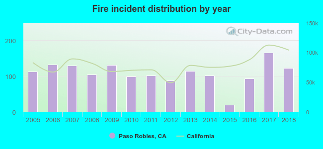 Based on the data from the years 2005 - 2018 the average number of fires per year is 108. The highest number of fires - 166 took place in 2017, and the least - 19 in 2015. The data has a rising trend.
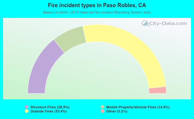 When looking into fire subcategories, the most incidents belonged to: Outside Fires (53.4%), and Structure Fires (28.5%).
Fire-safe hotels and motels in Paso Robles, California:
- Adelaide Motor Inn, 1215 Ysabell Ave, Paso Robles, California 93446 , Phone: (805) 238-2770, Fax: (805) 238-3497
- Best Western Plus Black Oak, 1135 24TH St, Paso Robles, California 93446 , Phone: (805) 238-4740, Fax: (805) 238-0726
- La Bellasera Hotel & Suites, 206 Alexa Ct, Paso Robles, California 93446 , Phone: (805) 238-2834, Fax: (805) 238-2826
- Courtyard By Marriott, 120 S Vine St, Paso Robles, California 93446 , Phone: (805) 239-9700, Fax: (805) 226-9683
- Paso Robles Inn, 1103 Spring St, Paso Robles, California 93446 , Phone: (805) 238-2660, Fax: (805) 238-4707
- La Quinta Inn And Suites Paso Robles, 2615 Buena Vista Dr, Paso Robles, California 93446 , Phone: (805) 239-3004, Fax: (805) 239-3014
- Allegretto Vineyard Resort, 2700 Buena Vista Dr, Paso robles, California 93446 , Phone: (805) 296-3120, Fax: (805) 296-3120
- The Oaks Hotel & Suites, 3000 Riverside Ave, Paso robles, California 93446 , Phone: (805) 237-8700, Fax: (805) 286-4670
- Adelaide Inn, 1215 Ysabel Ave, Paso robles, California 93446 , Phone: (805) 238-2770, Fax: (805) 238-3497
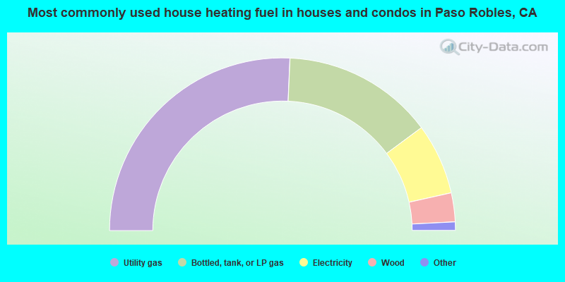
- 51.4%Utility gas
- 28.3%Bottled, tank, or LP gas
- 13.3%Electricity
- 5.4%Wood
- 0.6%Solar energy
- 0.4%Fuel oil, kerosene, etc.
- 0.3%No fuel used
- 0.3%Other fuel
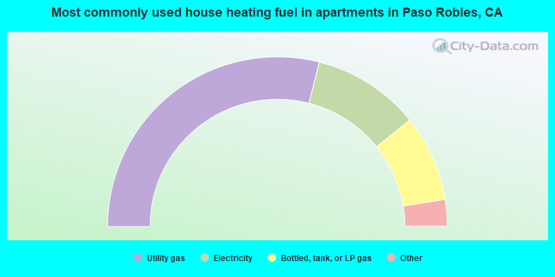
- 58.0%Utility gas
- 20.5%Electricity
- 16.5%Bottled, tank, or LP gas
- 3.6%Wood
- 0.7%No fuel used
- 0.3%Fuel oil, kerosene, etc.
- 0.2%Other fuel
- 0.2%Solar energy
Paso Robles compared to California state average:
- Unemployed percentage below state average.
- Black race population percentage below state average.
- Hispanic race population percentage below state average.
- Foreign-born population percentage significantly below state average.
- Length of stay since moving in significantly above state average.
- Number of rooms per house significantly below state average.
- House age significantly below state average.
Paso Robles on our top lists:
- #25 on the list of "Top 101 cities with largest percentage of males in industries: beverage and tobacco products (population 5,000+)"
- #33 on the list of "Top 101 cities with the largest percentage of people in training schools for juvenile delinquents (population 1,000+)"
- #33 on the list of "Top 101 cities with largest percentage of females in industries: beverage and tobacco products (population 5,000+)"
- #50 on the list of "Top 100 cities with largest land areas (pop. 5,000+)"
- #51 on the list of "Top 101 cities with largest percentage of males in occupations: agricultural workers including supervisors (population 5,000+)"
- #54 on the list of "Top 101 cities with largest percentage of females in industries: farm product raw materials merchant wholesalers (population 5,000+)"
- #87 on the list of "Top 101 cities with largest percentage of females in occupations: agricultural workers including supervisors (population 5,000+)"
- #88 on the list of "Top 101 cities with largest percentage of females in occupations: air transportation workers (population 5,000+)"
- #88 on the list of "Top 101 cities with largest percentage of females in industries: miscellaneous durable goods merchant wholesalers (population 5,000+)"
- #93 on the list of "Top 101 cities with largest percentage of females in occupations: other food preparation and serving workers including supervisors (population 5,000+)"
- #99 on the list of "Top 101 cities with largest percentage of males in occupations: farmers and farm managers (population 5,000+)"
- #4 on the list of "Top 101 counties with the lowest Sulfur Oxides Annual air pollution readings in 2012 (µg/m3)"
- #39 on the list of "Top 101 counties with highest percentage of residents voting for 3rd party candidates in the 2012 Presidential Election (pop. 50,000+)"
- #50 on the list of "Top 101 counties with the lowest number of births per 1000 residents 2007-2013"
- #60 on the list of "Top 101 counties with the lowest Particulate Matter (PM2.5) Annual air pollution readings in 2012 (µg/m3)"
- #74 on the list of "Top 101 counties with the largest increase in the number of births per 1000 residents 2000-2006 to 2007-2013 (pop 50,000+)"

|
|
Total of 108 patent applications in 2008-2024.