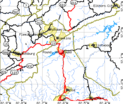
Pound, Virginia
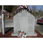
Pound: VFW monument to those killed in service to their country.

Pound: Pound Reservoir, North Fork Dam

Pound: Downtown Pound from the Church on the hill
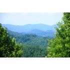
Pound: Mountains in Pound
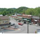
Pound: overlooking downtown Pound
- add
your
Submit your own pictures of this town and show them to the world
- OSM Map
- General Map
- Google Map
- MSN Map
Population change since 2000: -21.8%
 |
| Males: 432 | |
| Females: 420 |
| Median resident age: | 45.4 years |
| Virginia median age: | 39.0 years |
Zip codes: 24279.
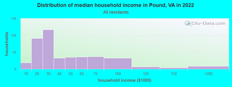
| Pound: | $28,297 |
| VA: | $85,873 |
Estimated per capita income in 2022: $19,438 (it was $14,375 in 2000)
Pound town income, earnings, and wages data
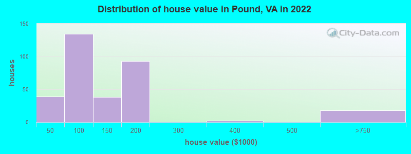
Estimated median house or condo value in 2022: $105,900 (it was $63,500 in 2000)
| Pound: | $105,900 |
| VA: | $365,700 |
Mean prices in 2022: all housing units: $135,917; detached houses: $125,448; mobile homes: $173,326
Median gross rent in 2022: $633.
(31.6% for White Non-Hispanic residents, 100.0% for Black residents)
Detailed information about poverty and poor residents in Pound, VA
Compare current foreclosures near Pound, VA:
| Photo | Address | Area | Beds / Baths | Price | Details |
|---|---|---|---|---|---|

|
#1
Dogwood Ln
Pound, VA 24279
|
- sq. feet
|
- baths - beds |
show details | |

|
#2
Low Wood Dr
Pound, VA 24279
|
- sq. feet
|
- baths - beds |
show details | |

|
#3
Pine Spur Rd
Pound, VA 24279
|
- sq. feet
|
- baths - beds |
show details | |

|
#4
Foothills Rd
Whitesburg, KY 41858
|
1,104 sq. feet
|
1 baths 3 beds |
show details | |

|
#5
Hamilton Town Rd
Coeburn, VA 24230
|
1,800 sq. feet
|
3 baths 3 beds |
show details | |

|
#6
Powhatan Rd
Coeburn, VA 24230
|
1,196 sq. feet
|
2 baths 3 beds |
show details | |

|
#7
Rose Rdg
Clintwood, VA 24228
|
1,773 sq. feet
|
2 baths 3 beds |
show details | |

|
#8
Bernice Dr NE
Norton, VA 24273
|
1,200 sq. feet
|
1 baths 3 beds |
show details | |

|
#9
Parks St
Whitesburg, KY 41858
|
752 sq. feet
|
1 baths 2 beds |
show details | |

|
#10
Bowling Fork Rd
Elkhorn City, KY 41522
|
1,152 sq. feet
|
1 baths 3 beds |
show details |
| Photo | Address | Area | Beds / Baths | Price | Details |
|---|---|---|---|---|---|

|
#11
Craig St NW
Norton, VA 24273
|
1,148 sq. feet
|
1 baths 2 beds |
show details | |

|
#12
Elkhorn Crk
Shelby Gap, KY 41563
|
1,014 sq. feet
|
1 baths 3 beds |
show details | |

|
#13
Caney Newsome Br
Pikeville, KY 41501
|
1,294 sq. feet
|
2 baths 2 beds |
show details | |

|
#14
Atkins Belcher Rd
Elkhorn City, KY 41522
|
1,924 sq. feet
|
1 baths 2 beds |
show details | |

|
#15
Indian Creek Rd
Virgie, KY 41572
|
11,880 sq. feet
|
1 baths 3 beds |
show details | |

|
#16
Helton Hl
Melvin, KY 41650
|
864 sq. feet
|
1 baths 2 beds |
show details | |

|
#17
Marrowbone Creek Rd
Elkhorn City, KY 41522
|
1,188 sq. feet
|
1 baths 3 beds |
show details | |

|
#18
Blaze Br
Jenkins, KY 41537
|
1,600 sq. feet
|
3 baths 3 beds |
show details | |

|
#19
Little Robinson Creek Btm
Virgie, KY 41572
|
1,000 sq. feet
|
1 baths 3 beds |
show details | |

|
#20
School House Holw
Clintwood, VA 24228
|
1,056 sq. feet
|
1 baths 2 beds |
show details |
| Photo | Address | Area | Beds / Baths | Price | Details |
|---|---|---|---|---|---|

|
#21
Dry Creek Rd
Topmost, KY 41862
|
864 sq. feet
|
- baths 2 beds |
show details | |

|
#22
Shop Fork St
Wheelwright, KY 41669
|
- sq. feet
|
- baths - beds |
show details | |

|
#23
Highway 803
Millstone, KY 41838
|
- sq. feet
|
- baths - beds |
show details | |

|
#24
Highway 343
Neon, KY 41840
|
- sq. feet
|
- baths - beds |
show details | |

|
#25
Low Gap Br
Isom, KY 41824
|
- sq. feet
|
- baths - beds |
show details | |

|
#26
Jackson Branch Rd
Elkhorn City, KY 41522
|
- sq. feet
|
- baths - beds |
show details | |

|
#27
Highway 7 N
Whitesburg, KY 41858
|
- sq. feet
|
- baths - beds |
show details | |

|
#28
Highway 343
Mc Roberts, KY 41835
|
- sq. feet
|
- baths - beds |
show details | |

|
#29
Frogtown Rd
Pikeville, KY 41501
|
- sq. feet
|
- baths - beds |
show details | |

|
#30
Tom Biggs Rd
Mc Roberts, KY 41835
|
- sq. feet
|
- baths - beds |
show details |
| Photo | Address | Area | Beds / Baths | Price | Details |
|---|---|---|---|---|---|

|
#31
Henpen Br
Melvin, KY 41650
|
1,248 sq. feet
|
- baths - beds |
show details | |

|
#32
Highway 805
Jenkins, KY 41537
|
- sq. feet
|
- baths - beds |
show details | |

|
#33
James Hall Rd
Melvin, KY 41650
|
- sq. feet
|
- baths - beds |
show details | |

|
#34
Long Fork Marshalls Br
Virgie, KY 41572
|
- sq. feet
|
- baths - beds |
show details | |

|
#35
Cane Holw
Whitesburg, KY 41858
|
- sq. feet
|
- baths - beds |
show details | |

|
#36
Muddy Gut Br
Melvin, KY 41650
|
- sq. feet
|
- baths - beds |
show details | |

|
#37
James Hall Rd
Melvin, KY 41650
|
- sq. feet
|
- baths - beds |
show details | |

|
#38
James Hall Rd
Melvin, KY 41650
|
- sq. feet
|
- baths - beds |
show details | |

|
#39
Highway 7 N
Whitesburg, KY 41858
|
- sq. feet
|
- baths - beds |
show details | |

|
#40
Harrison Newsome Br
Pikeville, KY 41501
|
- sq. feet
|
- baths - beds |
show details |
| Photo | Address | Area | Beds / Baths | Price | Details |
|---|---|---|---|---|---|

|
#41
Crab Orchard Rd
Coeburn, VA 24230
|
- sq. feet
|
- baths - beds |
show details | |

|
#42
Little Fork Rd
Virgie, KY 41572
|
- sq. feet
|
- baths - beds |
show details | |

|
#43
Elkins Br
Partridge, KY 40862
|
- sq. feet
|
- baths - beds |
show details | |

|
#44
Newtown Rd
Appalachia, VA 24216
|
- sq. feet
|
- baths - beds |
show details | |

|
#45
Sycamore Rd
Appalachia, VA 24216
|
- sq. feet
|
- baths - beds |
show details | |

|
#46
Coleman Rd
Elkhorn City, KY 41522
|
- sq. feet
|
- baths - beds |
show details | |

|
#47
Caleb Frk
Weeksbury, KY 41667
|
- sq. feet
|
- baths - beds |
show details | |

|
#48
Marrowbone Creek Rd
Elkhorn City, KY 41522
|
1,664 sq. feet
|
- baths - beds |
show details | |

|
#49
Cane Holw
Whitesburg, KY 41858
|
- sq. feet
|
- baths - beds |
show details | |

|
Check over 1 million property listings on Foreclosure.com!
|
browse all offers | |||


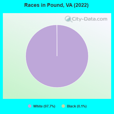
- 91797.7%White alone
- 10.1%Black alone
Races in Pound detailed stats: ancestries, foreign born residents, place of birth
According to our research of Virginia and other state lists, there were 12 registered sex offenders living in Pound, Virginia as of April 28, 2024.
The ratio of all residents to sex offenders in Pound is 79 to 1.
 Recent articles from our blog. Our writers, many of them Ph.D. graduates or candidates, create easy-to-read articles on a wide variety of topics.

 | Moving to VA: Norfolk vs Richmond (57 replies) |
| A short story and outside observations from a long time NoVA resident (55 replies) |
| Do you really like living in a NVA townhouse? (59 replies) |
| I need Raincoat-brand paint please (7 replies) |
| Do you call it Reagan Airport or National Airport? (170 replies) |
| Reckless by Speed, Traffic Ticket... Advice (38 replies) |
Latest news from Pound, VA collected exclusively by city-data.com from local newspapers, TV, and radio stations
Ancestries: American (54.5%), English (20.2%), British (2.6%), Polish (2.1%), Irish (1.9%), German (1.8%).
Current Local Time: EST time zone
Incorporated in 1946
Elevation: 1560 feet
Land area: 2.61 square miles.
Population density: 327 people per square mile (very low).
4 residents are foreign born
| This town: | 0.4% |
| Virginia: | 12.6% |
Median real estate property taxes paid for housing units with mortgages in 2022: $1,087 (0.7%)
Median real estate property taxes paid for housing units with no mortgage in 2022: $588 (0.6%)
Nearest city with pop. 50,000+: Johnson City, TN  (56.1 miles , pop. 55,469).
Nearest city with pop. 200,000+: Fayette, KY (120.9 miles , pop. 260,512).
Nearest city with pop. 1,000,000+: Chicago, IL (423.8 miles , pop. 2,896,016).
Nearest cities:
), ), ), ), Latitude: 37.12 N, Longitude: 82.61 W
Area code: 276
| Here: | 3.6% |
| Virginia: | 2.7% |
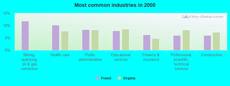
- Mining, quarrying, oil & gas extraction (11.8%)
- Health care (10.2%)
- Public administration (8.4%)
- Educational services (7.9%)
- Finance & insurance (6.3%)
- Professional, scientific, technical services (6.0%)
- Construction (6.0%)
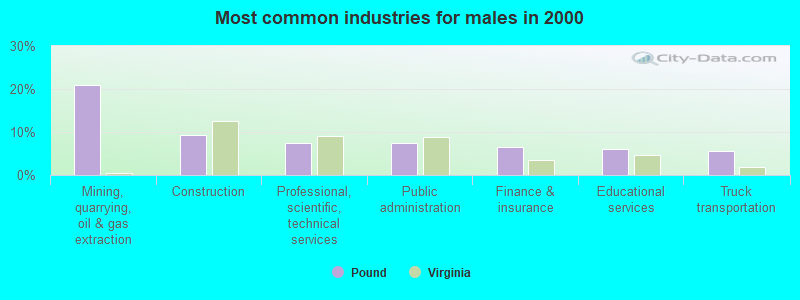
- Mining, quarrying, oil & gas extraction (21.0%)
- Construction (9.3%)
- Professional, scientific, technical services (7.5%)
- Public administration (7.5%)
- Finance & insurance (6.5%)
- Educational services (6.1%)
- Truck transportation (5.6%)
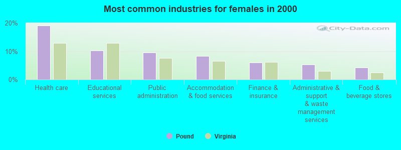
- Health care (19.2%)
- Educational services (10.2%)
- Public administration (9.6%)
- Accommodation & food services (8.4%)
- Finance & insurance (6.0%)
- Administrative & support & waste management services (5.4%)
- Food & beverage stores (4.2%)
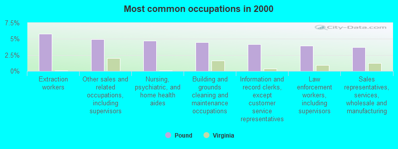
- Extraction workers (5.8%)
- Other sales and related occupations, including supervisors (5.0%)
- Nursing, psychiatric, and home health aides (4.7%)
- Building and grounds cleaning and maintenance occupations (4.5%)
- Information and record clerks, except customer service representatives (4.2%)
- Law enforcement workers, including supervisors (3.9%)
- Sales representatives, services, wholesale and manufacturing (3.7%)
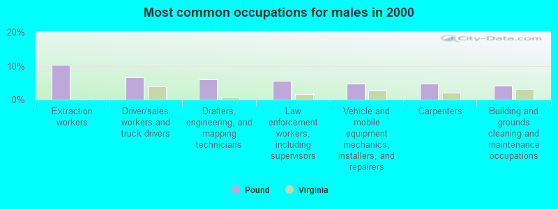
- Extraction workers (10.3%)
- Driver/sales workers and truck drivers (6.5%)
- Drafters, engineering, and mapping technicians (6.1%)
- Law enforcement workers, including supervisors (5.6%)
- Vehicle and mobile equipment mechanics, installers, and repairers (4.7%)
- Carpenters (4.7%)
- Building and grounds cleaning and maintenance occupations (4.2%)

- Nursing, psychiatric, and home health aides (9.6%)
- Information and record clerks, except customer service representatives (7.8%)
- Health technologists and technicians (7.2%)
- Cashiers (6.6%)
- Other sales and related occupations, including supervisors (6.0%)
- Cooks and food preparation workers (4.8%)
- Building and grounds cleaning and maintenance occupations (4.8%)
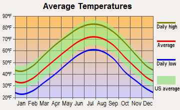
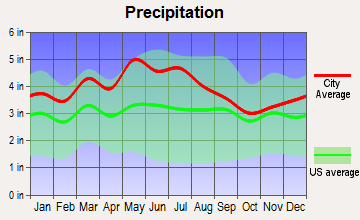
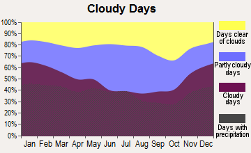
Average climate in Pound, Virginia
Based on data reported by over 4,000 weather stations
|
|


Tornado activity:
Pound-area historical tornado activity is significantly below Virginia state average. It is 78% smaller than the overall U.S. average.
On 4/4/1974, a category F3 (max. wind speeds 158-206 mph) tornado 42.5 miles away from the Pound town center killed one person and injured 4 people and caused between $50,000 and $500,000 in damages.
On 5/18/1995, a category F2 (max. wind speeds 113-157 mph) tornado 24.5 miles away from the town center caused between $50,000 and $500,000 in damages.
Earthquake activity:
Pound-area historical earthquake activity is significantly above Virginia state average. It is 27% greater than the overall U.S. average.On 7/27/1980 at 18:52:21, a magnitude 5.2 (5.1 MB, 4.7 MS, 5.0 UK, 5.2 UK, Class: Moderate, Intensity: VI - VII) earthquake occurred 104.6 miles away from Pound center
On 8/9/2020 at 12:07:37, a magnitude 5.1 (5.1 MW, Depth: 4.7 mi) earthquake occurred 95.1 miles away from Pound center
On 8/23/2011 at 17:51:04, a magnitude 5.8 (5.8 MW, Depth: 3.7 mi) earthquake occurred 262.0 miles away from Pound center
On 11/30/1973 at 07:48:41, a magnitude 4.7 (4.7 MB, 4.6 ML, Class: Light, Intensity: IV - V) earthquake occurred 118.6 miles away from the city center
On 11/23/2006 at 10:42:57, a magnitude 4.3 (4.3 MB) earthquake occurred 35.0 miles away from Pound center
On 9/7/1988 at 02:28:09, a magnitude 4.6 (4.5 MB, 4.6 LG) earthquake occurred 99.0 miles away from Pound center
Magnitude types: regional Lg-wave magnitude (LG), body-wave magnitude (MB), local magnitude (ML), surface-wave magnitude (MS), moment magnitude (MW)
Natural disasters:
The number of natural disasters in Wise County (13) is near the US average (15).Major Disasters (Presidential) Declared: 10
Emergencies Declared: 3
Causes of natural disasters: Floods: 5, Storms: 5, Winter Storms: 4, Hurricanes: 2, Blizzard: 1, Heavy Rain: 1, Ice Storm: 1, Mudslide: 1, Snowfall: 1, Snowstorm: 1, Tornado: 1, Other: 1 (Note: some incidents may be assigned to more than one category).
Hospitals and medical centers in Pound:
Other hospitals and medical centers near Pound:
- WISE CHOICE HOME HEALTH (Home Health Center, about 10 miles away; WISE, VA)
- IN HOME CARE INC (Home Health Center, about 11 miles away; WISE, VA)
- HERITAGE HALL WISE(CLOSED) (Nursing Home, about 11 miles away; WISE, VA)
- NORTON COMMUNITY HOSPITAL HOME HEALTH (Home Health Center, about 11 miles away; WISE, VA)
- ADVANCED HOME CARE (Home Health Center, about 11 miles away; WISE, VA)
- HERITAGE HALL WISE (Nursing Home, about 12 miles away; WISE, VA)
- LETCHER MANOR (Nursing Home, about 12 miles away; WHITESBURG, KY)
Colleges/universities with over 2000 students nearest to Pound:
- Southeast Kentucky Community and Technical College (about 24 miles; Cumberland, KY; Full-time enrollment: 2,196)
- Hazard Community and Technical College (about 33 miles; Hazard, KY; FT enrollment: 2,087)
- Big Sandy Community and Technical College (about 41 miles; Prestonsburg, KY; FT enrollment: 2,660)
- King University (about 45 miles; Bristol, TN; FT enrollment: 2,472)
- Northeast State Community College (about 46 miles; Blountville, TN; FT enrollment: 4,480)
- East Tennessee State University (about 59 miles; Johnson City, TN; FT enrollment: 12,774)
- Tusculum College (about 67 miles; Greeneville, TN; FT enrollment: 2,070)
Public elementary/middle school in Pound:
- J.W. ADAMS COMBINED (Students: 595, Location: 10824 ORBY CANTRELL HWY, Grades: PK-8)
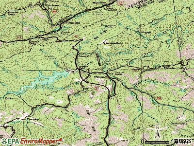
Points of interest:
Notable location: Horse Gap (A). Display/hide its location on the map
Church in Pound: Lone Pine Chapel (A). Display/hide its location on the map
Cemeteries: Gilliam Cemetery (1), Hillman Cemetery (2). Display/hide their locations on the map
Rivers and creeks: South Fork Pound River (A), North Fork Pound River (B), Mill Creek (C), Indian Creek (D), Bold Camp Creek (E). Display/hide their locations on the map
Birthplace of: Napoleon Hill - Motivational writer.
Drinking water stations with addresses in Pound that have no violations reported:
- BOLD CAMP (Population served: 876, Primary Water Source Type: Purch surface water)
| This town: | 2.4 people |
| Virginia: | 2.5 people |
| This town: | 70.1% |
| Whole state: | 67.0% |
| This town: | 5.9% |
| Whole state: | 5.7% |
Likely homosexual households (counted as self-reported same-sex unmarried-partner households)
- Lesbian couples: 0.5% of all households
- Gay men: 0.2% of all households
Banks with branches in Pound (2011 data):
- New Peoples Bank, Inc.: Pound Branch at 11241 Indian Creek Road, branch established on 2006/03/30. Info updated 2007/08/21: Bank assets: $781.6 mil, Deposits: $709.1 mil, headquarters in Honaker, VA, negative income in the last year, Commercial Lending Specialization, 28 total offices, Holding Company: New Peoples Bankshares, Inc.
- First Community Bank: Pound Branch at 8044 Main Street, branch established on 1997/07/25. Info updated 2011/07/12: Bank assets: $2,144.1 mil, Deposits: $1,561.3 mil, headquarters in Bluefield, VA, positive income, Commercial Lending Specialization, 58 total offices, Holding Company: First Community Bancshares, Inc.
- Branch Banking and Trust Company: Pound Branch at 11231 Indian Creek Road, branch established on 1976/05/03. Info updated 2010/03/29: Bank assets: $168,867.6 mil, Deposits: $127,549.5 mil, headquarters in Winston Salem, NC, positive income, Commercial Lending Specialization, 1793 total offices, Holding Company: Bb&T Corporation
For population 15 years and over in Pound:
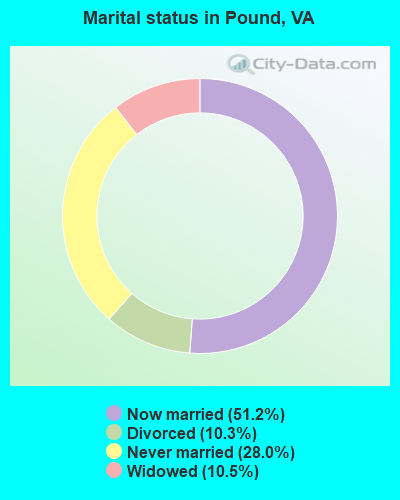
- Never married: 28.0%
- Now married: 51.2%
- Separated: 0.0%
- Widowed: 10.5%
- Divorced: 10.3%
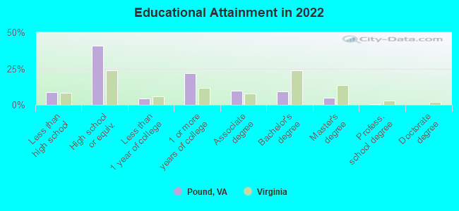
For population 25 years and over in Pound:
- High school or higher: 90.4%
- Bachelor's degree or higher: 14.2%
- Graduate or professional degree: 5.3%
- Unemployed: 9.3%
- Mean travel time to work (commute): 31.4 minutes
| Here: | 7.7 |
| Virginia average: | 12.1 |
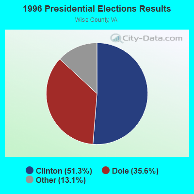

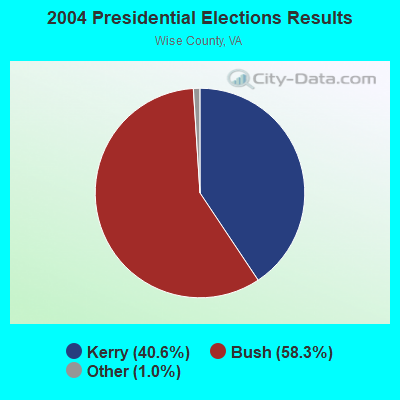
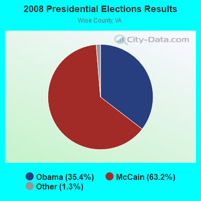
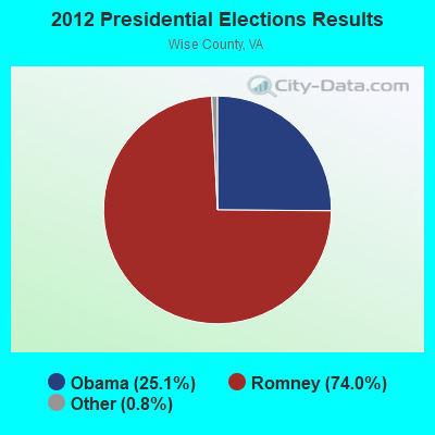
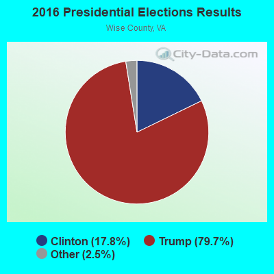
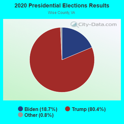
Graphs represent county-level data. Detailed 2008 Election Results
Religion statistics for Pound, VA (based on Wise County data)
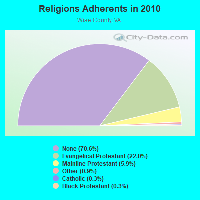
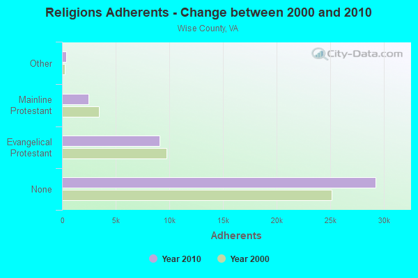
| Religion | Adherents | Congregations |
|---|---|---|
| Evangelical Protestant | 9,101 | 74 |
| Mainline Protestant | 2,455 | 26 |
| Other | 371 | 2 |
| Catholic | 140 | 3 |
| Black Protestant | 119 | 1 |
| None | 29,266 | - |
Food Environment Statistics:
| Wise County: | 2.40 / 10,000 pop. |
| State: | 2.03 / 10,000 pop. |
| Wise County: | 0.96 / 10,000 pop. |
| State: | 1.43 / 10,000 pop. |
| Wise County: | 13.19 / 10,000 pop. |
| State: | 4.03 / 10,000 pop. |
| Here: | 3.84 / 10,000 pop. |
| State: | 7.65 / 10,000 pop. |
| Wise County: | 10.7% |
| State: | 9.3% |
| Wise County: | 30.6% |
| State: | 26.7% |
| This county: | 12.0% |
| Virginia: | 18.6% |
Health and Nutrition:
| Here: | 45.2% |
| Virginia: | 50.6% |
| Pound: | 46.0% |
| State: | 48.6% |
| Pound: | 30.2 |
| Virginia: | 28.6 |
| Pound: | 17.3% |
| Virginia: | 20.2% |
| Pound: | 11.7% |
| Virginia: | 10.5% |
| Pound: | 6.5 |
| State: | 6.8 |
| Pound: | 37.9% |
| State: | 33.5% |
| Here: | 53.1% |
| Virginia: | 57.4% |
| Pound: | 82.4% |
| Virginia: | 80.5% |
More about Health and Nutrition of Pound, VA Residents
| Local government employment and payroll (March 2022) | |||||
| Function | Full-time employees | Monthly full-time payroll | Average yearly full-time wage | Part-time employees | Monthly part-time payroll |
|---|---|---|---|---|---|
| Other and Unallocable | 0 | $0 | 0 | $0 | |
| Totals for Government | 0 | $0 | 0 | $0 | |
Pound government finances - Expenditure in 2021 (per resident):
- Construction - Regular Highways: $147,000 ($172.54)
Elementary and Secondary Education: $77,000 ($90.38)
Police Protection: $67,000 ($78.64)
Sewerage: $41,000 ($48.12)
Correctional Institutions: $32,000 ($37.56)
General - Other: $29,000 ($34.04)
Water Utilities: $12,000 ($14.08)
Air Transportation: $9,000 ($10.56)
Parks and Recreation: $7,000 ($8.22)
Natural Resources - Other: $4,000 ($4.69)
Housing and Community Development: $3,000 ($3.52)
Libraries: $1,000 ($1.17)
- Current Operations - Elementary and Secondary Education: $2,036,000 ($2389.67)
Correctional Institutions: $217,000 ($254.69)
Police Protection: $203,000 ($238.26)
Local Fire Protection: $190,000 ($223.00)
Health - Other: $155,000 ($181.92)
Water Utilities: $139,000 ($163.15)
General - Other: $119,000 ($139.67)
Housing and Community Development: $103,000 ($120.89)
Sewerage: $93,000 ($109.15)
Public Welfare - Other: $88,000 ($103.29)
Regular Highways: $83,000 ($97.42)
Financial Administration: $72,000 ($84.51)
Parks and Recreation: $61,000 ($71.60)
Judicial and Legal Services: $44,000 ($51.64)
Central Staff Services: $41,000 ($48.12)
Solid Waste Management: $38,000 ($44.60)
Libraries: $36,000 ($42.25)
General Public Buildings: $33,000 ($38.73)
Toll Highways: $29,000 ($34.04)
Protective Inspection and Regulation - Other: $27,000 ($31.69)
Air Transportation: $3,000 ($3.52)
Natural Resources - Other: $2,000 ($2.35)
- General - Interest on Debt: $69,000 ($80.99)
- Intergovernmental to Local - Other - Elementary and Secondary Education: $43,000 ($50.47)
- Other Capital Outlay - General - Other: $11,000 ($12.91)
Elementary and Secondary Education: $3,000 ($3.52)
Housing and Community Development: $1,000 ($1.17)
- Total Salaries and Wages: $1,162,000 ($1363.85)
- Water Utilities - Interest on Debt: $6,000 ($7.04)
Pound government finances - Revenue in 2021 (per resident):
- Charges - Sewerage: $190,000 ($223.00)
Toll Highways: $69,000 ($80.99)
Other: $55,000 ($64.55)
Housing and Community Development: $15,000 ($17.61)
Elementary and Secondary Education School Lunch: $14,000 ($16.43)
Parks and Recreation: $6,000 ($7.04)
Elementary and Secondary Education - Other: $3,000 ($3.52)
Elementary and Secondary Education School Tuition and Transportation: $2,000 ($2.35)
Air Transportation: $2,000 ($2.35)
- Federal Intergovernmental - Education: $118,000 ($138.50)
Housing and Community Development: $70,000 ($82.16)
Public Welfare: $38,000 ($44.60)
Other: $28,000 ($32.86)
Air Transportation: $8,000 ($9.39)
Health and Hospitals: $5,000 ($5.87)
Water Utilities: $2,000 ($2.35)
- Local Intergovernmental - Education: $43,000 ($50.47)
Housing and Community Development: $3,000 ($3.52)
Other: $1,000 ($1.17)
- Miscellaneous - General Revenue - Other: $25,000 ($29.34)
Interest Earnings: $11,000 ($12.91)
Fines and Forfeits: $7,000 ($8.22)
Special Assessments: $3,000 ($3.52)
Rents: $2,000 ($2.35)
- Revenue - Water Utilities: $181,000 ($212.44)
- State Intergovernmental - Education: $1,153,000 ($1353.29)
Other: $197,000 ($231.22)
Highways: $154,000 ($180.75)
General Local Government Support: $142,000 ($166.67)
Health and Hospitals: $52,000 ($61.03)
Public Welfare: $19,000 ($22.30)
Housing and Community Development: $1,000 ($1.17)
- Tax - Property: $1,457,000 ($1710.09)
General Sales and Gross Receipts: $175,000 ($205.40)
Other Selective Sales: $147,000 ($172.54)
Occupation and Business License - Other: $117,000 ($137.32)
Public Utilities Sales: $102,000 ($119.72)
Motor Vehicle License: $28,000 ($32.86)
Documentary and Stock Transfer: $21,000 ($24.65)
Tobacco Products Sales: $19,000 ($22.30)
Other License: $11,000 ($12.91)
Amusements Sales: $4,000 ($4.69)
Pound government finances - Debt in 2021 (per resident):
- Long Term Debt - Beginning Outstanding - Unspecified Public Purpose: $1,701,000 ($1996.48)
Outstanding Unspecified Public Purpose: $1,479,000 ($1735.92)
Retired Unspecified Public Purpose: $222,000 ($260.56)
Pound government finances - Cash and Securities in 2021 (per resident):
- Bond Funds - Cash and Securities: $1,374,000 ($1612.68)
- Other Funds - Cash and Securities: $2,466,000 ($2894.37)
- Sinking Funds - Cash and Securities: $222,000 ($260.56)
Businesses in Pound, VA
- Rite Aid: 1
- Subway: 1
Strongest AM radio stations in Pound:
- WKVG (1000 AM; daytime; 1 kW; JENKINS, KY; Owner: MARTINS & ASSOCIATES, INC.)
- WEZC (1480 AM; daytime; 5 kW; NEON, KY; Owner: JESUS COMMUNICATION ILNC.)
- WTCW (920 AM; 4 kW; WHITESBURG, KY; Owner: T.C.W. BROADCASTING , INC.)
- WNVA (1350 AM; 5 kW; NORTON, VA; Owner: RADIO-WISE, INC.)
- WDIC (1430 AM; daytime; 5 kW; CLINCHCO, VA; Owner: DICKENSON COUNTY BROADCASTING CORP.)
- WLSI (900 AM; 5 kW; PIKEVILLE, KY; Owner: EAST KENTUCKY BROADCASTING CORPORATION)
- WBPA (1460 AM; 5 kW; ELKHORN CITY, KY; Owner: EAST KENTUCKY BROADCASTING CORP)
- WGOC (640 AM; 10 kW; BLOUNTVILLE, TN; Owner: CITADEL BROADCASTING COMPANY)
- WZAP (690 AM; 10 kW; BRISTOL, VA; Owner: RAM COMMUNICATIONS, INC.)
- WNRG (940 AM; 5 kW; GRUNDY, VA; Owner: VIRGINIA-KENTUCKY BROADCASTING CO., INC)
- WKVL (850 AM; daytime; 50 kW; KNOXVILLE, TN; Owner: HORNE RADIO, LLC)
- WPWT (870 AM; daytime; 10 kW; COLONIAL HEIGHTS, TN; Owner: INFORMATION COMMUNICATIONS CORP.)
- WFGW (1010 AM; 50 kW; BLACK MOUNTAIN, NC; Owner: BLUE RIDGE BROADCASTING CORP.)
Strongest FM radio stations in Pound:
- WDXC (102.3 FM; POUND, VA; Owner: WDXC RADIO, INC.)
- WIFX-FM (94.3 FM; JENKINS, KY; Owner: LETCHER COUNTY BROADCASTING, INC)
- WXKQ-FM (103.9 FM; WHITESBURG, KY; Owner: T.C.W. BROADCASTING , INC.)
- WMMT (88.7 FM; WHITESBURG, KY; Owner: APPALSHOP, INCORPORATED)
- WPKE-FM (103.1 FM; COAL RUN, KY; Owner: EAST KENTUCKY BROADCASTING CORP.)
- WAXM (93.5 FM; BIG STONE GAP, VA; Owner: VALLEY BROADCASTING, INC.)
- WSEH (102.7 FM; CUMBERLAND, KY; Owner: CUMBERLAND CITY BROADCASTING, INC.)
- W223AA (92.5 FM; BIG STONE GAP, VA; Owner: VALLEY BROADCASTING, INC.)
- WNVA-FM (106.3 FM; NORTON, VA; Owner: RADIO WISE, INC.)
- WISE-FM (90.5 FM; WISE, VA; Owner: UNIVERSITY OF VIRGINIA'S COLLEGE AT WISE)
- WZLK (107.5 FM; VIRGIE, KY; Owner: EAST KENTUCKY BROADCASTING CORPORATION)
- WTFM (98.5 FM; KINGSPORT, TN; Owner: HOLSTON VALLEY BROADCASTING CORP.)
- WSGS (101.1 FM; HAZARD, KY; Owner: MOUNTAIN BROADCASTING SERVICE, INC.)
- WDIC-FM (92.1 FM; CLINCHCO, VA; Owner: DICKENSON COUNTY BROADCASTING CORP.)
- WDHR (93.1 FM; PIKEVILLE, KY; Owner: EAST KENTUCKY BROADCASTING CORP.)
- WHCB (91.5 FM; BRISTOL, TN; Owner: APPALACHIAN EDUC. COMMUNICATION CORP)
- WZQQ (97.9 FM; HYDEN, KY; Owner: LESLIE COUNTY BROADCASTING, INC.)
- WETS-FM (89.5 FM; JOHNSON CITY, TN; Owner: EAST TENNESSEE STATE UNIVERSITY)
- WXBQ-FM (96.9 FM; BRISTOL, TN; Owner: BRISTOL BROADCASTING COMPANY, INC.)
- WXLR (104.9 FM; HAROLD, KY; Owner: ADAM D GEARHEART)
TV broadcast stations around Pound:
- WYMT-TV (Channel 57; HAZARD, KY; Owner: WYMT LICENSEE CORP.)
- W24BT (Channel 24; TALBERT, KY; Owner: MS COMMUNICATIONS, LLC)
- W31BU (Channel 31; TALBERT, KY; Owner: MS COMMUNICATIONS, LLC)
- W53BQ (Channel 53; TALBERT, KY; Owner: MS COMMUNICATIONS, LLC)
- W69ED (Channel 69; TALBERT, KY; Owner: MS COMMUNICATIONS, LLC)
- WKHA (Channel 35; HAZARD, KY; Owner: KENTUCKY AUTHORITY FOR EDUCATIONAL TV)
- WSBN-TV (Channel 47; NORTON, VA; Owner: BLUE RIDGE PUBLIC TELEVISION, INC.)
- WKPI-TV (Channel 22; PIKEVILLE, KY; Owner: KENTUCKY AUTHORITY FOR EDUCATIONAL TV)
Pound fatal accident list:
Jun 3, 2014 07:29 AM, Us-23, Austin Hills Rd, Lat: 37.124692, Lon: -82.614533, Vehicles: 1, Persons: 1, Pedestrians: 1, Fatalities: 1
Jul 14, 2009 02:30 PM, Us-23, Rt 23b, Lat: 37.142803, Lon: -82.621994, Vehicles: 2, Persons: 2, Fatalities: 1
May 19, 2005 06:20 AM, Us-23, Lat: 37.127420, Lon: -82.619980, Vehicles: 2, Persons: 2, Fatalities: 2, Drunk persons involved: 1
May 10, 1987 09:50 PM, Vehicles: 2, Persons: 2, Fatalities: 1, Drunk persons involved: 1
Jun 7, 1982 00:02 AM, Vehicles: 1, Persons: 2, Fatalities: 2, Drunk persons involved: 1
May 5, 1979 01:30 AM, Vehicles: 1, Persons: 1, Fatalities: 1, Drunk persons involved: 1
- National Bridge Inventory (NBI) Statistics
- 17Number of bridges
- 112ft / 34.4mTotal length
- $566,000Total costs
- 41,328Total average daily traffic
- 1,401Total average daily truck traffic
- 51,000Total future (year 2040) average daily traffic
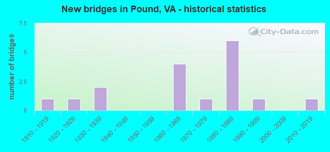
- New bridges - historical statistics
- 11910-1919
- 11920-1929
- 21930-1939
- 41960-1969
- 11970-1979
- 61980-1989
- 11990-1999
- 12010-2019
FCC Registered Antenna Towers:
7- James E McDonald, Pilkenton Pass (Pound 196506777) (Lat: 37.117222 Lon: -82.608972), Type: 61.0, Overall height: 59 m, Registrant: Alltel Communications Of Virginia No. 1, LLC, Aci.Wireless.Regulatory@alltel.Com, , Littl-e Rock, Phone: (501) 905-8555
- Pamelia Y Hoof, Pilkenton Pass (Pound 196506777) (Lat: 37.117222 Lon: -82.608972), Type: 61.0, Overall height: 59 m, Registrant: Alltel Communications Of Virginia No. 1, LLC, Aci.Wireless.Regulatory@alltel.Com, , Littl-e Rock, Phone: (501) 905-8555
- Michael P Goggin, Pilkenton Pass (Pound 196506777) (Lat: 37.117222 Lon: -82.608972), Type: 61.0, Overall height: 59 m, Registrant: New Cingular Wireless Pcs, LLC, Mg7268@att.Com, , Washi-ngton, Phone: (202) 457-2055
- Michael P Goggin, Pilkenton Pass (Pound 196506777) (Lat: 37.117222 Lon: -82.608972), Type: 61.0, Overall height: 59 m, Registrant: At&t Mobility LLC, Mg7268@att.Com, , Washi-ngton, Phone: (202) 457-2055
- Jennifer Burns, Northwest Of State Route 692 (Lat: 37.041444 Lon: -82.611917), Type: 96.0, Structure height: 51195 m, Overall height: 91.4 m, Registrant: Virginia Coalfield Coalition, Larrycarr@bvu.Net, , Leban-on, Phone: (276) 889-1778
- Jennifer Burns, Northwest Of State Route 692 (Lat: 37.041444 Lon: -82.611917), Type: 94.4, Structure height: 51195 m, Overall height: 91.4 m, Registrant: Virginia Coalfield Coalition, Larrycarr@bvu.Net, , Leban-on, Phone: (276) 889-1778
- Jennifer Burns, Northwest Of State Route 692 (Lat: 37.041444 Lon: -82.611917), Type: 94.4, Structure height: 51195 m, Overall height: 91.4 m, Registrant: Virginia Coalfield Coalition, Larrycarr@bvu.Net, , Leban-on, Phone: (276) 889-1778
FCC Registered Private Land Mobile Towers:
1- Atop Pine Mtn (Lat: 37.157056 Lon: -82.524611), Type: Tower, Structure height: 18 m, Call Sign: WPQJ300,
Assigned Frequencies: 462.900 MHz, 462.750 MHz, 462.875 MHz, Grant Date: 07/06/2005, Expiration Date: 08/04/2015, Cancellation Date: 03/31/2014, Certifier: Signature On File, Registrant: Lukas, Nace, Gutierrez & Sachs, LLP, 8300 Greensboro Drive, Mclean, VA 22102, Phone: (703) 584-8665, Fax: (703) 584-8695, Email:
FCC Registered Broadcast Land Mobile Towers:
6- Indian Gap 7.49 Mi S (Lat: 37.015111 Lon: -82.597389), Call Sign: KNAE646, Licensee ID: L00069544,
Assigned Frequencies: 169.500 MHz, Grant Date: 11/04/2000, Expiration Date: 11/02/2005, Cancellation Date: 01/07/2006, Registrant: County Of Wise, Wise, VA 24293, Phone: (804) 674-2492
- Georges Fork Gap 3.43 Mi E (Lat: 37.125111 Lon: -82.542389), Call Sign: WNUJ478,
Assigned Frequencies: 169.500 MHz, Grant Date: 11/02/2005, Expiration Date: 10/15/2015, Cancellation Date: 12/19/2015, Registrant: Dickenson County, 5444 Dickenson Highway, Clintwood, VA 24228, Phone: (276) 926-6330, Fax: (276) 926-4991, Email:
- Pine Mountain (Lat: 37.156944 Lon: -82.524444), Type: Tower, Structure height: 35 m, Overall height: 45 m, Call Sign: WPZR379, Licensee ID: L00760919,
Assigned Frequencies: 157.740 MHz, Grant Date: 01/01/2014, Expiration Date: 02/25/2024, Certifier: Steve Blankenbecler, Registrant: Steve Blankenbecler, Wise, VA 24293, Phone: (276) 679-3221, Fax: (276) 679-3082, Email:
- South Fork BPS, South Fork Bps; Dewey Rd - On Rte 620, Up The Rd A Piece From Dewey Cemetary Rd (Lat: 37.083056 Lon: -82.656944), Type: Pole, Structure height: 9.2 m, Call Sign: WQFD684,
Assigned Frequencies: 154.478 MHz, Grant Date: 06/21/2006, Expiration Date: 06/21/2016, Cancellation Date: 08/27/2016, Certifier: Danny S Buchanan, Registrant: Siemens Water Technologies, 1239 Willow Lake Boulevard, Vadnais Heights, MN 55110, Phone: (651) 766-2700, Fax: (651) 766-2743, Email:
- SOUTH MTN TANK, South Mountain Tank (Lat: 37.157417 Lon: -82.605111), Type: Pole, Structure height: 3.1 m, Call Sign: WQKU776,
Assigned Frequencies: 153.162 MHz, Grant Date: 07/30/2019, Expiration Date: 09/21/2029, Certifier: Danny S Buchanan, Registrant: Fit, 1565 Oak St, Eugene, OR 97401, Phone: (541) 485-8441, Fax: (541) 485-7556, Email:
- SOUTH FORK PUMP ST., Off Of Dewey Rd (Lat: 37.083222 Lon: -82.656528), Type: Pole, Structure height: 4.6 m, Call Sign: WQLY693,
Assigned Frequencies: 153.162 MHz, Grant Date: 05/05/2020, Expiration Date: 05/28/2030, Certifier: Danny S Buchanan, Registrant: Federal License Management, 175 Pine St, Suite 104, Williamsport, PA 17701-6549, Phone: (866) 908-2220, Fax: (570) 323-4002, Email:
FCC Registered Microwave Towers:
4- HASH HOLLOW, Northwest Of State Route 692 (Lat: 37.041444 Lon: -82.611917), Type: Ltower, Structure height: 91.4 m, Overall height: 94.4 m, Call Sign: WRCF358,
Assigned Frequencies: 10775.0 MHz, 10775.0 MHz, 10775.0 MHz, 10855.0 MHz, 10855.0 MHz, 10855.0 MHz, Grant Date: 09/17/2018, Expiration Date: 09/17/2028, Certifier: Gregory M Romano, Registrant: Cellco Partnership, 5055 North Point Pkwy, Np2ne Network Engineering, Alpharetta, GA 30022, Phone: (770) 797-1070, Email:
- BUCKS KNOB, Indian Mountain (Lat: 37.054444 Lon: -82.641611), Type: Mast, Structure height: 57.9 m, Call Sign: WRPA603,
Assigned Frequencies: 5945.20 MHz, Grant Date: 01/10/2022, Expiration Date: 01/10/2032, Certifier: Larry Hall, Registrant: Virginia State Police, 7700 Midlothian Turnpike, North Chesterfield, VA 23261, Phone: (804) 674-4644, Fax: (804) 674-2602, Email:
- Jenkins Tower, Cr-1891 (Lat: 37.163333 Lon: -82.624444), Type: Ltower, Structure height: 33.5 m, Call Sign: WRWL870, Licensee ID: L02129128,
Assigned Frequencies: 10915.0 MHz, 10915.0 MHz, 10915.0 MHz, 10915.0 MHz, Grant Date: 03/07/2023, Expiration Date: 03/07/2033, Certifier: Brandon Hill, Registrant: Hillcom, Inc, 358 Will And Emma Ln, Clintwood, VA 24228, Phone: (276) 393-2441, Email:
- Pound Gap Hwy 23 (Lat: 37.155639 Lon: -82.629028), Overall height: 12.2 m, Call Sign: WFW639,
Assigned Frequencies: 949.500 MHz, Grant Date: 08/09/1984, Expiration Date: 10/01/2027, Registrant: Wdxc Radio, Inc., P.O. Box 877, Pound, VA 24279
FCC Registered Paging Towers:
1- Jenkins Mountain (Lat: 37.166472 Lon: -82.622083), Overall height: 21.3 m, Call Sign: KNKC693,
Assigned Frequencies: 158.700 MHz, 158.100 MHz, 459.325 MHz, Grant Date: 03/26/2019, Expiration Date: 04/01/2029, Registrant: Wilkinson Barker Knauer, LLP, 2300 N Street, Nw, Suite 700, Washington, DC 20037, Phone: (202) 783-4141, Fax: (202) 783-5851, Email:
FCC Registered Amateur Radio Licenses:
16 (See the full list of FCC Registered Amateur Radio Licenses in Pound)FAA Registered Aircraft:
1- Aircraft: CESSNA 172R (Category: Land, Seats: 4, Weight: Up to 12,499 Pounds), Engine: LYCOMING I0-360-B1E (180 HP) (Reciprocating)
N-Number: 2125M, N2125M, N-2125M, Serial Number: 17280905, Year manufactured: 2000, Airworthiness Date: 06/19/2000, Certificate Issue Date: 10/24/2008
Registrant (LLC): Isabella Properties LLC, 12293 Gary Powers Rd, Pound, VA 24279
2003 - 2018 National Fire Incident Reporting System (NFIRS) incidents
- Fire incident types reported to NFIRS in Pound, VA
- 10344.2%Structure Fires
- 6829.2%Outside Fires
- 4218.0%Mobile Property/Vehicle Fires
- 208.6%Other
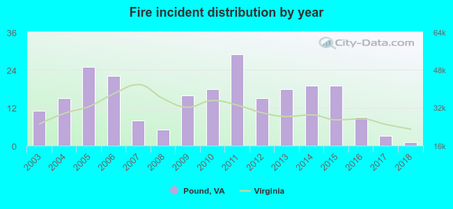 According to the data from the years 2003 - 2018 the average number of fire incidents per year is 15. The highest number of fire incidents - 29 took place in 2011, and the least - 1 in 2018. The data has a dropping trend.
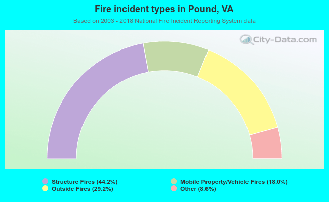 When looking into fire subcategories, the most reports belonged to: Structure Fires (44.2%), and Outside Fires (29.2%).
| Most common first names in Pound, VA among deceased individuals | ||
| Name | Count | Lived (average) |
|---|---|---|
| James | 47 | 71.8 years |
| William | 29 | 76.5 years |
| John | 28 | 70.6 years |
| Mary | 22 | 77.3 years |
| Henry | 13 | 70.6 years |
| Joseph | 12 | 70.9 years |
| Roy | 12 | 72.1 years |
| Ernest | 10 | 71.4 years |
| Sarah | 9 | 77.8 years |
| Frank | 8 | 76.0 years |
| Most common last names in Pound, VA among deceased individuals | ||
| Last name | Count | Lived (average) |
|---|---|---|
| Mullins | 156 | 71.4 years |
| Boggs | 70 | 76.5 years |
| Sturgill | 50 | 75.6 years |
| Meade | 44 | 71.1 years |
| Baker | 41 | 76.1 years |
| Bolling | 37 | 76.1 years |
| Cantrell | 36 | 77.1 years |
| Vanover | 30 | 69.0 years |
| Hubbard | 26 | 76.3 years |
| Stallard | 26 | 76.5 years |
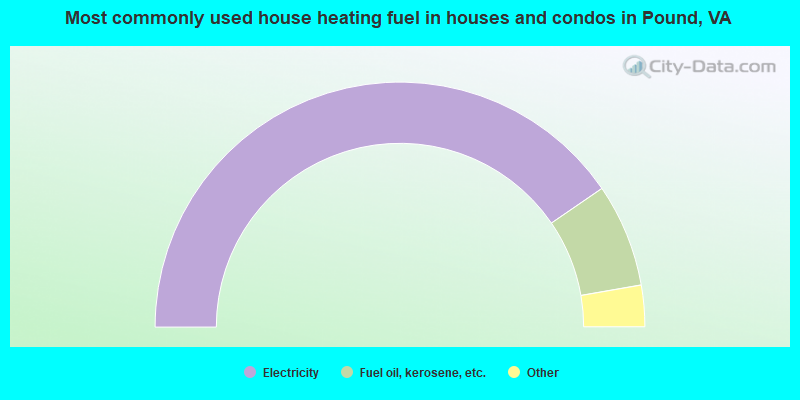
- 81.2%Electricity
- 13.7%Fuel oil, kerosene, etc.
- 3.6%Bottled, tank, or LP gas
- 1.5%Wood
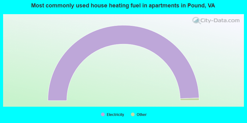
- 100.0%Electricity
Pound compared to Virginia state average:
- Median household income significantly below state average.
- Median house value significantly below state average.
- Black race population percentage significantly below state average.
- Hispanic race population percentage significantly below state average.
- Foreign-born population percentage significantly below state average.
- Length of stay since moving in significantly above state average.
- House age above state average.
- Number of college students below state average.
- Percentage of population with a bachelor's degree or higher below state average.

|
Total of 1 patent application in 2008-2024.