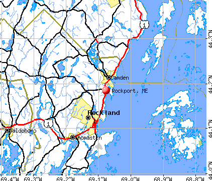
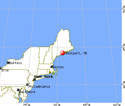
Rockport, Maine
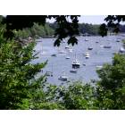
Rockport: Rockport Maine Harbor

Rockport: Rockport Harbor, Maine in the winter when its so cold the saltwater froze in the harbor

Rockport: Rockport Harbor
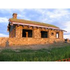
Rockport: Beech Nut
- add
your
Submit your own pictures of this town and show them to the world
- OSM Map
- General Map
- Google Map
- MSN Map
Population change since 2000: +3.8%
 |
| Males: 1,604 | |
| Females: 1,726 |
| Median resident age: | 48.8 years |
| Maine median age: | 43.0 years |
Zip codes: 04856.
| Rockport: | $90,028 |
| ME: | $69,543 |
Estimated per capita income in 2022: $52,112 (it was $25,498 in 2000)
Rockport town income, earnings, and wages data
Estimated median house or condo value in 2022: $472,256 (it was $168,100 in 2000)
| Rockport: | $472,256 |
| ME: | $290,600 |
Detailed information about poverty and poor residents in Rockport, ME


Compare current foreclosures near Rockport, ME:
| Photo | Address | Area | Beds / Baths | Price | Details |
|---|---|---|---|---|---|

|
#1
Knott St
Rockland, ME 04841
|
1,678 sq. feet
|
1 baths 3 beds |
show details | |

|
#2
Philbrick Ave
Rockland, ME 04841
|
- sq. feet
|
- baths - beds |
show details | |

|
#3
River Rd
Tenants Harbor, ME 04860
|
- sq. feet
|
- baths - beds |
show details | |

|
#4
Beechwood St
Thomaston, ME 04861
|
- sq. feet
|
- baths - beds |
show details | |

|
#5
S Union Rd
Union, ME 04862
|
- sq. feet
|
- baths - beds |
show details | |

|
#6
Barrett Hill Rd
Union, ME 04862
|
- sq. feet
|
- baths - beds |
show details | |

|
#7
Pond St
Vinalhaven, ME 04863
|
- sq. feet
|
- baths - beds |
show details | |

|
#8
Jesse Robbins Rd
Belfast, ME 04915
|
- sq. feet
|
- baths - beds |
show details | |

|
#9
Washington Rd
Jefferson, ME 04348
|
- sq. feet
|
- baths - beds |
show details | |

|
Check over 1 million property listings on Foreclosure.com!
|
browse all offers | |||

- 3,21796.6%White alone
- 351.1%Two or more races
- 381.1%Hispanic
- 170.5%American Indian alone
- 140.4%Asian alone
- 90.3%Black alone
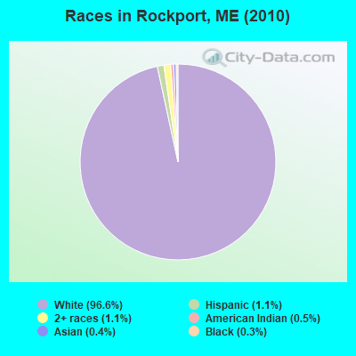
Races in Rockport detailed stats: ancestries, foreign born residents, place of birth
According to our research of Maine and other state lists, there were 5 registered sex offenders living in Rockport, Maine as of April 28, 2024.
The ratio of all residents to sex offenders in Rockport is 666 to 1.
The ratio of registered sex offenders to all residents in this city is lower than the state average.
Type |
2009 |
2010 |
2011 |
2012 |
2013 |
2014 |
2015 |
2016 |
2017 |
2018 |
2019 |
2020 |
2021 |
2022 |
|---|---|---|---|---|---|---|---|---|---|---|---|---|---|---|
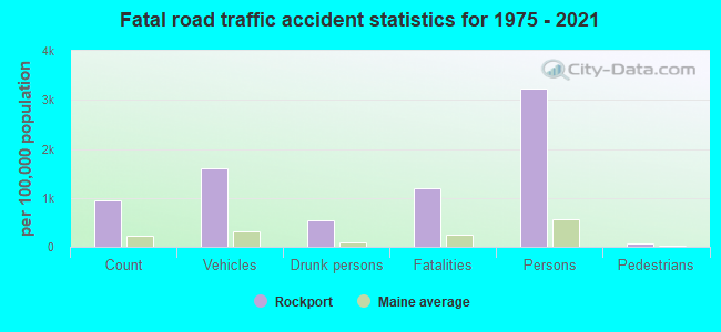
| Murders (per 100,000) | 0 (0.0) | 0 (0.0) | 0 (0.0) | 0 (0.0) | 0 (0.0) | 0 (0.0) | 0 (0.0) | 0 (0.0) | 0 (0.0) | 0 (0.0) | 0 (0.0) | 0 (0.0) | 0 (0.0) | 0 (0.0) |
| Rapes (per 100,000) | 0 (0.0) | 0 (0.0) | 0 (0.0) | 0 (0.0) | 0 (0.0) | 0 (0.0) | 0 (0.0) | 0 (0.0) | 0 (0.0) | 0 (0.0) | 0 (0.0) | 0 (0.0) | 0 (0.0) | 0 (0.0) |
| Robberies (per 100,000) | 0 (0.0) | 0 (0.0) | 1 (30.0) | 0 (0.0) | 0 (0.0) | 1 (30.1) | 0 (0.0) | 0 (0.0) | 0 (0.0) | 0 (0.0) | 0 (0.0) | 0 (0.0) | 0 (0.0) | 0 (0.0) |
| Assaults (per 100,000) | 0 (0.0) | 0 (0.0) | 0 (0.0) | 1 (30.0) | 0 (0.0) | 0 (0.0) | 1 (29.7) | 0 (0.0) | 1 (29.5) | 0 (0.0) | 1 (29.6) | 0 (0.0) | 0 (0.0) | 0 (0.0) |
| Burglaries (per 100,000) | 8 (225.2) | 9 (270.3) | 6 (180.2) | 7 (210.1) | 4 (120.7) | 0 (0.0) | 4 (118.8) | 4 (117.9) | 3 (88.5) | 0 (0.0) | 2 (59.2) | 0 (0.0) | 3 (88.4) | 1 (26.9) |
| Thefts (per 100,000) | 25 (703.6) | 25 (750.8) | 31 (930.9) | 25 (750.5) | 17 (513.0) | 28 (843.4) | 12 (356.3) | 23 (678.1) | 10 (295.1) | 15 (443.3) | 15 (444.0) | 12 (356.4) | 14 (412.4) | 20 (537.8) |
| Auto thefts (per 100,000) | 1 (28.1) | 0 (0.0) | 1 (30.0) | 1 (30.0) | 1 (30.2) | 1 (30.1) | 0 (0.0) | 0 (0.0) | 0 (0.0) | 0 (0.0) | 1 (29.6) | 0 (0.0) | 1 (29.5) | 1 (26.9) |
| Arson (per 100,000) | 0 (0.0) | 0 (0.0) | 0 (0.0) | 0 (0.0) | 0 (0.0) | 0 (0.0) | 0 (0.0) | 0 (0.0) | 0 (0.0) | 0 (0.0) | 0 (0.0) | 0 (0.0) | 0 (0.0) | 0 (0.0) |
| City-Data.com crime index | 46.2 | 48.9 | 61.3 | 53.1 | 31.4 | 45.2 | 28.5 | 35.4 | 23.9 | 17.7 | 30.2 | 14.3 | 25.0 | 25.5 |
The City-Data.com crime index weighs serious crimes and violent crimes more heavily. Higher means more crime, U.S. average is 246.1. It adjusts for the number of visitors and daily workers commuting into cities.
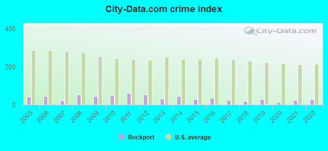
Crime rate in Rockport detailed stats: murders, rapes, robberies, assaults, burglaries, thefts, arson
Full-time law enforcement employees in 2021, including police officers: 5 (5 officers - 4 male; 1 female).
| Officers per 1,000 residents here: | 1.47 |
| Maine average: | 1.71 |
 Recent articles from our blog. Our writers, many of them Ph.D. graduates or candidates, create easy-to-read articles on a wide variety of topics.

 | Year round living in Maine. (137 replies) |
| Looking at Maine (41 replies) |
| Planning my move to Maine (52 replies) |
| Blue Hill Peninsula or Damariscotta (19 replies) |
| Small town Maine retirement (47 replies) |
| Photos of Maine (4586 replies) |
Latest news from Rockport, ME collected exclusively by city-data.com from local newspapers, TV, and radio stations
Rockport, ME City Guides:
Ancestries: English (31.0%), Irish (12.0%), United States (11.5%), German (10.2%), Scottish (7.1%), French (5.7%).
Current Local Time: EST time zone
Elevation: 66 feet
Land area: 21.7 square miles.
Population density: 153 people per square mile (very low).
89 residents are foreign born (1.3% North America, 1.2% Europe, 0.3% Asia).
| This town: | 2.8% |
| Maine: | 2.9% |
| Rockport town: | 1.2% ($2,053) |
| Maine: | 1.5% ($1,417) |
Nearest city with pop. 50,000+: Portland, ME  (68.4 miles , pop. 64,249).
Nearest city with pop. 200,000+: Boston, MA (163.1 miles , pop. 589,141).
Nearest city with pop. 1,000,000+: Bronx, NY (335.2 miles , pop. 1,332,650).
Nearest cities:
), ), Latitude: 44.18 N, Longitude: 69.10 W
Area code commonly used in this area: 207

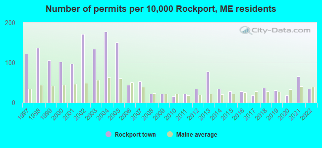
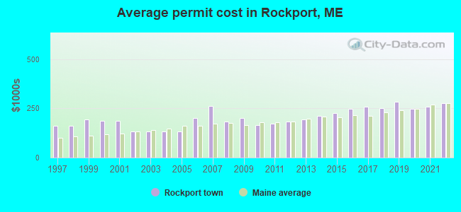
Single-family new house construction building permits:
- 2022: 11 buildings, average cost: $277,400
- 2021: 21 buildings, average cost: $259,200
- 2020: 6 buildings, average cost: $248,200
- 2019: 10 buildings, average cost: $282,200
- 2018: 12 buildings, average cost: $249,800
- 2017: 6 buildings, average cost: $256,500
- 2016: 9 buildings, average cost: $246,000
- 2015: 9 buildings, average cost: $226,800
- 2014: 11 buildings, average cost: $211,200
- 2013: 25 buildings, average cost: $193,300
- 2012: 11 buildings, average cost: $184,000
- 2011: 7 buildings, average cost: $172,800
- 2010: 5 buildings, average cost: $165,900
- 2009: 7 buildings, average cost: $200,000
- 2008: 7 buildings, average cost: $182,400
- 2007: 17 buildings, average cost: $260,700
- 2006: 14 buildings, average cost: $200,000
- 2005: 48 buildings, average cost: $132,400
- 2004: 57 buildings, average cost: $132,400
- 2003: 43 buildings, average cost: $132,800
- 2002: 55 buildings, average cost: $130,700
- 2001: 31 buildings, average cost: $187,300
- 2000: 33 buildings, average cost: $186,400
- 1999: 34 buildings, average cost: $193,200
- 1998: 44 buildings, average cost: $160,600
- 1997: 39 buildings, average cost: $160,800
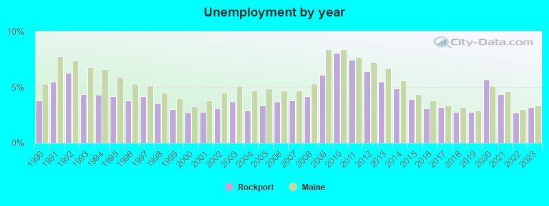
| Here: | 3.2% |
| Maine: | 3.4% |
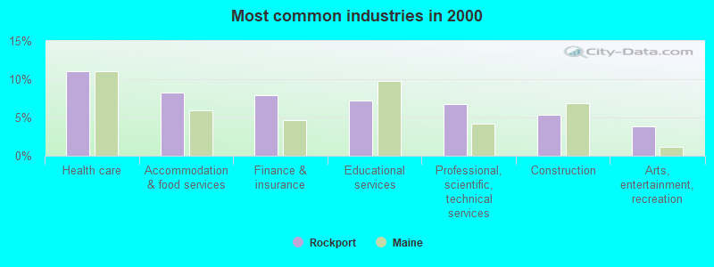
- Health care (11.0%)
- Accommodation & food services (8.2%)
- Finance & insurance (7.9%)
- Educational services (7.2%)
- Professional, scientific, technical services (6.8%)
- Construction (5.4%)
- Arts, entertainment, recreation (3.8%)
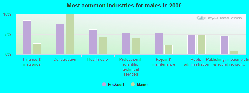
- Finance & insurance (8.5%)
- Construction (7.6%)
- Health care (6.2%)
- Professional, scientific, technical services (5.5%)
- Repair & maintenance (5.2%)
- Public administration (4.9%)
- Publishing, motion picture & sound recording industries (4.7%)
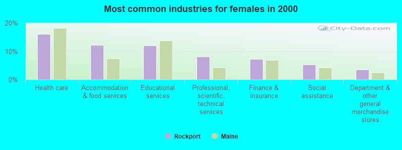
- Health care (16.2%)
- Accommodation & food services (12.2%)
- Educational services (12.1%)
- Professional, scientific, technical services (8.2%)
- Finance & insurance (7.3%)
- Social assistance (5.3%)
- Department & other general merchandise stores (3.5%)
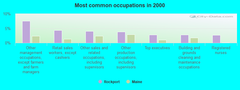
- Other management occupations, except farmers and farm managers (7.5%)
- Retail sales workers, except cashiers (4.3%)
- Other sales and related occupations, including supervisors (4.1%)
- Other production occupations, including supervisors (3.8%)
- Top executives (2.8%)
- Building and grounds cleaning and maintenance occupations (2.7%)
- Registered nurses (2.7%)
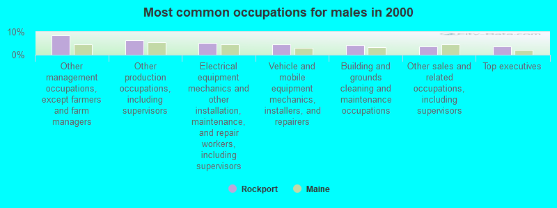
- Other management occupations, except farmers and farm managers (8.4%)
- Other production occupations, including supervisors (6.3%)
- Electrical equipment mechanics and other installation, maintenance, and repair workers, including supervisors (5.1%)
- Vehicle and mobile equipment mechanics, installers, and repairers (4.4%)
- Building and grounds cleaning and maintenance occupations (4.2%)
- Other sales and related occupations, including supervisors (3.7%)
- Top executives (3.6%)

- Other management occupations, except farmers and farm managers (6.6%)
- Registered nurses (5.5%)
- Waiters and waitresses (5.4%)
- Retail sales workers, except cashiers (5.0%)
- Other sales and related occupations, including supervisors (4.4%)
- Bookkeeping, accounting, and auditing clerks (3.8%)
- Counselors, social workers, and other community and social service specialists (3.3%)
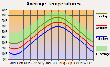
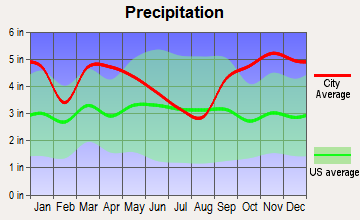
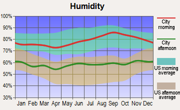
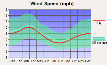
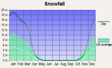
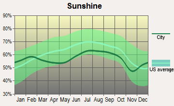
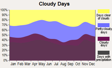
Average climate in Rockport, Maine
Based on data reported by over 4,000 weather stations
Earthquake activity:
Rockport-area historical earthquake activity is significantly above Maine state average. It is 78% smaller than the overall U.S. average.On 10/16/2012 at 23:12:25, a magnitude 4.7 (4.7 ML, Depth: 10.0 mi, Class: Light, Intensity: IV - V) earthquake occurred 87.5 miles away from the city center
On 4/20/2002 at 10:50:47, a magnitude 5.3 (5.3 ML, Depth: 3.0 mi, Class: Moderate, Intensity: VI - VII) earthquake occurred 228.6 miles away from Rockport center
On 4/20/2002 at 10:50:47, a magnitude 5.2 (5.2 MB, 4.2 MS, 5.2 MW, 5.0 MW) earthquake occurred 229.5 miles away from the city center
On 1/19/1982 at 00:14:42, a magnitude 4.7 (4.5 MB, 4.7 MD, 4.5 LG) earthquake occurred 133.4 miles away from the city center
On 10/7/1983 at 10:18:46, a magnitude 5.3 (5.1 MB, 5.3 LG, 5.1 ML) earthquake occurred 261.0 miles away from Rockport center
On 2/26/1999 at 03:38:43, a magnitude 3.8 (3.8 LG, Depth: 2.0 mi, Class: Light, Intensity: II - III) earthquake occurred 29.4 miles away from the city center
Magnitude types: regional Lg-wave magnitude (LG), body-wave magnitude (MB), duration magnitude (MD), local magnitude (ML), surface-wave magnitude (MS), moment magnitude (MW)
Natural disasters:
The number of natural disasters in Knox County (23) is greater than the US average (15).Major Disasters (Presidential) Declared: 18
Emergencies Declared: 4
Causes of natural disasters: Floods: 16, Storms: 12, Winter Storms: 4, Snows: 3, Hurricanes: 2, Blizzard: 1, Heavy Rain: 1, Ice Storm: 1, Landslide: 1, Mudslide: 1, Snowfall: 1, Wind: 1, Other: 1 (Note: some incidents may be assigned to more than one category).
Hospitals and medical centers in Rockport:
Other hospitals and medical centers near Rockport:
- CAMDEN COMM HOSP HC CENTR (Nursing Home, about 2 miles away; CAMDEN, ME)
- WINDWARD GARDENS (Nursing Home, about 3 miles away; CAMDEN, ME)
- SHORE VILLAGE REHAB AND NURSING (Nursing Home, about 4 miles away; ROCKLAND, ME)
- KNOX CENTER FOR LONG TERM CARE (Nursing Home, about 6 miles away; ROCKLAND, ME)
- KNOX CENTER FOR LTC (Nursing Home, about 6 miles away; ROCKLAND, ME)
- KNO-WAL-LIN HOMECARE AND HOSPICE (Home Health Center, about 6 miles away; ROCKLAND, ME)
- FIELDCREST MANOR (Nursing Home, about 16 miles away; WALDOBORO, ME)
Heliports located in Rockport:
Colleges/universities with over 2000 students nearest to Rockport:
- University of Maine at Augusta (about 37 miles; Augusta, ME; Full-time enrollment: 3,204)
- Husson University (about 48 miles; Bangor, ME; FT enrollment: 2,421)
- University of Maine (about 54 miles; Orono, ME; FT enrollment: 8,931)
- University of Maine at Farmington (about 62 miles; Farmington, ME; FT enrollment: 2,036)
- Southern Maine Community College (about 68 miles; South Portland, ME; FT enrollment: 4,666)
- University of Southern Maine (about 69 miles; Portland, ME; FT enrollment: 6,647)
- Saint Joseph's College of Maine (about 74 miles; Standish, ME; FT enrollment: 2,010)
Public high school in Rockport:
- CAMDEN HILLS REGIONAL H S (Students: 716, Location: 25 KEELSON DRIVE, Grades: 9-12)
Public elementary/middle school in Rockport:
Private elementary/middle school in Rockport:
Points of interest:
Notable locations in Rockport: Oakland Park (A), Samoset Golf Course (B), Rockport Town Landing (C), Rockport Marine (D), Rockport Historic Kiln Area (E), Rockport Boat Club (F), Meguniticook by the Sea Campground (G), North East Mobile Health Services (H), Maine Coast Artists Gallery (I), Rockport Fire Department Main Station (J), Rockport Opera House (K), Rockport Public Library (L), Town Office Number 1 (M), Town Office Number 2 (N), Rockport Fire Department West Rockport Station (O). Display/hide their locations on the map
Churches in Rockport include: West Rockport Baptist Church (A), Vesper Hill Childrens Chapel (B). Display/hide their locations on the map
Cemeteries: Samoset Cemetery (1), Seaview Cemetery (2), Amesbury Cemetery (3), New Rockville Cemetery (4). Display/hide their locations on the map
Lakes and reservoirs: Grassy Pond (A), Lilly Pond (B), Maces Pond (C), Rocky Pond (D), Chickawaukie Pond (E), Mirror Lake (F), Tolman Pond (G). Display/hide their locations on the map
River: Goose River (A). Display/hide its location on the map
Parks in Rockport include: Walker Park (1), Rockport Recreation Park (2), Rockport Marine Park (3), Rockport Historic District (4), Cramer Park (5). Display/hide their locations on the map
Hotels: Spruce Ridge Inn (689 Commercial Street) (1), White Gates Inn (700 Commercial Street) (2), Oakland Seashore Cabins & Motel (Camden Road) (3), Island View Inn (904 Commercial Street) (4), Strawberry Hill Motor Inn (886 Commercial Street) (5). Display/hide their approximate locations on the map
Drinking water stations with addresses in Rockport and their reported violations in the past:
OFFSHORE RESTAURANT (Population served: 510, Groundwater):Past monitoring violations:ASHWOOD WALDORF SCHOOL (Population served: 145, Groundwater):
- 3 routine major monitoring violations
Past health violations:OAKLAND PARK BOWLING LANES (Population served: 100, Groundwater):Past monitoring violations:
- MCL, Monthly (TCR) - In FEB-2013, Contaminant: Coliform. Follow-up actions: St Public Notif requested (FEB-19-2013), St Formal NOV issued (FEB-19-2013), St Compliance achieved (MAR-01-2013), St Public Notif received (MAY-10-2013)
- MCL, Monthly (TCR) - In JAN-2013, Contaminant: Coliform. Follow-up actions: St Public Notif requested (JAN-07-2013), St Formal NOV issued (JAN-07-2013), St Public Notif received (FEB-08-2013), St Compliance achieved (MAR-01-2013)
- MCL, Monthly (TCR) - In NOV-2012, Contaminant: Coliform. Follow-up actions: St Public Notif requested (DEC-04-2012), St Formal NOV issued (DEC-04-2012), St Public Notif received (DEC-14-2012), St Compliance achieved (MAR-01-2013)
- MCL, Monthly (TCR) - In OCT-2012, Contaminant: Coliform. Follow-up actions: St Public Notif requested (OCT-29-2012), St Formal NOV issued (OCT-29-2012), St Public Notif received (NOV-21-2012), St Compliance achieved (MAR-01-2013)
- 2 routine major monitoring violations
- One regular monitoring violation
Past monitoring violations:GOOSE RIVER GOLF COURSE (Population served: 25, Groundwater):
- One routine major monitoring violation
Past health violations:CENTER FOR FURNITURE CRAFTSMENSHIP (Population served: 25, Groundwater):Past monitoring violations:
- MCL, Monthly (TCR) - In JUL-2011, Contaminant: Coliform. Follow-up actions: St Public Notif requested (JUL-29-2011), St Formal NOV issued (JUL-29-2011), St Compliance achieved (AUG-30-2011)
- MCL, Monthly (TCR) - In JUN-2011, Contaminant: Coliform. Follow-up actions: St Public Notif requested (JUL-11-2011), St Formal NOV issued (JUL-11-2011), St Compliance achieved (AUG-30-2011)
- MCL, Monthly (TCR) - In JUL-2009, Contaminant: Coliform. Follow-up actions: St Public Notif requested (JUL-24-2009), St Formal NOV issued (JUL-24-2009), St Compliance achieved (SEP-07-2011), St Intentional no-action (SEP-09-2011)
- 5 routine major monitoring violations
- 3 minor monitoring violations
- 2 regular monitoring violations
Past health violations:
- MCL, Monthly (TCR) - In NOV-2012, Contaminant: Coliform. Follow-up actions: St Public Notif requested (NOV-13-2012), St Formal NOV issued (NOV-13-2012), St Compliance achieved (JAN-14-2013), St Public Notif received (JAN-16-2013)
Drinking water stations with addresses in Rockport that have no violations reported:
- LEDGEWOOD PROFESSIONAL BUILDING (Population served: 32, Primary Water Source Type: Groundwater)
| This town: | 2.3 people |
| Maine: | 2.3 people |
| This town: | 68.0% |
| Whole state: | 62.9% |
| This town: | 7.8% |
| Whole state: | 9.4% |
Likely homosexual households (counted as self-reported same-sex unmarried-partner households)
- Lesbian couples: 0.8% of all households
- Gay men: 0.7% of all households
| This town: | 7.1% |
| Whole state: | 10.9% |
| This town: | 2.3% |
| Whole state: | 4.1% |
2 people in hospitals with patients who have no usual home elsewhere in 2010
4 people in homes for the mentally retarded in 2000
Banks with branches in Rockport (2011 data):
- The First, N.A.: Rockport Branch at 114 Commercial Street, branch established on 1997/10/06. Info updated 2010/06/01: Bank assets: $1,338.8 mil, Deposits: $942.2 mil, headquarters in Damariscotta, ME, positive income, Commercial Lending Specialization, 14 total offices, Holding Company: First Bancorp, Inc., The
- Bangor Savings Bank: Camden/Rockport at 5 Commercial Street, branch established on 2000/07/03. Info updated 2008/12/02: Bank assets: $2,556.3 mil, Deposits: $1,940.3 mil, headquarters in Bangor, ME, positive income, Commercial Lending Specialization, 58 total offices, Holding Company: Bangor Bancorp, Mhc
For population 15 years and over in Rockport:
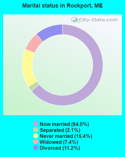
- Never married: 15.4%
- Now married: 64.0%
- Separated: 2.1%
- Widowed: 7.4%
- Divorced: 11.2%
For population 25 years and over in Rockport:
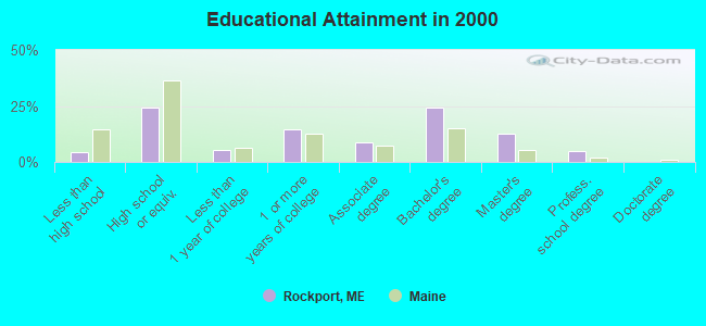
- High school or higher: 95.4%
- Bachelor's degree or higher: 42.5%
- Graduate or professional degree: 18.0%
- Unemployed: 2.8%
- Mean travel time to work (commute): 16.4 minutes
| Here: | 10.1 |
| Maine average: | 11.2 |
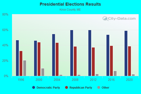
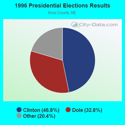
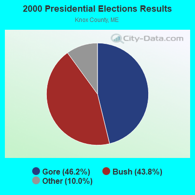
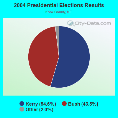

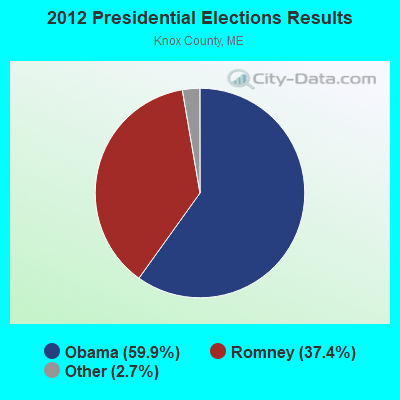

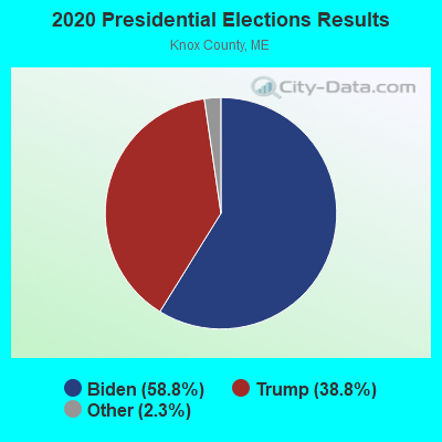
Graphs represent county-level data. Detailed 2008 Election Results
Religion statistics for Rockport, ME (based on Knox County data)
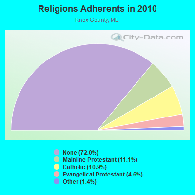
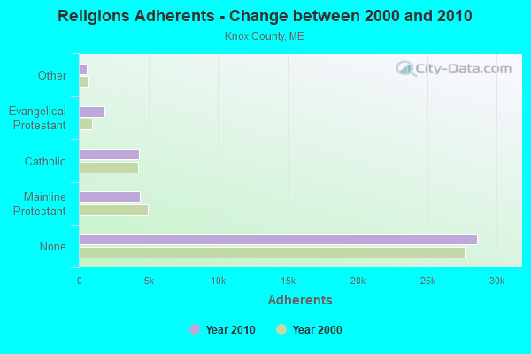
| Religion | Adherents | Congregations |
|---|---|---|
| Mainline Protestant | 4,400 | 29 |
| Catholic | 4,340 | 4 |
| Evangelical Protestant | 1,813 | 23 |
| Other | 569 | 6 |
| None | 28,614 | - |
Food Environment Statistics:
| This county: | 4.17 / 10,000 pop. |
| Maine: | 2.80 / 10,000 pop. |
| Here: | 2.21 / 10,000 pop. |
| Maine: | 2.20 / 10,000 pop. |
| This county: | 7.37 / 10,000 pop. |
| Maine: | 5.75 / 10,000 pop. |
| Knox County: | 19.40 / 10,000 pop. |
| State: | 11.02 / 10,000 pop. |
| Here: | 7.8% |
| Maine: | 8.2% |
| Knox County: | 21.6% |
| State: | 25.0% |
| Businesses in Rockport, ME | ||||
| Name | Count | Name | Count | |
|---|---|---|---|---|
| Dunkin Donuts | 1 | Taco Bell | 1 | |
| FedEx | 1 | U-Haul | 1 | |
| KFC | 1 | UPS | 1 | |
| MasterBrand Cabinets | 2 | Vans | 1 | |
| New Balance | 1 | YMCA | 1 | |
| Nike | 1 | |||
Strongest AM radio stations in Rockport:
- WRKD (1450 AM; 1 kW; ROCKLAND, ME; Owner: CLEAR CHANNEL BROADCASTING LICENSES, INC.)
- WSKW (1160 AM; 10 kW; SKOWHEGAN, ME; Owner: MOUNTAIN WIRELESS, INCORPORATED)
- WZON (620 AM; 5 kW; BANGOR, ME; Owner: THE ZONE CORPORATION)
- WFAU (1280 AM; 5 kW; GARDINER, ME; Owner: CAPSTAR TX LIMITED PARTNERSHIP)
- WRKO (680 AM; 50 kW; BOSTON, MA; Owner: ENTERCOM BOSTON LICENSE, LLC)
- WDEA (1370 AM; 5 kW; ELLSWORTH, ME; Owner: CUMULUS LICENSING CORP.)
- WABI (910 AM; 5 kW; BANGOR, ME; Owner: CLEAR CHANNEL BROADCASTING LICENSES, INC.)
- WTME (780 AM; 10 kW; RUMFORD, ME; Owner: MOUNTAIN VALLEY BROADCASTING, INC.)
- WEEI (850 AM; 50 kW; BOSTON, MA; Owner: ENTERCOM BOSTON LICENSE, LLC)
- WBZ (1030 AM; 50 kW; BOSTON, MA; Owner: INFINITY BROADCASTING OPERATIONS, INC.)
- WMTW (870 AM; 10 kW; GORHAM, ME; Owner: RADIO PARTNERS OF MAINE, L.P.)
- WGAN (560 AM; 5 kW; PORTLAND, ME; Owner: SAGA COMMUNICATIONS OF NEW ENGLAND, LLC)
- WCRN (830 AM; 50 kW; WORCESTER, MA; Owner: CARTER BROADCASTING CORPORATION)
Strongest FM radio stations in Rockport:
- WMEP (90.5 FM; CAMDEN, ME; Owner: MAINE PUBLIC BROADCASTING CORP.)
- WQSS (102.5 FM; CAMDEN, ME; Owner: CLEAR CHANNEL BROADCASTING LICENSES, INC.)
- WMCM (103.3 FM; ROCKLAND, ME; Owner: CLEAR CHANNEL BROADCASTING LICENSES, INC.)
- WBQX (106.9 FM; THOMASTON, ME; Owner: MARINER BROADCASTING LIMITED PARTNER)
- WFZX (101.7 FM; SEARSPORT, ME; Owner: CLEAR CHANNEL BROADCASTING LICENSES, INC.)
- WBYA (105.5 FM; ISLESBORO, ME; Owner: MARINER BROADCASTING LIMTED PARTNERSHIP)
- WBFB (104.7 FM; BELFAST, ME; Owner: CLEAR CHANNEL BROADCASTING LICENSES, INC.)
- WWBX (97.1 FM; BANGOR, ME; Owner: CLEAR CHANNEL BROADCASTING LICENSES, INC.)
- WERU-FM (89.9 FM; BLUE HILL, ME; Owner: SALT POND COMMUNITY B/C COMPANY)
- WWMJ (95.7 FM; ELLSWORTH, ME; Owner: CUMULUS LICENSING CORP.)
- WKIT-FM (100.3 FM; BREWER, ME; Owner: THE ZONE CORPORATION)
- WWWA (95.3 FM; WINSLOW, ME; Owner: LIGHT OF LIFE MINISTRIES, INC.)
- WCME (96.7 FM; BOOTHBAY HARBOR, ME; Owner: CAPSTAR TX LIMITED PARTNERSHIP)
- WMME-FM (92.3 FM; AUGUSTA, ME; Owner: CITADEL BROADCASTING COMPANY)
- WRFR-LP (93.3 FM; ROCKLAND, ME; Owner: PENOBSCOT SCHOOL)
TV broadcast stations around Rockport:
- W64BY (Channel 64; ROCKLAND, ME; Owner: CRAIG MINISTRIES, INC.)
- National Bridge Inventory (NBI) Statistics
- 1Number of bridges
- 3ft / 0.8mTotal length
- 573Total average daily traffic
- 28Total average daily truck traffic
- 917Total future (year 2036) average daily traffic
FCC Registered Antenna Towers:
3- Audra Klumb, 0 Vinal Street (Lat: 44.173472 Lon: -69.129028), Type: 45.7, Structure height: 23013 m, Overall height: 45.7 m, Registrant: A&d Klumb Environmental, LLC, Klumbenvironmental@klumbenv.Com, , Webst-er, Phone: (603) 746-5065
- Audra Klumb, 0 Vinal Street, Type: 45.7, Structure height: 23013 m, Overall height: 45.7 m, Registrant: A&d Klumb Environmental, LLC, Klumbenvironmental@klumbenv.Com, , Webst-er, Phone: (603) 746-5065
- Audra Klumb, 0 Vinal Street (Lat: 44.173472 Lon: -69.129028), Type: 45.7, Structure height: 23013 m, Overall height: 45.7 m, Registrant: A&d Klumb Environmental, LLC, Klumbenvironmental@klumbenv.Com, , Webst-er, Phone: (603) 746-5065
FCC Registered Private Land Mobile Towers:
1 (See the full list of FCC Registered Private Land Mobile Towers in Rockport, ME)FCC Registered Broadcast Land Mobile Towers:
9 (See the full list of FCC Registered Broadcast Land Mobile Towers)FCC Registered Microwave Towers:
3 (See the full list of FCC Registered Microwave Towers in this town)FCC Registered Paging Towers:
3 (See the full list of FCC Registered Paging Towers)FCC Registered Maritime Coast & Aviation Ground Towers:
2 (See the full list of FCC Registered Maritime Coast & Aviation Ground Towers)FCC Registered Amateur Radio Licenses:
35 (See the full list of FCC Registered Amateur Radio Licenses in Rockport)FAA Registered Aircraft:
4- Aircraft: CESSNA 182H (Category: Land, Seats: 4, Weight: Up to 12,499 Pounds, Speed: 119 mph), Engine: CONT MOTOR O-470 SERIES (230 HP) (Reciprocating)
N-Number: 1880X, N1880X, N-1880X, Serial Number: 18255980, Year manufactured: 1964, Airworthiness Date: 12/31/1964, Certificate Issue Date: 11/10/2008
Registrant (Individual): John W Karod, 449 South St, Rockport, ME 04856 - Aircraft: WEBB PETER C VANS RV-9A (Category: Land, Seats: 2, Weight: Up to 12,499 Pounds), Engine: LYCOMING O-320-D2A (160 HP) (Reciprocating)
N-Number: 337CW, N337CW, N-337CW, Serial Number: 90811, Year manufactured: 2010, Airworthiness Date: 05/07/2010, Certificate Issue Date: 01/26/2010
Registrant (Individual): Peter C Webb, 7 Rockport Woods, Rockport, ME 04856 - Aircraft: PIPER J3C-65 (Category: Land, Seats: 2, Weight: Up to 12,499 Pounds, Speed: 67 mph), Engine: CONT MOTOR A&C65 SERIES (65 HP) (Reciprocating)
N-Number: 88597, N88597, N-88597, Serial Number: 16223, Year manufactured: 1946, Airworthiness Date: 09/04/1959, Certificate Issue Date: 06/07/2016
Registrant (Individual): John W S Eastman, Po Box 124, Rockport, ME 04856 - Aircraft: CESSNA 175A (Category: Land, Seats: 4, Weight: Up to 12,499 Pounds, Speed: 105 mph), Engine: CONT MOTOR GO-300 SERIES (175 HP) (Reciprocating)
N-Number: 6989E, N6989E, N-6989E, Serial Number: 56489, Year manufactured: 1960, Airworthiness Date: 06/29/1960, Certificate Issue Date: 08/15/2001
Registrant (Individual): Joseph M Bennis, 16 Grove St, Rockport, ME 04856
Deregistered: Cancel Date: 06/21/2017
2002 - 2018 National Fire Incident Reporting System (NFIRS) incidents
- Fire incident types reported to NFIRS in Rockport, ME
- 9651.1%Structure Fires
- 5127.1%Outside Fires
- 3719.7%Mobile Property/Vehicle Fires
- 42.1%Other
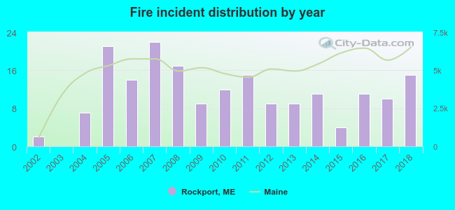 According to the data from the years 2002 - 2018 the average number of fires per year is 11. The highest number of fires - 22 took place in 2007, and the least - 0 in 2003. The data has a growing trend.
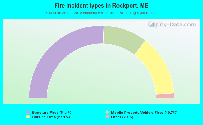 When looking into fire subcategories, the most incidents belonged to: Structure Fires (51.1%), and Outside Fires (27.1%).
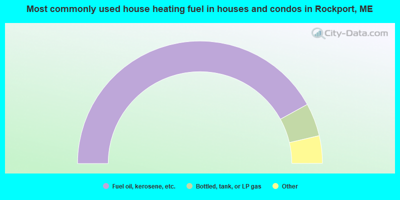
- 84.0%Fuel oil, kerosene, etc.
- 8.7%Bottled, tank, or LP gas
- 3.4%Wood
- 2.8%Electricity
- 0.5%Utility gas
- 0.5%Coal or coke
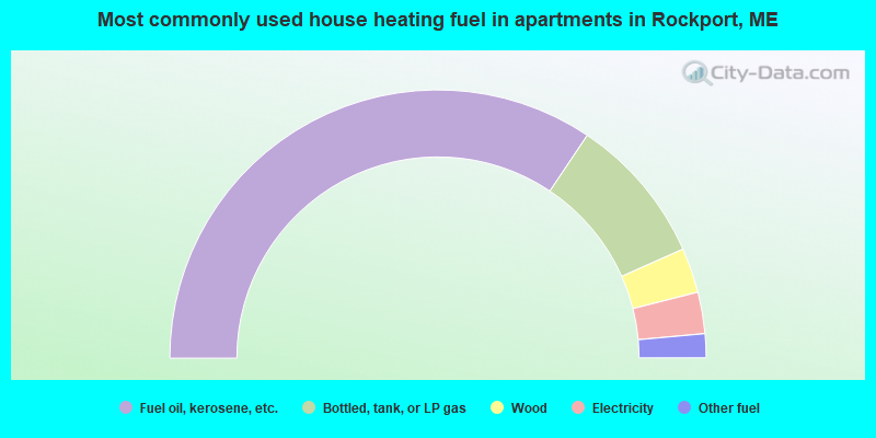
- 68.8%Fuel oil, kerosene, etc.
- 17.9%Bottled, tank, or LP gas
- 5.4%Wood
- 5.0%Electricity
- 2.9%Other fuel
Rockport compared to Maine state average:
- Median house value above state average.
- Unemployed percentage significantly below state average.
- Black race population percentage significantly below state average.
- Hispanic race population percentage below state average.
- Median age above state average.
- Length of stay since moving in significantly above state average.
- Number of rooms per house significantly below state average.
- House age significantly below state average.
- Percentage of population with a bachelor's degree or higher above state average.

|
|
Total of 43 patent applications in 2008-2024.