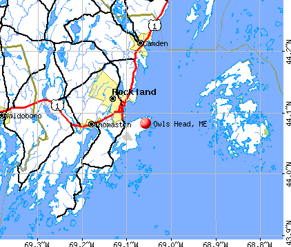
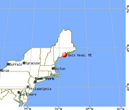
Owls Head, Maine
Submit your own pictures of this town and show them to the world
- OSM Map
- General Map
- Google Map
- MSN Map
Population change since 2000: -1.3%
 |
| Males: 762 | |
| Females: 818 |
| Median resident age: | 52.1 years |
| Maine median age: | 43.0 years |
Zip codes: 04854.
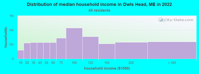
| Owls Head: | $76,572 |
| ME: | $69,543 |
Estimated per capita income in 2022: $46,312 (it was $22,660 in 2000)
Owls Head town income, earnings, and wages data
Estimated median house or condo value in 2022: $372,524 (it was $132,600 in 2000)
| Owls Head: | $372,524 |
| ME: | $290,600 |
Detailed information about poverty and poor residents in Owls Head, ME


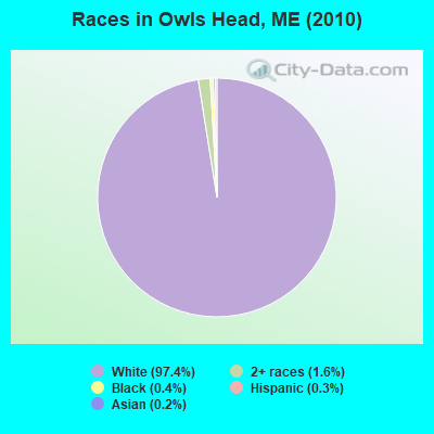
- 1,53997.4%White alone
- 251.6%Two or more races
- 70.4%Black alone
- 40.3%Hispanic
- 30.2%Asian alone
- 10.06%American Indian alone
- 10.06%Other race alone
Races in Owls Head detailed stats: ancestries, foreign born residents, place of birth
 Recent articles from our blog. Our writers, many of them Ph.D. graduates or candidates, create easy-to-read articles on a wide variety of topics.

 | Owls Head (21 replies) |
| Maine Covid 19 Thread (376 replies) |
| Year round living in Maine. (137 replies) |
| Looking at Maine (41 replies) |
| Planning my move to Maine (52 replies) |
| Small town Maine retirement (47 replies) |
Latest news from Owls Head, ME collected exclusively by city-data.com from local newspapers, TV, and radio stations
Owls Head, ME City Guides:
Ancestries: English (28.9%), Irish (12.7%), United States (12.1%), German (10.9%), French (7.4%), Scottish (5.1%).
Current Local Time: EST time zone
Incorporated on 07/09/1921
Elevation: 65 feet
Land area: 8.89 square miles.
Population density: 178 people per square mile (very low).
44 residents are foreign born (1.7% Europe, 0.7% North America).
| This town: | 2.7% |
| Maine: | 2.9% |
| Owls Head town: | 1.0% ($1,339) |
| Maine: | 1.5% ($1,417) |
Nearest city with pop. 50,000+: Portland, ME  (65.7 miles , pop. 64,249).
Nearest city with pop. 200,000+: Boston, MA (157.7 miles , pop. 589,141).
Nearest city with pop. 1,000,000+: Bronx, NY (330.8 miles , pop. 1,332,650).
Nearest cities:
), ), )Latitude: 44.07 N, Longitude: 69.08 W
Area code commonly used in this area: 207

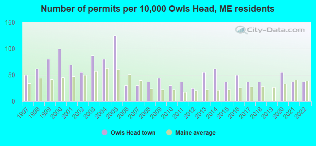
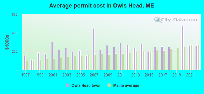
Single-family new house construction building permits:
- 2022: 6 buildings, average cost: $259,200
- 2021: 6 buildings, average cost: $259,200
- 2020: 9 buildings, average cost: $473,700
- 2018: 6 buildings, average cost: $249,800
- 2017: 6 buildings, average cost: $254,700
- 2016: 8 buildings, average cost: $246,000
- 2015: 6 buildings, average cost: $195,700
- 2014: 10 buildings, average cost: $282,400
- 2013: 9 buildings, average cost: $239,900
- 2012: 4 buildings, average cost: $272,000
- 2011: 6 buildings, average cost: $290,300
- 2010: 5 buildings, average cost: $251,500
- 2009: 7 buildings, average cost: $267,500
- 2008: 6 buildings, average cost: $216,000
- 2007: 5 buildings, average cost: $450,000
- 2006: 5 buildings, average cost: $155,800
- 2005: 20 buildings, average cost: $210,500
- 2004: 13 buildings, average cost: $192,100
- 2003: 14 buildings, average cost: $235,900
- 2002: 9 buildings, average cost: $216,200
- 2001: 11 buildings, average cost: $301,500
- 2000: 16 buildings, average cost: $178,700
- 1999: 13 buildings, average cost: $191,100
- 1998: 10 buildings, average cost: $115,700
- 1997: 8 buildings, average cost: $157,600
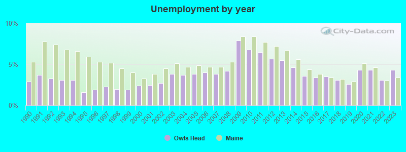
| Here: | 4.3% |
| Maine: | 3.4% |
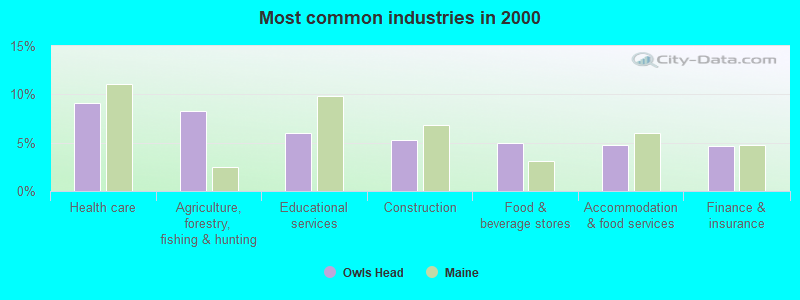
- Health care (9.1%)
- Agriculture, forestry, fishing & hunting (8.3%)
- Educational services (6.0%)
- Construction (5.2%)
- Food & beverage stores (5.0%)
- Accommodation & food services (4.7%)
- Finance & insurance (4.6%)
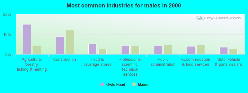
- Agriculture, forestry, fishing & hunting (15.1%)
- Construction (9.1%)
- Food & beverage stores (5.3%)
- Professional, scientific, technical services (4.5%)
- Public administration (4.5%)
- Accommodation & food services (4.0%)
- Motor vehicle & parts dealers (3.5%)
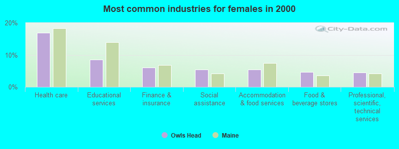
- Health care (16.9%)
- Educational services (8.6%)
- Finance & insurance (6.0%)
- Social assistance (5.5%)
- Accommodation & food services (5.5%)
- Food & beverage stores (4.7%)
- Professional, scientific, technical services (4.4%)
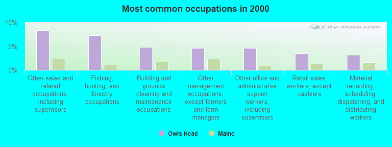
- Other sales and related occupations, including supervisors (8.3%)
- Fishing, hunting, and forestry occupations (7.3%)
- Building and grounds cleaning and maintenance occupations (4.9%)
- Other management occupations, except farmers and farm managers (4.6%)
- Other office and administrative support workers, including supervisors (4.6%)
- Retail sales workers, except cashiers (3.5%)
- Material recording, scheduling, dispatching, and distributing workers (3.2%)
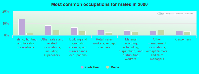
- Fishing, hunting, and forestry occupations (13.9%)
- Other sales and related occupations, including supervisors (8.3%)
- Building and grounds cleaning and maintenance occupations (6.5%)
- Retail sales workers, except cashiers (4.3%)
- Material recording, scheduling, dispatching, and distributing workers (4.0%)
- Other management occupations, except farmers and farm managers (3.8%)
- Carpenters (3.8%)

- Other sales and related occupations, including supervisors (8.3%)
- Other office and administrative support workers, including supervisors (6.5%)
- Other management occupations, except farmers and farm managers (5.5%)
- Secretaries and administrative assistants (5.2%)
- Bookkeeping, accounting, and auditing clerks (5.2%)
- Financial clerks, except bookkeeping, accounting and auditing clerks (4.7%)
- Other teachers, instructors, education, training, and library occupations (3.6%)
Average climate in Owls Head, Maine
Based on data reported by over 4,000 weather stations


Earthquake activity:
Owls Head-area historical earthquake activity is significantly above Maine state average. It is 78% smaller than the overall U.S. average.On 10/16/2012 at 23:12:25, a magnitude 4.7 (4.7 ML, Depth: 10.0 mi, Class: Light, Intensity: IV - V) earthquake occurred 85.3 miles away from the city center
On 4/20/2002 at 10:50:47, a magnitude 5.3 (5.3 ML, Depth: 3.0 mi, Class: Moderate, Intensity: VI - VII) earthquake occurred 230.9 miles away from the city center
On 1/19/1982 at 00:14:42, a magnitude 4.7 (4.5 MB, 4.7 MD, 4.5 LG) earthquake occurred 132.0 miles away from Owls Head center
On 4/20/2002 at 10:50:47, a magnitude 5.2 (5.2 MB, 4.2 MS, 5.2 MW, 5.0 MW) earthquake occurred 231.7 miles away from the city center
On 10/7/1983 at 10:18:46, a magnitude 5.3 (5.1 MB, 5.3 LG, 5.1 ML) earthquake occurred 262.1 miles away from Owls Head center
On 2/26/1999 at 03:38:43, a magnitude 3.8 (3.8 LG, Depth: 2.0 mi, Class: Light, Intensity: II - III) earthquake occurred 36.1 miles away from the city center
Magnitude types: regional Lg-wave magnitude (LG), body-wave magnitude (MB), duration magnitude (MD), local magnitude (ML), surface-wave magnitude (MS), moment magnitude (MW)
Natural disasters:
The number of natural disasters in Knox County (23) is greater than the US average (15).Major Disasters (Presidential) Declared: 18
Emergencies Declared: 4
Causes of natural disasters: Floods: 16, Storms: 12, Winter Storms: 4, Snows: 3, Hurricanes: 2, Blizzard: 1, Heavy Rain: 1, Ice Storm: 1, Landslide: 1, Mudslide: 1, Snowfall: 1, Wind: 1, Other: 1 (Note: some incidents may be assigned to more than one category).
Hospitals and medical centers near Owls Head:
- KNO-WAL-LIN HOMECARE AND HOSPICE (Home Health Center, about 4 miles away; ROCKLAND, ME)
- KNOX CENTER FOR LONG TERM CARE (Nursing Home, about 4 miles away; ROCKLAND, ME)
- KNOX CENTER FOR LTC (Nursing Home, about 4 miles away; ROCKLAND, ME)
- SHORE VILLAGE REHAB AND NURSING (Nursing Home, about 5 miles away; ROCKLAND, ME)
- CAMDEN COMM HOSP HC CENTR (Nursing Home, about 10 miles away; CAMDEN, ME)
- WINDWARD GARDENS (Nursing Home, about 10 miles away; CAMDEN, ME)
- FIELDCREST MANOR (Nursing Home, about 16 miles away; WALDOBORO, ME)
Colleges/universities with over 2000 students nearest to Owls Head:
- University of Maine at Augusta (about 41 miles; Augusta, ME; Full-time enrollment: 3,204)
- Husson University (about 55 miles; Bangor, ME; FT enrollment: 2,421)
- University of Maine (about 61 miles; Orono, ME; FT enrollment: 8,931)
- Southern Maine Community College (about 65 miles; South Portland, ME; FT enrollment: 4,666)
- University of Southern Maine (about 67 miles; Portland, ME; FT enrollment: 6,647)
- University of Maine at Farmington (about 68 miles; Farmington, ME; FT enrollment: 2,036)
- Saint Joseph's College of Maine (about 73 miles; Standish, ME; FT enrollment: 2,010)
Public elementary/middle school in Owls Head:
- OWLS HEAD CENTRAL SCHOOL (Location: 54 ASH POINT DRIVE, Grades: 3-5)
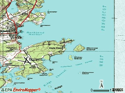
Points of interest:
Notable locations in Owls Head: Owls Head Transportation Museum (A), Bancroft Summer School Camp (B), Owls Head Volunteer Fire Department (C), Owls Head Light Station (D). Display/hide their locations on the map
Church in Owls Head: Owls Head Baptist Church (A). Display/hide its location on the map
Cemeteries: Ginns Point Cemetery (1), Head of Bay Cemetery (2), Hall Cemetery (3). Display/hide their locations on the map
Park in Owls Head: Owls Head State Park (1). Display/hide its location on the map
Beach: Lucia Beach (A). Display/hide its location on the map
Drinking water stations with addresses in Owls Head and their reported violations in the past:
OWLS HEAD TRANSPORTATION MUSEUM (Population served: 25, Groundwater):Past monitoring violations:OWLS HEAD TRANSPORTATION MUSEUM 2 (Population served: 25, Groundwater):
- One routine major monitoring violation
Past monitoring violations:
- One routine major monitoring violation
| This town: | 2.1 people |
| Maine: | 2.3 people |
| This town: | 62.7% |
| Whole state: | 62.9% |
| This town: | 6.6% |
| Whole state: | 9.4% |
Likely homosexual households (counted as self-reported same-sex unmarried-partner households)
- Lesbian couples: 0.1% of all households
- Gay men: 0.3% of all households
| This town: | 8.1% |
| Whole state: | 10.9% |
| This town: | 2.5% |
| Whole state: | 4.1% |
3 people in group homes intended for adults in 2010
9 people in other noninstitutional group quarters in 2000
5 people in homes for the mentally retarded in 2000
For population 15 years and over in Owls Head:
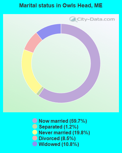
- Never married: 19.8%
- Now married: 59.7%
- Separated: 1.2%
- Widowed: 10.8%
- Divorced: 8.5%
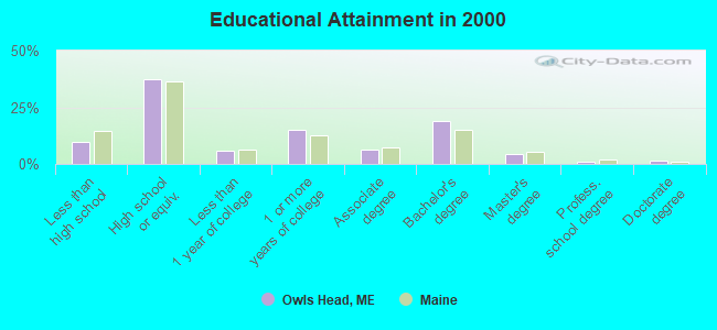
For population 25 years and over in Owls Head:
- High school or higher: 90.1%
- Bachelor's degree or higher: 25.6%
- Graduate or professional degree: 6.9%
- Unemployed: 1.6%
- Mean travel time to work (commute): 16.2 minutes
| Here: | 9.9 |
| Maine average: | 11.2 |
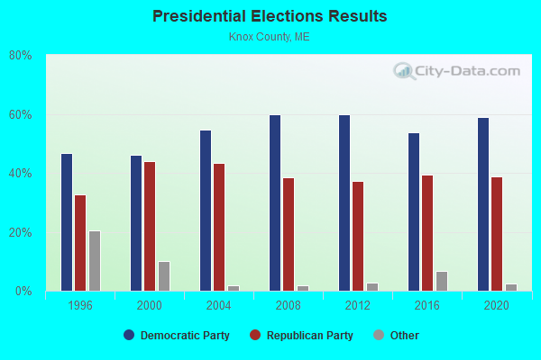
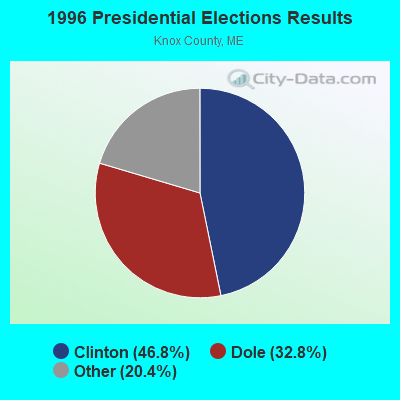
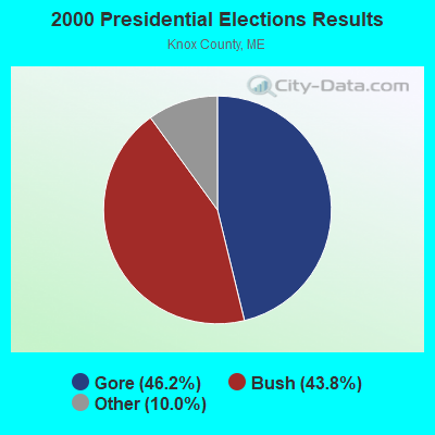


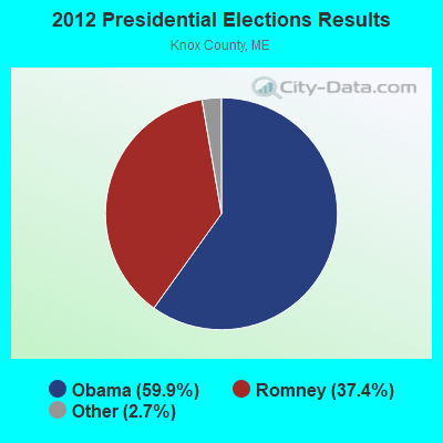
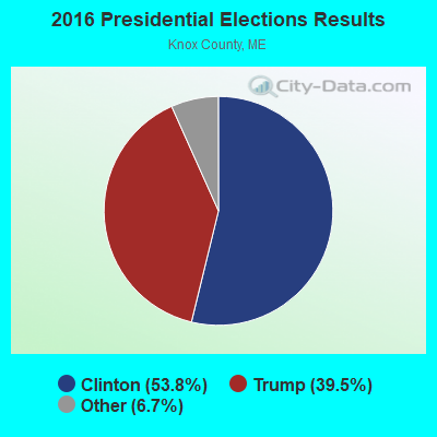
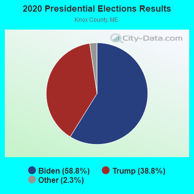
Graphs represent county-level data. Detailed 2008 Election Results
Religion statistics for Owls Head, ME (based on Knox County data)
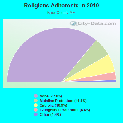
| Religion | Adherents | Congregations |
|---|---|---|
| Mainline Protestant | 4,400 | 29 |
| Catholic | 4,340 | 4 |
| Evangelical Protestant | 1,813 | 23 |
| Other | 569 | 6 |
| None | 28,614 | - |
Food Environment Statistics:
| Here: | 4.17 / 10,000 pop. |
| State: | 2.80 / 10,000 pop. |
| Knox County: | 2.21 / 10,000 pop. |
| State: | 2.20 / 10,000 pop. |
| This county: | 7.37 / 10,000 pop. |
| State: | 5.75 / 10,000 pop. |
| Knox County: | 19.40 / 10,000 pop. |
| State: | 11.02 / 10,000 pop. |
| Knox County: | 7.8% |
| State: | 8.2% |
| Knox County: | 21.6% |
| State: | 25.0% |
Strongest AM radio stations in Owls Head:
- WRKD (1450 AM; 1 kW; ROCKLAND, ME; Owner: CLEAR CHANNEL BROADCASTING LICENSES, INC.)
- WRKO (680 AM; 50 kW; BOSTON, MA; Owner: ENTERCOM BOSTON LICENSE, LLC)
- WSKW (1160 AM; 10 kW; SKOWHEGAN, ME; Owner: MOUNTAIN WIRELESS, INCORPORATED)
- WFAU (1280 AM; 5 kW; GARDINER, ME; Owner: CAPSTAR TX LIMITED PARTNERSHIP)
- WZON (620 AM; 5 kW; BANGOR, ME; Owner: THE ZONE CORPORATION)
- WDEA (1370 AM; 5 kW; ELLSWORTH, ME; Owner: CUMULUS LICENSING CORP.)
- WEEI (850 AM; 50 kW; BOSTON, MA; Owner: ENTERCOM BOSTON LICENSE, LLC)
- WBZ (1030 AM; 50 kW; BOSTON, MA; Owner: INFINITY BROADCASTING OPERATIONS, INC.)
- WTME (780 AM; 10 kW; RUMFORD, ME; Owner: MOUNTAIN VALLEY BROADCASTING, INC.)
- WABI (910 AM; 5 kW; BANGOR, ME; Owner: CLEAR CHANNEL BROADCASTING LICENSES, INC.)
- WMTW (870 AM; 10 kW; GORHAM, ME; Owner: RADIO PARTNERS OF MAINE, L.P.)
- WGAN (560 AM; 5 kW; PORTLAND, ME; Owner: SAGA COMMUNICATIONS OF NEW ENGLAND, LLC)
- WCRN (830 AM; 50 kW; WORCESTER, MA; Owner: CARTER BROADCASTING CORPORATION)
Strongest FM radio stations in Owls Head:
- WMCM (103.3 FM; ROCKLAND, ME; Owner: CLEAR CHANNEL BROADCASTING LICENSES, INC.)
- WBQX (106.9 FM; THOMASTON, ME; Owner: MARINER BROADCASTING LIMITED PARTNER)
- WMEP (90.5 FM; CAMDEN, ME; Owner: MAINE PUBLIC BROADCASTING CORP.)
- WQSS (102.5 FM; CAMDEN, ME; Owner: CLEAR CHANNEL BROADCASTING LICENSES, INC.)
- WFZX (101.7 FM; SEARSPORT, ME; Owner: CLEAR CHANNEL BROADCASTING LICENSES, INC.)
- WBFB (104.7 FM; BELFAST, ME; Owner: CLEAR CHANNEL BROADCASTING LICENSES, INC.)
- WWBX (97.1 FM; BANGOR, ME; Owner: CLEAR CHANNEL BROADCASTING LICENSES, INC.)
- WERU-FM (89.9 FM; BLUE HILL, ME; Owner: SALT POND COMMUNITY B/C COMPANY)
- WBYA (105.5 FM; ISLESBORO, ME; Owner: MARINER BROADCASTING LIMTED PARTNERSHIP)
- WRFR-LP (93.3 FM; ROCKLAND, ME; Owner: PENOBSCOT SCHOOL)
- WCME (96.7 FM; BOOTHBAY HARBOR, ME; Owner: CAPSTAR TX LIMITED PARTNERSHIP)
TV broadcast stations around Owls Head:
- W64BY (Channel 64; ROCKLAND, ME; Owner: CRAIG MINISTRIES, INC.)
Owls Head fatal accident list:
Dec 14, 2004 05:51 PM, Sr-73, Vehicles: 2, Persons: 3, Fatalities: 1, Drunk persons involved: 1
Jun 24, 1997 04:50 PM, Dublinroad, Vehicles: 1, Persons: 5, Fatalities: 1, Drunk persons involved: 1
Oct 30, 1993 01:00 AM, 73, Vehicles: 1, Persons: 2, Fatalities: 1, Drunk persons involved: 1
Sep 14, 1983 10:32 PM, 15291541, Vehicles: 1, Persons: 1, Fatalities: 1
Oct 8, 1983 04:00 AM, 15671568, Vehicles: 1, Persons: 2, Fatalities: 2, Drunk persons involved: 1
Apr 9, 1978 11:58 PM, Vehicles: 1, Persons: 1, Fatalities: 1, Drunk persons involved: 1
FCC Registered Cell Phone Towers:
1- North Shore Dr (Lat: 44.075556 Lon: -69.088611), Type: Tower, Structure height: 42.7 m, Overall height: 46 m, Call Sign: KNKN808
Assigned Frequencies: 880.020 MHz, 880.020 MHz, 880.020 MHz, 835.020 MHz, 835.020 MHz, 835.020 MHz, 891.510 MHz, 891.510 MHz, 891.510 MHz, 846.510 MHz, 846.510 MHz, 846.510 MHzGrant Date: 09/04/2019, Expiration Date: 10/05/2029, Certifier: John T Scott IiiRegistrant: Verizon Wireless, 5055 North Point Pkwy, Np2ne Network Engineering, Alpharetta, GA 30022, Phone: (770) 797-1070, Fax: (770) 797-1036, Email:
FCC Registered Antenna Towers:
4- PETER M CONNOLLY, North Shore Dr (Lat: 44.075556 Lon: -69.088611), Type: 46.0, Overall height: 42.7 m, Registrant: Holland & Knight LLP, Pconnoll@hklaw.Com, , Washi-ngton, Phone: (202) 862-5989
- STEVEN T CAMPBELL, North Shore Dr (Lat: 44.075556 Lon: -69.088611), Type: 46.0, Structure height: 23013 m, Overall height: 42.7 m, Registrant: Holland & Knight LLP, Peter.Connolly@hklaw.Com, , Washi-ngton, Phone: (202) 862-5989
- Cayla Gamble, North Shore Dr (Lat: 44.075556 Lon: -69.088611), Type: 46.0, Structure height: 23013 m, Overall height: 42.7 m, Registrant: Wilkinson Barker Knauer, LLP, Gwerner@wbklaw.Com, , Washi-ngton, Phone: (202) 383-3420
- North Shore Dr (Lat: 44.075556 Lon: -69.088611), Type: 46.0, Overall height: 42.7 m, Registrant: United States Cellular Corporation, Linda.Hartman@koteen.Com, , Washi-ngton, Phone: (202) 467-5700
FCC Registered Microwave Towers:
3- Owls Head, North Shore Dr (Lat: 44.075556 Lon: -69.088611), Type: Tower, Structure height: 42.7 m, Overall height: 46 m, Call Sign: WPSE281, Licensee ID: L00127162,
Assigned Frequencies: 6645.00 MHz, Grant Date: 03/29/2011, Expiration Date: 03/26/2021, Cancellation Date: 03/26/2019, Certifier: John E Rooney, Registrant: Maine Rsa #1, Inc.
- Owls Head, North Shore Dr (Lat: 44.075556 Lon: -69.088611), Type: Tower, Structure height: 42.7 m, Overall height: 46 m, Call Sign: WQFP204,
Assigned Frequencies: 10638.1 MHz, Grant Date: 08/29/2006, Expiration Date: 08/29/2016, Cancellation Date: 02/19/2014, Certifier: Scott Donlea, Registrant: Verizon Wireless, 1120 Sanctuary Pkwy, #150 Gasa5reg, Alpharetta, GA 30009-7630, Phone: (770) 797-1070, Fax: (770) 797-1036, Email:
- Owls Head, 86 Lmnop Road (Lat: 44.075694 Lon: -69.088667), Type: Ltower, Structure height: 43.2 m, Overall height: 44.8 m, Call Sign: WQTJ240,
Assigned Frequencies: 19575.0 MHz, 19575.0 MHz, 19575.0 MHz, 19575.0 MHz, 19575.0 MHz, 19575.0 MHz, 19575.0 MHz, 19575.0 MHz, 19575.0 MHz, Grant Date: 02/12/2014, Expiration Date: 02/12/2024, Cancellation Date: 07/24/2020, Certifier: Jessica B Lyons, Registrant: At&t Services, Inc., 208 S. Akard Street, Room 2100, Dallas, TX 75202, Phone: (855) 699-7073, Email:
FCC Registered Maritime Coast & Aviation Ground Towers:
4- Knox County Regional Airport (Lat: 44.060361 Lon: -69.099750), Type: Building, Overall height: 5 m, Call Sign: KHG7,
Assigned Frequencies: 123.050 MHz, Grant Date: 01/28/2015, Expiration Date: 02/15/2025, Registrant: Knox County Regional Airport, 5 Airport Road, Owls Head, ME 04854, Phone: (207) 594-4131, Fax: (207) 594-0738, Email:
- Main St (Lat: 44.083417 Lon: -69.054472), Type: Building, Overall height: 4 m, Call Sign: WHU392,
Assigned Frequencies: 156.450 MHz, 156.500 MHz, 156.800 MHz, Grant Date: 09/03/1998, Expiration Date: 11/19/2003, Cancellation Date: 01/25/2004, Registrant: Bernard E Raynes, Owls Head, ME 04854
- 19 Airport Rd-Knox County Regional Airport (Lat: 44.062639 Lon: -69.092972), Type: Bant, Structure height: 9 m, Overall height: 10 m, Call Sign: WQJW328,
Assigned Frequencies: 122.775 MHz, Grant Date: 01/21/2009, Expiration Date: 01/21/2019, Cancellation Date: 03/23/2019, Certifier: John Newcomb, Registrant: Aviation Spectrum Resources Inc, 2551 Riva Road, Annapolis, MD 21401, Phone: (410) 266-2132, Fax: (410) 573-3003, Email:
- 117 Museum St (Lat: 44.065194 Lon: -69.099083), Type: Pole, Structure height: 3 m, Call Sign: WRUA858,
Assigned Frequencies: 125.300 MHz, 133.675 MHz, Grant Date: 08/05/2022, Expiration Date: 08/08/2023, Cancellation Date: 10/14/2023, Certifier: Jeremy Shaw, Registrant: 7601 N 181st Ave, Waddell, AZ 85355, Phone: (229) 834-2599, Email:
FCC Registered Amateur Radio Licenses:
18 (See the full list of FCC Registered Amateur Radio Licenses in Owls Head)FAA Registered Aircraft:
27 (See the full list of FAA Registered Aircraft in Owls Head)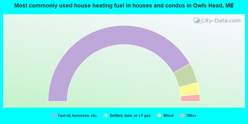
- 83.4%Fuel oil, kerosene, etc.
- 8.6%Bottled, tank, or LP gas
- 5.1%Wood
- 2.2%Electricity
- 0.3%Utility gas
- 0.3%Coal or coke
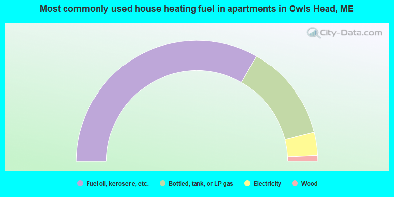
- 66.4%Fuel oil, kerosene, etc.
- 26.0%Bottled, tank, or LP gas
- 6.1%Electricity
- 1.5%Wood
Owls Head compared to Maine state average:
- Unemployed percentage significantly below state average.
- Black race population percentage significantly below state average.
- Hispanic race population percentage significantly below state average.
- Median age significantly above state average.
- Renting percentage below state average.
- Length of stay since moving in significantly above state average.
- Number of rooms per house significantly below state average.
- House age significantly below state average.
- Number of college students below state average.