St. George, Maine
Submit your own pictures of this town and show them to the world
- OSM Map
- General Map
- Google Map
- MSN Map
Population change since 2000: +0.4%
 |
| Males: 1,259 | |
| Females: 1,332 |
| Median resident age: | 51.7 years |
| Maine median age: | 43.0 years |
Zip codes: 04860.
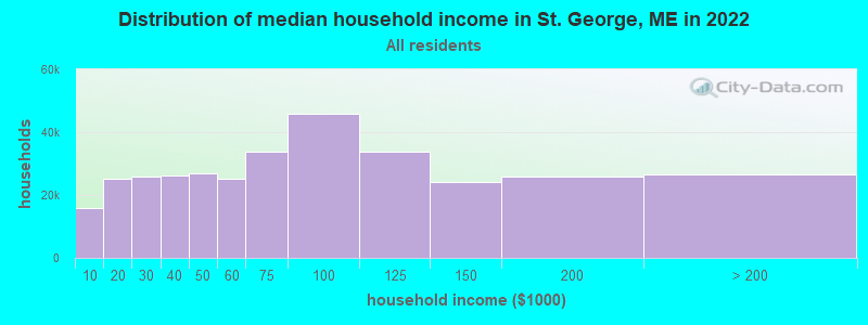
| St. George: | $78,679 |
| ME: | $69,543 |
Estimated per capita income in 2022: $47,562 (it was $23,272 in 2000)
St. George town income, earnings, and wages data
Estimated median house or condo value in 2022: $351,453 (it was $125,100 in 2000)
| St. George: | $351,453 |
| ME: | $290,600 |
Detailed information about poverty and poor residents in St. George, ME
Compare current foreclosures near St. George, ME:
| Photo | Address | Area | Beds / Baths | Price | Details |
|---|---|---|---|---|---|

|
#1
Knott St
Rockland, ME 04841
|
1,678 sq. feet
|
1 baths 3 beds |
show details | |

|
#2
River Rd
Tenants Harbor, ME 04860
|
- sq. feet
|
- baths - beds |
show details | |

|
#3
Philbrick Ave
Rockland, ME 04841
|
- sq. feet
|
- baths - beds |
show details | |

|
#4
Beechwood St
Thomaston, ME 04861
|
- sq. feet
|
- baths - beds |
show details | |

|
#5
Waldoboro Rd
Bremen, ME 04551
|
- sq. feet
|
- baths - beds |
show details | |

|
#6
Genthner Rd
Waldoboro, ME 04572
|
- sq. feet
|
- baths - beds |
show details | |

|
#7
S Union Rd
Union, ME 04862
|
- sq. feet
|
- baths - beds |
show details | |

|
Check over 1 million property listings on Foreclosure.com!
|
browse all offers | |||

- 2,54898.3%White alone
- 220.8%Two or more races
- 130.5%Hispanic
- 50.2%Black alone
- 30.1%Asian alone
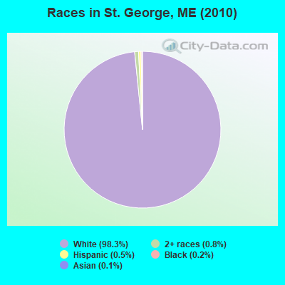
Races in St. George detailed stats: ancestries, foreign born residents, place of birth
 Recent articles from our blog. Our writers, many of them Ph.D. graduates or candidates, create easy-to-read articles on a wide variety of topics.

 | Lake St. George in Liberty Maine (4 replies) |
| Summertime in St. George (5 replies) |
| Anyone from Rockland ? (24 replies) |
| Less Touristy coastal towns? (32 replies) |
| Belfast ME....Good Area??? (10 replies) |
| Re - Locating back to Maine (13 replies) |
Latest news from St. George, ME collected exclusively by city-data.com from local newspapers, TV, and radio stations
Ancestries: English (26.6%), Irish (11.9%), German (9.1%), Scottish (4.9%), French (4.9%), Swedish (4.4%).
Current Local Time: EST time zone
Incorporated on 02/07/1803
Elevation: 113 feet
Land area: 25.6 square miles.
Population density: 101 people per square mile (very low).
40 residents are foreign born
| This town: | 1.6% |
| Maine: | 2.9% |
| St. George town: | 1.0% ($1,309) |
| Maine: | 1.5% ($1,417) |
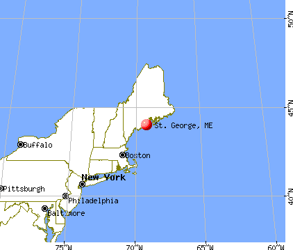
Nearest city with pop. 50,000+: Portland, ME  (57.2 miles , pop. 64,249).
Nearest city with pop. 200,000+: Boston, MA (148.4 miles , pop. 589,141).
Nearest city with pop. 1,000,000+: Bronx, NY (321.6 miles , pop. 1,332,650).
Nearest cities:
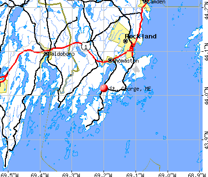
), ), ), )Latitude: 43.97 N, Longitude: 69.20 W
Area code commonly used in this area: 207

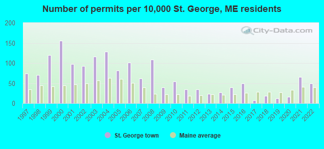
Single-family new house construction building permits:
- 2022: 13 buildings, average cost: $30,100
- 2021: 17 buildings, average cost: $303,700
- 2020: 4 buildings, average cost: $235,500
- 2019: 3 buildings, average cost: $923,000
- 2018: 5 buildings, average cost: $572,000
- 2017: 2 buildings, average cost: $775,400
- 2016: 13 buildings, average cost: $283,900
- 2015: 10 buildings, average cost: $321,400
- 2014: 7 buildings, average cost: $251,100
- 2013: 6 buildings, average cost: $315,000
- 2012: 9 buildings, average cost: $384,300
- 2011: 9 buildings, average cost: $208,900
- 2010: 14 buildings, average cost: $244,400
- 2009: 10 buildings, average cost: $144,500
- 2008: 28 buildings, average cost: $247,000
- 2007: 16 buildings, average cost: $256,300
- 2006: 26 buildings, average cost: $187,200
- 2005: 21 buildings, average cost: $182,400
- 2004: 33 buildings, average cost: $230,300
- 2003: 30 buildings, average cost: $176,700
- 2002: 24 buildings, average cost: $168,500
- 2001: 25 buildings, average cost: $105,300
- 2000: 40 buildings, average cost: $132,700
- 1999: 31 buildings, average cost: $116,900
- 1998: 18 buildings, average cost: $123,800
- 1997: 19 buildings, average cost: $94,100

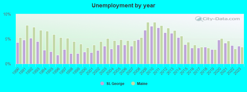
| Here: | 3.6% |
| Maine: | 3.4% |

- Agriculture, forestry, fishing & hunting (13.4%)
- Health care (8.8%)
- Accommodation & food services (7.3%)
- Educational services (6.8%)
- Construction (6.3%)
- Public administration (4.5%)
- Professional, scientific, technical services (4.0%)
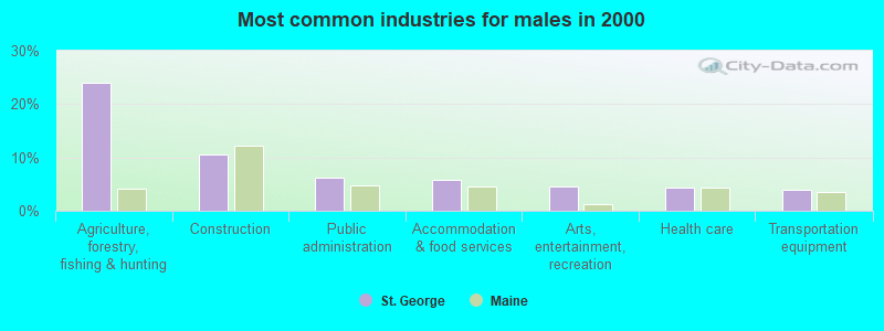
- Agriculture, forestry, fishing & hunting (24.0%)
- Construction (10.5%)
- Public administration (6.1%)
- Accommodation & food services (5.8%)
- Arts, entertainment, recreation (4.5%)
- Health care (4.3%)
- Transportation equipment (3.9%)

- Educational services (15.0%)
- Health care (14.3%)
- Accommodation & food services (9.2%)
- Professional, scientific, technical services (7.1%)
- Finance & insurance (3.8%)
- U. S. Postal service (3.7%)
- Food & beverage stores (3.3%)

- Fishing, hunting, and forestry occupations (12.0%)
- Other management occupations, except farmers and farm managers (4.9%)
- Other office and administrative support workers, including supervisors (4.5%)
- Other production occupations, including supervisors (4.5%)
- Building and grounds cleaning and maintenance occupations (3.6%)
- Registered nurses (3.4%)
- Other sales and related occupations, including supervisors (3.1%)

- Fishing, hunting, and forestry occupations (21.7%)
- Other management occupations, except farmers and farm managers (5.4%)
- Building and grounds cleaning and maintenance occupations (4.2%)
- Other production occupations, including supervisors (3.9%)
- Carpenters (3.3%)
- Laborers and material movers, hand (3.0%)
- Construction traders workers except carpenters, electricians, painters, plumbers, and construction laborers (2.7%)

- Other office and administrative support workers, including supervisors (7.7%)
- Registered nurses (6.0%)
- Secretaries and administrative assistants (5.3%)
- Preschool, kindergarten, elementary, and middle school teachers (5.1%)
- Other production occupations, including supervisors (5.1%)
- Other management occupations, except farmers and farm managers (4.4%)
- Bookkeeping, accounting, and auditing clerks (4.2%)
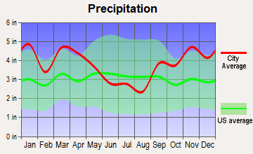
Average climate in St. George, Maine
Based on data reported by over 4,000 weather stations


Earthquake activity:
St. George-area historical earthquake activity is significantly above Maine state average. It is 78% smaller than the overall U.S. average.On 10/16/2012 at 23:12:25, a magnitude 4.7 (4.7 ML, Depth: 10.0 mi, Class: Light, Intensity: IV - V) earthquake occurred 76.9 miles away from St. George center
On 4/20/2002 at 10:50:47, a magnitude 5.3 (5.3 ML, Depth: 3.0 mi, Class: Moderate, Intensity: VI - VII) earthquake occurred 225.8 miles away from St. George center
On 1/19/1982 at 00:14:42, a magnitude 4.7 (4.5 MB, 4.7 MD, 4.5 LG) earthquake occurred 124.1 miles away from the city center
On 4/20/2002 at 10:50:47, a magnitude 5.2 (5.2 MB, 4.2 MS, 5.2 MW, 5.0 MW) earthquake occurred 226.6 miles away from St. George center
On 10/7/1983 at 10:18:46, a magnitude 5.3 (5.1 MB, 5.3 LG, 5.1 ML) earthquake occurred 255.8 miles away from the city center
On 2/26/1999 at 03:38:43, a magnitude 3.8 (3.8 LG, Depth: 2.0 mi, Class: Light, Intensity: II - III) earthquake occurred 38.7 miles away from the city center
Magnitude types: regional Lg-wave magnitude (LG), body-wave magnitude (MB), duration magnitude (MD), local magnitude (ML), surface-wave magnitude (MS), moment magnitude (MW)
Natural disasters:
The number of natural disasters in Knox County (23) is greater than the US average (15).Major Disasters (Presidential) Declared: 18
Emergencies Declared: 4
Causes of natural disasters: Floods: 16, Storms: 12, Winter Storms: 4, Snows: 3, Hurricanes: 2, Blizzard: 1, Heavy Rain: 1, Ice Storm: 1, Landslide: 1, Mudslide: 1, Snowfall: 1, Wind: 1, Other: 1 (Note: some incidents may be assigned to more than one category).

Hospitals and medical centers near St. George:
- KNO-WAL-LIN HOMECARE AND HOSPICE (Home Health Center, about 10 miles away; ROCKLAND, ME)
- KNOX CENTER FOR LONG TERM CARE (Nursing Home, about 11 miles away; ROCKLAND, ME)
- KNOX CENTER FOR LTC (Nursing Home, about 11 miles away; ROCKLAND, ME)
- SHORE VILLAGE REHAB AND NURSING (Nursing Home, about 12 miles away; ROCKLAND, ME)
- FIELDCREST MANOR (Nursing Home, about 14 miles away; WALDOBORO, ME)
Colleges/universities with over 2000 students nearest to St. George:
- University of Maine at Augusta (about 39 miles; Augusta, ME; Full-time enrollment: 3,204)
- Southern Maine Community College (about 56 miles; South Portland, ME; FT enrollment: 4,666)
- University of Southern Maine (about 58 miles; Portland, ME; FT enrollment: 6,647)
- Husson University (about 63 miles; Bangor, ME; FT enrollment: 2,421)
- Saint Joseph's College of Maine (about 65 miles; Standish, ME; FT enrollment: 2,010)
- University of Maine at Farmington (about 68 miles; Farmington, ME; FT enrollment: 2,036)
- University of New England (about 69 miles; Biddeford, ME; FT enrollment: 4,539)
Points of interest:
Notable locations in St. George: Saint George Volunteer Fire Department Tenants Harbor (A), Jackson Memorial Library (B), Saint George Volunteer Fire Department Port Clyde Station (C), Saint George Volunteer Fire Department Substation (D). Display/hide their locations on the map
Churches in St. George include: Ridge Church (A), Harmony Bible Baptist Church (B). Display/hide their locations on the map
Cemeteries: North Parish Cemeteries (1), Seaside Cemetery (2), Hillside Cemetery (3). Display/hide their locations on the map
Lakes: Howard Pond (A), The Marsh (B). Display/hide their locations on the map
| This town: | 2.1 people |
| Maine: | 2.3 people |
| This town: | 63.8% |
| Whole state: | 62.9% |
| This town: | 9.8% |
| Whole state: | 9.4% |
Likely homosexual households (counted as self-reported same-sex unmarried-partner households)
- Lesbian couples: 0.4% of all households
- Gay men: 0.2% of all households
| This town: | 8.6% |
| Whole state: | 10.9% |
| This town: | 3.0% |
| Whole state: | 4.1% |
For population 15 years and over in St. George:
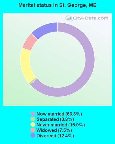
- Never married: 16.0%
- Now married: 63.3%
- Separated: 0.8%
- Widowed: 7.5%
- Divorced: 12.4%
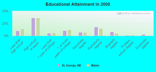
For population 25 years and over in St. George:
- High school or higher: 89.8%
- Bachelor's degree or higher: 30.0%
- Graduate or professional degree: 12.2%
- Unemployed: 3.1%
- Mean travel time to work (commute): 23.0 minutes
| Here: | 11.4 |
| Maine average: | 11.2 |
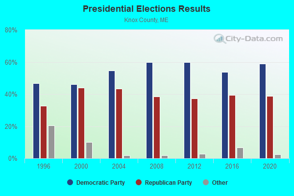
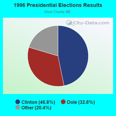
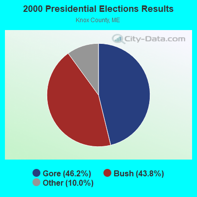


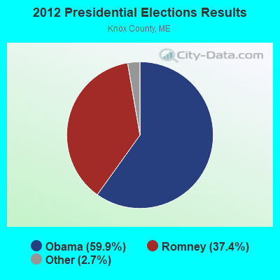

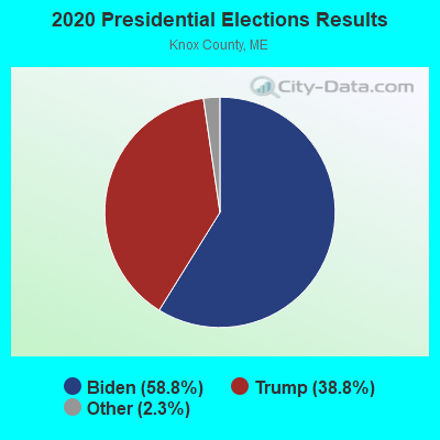
Graphs represent county-level data. Detailed 2008 Election Results
Religion statistics for St. George, ME (based on Knox County data)
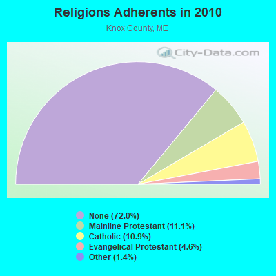
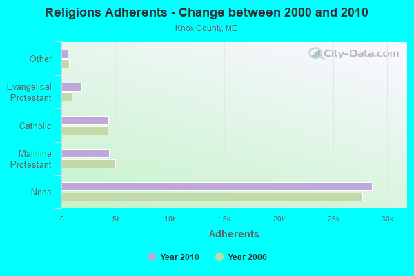
| Religion | Adherents | Congregations |
|---|---|---|
| Mainline Protestant | 4,400 | 29 |
| Catholic | 4,340 | 4 |
| Evangelical Protestant | 1,813 | 23 |
| Other | 569 | 6 |
| None | 28,614 | - |
Food Environment Statistics:
| Knox County: | 4.17 / 10,000 pop. |
| Maine: | 2.80 / 10,000 pop. |
| This county: | 2.21 / 10,000 pop. |
| Maine: | 2.20 / 10,000 pop. |
| Knox County: | 7.37 / 10,000 pop. |
| State: | 5.75 / 10,000 pop. |
| Knox County: | 19.40 / 10,000 pop. |
| Maine: | 11.02 / 10,000 pop. |
| This county: | 7.8% |
| Maine: | 8.2% |
| Knox County: | 21.6% |
| Maine: | 25.0% |
Strongest AM radio stations in St. George:
- WRKD (1450 AM; 1 kW; ROCKLAND, ME; Owner: CLEAR CHANNEL BROADCASTING LICENSES, INC.)
- WRKO (680 AM; 50 kW; BOSTON, MA; Owner: ENTERCOM BOSTON LICENSE, LLC)
- WFAU (1280 AM; 5 kW; GARDINER, ME; Owner: CAPSTAR TX LIMITED PARTNERSHIP)
- WSKW (1160 AM; 10 kW; SKOWHEGAN, ME; Owner: MOUNTAIN WIRELESS, INCORPORATED)
- WMTW (870 AM; 10 kW; GORHAM, ME; Owner: RADIO PARTNERS OF MAINE, L.P.)
- WGAN (560 AM; 5 kW; PORTLAND, ME; Owner: SAGA COMMUNICATIONS OF NEW ENGLAND, LLC)
- WEEI (850 AM; 50 kW; BOSTON, MA; Owner: ENTERCOM BOSTON LICENSE, LLC)
- WBZ (1030 AM; 50 kW; BOSTON, MA; Owner: INFINITY BROADCASTING OPERATIONS, INC.)
- WTME (780 AM; 10 kW; RUMFORD, ME; Owner: MOUNTAIN VALLEY BROADCASTING, INC.)
- WZON (620 AM; 5 kW; BANGOR, ME; Owner: THE ZONE CORPORATION)
- WCRN (830 AM; 50 kW; WORCESTER, MA; Owner: CARTER BROADCASTING CORPORATION)
- WKOX (1200 AM; 50 kW; FRAMINGHAM, MA; Owner: CAPSTAR TX LIMITED PARTNERSHIP)
- WNNZ (640 AM; 50 kW; WESTFIELD, MA; Owner: CLEAR CHANNEL BROADCASTING LICENSES, INC.)
Strongest FM radio stations in St. George:
- WMCM (103.3 FM; ROCKLAND, ME; Owner: CLEAR CHANNEL BROADCASTING LICENSES, INC.)
- WBQX (106.9 FM; THOMASTON, ME; Owner: MARINER BROADCASTING LIMITED PARTNER)
- WMEP (90.5 FM; CAMDEN, ME; Owner: MAINE PUBLIC BROADCASTING CORP.)
- WQSS (102.5 FM; CAMDEN, ME; Owner: CLEAR CHANNEL BROADCASTING LICENSES, INC.)
- WFZX (101.7 FM; SEARSPORT, ME; Owner: CLEAR CHANNEL BROADCASTING LICENSES, INC.)
- WCME (96.7 FM; BOOTHBAY HARBOR, ME; Owner: CAPSTAR TX LIMITED PARTNERSHIP)
- WBFB (104.7 FM; BELFAST, ME; Owner: CLEAR CHANNEL BROADCASTING LICENSES, INC.)
TV broadcast stations around St. George:
- W64BY (Channel 64; ROCKLAND, ME; Owner: CRAIG MINISTRIES, INC.)
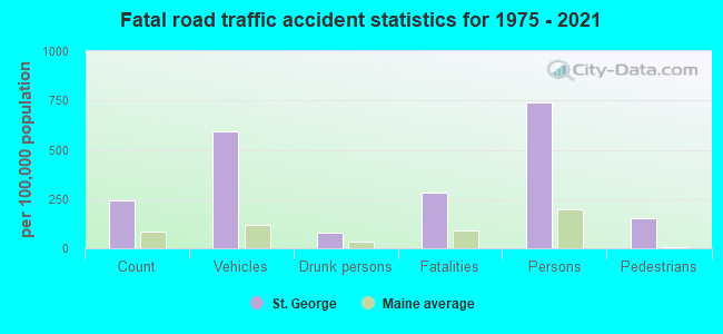
St. George fatal accident list:
Nov 14, 2009 05:00 AM, Wallston Road, Lat: 43.966442, Lon: -69.217386, Vehicles: 1, Persons: 1, Fatalities: 1, Drunk persons involved: 1
Feb 16, 2007 01:45 PM, Sr-131, Lat: 43.998708, Lon: -69.211736, Vehicles: 2, Persons: 2, Fatalities: 1
Jul 24, 1996 11:30 PM, Wallaston, Vehicles: 1, Persons: 5, Fatalities: 1
Jan 24, 1989 09:30 AM, 60106011, Vehicles: 2, Persons: 3, Fatalities: 1
Feb 2, 1980 01:05 AM, Vehicles: 1, Persons: 4, Fatalities: 2, Drunk persons involved: 1
- National Bridge Inventory (NBI) Statistics
- 1Number of bridges
- 3ft / 0.6mTotal length
- 102,000Total average daily traffic
- 5,100Total average daily truck traffic
- 480Total future (year 2036) average daily traffic
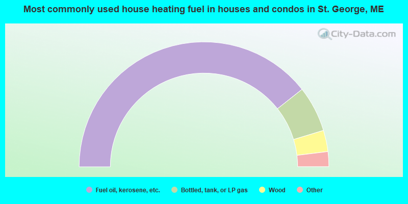
- 78.8%Fuel oil, kerosene, etc.
- 11.9%Bottled, tank, or LP gas
- 5.5%Wood
- 3.6%Electricity
- 0.3%Solar energy
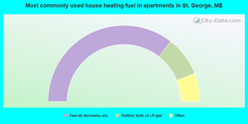
- 71.1%Fuel oil, kerosene, etc.
- 16.9%Bottled, tank, or LP gas
- 3.6%Coal or coke
- 3.6%Wood
- 2.4%Utility gas
- 2.4%Electricity
St. George compared to Maine state average:
- Unemployed percentage significantly below state average.
- Black race population percentage significantly below state average.
- Hispanic race population percentage significantly below state average.
- Median age significantly above state average.
- Foreign-born population percentage significantly below state average.
- Renting percentage below state average.
- Length of stay since moving in significantly above state average.
- Number of rooms per house significantly below state average.
- House age significantly below state average.
- Number of college students below state average.

|
Total of 4 patent applications in 2008-2024.