Rutland, Vermont
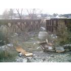
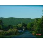
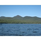
Rutland: View in Rutland
Rutland: View in Rutland
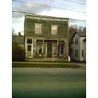
Rutland: Rutland
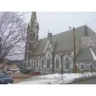
Rutland: Church in Rutland
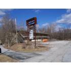
Rutland: Flory's Motel
Rutland: Chittenden Dam, Rutland County
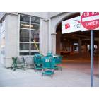
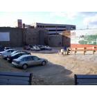
Rutland: Transit Center
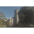
Rutland: Trinity Church - Rutland, VT
Rutland: Center Street
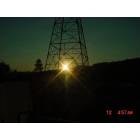
Rutland: Rutland Sunrise
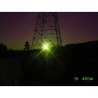
Rutland: Sun Rise
- add
your
Submit your own pictures of this city and show them to the world
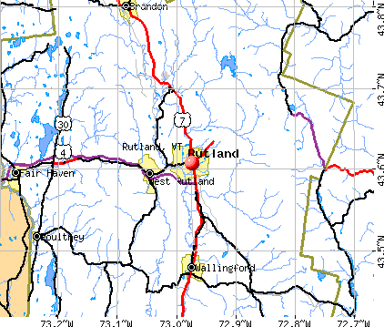
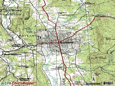
- OSM Map
- General Map
- Google Map
- MSN Map
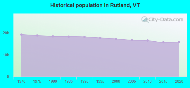
Population change since 2000: -9.2%
 |
| Males: 8,277 | |
| Females: 7,418 |
| Median resident age: | 50.0 years |
| Vermont median age: | 43.2 years |
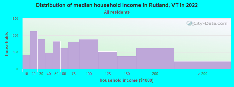
| Rutland: | $53,287 |
| VT: | $73,991 |
Estimated per capita income in 2022: $35,543 (it was $17,075 in 2000)
Rutland city income, earnings, and wages data
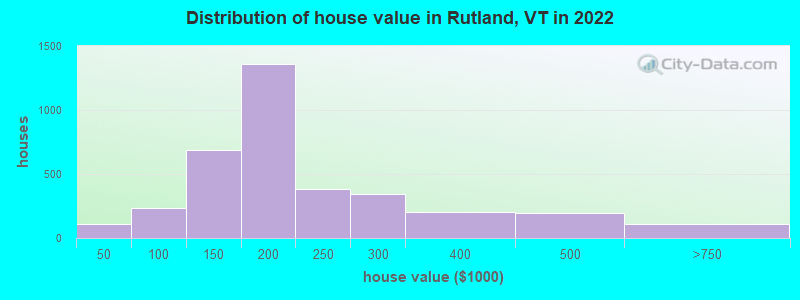
Estimated median house or condo value in 2022: $189,822 (it was $89,100 in 2000)
| Rutland: | $189,822 |
| VT: | $304,700 |
Mean prices in 2022: all housing units: $257,771; detached houses: $269,386; townhouses or other attached units: $249,199; in 2-unit structures: $226,629; in 3-to-4-unit structures: $286,566; in 5-or-more-unit structures: $152,452; mobile homes: $57,072
Median gross rent in 2022: $850.
(14.8% for White Non-Hispanic residents, 17.3% for Black residents, 19.0% for Hispanic or Latino residents, 2.2% for two or more races residents)
Detailed information about poverty and poor residents in Rutland, VT


Compare current foreclosures near Rutland, VT:
| Photo | Address | Area | Beds / Baths | Price | Details |
|---|---|---|---|---|---|

|
#1
Columbian Ave Apt 2
Rutland, VT 05701
|
- sq. feet
|
- baths - beds |
show details | |

|
#2
1/2 State St, # 2
Rutland, VT 05701
|
- sq. feet
|
- baths - beds |
show details | |

|
#3
Pine St # 5
Rutland, VT 05701
|
- sq. feet
|
- baths - beds |
show details | |

|
#4
Regency Mnr Apt 13-4
Rutland, VT 05701
|
- sq. feet
|
- baths - beds |
show details | |

|
#5
Hillcrest Rd
Rutland, VT 05701
|
- sq. feet
|
- baths - beds |
show details | |

|
#6
Commons St # C
Rutland, VT 05701
|
- sq. feet
|
- baths - beds |
show details | |

|
#7
Eastview Ct
Rutland, VT 05701
|
- sq. feet
|
- baths - beds |
show details | |

|
#8
Davis St
Rutland, VT 05701
|
- sq. feet
|
- baths - beds |
show details | |

|
#9
Evergreen Ave
Rutland, VT 05701
|
- sq. feet
|
- baths - beds |
show details | |

|
#10
Stratton Rd
Rutland, VT 05701
|
- sq. feet
|
- baths - beds |
show details |
| Photo | Address | Area | Beds / Baths | Price | Details |
|---|---|---|---|---|---|

|
#11
Bellevue Ave
Rutland, VT 05701
|
- sq. feet
|
- baths - beds |
show details | |

|
#12
Clematis Ave
Rutland, VT 05701
|
- sq. feet
|
- baths - beds |
show details | |

|
#13
Woodward Rd
Rutland, VT 05701
|
- sq. feet
|
- baths - beds |
show details | |

|
#14
Watkins Ave
Rutland, VT 05701
|
- sq. feet
|
- baths - beds |
show details | |

|
#15
Library Ave
Rutland, VT 05701
|
- sq. feet
|
- baths - beds |
show details | |

|
#16
Woodward Rd
Rutland, VT 05701
|
- sq. feet
|
- baths - beds |
show details | |

|
#17
Furnace St
Fair Haven, VT 05743
|
3,160 sq. feet
|
3 baths 7 beds |
show details | |

|
#18
County Route 20
Hampton, NY 12837
|
1,364 sq. feet
|
2 baths 2 beds |
show details | |

|
#19
Castleton Meadows Ln Apt 6b
Castleton, VT 05735
|
- sq. feet
|
- baths - beds |
show details | |

|
#20
Caernarvon St
Fair Haven, VT 05743
|
- sq. feet
|
- baths - beds |
show details |
| Photo | Address | Area | Beds / Baths | Price | Details |
|---|---|---|---|---|---|

|
#21
Sawyer Hill Rd
Mount Holly, VT 05758
|
- sq. feet
|
- baths - beds |
show details | |

|
#22
Knipes Dr
North Clarendon, VT 05759
|
- sq. feet
|
- baths - beds |
show details | |

|
#23
Mountain View Rd
Wallingford, VT 05773
|
- sq. feet
|
- baths - beds |
show details | |

|
#24
Belgo Rd
Castleton, VT 05735
|
- sq. feet
|
- baths - beds |
show details | |

|
#25
Pleasant St
West Rutland, VT 05777
|
- sq. feet
|
- baths - beds |
show details | |

|
#26
Dillon Rd
Ludlow, VT 05149
|
- sq. feet
|
- baths - beds |
show details | |

|
Check over 1 million property listings on Foreclosure.com!
|
browse all offers | |||


- 14,68792.4%White alone
- 5283.3%Two or more races
- 3582.3%Hispanic
- 1861.2%Asian alone
- 780.5%Black alone
- 30.02%American Indian alone
- 30.02%Other race alone
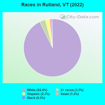
Races in Rutland detailed stats: ancestries, foreign born residents, place of birth
According to our research of Vermont and other state lists, there were 86 registered sex offenders living in Rutland, Vermont as of April 27, 2024.
The ratio of all residents to sex offenders in Rutland is 185 to 1.
Type |
2009 |
2010 |
2011 |
2012 |
2013 |
2014 |
2015 |
2016 |
2017 |
2018 |
2019 |
2020 |
2021 |
2022 |
|---|---|---|---|---|---|---|---|---|---|---|---|---|---|---|
| Murders (per 100,000) | 0 (0.0) | 0 (0.0) | 0 (0.0) | 0 (0.0) | 0 (0.0) | 0 (0.0) | 0 (0.0) | 0 (0.0) | 1 (6.5) | 0 (0.0) | 0 (0.0) | 0 (0.0) | 1 (6.8) | 1 (6.3) |
| Rapes (per 100,000) | 7 (41.9) | 2 (12.1) | 4 (24.2) | 3 (18.3) | 5 (31.0) | 5 (31.2) | 3 (19.0) | 5 (31.9) | 9 (58.2) | 6 (39.2) | 13 (85.6) | 8 (53.6) | 8 (54.2) | 5 (31.5) |
| Robberies (per 100,000) | 23 (137.8) | 4 (24.2) | 14 (84.8) | 12 (73.2) | 6 (37.2) | 13 (81.0) | 3 (19.0) | 1 (6.4) | 9 (58.2) | 6 (39.2) | 5 (32.9) | 7 (46.9) | 19 (128.6) | 13 (82.0) |
| Assaults (per 100,000) | 45 (269.7) | 46 (278.9) | 41 (248.3) | 39 (238.0) | 51 (316.0) | 38 (236.8) | 40 (252.9) | 53 (337.6) | 70 (452.7) | 58 (379.1) | 49 (322.6) | 35 (234.4) | 47 (318.2) | 57 (359.4) |
| Burglaries (per 100,000) | 156 (934.8) | 165 (1,000) | 248 (1,502) | 210 (1,281) | 199 (1,233) | 111 (691.8) | 59 (373.1) | 90 (573.3) | 108 (698.5) | 56 (366.0) | 65 (427.9) | 40 (267.9) | 84 (568.7) | 39 (245.9) |
| Thefts (per 100,000) | 735 (4,404) | 643 (3,898) | 817 (4,948) | 850 (5,187) | 789 (4,889) | 505 (3,148) | 344 (2,175) | 309 (1,968) | 436 (2,820) | 316 (2,065) | 329 (2,166) | 268 (1,795) | 435 (2,945) | 711 (4,484) |
| Auto thefts (per 100,000) | 26 (155.8) | 13 (78.8) | 28 (169.6) | 20 (122.0) | 24 (148.7) | 9 (56.1) | 14 (88.5) | 19 (121.0) | 10 (64.7) | 17 (111.1) | 21 (138.2) | 19 (127.3) | 39 (264.0) | 20 (126.1) |
| Arson (per 100,000) | 6 (36.0) | 2 (12.1) | 2 (12.1) | 2 (12.2) | 0 (0.0) | 2 (12.5) | 1 (6.3) | 2 (12.7) | 1 (6.5) | 3 (19.6) | 6 (39.5) | 5 (33.5) | 3 (20.3) | 3 (18.9) |
| City-Data.com crime index | 382.9 | 305.0 | 411.1 | 391.1 | 392.9 | 275.4 | 191.7 | 223.5 | 334.4 | 236.1 | 270.5 | 204.6 | 337.8 | 341.0 |
The City-Data.com crime index weighs serious crimes and violent crimes more heavily. Higher means more crime, U.S. average is 246.1. It adjusts for the number of visitors and daily workers commuting into cities.
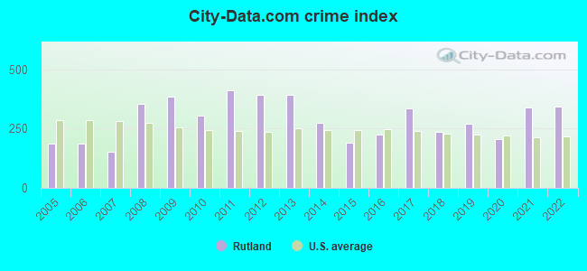
Crime rate in Rutland detailed stats: murders, rapes, robberies, assaults, burglaries, thefts, arson
Full-time law enforcement employees in 2021, including police officers: 4 (4 officers - 3 male; 1 female).
| Officers per 1,000 residents here: | 0.97 |
| Vermont average: | 1.69 |
 Recent articles from our blog. Our writers, many of them Ph.D. graduates or candidates, create easy-to-read articles on a wide variety of topics.


Latest news from Rutland, VT collected exclusively by city-data.com from local newspapers, TV, and radio stations
Ancestries: English (22.2%), Irish (13.9%), Italian (11.1%), French (10.4%), American (8.9%), Polish (5.7%).
Current Local Time: EST time zone
Elevation: 648 feet
Land area: 7.64 square miles.
Population density: 2,055 people per square mile (low).
340 residents are foreign born (1.1% Asia, 0.4% Europe, 0.4% Latin America).
| This city: | 2.1% |
| Vermont: | 4.4% |
Median real estate property taxes paid for housing units with mortgages in 2022: $4,395 (2.3%)
Median real estate property taxes paid for housing units with no mortgage in 2022: $4,541 (2.3%)
Nearest city with pop. 50,000+: Schenectady, NY  (73.5 miles , pop. 61,821).
Nearest city with pop. 200,000+: Boston, MA (130.4 miles , pop. 589,141).
Nearest city with pop. 1,000,000+: Bronx, NY (196.4 miles , pop. 1,332,650).
Nearest cities:
), ), ), ), )Latitude: 43.61 N, Longitude: 72.97 W
Daytime population change due to commuting: +4,643 (+29.2%)
Workers who live and work in this city: 5,086 (64.0%)
Area code: 802
Detailed articles:
- Rutland: Introduction
- Rutland Basic Facts
- Rutland: Communications
- Rutland: Convention Facilities
- Rutland: Economy
- Rutland: Education and Research
- Rutland: Geography and Climate
- Rutland: Health Care
- Rutland: History
- Rutland: Municipal Government
- Rutland: Population Profile
- Rutland: Recreation
- Rutland: Transportation
Rutland tourist attractions:
Rutland, Vermont accommodation & food services, waste management - Economy and Business Data
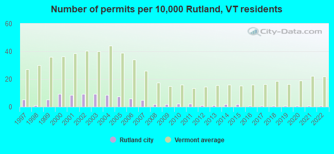
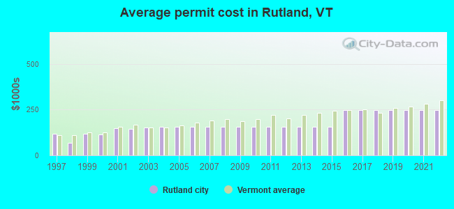
Single-family new house construction building permits:
- 2022: 1 building, cost: $246,000
- 2021: 1 building, cost: $246,000
- 2020: 1 building, cost: $246,000
- 2019: 1 building, cost: $246,000
- 2018: 1 building, cost: $246,000
- 2017: 1 building, cost: $246,000
- 2016: 1 building, cost: $246,000
- 2015: 3 buildings, average cost: $154,900
- 2014: 3 buildings, average cost: $154,900
- 2013: 2 buildings, average cost: $154,900
- 2012: 2 buildings, average cost: $154,900
- 2011: 4 buildings, average cost: $154,900
- 2010: 4 buildings, average cost: $154,900
- 2009: 3 buildings, average cost: $154,900
- 2008: 3 buildings, average cost: $154,900
- 2007: 8 buildings, average cost: $154,900
- 2006: 10 buildings, average cost: $154,900
- 2005: 13 buildings, average cost: $154,800
- 2004: 15 buildings, average cost: $155,300
- 2003: 16 buildings, average cost: $151,900
- 2002: 16 buildings, average cost: $145,200
- 2001: 15 buildings, average cost: $148,500
- 2000: 16 buildings, average cost: $115,200
- 1999: 9 buildings, average cost: $117,800
- 1998: 2 buildings, average cost: $67,500
- 1997: 9 buildings, average cost: $119,100
| Here: | 2.6% |
| Vermont: | 2.0% |
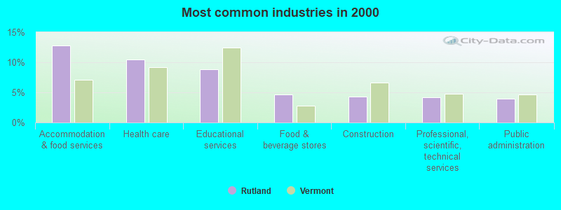
- Accommodation & food services (12.8%)
- Health care (10.5%)
- Educational services (8.8%)
- Food & beverage stores (4.7%)
- Construction (4.3%)
- Professional, scientific, technical services (4.2%)
- Public administration (3.9%)
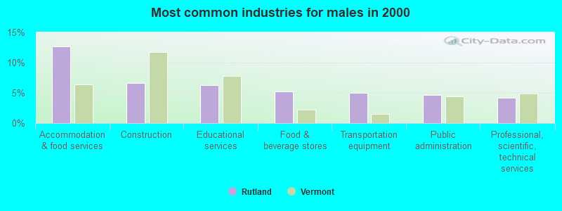
- Accommodation & food services (12.6%)
- Construction (6.7%)
- Educational services (6.3%)
- Food & beverage stores (5.2%)
- Transportation equipment (5.0%)
- Public administration (4.6%)
- Professional, scientific, technical services (4.2%)
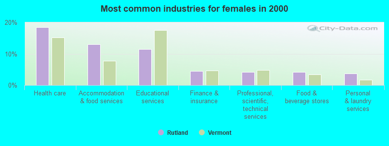
- Health care (18.4%)
- Accommodation & food services (13.1%)
- Educational services (11.5%)
- Finance & insurance (4.5%)
- Professional, scientific, technical services (4.2%)
- Food & beverage stores (4.2%)
- Personal & laundry services (3.7%)
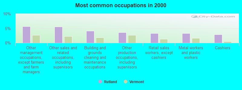
- Other management occupations, except farmers and farm managers (5.7%)
- Other sales and related occupations, including supervisors (5.5%)
- Building and grounds cleaning and maintenance occupations (4.1%)
- Other production occupations, including supervisors (3.6%)
- Retail sales workers, except cashiers (3.3%)
- Metal workers and plastic workers (3.3%)
- Cashiers (2.8%)
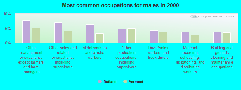
- Other management occupations, except farmers and farm managers (7.8%)
- Other sales and related occupations, including supervisors (7.0%)
- Metal workers and plastic workers (6.4%)
- Other production occupations, including supervisors (4.7%)
- Driver/sales workers and truck drivers (4.4%)
- Material recording, scheduling, dispatching, and distributing workers (3.8%)
- Building and grounds cleaning and maintenance occupations (3.7%)
- Secretaries and administrative assistants (5.4%)
- Other office and administrative support workers, including supervisors (4.6%)
- Building and grounds cleaning and maintenance occupations (4.6%)
- Retail sales workers, except cashiers (4.5%)
- Cashiers (4.1%)
- Other sales and related occupations, including supervisors (3.9%)
- Preschool, kindergarten, elementary, and middle school teachers (3.9%)
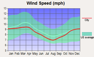
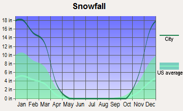
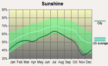
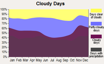
Average climate in Rutland, Vermont
Based on data reported by over 4,000 weather stations
|
|

(lower is better)

Air Quality Index (AQI) level in 2022 was 56.9. This is better than average.
| City: | 56.9 |
| U.S.: | 72.6 |
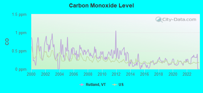
Carbon Monoxide (CO) [ppm] level in 2022 was 0.251. This is about average. Closest monitor was 0.4 miles away from the city center.
| City: | 0.251 |
| U.S.: | 0.251 |
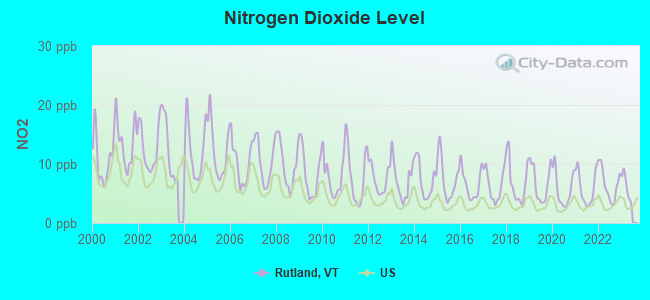
Nitrogen Dioxide (NO2) [ppb] level in 2022 was 6.51. This is worse than average. Closest monitor was 0.4 miles away from the city center.
| City: | 6.51 |
| U.S.: | 5.11 |
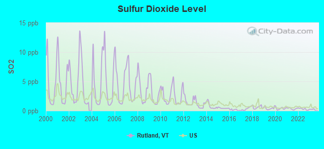
Sulfur Dioxide (SO2) [ppb] level in 2022 was 0.299. This is significantly better than average. Closest monitor was 0.3 miles away from the city center.
| City: | 0.299 |
| U.S.: | 1.515 |
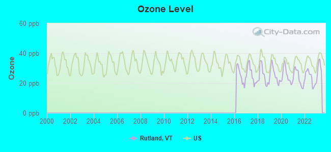
Ozone [ppb] level in 2022 was 23.5. This is significantly better than average. Closest monitor was 0.4 miles away from the city center.
| City: | 23.5 |
| U.S.: | 33.3 |
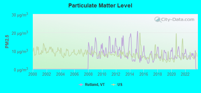
Particulate Matter (PM2.5) [µg/m3] level in 2022 was 7.23. This is about average. Closest monitor was 0.4 miles away from the city center.
| City: | 7.23 |
| U.S.: | 8.11 |
Tornado activity:
Rutland-area historical tornado activity is slightly above Vermont state average. It is 71% smaller than the overall U.S. average.
On 8/20/1968, a category F3 (max. wind speeds 158-206 mph) tornado 36.2 miles away from the Rutland city center injured one person and caused between $5000 and $50,000 in damages.
On 5/31/1998, a category F3 tornado 48.0 miles away from the city center injured 68 people and caused $71 million in damages.
Earthquake activity:
Rutland-area historical earthquake activity is significantly above Vermont state average. It is 69% smaller than the overall U.S. average.On 4/20/2002 at 10:50:47, a magnitude 5.3 (5.3 ML, Depth: 3.0 mi, Class: Moderate, Intensity: VI - VII) earthquake occurred 72.2 miles away from Rutland center
On 10/7/1983 at 10:18:46, a magnitude 5.3 (5.1 MB, 5.3 LG, 5.1 ML) earthquake occurred 72.4 miles away from Rutland center
On 4/20/2002 at 10:50:47, a magnitude 5.2 (5.2 MB, 4.2 MS, 5.2 MW, 5.0 MW) earthquake occurred 71.2 miles away from the city center
On 1/19/1982 at 00:14:42, a magnitude 4.7 (4.5 MB, 4.7 MD, 4.5 LG, Class: Light, Intensity: IV - V) earthquake occurred 69.3 miles away from the city center
On 10/16/2012 at 23:12:25, a magnitude 4.7 (4.7 ML, Depth: 10.0 mi) earthquake occurred 116.1 miles away from Rutland center
On 6/17/1991 at 08:53:16, a magnitude 4.1 (4.0 MB, 4.0 LG, Depth: 3.1 mi) earthquake occurred 109.4 miles away from the city center
Magnitude types: regional Lg-wave magnitude (LG), body-wave magnitude (MB), duration magnitude (MD), local magnitude (ML), surface-wave magnitude (MS), moment magnitude (MW)
Natural disasters:
The number of natural disasters in Rutland County (16) is near the US average (15).Major Disasters (Presidential) Declared: 11
Emergencies Declared: 2
Causes of natural disasters: Floods: 9, Storms: 9, Tropical Storms: 2, Winter Storms: 2, Hurricane: 1, Landslide: 1, Snowstorm: 1, Wind: 1, Other: 1 (Note: some incidents may be assigned to more than one category).
Main business address for: CASELLA WASTE SYSTEMS INC (REFUSE SYSTEMS), CENTRAL VERMONT PUBLIC SERVICE CORP (ELECTRIC SERVICES).
Hospitals and medical centers in Rutland:
- RUTLAND REGIONAL MEDICAL CENTER (Voluntary non-profit - Other, 160 ALLEN ST)
- WESTVIEW COURT (3 WESTVIEW COURT)
- MOUNTAIN VIEW CENTER GENESIS HEALTHCARE (9 HAYWOOD AVENUE)
- RUTLAND HEALTHCARE AND REHABILITATION CENTER (46 NICHOLS STREET)
- THE PINES AT RUTLAND CENTER FOR NURSING AND REHABI (99 ALLEN STREET)
- VERMONT ACHIEVEMENT CENTER (88 PARK ST)
- FLETCHER ALLEN HEALTHCARE - RRMC SATELLITE (160 ALLEN STREET)
- RUTLAND AREA VNA (7 ALBERT CREE)
Airports and heliports located in Rutland:
- Rutland - Southern Vermont Regional Airport (RUT) (Runways: 2, Air Taxi Ops: 7,100, Itinerant Ops: 10,670, Local Ops: 13,000, Military Ops: 1,000)
- Rutland Regional Medical Center Heliport (VT61)
- Velco Heliport (VT16)
Amtrak station:
RUTLAND (MERCHANTS ROW) . Services: ticket office, fully wheelchair accessible, enclosed waiting area, public restrooms, public payphones, vending machines, free short-term parking, free long-term parking, call for car rental service, call for taxi service, intercity bus service, public transit connection.College/University in Rutland:
Colleges/universities with over 2000 students nearest to Rutland:
- Castleton State College (about 11 miles; Castleton, VT; Full-time enrollment: 2,079)
- Middlebury College (about 30 miles; Middlebury, VT; FT enrollment: 3,077)
- Dartmouth College (about 35 miles; Hanover, NH; FT enrollment: 6,030)
- Adirondack Community College (about 39 miles; Queensbury, NY; FT enrollment: 2,826)
- Norwich University (about 40 miles; Northfield, VT; FT enrollment: 4,221)
- Skidmore College (about 55 miles; Saratoga Springs, NY; FT enrollment: 2,753)
- SUNY Empire State College (about 55 miles; Saratoga Springs, NY; FT enrollment: 9,473)
Public high school in Rutland:
- RUTLAND SENIOR HIGH SCHOOL (Students: 1,134, Location: 22 STRATTON ROAD, Grades: 9-12)
Private high schools in Rutland:
- MOUNT ST JOSEPH ACADEMY (Students: 95, Location: 127 CONVENT AVE, Grades: 9-12)
- RUTLAND AREA CHRISTIAN SCHOOL (Students: 62, Location: 112 LINCOLN AVE, Grades: PK-12)
- SHELDON ACADEMY OF VERMONT ACHIEVEMENT CENTER (Students: 18, Location: 88 PARK ST, Grades: 3-12)
- EASTER SEALS OF VERMONT (Students: 3, Location: 11 BURNHAM AVE, Grades: 10-11, Girls only)
Public elementary/middle schools in Rutland:
- RUTLAND INTERMEDIATE SCHOOL (Students: 708, Location: 63-65 LIBRARY AVENUE, Grades: 3-6)
- RUTLAND MIDDLE SCHOOL (Students: 384, Location: 67 LIBRARY AVENUE, Grades: 7-8)
- RUTLAND NORTHWEST SCHOOL (Students: 284, Location: 80 PIERPOINT AVENUE, Grades: PK-2)
- RUTLAND NORTHEAST PRIMARY SCHOOL (Students: 270, Location: 117 TEMPLE STREET, Grades: PK-2)
Private elementary/middle school in Rutland:
Points of interest:
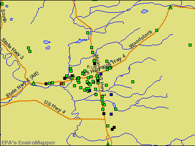
Notable locations in Rutland: Riverside Reformatory (A), Rutland City Swimming Pool (B), Rutland Country Club (C), Rutland Golf Course (D), Lawrence Recreation Center (E), College of Saint Joseph Playhouse (F), Chaffee Art Center (G), City of Rutland Fire Department (H), Vermont State Southwest Regional Library (I), Senior Citizens Center (J), Saint Joseph College Library (K), Rutland Regional Medical Center Health Science Library (L), Rutland Regional Chamber of Commerce (M), Rutland Historical Society Museum (N), Rutland Historical Society Building (O), Rutland Free Library (P), Rutland County Courthouse (Q), Rutland City Hall (R), Regional Ambulance Service (S). Display/hide their locations on the map
Shopping Center: Rutland Plaza Shopping Center (1). Display/hide its location on the map
Main business address in Rutland include: CASELLA WASTE SYSTEMS INC (A), CENTRAL VERMONT PUBLIC SERVICE CORP (B). Display/hide their locations on the map
Churches in Rutland include: Mount Saint Joseph Convent (A), First Methodist Church (B), Grace Congregational Church (C), Immaculater Heart of Mary Roman Catholic Church (D), Saint Joseph Novitiate (E), Messiah Lutheran Church (F), Rutland Jewish Center (G), Saint Josephs Convent (H), Saint Pauls Universalist Church (I). Display/hide their locations on the map
Cemeteries: Old West Street Cemetery (1), North Main Cemetery (2), Evergreen Cemetery (3), Saint Josephs Cemetery (4), Calvary Cemetery (5), West Street Cemetery (6). Display/hide their locations on the map
Lakes and reservoirs: Dunklee Pond (A), Piedmont Pond (B), Patch Pond (C), Rocky Pond (D), Muddy Pond (E), Lower Eddy Pond (F), Combination Pond (G). Display/hide their locations on the map
Streams, rivers, and creeks: Tenney Brook (A), Mussey Brook (B), Moon Brook (C), East Creek (D). Display/hide their locations on the map
Parks in Rutland include: Pine Hill Park (1), Main Street Park (2), Whites Playground (3), Rutland Downtown Historic District (4), Rutland Courthouse Historic District (5). Display/hide their locations on the map
Tourist attractions: Wilson Castle (Museums; West Proctor Road), Rutland Historical Society (Museums; 96 Center Street), Norman Rockwell Museum (Woodstock Avenue), Prints N 'things (Museums; Woodstock Avenue), Rutland Music Service Incorporated (Amusement & Theme Parks; 11 Terrill Street), Virtual Vermont Internet Magazine (16 Laverne Drive), Rutland Region Chamber of Commerce (256 North Main Street), Private Driver Service (189 North Main Street), High Voltage Audio (Arcades & Amusements; 129 Maple Street).
Hotels: Nordic Inn (Woodstock Avenue), Highlander Motel (203 North Main Street), Holiday Inn Rutland/Killington Area- Vt (476 Us Route 7 S), Ramada Limited Of Rutland (253 S Main St), Val Roc Motel (Route 4), Econo Lodge Killington Area (51 Route 4), Best Western Inn-Stes Rutland (1 US Route 4), Rutland Motel (125 Woodstock Avenue), Royal Motel (115 Woodstock Avenue).
Courts: Rutland Court Division Programs Inc (50 Center Street), United States Government - Courts- District Court- Probation Office (151 West Street), United States Government - Courts- Bankruptcy Court- Clerk's Office (67 Merchants Row), Vermont State - Courts- Family Court- Rutland Family (83 Center Street), Superior Court Rutland (83 Center Street), United States Government - Courts- District Court- Judge's Chambers (151 West Street), United States Government - District Court- Courts- Clerk's Office (151 West Street).
Birthplace of: Harry Hulihan - Major League Baseball pitcher, Harvey H. Johnson - Politician, James Patrick Leamy - Federal judge.
Drinking water stations with addresses in Rutland and their reported violations in the past:
RUTLAND CITY WATER DEPT (Population served: 18,500, Surface water):Past health violations:KILLINGTON HIGH RIDGE CONDOMINIUM (Population served: 500, Groundwater):
- MCL, Average - Between JAN-2012 and MAR-2012, Contaminant: Total Haloacetic Acids (HAA5). Follow-up actions: St Public Notif requested (MAY-24-2012), St Formal NOV issued (MAY-24-2012), St Tech Assistance Visit (MAY-24-2012), St Public Notif received (JUN-15-2012), St AO (w/o penalty) issued (MAR-15-2013), St Compliance achieved (MAY-17-2013)
- MCL, Average - Between OCT-2011 and DEC-2011, Contaminant: Total Haloacetic Acids (HAA5). Follow-up actions: St Public Notif requested (MAR-15-2012), St Formal NOV issued (MAR-15-2012), St Tech Assistance Visit (MAR-15-2012), St Public Notif received (APR-11-2012), St AO (w/o penalty) issued (MAR-15-2013), St Compliance achieved (MAY-17-2013)
- MCL, Average - Between JUL-2011 and SEP-2011, Contaminant: Total Haloacetic Acids (HAA5). Follow-up actions: St Public Notif requested (JAN-27-2012), St Formal NOV issued (JAN-27-2012), St Tech Assistance Visit (JAN-27-2012), St AO (w/o penalty) issued (FEB-02-2012), St Public Notif received (FEB-21-2012), St Compliance achieved (MAY-17-2013)
- MCL, Average - Between APR-2011 and JUN-2011, Contaminant: Total Haloacetic Acids (HAA5). Follow-up actions: St Public Notif requested (JUL-27-2011), St Formal NOV issued (JUL-27-2011), St Tech Assistance Visit (JUL-27-2011), St Public Notif received (AUG-22-2011), St AO (w/o penalty) issued (FEB-02-2012), St Compliance achieved (MAY-17-2013)
- MCL, Average - Between JAN-2011 and MAR-2011, Contaminant: Total Haloacetic Acids (HAA5). Follow-up actions: St Public Notif requested (APR-29-2011), St Formal NOV issued (APR-29-2011), St Tech Assistance Visit (APR-29-2011), St Public Notif received (MAY-12-2011), St AO (w/o penalty) issued (FEB-02-2012), St Compliance achieved (MAY-17-2013)
- MCL, Average - Between OCT-2010 and DEC-2010, Contaminant: Total Haloacetic Acids (HAA5). Follow-up actions: St Public Notif requested (JAN-25-2011), St Formal NOV issued (JAN-25-2011), St Tech Assistance Visit (JAN-25-2011), St Public Notif received (FEB-17-2011), St AO (w/o penalty) issued (FEB-02-2012), St Compliance achieved (MAY-17-2013)
- 15 other older health violations
Past monitoring violations:EMERALD LAKE STATE PARK (Address: 271 N MAIN ST SUITE 215 , Population served: 420, Groundwater):
- One routine major monitoring violation
Past monitoring violations:RUTLAND AIRPORT BUSINESS PARK ASSO. (Address: 204 S MAIN ST , Population served: 280, Groundwater):
- One minor monitoring violation
Past monitoring violations:CLEAR RIVER INN TAVERN (Address: 199 STRATTON RD , Population served: 262, Groundwater):
- 2 routine major monitoring violations
Past monitoring violations:HALF MOON STATE PARK (Address: 271 N MAIN ST SUITE 215 , Population served: 250, Groundwater):
- 7 routine major monitoring violations
- One minor monitoring violation
- 2 regular monitoring violations
Past monitoring violations:MOUNT PHILO STATE PARK (Address: 271 N MAIN ST SUITE 215 , Population served: 200, Groundwater):
- 3 routine major monitoring violations
Past health violations:COLONIAL ESTATES WATER CORP (Address: 95 GEORGEANNA BLVD , Population served: 200, Groundwater):Past monitoring violations:
- MCL, Monthly (TCR) - Between APR-2006 and JUN-2006, Contaminant: Coliform. Follow-up actions: St Tech Assistance Visit (JUN-21-2006), St Boil Water Order (JUN-21-2006), St Public Notif requested (JUN-21-2006), St Formal NOV issued (JUN-21-2006), St Compliance achieved (JAN-29-2007)
- One minor monitoring violation
Past health violations:Past monitoring violations:
- MCL, Monthly (TCR) - In AUG-2013, Contaminant: Coliform. Follow-up actions: St Tech Assistance Visit (SEP-03-2013), St Formal NOV issued (SEP-03-2013), St Public Notif requested (SEP-03-2013), St Boil Water Order (SEP-03-2013), St Compliance achieved (SEP-10-2013)
- Initial, Follow-up, or Routine Source Water M/R - In JAN-01-2002, Contaminant: Lead and Copper Rule
- Follow-up Or Routine LCR Tap M/R - In JAN-01-1999, Contaminant: Lead and Copper Rule
- Follow-up Or Routine LCR Tap M/R - In JAN-01-1999, Contaminant: Lead and Copper Rule. Follow-up actions: St Public Notif requested (JUL-01-1999), St Violation/Reminder Notice (JUL-01-1999), St Public Notif received (MAY-10-2001), St Compliance achieved (APR-26-2011)
- One routine major monitoring violation
- 22 regular monitoring violations
Drinking water stations with addresses in Rutland that have no violations reported:
- WOODFORD STATE PARK (Address: 271 N MAIN ST SUITE 215 , Population served: 419, Primary Water Source Type: Groundwater)
- BOMOSEEN STATE PARK (Address: 271 N MAIN ST SUITE 215 , Population served: 225, Primary Water Source Type: Groundwater)
- LAKE ST CATHERINE STATE PARK (Address: 271 N MAIN ST SUITE 215 , Population served: 196, Primary Water Source Type: Groundwater)
- VERMONT ELECTRIC POWER CO (Address: 366 PINNACLE RIDGE RD , Population served: 150, Primary Water Source Type: Groundwater)
- GMP - SYSTEMS OPERATIONS (Address: 2152 POST ROAD , Population served: 70, Primary Water Source Type: Groundwater)
- GMP - RUTLAND DISTRICT (Address: 2152 POST ROAD , Population served: 50, Primary Water Source Type: Groundwater)
- EXIT 23 TRUCK STOP (Serves NY, Population served: 25, Primary Water Source Type: Groundwater)
| This city: | 2.1 people |
| Vermont: | 2.3 people |
| This city: | 52.8% |
| Whole state: | 62.5% |
| This city: | 9.3% |
| Whole state: | 9.2% |
Likely homosexual households (counted as self-reported same-sex unmarried-partner households)
- Lesbian couples: 0.5% of all households
- Gay men: 0.2% of all households
People in group quarters in Rutland in 2010:
- 312 people in nursing facilities/skilled-nursing facilities
- 145 people in state prisons
- 68 people in emergency and transitional shelters (with sleeping facilities) for people experiencing homelessness
- 64 people in college/university student housing
- 27 people in group homes intended for adults
- 27 people in residential treatment centers for adults
- 9 people in residential treatment centers for juveniles (non-correctional)
- 9 people in other noninstitutional facilities
People in group quarters in Rutland in 2000:
- 434 people in nursing homes
- 117 people in state prisons
- 83 people in college dormitories (includes college quarters off campus)
- 76 people in other noninstitutional group quarters
- 9 people in homes or halfway houses for drug/alcohol abuse
Banks with branches in Rutland (2011 data):
- TD Bank, National Association: Rutland Plaza Branch, Rutland Branch, South Rutland Branch, Killington Branch. Info updated 2010/10/04: Bank assets: $188,912.6 mil, Deposits: $153,149.8 mil, headquarters in Wilmington, DE, positive income, 1314 total offices, Holding Company: Toronto-Dominion Bank, The
- RBS Citizens, National Association: Rutland Shopping Plaza / Price Chopp, Rutland, Rutland Drive Thru Branch. Info updated 2007/09/19: Bank assets: $106,940.6 mil, Deposits: $75,690.2 mil, headquarters in Providence, RI, positive income, 1135 total offices, Holding Company: Uk Financial Investments Limited
- Lake Sunapee Bank, FSB: Rutland Merchants Row Branch at 104 Merchants Row, branch established on 2003/02/24; Rutland Woodstock Ave Branch at 100 Woodstock Avenue, branch established on 2006/06/12. Info updated 2011/07/21: Bank assets: $1,040.6 mil, Deposits: $808.6 mil, headquarters in Newport, NH, positive income, Mortgage Lending Specialization, 27 total offices
- Merchants Bank: Rutland-Green Mtn Plaza Br at 286 Route 7, South, branch established on 1996/06/30; Woodstock Avenue Branch at 92 Woodstock Avenue, branch established on 1999/11/01. Info updated 2011/12/09: Bank assets: $1,615.1 mil, Deposits: $1,179.4 mil, headquarters in Burlington, VT, positive income, Commercial Lending Specialization, 34 total offices, Holding Company: Merchants Bancshares, Inc.
- Berkshire Bank: Court Square Branch at 22 West Street, branch established on 1995/07/10; Rutland-Woodstock Ave Br at 143 Woodstock Avenue, branch established on 1936/03/13. Info updated 2011/08/24: Bank assets: $3,955.6 mil, Deposits: $3,176.2 mil, headquarters in Pittsfield, MA, positive income, Commercial Lending Specialization, 64 total offices
- People's United Bank: West Street Branch at 87 West Street, branch established on 1986/04/26; Woodstock Avenue Branch at 77 Woodstock Avenue, branch established on 1978/05/22. Info updated 2012/02/16: Bank assets: $27,319.3 mil, Deposits: $20,835.4 mil, headquarters in Bridgeport, CT, positive income, Commercial Lending Specialization, 374 total offices
- KeyBank National Association: Rutland Branch at 80 West Street, branch established on 1988/01/20. Info updated 2008/03/03: Bank assets: $86,198.8 mil, Deposits: $64,214.8 mil, headquarters in Cleveland, OH, positive income, Commercial Lending Specialization, 1067 total offices, Holding Company: Keycorp
For population 15 years and over in Rutland:
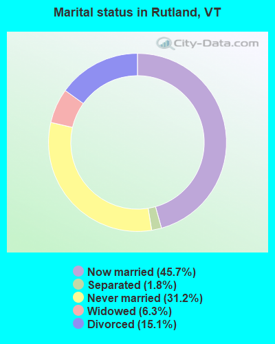
- Never married: 31.2%
- Now married: 45.7%
- Separated: 1.8%
- Widowed: 6.3%
- Divorced: 15.1%
For population 25 years and over in Rutland:
- High school or higher: 91.7%
- Bachelor's degree or higher: 32.1%
- Graduate or professional degree: 13.1%
- Unemployed: 5.2%
- Mean travel time to work (commute): 13.9 minutes
| Here: | 10.9 |
| Vermont average: | 10.8 |
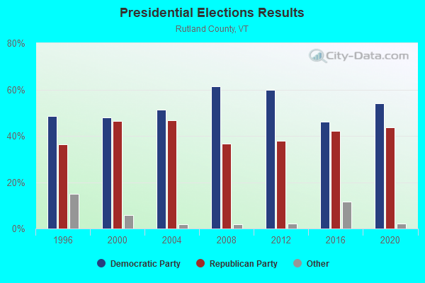
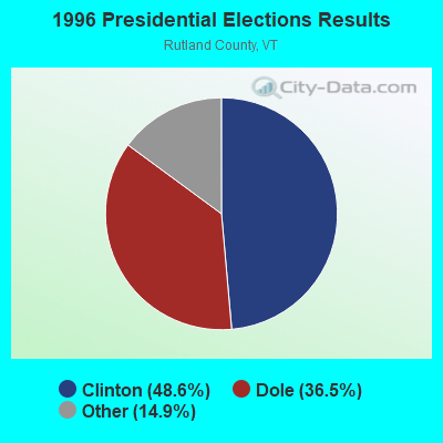
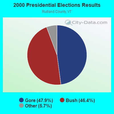
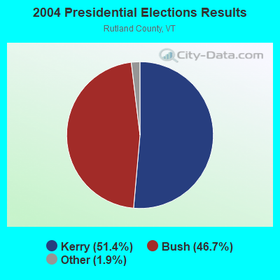
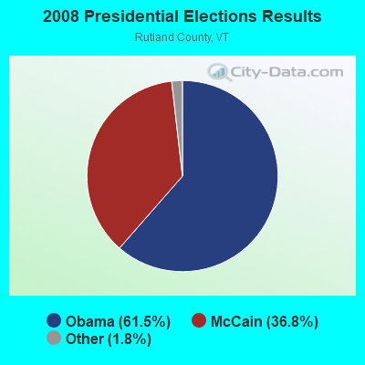
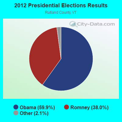
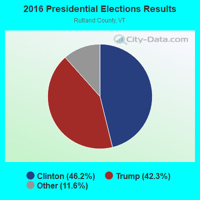
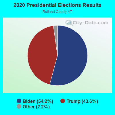
Graphs represent county-level data. Detailed 2008 Election Results
Religion statistics for Rutland, VT (based on Rutland County data)

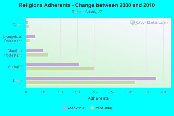
| Religion | Adherents | Congregations |
|---|---|---|
| Catholic | 15,500 | 17 |
| Mainline Protestant | 4,944 | 38 |
| Evangelical Protestant | 2,587 | 36 |
| Other | 520 | 5 |
| Orthodox | 85 | 1 |
| None | 38,006 | - |
Food Environment Statistics:
| Here: | 3.78 / 10,000 pop. |
| Vermont: | 3.84 / 10,000 pop. |
| Rutland County: | 2.05 / 10,000 pop. |
| Vermont: | 1.95 / 10,000 pop. |
| Rutland County: | 7.56 / 10,000 pop. |
| Vermont: | 6.40 / 10,000 pop. |
| This county: | 12.77 / 10,000 pop. |
| State: | 11.52 / 10,000 pop. |
| Here: | 7.8% |
| Vermont: | 6.8% |
| Rutland County: | 24.1% |
| Vermont: | 22.3% |
| This county: | 18.5% |
| State: | 13.3% |
Health and Nutrition:
| Rutland: | 51.8% |
| Vermont: | 52.9% |
| This city: | 49.7% |
| Vermont: | 51.9% |
| Rutland: | 28.7 |
| Vermont: | 28.4 |
| This city: | 21.8% |
| State: | 21.2% |
| Here: | 10.6% |
| Vermont: | 8.8% |
| Rutland: | 6.9 |
| Vermont: | 6.9 |
| Rutland: | 34.1% |
| Vermont: | 34.9% |
| Rutland: | 57.4% |
| Vermont: | 59.7% |
| Rutland: | 77.8% |
| State: | 79.6% |
More about Health and Nutrition of Rutland, VT Residents
| Local government employment and payroll (March 2022) | |||||
| Function | Full-time employees | Monthly full-time payroll | Average yearly full-time wage | Part-time employees | Monthly part-time payroll |
|---|---|---|---|---|---|
| Police Protection - Officers | 36 | $246,730 | $82,243 | 1 | $4,020 |
| Firefighters | 28 | $171,388 | $73,452 | 0 | $0 |
| Other Government Administration | 21 | $130,270 | $74,440 | 0 | $0 |
| Streets and Highways | 15 | $82,732 | $66,186 | 0 | $0 |
| Water Supply | 14 | $72,948 | $62,527 | 0 | $0 |
| Parks and Recreation | 11 | $59,704 | $65,132 | 21 | $17,347 |
| Sewerage | 11 | $70,007 | $76,371 | 0 | $0 |
| Financial Administration | 6 | $30,525 | $61,050 | 1 | $1,455 |
| Judicial and Legal | 1 | $8,912 | $106,944 | 1 | $3,288 |
| Police - Other | 1 | $5,849 | $70,188 | 0 | $0 |
| Totals for Government | 144 | $879,064 | $73,255 | 24 | $26,110 |
Rutland government finances - Expenditure in 2021 (per resident):
- Construction - Sewerage: $956,000 ($60.91)
Water Utilities: $956,000 ($60.91)
Regular Highways: $143,000 ($9.11)
- Current Operations - Police Protection: $6,336,000 ($403.70)
Sewerage: $5,235,000 ($333.55)
Regular Highways: $4,526,000 ($288.37)
Local Fire Protection: $3,777,000 ($240.65)
Water Utilities: $2,372,000 ($151.13)
Parks and Recreation: $2,243,000 ($142.91)
General - Other: $1,454,000 ($92.64)
Housing and Community Development: $887,000 ($56.51)
Financial Administration: $830,000 ($52.88)
Libraries: $772,000 ($49.19)
Central Staff Services: $731,000 ($46.58)
Protective Inspection and Regulation - Other: $457,000 ($29.12)
General Public Buildings: $323,000 ($20.58)
Judicial and Legal Services: $300,000 ($19.11)
Parking Facilities: $257,000 ($16.37)
Transit Utilities: $248,000 ($15.80)
- General - Interest on Debt: $139,000 ($8.86)
- Other Capital Outlay - Local Fire Protection: $1,545,000 ($98.44)
Regular Highways: $771,000 ($49.12)
Water Utilities: $620,000 ($39.50)
Housing and Community Development: $150,000 ($9.56)
Parks and Recreation: $104,000 ($6.63)
Police Protection: $76,000 ($4.84)
Sewerage: $53,000 ($3.38)
General - Other: $28,000 ($1.78)
- Water Utilities - Interest on Debt: $64,000 ($4.08)
Rutland government finances - Revenue in 2021 (per resident):
- Charges - Sewerage: $5,191,000 ($330.74)
Other: $1,813,000 ($115.51)
Parks and Recreation: $497,000 ($31.67)
Housing and Community Development: $190,000 ($12.11)
Parking Facilities: $143,000 ($9.11)
Regular Highways: $20,000 ($1.27)
- Federal Intergovernmental - Other: $133,000 ($8.47)
- Local Intergovernmental - Highways: $1,000 ($0.06)
- Miscellaneous - General Revenue - Other: $262,000 ($16.69)
Interest Earnings: $96,000 ($6.12)
Donations From Private Sources: $93,000 ($5.93)
Fines and Forfeits: $8,000 ($0.51)
Sale of Property: $3,000 ($0.19)
- Revenue - Water Utilities: $3,479,000 ($221.66)
Transit Utilities: $252,000 ($16.06)
- State Intergovernmental - General Local Government Support: $966,000 ($61.55)
Highways: $347,000 ($22.11)
Other: $190,000 ($12.11)
Housing and Community Development: $188,000 ($11.98)
- Tax - Property: $19,191,000 ($1222.75)
Other Selective Sales: $542,000 ($34.53)
Other License: $408,000 ($26.00)
Rutland government finances - Debt in 2021 (per resident):
- Long Term Debt - Beginning Outstanding - Unspecified Public Purpose: $13,025,000 ($829.88)
Outstanding Unspecified Public Purpose: $10,687,000 ($680.92)
Retired Unspecified Public Purpose: $2,338,000 ($148.96)
Rutland government finances - Cash and Securities in 2021 (per resident):
- Bond Funds - Cash and Securities: $851,000 ($54.22)
- Other Funds - Cash and Securities: $10,072,000 ($641.73)
| Businesses in Rutland, VT | ||||
| Name | Count | Name | Count | |
|---|---|---|---|---|
| AT&T | 2 | Little Caesars Pizza | 1 | |
| Ace Hardware | 1 | MasterBrand Cabinets | 7 | |
| Advance Auto Parts | 1 | Maurices | 1 | |
| American Eagle Outfitters | 1 | McDonald's | 2 | |
| Applebee's | 1 | New Balance | 3 | |
| Audi | 1 | Nike | 6 | |
| Bath & Body Works | 1 | Nissan | 1 | |
| Bed Bath & Beyond | 1 | Old Navy | 1 | |
| Ben & Jerry's | 1 | Pac Sun | 1 | |
| Best Western | 1 | Payless | 1 | |
| Blockbuster | 1 | Penske | 1 | |
| Burger King | 1 | Pizza Hut | 1 | |
| CVS | 1 | Quiznos | 1 | |
| Chevrolet | 1 | Ramada | 1 | |
| Circle K | 1 | Red Roof Inn | 1 | |
| Comfort Inn | 1 | Rite Aid | 1 | |
| Curves | 1 | Rodeway Inn | 2 | |
| Decora Cabinetry | 2 | Sears | 2 | |
| Dennys | 1 | Sprint Nextel | 2 | |
| Domino's Pizza | 1 | Staples | 1 | |
| Dunkin Donuts | 4 | Subaru | 1 | |
| FedEx | 3 | Subway | 2 | |
| Ford | 1 | T.J.Maxx | 1 | |
| GNC | 1 | Taco Bell | 1 | |
| GameStop | 2 | Toyota | 1 | |
| H&R Block | 1 | True Value | 1 | |
| Hilton | 1 | U-Haul | 1 | |
| Holiday Inn | 1 | UPS | 5 | |
| Home Depot | 1 | Vans | 2 | |
| Honda | 1 | Verizon Wireless | 2 | |
| JCPenney | 1 | Victoria's Secret | 1 | |
| KFC | 1 | Volkswagen | 1 | |
| Kincaid | 1 | Walgreens | 1 | |
| La-Z-Boy | 1 | Walmart | 1 | |
| Lane Furniture | 2 | Wendy's | 1 | |
Strongest AM radio stations in Rutland:
- WSYB (1380 AM; 5 kW; RUTLAND, VT; Owner: CAPSTAR TX LIMITED PARTNERSHIP)
- WGY (810 AM; 50 kW; SCHENECTADY, NY; Owner: CLEAR CHANNEL BROADCASTING LICENSES, INC.)
- WNNZ (640 AM; 50 kW; WESTFIELD, MA; Owner: CLEAR CHANNEL BROADCASTING LICENSES, INC.)
- WPTR (1540 AM; 50 kW; ALBANY, NY; Owner: KIMTRON, INC.)
- WNTK (1020 AM; 10 kW; NEWPORT, NH; Owner: KOOR COMMUNICATIONS, INC.)
- WRKO (680 AM; 50 kW; BOSTON, MA; Owner: ENTERCOM BOSTON LICENSE, LLC)
- WCRN (830 AM; 50 kW; WORCESTER, MA; Owner: CARTER BROADCASTING CORPORATION)
- WCHP (760 AM; 35 kW; CHAMPLAIN, NY; Owner: CHAMPLAIN RADIO, INC.)
- WVNR (1340 AM; 1 kW; POULTNEY, VT; Owner: PINE TREE BROADCASTING COMPANY)
- WEEI (850 AM; 50 kW; BOSTON, MA; Owner: ENTERCOM BOSTON LICENSE, LLC)
- WNBX (1480 AM; 5 kW; SPRINGFIELD, VT)
- WDEV (550 AM; 5 kW; WATERBURY, VT; Owner: RADIO VERMONT, INC.)
- WICY (1490 AM; 50 kW; MALONE, NY; Owner: CARTIER COMMUNICATIONS INC.)
Strongest FM radio stations in Rutland:
- WEBK (105.3 FM; KILLINGTON, VT; Owner: 6 JOHNSON ROAD LICENSES, INC.)
- WJJR (98.1 FM; RUTLAND, VT; Owner: 6 JOHNSON ROAD LICENSES, INC.)
- WZRT (97.1 FM; RUTLAND, VT; Owner: CAPSTAR TX LIMITED PARTNERSHIP)
- WGLV (91.7 FM; WOODSTOCK, VT; Owner: CHRISTIAN MINISTRIES INC)
- WHDQ-FM1 (106.1 FM; RUTLAND, VT; Owner: GREAT NORTHERN RADIO, L.L.C.)
- WJEN (94.5 FM; RUTLAND, VT; Owner: 6 JOHNSON ROAD LICENSES, INC.)
- WEXP (101.5 FM; BRANDON, VT; Owner: VOX VERMONT, L.L.C.)
- WFTF (90.5 FM; RUTLAND, VT; Owner: CHRISTIAN RADIO FELLOWSHIP)
- WEQX (102.7 FM; MANCHESTER, VT; Owner: NORTHSHIRE COMMUNICATIONS, INC.)
- WVPR (89.5 FM; WINDSOR, VT; Owner: VERMONT PUBLIC RADIO)
- WJAN (95.1 FM; SUNDERLAND, VT; Owner: 6 JOHNSON ROAD LICENSES, INC.)
- WDEV-FM (96.1 FM; WARREN, VT; Owner: RADIO VERMONT, INC.)
- WHDQ (106.1 FM; CLAREMONT, NH; Owner: GREAT NORTHERN RADIO, L.L.C.)
- WCVT (101.7 FM; STOWE, VT; Owner: RADIO VERMONT CLASSICS, L.L.C.)
- WVPS (107.9 FM; BURLINGTON, VT; Owner: VERMONT PUBLIC RADIO)
- WEZF (92.9 FM; BURLINGTON, VT; Owner: CAPSTAR TX LIMITED PARTNERSHIP)
- WLKC (103.3 FM; WATERBURY, VT; Owner: RADIO BROADCASTING SERVICES, INC.)
- WNGN (91.9 FM; ARGYLE, NY; Owner: NORTHEAST GOSPEL BROADCASTING INC)
- WMXR (93.9 FM; WOODSTOCK, VT; Owner: CLEAR CHANNEL BROADCASTING LICENSES, INC.)
- WXLG (89.9 FM; NORTH CREEK, NY; Owner: THE ST. LAWRENCE UNIVERSITY)
TV broadcast stations around Rutland:
- W07AG (Channel 7; RUTLAND, VT; Owner: WNYT INC.)
- W69AR (Channel 69; RUTLAND, VT; Owner: MT. MANSFIELD TELEVISION, INC.)
- WVER (Channel 28; RUTLAND, VT; Owner: VERMONT ETV, INC.)
- W61CE (Channel 61; RUTLAND, VT; Owner: MARGARET SANGUINETTI (ADMINISTRATRIX OF THE ESTATE))
- W18AE (Channel 18; KILLINGTON, VT; Owner: KILLINGTON, LTD.)
- W63AD (Channel 63; RUTLAND, VT; Owner: C-22 FCC LICENSEE SUBSIDIARY, LLC)
Medal of Honor Recipients
Medal of Honor Recipients born in Rutland: Merritt Austin Edson, Michael McCormlCk.
- National Bridge Inventory (NBI) Statistics
- 20Number of bridges
- 312ft / 94.9mTotal length
- $6,518,000Total costs
- 134,675Total average daily traffic
- 11,132Total average daily truck traffic
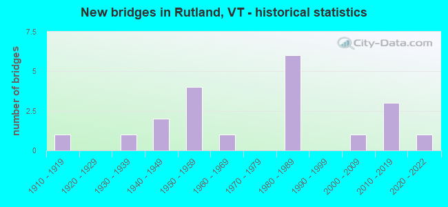
- New bridges - historical statistics
- 11910-1919
- 11930-1939
- 21940-1949
- 41950-1959
- 11960-1969
- 61980-1989
- 12000-2009
- 32010-2019
- 12020-2022
FCC Registered Commercial Land Mobile Towers: 3 (See the full list of FCC Registered Commercial Land Mobile Towers in Rutland, VT)
FCC Registered Private Land Mobile Towers: 1 (See the full list of FCC Registered Private Land Mobile Towers)
FCC Registered Broadcast Land Mobile Towers: 34 (See the full list of FCC Registered Broadcast Land Mobile Towers)
FCC Registered Microwave Towers: 31 (See the full list of FCC Registered Microwave Towers in this town)
FCC Registered Paging Towers: 7 (See the full list of FCC Registered Paging Towers)
FCC Registered Maritime Coast & Aviation Ground Towers: 5 (See the full list of FCC Registered Maritime Coast & Aviation Ground Towers)
FCC Registered Amateur Radio Licenses: 131 (See the full list of FCC Registered Amateur Radio Licenses in Rutland)
FAA Registered Aircraft: 32 (See the full list of FAA Registered Aircraft in Rutland)
2002 - 2018 National Fire Incident Reporting System (NFIRS) incidents
- Fire incident types reported to NFIRS in Rutland, VT
- 1,14263.2%Structure Fires
- 45425.1%Outside Fires
- 1377.6%Mobile Property/Vehicle Fires
- 754.1%Other
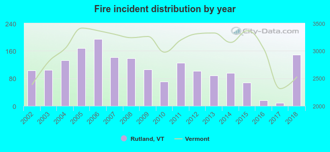 Based on the data from the years 2002 - 2018 the average number of fire incidents per year is 106. The highest number of fire incidents - 194 took place in 2006, and the least - 9 in 2017. The data has a growing trend.
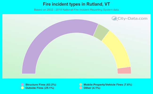 When looking into fire subcategories, the most incidents belonged to: Structure Fires (63.2%), and Outside Fires (25.1%).
Fire-safe hotels and motels in Rutland, Vermont:
- Holiday Inn Rutland/Killington, 476 Us Rt 7 S, Rutland, Vermont 05751 , Phone: (802) 775-1911, Fax: (802) 786-2124
- Red Roof Inn Of Vermont, 401 Us Rt 7 N, Rutland, Vermont 05701 , Phone: (802) 775-4303
- Econo Lodge, 238 S Main St, Rutland, Vermont 05701 , Phone: (802) 773-2784, Fax: (802) 773-2787
- Quality Inn Rutland, 253 S Main St, Rutland, Vermont 05701 , Phone: (802) 773-3361, Fax: (802) 773-4892
- Best Western Inn & Suites, One Rt 4 E, Rutland, Vermont 05701 , Phone: (802) 773-3200, Fax: (802) 773-6615
- Hampton Inn - Rutland/Killington, 47 Farrell Rd, Rutland, Vermont 05701 , Phone: (802) 773-9066, Fax: (419) 773-9077
| Most common first names in Rutland, VT among deceased individuals | ||
| Name | Count | Lived (average) |
|---|---|---|
| Mary | 363 | 81.7 years |
| John | 275 | 72.3 years |
| William | 173 | 74.4 years |
| Robert | 169 | 72.1 years |
| Charles | 131 | 76.6 years |
| James | 122 | 72.6 years |
| Edward | 121 | 74.0 years |
| George | 119 | 76.0 years |
| Margaret | 113 | 81.1 years |
| Richard | 111 | 71.3 years |
| Most common last names in Rutland, VT among deceased individuals | ||
| Last name | Count | Lived (average) |
|---|---|---|
| Smith | 60 | 80.3 years |
| Brown | 57 | 76.0 years |
| Johnson | 54 | 75.2 years |
| Ryan | 40 | 78.9 years |
| Burke | 38 | 76.3 years |
| White | 33 | 77.7 years |
| Fredette | 32 | 70.7 years |
| Perkins | 32 | 82.5 years |
| Taylor | 31 | 75.3 years |
| Davis | 29 | 75.1 years |
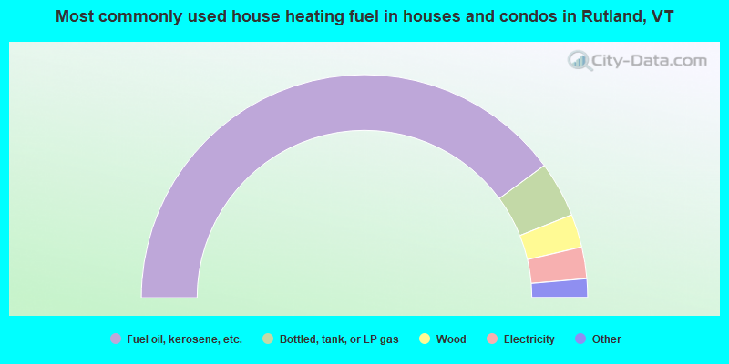
- 79.9%Fuel oil, kerosene, etc.
- 8.1%Bottled, tank, or LP gas
- 4.8%Wood
- 4.6%Electricity
- 1.7%Utility gas
- 1.0%Other fuel
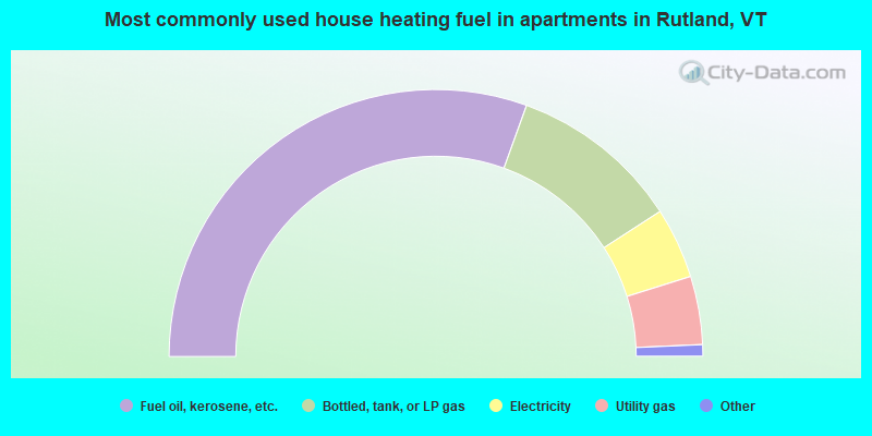
- 61.1%Fuel oil, kerosene, etc.
- 20.7%Bottled, tank, or LP gas
- 8.6%Electricity
- 8.3%Utility gas
- 1.1%Other fuel
- 0.3%Wood
Rutland compared to Vermont state average:
- Median house value below state average.
- Unemployed percentage below state average.
- Black race population percentage below state average.
- Foreign-born population percentage below state average.
- Renting percentage above state average.
- Length of stay since moving in significantly above state average.
- House age above state average.
- Institutionalized population percentage above state average.
Rutland on our top lists:
- #1 on the list of "Top 101 cities with the largest city-data.com crime index per police officer (population 5,000+)"
- #6 on the list of "Top 101 cities with the lowest number of police officers per 1000 residents (population 5,000+)"
- #12 on the list of "Top 101 counties with the highest percentage of residents that smoked 100+ cigarettes in their lives"
- #14 on the list of "Top 101 counties with the highest percentage of residents that keep firearms around their homes"
- #55 on the list of "Top 101 counties with the lowest average weight of females"
- #57 on the list of "Top 101 counties with the highest Sulfur Oxides Annual air pollution readings in 2012 (µg/m3)"
- #58 on the list of "Top 101 counties with the largest increase in the number of deaths per 1000 residents 2000-2006 to 2007-2013 (pop. 50,000+)"

|
|
Total of 73 patent applications in 2008-2024.