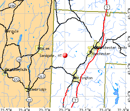
Sandgate, Vermont
Submit your own pictures of this town and show them to the world
- OSM Map
- General Map
- Google Map
- MSN Map
Population change since 2000: +14.7%
 |
| Males: 201 | |
| Females: 204 |
| Median resident age: | 46.4 years |
| Vermont median age: | 45.8 years |
Zip codes: 05250.
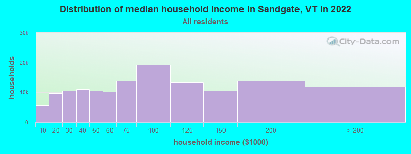
| Sandgate: | $70,809 |
| VT: | $73,991 |
Estimated per capita income in 2022: $41,977 (it was $22,096 in 2000)
Sandgate town income, earnings, and wages data
Estimated median house or condo value in 2022: $273,013 (it was $113,800 in 2000)
| Sandgate: | $273,013 |
| VT: | $304,700 |
Mean prices in 2022: all housing units: $328,619; detached houses: $344,818; townhouses or other attached units: $277,995; in 2-unit structures: $228,670; in 3-to-4-unit structures: $413,467; in 5-or-more-unit structures: $239,659; mobile homes: $88,728
Detailed information about poverty and poor residents in Sandgate, VT


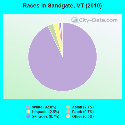
- 37692.8%White alone
- 112.7%Asian alone
- 102.5%Hispanic
- 30.7%Black alone
- 30.7%Two or more races
- 20.5%Other race alone
Races in Sandgate detailed stats: ancestries, foreign born residents, place of birth
According to our research of Vermont and other state lists, there was 1 registered sex offender living in Sandgate, Vermont as of May 14, 2024.
The ratio of all residents to sex offenders in Sandgate is 405 to 1.
The ratio of registered sex offenders to all residents in this city is near the state average.
 Recent articles from our blog. Our writers, many of them Ph.D. graduates or candidates, create easy-to-read articles on a wide variety of topics.

 | Stowe vs Manchester......Schools and quality of life? (10 replies) |
| High Schools in Vermont (23 replies) |
| Need some serious insight on old well and cesspool (1 reply) |
Latest news from Sandgate, VT collected exclusively by city-data.com from local newspapers, TV, and radio stations
Ancestries: German (19.5%), English (17.0%), Italian (15.6%), Irish (13.0%), French (9.3%), Polish (5.7%).
Current Local Time: EST time zone
Elevation: 805 feet
Land area: 42.2 square miles.
Population density: 9.6 people per square mile (very low).
18 residents are foreign born (3.7% Europe, 0.6% Africa, 0.6% North America).
| This town: | 5.1% |
| Vermont: | 3.8% |
| Sandgate town: | 1.6% ($1,850) |
| Vermont: | 2.0% ($2,196) |
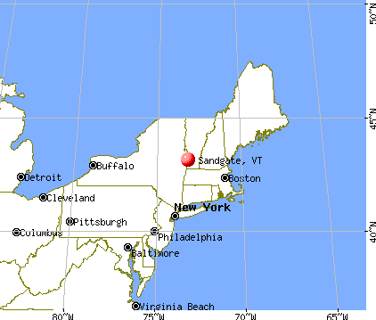
Nearest city with pop. 50,000+: Schenectady, NY  (44.6 miles , pop. 61,821).
Nearest city with pop. 200,000+: Boston, MA (121.2 miles , pop. 589,141).
Nearest city with pop. 1,000,000+: Bronx, NY (163.4 miles , pop. 1,332,650).
Nearest cities:
)Latitude: 43.15 N, Longitude: 73.19 W
Area code commonly used in this area: 802

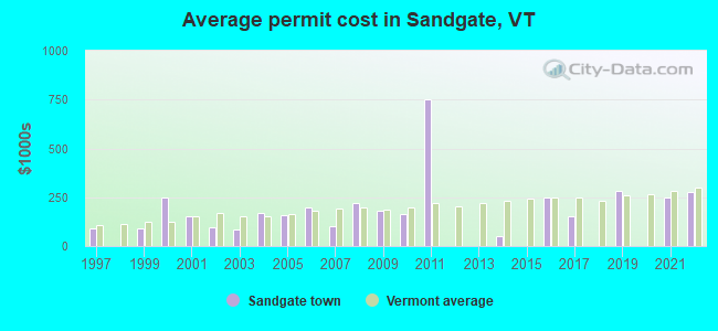
Single-family new house construction building permits:
- 2022: 1 building, cost: $279,200
- 2021: 2 buildings, average cost: $248,200
- 2019: 1 building, cost: $282,200
- 2017: 1 building, cost: $150,000
- 2016: 1 building, cost: $246,000
- 2014: 1 building, cost: $50,000
- 2011: 1 building, cost: $750,000
- 2010: 2 buildings, average cost: $165,900
- 2009: 5 buildings, average cost: $178,900
- 2008: 5 buildings, average cost: $219,000
- 2007: 1 building, cost: $100,000
- 2006: 3 buildings, average cost: $200,000
- 2005: 9 buildings, average cost: $155,600
- 2004: 3 buildings, average cost: $166,700
- 2003: 1 building, cost: $85,000
- 2002: 1 building, cost: $95,000
- 2001: 2 buildings, average cost: $150,000
- 2000: 1 building, cost: $250,000
- 1999: 4 buildings, average cost: $87,500
- 1997: 1 building, cost: $91,700

| Here: | 3.2% |
| Vermont: | 2.0% |
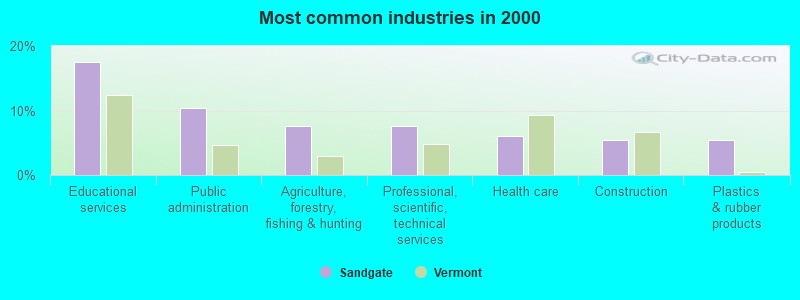
- Educational services (17.5%)
- Public administration (10.4%)
- Agriculture, forestry, fishing & hunting (7.7%)
- Professional, scientific, technical services (7.7%)
- Health care (6.0%)
- Construction (5.5%)
- Plastics & rubber products (5.5%)
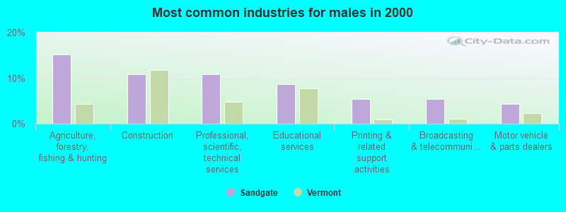
- Agriculture, forestry, fishing & hunting (15.2%)
- Construction (10.9%)
- Professional, scientific, technical services (10.9%)
- Educational services (8.7%)
- Printing & related support activities (5.4%)
- Broadcasting & telecommunications (5.4%)
- Motor vehicle & parts dealers (4.3%)
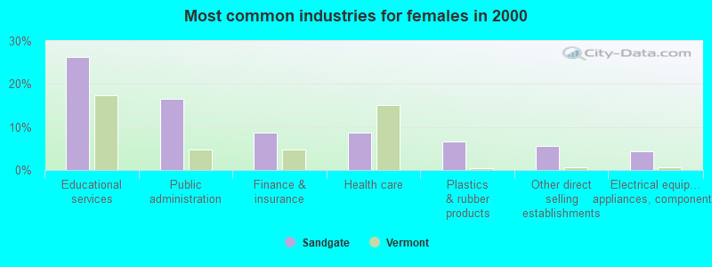
- Educational services (26.4%)
- Public administration (16.5%)
- Finance & insurance (8.8%)
- Health care (8.8%)
- Plastics & rubber products (6.6%)
- Other direct selling establishments (5.5%)
- Electrical equipment, appliances, components (4.4%)
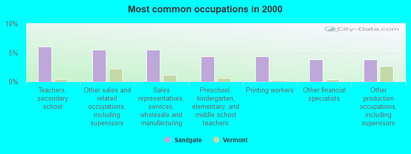
- Teachers, secondary school (6.0%)
- Other sales and related occupations, including supervisors (5.5%)
- Sales representatives, services, wholesale and manufacturing (5.5%)
- Preschool, kindergarten, elementary, and middle school teachers (4.4%)
- Printing workers (4.4%)
- Other financial specialists (3.8%)
- Other production occupations, including supervisors (3.8%)
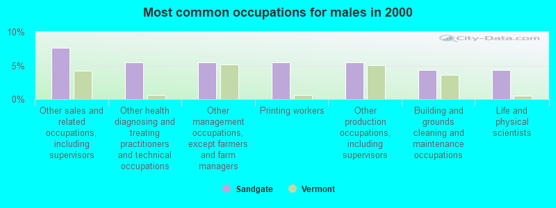
- Other sales and related occupations, including supervisors (7.6%)
- Other health diagnosing and treating practitioners and technical occupations (5.4%)
- Other management occupations, except farmers and farm managers (5.4%)
- Printing workers (5.4%)
- Other production occupations, including supervisors (5.4%)
- Building and grounds cleaning and maintenance occupations (4.3%)
- Life and physical scientists (4.3%)
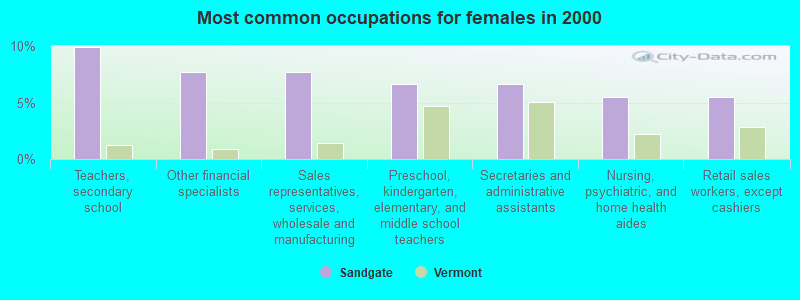
- Teachers, secondary school (9.9%)
- Other financial specialists (7.7%)
- Sales representatives, services, wholesale and manufacturing (7.7%)
- Preschool, kindergarten, elementary, and middle school teachers (6.6%)
- Secretaries and administrative assistants (6.6%)
- Nursing, psychiatric, and home health aides (5.5%)
- Retail sales workers, except cashiers (5.5%)
Average climate in Sandgate, Vermont
Based on data reported by over 4,000 weather stations


(lower is better)
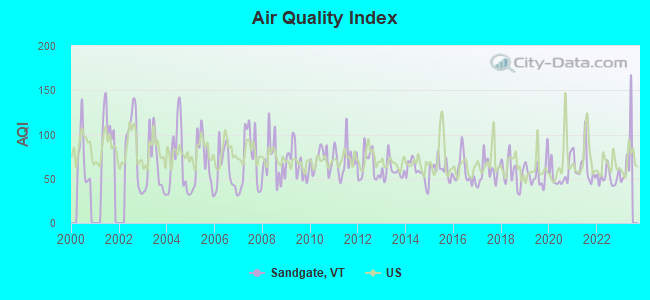
Air Quality Index (AQI) level in 2022 was 51.9. This is better than average.
| City: | 51.9 |
| U.S.: | 72.6 |
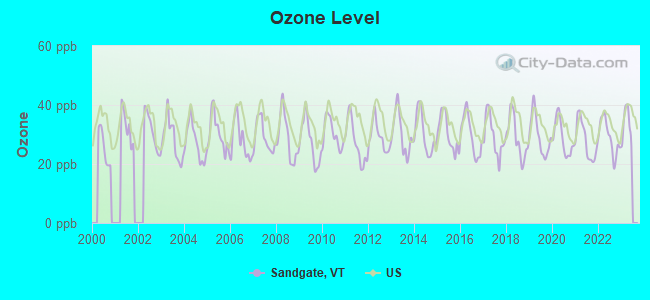
Ozone [ppb] level in 2022 was 29.1. This is about average. Closest monitor was 18.7 miles away from the city center.
| City: | 29.1 |
| U.S.: | 33.3 |
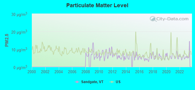
Particulate Matter (PM2.5) [µg/m3] level in 2022 was 5.56. This is significantly better than average. Closest monitor was 18.7 miles away from the city center.
| City: | 5.56 |
| U.S.: | 8.11 |
Tornado activity:
Sandgate-area historical tornado activity is above Vermont state average. It is 51% smaller than the overall U.S. average.
On 5/31/1998, a category F3 (max. wind speeds 158-206 mph) tornado 15.5 miles away from the Sandgate town center injured 68 people and caused $71 million in damages.
On 8/20/1968, a category F3 tornado 20.0 miles away from the town center injured one person and caused between $5000 and $50,000 in damages.
Earthquake activity:
Sandgate-area historical earthquake activity is significantly above Vermont state average. It is 69% smaller than the overall U.S. average.On 10/7/1983 at 10:18:46, a magnitude 5.3 (5.1 MB, 5.3 LG, 5.1 ML, Class: Moderate, Intensity: VI - VII) earthquake occurred 80.0 miles away from the city center
On 4/20/2002 at 10:50:47, a magnitude 5.3 (5.3 ML, Depth: 3.0 mi) earthquake occurred 97.3 miles away from the city center
On 4/20/2002 at 10:50:47, a magnitude 5.2 (5.2 MB, 4.2 MS, 5.2 MW, 5.0 MW) earthquake occurred 95.9 miles away from Sandgate center
On 1/19/1982 at 00:14:42, a magnitude 4.7 (4.5 MB, 4.7 MD, 4.5 LG, Class: Light, Intensity: IV - V) earthquake occurred 83.5 miles away from the city center
On 10/16/2012 at 23:12:25, a magnitude 4.7 (4.7 ML, Depth: 10.0 mi) earthquake occurred 131.0 miles away from Sandgate center
On 6/17/1991 at 08:53:16, a magnitude 4.1 (4.0 MB, 4.0 LG, Depth: 3.1 mi) earthquake occurred 83.7 miles away from Sandgate center
Magnitude types: regional Lg-wave magnitude (LG), body-wave magnitude (MB), duration magnitude (MD), local magnitude (ML), surface-wave magnitude (MS), moment magnitude (MW)
Natural disasters:
The number of natural disasters in Bennington County (15) is near the US average (15).Major Disasters (Presidential) Declared: 10
Emergencies Declared: 2
Causes of natural disasters: Floods: 8, Storms: 8, Tropical Storms: 2, Winter Storms: 2, Hurricane: 1, Landslide: 1, Snowstorm: 1, Wind: 1, Other: 1 (Note: some incidents may be assigned to more than one category).

Colleges/universities with over 2000 students nearest to Sandgate:
- Adirondack Community College (about 28 miles; Queensbury, NY; Full-time enrollment: 2,826)
- SUNY Empire State College (about 31 miles; Saratoga Springs, NY; FT enrollment: 9,473)
- Skidmore College (about 31 miles; Saratoga Springs, NY; FT enrollment: 2,753)
- Williams College (about 31 miles; Williamstown, MA; FT enrollment: 2,141)
- Castleton State College (about 32 miles; Castleton, VT; FT enrollment: 2,079)
- Rensselaer Polytechnic Institute (about 39 miles; Troy, NY; FT enrollment: 6,940)
- The Sage Colleges (about 39 miles; Troy, NY; FT enrollment: 2,499)
Points of interest:
Notable location: Sandgate Town Hall (A). Display/hide its location on the map
Church in Sandgate: Sandgate Methodist Church (A). Display/hide its location on the map
Cemeteries: Beartown Cemetery (1), Wilcox Cemetery (2), West End-Camdon Valley Cemetery (3), Sherman Cemetery (4), Scott Cemetery (5), Sandgate Center Cemetery (6). Display/hide their locations on the map
Lakes and reservoirs: Hopper Pond (A), Lake Madeleine (B), Barbos Lake (C). Display/hide their locations on the map
Streams, rivers, and creeks: Pruddy Brook (A), Norton Brook (B), Devils Glen Brook (C), Baker Brook (D), Terry Brook (E), Baldwin Brook (F), Hopper Brook (G), Brown Brook (H). Display/hide their locations on the map
Birthplace of: Ormsby B. Thomas - Politician.
| This town: | 2.4 people |
| Vermont: | 2.3 people |
| This town: | 67.9% |
| Whole state: | 62.5% |
| This town: | 7.4% |
| Whole state: | 9.2% |
No gay or lesbian households reported
| This town: | 12.7% |
| Whole state: | 9.4% |
| This town: | 3.1% |
| Whole state: | 3.6% |
For population 15 years and over in Sandgate:
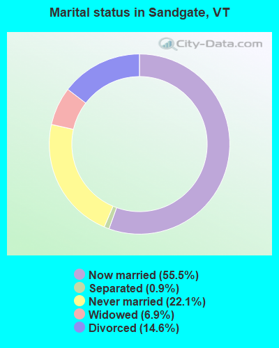
- Never married: 22.1%
- Now married: 55.5%
- Separated: 0.9%
- Widowed: 6.9%
- Divorced: 14.6%
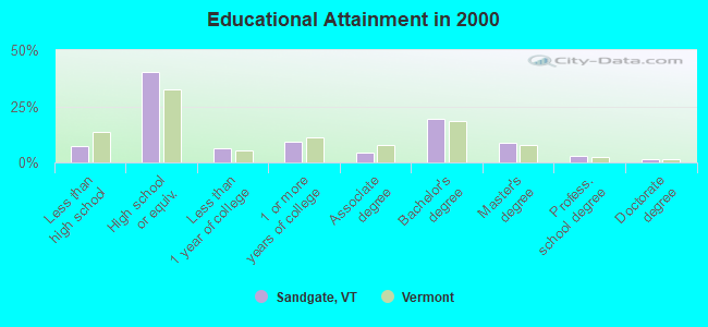
For population 25 years and over in Sandgate:
- High school or higher: 92.9%
- Bachelor's degree or higher: 32.9%
- Graduate or professional degree: 13.2%
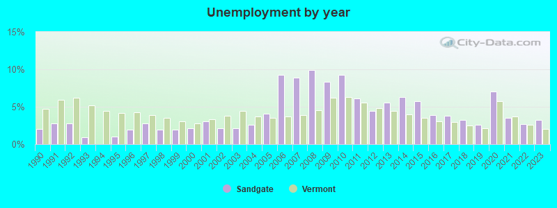
- Unemployed: 4.7%
- Mean travel time to work (commute): 29.8 minutes
| Here: | 10.5 |
| Vermont average: | 11.7 |
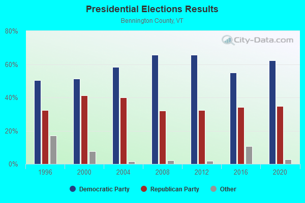
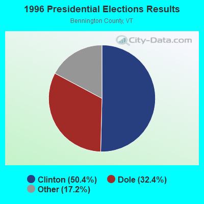
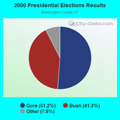
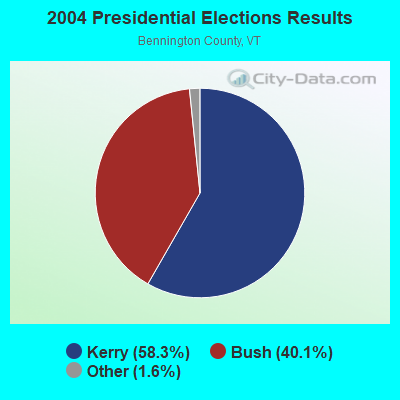
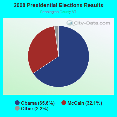
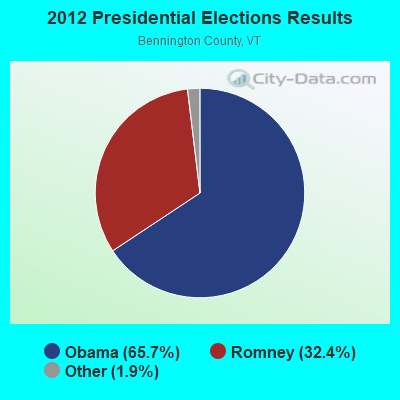
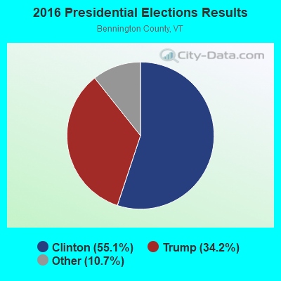
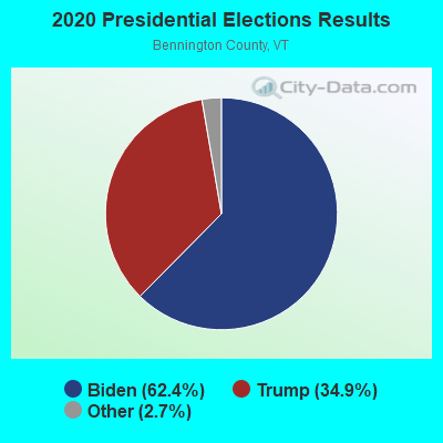
Graphs represent county-level data. Detailed 2008 Election Results
Religion statistics for Sandgate, VT (based on Bennington County data)

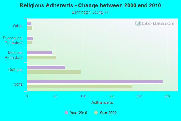
| Religion | Adherents | Congregations |
|---|---|---|
| Catholic | 6,742 | 8 |
| Mainline Protestant | 4,490 | 26 |
| Evangelical Protestant | 1,005 | 12 |
| Other | 693 | 5 |
| None | 24,195 | - |
Food Environment Statistics:
| Bennington County: | 3.85 / 10,000 pop. |
| State: | 3.84 / 10,000 pop. |
| Bennington County: | 3.30 / 10,000 pop. |
| State: | 1.95 / 10,000 pop. |
| Bennington County: | 5.77 / 10,000 pop. |
| Vermont: | 6.40 / 10,000 pop. |
| Bennington County: | 16.48 / 10,000 pop. |
| Vermont: | 11.52 / 10,000 pop. |
| This county: | 8.4% |
| Vermont: | 6.8% |
| This county: | 22.9% |
| Vermont: | 22.3% |
| Here: | 11.6% |
| Vermont: | 13.3% |
Strongest AM radio stations in Sandgate:
- WGY (810 AM; 50 kW; SCHENECTADY, NY; Owner: CLEAR CHANNEL BROADCASTING LICENSES, INC.)
- WPTR (1540 AM; 50 kW; ALBANY, NY; Owner: KIMTRON, INC.)
- WNNZ (640 AM; 50 kW; WESTFIELD, MA; Owner: CLEAR CHANNEL BROADCASTING LICENSES, INC.)
- WCRN (830 AM; 50 kW; WORCESTER, MA; Owner: CARTER BROADCASTING CORPORATION)
- WRKO (680 AM; 50 kW; BOSTON, MA; Owner: ENTERCOM BOSTON LICENSE, LLC)
- WTIC (1080 AM; 50 kW; HARTFORD, CT; Owner: INFINITY RADIO OPERATIONS INC.)
- WABY (1160 AM; 5 kW; MECHANICVILLE, NY; Owner: ANASTOS MEDIA GROUP, INC.)
- WVNE (760 AM; daytime; 25 kW; LEICESTER, MA; Owner: BLOUNT MASSCOM, INC.)
- WEEI (850 AM; 50 kW; BOSTON, MA; Owner: ENTERCOM BOSTON LICENSE, LLC)
- WALE (990 AM; 50 kW; GREENVILLE, RI; Owner: NORTH AMERICAN BROADCASTING CO., INC.)
- WKOX (1200 AM; 50 kW; FRAMINGHAM, MA; Owner: CAPSTAR TX LIMITED PARTNERSHIP)
- WSYB (1380 AM; 5 kW; RUTLAND, VT; Owner: CAPSTAR TX LIMITED PARTNERSHIP)
- WNTK (1020 AM; 10 kW; NEWPORT, NH; Owner: KOOR COMMUNICATIONS, INC.)
Strongest FM radio stations in Sandgate:
- WEQX (102.7 FM; MANCHESTER, VT; Owner: NORTHSHIRE COMMUNICATIONS, INC.)
- WJAN (95.1 FM; SUNDERLAND, VT; Owner: 6 JOHNSON ROAD LICENSES, INC.)
- WNGN (91.9 FM; ARGYLE, NY; Owner: NORTHEAST GOSPEL BROADCASTING INC)
- WVAY (100.7 FM; WILMINGTON, VT; Owner: GREAT NORTHERN RADIO, L.L.C.)
- WJJR (98.1 FM; RUTLAND, VT; Owner: 6 JOHNSON ROAD LICENSES, INC.)
- WZRT (97.1 FM; RUTLAND, VT; Owner: CAPSTAR TX LIMITED PARTNERSHIP)
- WEBK (105.3 FM; KILLINGTON, VT; Owner: 6 JOHNSON ROAD LICENSES, INC.)
- WLJH (90.9 FM; GLENS FALLS, NY; Owner: SOUND OF LIFE INC)
- WGLV (91.7 FM; WOODSTOCK, VT; Owner: CHRISTIAN MINISTRIES INC)
- WHDQ-FM1 (106.1 FM; RUTLAND, VT; Owner: GREAT NORTHERN RADIO, L.L.C.)
- WAMC-FM (90.3 FM; ALBANY, NY; Owner: WAMC)
- WMNV (104.1 FM; RUPERT, VT; Owner: CAPITAL MEDIA CORPORATION)
- WVPR (89.5 FM; WINDSOR, VT; Owner: VERMONT PUBLIC RADIO)
- WZEC (97.5 FM; HOOSICK FALLS, NY; Owner: GREAT NORTHERN RADIO, LLC)
- WHDQ (106.1 FM; CLAREMONT, NH; Owner: GREAT NORTHERN RADIO, L.L.C.)
- WKBE (100.3 FM; WARRENSBURG, NY; Owner: 6 JOHNSON ROAD LICENSES, INC.)
- WCKM-FM (99.1 FM; LAKE GEORGE, NY; Owner: ENTERTRONICS, INC.)
- WNYQ (105.7 FM; QUEENSBURY, NY; Owner: VOX NEW YORK, L.L.C.)
- WBAR-FM (94.7 FM; LAKE LUZERNE, NY; Owner: CAPITAL MEDIA CORPORATION)
- WXLG (89.9 FM; NORTH CREEK, NY; Owner: THE ST. LAWRENCE UNIVERSITY)
TV broadcast stations around Sandgate:
- W36AX (Channel 36; MANCHESTER, ETC., VT; Owner: VERMONT ETV, INC.)
- W69AD (Channel 69; BENNINGTON, ETC., VT; Owner: MT. MANSFIELD TELEVISION, INC.)
- WNYA-CA (Channel 39; EASTON, ETC., NY; Owner: VENTURE TECHNOLOGIES GROUP, LLC)
- WVBK-LP (Channel 49; MANCHESTER, ETC., VT; Owner: VISION 3 BROADCASTING, INC.)
Sandgate fatal accident list:
Sep 5, 1988 01:00 PM, 4, Vehicles: 1, Persons: 1, Fatalities: 1
- National Bridge Inventory (NBI) Statistics
- 7Number of bridges
- 33ft / 9.5mTotal length
- $2,101,000Total costs
- 1,205Total average daily traffic
- 23Total average daily truck traffic
- 1,267Total future (year 2026) average daily traffic
FCC Registered Amateur Radio Licenses:
2- Call Sign: WA1DMT, Licensee ID: L00495481, Grant Date: 02/26/2008, Expiration Date: 04/16/2018, Cancellation Date: 04/17/2020, Certifier: Douglas A Tschorn, Registrant: Douglas A Tschorn, 679 Lincoln Ln, Sandgate, VT 05250-9603
- Call Sign: WA1DMU, Licensee ID: L00762166, Grant Date: 01/23/2018, Expiration Date: 04/17/2028, Certifier: Nancy J Tschorn, Registrant: Nancy J Tschorn, 679 Lincoln Ln, Sandgate, VT 05250
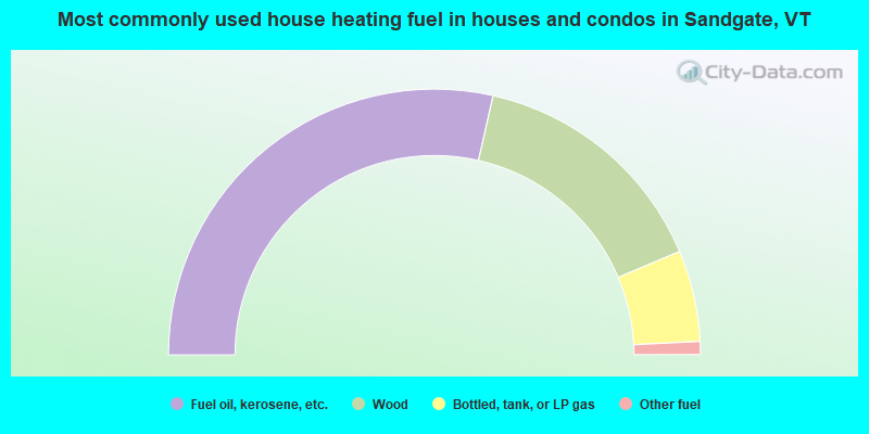
- 57.1%Fuel oil, kerosene, etc.
- 30.2%Wood
- 11.1%Bottled, tank, or LP gas
- 1.6%Other fuel
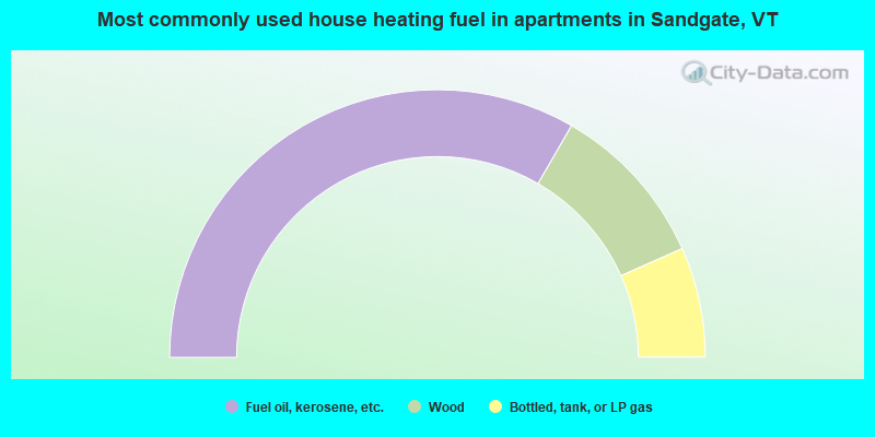
- 66.7%Fuel oil, kerosene, etc.
- 20.0%Wood
- 13.3%Bottled, tank, or LP gas
Sandgate compared to Vermont state average:
- Unemployed percentage below state average.
- Renting percentage below state average.
- Length of stay since moving in significantly above state average.
- Number of rooms per house significantly below state average.
- House age significantly below state average.
- Number of college students significantly below state average.

|
Total of 1 patent application in 2008-2024.