Sedalia, Missouri
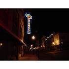
Sedalia: Downtown Sedalia: Hotel Bothwell
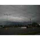
Sedalia: before storm
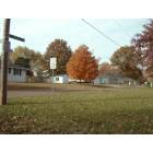
Sedalia: Fall colours, Corner of S Arlington, October 2007... takn by G Norton, Nottinghamshire, England, UK. whilst visiting Sedalia

Sedalia: Sedalia Church
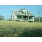
Sedalia: ghosthouse
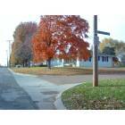
Sedalia: An autumn tree on corner of Arlington South, taken whilst on vaction visitng ith my wifes cousin. .... Geoff & Marilyn, Nottinghamshire, England, UK.

Sedalia: this picture was at the Midwest Dragfest in Sedalia
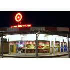
Sedalia: A very old drive in restaurant in Sedalia, MO
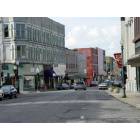
Sedalia: Beautiful Downtown Area

Sedalia: Broadway Blvd. in the Fall

Sedalia: Seddalia Trust Building Downtown
- see
18
more - add
your
Submit your own pictures of this city and show them to the world
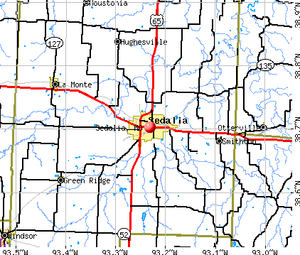
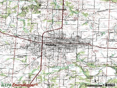
- OSM Map
- General Map
- Google Map
- MSN Map
Population change since 2000: +7.9%
 |
| Males: 10,698 | |
| Females: 11,249 |
| Median resident age: | 36.6 years |
| Missouri median age: | 39.1 years |
Zip codes: 65301.
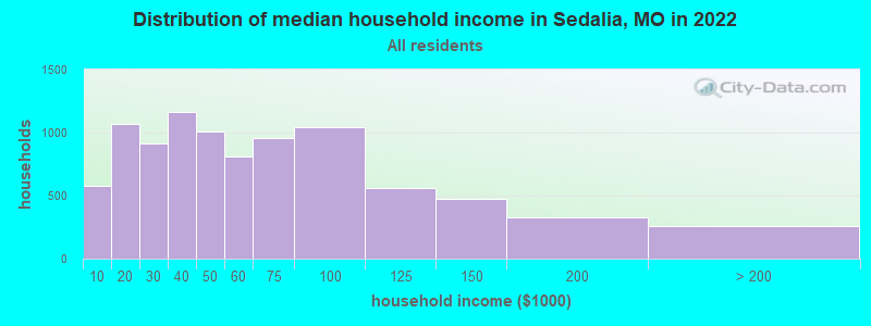
| Sedalia: | $47,702 |
| MO: | $64,811 |
Estimated per capita income in 2022: $27,804 (it was $15,931 in 2000)
Sedalia city income, earnings, and wages data
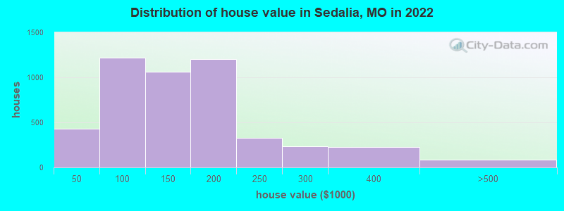
Estimated median house or condo value in 2022: $141,107 (it was $59,600 in 2000)
| Sedalia: | $141,107 |
| MO: | $221,200 |
Mean prices in 2022: all housing units: $213,572; detached houses: $220,177; townhouses or other attached units: $124,511; in 2-unit structures: $158,621; in 3-to-4-unit structures: $41,105; in 5-or-more-unit structures: $415,101; mobile homes: $129,495
Median gross rent in 2022: $822.
(16.6% for White Non-Hispanic residents, 28.0% for Black residents, 18.0% for Hispanic or Latino residents, 100.0% for Native Hawaiian and other Pacific Islander residents, 16.6% for other race residents, 16.3% for two or more races residents)
Detailed information about poverty and poor residents in Sedalia, MO


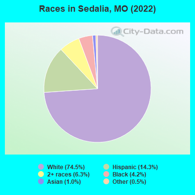
- 16,26874.5%White alone
- 3,13214.3%Hispanic
- 1,3726.3%Two or more races
- 9234.2%Black alone
- 2271.0%Asian alone
- 1110.5%Other race alone
- 110.05%Native Hawaiian and Other
Pacific Islander alone - 90.04%American Indian alone
Races in Sedalia detailed stats: ancestries, foreign born residents, place of birth
According to our research of Missouri and other state lists, there were 188 registered sex offenders living in Sedalia, Missouri as of April 27, 2024.
The ratio of all residents to sex offenders in Sedalia is 115 to 1.
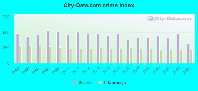
Type |
2009 |
2010 |
2011 |
2012 |
2013 |
2014 |
2015 |
2016 |
2017 |
2018 |
2019 |
2020 |
2021 |
2022 |
|---|---|---|---|---|---|---|---|---|---|---|---|---|---|---|
| Murders (per 100,000) | 1 (4.7) | 2 (9.4) | 2 (9.3) | 0 (0.0) | 0 (0.0) | 0 (0.0) | 1 (4.6) | 1 (4.6) | 0 (0.0) | 1 (4.6) | 1 (4.6) | 1 (4.6) | 2 (9.2) | 0 (0.0) |
| Rapes (per 100,000) | 6 (28.5) | 3 (14.0) | 4 (18.6) | 5 (23.3) | 7 (32.6) | 8 (37.2) | 12 (55.8) | 5 (23.2) | 10 (46.5) | 11 (50.9) | 16 (73.6) | 28 (129.4) | 52 (239.6) | 28 (127.7) |
| Robberies (per 100,000) | 24 (113.9) | 20 (93.5) | 11 (51.2) | 15 (70.0) | 14 (65.1) | 15 (69.7) | 27 (125.5) | 11 (51.1) | 8 (37.2) | 10 (46.3) | 9 (41.4) | 10 (46.2) | 7 (32.3) | 7 (31.9) |
| Assaults (per 100,000) | 142 (674.1) | 127 (593.8) | 130 (605.6) | 81 (378.2) | 101 (469.9) | 114 (529.9) | 129 (599.6) | 102 (473.6) | 133 (618.6) | 161 (745.7) | 162 (745.1) | 143 (660.8) | 90 (414.7) | 73 (333.0) |
| Burglaries (per 100,000) | 283 (1,343) | 280 (1,309) | 302 (1,407) | 378 (1,765) | 329 (1,531) | 204 (948.3) | 211 (980.8) | 176 (817.2) | 182 (846.5) | 118 (546.5) | 175 (804.9) | 134 (619.3) | 132 (608.2) | 131 (597.5) |
| Thefts (per 100,000) | 1,056 (5,013) | 968 (4,526) | 1,121 (5,222) | 1,173 (5,477) | 1,110 (5,164) | 1,101 (5,118) | 938 (4,360) | 870 (4,040) | 863 (4,014) | 774 (3,585) | 714 (3,284) | 538 (2,486) | 597 (2,751) | 429 (1,957) |
| Auto thefts (per 100,000) | 51 (242.1) | 53 (247.8) | 69 (321.5) | 61 (284.8) | 63 (293.1) | 62 (288.2) | 60 (278.9) | 52 (241.5) | 80 (372.1) | 52 (240.9) | 65 (299.0) | 46 (212.6) | 71 (327.2) | 57 (260.0) |
| Arson (per 100,000) | 7 (33.2) | 7 (32.7) | 6 (28.0) | 8 (37.4) | 2 (9.3) | 4 (18.6) | 7 (32.5) | 6 (27.9) | 3 (14.0) | 3 (13.9) | 7 (32.2) | 2 (9.2) | 10 (46.1) | 2 (9.1) |
| City-Data.com crime index | 515.2 | 469.3 | 503.1 | 480.8 | 476.7 | 450.8 | 476.9 | 376.0 | 421.7 | 414.0 | 441.1 | 418.6 | 481.5 | 319.2 |
The City-Data.com crime index weighs serious crimes and violent crimes more heavily. Higher means more crime, U.S. average is 246.1. It adjusts for the number of visitors and daily workers commuting into cities.
Crime rate in Sedalia detailed stats: murders, rapes, robberies, assaults, burglaries, thefts, arson
Full-time law enforcement employees in 2021, including police officers: 49 (43 officers - 38 male; 5 female).
| Officers per 1,000 residents here: | 1.98 |
| Missouri average: | 2.54 |
 Recent articles from our blog. Our writers, many of them Ph.D. graduates or candidates, create easy-to-read articles on a wide variety of topics.

 | Lee's Summit/Warrensburg/Sedalia topography (5 replies) |
| Ruskin Heights? Independance? (22 replies) |
| Moving to Sedalia (1 reply) |
| Missouri Outlaw History (3407 replies) |
| Sedalia vs. Boonville vs. California, MO (12 replies) |
| Motel Sedalia? (4 replies) |
Latest news from Sedalia, MO collected exclusively by city-data.com from local newspapers, TV, and radio stations
Ancestries: American (17.1%), German (16.0%), English (6.7%), Irish (3.8%), European (2.5%), Ukrainian (1.7%).
Current Local Time: CST time zone
Incorporated in 1864
Elevation: 919 feet
Land area: 12.0 square miles.
Population density: 1,835 people per square mile (low).
1,757 residents are foreign born (5.7% Latin America, 1.6% Europe, 0.9% Asia).
| This city: | 8.0% |
| Missouri: | 4.2% |
Median real estate property taxes paid for housing units with mortgages in 2022: $1,052 (0.7%)
Median real estate property taxes paid for housing units with no mortgage in 2022: $1,025 (0.7%)
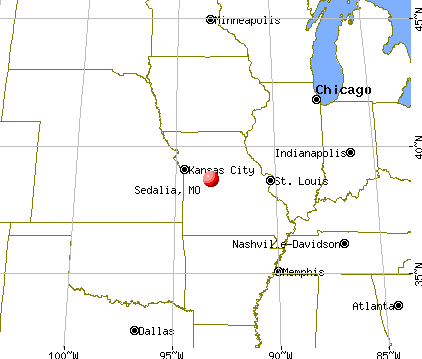
Nearest city with pop. 50,000+: Columbia, MO  (51.2 miles , pop. 84,531).
Nearest city with pop. 200,000+: Kansas City, MO (75.8 miles , pop. 441,545).
Nearest city with pop. 1,000,000+: Chicago, IL (364.5 miles , pop. 2,896,016).
Nearest cities:
), ), ), ), )Latitude: 38.70 N, Longitude: 93.23 W
Daytime population change due to commuting: +5,655 (+25.9%)
Workers who live and work in this city: 7,474 (74.3%)
Area codes: 660, 816

Sedalia, Missouri accommodation & food services, waste management - Economy and Business Data
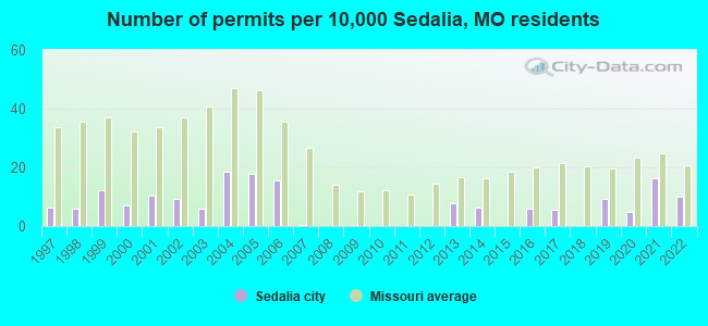
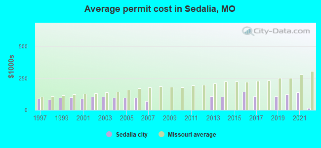
Single-family new house construction building permits:
- 2022: 20 buildings, average cost: $14,900
- 2021: 33 buildings, average cost: $137,800
- 2020: 10 buildings, average cost: $125,300
- 2019: 19 buildings, average cost: $107,300
- 2017: 11 buildings, average cost: $109,500
- 2016: 12 buildings, average cost: $142,100
- 2014: 13 buildings, average cost: $103,100
- 2013: 16 buildings, average cost: $108,700
- 2007: 1 building, cost: $70,000
- 2006: 32 buildings, average cost: $96,200
- 2005: 36 buildings, average cost: $96,200
- 2004: 38 buildings, average cost: $96,200
- 2003: 12 buildings, average cost: $104,500
- 2002: 19 buildings, average cost: $106,300
- 2001: 21 buildings, average cost: $89,800
- 2000: 14 buildings, average cost: $102,100
- 1999: 25 buildings, average cost: $96,300
- 1998: 12 buildings, average cost: $80,300
- 1997: 13 buildings, average cost: $88,500
| Here: | 2.6% |
| Missouri: | 2.8% |
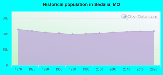
Population change in the 1990s: +469 (+2.4%).
- Health care (7.4%)
- Educational services (7.3%)
- Construction (7.1%)
- Accommodation & food services (6.6%)
- Metal & metal products (5.7%)
- Food (5.2%)
- Social assistance (3.7%)
- Construction (12.1%)
- Metal & metal products (7.5%)
- Food (6.2%)
- Accommodation & food services (5.9%)
- Transportation equipment (5.1%)
- Public administration (3.5%)
- Educational services (3.2%)
- Health care (12.4%)
- Educational services (12.1%)
- Accommodation & food services (7.3%)
- Social assistance (6.7%)
- Department & other general merchandise stores (4.7%)
- Food (4.1%)
- Electrical equipment, appliances, components (4.0%)
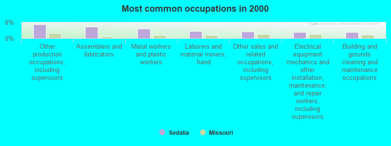
- Other production occupations, including supervisors (7.1%)
- Assemblers and fabricators (5.8%)
- Metal workers and plastic workers (4.7%)
- Laborers and material movers, hand (3.7%)
- Other sales and related occupations, including supervisors (3.5%)
- Electrical equipment mechanics and other installation, maintenance, and repair workers, including supervisors (3.2%)
- Building and grounds cleaning and maintenance occupations (3.1%)
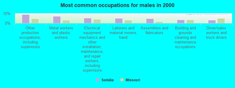
- Other production occupations, including supervisors (9.1%)
- Metal workers and plastic workers (7.2%)
- Electrical equipment mechanics and other installation, maintenance, and repair workers, including supervisors (5.5%)
- Laborers and material movers, hand (5.0%)
- Assemblers and fabricators (4.8%)
- Building and grounds cleaning and maintenance occupations (3.6%)
- Driver/sales workers and truck drivers (3.4%)
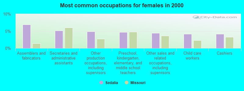
- Assemblers and fabricators (6.9%)
- Secretaries and administrative assistants (5.2%)
- Other production occupations, including supervisors (4.9%)
- Preschool, kindergarten, elementary, and middle school teachers (4.7%)
- Other sales and related occupations, including supervisors (4.4%)
- Child care workers (4.2%)
- Cashiers (4.1%)
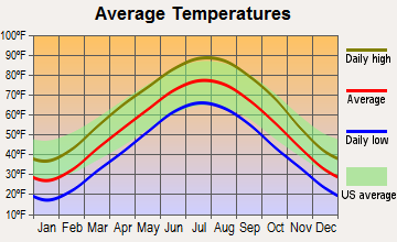
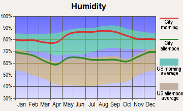
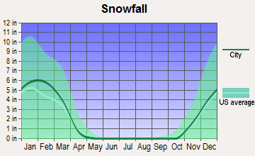
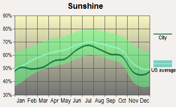
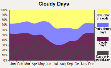
Average climate in Sedalia, Missouri
Based on data reported by over 4,000 weather stations


|
|

Tornado activity:
Sedalia-area historical tornado activity is slightly below Missouri state average. It is 40% greater than the overall U.S. average.
On 4/19/1973, a category F4 (max. wind speeds 207-260 mph) tornado 20.1 miles away from the Sedalia city center injured 5 people and caused between $5000 and $50,000 in damages.
On 5/4/1977, a category F3 (max. wind speeds 158-206 mph) tornado 1.3 miles away from the city center injured 24 people and caused between $5,000,000 and $50,000,000 in damages.
Earthquake activity:
Sedalia-area historical earthquake activity is significantly above Missouri state average. It is 456% greater than the overall U.S. average.On 9/3/2016 at 12:02:44, a magnitude 5.8 (5.8 MW, Depth: 3.5 mi, Class: Moderate, Intensity: VI - VII) earthquake occurred 256.7 miles away from Sedalia center
On 11/6/2011 at 03:53:10, a magnitude 5.7 (5.7 MW, Depth: 3.2 mi) earthquake occurred 293.4 miles away from Sedalia center
On 4/18/2008 at 09:36:59, a magnitude 5.4 (5.1 MB, 4.8 MS, 5.4 MW, 5.2 MW) earthquake occurred 289.5 miles away from Sedalia center
On 9/26/1990 at 13:18:51, a magnitude 5.0 (4.7 MB, 4.8 LG, 5.0 LG, Depth: 7.7 mi) earthquake occurred 227.9 miles away from Sedalia center
On 5/4/1991 at 01:18:54, a magnitude 5.0 (4.4 MB, 4.6 LG, 5.0 LG, Depth: 3.1 mi) earthquake occurred 238.2 miles away from Sedalia center
On 4/18/2008 at 09:36:59, a magnitude 5.2 (5.2 MW, Depth: 8.9 mi) earthquake occurred 289.5 miles away from the city center
Magnitude types: regional Lg-wave magnitude (LG), body-wave magnitude (MB), surface-wave magnitude (MS), moment magnitude (MW)
Natural disasters:
The number of natural disasters in Pettis County (20) is greater than the US average (15).Major Disasters (Presidential) Declared: 14
Emergencies Declared: 5
Causes of natural disasters: Floods: 11, Storms: 10, Tornadoes: 8, Winter Storms: 4, Drought: 1, Heavy Rain: 1, Hurricane: 1, Ice Storm: 1, Snowstorm: 1, Wind: 1, Other: 1 (Note: some incidents may be assigned to more than one category).
Hospitals and medical centers in Sedalia:
- BOTHWELL REGIONAL HEALTH CENTER (Government - Local, provides emergency services, 601 E 14TH ST)
- FIRST AMERICAN HOME CARE OF MO, INC (117 EAST BROADWAY)
- BROOKING PARK GERIATRIC INC (RT 6 BOX 1567)
- FAIR VIEW NURSING HOME (1714 W 16TH STREET)
- FOUR SEASONS LIVING CENTER (2800 HIGHWAY TT)
- REST HAVEN CONVALESCENT AND RETIREMENT HOME (1800 SOUTH INGRAM)
- SYLVIA G THOMPSON RESIDENCE CENTER, INC (3333 W TENTH STREET)
- DIALYSIS CLINICS, INC - SEDALIA (950 MITCHELL RD)
- BOTHWELL REGIONAL HEALTH CENTER HOME CARE SERVICE (PO BOX 1706)
Airports and heliports located in Sedalia:
- Sedalia Regional Airport (DMO) (Runways: 2, Itinerant Ops: 4,400, Local Ops: 3,850, Military Ops: 2,750)
- Homan Field Airport (MO08) (Runways: 1)
- Bothwell Regional Health Center Heliport (86MO)
Colleges/Universities in Sedalia:
- State Fair Community College (Full-time enrollment: 3,581; Location: 3201 W 16th Street; Public; Website: www.sfccmo.edu)
- American College of Hair Design Inc (Full-time enrollment: 40; Location: 125 Winchester Drive; Private, for-profit; Website: www.americancollegeofhairdesign.com)
- Academy of Salon Professionals (Full-time enrollment: 27; Location: 2414 S. Limit Ave; Private, for-profit; Website: academyofsalonprofessionals.com/Home_Page.html)
Other colleges/universities with over 2000 students near Sedalia:
- University of Central Missouri (about 28 miles; Warrensburg, MO; Full-time enrollment: 9,952)
- University of Missouri-Columbia (about 52 miles; Columbia, MO; FT enrollment: 29,599)
- Columbia College (about 52 miles; Columbia, MO; FT enrollment: 13,975)
- Lincoln University (about 59 miles; Jefferson City, MO; FT enrollment: 2,348)
- Moberly Area Community College (about 65 miles; Moberly, MO; FT enrollment: 3,977)
- Rockhurst University (about 76 miles; Kansas City, MO; FT enrollment: 2,013)
- University of Missouri-Kansas City (about 77 miles; Kansas City, MO; FT enrollment: 10,544)
Public high schools in Sedalia:
- SMITH-COTTON HIGH SCHOOL (Students: 1,258, Location: 2010 TIGER PRIDE BOULEVARD, Grades: 10-12)
- STATE FAIR (Location: 3201 WEST 16TH STREET, Grades: 9-12)
- E W THOMPSON SCHOOL (Location: 1520 THOMPSON BLVD, Grades: KG-12)
- SMITH COTTON JUNIOR HIGH SCHL (Location: 312 EAST BROADWAY, Grades: 7-9)
Private high schools in Sedalia:
Public elementary/middle schools in Sedalia:
- SEDALIA MIDDLE SCHOOL (Students: 946, Location: 2205 S INGRAM, Grades: 5-6)
- HEBER HUNT ELEM. (Students: 558, Location: 600 S WARREN, Grades: KG-4)
- SKYLINE ELEM. (Students: 478, Location: 2505 W 32ND ST, Grades: KG-4)
- PARKVIEW ELEM. (Students: 468, Location: 1901 S NEW YORK, Grades: KG-4)
- HORACE MANN ELEM. (Students: 379, Location: 1100 W 16TH, Grades: KG-4)
- WASHINGTON ELEM. (Students: 306, Location: 610 S ENGINEER, Grades: KG-4)
- PETTIS CO. ELEM. (Students: 164, Location: 22675 DEPOT RD, Grades: PK-8)
Private elementary/middle school in Sedalia:
Libraries in Sedalia:
- BOONSLICK REGIONAL LIBRARY (Operating income: $1,205,904; Location: 219 WEST THIRD STREET; 182,882 books; 7,470 e-books; 5,430 audio materials; 4,451 video materials; 4 local licensed databases; 14 state licensed databases; 2 other licensed databases; 164 print serial subscriptions; 11 electronic serial subscriptions)
- SEDALIA PUBLIC LIBRARY (Operating income: $537,921; Location: 311 W. THIRD STREET; 67,372 books; 6,476 e-books; 790 audio materials; 2,973 video materials; 5 local licensed databases; 14 state licensed databases; 158 print serial subscriptions; 11 electronic serial subscriptions)
Points of interest:
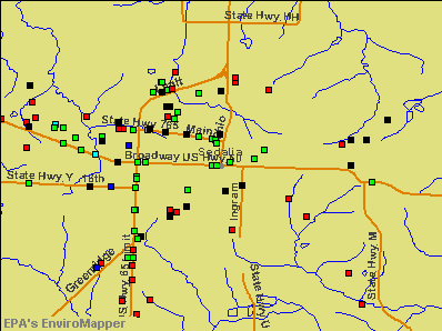
Notable locations in Sedalia: Department of Conservation Kansas City Regional Field Fire Office Sedalia (A), Pettis County Fire Protection District 1 Station 1 (B), Sedalia Fire Department Station 2 (C), Sedalia Fire Department Central Fire Station (D). Display/hide their locations on the map
Shopping Centers: Thompson Hills Shopping Center (1), State Fair Shopping Center (2). Display/hide their locations on the map
Cemeteries: Hebrew Cemetery (1), Memorial Park Cemetery (2), Crown Hill Cemetery (3). Display/hide their locations on the map
Parks in Sedalia include: Vermont Park (1), Liberty Park (2), Hubbard Park (3), Howsel Park (4), State Fairground Racetrack (5), Centennial Park (6). Display/hide their locations on the map
Tourist attractions: Bothwell Lodge State Historic Site (Museums; 19350 Bothwell Stte Park R) (1), Central Missouri Amusement CO (Amusement & Theme Parks; 401 South Engineer Avenue) (2). Display/hide their approximate locations on the map
Hotels: Hotel Bothwell (103 East 4th Street) (1), Comfort Inn Sedalia Station (3600 West Broadway) (2), Budget Host Super 7 Motel (5650 South Limit Avenue) (3), Best Western State Fair (South 65 Highway And 32nd Street) (4), Hotel Bothwell Clarion Collection (103 East 4th Street) (5). Display/hide their approximate locations on the map
Court: Pettis County - Court House- Juvenile Office- Division 6 (319 South Lamine Avenue Suite 9) (1). Display/hide its approximate location on the map
Birthplace of: Jack Oakie - Film actor, Ox Baker - Professional wrestler and actor, Charles G. Finney - Journalist, Clyde De Vinna - Cinematographer, James P. Fleming - Air Force Medal of Honor recipient, Kim Anderson (basketball) - Basketball player-coach, Bill Brown (broadcaster) - Baseball announcer, Bud Thomas (shortstop) - Baseball player, Dorothy Dwan - Actor, Doug Van Horn - Football player.
Drinking water stations with addresses in Sedalia and their reported violations in the past:
NORTH 65 CAFE (Population served: 150, Groundwater):Past monitoring violations:CRESTVIEW MHP (Population served: 72, Groundwater):
- 7 routine major monitoring violations
- One minor monitoring violation
Past health violations:STARDUST MOTOR INN (Address: 4710 S LIMIT , Population served: 33, Groundwater):Past monitoring violations:
- MCL, Monthly (TCR) - In DEC-2011, Contaminant: Coliform. Follow-up actions: St Violation/Reminder Notice (JAN-03-2012), St Public Notif requested (JAN-03-2012), St Compliance achieved (JAN-22-2014)
- MCL, Monthly (TCR) - In JUN-2010, Contaminant: Coliform. Follow-up actions: St Violation/Reminder Notice (JUL-08-2010), St Public Notif requested (JUL-08-2010), St Public Notif received (JUL-27-2010), St Compliance achieved (DEC-31-2010)
- MCL, Monthly (TCR) - In MAY-2010, Contaminant: Coliform. Follow-up actions: St Violation/Reminder Notice (JUN-04-2010), St Public Notif requested (JUN-04-2010), St Compliance achieved (DEC-31-2010)
- MCL, Monthly (TCR) - In MAY-2009, Contaminant: Coliform. Follow-up actions: St Violation/Reminder Notice (JUN-24-2009), St Public Notif requested (JUN-24-2009), St Compliance achieved (JAN-22-2014)
- MCL, Monthly (TCR) - In APR-2009, Contaminant: Coliform. Follow-up actions: St Violation/Reminder Notice (MAY-06-2009), St Public Notif requested (MAY-06-2009), St Compliance achieved (JAN-22-2014)
- MCL, Monthly (TCR) - In DEC-2007, Contaminant: Coliform. Follow-up actions: St Public Notif requested (JAN-03-2008), St Violation/Reminder Notice (JAN-03-2008), St Public Notif received (JAN-04-2008), St Violation/Reminder Notice (FEB-05-2008), St Compliance achieved (JAN-22-2014)
- 2 other older health violations
- Monitoring, Source Water (GWR) - In FEB-01-2012, Contaminant: E. COLI. Follow-up actions: St Public Notif requested (MAR-14-2012), St Violation/Reminder Notice (MAR-14-2012), St Public Notif received (JUL-05-2013)
- Lead Consumer Notice - In JAN-01-2011, Contaminant: Lead and Copper Rule
- Monitoring, Source Water (GWR) - In JUN-01-2010, Contaminant: E. COLI. Follow-up actions: St Public Notif requested (JUL-27-2010), St Violation/Reminder Notice (JUL-27-2010), St Public Notif received (AUG-19-2010)
- 3 routine major monitoring violations
- One minor monitoring violation
- 3 regular monitoring violations
Past monitoring violations:
- Monitoring, Source Water (GWR) - In SEP-01-2010, Contaminant: E. COLI. Follow-up actions: St Violation/Reminder Notice (OCT-22-2010), St Public Notif requested (OCT-22-2010)
- 5 routine major monitoring violations
Drinking water stations with addresses in Sedalia that have no violations reported:
- BRADEN PARK VILLAGE (Population served: 120, Primary Water Source Type: Purch groundwater)
| This city: | 2.4 people |
| Missouri: | 2.5 people |
| This city: | 59.1% |
| Whole state: | 65.3% |
| This city: | 9.1% |
| Whole state: | 6.7% |
Likely homosexual households (counted as self-reported same-sex unmarried-partner households)
- Lesbian couples: 0.4% of all households
- Gay men: 0.1% of all households
People in group quarters in Sedalia in 2010:
- 181 people in nursing facilities/skilled-nursing facilities
- 113 people in college/university student housing
- 107 people in local jails and other municipal confinement facilities
- 37 people in group homes intended for adults
- 24 people in other noninstitutional facilities
- 21 people in residential treatment centers for adults
- 9 people in emergency and transitional shelters (with sleeping facilities) for people experiencing homelessness
People in group quarters in Sedalia in 2000:
- 175 people in nursing homes
- 51 people in other noninstitutional group quarters
- 41 people in local jails and other confinement facilities (including police lockups)
- 28 people in college dormitories (includes college quarters off campus)
- 23 people in other group homes
- 7 people in homes for the mentally retarded
Banks with branches in Sedalia (2011 data):
- The Third National Bank of Sedalia: The Third National Bank Of Sedalia, Motor Bank 7 Downtown Branch, Motor Branch, South Limit Branch, Tnb Iii Branch, Sedalia Facility. Info updated 2011/10/05: Bank assets: $401.0 mil, Deposits: $355.7 mil, local headquarters, positive income, 7 total offices, Holding Company: Central Bancompany
- U.S. Bank National Association: Sedalia - West Fourth Branch, Sedalia-State Fair, Sedalia Main Branch. Info updated 2012/01/30: Bank assets: $330,470.8 mil, Deposits: $236,091.5 mil, headquarters in Cincinnati, OH, positive income, 3121 total offices, Holding Company: U.S. Bancorp
- Bank 21: Sedalia Branch East at 1650 East Broadway, branch established on 1973/05/17. Info updated 2010/08/12: Bank assets: $52.7 mil, Deposits: $46.2 mil, headquarters in Carrollton, MO, positive income, Commercial Lending Specialization, 5 total offices, Holding Company: Knott Holding Company, Inc.
- Central Bank of Missouri: Central Bank Of Missouri at 1601 South Limit, branch established on 1891/01/01. Info updated 2006/11/03: Bank assets: $81.3 mil, Deposits: $69.3 mil, local headquarters, negative income in the last year, Commercial Lending Specialization, 3 total offices, Holding Company: Warren County Bancshares, Inc.
- Excel Bank: at 818 Thompson Boulevard, branch established on 1964/07/30. Info updated 2010/08/05: Bank assets: $240.2 mil, Deposits: $205.3 mil, local headquarters, negative income in the last year, Commercial Lending Specialization, 4 total offices, Holding Company: Investors Financial Corporation Of Pettis County, Inc.
- First Community Bank: Sedalia Branch 60 at 920 Thompson Boulevard, branch established on 1998/07/13. Info updated 2010/08/12: Bank assets: $638.3 mil, Deposits: $567.3 mil, headquarters in Lees Summit, MO, positive income, Commercial Lending Specialization, 18 total offices, Holding Company: First Community Bancshares, Inc.
For population 15 years and over in Sedalia:
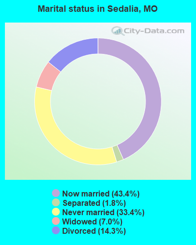
- Never married: 33.4%
- Now married: 43.4%
- Separated: 1.8%
- Widowed: 7.0%
- Divorced: 14.3%
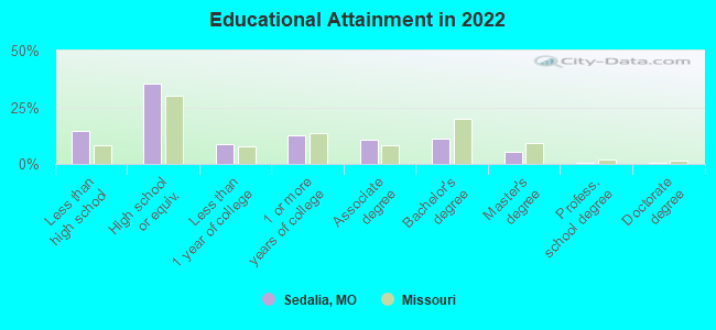
For population 25 years and over in Sedalia:
- High school or higher: 85.1%
- Bachelor's degree or higher: 17.0%
- Graduate or professional degree: 6.2%
- Unemployed: 5.8%
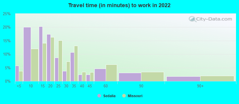
- Mean travel time to work (commute): 15.2 minutes
| Here: | 11.3 |
| Missouri average: | 11.1 |
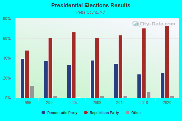
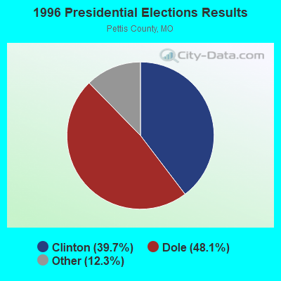
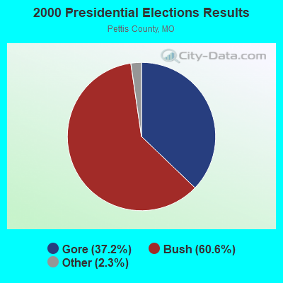

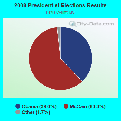


Graphs represent county-level data. Detailed 2008 Election Results
Religion statistics for Sedalia, MO (based on Pettis County data)
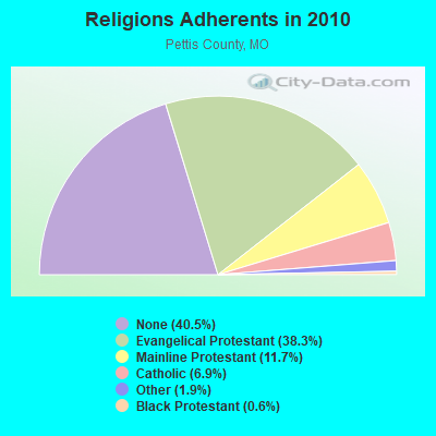
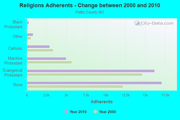
| Religion | Adherents | Congregations |
|---|---|---|
| Evangelical Protestant | 16,177 | 58 |
| Mainline Protestant | 4,957 | 23 |
| Catholic | 2,902 | 3 |
| Other | 799 | 5 |
| Black Protestant | 270 | 3 |
| None | 17,096 | - |
Food Environment Statistics:
| Pettis County: | 2.21 / 10,000 pop. |
| Missouri: | 1.88 / 10,000 pop. |
| Pettis County: | 0.25 / 10,000 pop. |
| Missouri: | 0.18 / 10,000 pop. |
| Pettis County: | 5.64 / 10,000 pop. |
| State: | 4.34 / 10,000 pop. |
| Pettis County: | 10.06 / 10,000 pop. |
| Missouri: | 7.37 / 10,000 pop. |
| Pettis County: | 8.8% |
| Missouri: | 8.8% |
| Here: | 28.2% |
| Missouri: | 29.6% |
| Pettis County: | 12.0% |
| Missouri: | 13.5% |
Health and Nutrition:
| Sedalia: | 48.0% |
| State: | 50.9% |
| Here: | 43.7% |
| Missouri: | 48.6% |
| Sedalia: | 28.8 |
| Missouri: | 28.7 |
| Sedalia: | 21.3% |
| Missouri: | 20.6% |
| This city: | 12.4% |
| Missouri: | 10.1% |
| Sedalia: | 6.8 |
| State: | 6.8 |
| This city: | 33.3% |
| State: | 34.3% |
| This city: | 54.2% |
| Missouri: | 57.5% |
| This city: | 77.0% |
| Missouri: | 79.3% |
More about Health and Nutrition of Sedalia, MO Residents
| Local government employment and payroll (March 2022) | |||||
| Function | Full-time employees | Monthly full-time payroll | Average yearly full-time wage | Part-time employees | Monthly part-time payroll |
|---|---|---|---|---|---|
| Police Protection - Officers | 44 | $191,611 | $52,258 | 0 | $0 |
| Firefighters | 43 | $186,024 | $51,914 | 0 | $0 |
| Other Government Administration | 24 | $49,831 | $24,916 | 11 | $6,678 |
| Other and Unallocable | 17 | $50,140 | $35,393 | 0 | $0 |
| Solid Waste Management | 17 | $53,156 | $37,522 | 0 | $0 |
| Water Supply | 15 | $47,844 | $38,275 | 0 | $0 |
| Streets and Highways | 14 | $46,159 | $39,565 | 0 | $0 |
| Sewerage | 12 | $86,034 | $86,034 | 0 | $0 |
| Parks and Recreation | 11 | $40,405 | $44,078 | 78 | $38,777 |
| Financial Administration | 8 | $31,574 | $47,361 | 0 | $0 |
| Local Libraries | 6 | $21,034 | $42,068 | 7 | $1,785 |
| Health | 6 | $14,581 | $29,162 | 0 | $0 |
| Police - Other | 6 | $20,606 | $41,212 | 2 | $545 |
| Airports | 2 | $8,281 | $49,686 | 1 | $1,395 |
| Totals for Government | 225 | $847,280 | $45,188 | 99 | $49,180 |
Sedalia government finances - Expenditure in 2021 (per resident):
- Construction - Hospitals: $7,162,000 ($326.33)
Parks and Recreation: $1,885,000 ($85.89)
Water Utilities: $1,437,000 ($65.48)
Local Fire Protection: $174,000 ($7.93)
Sewerage: $56,000 ($2.55)
Regular Highways: $33,000 ($1.50)
Air Transportation: $27,000 ($1.23)
Libraries: $2,000 ($0.09)
- Current Operations - Hospitals: $113,121,000 ($5154.28)
Sewerage: $5,118,000 ($233.20)
Police Protection: $3,767,000 ($171.64)
Water Utilities: $3,386,000 ($154.28)
Local Fire Protection: $2,816,000 ($128.31)
Regular Highways: $2,569,000 ($117.05)
Parks and Recreation: $1,952,000 ($88.94)
Solid Waste Management: $1,289,000 ($58.73)
Air Transportation: $634,000 ($28.89)
Central Staff Services: $597,000 ($27.20)
Protective Inspection and Regulation - Other: $478,000 ($21.78)
Libraries: $450,000 ($20.50)
Financial Administration: $423,000 ($19.27)
General Public Buildings: $334,000 ($15.22)
General - Other: $300,000 ($13.67)
Miscellaneous Commercial Activities - Other: $300,000 ($13.67)
Judicial and Legal Services: $164,000 ($7.47)
Health - Other: $92,000 ($4.19)
- General - Interest on Debt: $1,701,000 ($77.50)
- Intergovernmental to Local - Other - Financial Administration: $72,000 ($3.28)
- Other Capital Outlay - Water Utilities: $5,250,000 ($239.21)
Hospitals: $1,747,000 ($79.60)
Regular Highways: $247,000 ($11.25)
Solid Waste Management: $195,000 ($8.89)
Police Protection: $150,000 ($6.83)
Sewerage: $70,000 ($3.19)
Local Fire Protection: $40,000 ($1.82)
General Public Building: $30,000 ($1.37)
- Total Salaries and Wages: $50,160,000 ($2285.51)
- Water Utilities - Interest on Debt: $2,100,000 ($95.69)
Sedalia government finances - Revenue in 2021 (per resident):
- Charges - Hospital Public: $116,284,000 ($5298.40)
Sewerage: $5,631,000 ($256.57)
Solid Waste Management: $1,387,000 ($63.20)
Parks and Recreation: $438,000 ($19.96)
Air Transportation: $220,000 ($10.02)
Miscellaneous Commercial Activities: $200,000 ($9.11)
Other: $10,000 ($0.46)
- Federal Intergovernmental - Water Utilities: $22,000 ($1.00)
- Local Intergovernmental - Water Utilities: $2,000 ($0.09)
- Miscellaneous - General Revenue - Other: $510,000 ($23.24)
Interest Earnings: $290,000 ($13.21)
Fines and Forfeits: $108,000 ($4.92)
- Revenue - Water Utilities: $9,677,000 ($440.93)
- State Intergovernmental - Other: $3,050,000 ($138.97)
Highways: $827,000 ($37.68)
Water Utilities: $49,000 ($2.23)
- Tax - General Sales and Gross Receipts: $14,640,000 ($667.06)
Property: $2,834,000 ($129.13)
Public Utilities Sales: $2,575,000 ($117.33)
Other License: $584,000 ($26.61)
Occupation and Business License - Other: $96,000 ($4.37)
Tobacco Products Sales: $94,000 ($4.28)
Alcoholic Beverage License: $29,000 ($1.32)
Other Selective Sales: $5,000 ($0.23)
Sedalia government finances - Debt in 2021 (per resident):
- Long Term Debt - Beginning Outstanding - Unspecified Public Purpose: $78,868,000 ($3593.57)
Outstanding Unspecified Public Purpose: $73,436,000 ($3346.06)
Retired Unspecified Public Purpose: $5,432,000 ($247.51)
Sedalia government finances - Cash and Securities in 2021 (per resident):
- Other Funds - Cash and Securities: $85,703,000 ($3905.00)
- Sinking Funds - Cash and Securities: $998,000 ($45.47)
| Businesses in Sedalia, MO | ||||
| Name | Count | Name | Count | |
|---|---|---|---|---|
| ALDI | 1 | Little Caesars Pizza | 1 | |
| AT&T | 1 | Long John Silver's | 1 | |
| Ace Hardware | 1 | Lowe's | 1 | |
| Advance Auto Parts | 1 | MasterBrand Cabinets | 8 | |
| Applebee's | 1 | Maurices | 1 | |
| Arby's | 1 | McDonald's | 2 | |
| Ascend Collection | 1 | Menards | 1 | |
| AutoZone | 1 | New Balance | 2 | |
| Baskin-Robbins | 1 | Nike | 3 | |
| Best Western | 1 | Nissan | 1 | |
| Blockbuster | 1 | Papa John's Pizza | 1 | |
| Burger King | 1 | Payless | 1 | |
| Chevrolet | 1 | Penske | 1 | |
| Comfort Inn | 1 | RadioShack | 1 | |
| Curves | 1 | Ryan's Grill | 1 | |
| Dairy Queen | 1 | SONIC Drive-In | 2 | |
| Dennys | 1 | Sears | 1 | |
| Domino's Pizza | 1 | Sprint Nextel | 1 | |
| Econo Lodge | 1 | Staples | 1 | |
| FedEx | 4 | Starbucks | 1 | |
| Ford | 1 | Subway | 2 | |
| GNC | 1 | Super 8 | 1 | |
| GameStop | 1 | T-Mobile | 3 | |
| H&R Block | 1 | Taco Bell | 1 | |
| Hardee's | 2 | Toyota | 1 | |
| Holiday Inn | 1 | U-Haul | 3 | |
| JCPenney | 1 | U.S. Cellular | 1 | |
| Jimmy John's | 1 | UPS | 7 | |
| KFC | 1 | Vans | 1 | |
| Kmart | 1 | Walgreens | 1 | |
| Lane Furniture | 1 | Walmart | 1 | |
| LensCrafters | 1 | Wendy's | 1 | |
Strongest AM radio stations in Sedalia:
- KSIS (1050 AM; 1 kW; SEDALIA, MO)
- KDRO (1490 AM; 1 kW; SEDALIA, MO; Owner: MATHEWSON BROADCASTING COMPANY)
- WHB (810 AM; 50 kW; KANSAS CITY, MO; Owner: UNION BROADCASTING, INC.)
- KKHK (1250 AM; 25 kW; KANSAS CITY, KS)
- KRMS (1150 AM; 10 kW; OSAGE BEACH, MO; Owner: VIPER COMMUNICATIONS, INC)
- KCMO (710 AM; 10 kW; KANSAS CITY, MO; Owner: SUSQUEHANNA KANSAS CITY PARTNERSHIP)
- KXEN (1010 AM; 50 kW; FESTUS-ST. LOUIS, MO; Owner: BDJ RADIO ENTERPRISES, LLC)
- KWOS (950 AM; 5 kW; JEFFERSON CITY, MO; Owner: ZIMMER RADIO OF MID-MISSOURI, INC.)
- KMOX (1120 AM; 50 kW; ST. LOUIS, MO; Owner: INFINITY BROADCASTING OPERATIONS, INC.)
- KCCV (760 AM; daytime; 6 kW; OVERLAND PARK, KS; Owner: BOTT BROADCASTING COMPANY)
- KCTE (1510 AM; daytime; 10 kW; INDEPENDENCE, MO; Owner: UNION BROADCASTING, INC.)
- KCSP (610 AM; 5 kW; KANSAS CITY, MO; Owner: ENTERCOM KANSAS CITY LICENSE, LLC)
- KLIK (1240 AM; 5 kW; JEFFERSON CITY, MO; Owner: PREMIER RADIO GROUP)
Strongest FM radio stations in Sedalia:
- KSDL (92.1 FM; SEDALIA, MO; Owner: BICK BROADCASTING)
- KLRQ (96.1 FM; CLINTON, MO; Owner: B & F BROADCASTING, INC.)
- KPOW-FM (97.7 FM; LA MONTE, MO; Owner: SEDALIA INVESTMENT GROUP LLC)
- KCVK (107.7 FM; OTTERVILLE, MO; Owner: LAKE AREA EDUCATIONAL BROADCASTING FOUNDATION)
- KMMO-FM (102.9 FM; MARSHALL, MO; Owner: MISSOURI VALLEY BROADCASTING, INC.)
- K209AP (89.7 FM; SEDALIA, MO; Owner: LAKE AREA EDUCATIONAL B/CING FOUND.)
- K228CC (93.5 FM; SEDALIA, MO; Owner: J & J BROADCASTING)
- KTXY (106.9 FM; JEFFERSON CITY, MO; Owner: ZIMMER RADIO OF MID-MISSOURI, INC.)
- KXKX (105.7 FM; KNOB NOSTER, MO; Owner: BICK BROADCASTING COMPANY)
- KOQL (106.1 FM; ASHLAND, MO; Owner: MID-MISSOURI BROADCASTING, INC.)
- KMJK (107.3 FM; LEXINGTON, MO; Owner: ALLUR-KANSAS CITY, INC.)
- KMVC (91.7 FM; MARSHALL, MO; Owner: MISSOURI VALLEY COLLEGE)
- KCMQ (96.7 FM; COLUMBIA, MO; Owner: ZIMMER RADIO OF MID-MISSOURI, INC.)
- KWKJ (98.5 FM; WINDSOR, MO; Owner: D & H MEDIA, LLC)
- KCVQ (89.7 FM; KNOB NOSTER, MO; Owner: LAKE AREA EDUC. B/CASTING FOUNDATION)
TV broadcast stations around Sedalia:
- KMOS-TV (Channel 6; SEDALIA, MO; Owner: BOARD OF GOVERNORS OF CENTRAL MISSOURI STATE UNIVERSITY)
- KMIZ (Channel 17; COLUMBIA, MO; Owner: CHELSEY BROADCASTING COMPANY OF COLUMBIA, LLC)
- K32FH (Channel 32; WARRENSBURG, MO; Owner: ROGER E. HARDERS)
- K11OJ (Channel 11; SEDALIA, ETC., MO; Owner: MEL WHEELER INC.)
Medal of Honor Recipients
Medal of Honor Recipient born in Sedalia: James P. Fleming.
- National Bridge Inventory (NBI) Statistics
- 59Number of bridges
- 636ft / 194mTotal length
- $8,271,000Total costs
- 147,683Total average daily traffic
- 21,415Total average daily truck traffic
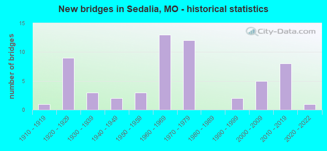
- New bridges - historical statistics
- 11910-1919
- 91920-1929
- 31930-1939
- 21940-1949
- 31950-1959
- 131960-1969
- 121970-1979
- 21990-1999
- 52000-2009
- 82010-2019
- 12020-2022
FCC Registered Antenna Towers: 259 (See the full list of FCC Registered Antenna Towers)
FCC Registered Commercial Land Mobile Towers: 9 (See the full list of FCC Registered Commercial Land Mobile Towers in Sedalia, MO)
FCC Registered Private Land Mobile Towers: 3 (See the full list of FCC Registered Private Land Mobile Towers)
FCC Registered Broadcast Land Mobile Towers: 40 (See the full list of FCC Registered Broadcast Land Mobile Towers)
FCC Registered Microwave Towers: 65 (See the full list of FCC Registered Microwave Towers in this town)
FCC Registered Paging Towers: 9 (See the full list of FCC Registered Paging Towers)
FCC Registered Maritime Coast & Aviation Ground Towers: 2 (See the full list of FCC Registered Maritime Coast & Aviation Ground Towers)
FCC Registered Amateur Radio Licenses: 179 (See the full list of FCC Registered Amateur Radio Licenses in Sedalia)
FAA Registered Aircraft Manufacturers and Dealers: 1 (See the full list of FAA Registered Manufacturers and Dealers in Sedalia)
FAA Registered Aircraft: 25 (See the full list of FAA Registered Aircraft)
2002 - 2018 National Fire Incident Reporting System (NFIRS) incidents
- Fire incident types reported to NFIRS in Sedalia, MO
- 1,37245.3%Outside Fires
- 1,07335.4%Structure Fires
- 43714.4%Mobile Property/Vehicle Fires
- 1464.8%Other
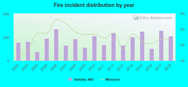 Based on the data from the years 2002 - 2018 the average number of fires per year is 178. The highest number of reported fires - 269 took place in 2006, and the least - 76 in 2004. The data has a rising trend.
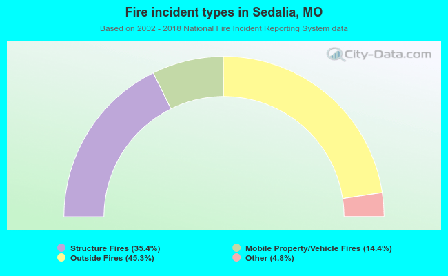 When looking into fire subcategories, the most incidents belonged to: Outside Fires (45.3%), and Structure Fires (35.4%).
Fire-safe hotels and motels in Sedalia, Missouri:
- Truman Inn & Suites/Econo Lodge, 3501 W Broadway, Sedalia, Missouri 65301 , Phone: (660) 826-8400, Fax: (660) 826-1230
- Super 8 Motel Sedalia, 3402 W Broadway, Sedalia, Missouri 65301 , Phone: (660) 827-5890, Fax: (660) 827-3061
- Best Western State Fair Inn, 3120 S Limit Ave, Sedalia, Missouri 65301 , Phone: (660) 826-6100, Fax: (660) 827-3850
- Comfort Inn Sedalia Station, 3600 W Broadway, Sedalia, Missouri 65301 , Phone: (660) 829-5050, Fax: (660) 829-5150
- Holiday Inn Express Hotel & Suite, 4001 W Broadway, Sedalia, Missouri 65301 , Phone: (660) 826-4000, Fax: (660) 826-4001
- Hampton Inn Sedalia, 3909 W 9th St, Sedalia, Missouri 65301 , Phone: (660) 951-1163, Fax: (660) 951-1164
| Most common first names in Sedalia, MO among deceased individuals | ||
| Name | Count | Lived (average) |
|---|---|---|
| Mary | 339 | 79.8 years |
| William | 294 | 76.0 years |
| John | 278 | 75.2 years |
| James | 243 | 74.3 years |
| Charles | 189 | 75.6 years |
| Robert | 188 | 71.7 years |
| George | 163 | 77.7 years |
| Helen | 125 | 78.9 years |
| Anna | 107 | 83.2 years |
| Margaret | 107 | 79.4 years |
| Most common last names in Sedalia, MO among deceased individuals | ||
| Last name | Count | Lived (average) |
|---|---|---|
| Smith | 144 | 75.7 years |
| Williams | 109 | 76.8 years |
| Johnson | 86 | 79.1 years |
| Miller | 83 | 75.8 years |
| Jones | 79 | 73.4 years |
| Brown | 66 | 80.6 years |
| Thomas | 57 | 77.3 years |
| Davis | 53 | 77.9 years |
| Taylor | 48 | 75.4 years |
| Anderson | 45 | 76.4 years |
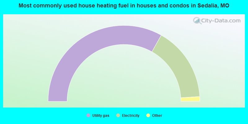
- 66.4%Utility gas
- 31.7%Electricity
- 1.1%Bottled, tank, or LP gas
- 0.9%Wood
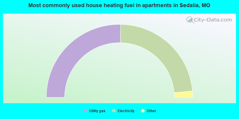
- 50.5%Utility gas
- 46.8%Electricity
- 1.6%No fuel used
- 1.0%Wood
Sedalia compared to Missouri state average:
- Median house value below state average.
- Unemployed percentage below state average.
- Black race population percentage below state average.
- Hispanic race population percentage significantly above state average.
- Foreign-born population percentage above state average.
- Length of stay since moving in above state average.
Sedalia on our top lists:
- #39 on the list of "Top 101 cities with the biggest local government total salary and wages expenses per resident (population 10,000+)"
- #87 on the list of "Top 101 cities with the smallest racial income disparities between White and Black householders (with at least 200 householders)"

|
|
Total of 17 patent applications in 2008-2024.