Silverpeak, Nevada
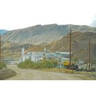
Silverpeak: Silver Peak, Nevada Chemetall lithium processing plant

Silverpeak: the perfectly paved road to Silver Peak, Nevada

Silverpeak: Silver Peak, Nevada
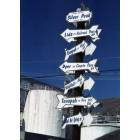
Silverpeak: Mileage Sign, Silver Peak NEVADA
- add
your
Submit your own pictures of this place and show them to the world
- OSM Map
- General Map
- Google Map
- MSN Map

| Males: 209 | |
| Females: 167 |
| Median resident age: | 41.7 years |
| Nevada median age: | 35.0 years |
Zip code: 89010
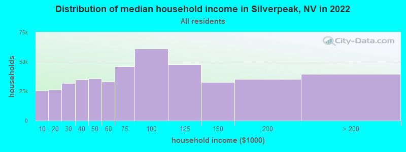
| Silverpeak: | $41,375 |
| NV: | $72,333 |
Estimated per capita income in 2022: $30,020 (it was $17,811 in 2000)
Silverpeak CCD income, earnings, and wages data
Estimated median house or condo value in 2022: $103,796 (it was $44,300 in 2000)
| Silverpeak: | $103,796 |
| NV: | $434,700 |
Detailed information about poverty and poor residents in Silverpeak, NV


- 38472.3%White alone
- 7614.3%Hispanic
- 397.3%American Indian alone
- 315.8%Two or more races
- 10.2%Native Hawaiian and Other
Pacific Islander alone
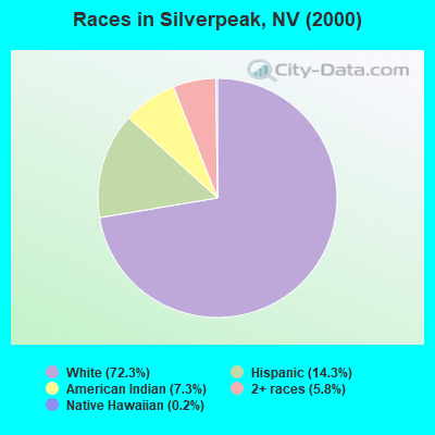
Races in Silverpeak detailed stats: ancestries, foreign born residents, place of birth
 Recent articles from our blog. Our writers, many of them Ph.D. graduates or candidates, create easy-to-read articles on a wide variety of topics.
Current Local Time: PST time zone
Land area: 2064.3 square miles.
Population density: 0.2 people per square mile (very low).

| Silverpeak CCD: | 1.6% ($688) |
| Nevada: | 0.9% ($1,187) |
Nearest city with pop. 50,000+: Clovis, CA  (130.9 miles , pop. 68,468).
Nearest city with pop. 200,000+: Fresno, CA (136.8 miles , pop. 427,652).
Nearest city with pop. 1,000,000+: Los Angeles, CA (270.8 miles , pop. 3,694,820).
Nearest cities:
), ), ), ), )Latitude: 37.97 N, Longitude: 117.81 W
Area code commonly used in this area: 775

| Here: | 4.0% |
| Nevada: | 5.0% |
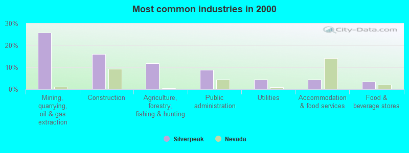
- Mining, quarrying, oil & gas extraction (25.8%)
- Construction (16.2%)
- Agriculture, forestry, fishing & hunting (11.8%)
- Public administration (8.7%)
- Utilities (4.4%)
- Accommodation & food services (4.4%)
- Food & beverage stores (3.5%)
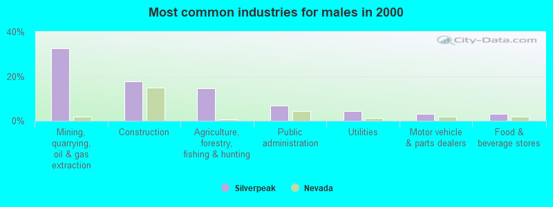
- Mining, quarrying, oil & gas extraction (32.5%)
- Construction (17.8%)
- Agriculture, forestry, fishing & hunting (14.7%)
- Public administration (6.7%)
- Utilities (4.3%)
- Motor vehicle & parts dealers (3.1%)
- Food & beverage stores (3.1%)
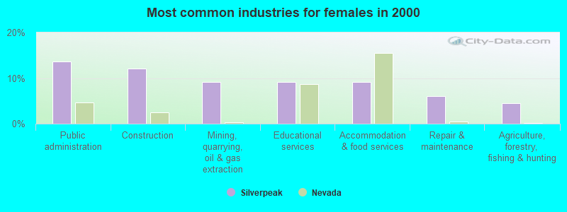
- Public administration (13.6%)
- Construction (12.1%)
- Mining, quarrying, oil & gas extraction (9.1%)
- Educational services (9.1%)
- Accommodation & food services (9.1%)
- Repair & maintenance (6.1%)
- Agriculture, forestry, fishing & hunting (4.5%)
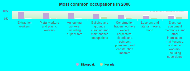
- Extraction workers (9.2%)
- Metal workers and plastic workers (7.4%)
- Agricultural workers, including supervisors (7.4%)
- Building and grounds cleaning and maintenance occupations (6.1%)
- Construction traders workers except carpenters, electricians, painters, plumbers, and construction laborers (5.2%)
- Laborers and material movers, hand (4.4%)
- Electrical equipment mechanics and other installation, maintenance, and repair workers, including supervisors (4.4%)
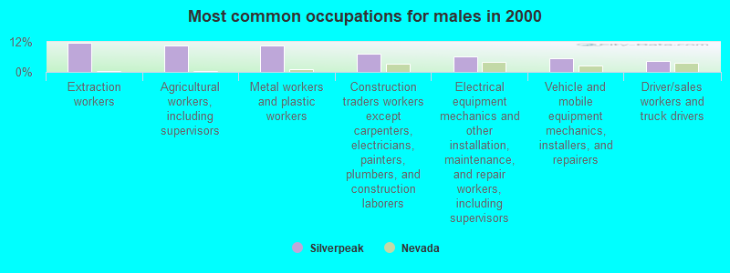
- Extraction workers (11.7%)
- Agricultural workers, including supervisors (10.4%)
- Metal workers and plastic workers (10.4%)
- Construction traders workers except carpenters, electricians, painters, plumbers, and construction laborers (7.4%)
- Electrical equipment mechanics and other installation, maintenance, and repair workers, including supervisors (6.1%)
- Vehicle and mobile equipment mechanics, installers, and repairers (5.5%)
- Driver/sales workers and truck drivers (4.3%)
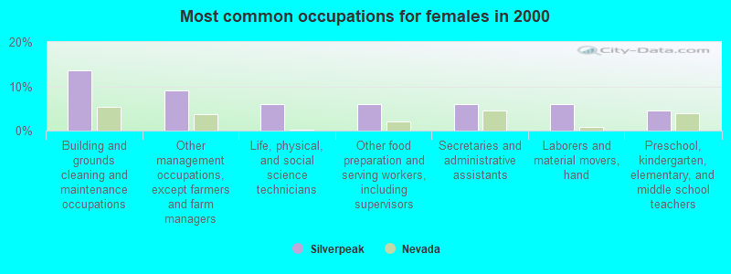
- Building and grounds cleaning and maintenance occupations (13.6%)
- Other management occupations, except farmers and farm managers (9.1%)
- Life, physical, and social science technicians (6.1%)
- Other food preparation and serving workers, including supervisors (6.1%)
- Secretaries and administrative assistants (6.1%)
- Laborers and material movers, hand (6.1%)
- Preschool, kindergarten, elementary, and middle school teachers (4.5%)
Average climate in Silverpeak, Nevada
Based on data reported by over 4,000 weather stations


Earthquake activity:
Silverpeak-area historical earthquake activity is significantly above Nevada state average. It is 7755% greater than the overall U.S. average.On 12/21/1932 at 06:10:09, a magnitude 7.2 (7.2 UK, Class: Major, Intensity: VIII - XII) earthquake occurred 39.9 miles away from Silverpeak center
On 10/3/1915 at 06:52:48, a magnitude 7.6 (7.6 UK) earthquake occurred 175.4 miles away from Silverpeak center
On 7/21/1952 at 11:52:14, a magnitude 7.7 (7.7 UK) earthquake occurred 216.2 miles away from the city center, causing $50,000,000 total damage
On 4/18/1906 at 13:12:21, a magnitude 7.9 (7.9 UK) earthquake occurred 283.0 miles away from the city center, causing $524,000,000 total damage
On 12/16/1954 at 11:07:12, a magnitude 7.0 (7.0 UK) earthquake occurred 85.4 miles away from the city center
On 6/28/1992 at 11:57:34, a magnitude 7.6 (6.2 MB, 7.6 MS, 7.3 MW, Depth: 0.7 mi) earthquake occurred 271.7 miles away from the city center, causing 3 deaths (1 shaking deaths, 2 other deaths) and 400 injuries, causing $100,000,000 total damage and $40,000,000 insured losses
Magnitude types: body-wave magnitude (MB), surface-wave magnitude (MS), moment magnitude (MW)
Natural disasters:
The number of natural disasters in Esmeralda County (2) is a lot smaller than the US average (15).Emergencies Declared: 1
Causes of natural disasters: Hurricane: 1, Other: 1 (Note: some incidents may be assigned to more than one category).
Colleges/universities with over 2000 students nearest to Silverpeak:
- Reedley College (about 132 miles; Reedley, CA; Full-time enrollment: 8,144)
- Institute of Technology Inc (about 132 miles; Clovis, CA; FT enrollment: 2,483)
- California State University-Fresno (about 134 miles; Fresno, CA; FT enrollment: 18,993)
- University of Phoenix-Central Valley Campus (about 134 miles; Fresno, CA; FT enrollment: 2,109)
- Heald College-Fresno (about 136 miles; Fresno, CA; FT enrollment: 2,199)
- Western Nevada College (about 137 miles; Carson City, NV; FT enrollment: 2,338)
- Fresno Pacific University (about 137 miles; Fresno, CA; FT enrollment: 3,083)
Public elementary/middle school in Silverpeak:
- SILVER PEAK ELEMENTARY SCHOOL (Location: 500 GALENA ST., Grades: KG-8)
Points of interest:
Notable locations in Silverpeak: Bar Double 9 Ranch (A), Swiftwater (B), Millers Rest Area (C), Gates Mill (D), McGeer (E), Palmetto Electric Substation (F), Coaldale Substation (G), Gilbert Junction (H), Crown Mill (I), Esmeralda County Yard (J), Candelaria Pipeline (K), Circle L Ranch (L), Fish Lake Valley Community Hall (M), McAfee Ranch (N), Dunham Mill Site (O), Dyer Ranch (P), Winkonley Ranch (Q), Wood Yard (R), Boundary Peak Trailhead (S), Silver Peak and Red Mountain Gold (T). Display/hide their locations on the map
Lakes, reservoirs, and swamps: Millers Pond (A), Dry Lake (B), Fish Lake (C), Silver Peak Pond (D), Silver Peak Marsh (E). Display/hide their locations on the map
Creeks: Davis Creek (A), Peavine Creek (B), Pinchot Creek (C), Trail Creek (D), Rock Creek (E), Leidy Creek (F), Dry Creek (G), South Fork Chatworth Creek (H), North Fork Chatworth Creek (I). Display/hide their locations on the map
| This place: | 2.2 people |
| Nevada: | 2.6 people |
| This place: | 61.9% |
| Whole state: | 65.3% |
| This place: | 6.0% |
| Whole state: | 8.7% |
Likely homosexual households (counted as self-reported same-sex unmarried-partner households)
- Lesbian couples: 0.5% of all households
- Gay men: 0.0% of all households
| This place: | 18.0% |
| Whole state: | 10.5% |
| This place: | 7.7% |
| Whole state: | 4.9% |
For population 15 years and over in Silverpeak:
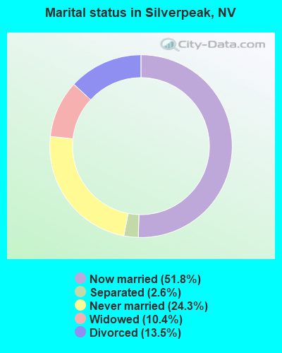
- Never married: 24.3%
- Now married: 51.8%
- Separated: 2.6%
- Widowed: 10.4%
- Divorced: 13.5%
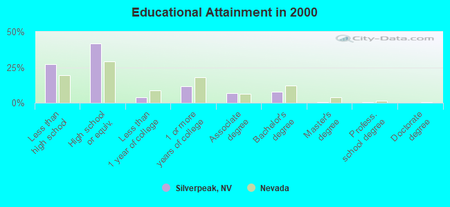
For population 25 years and over in Silverpeak:
- High school or higher: 72.8%
- Bachelor's degree or higher: 9.0%
- Graduate or professional degree: 1.2%
- Unemployed: 3.4%
- Mean travel time to work (commute): 22.7 minutes
| Here: | 11.8 |
| Nevada average: | 11.9 |
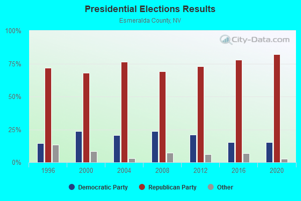


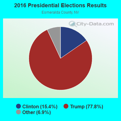
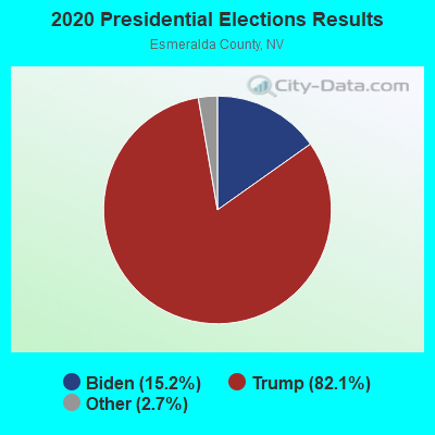
Graphs represent county-level data. Detailed 2008 Election Results
Religion statistics for Silverpeak, NV (based on Esmeralda County data)
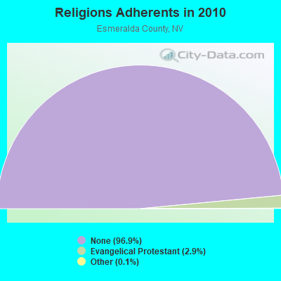
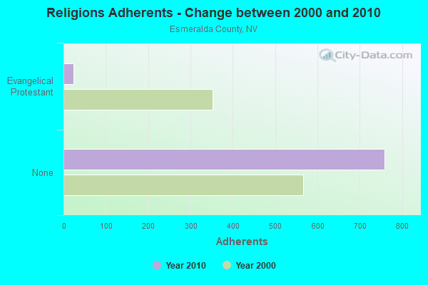
| Religion | Adherents | Congregations |
|---|---|---|
| Evangelical Protestant | 23 | 1 |
| Other | 1 | - |
| Mainline Protestant | - | - |
| None | 759 | - |
Food Environment Statistics:
| This county: | 10.8% |
| State: | 8.2% |
| Esmeralda County: | 25.6% |
| Nevada: | 24.5% |
Strongest AM radio stations in Silverpeak:
- KMJ (580 AM; 50 kW; FRESNO, CA; Owner: INFINITY RADIO OPERATIONS INC.)
- KWRU (940 AM; 50 kW; FRESNO, CA)
- KKOH (780 AM; 50 kW; RENO, NV; Owner: CITADEL BROADCASTING COMPANY)
- KCBC (770 AM; 50 kW; RIVERBANK, CA; Owner: KIERTRON, INC.)
- KDWN (720 AM; 50 kW; LAS VEGAS, NV; Owner: RADIO NEVADA CORP.)
- KXNT (840 AM; 50 kW; NORTH LAS VEGAS, NV; Owner: INFINITY RADIO OPERATIONS INC.)
- KHTK (1140 AM; 50 kW; SACRAMENTO, CA; Owner: INFINITY RADIO SUBSIDIARY OPERATIONS INC.)
- KERI (1180 AM; 50 kW; WASCO-GREENACRES, CA; Owner: KWSO, INC.)
- KNBR (680 AM; 50 kW; SAN FRANCISCO, CA; Owner: KNBR LICO, INC.)
- KLAC (570 AM; 50 kW; LOS ANGELES, CA; Owner: AMFM RADIO LICENSES, L.L.C.)
- KGDP (660 AM; 50 kW; ORCUTT, CA; Owner: RADIO REPRESENTATIVES, INC.)
- KGO (810 AM; 50 kW; SAN FRANCISCO, CA; Owner: KGO-AM RADIO, INC.)
- KSTE (650 AM; 25 kW; RANCHO CORDOVA, CA; Owner: AMFM RADIO LICENSES, L.L.C.)
Strongest FM radio stations in Silverpeak:
- KRHV (93.3 FM; BIG PINE, CA; Owner: DAVID A. AND MARYANN M. DIGERNESS)
- KIBS (100.7 FM; BISHOP, CA; Owner: GREAT COUNTRY BROADCASTING, INC.)
- K208BS (89.5 FM; BISHOP, CA; Owner: WESTERN INSPIRATIONAL B/CASTERS, INC)
- KWTW (88.5 FM; BISHOP, CA; Owner: LIVING PROOF, INC.)
- KTPH (91.7 FM; TONOPAH, NV; Owner: NEVADA PUBLIC RADIO CORPORATION)
- K214CJ (90.7 FM; TONOPAH, NV; Owner: WESTERN INSPIRATIONAL BROADCASTERS, INC)
- KDAY (92.5 FM; INDEPENDENCE, CA; Owner: MS. BENETT KESSLER)
- K205ET (88.9 FM; BIG PINE, ETC., CA; Owner: WESTERN INSPIRATIONAL BROADCASTERS, INC)
- KHWK (92.7 FM; TONOPAH, NV; Owner: DONALD W. KAMINSKI, JR.)
- K221DR (92.1 FM; ROUND MOUNTAIN, NV; Owner: SMOKY VALLEY TELEVISION DISTRICT)
FCC Registered Microwave Towers:
1- COALDALE, Columbus Repeater (Lat: 38.160806 Lon: -118.003611), Type: Mast, Structure height: 15.2 m, Call Sign: WQKM456,
Assigned Frequencies: 6226.89 MHz, 6197.24 MHz, 6226.89 MHz, 6197.24 MHz, 6226.89 MHz, 6197.24 MHz, 6226.89 MHz, 6197.24 MHz, 11405.0 MHz, 11405.0 MHz... (+34 more), Grant Date: 08/20/2019, Expiration Date: 07/14/2029, Certifier: Ryan Levine, Registrant: Wilkinson Barker Knauer, LLP, 1800 M Street, Nw, Suite 800n, Washington, DC 20036, Phone: (202) 783-4141, Fax: (202) 783-5851, Email:
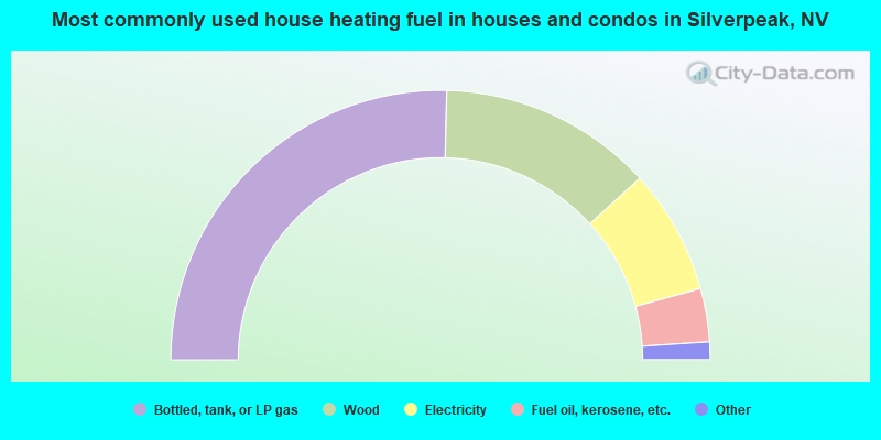
- 50.7%Bottled, tank, or LP gas
- 25.7%Wood
- 15.0%Electricity
- 6.4%Fuel oil, kerosene, etc.
- 1.4%Solar energy
- 0.7%Utility gas
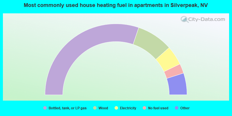
- 60.4%Bottled, tank, or LP gas
- 16.5%Wood
- 8.8%Electricity
- 4.4%No fuel used
- 3.3%Utility gas
- 3.3%Fuel oil, kerosene, etc.
- 3.3%Other fuel
Silverpeak compared to Nevada state average:
- Median household income below state average.
- Median house value significantly below state average.
- Unemployed percentage significantly below state average.
- Black race population percentage significantly below state average.
- Hispanic race population percentage below state average.
- Foreign-born population percentage significantly below state average.
- Renting percentage below state average.
- Length of stay since moving in significantly above state average.
- Number of rooms per house significantly below state average.
- House age significantly below state average.
- Number of college students significantly below state average.
- Percentage of population with a bachelor's degree or higher below state average.
Silverpeak on our top lists:
- #46 on the list of "Top 100 cities with largest land areas"
- #6 on the list of "Top 101 counties with highest percentage of residents voting for 3rd party candidates in the 2012 Presidential Election"
- #99 on the list of "Top 101 counties with the highest percentage of residents relocating from other counties between 2010 and 2011"
- #100 on the list of "Top 101 counties with the highest percentage of residents relocating to other counties in 2011"