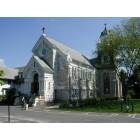
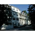
Stockbridge, Massachusetts
Submit your own pictures of this town and show them to the world
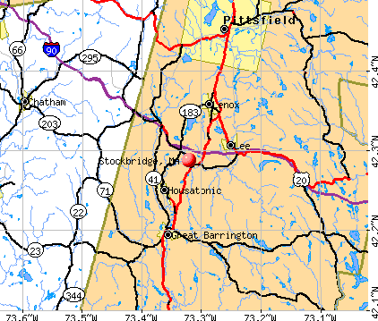
- OSM Map
- General Map
- Google Map
- MSN Map
Population change since 2000: -14.5%
 |
| Males: 915 | |
| Females: 1,032 |
| Median resident age: | 53.6 years |
| Massachusetts median age: | 39.2 years |
Zip codes: 01262.
| Stockbridge: | $92,268 |
| MA: | $94,488 |
Estimated per capita income in 2022: $72,895 (it was $32,499 in 2000)
Stockbridge town income, earnings, and wages data
Estimated median house or condo value in 2022: $631,645 (it was $236,200 in 2000)
| Stockbridge: | $631,645 |
| MA: | $534,700 |
Mean prices in 2022: all housing units: $357,971; detached houses: $376,086; townhouses or other attached units: $341,816; in 2-unit structures: $250,940; in 3-to-4-unit structures: $400,871; in 5-or-more-unit structures: $281,990; mobile homes: $80,872
Detailed information about poverty and poor residents in Stockbridge, MA


- 1,82693.8%White alone
- 593.0%Hispanic
- 191.0%Asian alone
- 180.9%Black alone
- 160.8%Two or more races
- 80.4%Other race alone
- 10.05%American Indian alone
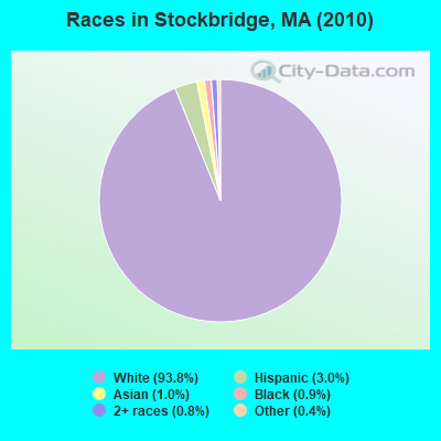
Races in Stockbridge detailed stats: ancestries, foreign born residents, place of birth
According to our research of Massachusetts and other state lists, there was 1 registered sex offender living in Stockbridge, Massachusetts as of April 26, 2024.
The ratio of all residents to sex offenders in Stockbridge is 1,947 to 1.
The ratio of registered sex offenders to all residents in this city is lower than the state average.
Type |
2009 |
2010 |
2011 |
2012 |
2013 |
2014 |
2015 |
2016 |
2017 |
2018 |
2019 |
2020 |
2021 |
2022 |
|---|---|---|---|---|---|---|---|---|---|---|---|---|---|---|
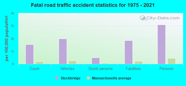
| Murders (per 100,000) | 0 (0.0) | 0 (0.0) | 0 (0.0) | 0 (0.0) | 0 (0.0) | 0 (0.0) | 0 (0.0) | 0 (0.0) | 0 (0.0) | 0 (0.0) | 0 (0.0) | 0 (0.0) | 0 (0.0) | 0 (0.0) |
| Rapes (per 100,000) | 0 (0.0) | 1 (51.4) | 2 (102.1) | 1 (51.2) | 0 (0.0) | 0 (0.0) | 1 (51.3) | 2 (103.3) | 3 (156.3) | 1 (52.6) | 0 (0.0) | 0 (0.0) | 0 (0.0) | 1 (50.1) |
| Robberies (per 100,000) | 0 (0.0) | 1 (51.4) | 0 (0.0) | 0 (0.0) | 0 (0.0) | 1 (50.8) | 0 (0.0) | 0 (0.0) | 0 (0.0) | 0 (0.0) | 0 (0.0) | 0 (0.0) | 0 (0.0) | 0 (0.0) |
| Assaults (per 100,000) | 4 (177.7) | 5 (256.8) | 4 (204.2) | 5 (256.0) | 4 (203.5) | 4 (203.4) | 5 (256.3) | 2 (103.3) | 2 (104.2) | 2 (105.3) | 1 (52.7) | 2 (106.2) | 1 (53.3) | 4 (200.3) |
| Burglaries (per 100,000) | 68 (3,021) | 58 (2,979) | 49 (2,501) | 23 (1,178) | 15 (763.0) | 11 (559.2) | 16 (820.1) | 8 (413.2) | 12 (625.3) | 5 (263.2) | 4 (210.7) | 4 (212.3) | 5 (266.4) | 2 (100.2) |
| Thefts (per 100,000) | 48 (2,132) | 56 (2,876) | 40 (2,042) | 29 (1,485) | 20 (1,017) | 21 (1,068) | 28 (1,435) | 16 (826.4) | 25 (1,303) | 20 (1,053) | 19 (1,001) | 19 (1,008) | 13 (692.6) | 12 (600.9) |
| Auto thefts (per 100,000) | 2 (88.8) | 2 (102.7) | 2 (102.1) | 2 (102.4) | 0 (0.0) | 1 (50.8) | 0 (0.0) | 1 (51.7) | 1 (52.1) | 1 (52.6) | 1 (52.7) | 0 (0.0) | 2 (106.6) | 1 (50.1) |
| Arson (per 100,000) | 0 (0.0) | 0 (0.0) | 0 (0.0) | 0 (0.0) | 0 (0.0) | 0 (0.0) | 0 (0.0) | 0 (0.0) | 0 (0.0) | 0 (0.0) | 0 (0.0) | 0 (0.0) | 0 (0.0) | 0 (0.0) |
| City-Data.com crime index | 339.4 | 439.7 | 387.4 | 242.2 | 134.8 | 141.8 | 207.1 | 169.4 | 246.0 | 127.9 | 69.5 | 76.4 | 65.5 | 115.2 |
The City-Data.com crime index weighs serious crimes and violent crimes more heavily. Higher means more crime, U.S. average is 246.1. It adjusts for the number of visitors and daily workers commuting into cities.
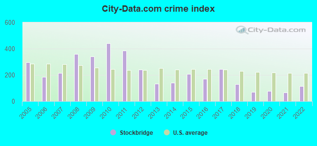
Crime rate in Stockbridge detailed stats: murders, rapes, robberies, assaults, burglaries, thefts, arson
Full-time law enforcement employees in 2021, including police officers: 8 (7 officers - 6 male; 1 female).
| Officers per 1,000 residents here: | 3.73 |
| Massachusetts average: | 2.53 |
 Recent articles from our blog. Our writers, many of them Ph.D. graduates or candidates, create easy-to-read articles on a wide variety of topics.

 | Hillbilly Massachusetts (103 replies) |
| 1 day trip across MA - what route for iconic scenery? (43 replies) |
| Is it possible to escape hunters, ATVs and noise in a rural area? (278 replies) |
| Great Barrington vs West Stockbridge (12 replies) |
| Best Berkshire's weekend (26 replies) |
| Berkshires vs. Cape Cod for late career move? (89 replies) |
Latest news from Stockbridge, MA collected exclusively by city-data.com from local newspapers, TV, and radio stations
Stockbridge, MA City Guides:
Ancestries: English (18.3%), Irish (16.5%), German (10.8%), Italian (9.5%), Polish (6.8%), French (5.8%).
Current Local Time: EST time zone
Incorporated in 1739
Elevation: 842 feet
Land area: 22.9 square miles.
Population density: 85 people per square mile (very low).
191 residents are foreign born (4.1% Europe, 2.5% Latin America, 1.1% North America).
| This town: | 8.4% |
| Massachusetts: | 12.2% |
| Stockbridge town: | 0.8% ($1,797) |
| Massachusetts: | 1.3% ($2,336) |
Nearest city with pop. 50,000+: Albany, NY  (34.1 miles , pop. 95,658).
Nearest city with pop. 200,000+: Bronx, NY (104.6 miles , pop. 1,332,650).
Nearest cities:
), ), ), ), Latitude: 42.30 N, Longitude: 73.32 W
Area code: 413

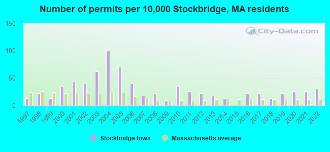
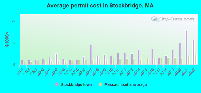
Single-family new house construction building permits:
- 2022: 7 buildings, average cost: $1,131,400
- 2021: 6 buildings, average cost: $1,542,600
- 2020: 6 buildings, average cost: $999,800
- 2019: 5 buildings, average cost: $677,600
- 2018: 3 buildings, average cost: $414,200
- 2017: 5 buildings, average cost: $306,900
- 2016: 5 buildings, average cost: $722,300
- 2014: 3 buildings, average cost: $699,800
- 2013: 4 buildings, average cost: $509,700
- 2012: 5 buildings, average cost: $538,300
- 2011: 6 buildings, average cost: $543,100
- 2010: 8 buildings, average cost: $396,600
- 2009: 2 buildings, average cost: $463,500
- 2008: 5 buildings, average cost: $393,900
- 2007: 4 buildings, average cost: $916,800
- 2006: 9 buildings, average cost: $367,100
- 2005: 16 buildings, average cost: $211,300
- 2004: 23 buildings, average cost: $210,800
- 2003: 14 buildings, average cost: $273,500
- 2002: 9 buildings, average cost: $514,400
- 2001: 10 buildings, average cost: $349,300
- 2000: 8 buildings, average cost: $262,600
- 1999: 3 buildings, average cost: $247,200
- 1998: 5 buildings, average cost: $247,200
- 1997: 3 buildings, average cost: $247,200
| Here: | 4.0% |
| Massachusetts: | 3.5% |
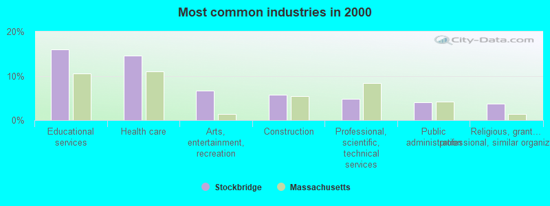
- Educational services (15.9%)
- Health care (14.6%)
- Arts, entertainment, recreation (6.7%)
- Construction (5.8%)
- Professional, scientific, technical services (4.8%)
- Public administration (4.0%)
- Religious, grantmaking, civic, professional, similar organizations (3.7%)
- Educational services (13.3%)
- Construction (10.7%)
- Health care (9.7%)
- Arts, entertainment, recreation (6.3%)
- Professional, scientific, technical services (5.0%)
- Public administration (4.2%)
- Accommodation & food services (3.3%)
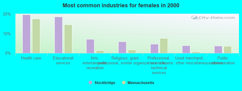
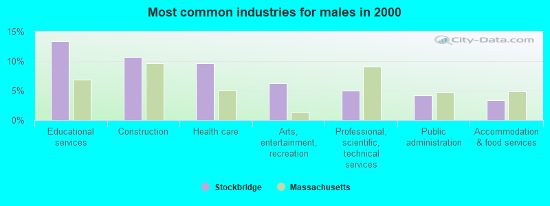
- Health care (19.7%)
- Educational services (18.5%)
- Arts, entertainment, recreation (7.1%)
- Religious, grantmaking, civic, professional, similar organizations (6.0%)
- Professional, scientific, technical services (4.6%)
- Used merchandise, gift, novelty, souvenir, other miscellaneous stores (3.9%)
- Public administration (3.7%)
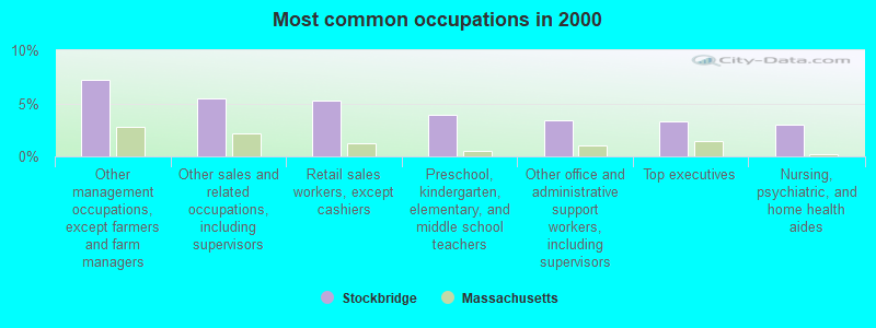
- Other management occupations, except farmers and farm managers (7.2%)
- Other sales and related occupations, including supervisors (5.5%)
- Retail sales workers, except cashiers (5.3%)
- Preschool, kindergarten, elementary, and middle school teachers (3.9%)
- Other office and administrative support workers, including supervisors (3.4%)
- Top executives (3.3%)
- Nursing, psychiatric, and home health aides (3.0%)
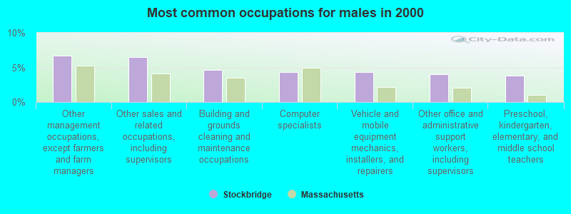
- Other management occupations, except farmers and farm managers (6.7%)
- Other sales and related occupations, including supervisors (6.5%)
- Building and grounds cleaning and maintenance occupations (4.7%)
- Computer specialists (4.3%)
- Vehicle and mobile equipment mechanics, installers, and repairers (4.3%)
- Other office and administrative support workers, including supervisors (4.0%)
- Preschool, kindergarten, elementary, and middle school teachers (3.8%)
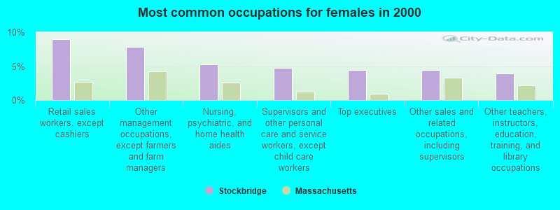
- Retail sales workers, except cashiers (9.0%)
- Other management occupations, except farmers and farm managers (7.8%)
- Nursing, psychiatric, and home health aides (5.3%)
- Supervisors and other personal care and service workers, except child care workers (4.8%)
- Top executives (4.4%)
- Other sales and related occupations, including supervisors (4.4%)
- Other teachers, instructors, education, training, and library occupations (3.9%)
Average climate in Stockbridge, Massachusetts
Based on data reported by over 4,000 weather stations


(lower is better)
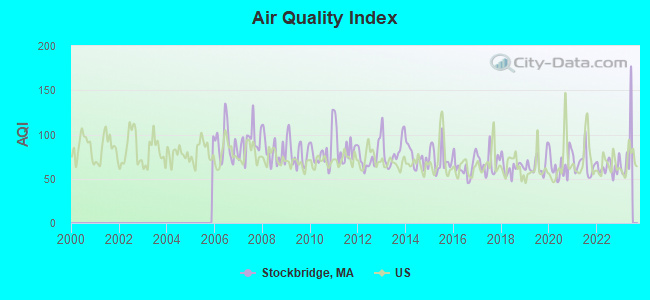
Air Quality Index (AQI) level in 2022 was 63.2. This is about average.
| City: | 63.2 |
| U.S.: | 72.6 |
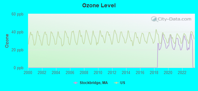
Ozone [ppb] level in 2022 was 27.5. This is better than average. Closest monitor was 11.3 miles away from the city center.
| City: | 27.5 |
| U.S.: | 33.3 |
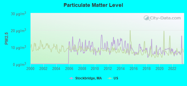
Particulate Matter (PM2.5) [µg/m3] level in 2022 was 6.76. This is about average. Closest monitor was 10.7 miles away from the city center.
| City: | 6.76 |
| U.S.: | 8.11 |
Tornado activity:
Stockbridge-area historical tornado activity is slightly above Massachusetts state average. It is 19% smaller than the overall U.S. average.
On 8/28/1973, a category F4 (max. wind speeds 207-260 mph) tornado 3.7 miles away from the Stockbridge town center killed 4 people and injured 36 people and caused between $5,000,000 and $50,000,000 in damages.
On 5/29/1995, a category F4 tornado 8.9 miles away from the town center killed 3 people and injured 24 people and caused between $5,000,000 and $50,000,000 in damages.
Earthquake activity:
Stockbridge-area historical earthquake activity is significantly above Massachusetts state average. It is 69% smaller than the overall U.S. average.On 10/7/1983 at 10:18:46, a magnitude 5.3 (5.1 MB, 5.3 LG, 5.1 ML, Class: Moderate, Intensity: VI - VII) earthquake occurred 125.3 miles away from Stockbridge center
On 4/20/2002 at 10:50:47, a magnitude 5.3 (5.3 ML, Depth: 3.0 mi) earthquake occurred 154.1 miles away from Stockbridge center
On 4/20/2002 at 10:50:47, a magnitude 5.2 (5.2 MB, 4.2 MS, 5.2 MW, 5.0 MW) earthquake occurred 152.5 miles away from Stockbridge center
On 1/19/1982 at 00:14:42, a magnitude 4.7 (4.5 MB, 4.7 MD, 4.5 LG, Class: Light, Intensity: IV - V) earthquake occurred 120.3 miles away from Stockbridge center
On 10/16/2012 at 23:12:25, a magnitude 4.7 (4.7 ML, Depth: 10.0 mi) earthquake occurred 162.0 miles away from Stockbridge center
On 8/23/2011 at 17:51:04, a magnitude 5.8 (5.8 MW, Depth: 3.7 mi) earthquake occurred 389.6 miles away from the city center
Magnitude types: regional Lg-wave magnitude (LG), body-wave magnitude (MB), duration magnitude (MD), local magnitude (ML), surface-wave magnitude (MS), moment magnitude (MW)
Natural disasters:
The number of natural disasters in Berkshire County (21) is greater than the US average (15).Major Disasters (Presidential) Declared: 10
Emergencies Declared: 10
Causes of natural disasters: Floods: 5, Snowstorms: 5, Storms: 5, Hurricanes: 4, Winter Storms: 4, Blizzards: 2, Snows: 2, Snowfall: 1, Tropical Storm: 1, Wind: 1, Other: 1 (Note: some incidents may be assigned to more than one category).
Hospitals and medical centers near Stockbridge:
- KINDRED NURSING AND REHABILITATION-LAUREL LAKE (Nursing Home, about 4 miles away; LEE, MA)
- LEE REGIONAL VNA INC. (Home Health Center, about 4 miles away; LEE, MA)
- NURSING CARE CENTER AT KIMBALL (Nursing Home, about 5 miles away; LENOX, MA)
- EDGECOMBE NURSING HOME (Nursing Home, about 5 miles away; LENOX, MA)
- KIMBALL FARMS NURSING CARE CENTER (Nursing Home, about 5 miles away; LENOX, MA)
- PROVIDENCE CARE CENTER - LENOX (Nursing Home, about 7 miles away; LENOX, MA)
- VALLEY VIEW NURSING HOME (Nursing Home, about 8 miles away; LENOX, MA)
Colleges/universities with over 2000 students nearest to Stockbridge:
- Williams College (about 29 miles; Williamstown, MA; Full-time enrollment: 2,141)
- Westfield State University (about 30 miles; Westfield, MA; FT enrollment: 5,548)
- Hudson Valley Community College (about 33 miles; Troy, NY; FT enrollment: 9,346)
- The College of Saint Rose (about 35 miles; Albany, NY; FT enrollment: 4,085)
- Rensselaer Polytechnic Institute (about 35 miles; Troy, NY; FT enrollment: 6,940)
- Smith College (about 35 miles; Northampton, MA; FT enrollment: 3,549)
- The Sage Colleges (about 36 miles; Troy, NY; FT enrollment: 2,499)
Points of interest:
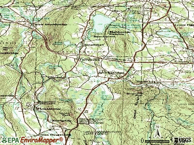
Notable locations in Stockbridge: Southbridge Industrial Park (A), Stockbridge Golf Course (B), Stockbridge Fire Department Station 4 (C), Merwin House Museum (D), Stockbridge Fire Department Station 3 (E), Stockbridge Fire Department Station 1 Headquarters (F), Berkshire Country Day School Library (G), Austen Fox Riggs Library (H), Lenox Arts Center (I), Wheatliegh Inn (J), Red Lion Inn (K), Chesterwood Museum (L), Tanglewood Auditorium (M), Merwin House (N), Mission House (O), Naumbeag Museum (P), Norman Rockwell Museum (Q). Display/hide their locations on the map
Churches in Stockbridge include: First Congregational Church (A), Bethel Baptist Church (B), The Marian Fathers Monastery (C). Display/hide their locations on the map
Cemeteries: Saint Josephs Cemetery (1), Stockbridge Cemetery (2), Saint Josephs Cemetery (3). Display/hide their locations on the map
Lakes and reservoirs: Hatch Pond (A), Clark Pond (B), Lily Pond (C), Mohawk Lake (D), Lake Averic (E), Agawam Lake (F), Stockbridge Bowl (G), Housatonic River Reservoir (H). Display/hide their locations on the map
Streams, rivers, and creeks: Shadow Brook (A), Duck Pond Brook (B), Newton Brook (C), Mahican Brook (D), Mohawk Brook (E), Larrywaug Brook (F), Lily Brook (G), Konkapot Brook (H), Kampoosa Brook (I). Display/hide their locations on the map
Parks in Stockbridge include: Berkshire Gardens Center (1), Berkshire Botanical Gardens (2), Field Arboretum (3). Display/hide their locations on the map
Tourist attractions: Chesterwood (Museums; 4 Williamsville Road), Holsten Galleries (Cultural Attractions- Events- & Facilities; 3 Elm Street), Historic New England Merwin House (Cultural Attractions- Events- & Facilities; West Main), Norman Rockwell Museum - Offices (9 Glendale Road).
Hotels: Blue Willow B & B (2 Lincoln Lane), Lion's Den (30 Main Street).
Birthplace of: Kenneth Whiting - Navy officer, Cyrus West Field - Businessman, Allen T. Treadway - Politician, Catharine Maria Sedgwick - (1789-1867), novelist, Daniel Spencer (Mormon) - Mormon missionary, Henry W. Dwight - Politician.
Drinking water stations with addresses in Stockbridge and their reported violations in the past:
STOCKBRIDGE WATER DEPT (Population served: 2,800, Surface water):Past monitoring violations:
- One minor monitoring violation
Drinking water stations with addresses in Stockbridge that have no violations reported:
- KRIPALU CENTER (Population served: 450, Primary Water Source Type: Purch surface water)
| This town: | 2.0 people |
| Massachusetts: | 2.5 people |
| This town: | 54.0% |
| Whole state: | 63.0% |
| This town: | 5.8% |
| Whole state: | 7.0% |
Likely homosexual households (counted as self-reported same-sex unmarried-partner households)
- Lesbian couples: 0.5% of all households
- Gay men: 0.2% of all households
| This town: | 8.5% |
| Whole state: | 9.3% |
| This town: | 3.2% |
| Whole state: | 4.4% |
People in group quarters in Stockbridge in 2010:
- 45 people in group homes intended for adults
- 36 people in mental (psychiatric) hospitals and psychiatric units in other hospitals
- 26 people in other noninstitutional facilities
- 20 people in residential treatment centers for adults
- 12 people in college/university student housing
People in group quarters in Stockbridge in 2000:
- 88 people in religious group quarters
- 70 people in other nonhousehold living situations
- 46 people in mental (psychiatric) hospitals or wards
- 30 people in homes for the mentally retarded
Banks with branches in Stockbridge (2011 data):
- Berkshire Bank: Stockbridge Branch at 32 Main Street, branch established on 1959/11/13. Info updated 2011/08/24: Bank assets: $3,955.6 mil, Deposits: $3,176.2 mil, headquarters in Pittsfield, MA, positive income, Commercial Lending Specialization, 64 total offices
- Lee Bank: Stockbridge Branch at Elm Street, branch established on 1974/10/15. Info updated 2006/11/03: Bank assets: $266.2 mil, Deposits: $181.6 mil, headquarters in Lee, MA, positive income, Commercial Lending Specialization, 3 total offices, Holding Company: Berkshire Financial Services, Inc.
For population 15 years and over in Stockbridge:
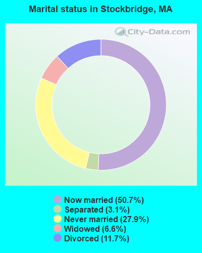
- Never married: 27.9%
- Now married: 50.7%
- Separated: 3.1%
- Widowed: 6.6%
- Divorced: 11.7%
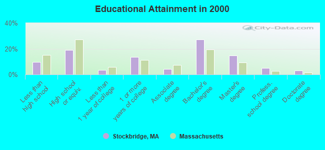
For population 25 years and over in Stockbridge:
- High school or higher: 90.4%
- Bachelor's degree or higher: 50.2%
- Graduate or professional degree: 23.1%
- Unemployed: 4.1%
- Mean travel time to work (commute): 18.1 minutes
| Here: | 12.3 |
| Massachusetts average: | 13.1 |


Graphs represent county-level data. Detailed 2008 Election Results
Religion statistics for Stockbridge, MA (based on Berkshire County data)


| Religion | Adherents | Congregations |
|---|---|---|
| Catholic | 50,187 | 32 |
| Mainline Protestant | 9,895 | 63 |
| Other | 3,647 | 20 |
| Evangelical Protestant | 2,817 | 28 |
| Black Protestant | 233 | 2 |
| Orthodox | 225 | 2 |
| None | 64,215 | - |
Food Environment Statistics:
| This county: | 2.54 / 10,000 pop. |
| Massachusetts: | 1.98 / 10,000 pop. |
| Berkshire County: | 1.61 / 10,000 pop. |
| Massachusetts: | 2.22 / 10,000 pop. |
| This county: | 4.08 / 10,000 pop. |
| Massachusetts: | 1.77 / 10,000 pop. |
| Berkshire County: | 15.00 / 10,000 pop. |
| State: | 8.76 / 10,000 pop. |
| This county: | 8.0% |
| Massachusetts: | 8.1% |
| This county: | 22.8% |
| Massachusetts: | 22.5% |
| Berkshire County: | 9.9% |
| Massachusetts: | 16.5% |
Strongest AM radio stations in Stockbridge:
- WSBS (860 AM; 3 kW; GREAT BARRINGTON, MA; Owner: BERKSHIRE BROADCASTING CO., INC.)
- WNNZ (640 AM; 50 kW; WESTFIELD, MA; Owner: CLEAR CHANNEL BROADCASTING LICENSES, INC.)
- WUHN (1110 AM; daytime; 5 kW; PITTSFIELD, MA; Owner: WEINER BROADCASTING, INC.)
- WGY (810 AM; 50 kW; SCHENECTADY, NY; Owner: CLEAR CHANNEL BROADCASTING LICENSES, INC.)
- WTIC (1080 AM; 50 kW; HARTFORD, CT; Owner: INFINITY RADIO OPERATIONS INC.)
- WPTR (1540 AM; 50 kW; ALBANY, NY; Owner: KIMTRON, INC.)
- WCRN (830 AM; 50 kW; WORCESTER, MA; Owner: CARTER BROADCASTING CORPORATION)
- WROW (590 AM; 5 kW; ALBANY, NY; Owner: 6 JOHNSON ROAD LICENSES, INC.)
- WVNE (760 AM; daytime; 25 kW; LEICESTER, MA; Owner: BLOUNT MASSCOM, INC.)
- WHYN (560 AM; 5 kW; SPRINGFIELD, MA; Owner: CLEAR CHANNEL BROADCASTING LICENSES, INC.)
- WBEC (1420 AM; 1 kW; PITTSFIELD, MA; Owner: GREAT NORTHERN RADIO, LLC)
- WFAN (660 AM; 50 kW; NEW YORK, NY; Owner: INFINITY BROADCASTING OPERATIONS, INC.)
- WMCA (570 AM; 50 kW; NEW YORK, NY; Owner: SALEM MEDIA OF NEW YORK, LLC)
Strongest FM radio stations in Stockbridge:
- WHVP (91.1 FM; HUDSON, NY; Owner: SOUND OF LIFE, INC.)
- WBEC-FM (105.5 FM; PITTSFIELD, MA; Owner: GREAT NORTHERN RADIO, LLC)
- WUPE (95.9 FM; PITTSFIELD, MA; Owner: WEINER BROADCASTING, INC.)
- WAMQ (105.1 FM; GREAT BARRINGTON, MA; Owner: WAMC)
- WAMC-FM (90.3 FM; ALBANY, NY; Owner: WAMC)
- WZEC (97.5 FM; HOOSICK FALLS, NY; Owner: GREAT NORTHERN RADIO, LLC)
- WEQX (102.7 FM; MANCHESTER, VT; Owner: NORTHSHIRE COMMUNICATIONS, INC.)
- WJAN (95.1 FM; SUNDERLAND, VT; Owner: 6 JOHNSON ROAD LICENSES, INC.)
- WAMK (90.9 FM; KINGSTON, NY; Owner: W A M C)
- WFGB (89.7 FM; KINGSTON, NY; Owner: SOUND OF LIFE, INC.)
- WHYN-FM (93.1 FM; SPRINGFIELD, MA; Owner: CLEAR CHANNEL BROADCASTING LICENSES, INC.)
- WVAY (100.7 FM; WILMINGTON, VT; Owner: GREAT NORTHERN RADIO, L.L.C.)
- WRNX (100.9 FM; AMHERST, MA; Owner: WESTERN MASSACHUSETTS RADIO COMPANY)
- WAJZ (96.3 FM; VOORHEESVILLE, NY; Owner: 6 JOHNSON ROAD LICENSES, INC.)
- WPDH (101.5 FM; POUGHKEEPSIE, NY; Owner: CUMULUS LICENSING CORP.)
- WZMR (104.9 FM; ALTAMONT, NY; Owner: 6 JOHNSON ROAD LICENSES, INC.)
- WYJB (95.5 FM; ALBANY, NY; Owner: 6 JOHNSON ROAD LICENSES, INC.)
- WRCH (100.5 FM; NEW BRITAIN, CT; Owner: INFINITY RADIO OPERATIONS INC.)
- WGNA-FM (107.7 FM; ALBANY, NY; Owner: REGENT LICENSEE OF MANSFIELD, INC.)
- WAQY (102.1 FM; SPRINGFIELD, MA; Owner: SAGA COMMUNICATIONS OF NEW ENGLAND, LLC)
TV broadcast stations around Stockbridge:
- WTIC-TV (Channel 61; HARTFORD, CT; Owner: TRIBUNE TELEVISION COMPANY)
- W11BJ (Channel 11; HARTFORD, CT; Owner: COMMUNICATIONS SITE MANAGEMENT LLC)
- WTXX (Channel 20; WATERBURY, CT; Owner: WTXX INC.)
- WUVN (Channel 18; HARTFORD, CT; Owner: ENTRAVISION HOLDINGS, LLC)
- National Bridge Inventory (NBI) Statistics
- 23Number of bridges
- 167ft / 51.0mTotal length
- $33,221,000Total costs
- 206,860Total average daily traffic
- 34,210Total average daily truck traffic
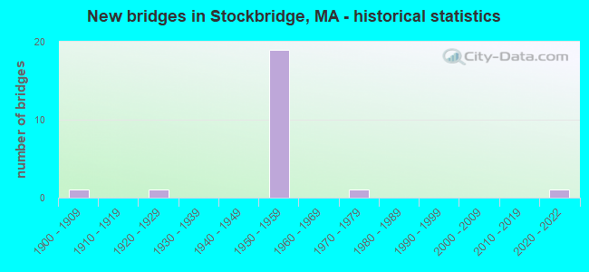
- New bridges - historical statistics
- 11900-1909
- 11920-1929
- 191950-1959
- 11970-1979
- 12020-2022
FCC Registered Antenna Towers:
27 (See the full list of FCC Registered Antenna Towers in Stockbridge)FCC Registered Broadcast Land Mobile Towers:
8 (See the full list of FCC Registered Broadcast Land Mobile Towers in Stockbridge, MA)FCC Registered Microwave Towers:
2- Stockbridge, Lat: 42.300556 Lon: -73.318889, Call Sign: WQJH716,
Assigned Frequencies: 1467.00 MHz, 1484.00 MHz, Grant Date: 09/13/2008, Expiration Date: 09/16/2008, Cancellation Date: 11/22/2008, Certifier: Argyle Nelson, Registrant: Aerial Video Systems, 712 South Main Street, Burbank, CA 91506, Phone: (818) 954-8842, Fax: (818) 954-9122, Email:
- Stockbridge, Lat: 42.300556 Lon: -73.318889, Call Sign: WQJH717,
Assigned Frequencies: 2367.00 MHz, 2384.00 MHz, Grant Date: 09/13/2008, Expiration Date: 09/16/2008, Cancellation Date: 11/22/2008, Certifier: Argyle Nelson, Registrant: Aerial Video Systems, 712 South Main Street, Burbank, CA 91506, Phone: (818) 954-8842, Fax: (818) 954-9122, Email:
FCC Registered Amateur Radio Licenses:
11 (See the full list of FCC Registered Amateur Radio Licenses in Stockbridge)FAA Registered Aircraft:
1- Aircraft: CESSNA 180B (Category: Land, Seats: 4, Weight: Up to 12,499 Pounds, Speed: 121 mph), Engine: CONT MOTOR O-470 SERIES (230 HP) (Reciprocating)
N-Number: 180KK, N180KK, N-180KK, Serial Number: 50401, Year manufactured: 1958, Airworthiness Date: 12/04/1958, Certificate Issue Date: 03/30/1998
Registrant (Individual): Kenneth F Krentsa, Po Box 903, Stockbridge, MA 01262
Deregistered: Cancel Date: 11/28/1997, Exported to: Canada
| Most common first names in Stockbridge, MA among deceased individuals | ||
| Name | Count | Lived (average) |
|---|---|---|
| John | 52 | 77.3 years |
| Mary | 48 | 82.8 years |
| Margaret | 32 | 81.5 years |
| William | 30 | 82.4 years |
| Robert | 30 | 71.5 years |
| Elizabeth | 22 | 82.8 years |
| Ruth | 20 | 81.3 years |
| Helen | 18 | 78.1 years |
| Grace | 16 | 81.7 years |
| George | 16 | 76.0 years |
| Most common last names in Stockbridge, MA among deceased individuals | ||
| Last name | Count | Lived (average) |
|---|---|---|
| Smith | 18 | 81.5 years |
| Cummings | 14 | 78.0 years |
| Haywood | 10 | 72.8 years |
| White | 10 | 83.6 years |
| Searing | 10 | 79.6 years |
| Cooney | 10 | 76.0 years |
| Williams | 10 | 78.8 years |
| Cahill | 10 | 79.4 years |
| Brown | 10 | 81.2 years |
| Touponce | 8 | 67.7 years |
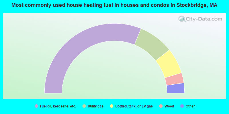
- 62.3%Fuel oil, kerosene, etc.
- 16.3%Utility gas
- 11.9%Bottled, tank, or LP gas
- 4.7%Wood
- 3.5%Electricity
- 1.2%Coal or coke
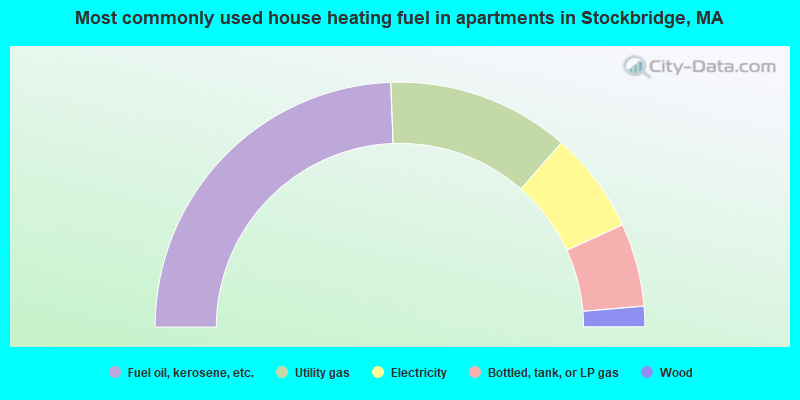
- 48.8%Fuel oil, kerosene, etc.
- 24.1%Utility gas
- 13.4%Electricity
- 11.0%Bottled, tank, or LP gas
- 2.7%Wood
Stockbridge compared to Massachusetts state average:
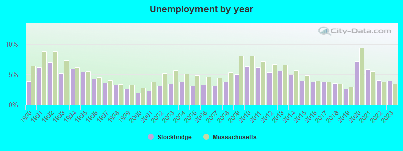
- Unemployed percentage significantly below state average.
- Black race population percentage significantly below state average.
- Hispanic race population percentage significantly below state average.
- Median age significantly above state average.
- Foreign-born population percentage below state average.
- Length of stay since moving in significantly above state average.
- Number of rooms per house significantly below state average.
- House age significantly below state average.
- Percentage of population with a bachelor's degree or higher above state average.
Stockbridge on our top lists:
- #10 on the list of "Top 101 cities with the largest percentage of people in religious group quarters (population 1,000+)"
- #27 on the list of "Top 101 cities with the largest percentage of people in other nonhousehold living situations (population 1,000+)"
- #31 on the list of "Top 101 cities with the largest percentage of people in mental (psychiatric) hospitals or wards (population 1,000+)"
- #53 on the list of "Top 101 cities with the most residents born in Other Caribbean (population 500+)"
- #14 on the list of "Top 101 counties with the lowest number of births per 1000 residents 2007-2013"
- #22 on the list of "Top 101 counties with the lowest percentage of residents relocating from other counties between 2010 and 2011"
- #28 on the list of "Top 101 counties with the lowest percentage of residents relocating to other counties in 2011"
- #53 on the list of "Top 101 counties with highest percentage of residents voting for Obama (Democrat) in the 2012 Presidential Election"
- #71 on the list of "Top 101 counties with the largest number of people moving out compared to moving in (pop. 50,000+)"

|
|
Total of 13 patent applications in 2008-2024.