Richmond, Massachusetts
Submit your own pictures of this town and show them to the world
- OSM Map
- General Map
- Google Map
- MSN Map
Population change since 2000: -8.0%
 |
| Males: 715 | |
| Females: 760 |
| Median resident age: | 52.4 years |
| Massachusetts median age: | 39.2 years |
Zip codes: 01254.
| Richmond: | $115,722 |
| MA: | $94,488 |
Estimated per capita income in 2022: $79,779 (it was $35,568 in 2000)
Richmond town income, earnings, and wages data
Estimated median house or condo value in 2022: $558,907 (it was $209,000 in 2000)
| Richmond: | $558,907 |
| MA: | $534,700 |
Mean prices in 2022: all housing units: $357,971; detached houses: $376,086; townhouses or other attached units: $341,816; in 2-unit structures: $250,940; in 3-to-4-unit structures: $400,871; in 5-or-more-unit structures: $281,990; mobile homes: $80,872
Detailed information about poverty and poor residents in Richmond, MA
Compare current foreclosures near Richmond, MA:
| Photo | Address | Area | Beds / Baths | Price | Details |
|---|---|---|---|---|---|

|
#1
Crystal St
Lenox Dale, MA 01242
|
1,918 sq. feet
|
2 baths 3 beds |
$165,900
|
show details |

|
#2
Washington Mountain Rd
Lee, MA 01238
|
- sq. feet
|
1 baths 3 beds |
$155,000
|
show details |

|
#3
Wilshire Dr
Cheshire, MA 01225
|
4,302 sq. feet
|
2 baths 3 beds |
show details | |

|
#4
Crane Ave
Pittsfield, MA 01201
|
981 sq. feet
|
1 baths 2 beds |
show details | |

|
#5
Tierney Pl
Pittsfield, MA 01201
|
1,103 sq. feet
|
1 baths 3 beds |
show details | |

|
#6
Marion Blvd
Valatie, NY 12184
|
1,180 sq. feet
|
2 baths 3 beds |
show details | |

|
#7
Garfield Ave
Pittsfield, MA 01201
|
2,432 sq. feet
|
2 baths 4 beds |
show details | |

|
#8
Hancock Rd
Pittsfield, MA 01201
|
1,344 sq. feet
|
2 baths 3 beds |
show details | |

|
#9
Chapel St
Lee, MA 01238
|
1,584 sq. feet
|
1 baths 3 beds |
show details | |

|
#10
Imperial Ave
Pittsfield, MA 01201
|
1,326 sq. feet
|
1 baths 3 beds |
show details |
| Photo | Address | Area | Beds / Baths | Price | Details |
|---|---|---|---|---|---|

|
#11
Route 203
Valatie, NY 12184
|
1,271 sq. feet
|
2 baths 3 beds |
show details | |

|
#12
Park Ave
Nassau, NY 12123
|
1,734 sq. feet
|
1 baths 3 beds |
show details | |

|
#13
Upper Queechy Rd
Canaan, NY 12029
|
912 sq. feet
|
1 baths 2 beds |
show details | |

|
#14
Lenox Ave
Pittsfield, MA 01201
|
2,290 sq. feet
|
2 baths 6 beds |
show details | |

|
#15
Ashuelot St
Dalton, MA 01226
|
1,792 sq. feet
|
2 baths 3 beds |
show details | |

|
#16
Grange Hall Rd
Stephentown, NY 12168
|
1,670 sq. feet
|
1 baths 2 beds |
show details | |

|
#17
Westbrook Dr
Nassau, NY 12123
|
768 sq. feet
|
1 baths 2 beds |
show details | |

|
#18
North St
Dalton, MA 01226
|
1,852 sq. feet
|
2 baths 4 beds |
show details | |

|
#19
Roxbury Rd
Chatham, NY 12037
|
1,820 sq. feet
|
1 baths 3 beds |
show details | |

|
#20
Richard Ln
Niverville, NY 12130
|
1,320 sq. feet
|
1 baths 3 beds |
show details |
| Photo | Address | Area | Beds / Baths | Price | Details |
|---|---|---|---|---|---|

|
#21
Eberle Rd Ext
Valatie, NY 12184
|
2,006 sq. feet
|
1 baths 1 beds |
show details | |

|
#22
County Route 21
Ghent, NY 12075
|
2,819 sq. feet
|
2 baths 6 beds |
show details | |

|
#23
Kathy Way
Pittsfield, MA 01201
|
2,136 sq. feet
|
2 baths 3 beds |
show details | |

|
#24
Donovan St
Pittsfield, MA 01201
|
1,652 sq. feet
|
2 baths 3 beds |
show details | |

|
#25
Longfellow Ave
Pittsfield, MA 01201
|
1,356 sq. feet
|
1 baths 4 beds |
show details | |

|
#26
Daniels Ave
Pittsfield, MA 01201
|
1,172 sq. feet
|
1 baths 3 beds |
show details | |

|
#27
West St
Pittsfield, MA 01201
|
2,018 sq. feet
|
1 baths 3 beds |
show details | |

|
#28
Frisbee St
East Chatham, NY 12060
|
2,400 sq. feet
|
2 baths 4 beds |
show details | |

|
#29
Morgan St
Lenox, MA 01240
|
3,959 sq. feet
|
2 baths 3 beds |
show details | |

|
#30
Joseph Dr
Pittsfield, MA 01201
|
1,248 sq. feet
|
1 baths 3 beds |
show details |
| Photo | Address | Area | Beds / Baths | Price | Details |
|---|---|---|---|---|---|

|
#31
Summit Ave
Pittsfield, MA 01201
|
1,664 sq. feet
|
2 baths 4 beds |
show details | |

|
#32
Mcarthur St
Pittsfield, MA 01201
|
1,155 sq. feet
|
1 baths 2 beds |
show details | |

|
#33
Melville Ct
Lenox, MA 01240
|
3,988 sq. feet
|
6 baths 5 beds |
show details | |

|
#34
West St
Pittsfield, MA 01201
|
1,714 sq. feet
|
1 baths 4 beds |
show details | |

|
#35
Crystal St
Pittsfield, MA 01201
|
1,282 sq. feet
|
1 baths 3 beds |
show details | |

|
#36
Stockbridge Rd
Lee, MA 01238
|
4,695 sq. feet
|
4 baths 5 beds |
show details | |

|
#37
Briggs Ave
Pittsfield, MA 01201
|
2,116 sq. feet
|
2 baths 4 beds |
show details | |

|
#38
Lenox Ave
Pittsfield, MA 01201
|
1,376 sq. feet
|
1 baths 3 beds |
show details | |

|
#39
Route 23
Hillsdale, NY 12529
|
2,762 sq. feet
|
2 baths 4 beds |
show details | |

|
#40
Blunt Rd
Great Barrington, MA 01230
|
- sq. feet
|
- baths - beds |
show details |
| Photo | Address | Area | Beds / Baths | Price | Details |
|---|---|---|---|---|---|

|
#41
Morey Park Hill Rd
Nassau, NY 12123
|
- sq. feet
|
- baths - beds |
show details | |

|
#42
County Route 21
Valatie, NY 12184
|
- sq. feet
|
- baths - beds |
show details | |

|
#43
Lake Ave Apt 2
Nassau, NY 12123
|
- sq. feet
|
- baths - beds |
show details | |

|
#44
Van Buren Ave
Niverville, NY 12130
|
- sq. feet
|
- baths - beds |
show details | |

|
#45
Van Buren Ave
Niverville, NY 12130
|
- sq. feet
|
- baths - beds |
show details | |

|
#46
Malden Bridge Rd
Nassau, NY 12123
|
- sq. feet
|
- baths - beds |
show details | |

|
#47
West Rd
Southfield, MA 01259
|
- sq. feet
|
- baths - beds |
show details | |

|
#48
Dogwood Knls
Valatie, NY 12184
|
- sq. feet
|
- baths - beds |
show details | |

|
#49
Us Highway 20 # 824
Nassau, NY 12123
|
- sq. feet
|
- baths - beds |
show details | |

|
Check over 1 million property listings on Foreclosure.com!
|
browse all offers | |||

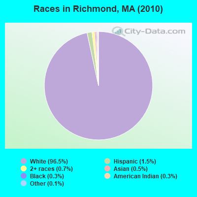
- 1,42496.5%White alone
- 221.5%Hispanic
- 110.7%Two or more races
- 80.5%Asian alone
- 40.3%Black alone
- 40.3%American Indian alone
- 20.1%Other race alone
Races in Richmond detailed stats: ancestries, foreign born residents, place of birth
According to our research of Massachusetts and other state lists, there was 1 registered sex offender living in Richmond, Massachusetts as of April 28, 2024.
The ratio of all residents to sex offenders in Richmond is 1,475 to 1.
The ratio of registered sex offenders to all residents in this city is near the state average.
 Recent articles from our blog. Our writers, many of them Ph.D. graduates or candidates, create easy-to-read articles on a wide variety of topics.

 | $20 minimum wage proposed in MA (344 replies) |
| Why is Boston so famous for its racism?! (1466 replies) |
| MA Real Estate is CRAZY (344 replies) |
| Individual Votes By Cities/Towns Whether To Allow Marijuana businesses (599 replies) |
| Amazon New HQ (50k jobs), MA? (557 replies) |
| How is downtown Springfield? (140 replies) |
Latest news from Richmond, MA collected exclusively by city-data.com from local newspapers, TV, and radio stations
Ancestries: Irish (23.3%), Italian (20.8%), English (16.5%), French (13.5%), German (12.1%), Polish (7.5%).
Current Local Time: EST time zone
Incorporated in 1765
Elevation: 1057 feet
Land area: 19.0 square miles.
Population density: 78 people per square mile (very low).
54 residents are foreign born (2.1% Europe, 0.7% Asia).
| This town: | 3.4% |
| Massachusetts: | 12.2% |
| Richmond town: | 1.1% ($2,393) |
| Massachusetts: | 1.3% ($2,336) |
Nearest city with pop. 50,000+: Albany, NY  (28.8 miles , pop. 95,658).
Nearest city with pop. 200,000+: Bronx, NY (109.5 miles , pop. 1,332,650).
Nearest cities:
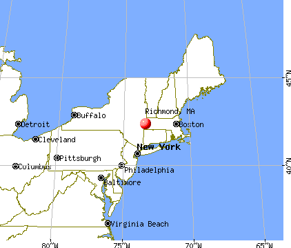
), ), )Latitude: 42.38 N, Longitude: 73.36 W
Area code: 413


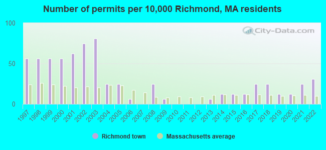
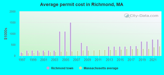
Single-family new house construction building permits:
- 2022: 5 buildings, average cost: $750,000
- 2021: 4 buildings, average cost: $750,000
- 2020: 2 buildings, average cost: $650,000
- 2019: 2 buildings, average cost: $650,000
- 2018: 4 buildings, average cost: $450,000
- 2017: 4 buildings, average cost: $450,000
- 2016: 2 buildings, average cost: $435,000
- 2015: 2 buildings, average cost: $435,000
- 2014: 2 buildings, average cost: $435,000
- 2013: 1 building, cost: $430,000
- 2009: 1 building, cost: $450,000
- 2008: 4 buildings, average cost: $602,500
- 2006: 1 building, cost: $1,510,000
- 2005: 4 buildings, average cost: $1,111,800
- 2004: 4 buildings, average cost: $1,111,800
- 2003: 13 buildings, average cost: $248,900
- 2002: 12 buildings, average cost: $248,900
- 2001: 10 buildings, average cost: $248,900
- 2000: 9 buildings, average cost: $248,900
- 1999: 9 buildings, average cost: $248,900
- 1998: 9 buildings, average cost: $248,900
- 1997: 9 buildings, average cost: $160,000
| Here: | 2.8% |
| Massachusetts: | 3.5% |

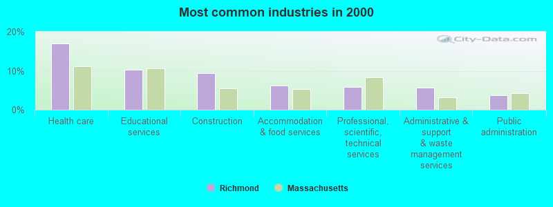
- Health care (17.0%)
- Educational services (10.3%)
- Construction (9.5%)
- Accommodation & food services (6.2%)
- Professional, scientific, technical services (5.8%)
- Administrative & support & waste management services (5.6%)
- Public administration (3.6%)
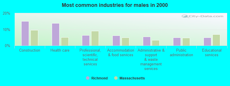
- Construction (15.1%)
- Health care (13.8%)
- Professional, scientific, technical services (6.3%)
- Accommodation & food services (6.1%)
- Administrative & support & waste management services (5.5%)
- Public administration (5.0%)
- Educational services (5.0%)
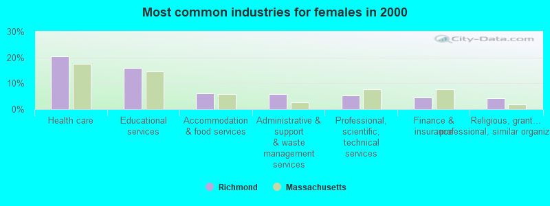
- Health care (20.5%)
- Educational services (16.0%)
- Accommodation & food services (6.2%)
- Administrative & support & waste management services (5.7%)
- Professional, scientific, technical services (5.2%)
- Finance & insurance (4.5%)
- Religious, grantmaking, civic, professional, similar organizations (4.3%)
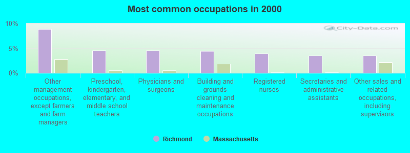
- Other management occupations, except farmers and farm managers (8.9%)
- Preschool, kindergarten, elementary, and middle school teachers (4.6%)
- Physicians and surgeons (4.6%)
- Building and grounds cleaning and maintenance occupations (4.4%)
- Registered nurses (3.9%)
- Secretaries and administrative assistants (3.5%)
- Other sales and related occupations, including supervisors (3.5%)
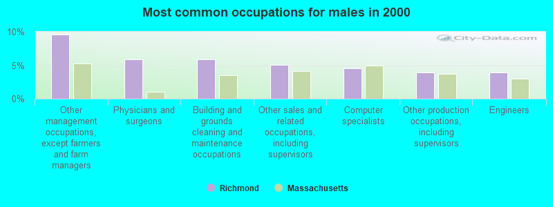
- Other management occupations, except farmers and farm managers (9.6%)
- Physicians and surgeons (5.9%)
- Building and grounds cleaning and maintenance occupations (5.9%)
- Other sales and related occupations, including supervisors (5.0%)
- Computer specialists (4.6%)
- Other production occupations, including supervisors (3.9%)
- Engineers (3.9%)
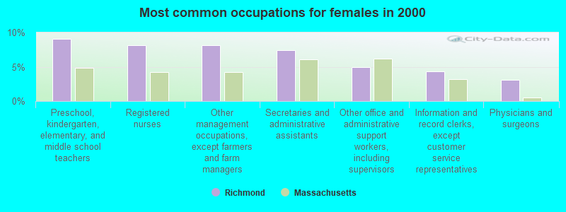
- Preschool, kindergarten, elementary, and middle school teachers (9.0%)
- Registered nurses (8.1%)
- Other management occupations, except farmers and farm managers (8.1%)
- Secretaries and administrative assistants (7.4%)
- Other office and administrative support workers, including supervisors (5.0%)
- Information and record clerks, except customer service representatives (4.3%)
- Physicians and surgeons (3.1%)
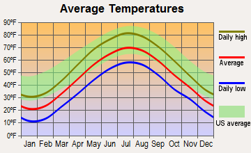
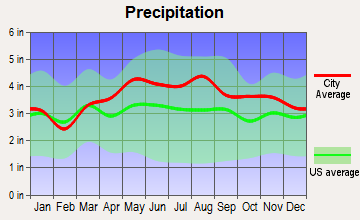
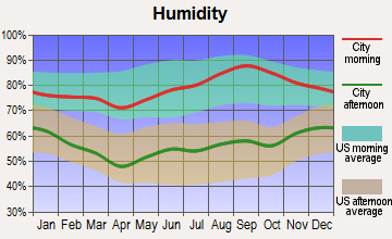
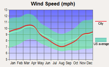
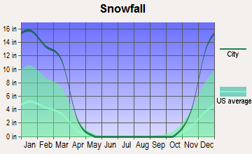
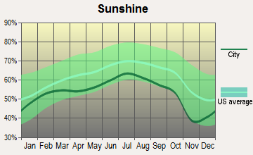
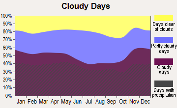
Average climate in Richmond, Massachusetts
Based on data reported by over 4,000 weather stations
(lower is better)
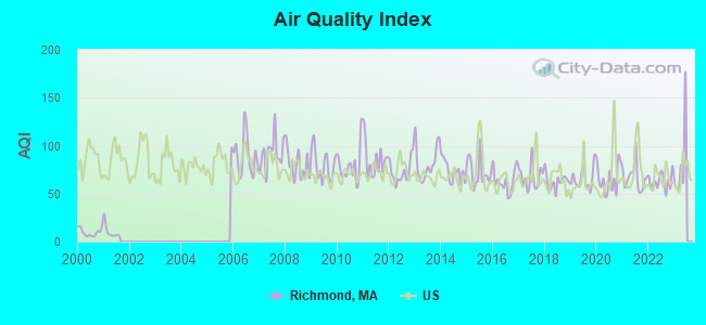
Air Quality Index (AQI) level in 2022 was 63.2. This is about average.
| City: | 63.2 |
| U.S.: | 72.6 |
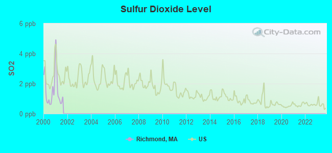
Sulfur Dioxide (SO2) [ppb] level in 2001 was 1.71. This is about average. Closest monitor was 6.3 miles away from the city center.
| City: | 1.71 |
| U.S.: | 1.51 |
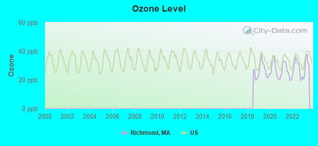
Ozone [ppb] level in 2022 was 27.5. This is better than average. Closest monitor was 7.8 miles away from the city center.
| City: | 27.5 |
| U.S.: | 33.3 |
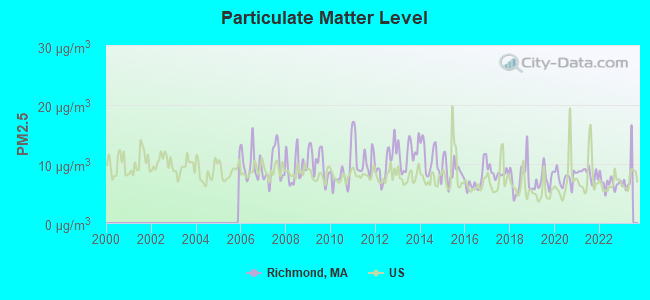
Particulate Matter (PM2.5) [µg/m3] level in 2022 was 6.76. This is about average. Closest monitor was 7.1 miles away from the city center.
| City: | 6.76 |
| U.S.: | 8.11 |
Tornado activity:
Richmond-area historical tornado activity is slightly above Massachusetts state average. It is 21% smaller than the overall U.S. average.
On 8/28/1973, a category F4 (max. wind speeds 207-260 mph) tornado 4.0 miles away from the Richmond town center killed 4 people and injured 36 people and caused between $5,000,000 and $50,000,000 in damages.
On 5/29/1995, a category F4 tornado 13.1 miles away from the town center killed 3 people and injured 24 people and caused between $5,000,000 and $50,000,000 in damages.
Earthquake activity:
Richmond-area historical earthquake activity is significantly above Massachusetts state average. It is 68% smaller than the overall U.S. average.On 10/7/1983 at 10:18:46, a magnitude 5.3 (5.1 MB, 5.3 LG, 5.1 ML, Class: Moderate, Intensity: VI - VII) earthquake occurred 119.4 miles away from Richmond center
On 4/20/2002 at 10:50:47, a magnitude 5.3 (5.3 ML, Depth: 3.0 mi) earthquake occurred 148.3 miles away from the city center
On 4/20/2002 at 10:50:47, a magnitude 5.2 (5.2 MB, 4.2 MS, 5.2 MW, 5.0 MW) earthquake occurred 146.7 miles away from Richmond center
On 1/19/1982 at 00:14:42, a magnitude 4.7 (4.5 MB, 4.7 MD, 4.5 LG, Class: Light, Intensity: IV - V) earthquake occurred 118.0 miles away from the city center
On 10/16/2012 at 23:12:25, a magnitude 4.7 (4.7 ML, Depth: 10.0 mi) earthquake occurred 160.6 miles away from the city center
On 6/17/1991 at 08:53:16, a magnitude 4.1 (4.0 MB, 4.0 LG, Depth: 3.1 mi) earthquake occurred 69.3 miles away from Richmond center
Magnitude types: regional Lg-wave magnitude (LG), body-wave magnitude (MB), duration magnitude (MD), local magnitude (ML), surface-wave magnitude (MS), moment magnitude (MW)
Natural disasters:
The number of natural disasters in Berkshire County (21) is greater than the US average (15).Major Disasters (Presidential) Declared: 10
Emergencies Declared: 10
Causes of natural disasters: Floods: 5, Snowstorms: 5, Storms: 5, Hurricanes: 4, Winter Storms: 4, Blizzards: 2, Snows: 2, Snowfall: 1, Tropical Storm: 1, Wind: 1, Other: 1 (Note: some incidents may be assigned to more than one category).
Hospitals and medical centers near Richmond:
- EDGECOMBE NURSING HOME (Nursing Home, about 5 miles away; LENOX, MA)
- KIMBALL FARMS NURSING CARE CENTER (Nursing Home, about 5 miles away; LENOX, MA)
- SPRINGSIDE REHABILITATION AND SKILLED CARE CENTER (Nursing Home, about 5 miles away; PITTSFIELD, MA)
- PROVIDENCE CARE CENTER - LENOX (Nursing Home, about 5 miles away; LENOX, MA)
- VALLEY VIEW NURSING HOME (Nursing Home, about 6 miles away; LENOX, MA)
- NURSING CARE CENTER AT KIMBALL (Nursing Home, about 6 miles away; LENOX, MA)
- CENTER FOR OPTIMUM CARE-BERKSHIRE (Nursing Home, about 7 miles away; PITTSFIELD, MA)
Colleges/universities with over 2000 students nearest to Richmond:
- Williams College (about 25 miles; Williamstown, MA; Full-time enrollment: 2,141)
- Hudson Valley Community College (about 28 miles; Troy, NY; FT enrollment: 9,346)
- Rensselaer Polytechnic Institute (about 29 miles; Troy, NY; FT enrollment: 6,940)
- The College of Saint Rose (about 30 miles; Albany, NY; FT enrollment: 4,085)
- The Sage Colleges (about 30 miles; Troy, NY; FT enrollment: 2,499)
- Siena College (about 31 miles; Loudonville, NY; FT enrollment: 3,153)
- SUNY at Albany (about 32 miles; Albany, NY; FT enrollment: 15,490)
Public elementary/middle school in Richmond:
- RICHMOND CONSOLIDATED (Students: 178, Location: 1831 STATE RD, Grades: PK-8)
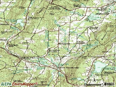
Points of interest:
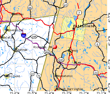
Notable locations in Richmond: Bartlett's Orchard (A), Hilltop Orchards (B), Richmond Fire Department Ambulance Service (C), Richmond Fire Department (D). Display/hide their locations on the map
Cemeteries: Center Cemetery (1), Northeast Cemetery (2), North Cemetery (3), Cone Hill Cemetery (4). Display/hide their locations on the map
Lakes and reservoirs: Fairfield Pond (A), Crystal Lake (B), Richmond Pond (C). Display/hide their locations on the map
Streams, rivers, and creeks: Tracy Brook (A), Sleepy Hollow Brook (B), Royes Brook (C), Mount Lebanon Brook (D), Lenox Mountain Brook (E), Ford Brook (F), Fairfield Brook (G). Display/hide their locations on the map
Birthplace of: Rix Robinson - Politician, Edward A. Perry - Governor of Florida.
Drinking water stations with addresses in Richmond and their reported violations in the past:
VIEW DRIVE WATER COMMUNITY COOPERATIVE (Population served: 38, Groundwater):Past health violations:Past monitoring violations:
- MCL, Monthly (TCR) - In JAN-2013, Contaminant: Coliform. Follow-up actions: St AO (w/o penalty) issued (JUN-25-2013)
- MCL, Monthly (TCR) - In DEC-2012, Contaminant: Coliform. Follow-up actions: St AO (w/o penalty) issued (2 times from JAN-14-2013 to JUN-25-2013)
- Follow-up Or Routine LCR Tap M/R - In JAN-01-2013, Contaminant: Lead and Copper Rule. Follow-up actions: St AO (w/o penalty) issued (MAR-07-2014)
- Follow-up Or Routine LCR Tap M/R - In JAN-01-2011, Contaminant: Lead and Copper Rule
| This town: | 2.2 people |
| Massachusetts: | 2.5 people |
| This town: | 68.3% |
| Whole state: | 63.0% |
| This town: | 5.5% |
| Whole state: | 7.0% |
Likely homosexual households (counted as self-reported same-sex unmarried-partner households)
- Lesbian couples: 1.2% of all households
- Gay men: 0.6% of all households
| This town: | 3.1% |
| Whole state: | 9.3% |
| This town: | 0.9% |
| Whole state: | 4.4% |
3 people in other nonhousehold living situations in 2000
For population 15 years and over in Richmond:
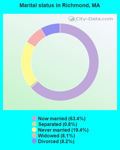
- Never married: 19.4%
- Now married: 63.4%
- Separated: 0.8%
- Widowed: 8.1%
- Divorced: 8.2%
For population 25 years and over in Richmond:
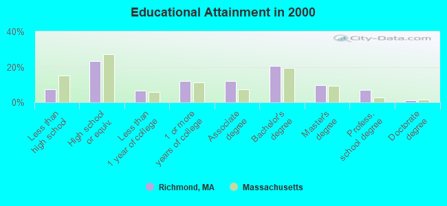
- High school or higher: 92.7%
- Bachelor's degree or higher: 38.6%
- Graduate or professional degree: 18.1%
- Unemployed: 3.2%
- Mean travel time to work (commute): 24.1 minutes
| Here: | 10.7 |
| Massachusetts average: | 13.1 |


Graphs represent county-level data. Detailed 2008 Election Results
Religion statistics for Richmond, MA (based on Berkshire County data)


| Religion | Adherents | Congregations |
|---|---|---|
| Catholic | 50,187 | 32 |
| Mainline Protestant | 9,895 | 63 |
| Other | 3,647 | 20 |
| Evangelical Protestant | 2,817 | 28 |
| Black Protestant | 233 | 2 |
| Orthodox | 225 | 2 |
| None | 64,215 | - |
Food Environment Statistics:
| Berkshire County: | 2.54 / 10,000 pop. |
| Massachusetts: | 1.98 / 10,000 pop. |
| This county: | 1.61 / 10,000 pop. |
| Massachusetts: | 2.22 / 10,000 pop. |
| This county: | 4.08 / 10,000 pop. |
| Massachusetts: | 1.77 / 10,000 pop. |
| Here: | 15.00 / 10,000 pop. |
| State: | 8.76 / 10,000 pop. |
| This county: | 8.0% |
| Massachusetts: | 8.1% |
| Here: | 22.8% |
| Massachusetts: | 22.5% |
| This county: | 9.9% |
| Massachusetts: | 16.5% |
Strongest AM radio stations in Richmond:
- WUHN (1110 AM; daytime; 5 kW; PITTSFIELD, MA; Owner: WEINER BROADCASTING, INC.)
- WNNZ (640 AM; 50 kW; WESTFIELD, MA; Owner: CLEAR CHANNEL BROADCASTING LICENSES, INC.)
- WGY (810 AM; 50 kW; SCHENECTADY, NY; Owner: CLEAR CHANNEL BROADCASTING LICENSES, INC.)
- WPTR (1540 AM; 50 kW; ALBANY, NY; Owner: KIMTRON, INC.)
- WSBS (860 AM; 3 kW; GREAT BARRINGTON, MA; Owner: BERKSHIRE BROADCASTING CO., INC.)
- WBEC (1420 AM; 1 kW; PITTSFIELD, MA; Owner: GREAT NORTHERN RADIO, LLC)
- WTIC (1080 AM; 50 kW; HARTFORD, CT; Owner: INFINITY RADIO OPERATIONS INC.)
- WROW (590 AM; 5 kW; ALBANY, NY; Owner: 6 JOHNSON ROAD LICENSES, INC.)
- WCRN (830 AM; 50 kW; WORCESTER, MA; Owner: CARTER BROADCASTING CORPORATION)
- WBRK (1340 AM; 1 kW; PITTSFIELD, MA; Owner: WBRK, INC.)
- WVNE (760 AM; daytime; 25 kW; LEICESTER, MA; Owner: BLOUNT MASSCOM, INC.)
- WTMM (1300 AM; 5 kW; RENSSELAER, NY; Owner: REGENT LICENSEE OF MANSFIELD, INC.)
- WFAN (660 AM; 50 kW; NEW YORK, NY; Owner: INFINITY BROADCASTING OPERATIONS, INC.)
Strongest FM radio stations in Richmond:
- WBEC-FM (105.5 FM; PITTSFIELD, MA; Owner: GREAT NORTHERN RADIO, LLC)
- WUPE (95.9 FM; PITTSFIELD, MA; Owner: WEINER BROADCASTING, INC.)
- WHVP (91.1 FM; HUDSON, NY; Owner: SOUND OF LIFE, INC.)
- WAMC-FM (90.3 FM; ALBANY, NY; Owner: WAMC)
- WAMQ (105.1 FM; GREAT BARRINGTON, MA; Owner: WAMC)
- WZEC (97.5 FM; HOOSICK FALLS, NY; Owner: GREAT NORTHERN RADIO, LLC)
- WEQX (102.7 FM; MANCHESTER, VT; Owner: NORTHSHIRE COMMUNICATIONS, INC.)
- WJAN (95.1 FM; SUNDERLAND, VT; Owner: 6 JOHNSON ROAD LICENSES, INC.)
- WAMK (90.9 FM; KINGSTON, NY; Owner: W A M C)
- WFGB (89.7 FM; KINGSTON, NY; Owner: SOUND OF LIFE, INC.)
- WBRK-FM (101.7 FM; PITTSFIELD, MA; Owner: WBRK, INC.)
- WVAY (100.7 FM; WILMINGTON, VT; Owner: GREAT NORTHERN RADIO, L.L.C.)
- WAJZ (96.3 FM; VOORHEESVILLE, NY; Owner: 6 JOHNSON ROAD LICENSES, INC.)
- WZMR (104.9 FM; ALTAMONT, NY; Owner: 6 JOHNSON ROAD LICENSES, INC.)
- WYJB (95.5 FM; ALBANY, NY; Owner: 6 JOHNSON ROAD LICENSES, INC.)
- WGNA-FM (107.7 FM; ALBANY, NY; Owner: REGENT LICENSEE OF MANSFIELD, INC.)
- WHYN-FM (93.1 FM; SPRINGFIELD, MA; Owner: CLEAR CHANNEL BROADCASTING LICENSES, INC.)
- WRVE (99.5 FM; SCHENECTADY, NY; Owner: CLEAR CHANNEL BROADCASTING LICENSES, INC.)
- WMHT-FM (89.1 FM; SCHENECTADY, NY; Owner: WMHT EDUCATIONAL TELECOMMUNICATIONS)
- WPYX (106.5 FM; ALBANY, NY; Owner: CAPSTAR TX LIMITED PARTNERSHIP)
TV broadcast stations around Richmond:
- WTIC-TV (Channel 61; HARTFORD, CT; Owner: TRIBUNE TELEVISION COMPANY)
- W07AI (Channel 7; PITTSFIELD, ETC., MA; Owner: WNYT-TV, LLC)
- WCDC-TV (Channel 19; ADAMS, MA; Owner: YOUNG BROADCASTING OF ALBANY, INC.)
- Richmond, Massachusetts
- Fatal accident count19
- Vehicles involved in fatal accidents25
- Fatal accidents involving drunk persons:6
- Fatalities20
- Persons involved in fatal accidents41
- Pedestrians involved in fatal accidents1
- Massachusetts average
- Fatal accident count7081
- Vehicles involved in fatal accidents10067
- Fatal accidents involving drunk persons2414
- Fatalities7630
- Persons involved in fatal accidents15960
- Pedestrians involved in fatal accidents816
- National Bridge Inventory (NBI) Statistics
- 3Number of bridges
- 26ft / 8.1mTotal length
- $7,787,000Total costs
- 3,682Total average daily traffic
- 209Total average daily truck traffic
- 6,017Total future (year 2031) average daily traffic
FCC Registered Antenna Towers:
3- Stephen Flessner, Lenox Mountain, Osceola Notch Rd (Lat: 42.392778 Lon: -73.311472), Type: 36.6, Structure height: 25003 m, Overall height: 30.5 m, Registrant: Spectrum Northeast, LLC, Charterfcc@charter.Com, , St. L-ouis, Phone: (303) 323-1423
- Stephen Flessner, Lenox Mountain, Osceola Notch Rd (Lat: 42.392778 Lon: -73.311472), Type: 36.6, Structure height: 25003 m, Overall height: 30.5 m, Registrant: Spectrum Northeast, LLC, Charterfcc@charter.Com, , St. L-ouis, Phone: (303) 323-1423
- Henry Byrne, Lenox Mountain, Osceola Notch Rd (Lat: 42.392778 Lon: -73.311472), Type: 36.6, Structure height: 25003 m, Overall height: 30.5 m, Registrant: Towerco V Holdings LLC, Hbyrne@towerco.Com, Suite 200, Cary, Phone: (919) 272-7766
FCC Registered Broadcast Land Mobile Towers:
2- Fire Station State St (Lat: 42.374528 Lon: -73.368722), Call Sign: KNEY879,
Assigned Frequencies: 154.310 MHz, Grant Date: 12/19/2012, Expiration Date: 03/01/2023, Cancellation Date: 05/06/2023, Registrant: Richmond Vol. Fire Department, 35 Firehouse Lane, Richmond, MA 01254, Phone: (413) 698-3366, Fax: (413) 698-8686, Email:
- Highway Garage Rt 41 (Lat: 42.373417 Lon: -73.368444), Call Sign: KNGN544, Licensee ID: L00033872,
Assigned Frequencies: 154.100 MHz, Grant Date: 05/17/2003, Expiration Date: 05/04/2013, Cancellation Date: 07/06/2013, Registrant: Richmond, Town Of, 53 Firehouse Ln, Richmond, MA 01254
FCC Registered Microwave Towers:
2- LENOX MTN, Lenox Mountain, Osceola Notch Rd (Lat: 42.392778 Lon: -73.311472), Type: Gtower, Structure height: 30.5 m, Overall height: 36.6 m, Call Sign: WQNC844,
Assigned Frequencies: 11305.0 MHz, 6093.45 MHz, 10563.1 MHz, Grant Date: 09/29/2020, Expiration Date: 12/21/2030, Certifier: Charles B Sutherland, Registrant: Massachusetts, Commonwealth Of, 470 Worcester Rd, Framingham, MA 01702, Phone: (508) 820-2264, Email:
- RICHMOND YUK, 0 Yukon Road (Lat: 42.392778 Lon: -73.311472), Type: Gtower, Structure height: 30.5 m, Overall height: 36.6 m, Call Sign: WQQQ278,
Assigned Frequencies: 19400.0 MHz, 19525.0 MHz, 19575.0 MHz, 19625.0 MHz, 19675.0 MHz, Grant Date: 01/10/2023, Expiration Date: 02/12/2033, Certifier: John Monday, Registrant: At&t Services, Inc., 208 S Akard St, 20f, Dallas, TX 75202, Phone: (855) 699-7073, Email:
FCC Registered Amateur Radio Licenses:
12 (See the full list of FCC Registered Amateur Radio Licenses in Richmond)FAA Registered Aircraft:
2- Aircraft: CESSNA 150L (Category: Land, Seats: 2, Weight: Up to 12,499 Pounds, Speed: 90 mph), Engine: CONT MOTOR 0-200 SERIES (100 HP) (Reciprocating)
N-Number: 1492Q, N1492Q, N-1492Q, Serial Number: 15072792, Airworthiness Date: 08/30/1971, Certificate Issue Date: 08/03/2020
Registrant (Individual): James D Davison, 1590 Swamp Rd, Richmond, MA 01254
Deregistered: Cancel Date: 09/06/2019 - Aircraft: CESSNA 172N (Category: Land, Seats: 4, Weight: Up to 12,499 Pounds, Speed: 105 mph), Engine: LYCOMING 0-320 SERIES (180 HP) (Reciprocating)
N-Number: 34LC, N34LC, N-34LC, Serial Number: 17272203, Year manufactured: 1979, Airworthiness Date: 02/06/1979, Certificate Issue Date: 08/25/2016
Registrant (Individual): Mary Ann Serian, 1580 State Rd, Richmond, MA 01254
2002 - 2018 National Fire Incident Reporting System (NFIRS) incidents
- Fire incident types reported to NFIRS in Richmond, MA
- 9045.0%Outside Fires
- 8743.5%Structure Fires
- 178.5%Mobile Property/Vehicle Fires
- 63.0%Other
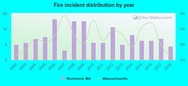 Based on the data from the years 2002 - 2018 the average number of fire incidents per year is 12. The highest number of fire incidents - 21 took place in 2006, and the least - 5 in 2007. The data has a decreasing trend.
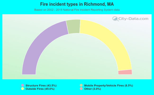 When looking into fire subcategories, the most reports belonged to: Outside Fires (45.0%), and Structure Fires (43.5%).
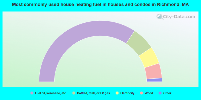
- 68.7%Fuel oil, kerosene, etc.
- 12.4%Bottled, tank, or LP gas
- 9.1%Electricity
- 7.9%Wood
- 1.4%Coal or coke
- 0.3%Other fuel
- 0.2%Utility gas
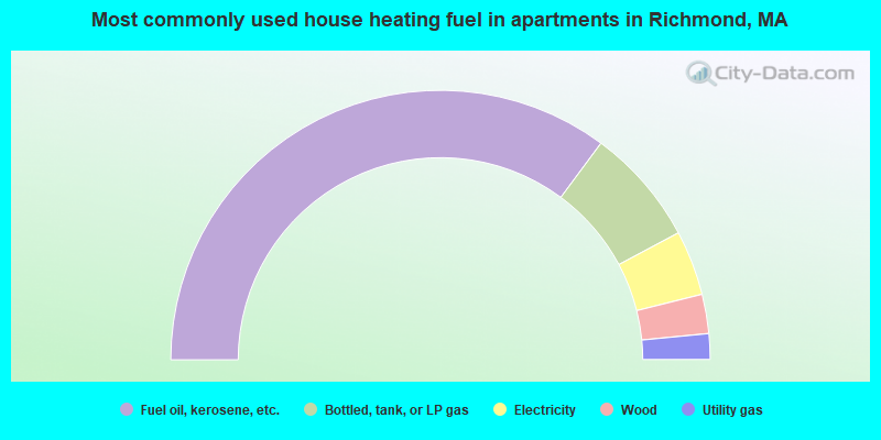
- 70.3%Fuel oil, kerosene, etc.
- 14.1%Bottled, tank, or LP gas
- 7.8%Electricity
- 4.7%Wood
- 3.1%Utility gas
Richmond compared to Massachusetts state average:
- Unemployed percentage significantly below state average.
- Black race population percentage significantly below state average.
- Hispanic race population percentage significantly below state average.
- Median age significantly above state average.
- Foreign-born population percentage significantly below state average.
- Renting percentage significantly below state average.
- Length of stay since moving in significantly above state average.
- Number of rooms per house significantly below state average.
- House age significantly below state average.

|
|
Total of 49 patent applications in 2008-2024.