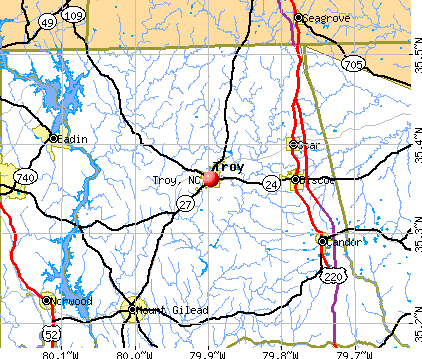
Troy, North Carolina
Submit your own pictures of this town and show them to the world
- OSM Map
- General Map
- Google Map
- MSN Map
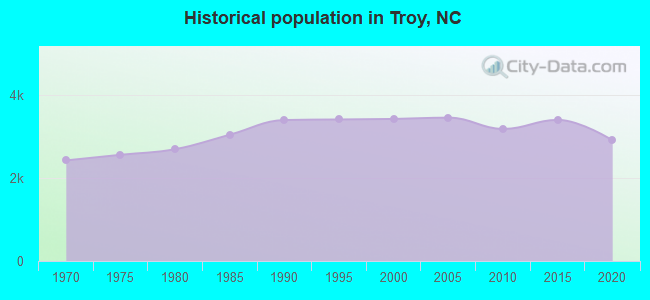
Population change since 2000: -14.1%
 |
| Males: 1,550 | |
| Females: 1,395 |
| Median resident age: | 41.0 years |
| North Carolina median age: | 39.2 years |
Zip codes: 27371.
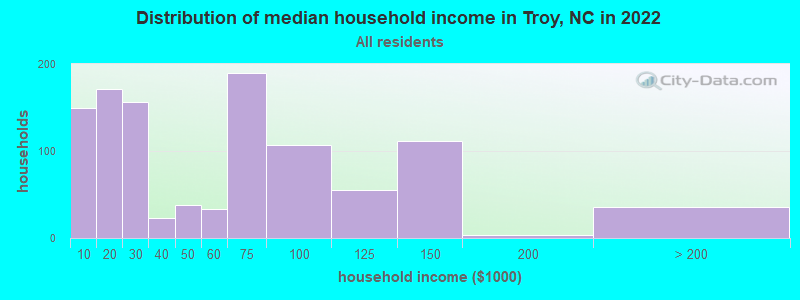
| Troy: | $45,127 |
| NC: | $67,481 |
Estimated per capita income in 2022: $23,795 (it was $11,420 in 2000)
Troy town income, earnings, and wages data
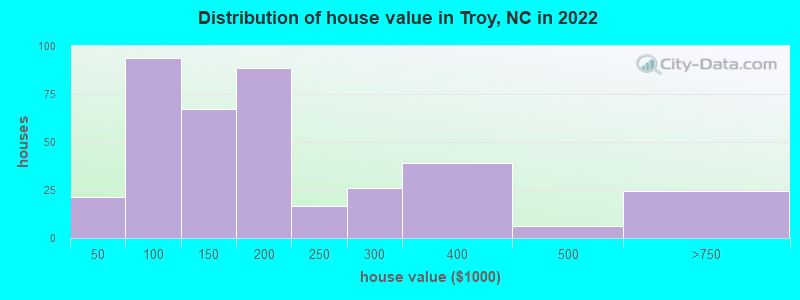
Estimated median house or condo value in 2022: $161,384 (it was $60,100 in 2000)
| Troy: | $161,384 |
| NC: | $280,600 |
Mean prices in 2022: all housing units: $188,617; detached houses: $203,159; mobile homes: $34,806
Median gross rent in 2022: $560.
(13.1% for White Non-Hispanic residents, 47.7% for Black residents)
Detailed information about poverty and poor residents in Troy, NC
Compare current foreclosures near Troy, NC:
| Photo | Address | Area | Beds / Baths | Price | Details |
|---|---|---|---|---|---|

|
#1
Correll Rd
Troy, NC 27371
|
1,458 sq. feet
|
- baths - beds |
show details | |

|
#2
Atkins Dairy Rd
Troy, NC 27371
|
2,180 sq. feet
|
- baths - beds |
show details | |

|
#3
Ivey St
Troy, NC 27371
|
- sq. feet
|
- baths - beds |
show details | |

|
#4
Bells Grove Rd
Denton, NC 27239
|
1,136 sq. feet
|
1 baths 2 beds |
show details | |

|
#5
Yadkin Brick Rd
New London, NC 28127
|
1,610 sq. feet
|
2 baths 3 beds |
show details | |

|
#6
Cherokee Ln
New London, NC 28127
|
1,900 sq. feet
|
2 baths 4 beds |
show details | |

|
#7
Plantation Way
Albemarle, NC 28001
|
1,365 sq. feet
|
2 baths 3 beds |
show details | |

|
#8
N 5th St
Albemarle, NC 28001
|
2,016 sq. feet
|
2 baths 3 beds |
show details | |

|
#9
Park Rd
Albemarle, NC 28001
|
1,360 sq. feet
|
1 baths 3 beds |
show details | |

|
#10
Rocky Ridge Rd
Seagrove, NC 27341
|
2,280 sq. feet
|
2 baths 4 beds |
show details |
| Photo | Address | Area | Beds / Baths | Price | Details |
|---|---|---|---|---|---|

|
#11
Old Whitney Rd
New London, NC 28127
|
2,871 sq. feet
|
3 baths 3 beds |
show details | |

|
#12
Dorilee Ln
Eagle Springs, NC 27242
|
2,079 sq. feet
|
2 baths 3 beds |
show details | |

|
#13
Vickers Store Rd
Albemarle, NC 28001
|
924 sq. feet
|
2 baths 3 beds |
show details | |

|
#14
Eastover Ave
Norwood, NC 28128
|
1,660 sq. feet
|
2 baths 4 beds |
show details | |

|
#15
Charles Mountain Rd
Denton, NC 27239
|
1,540 sq. feet
|
1 baths - beds |
show details | |

|
#16
Concord Church Rd
Ellerbe, NC 28338
|
1,792 sq. feet
|
2 baths - beds |
show details | |

|
#17
Ralph Lawrence Rd
Seagrove, NC 27341
|
2,310 sq. feet
|
2 baths - beds |
show details | |

|
#18
Nc Highway 134
Asheboro, NC 27205
|
1,664 sq. feet
|
2 baths - beds |
show details | |

|
#19
Seagrove Plank Rd
Asheboro, NC 27205
|
1,291 sq. feet
|
2 baths - beds |
show details | |

|
#20
Capel Mill Rd
Candor, NC 27229
|
- sq. feet
|
- baths - beds |
show details |
| Photo | Address | Area | Beds / Baths | Price | Details |
|---|---|---|---|---|---|

|
#21
Nc Highway 24 27 E
Biscoe, NC 27209
|
1,236 sq. feet
|
- baths - beds |
show details | |

|
#22
Windblow Rd
Jackson Springs, NC 27281
|
- sq. feet
|
- baths - beds |
show details | |

|
#23
Family Cir
Candor, NC 27229
|
- sq. feet
|
- baths - beds |
show details | |

|
#24
Lantern Ct.
Mount Gilead, NC 27306
|
- sq. feet
|
- baths - beds |
show details | |

|
#25
Ether Rd
Star, NC 27356
|
1,288 sq. feet
|
- baths - beds |
show details | |

|
#26
Nc 705 Hwy
Robbins, NC 27325
|
- sq. feet
|
- baths - beds |
show details | |

|
#27
Nc Highway 134
Asheboro, NC 27205
|
- sq. feet
|
- baths - beds |
show details | |

|
#28
Liberty Hill Church Rd
Mount Gilead, NC 27306
|
- sq. feet
|
- baths - beds |
show details | |

|
#29
Pekin Rd
Candor, NC 27229
|
1,064 sq. feet
|
- baths - beds |
show details | |

|
#30
Bascom Chapel Rd
Robbins, NC 27325
|
- sq. feet
|
- baths - beds |
show details |
| Photo | Address | Area | Beds / Baths | Price | Details |
|---|---|---|---|---|---|

|
#31
Southpoint Ln
New London, NC 28127
|
- sq. feet
|
- baths - beds |
show details | |

|
#32
Pisgah Rd
Asheboro, NC 27205
|
- sq. feet
|
- baths - beds |
show details | |

|
#33
King Mtn Rd
Asheboro, NC 27205
|
- sq. feet
|
- baths - beds |
show details | |

|
#34
Windy Ln
Candor, NC 27229
|
1,976 sq. feet
|
- baths - beds |
show details | |

|
#35
Woodhaven Dr Apt 1102
Albemarle, NC 28001
|
- sq. feet
|
- baths - beds |
show details | |

|
#36
Eagle Springs Rd
Eagle Springs, NC 27242
|
- sq. feet
|
- baths - beds |
show details | |

|
#37
Big Oak Church Rd
Eagle Springs, NC 27242
|
- sq. feet
|
- baths - beds |
show details | |

|
#38
Dogwood Ln
Mount Gilead, NC 27306
|
- sq. feet
|
- baths - beds |
show details | |

|
#39
Capel Mill Rd
Candor, NC 27229
|
- sq. feet
|
- baths - beds |
show details | |

|
Check over 1 million property listings on Foreclosure.com!
|
browse all offers | |||


- 1,43648.1%White alone
- 1,24741.8%Black alone
- 1434.8%Hispanic
- 802.7%Two or more races
- 331.1%American Indian alone
- 90.3%Other race alone
- 50.2%Asian alone
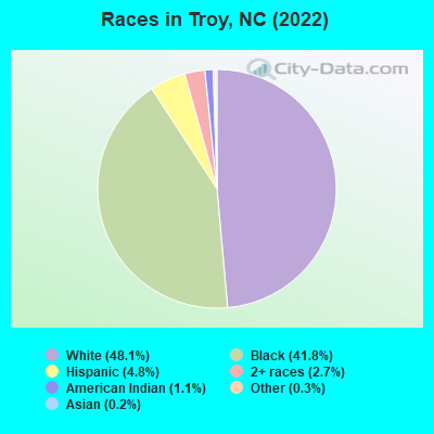
Races in Troy detailed stats: ancestries, foreign born residents, place of birth
According to our research of North Carolina and other state lists, there were 16 registered sex offenders living in Troy, North Carolina as of April 26, 2024.
The ratio of all residents to sex offenders in Troy is 219 to 1.
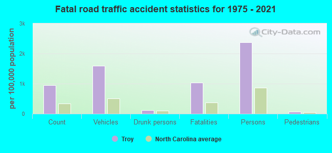
Type |
2009 |
2010 |
2011 |
2012 |
2013 |
2014 |
2015 |
2016 |
2017 |
2018 |
2019 |
2020 |
2021 |
2022 |
|---|---|---|---|---|---|---|---|---|---|---|---|---|---|---|
| Murders (per 100,000) | 0 (0.0) | 0 (0.0) | 0 (0.0) | 1 (31.2) | 0 (0.0) | 0 (0.0) | 0 (0.0) | 2 (58.6) | 0 (0.0) | 1 (30.5) | 0 (0.0) | 0 (0.0) | 3 (91.6) | 0 (0.0) |
| Rapes (per 100,000) | 3 (88.2) | 1 (31.4) | 0 (0.0) | 0 (0.0) | 0 (0.0) | 0 (0.0) | 1 (29.6) | 1 (29.3) | 0 (0.0) | 0 (0.0) | 0 (0.0) | 1 (31.3) | 1 (30.5) | 5 (171.5) |
| Robberies (per 100,000) | 3 (88.2) | 1 (31.4) | 0 (0.0) | 2 (62.3) | 1 (28.7) | 1 (28.9) | 3 (88.9) | 2 (58.6) | 1 (29.4) | 2 (61.1) | 3 (90.2) | 2 (62.6) | 1 (30.5) | 0 (0.0) |
| Assaults (per 100,000) | 8 (235.1) | 11 (344.9) | 19 (588.4) | 6 (187.0) | 13 (372.7) | 4 (115.7) | 8 (237.2) | 6 (175.9) | 5 (147.1) | 11 (335.9) | 16 (481.1) | 22 (688.8) | 23 (702.5) | 4 (137.2) |
| Burglaries (per 100,000) | 31 (911.0) | 25 (783.9) | 23 (712.3) | 15 (467.6) | 24 (688.1) | 27 (781.2) | 32 (948.7) | 26 (762.2) | 25 (735.5) | 18 (549.6) | 30 (902.0) | 35 (1,096) | 34 (1,038) | 10 (343.1) |
| Thefts (per 100,000) | 118 (3,468) | 92 (2,885) | 130 (4,026) | 95 (2,961) | 94 (2,695) | 57 (1,649) | 97 (2,876) | 49 (1,437) | 72 (2,118) | 63 (1,924) | 63 (1,894) | 84 (2,630) | 65 (1,985) | 41 (1,407) |
| Auto thefts (per 100,000) | 7 (205.7) | 6 (188.1) | 6 (185.8) | 7 (218.2) | 2 (57.3) | 3 (86.8) | 2 (59.3) | 3 (88.0) | 5 (147.1) | 0 (0.0) | 5 (150.3) | 11 (344.4) | 9 (274.9) | 2 (68.6) |
| Arson (per 100,000) | 2 (58.8) | 0 (0.0) | 0 (0.0) | 0 (0.0) | 2 (57.3) | 0 (0.0) | 0 (0.0) | 0 (0.0) | 0 (0.0) | 0 (0.0) | 0 (0.0) | 0 (0.0) | 0 (0.0) | 0 (0.0) |
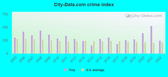
| City-Data.com crime index | 362.9 | 288.8 | 343.4 | 287.1 | 243.7 | 159.4 | 284.0 | 311.3 | 186.2 | 262.0 | 274.2 | 391.0 | 531.5 | 250.4 |
The City-Data.com crime index weighs serious crimes and violent crimes more heavily. Higher means more crime, U.S. average is 246.1. It adjusts for the number of visitors and daily workers commuting into cities.
Crime rate in Troy detailed stats: murders, rapes, robberies, assaults, burglaries, thefts, arson
Full-time law enforcement employees in 2021, including police officers: 10 (9 officers - 7 male; 2 female).
| Officers per 1,000 residents here: | 2.75 |
| North Carolina average: | 2.27 |
 Recent articles from our blog. Our writers, many of them Ph.D. graduates or candidates, create easy-to-read articles on a wide variety of topics.

 | NC and the US Census (279 replies) |
| Traffic and commute to Troy (5 replies) |
| Where should I move to attend school in Troy? (21 replies) |
| Relocating to the Troy NC area from CA (2 replies) |
| Anyone move from Upstate NY or Downstate IL to NC (22 replies) |
| The "Moving to Charlotte" Club (679 replies) |
Latest news from Troy, NC collected exclusively by city-data.com from local newspapers, TV, and radio stations
Troy, NC City Guides:
Ancestries: American (12.9%), English (7.0%), Scotch-Irish (4.3%), Liberian (4.2%), European (3.7%), African (2.9%).
Current Local Time: EST time zone
Elevation: 550 feet
Land area: 2.97 square miles.
Population density: 993 people per square mile (low).
83 residents are foreign born (1.7% Latin America, 0.8% Europe).
| This town: | 2.8% |
| North Carolina: | 8.3% |
Median real estate property taxes paid for housing units with mortgages in 2022: $930 (0.7%)
Median real estate property taxes paid for housing units with no mortgage in 2022: $1,264 (0.7%)
Nearest city with pop. 50,000+: Concord, NC  (39.8 miles , pop. 55,977).
Nearest city with pop. 200,000+: Greensboro, NC (49.9 miles , pop. 223,891).
Nearest city with pop. 1,000,000+: Philadelphia, PA (412.8 miles , pop. 1,517,550).
Nearest cities:
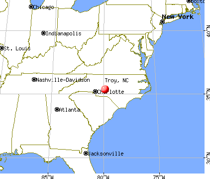
), ), Latitude: 35.36 N, Longitude: 79.90 W
Daytime population change due to commuting: +1,239 (+41.5%)
Workers who live and work in this town: 462 (39.9%)
Area code: 910
Troy, North Carolina accommodation & food services, waste management - Economy and Business Data
| Here: | 3.6% |
| North Carolina: | 3.2% |
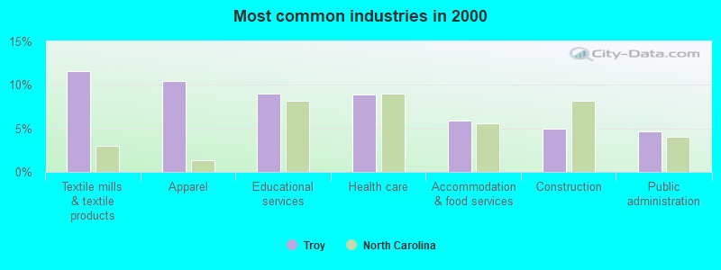
- Textile mills & textile products (11.6%)
- Apparel (10.4%)
- Educational services (9.0%)
- Health care (8.9%)
- Accommodation & food services (5.9%)
- Construction (5.0%)
- Public administration (4.7%)
- Textile mills & textile products (10.2%)
- Construction (9.0%)
- Apparel (8.1%)
- Public administration (6.6%)
- Educational services (6.2%)
- Furniture & related product manufacturing (4.3%)
- Wood products (3.9%)
- Health care (16.6%)
- Textile mills & textile products (13.1%)
- Apparel (12.9%)
- Educational services (11.9%)
- Accommodation & food services (8.2%)
- Social assistance (5.7%)
- Public administration (2.7%)
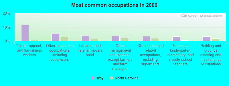
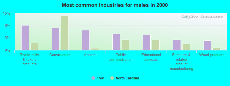
- Textile, apparel, and furnishings workers (11.6%)
- Other production occupations, including supervisors (5.7%)
- Laborers and material movers, hand (4.0%)
- Other management occupations, except farmers and farm managers (3.7%)
- Other sales and related occupations, including supervisors (3.5%)
- Preschool, kindergarten, elementary, and middle school teachers (3.4%)
- Building and grounds cleaning and maintenance occupations (3.3%)
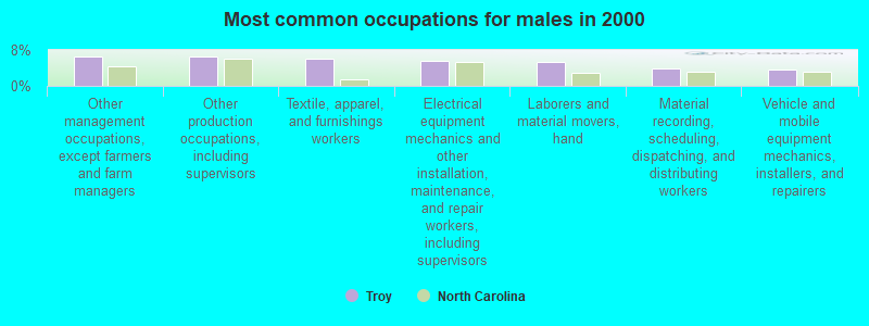
- Other management occupations, except farmers and farm managers (6.6%)
- Other production occupations, including supervisors (6.6%)
- Textile, apparel, and furnishings workers (6.0%)
- Electrical equipment mechanics and other installation, maintenance, and repair workers, including supervisors (5.6%)
- Laborers and material movers, hand (5.3%)
- Material recording, scheduling, dispatching, and distributing workers (3.9%)
- Vehicle and mobile equipment mechanics, installers, and repairers (3.6%)
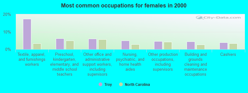
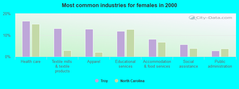
- Textile, apparel, and furnishings workers (17.4%)
- Preschool, kindergarten, elementary, and middle school teachers (6.2%)
- Other office and administrative support workers, including supervisors (6.1%)
- Nursing, psychiatric, and home health aides (4.9%)
- Other production occupations, including supervisors (4.7%)
- Building and grounds cleaning and maintenance occupations (4.5%)
- Cashiers (3.9%)
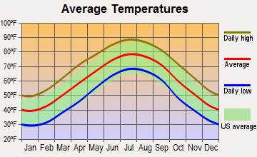
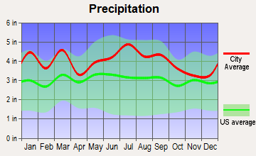
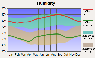
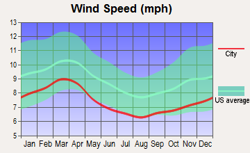
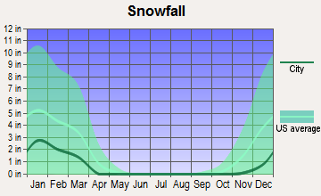
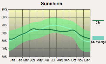
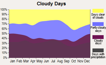
Average climate in Troy, North Carolina
Based on data reported by over 4,000 weather stations
|
|

(lower is better)
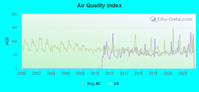
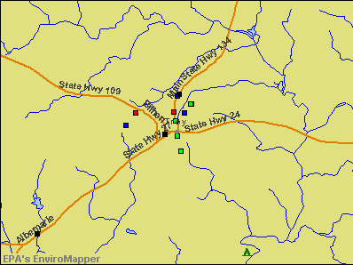
Air Quality Index (AQI) level in 2023 was 85.3. This is about average.
| City: | 85.3 |
| U.S.: | 72.6 |
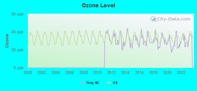
Ozone [ppb] level in 2023 was 33.4. This is about average. Closest monitor was 7.5 miles away from the city center.
| City: | 33.4 |
| U.S.: | 33.3 |
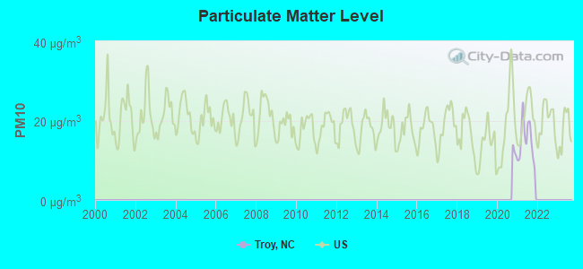
Particulate Matter (PM10) [µg/m3] level in 2021 was 15.0. This is better than average. Closest monitor was 7.5 miles away from the city center.
| City: | 15.0 |
| U.S.: | 19.2 |
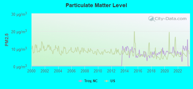
Particulate Matter (PM2.5) [µg/m3] level in 2022 was 7.41. This is about average. Closest monitor was 7.5 miles away from the city center.
| City: | 7.41 |
| U.S.: | 8.11 |
Tornado activity:
Troy-area historical tornado activity is slightly above North Carolina state average. It is 2% greater than the overall U.S. average.
On 10/7/1965, a category F3 (max. wind speeds 158-206 mph) tornado 20.4 miles away from the Troy town center killed one person and injured 4 people and caused between $5000 and $50,000 in damages.
On 5/5/1989, a category F4 (max. wind speeds 207-260 mph) tornado 41.1 miles away from the town center killed one person and injured 6 people and caused between $5,000,000 and $50,000,000 in damages.
Earthquake activity:
Troy-area historical earthquake activity is significantly above North Carolina state average. It is 38% smaller than the overall U.S. average.On 8/23/2011 at 17:51:04, a magnitude 5.8 (5.8 MW, Depth: 3.7 mi, Class: Moderate, Intensity: VI - VII) earthquake occurred 207.2 miles away from the city center
On 8/9/2020 at 12:07:37, a magnitude 5.1 (5.1 MW, Depth: 4.7 mi) earthquake occurred 102.2 miles away from the city center
On 8/2/1974 at 08:52:09, a magnitude 4.9 (4.3 MB, 4.9 LG, Class: Light, Intensity: IV - V) earthquake occurred 179.9 miles away from the city center
On 11/22/1974 at 05:25:55, a magnitude 4.7 (4.7 MB) earthquake occurred 170.8 miles away from the city center
On 7/27/1980 at 18:52:21, a magnitude 5.2 (5.1 MB, 4.7 MS, 5.0 UK, 5.2 UK) earthquake occurred 298.2 miles away from Troy center
On 8/21/1992 at 16:31:55, a magnitude 4.4 (4.1 MB, 4.1 LG, 4.4 LG, Depth: 6.2 mi) earthquake occurred 160.3 miles away from the city center
Magnitude types: regional Lg-wave magnitude (LG), body-wave magnitude (MB), surface-wave magnitude (MS), moment magnitude (MW)
Natural disasters:
The number of natural disasters in Montgomery County (16) is near the US average (15).Major Disasters (Presidential) Declared: 8
Emergencies Declared: 5
Causes of natural disasters: Hurricanes: 8, Droughts: 2, Blizzard: 1, Flood: 1, Freeze: 1, Ice Storm: 1, Storm: 1, Tropical Storm: 1, Winter Storm: 1, Other: 1 (Note: some incidents may be assigned to more than one category).

Main business address for: FIRST BANCORP /NC/ (STATE COMMERCIAL BANKS).
Hospitals and medical centers in Troy:
- FIRSTHEALTH MONTGOMERY MEMORIAL HOSP (Voluntary non-profit - Private, provides emergency services, 520 ALLEN STREET)
- HOME CARE OF THE CAROLINAS (707 ALBEMARLE ROAD SUITE 2)
Other hospitals and medical centers near Troy:
- AUTUMN CARE OF BISCOE (Nursing Home, about 7 miles away; BISCOE, NC)
- DIALYSIS CARE OF MONTGOMERY COUNTY INC (Dialysis Facility, about 7 miles away; BISCOE, NC)
- MT GILEAD CHILDREN'S HOME (Hospital, about 12 miles away; MOUNT GILEAD, NC)
- MYRTLEWOOD GROUP HOME (Hospital, about 12 miles away; MOUNT GILEAD, NC)
- FORREST OAKES HEALTHCARE CENTER (Nursing Home, about 15 miles away; ALBEMARLE, NC)
- ROBERT W THOMPSON GROUP HOME (Hospital, about 15 miles away; ALBEMARLE, NC)
- MARIE G. SMITH GROUP HOME (Hospital, about 15 miles away; ALBEMARLE, NC)
Heliports located in Troy:
College/University in Troy:
Colleges/universities with over 2000 students nearest to Troy:
- Stanly Community College (about 20 miles; Albemarle, NC; Full-time enrollment: 2,307)
- Randolph Community College (about 22 miles; Asheboro, NC; FT enrollment: 2,528)
- Sandhills Community College (about 29 miles; Pinehurst, NC; FT enrollment: 3,434)
- Richmond Community College (about 34 miles; Hamlet, NC; FT enrollment: 2,106)
- Rowan-Cabarrus Community College (about 39 miles; Salisbury, NC; FT enrollment: 5,749)
- Davidson County Community College (about 39 miles; Thomasville, NC; FT enrollment: 3,581)
- Wingate University (about 41 miles; Wingate, NC; FT enrollment: 2,125)
Public high school in Troy:
- MONTGOMERY LEARNING ACADEMY (Location: 310 S MAIN, Grades: 6-12)
Private high schools in Troy:
Public elementary/middle schools in Troy:
- TROY ELEMENTARY (Location: 310 N RUSSELL ST, Grades: PK-2)
- PAGE STREET ELEMENTARY (Location: 897 PAGE STREET, Grades: 3-5)
Points of interest:
Notable location: Troy City Hall (A). Display/hide its location on the map
Main business address in Troy: FIRST BANCORP /NC/ (A). Display/hide its location on the map
Church in Troy: Trinity Church (A). Display/hide its location on the map
Cemetery: Southside Cemetery (1). Display/hide its location on the map
Courts: State Of North Carolina - Magistrate Office (Court House), State Of North Carolina - District Court Counselor (Court House).
Birthplace of: Henry F. Warner - Army Medal of Honor recipient.
Drinking water stations with addresses in Troy and their reported violations in the past:
LAUREL HILL BAPTIST CHURCH (Population served: 75, Groundwater):Past health violations:Past monitoring violations:
- MCL, Monthly (TCR) - In MAR-2005, Contaminant: Coliform. Follow-up actions: St Formal NOV issued (MAR-09-2005), St Public Notif requested (MAR-09-2005), St Compliance achieved (JUN-11-2010), St Intentional no-action (JUN-11-2010)
- Monitoring, Repeat Major (TCR) - Between APR-2008 and JUN-2008, Contaminant: Coliform (TCR). Follow-up actions: St Public Notif requested (OCT-29-2008), St Formal NOV issued (OCT-29-2008), St Compliance achieved (AUG-30-2010)
- 2 routine major monitoring violations
- One regular monitoring violation
Drinking water stations with addresses in Troy that have no violations reported:
- LONG HILL BAPTIST CHURCH (Population served: 125, Primary Water Source Type: Groundwater)
| This town: | 2.4 people |
| North Carolina: | 2.5 people |
| This town: | 63.1% |
| Whole state: | 66.7% |
| This town: | 5.2% |
| Whole state: | 5.9% |
Likely homosexual households (counted as self-reported same-sex unmarried-partner households)
- Lesbian couples: 0.2% of all households
- Gay men: 0.2% of all households
6 people in residential treatment centers for adults in 2010
People in group quarters in Troy in 2000:
- 740 people in state prisons
- 49 people in nursing homes
- 36 people in local jails and other confinement facilities (including police lockups)
- 2 people in other noninstitutional group quarters
Banks with branches in Troy (2011 data):
- First Bank: at 341 North Main Street, Montgomery Square Branch, Operations Branch. Info updated 2011/01/25: Bank assets: $3,289.4 mil, Deposits: $2,759.1 mil, local headquarters, positive income, Commercial Lending Specialization, 98 total offices, Holding Company: First Bancorp
- The Fidelity Bank: Troy Branch at 315 Albemarle Road, branch established on 1977/04/04. Info updated 2006/11/03: Bank assets: $1,422.4 mil, Deposits: $1,234.1 mil, headquarters in Fuquay Varina, NC, positive income, Commercial Lending Specialization, 66 total offices, Holding Company: Fidelity Bancshares (N.C.), Inc.
For population 15 years and over in Troy:
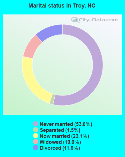
- Never married: 53.8%
- Now married: 23.1%
- Separated: 1.5%
- Widowed: 10.0%
- Divorced: 11.6%
For population 25 years and over in Troy:
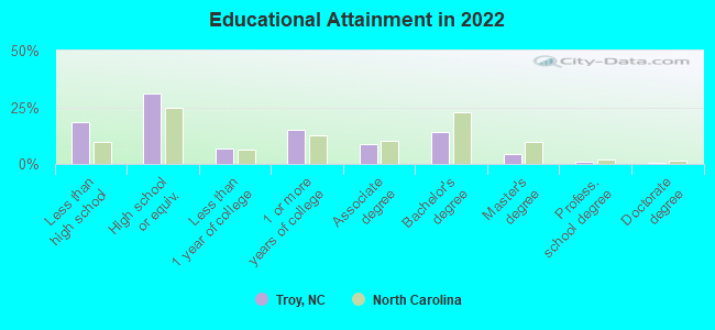
- High school or higher: 80.5%
- Bachelor's degree or higher: 18.6%
- Graduate or professional degree: 5.8%
- Unemployed: 5.8%
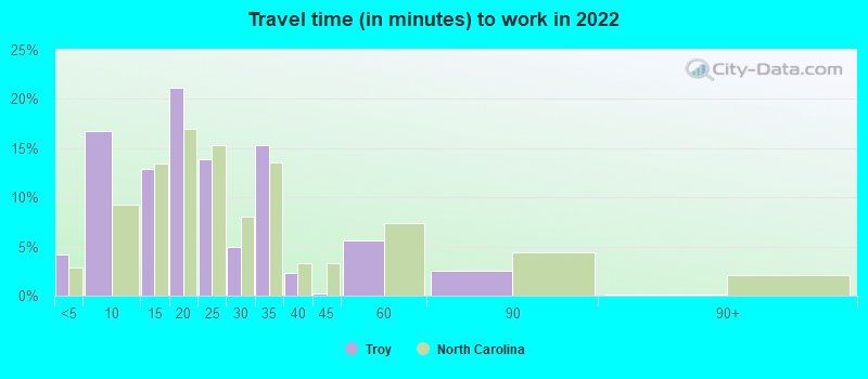
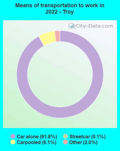
- Mean travel time to work (commute): 20.7 minutes
| Here: | 10.9 |
| North Carolina average: | 11.7 |
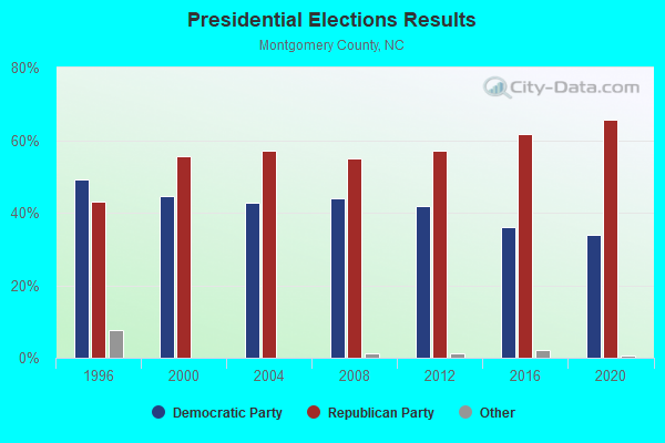
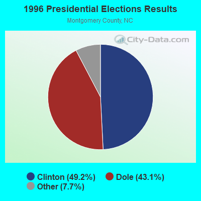
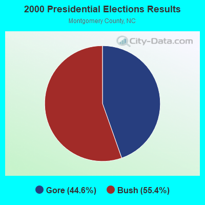
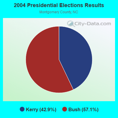
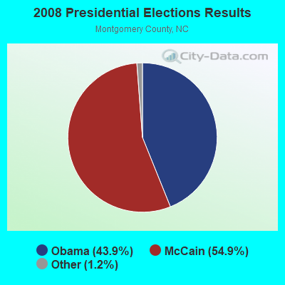
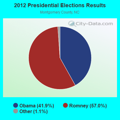

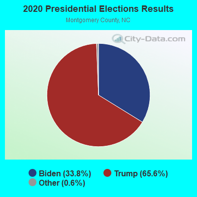
Graphs represent county-level data. Detailed 2008 Election Results
Religion statistics for Troy, NC (based on Montgomery County data)
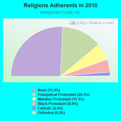
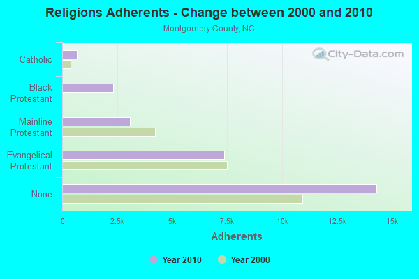
| Religion | Adherents | Congregations |
|---|---|---|
| Evangelical Protestant | 7,373 | 51 |
| Mainline Protestant | 3,087 | 29 |
| Black Protestant | 2,329 | 16 |
| Catholic | 681 | 1 |
| Orthodox | 56 | 1 |
| Other | 3 | 1 |
| None | 14,318 | - |
Food Environment Statistics:
| Montgomery County: | 1.46 / 10,000 pop. |
| North Carolina: | 2.05 / 10,000 pop. |
| Montgomery County: | 0.37 / 10,000 pop. |
| State: | 0.14 / 10,000 pop. |
| Here: | 0.73 / 10,000 pop. |
| North Carolina: | 0.92 / 10,000 pop. |
| Montgomery County: | 5.86 / 10,000 pop. |
| North Carolina: | 4.75 / 10,000 pop. |
| Montgomery County: | 4.03 / 10,000 pop. |
| North Carolina: | 7.57 / 10,000 pop. |
| Montgomery County: | 10.9% |
| North Carolina: | 9.8% |
| Montgomery County: | 30.8% |
| North Carolina: | 28.3% |
| Montgomery County: | 19.1% |
| North Carolina: | 15.6% |
Health and Nutrition:
| This city: | 47.3% |
| North Carolina: | 48.9% |
| This city: | 41.8% |
| North Carolina: | 46.1% |
| Troy: | 28.5 |
| North Carolina: | 28.8 |
| Here: | 18.7% |
| North Carolina: | 20.7% |
| Troy: | 11.6% |
| State: | 10.7% |
| Troy: | 6.7 |
| North Carolina: | 6.8 |
| Here: | 29.5% |
| North Carolina: | 33.7% |
| Troy: | 53.1% |
| North Carolina: | 55.8% |
| This city: | 79.7% |
| North Carolina: | 79.7% |
More about Health and Nutrition of Troy, NC Residents
| Local government employment and payroll (March 2022) | |||||
| Function | Full-time employees | Monthly full-time payroll | Average yearly full-time wage | Part-time employees | Monthly part-time payroll |
|---|---|---|---|---|---|
| Police Protection - Officers | 12 | $46,253 | $46,253 | 1 | $517 |
| Streets and Highways | 7 | $25,862 | $44,335 | 1 | $4,483 |
| Other and Unallocable | 4 | $18,385 | $55,155 | 43 | $29,321 |
| Other Government Administration | 4 | $11,664 | $34,992 | 0 | $0 |
| Financial Administration | 4 | $28,116 | $84,348 | 0 | $0 |
| Sewerage | 3 | $16,184 | $64,736 | 0 | $0 |
| Police - Other | 0 | $0 | 1 | $1,781 | |
| Totals for Government | 34 | $146,464 | $51,693 | 46 | $36,102 |
| Businesses in Troy, NC | ||||
| Name | Count | Name | Count | |
|---|---|---|---|---|
| Advance Auto Parts | 1 | Jones New York | 1 | |
| CVS | 1 | Lane Furniture | 2 | |
| FedEx | 1 | McDonald's | 1 | |
| Ford | 1 | Subway | 1 | |
| H&R Block | 1 | UPS | 4 | |
Strongest AM radio stations in Troy:
- WJRM (1390 AM; 1 kW; TROY, NC; Owner: FAMILY WORSHIP MINISTRIES, INC.)
- WTRU (830 AM; 50 kW; KERNERSVILLE, NC; Owner: TRUTH BROADCASTING CORPORATION)
- WPTF (680 AM; 50 kW; RALEIGH, NC; Owner: FIRST STATE COMMUNICATIONS)
- WBT (1110 AM; 50 kW; CHARLOTTE, NC; Owner: JEFFERSON-PILOT COMMUNICATNS CO. OF NORTH CAROLINA)
- WEEB (990 AM; 10 kW; SOUTHERN PINES, NC; Owner: PINEHURST BROADCASTING CORP.)
- WAGL (1560 AM; daytime; 50 kW; LANCASTER, SC; Owner: PALMETTO BROADCASTING SYSTEM, INC.)
- WLWL (770 AM; daytime; 5 kW; ROCKINGHAM, NC; Owner: SANDHILLS BROADCASTING CO., INC.)
- WFTK (1030 AM; daytime; 50 kW; WAKE FOREST, NC; Owner: POSITIVE RADIO GROUP, INC.)
- WCEO (840 AM; daytime; 50 kW; COLUMBIA, SC; Owner: EASTERN BROADCASTING GROUP, INC.)
- WKXR (1260 AM; 5 kW; ASHEBORO, NC; Owner: RANDOLPH BROADCASTING, INC.)
- WHKY (1290 AM; 50 kW; HICKORY, NC; Owner: LONG COMMUNICATIONS, LLC.)
- WNOW (1030 AM; daytime; 9 kW; MINT HILL, NC; Owner: CHARLOTTE METRO RADIO, INC.)
- WBAJ (890 AM; daytime; 50 kW; BLYTHEWOOD, SC; Owner: FAMILY FIRST)
Strongest FM radio stations in Troy:
- WMAG (99.5 FM; HIGH POINT, NC; Owner: CAPSTAR TX LIMITED PARTNERSHIP)
- WKRR (92.3 FM; ASHEBORO, NC; Owner: DICK BROADCASTING COMPANY, INC. OF TENNESSEE)
- WTJY (89.5 FM; ASHEBORO, NC; Owner: POSITIVE ALTERNATIVE RADIO, INC.)
- WYFQ-FM (93.5 FM; WADESBORO, NC; Owner: BIBLE BROADCASTING NETWORK, INC.)
- WQMG-FM (97.1 FM; GREENSBORO, NC; Owner: ENTERCOM GREENSBORO LICENSE, LLC)
- WFAE (90.7 FM; CHARLOTTE, NC; Owner: UNIVERSITY RADIO FOUNDATION, INC.)
- WOZN (98.7 FM; GREENSBORO, NC; Owner: ENTERCOM GREENSBORO LICENSE, LLC)
- WABZ-FM (100.9 FM; ALBEMARLE, NC; Owner: SUSQUEHANNA RADIO CORP.)
- WWMG (96.1 FM; SHELBY, NC; Owner: CLEAR CHANNEL BROADCASTING LICENSES, INC.)
- WSOC-FM (103.7 FM; CHARLOTTE, NC; Owner: INFINITY RADIO SUBSIDIARY OPERATIONS INC.)
- WSSS (104.7 FM; CHARLOTTE, NC; Owner: INFINITY RADIO SUBSIDIARY OPERATIONS INC.)
- WVBZ (100.3 FM; HIGH POINT, NC; Owner: CAPSTAR TX LIMITED PARTNERSHIP)
- WTHZ (94.1 FM; LEXINGTON, NC; Owner: DAVIDSON COUNTY BROADCASTING CO, INC)
- WKXU (101.1 FM; BURLINGTON, NC; Owner: CAROLINA RADIO GROUP, INC.)
- WIOZ-FM (102.5 FM; SOUTHERN PINES, NC; Owner: MERIDIAN COMMUNICATIONS. L.L.C.)
- WBFY (90.3 FM; PINEHURST, NC; Owner: AMERICAN FAMILY ASSOCIATION)
TV broadcast stations around Troy:
- WFMY-TV (Channel 2; GREENSBORO, NC; Owner: WFMY TELEVISION CORPORATION)
- WUPN-TV (Channel 48; GREENSBORO, NC; Owner: WUPN LICENSEE, LLC)
- WXLV-TV (Channel 45; WINSTON-SALEM, NC; Owner: WXLV LICENSEE, LLC)
- WTWB-TV (Channel 20; LEXINGTON, NC; Owner: WTWB OF THE TRIAD, LLC)
- WLXI-TV (Channel 61; GREENSBORO, NC; Owner: TRI-STATE CHRISTIAN TV, INC.)
- W29BC (Channel 29; BISCOE, NC; Owner: WCNC-TV, INC.)
- WGHP (Channel 8; HIGH POINT, NC; Owner: WGHP LICENSE, INC.)
- WUNG-TV (Channel 58; CONCORD, NC; Owner: UNIVERSITY OF NORTH CAROLINA)
- WAXN (Channel 64; KANNAPOLIS, NC; Owner: WSOC-TV HOLDINGS, INC.)
- WUVC (Channel 40; FAYETTEVILLE, NC; Owner: CAPITAL BROADCASTING PARTNERS)
- WAFF (Channel 48; HUNTSVILLE, AL; Owner: RAYCOM AMERICA, INC.)
- WGTB-LP (Channel 28; CHARLOTTE, NC; Owner: VICTORY CHRISTIAN CENTER, INC.)
- WTVI (Channel 42; CHARLOTTE, NC; Owner: CHARLOTTE-MECKLENBURG PUBLIC BROADCASTING AUTHORITY)
Medal of Honor Recipients
Medal of Honor Recipient born in Troy: Henry F. Warner.
- National Bridge Inventory (NBI) Statistics
- 31Number of bridges
- 371ft / 113mTotal length
- 74,970Total average daily traffic
- 6,082Total average daily truck traffic
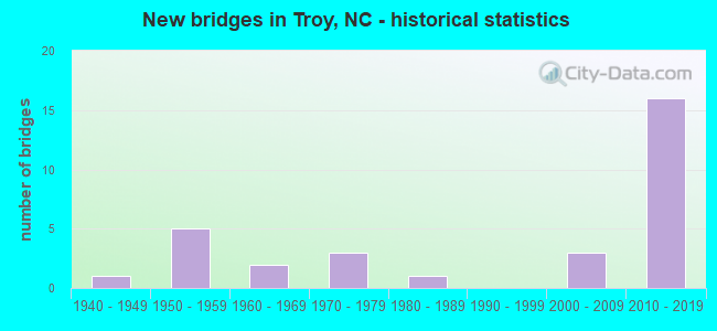
- New bridges - historical statistics
- 11940-1949
- 51950-1959
- 21960-1969
- 31970-1979
- 11980-1989
- 32000-2009
- 162010-2019
FCC Registered Cell Phone Towers:
3 (See the full list of FCC Registered Cell Phone Towers in Troy)FCC Registered Antenna Towers:
53 (See the full list of FCC Registered Antenna Towers)FCC Registered Commercial Land Mobile Towers:
1 (See the full list of FCC Registered Commercial Land Mobile Towers in Troy, NC)FCC Registered Private Land Mobile Towers:
1 (See the full list of FCC Registered Private Land Mobile Towers)FCC Registered Broadcast Land Mobile Towers:
21 (See the full list of FCC Registered Broadcast Land Mobile Towers)FCC Registered Microwave Towers:
45 (See the full list of FCC Registered Microwave Towers in this town)FCC Registered Amateur Radio Licenses:
29 (See the full list of FCC Registered Amateur Radio Licenses in Troy)FAA Registered Aircraft:
6- Aircraft: CESSNA 177 (Category: Land, Seats: 4, Weight: Up to 12,499 Pounds, Speed: 108 mph), Engine: LYCOMING O-360-A1A (180 HP) (Reciprocating)
N-Number: 2249Y, N2249Y, N-2249Y, Serial Number: 17700049, Year manufactured: 1967, Airworthiness Date: 10/29/2008, Certificate Issue Date: 08/19/2008
Registrant (Individual): Bernie E Blake, 3796 River Rd, Troy, NC 27371 - Aircraft: HARRIS D W II CAPELLA FW2C80TRXLS (Category: Land, Seats: 2, Weight: Up to 12,499 Pounds), Engine: BOMBARDIER ROTAX (ALL) (Reciprocating)
N-Number: 41WH, N41WH, N-41WH, Serial Number: 07995002, Airworthiness Date: 12/09/1997, Certificate Issue Date: 08/27/2019
Registrant (Individual): Bernie E Blake, 3796 River Rd, Troy, NC 27371 - Aircraft: DUCAR MICHAEL J JDT 1400Z HI-MAX (Category: Land, Weight: Up to 12,499 Pounds), Engine: AMA/EXPR UNKNOWN ENG (2 Cycle)
N-Number: 541MD, N541MD, N-541MD, Serial Number: 4808, Year manufactured: 2010, Airworthiness Date: 07/26/2010, Certificate Issue Date: 05/10/2017
Registrant (Individual): Bernie E Blake, 3796 River Rd, Troy, NC 27371 - Aircraft: TALBERT BILLY L BAKENG DEUCE (Category: Land, Seats: 2, Weight: Up to 12,499 Pounds), Engine: LYCOMING O-290-D2 (140 HP) (Reciprocating)
N-Number: 343FT, N343FT, N-343FT, Serial Number: 101, Year manufactured: 2011, Airworthiness Date: 07/12/2011, Certificate Issue Date: 06/19/2008
Registrant (Individual): Billy L Talbert, 455 Warner Rd, Troy, NC 27371
Deregistered: Cancel Date: 03/22/2018 - Aircraft: PIPER J3C-65 (Category: Land, Seats: 2, Weight: Up to 12,499 Pounds, Speed: 67 mph), Engine: CONT MOTOR A&C65 SERIES (65 HP) (Reciprocating)
N-Number: 42969, N42969, N-42969, Serial Number: 15328, Year manufactured: 1946, Airworthiness Date: 05/25/1956, Certificate Issue Date: 04/14/2014
Registrant (Individual): Billy G Bowman, 600 Green Gap Shrs, Troy, NC 27371
Deregistered: Cancel Date: 03/22/2018 - Aircraft: PIPER PA-15 (Category: Land, Seats: 2, Weight: Up to 12,499 Pounds, Speed: 75 mph), Engine: LYCOMING 0-145B SERIES (65 HP) (Reciprocating)
N-Number: 4428H, N4428H, N-4428H, Serial Number: 15-213, Year manufactured: 1948, Airworthiness Date: 11/05/1957, Certificate Issue Date: 04/14/2014
Registrant (Individual): Billy G Bowman, 600 Green Gap Shrs, Troy, NC 27371
Deregistered: Cancel Date: 03/23/2018
2002 - 2018 National Fire Incident Reporting System (NFIRS) incidents
- Fire incident types reported to NFIRS in Troy, NC
- 21943.8%Outside Fires
- 15731.4%Structure Fires
- 7014.0%Other
- 5410.8%Mobile Property/Vehicle Fires
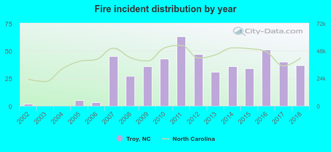 According to the data from the years 2002 - 2018 the average number of fire incidents per year is 29. The highest number of fire incidents - 63 took place in 2011, and the least - 0 in 2003. The data has a rising trend.
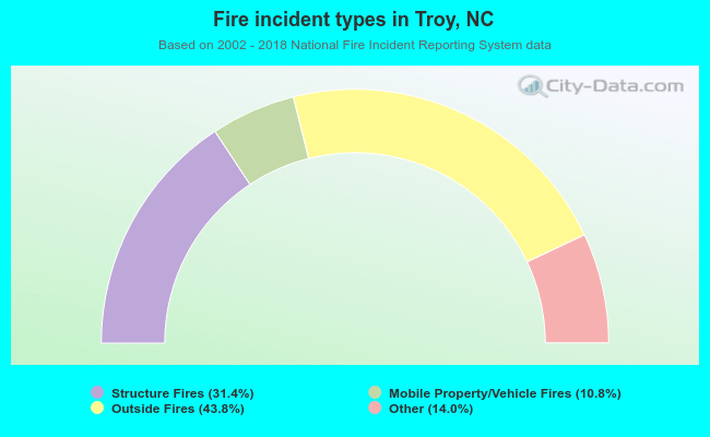 When looking into fire subcategories, the most incidents belonged to: Outside Fires (43.8%), and Structure Fires (31.4%).
| Most common first names in Troy, NC among deceased individuals | ||
| Name | Count | Lived (average) |
|---|---|---|
| James | 77 | 72.3 years |
| John | 65 | 73.9 years |
| William | 64 | 70.9 years |
| Mary | 58 | 78.2 years |
| Robert | 30 | 68.0 years |
| Charles | 21 | 70.8 years |
| George | 21 | 79.0 years |
| Charlie | 18 | 78.7 years |
| Ruth | 17 | 75.9 years |
| Minnie | 17 | 79.5 years |
| Most common last names in Troy, NC among deceased individuals | ||
| Last name | Count | Lived (average) |
|---|---|---|
| Morris | 50 | 78.5 years |
| Russell | 48 | 81.7 years |
| Saunders | 34 | 71.7 years |
| Cranford | 33 | 72.2 years |
| Hurley | 32 | 79.5 years |
| Thompson | 32 | 71.0 years |
| Brown | 29 | 74.5 years |
| Smith | 29 | 71.9 years |
| Harris | 27 | 68.6 years |
| Morton | 26 | 72.0 years |
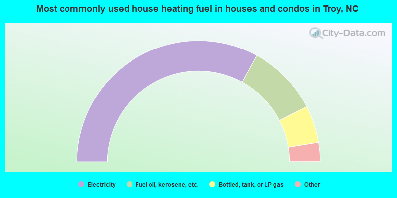
- 66.1%Electricity
- 19.1%Fuel oil, kerosene, etc.
- 9.9%Bottled, tank, or LP gas
- 1.4%Utility gas
- 1.4%Other fuel
- 1.2%No fuel used
- 0.9%Wood
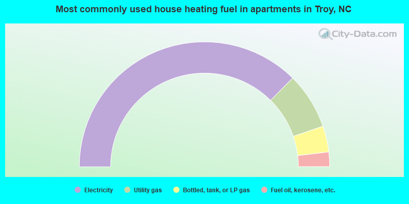
- 74.9%Electricity
- 14.6%Utility gas
- 6.7%Bottled, tank, or LP gas
- 3.8%Fuel oil, kerosene, etc.
Troy compared to North Carolina state average:
- Median house value below state average.
- Unemployed percentage below state average.
- Black race population percentage above state average.
- Hispanic race population percentage below state average.
- Median age significantly below state average.
- Foreign-born population percentage significantly below state average.
- Renting percentage above state average.
- Length of stay since moving in significantly above state average.
- House age above state average.
- Institutionalized population percentage significantly above state average.
Troy on our top lists:
- #21 on the list of "Top 100 cities with the largest percentage of females"
- #100 (27371) on the list of "Top 101 zip codes with the largest percentage of Scotch-Irish first ancestries (pop 5,000+)"
- #14 on the list of "Top 101 counties with the lowest Particulate Matter (PM10) Annual air pollution readings in 2012 (µg/m3)"

|
|
Total of 8 patent applications in 2008-2024.