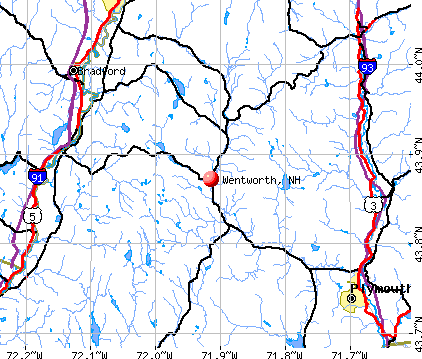
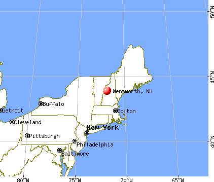
Wentworth, New Hampshire
Submit your own pictures of this town and show them to the world
- OSM Map
- General Map
- Google Map
- MSN Map
Population change since 2000: +14.2%
 |
| Males: 459 | |
| Females: 452 |
| Median resident age: | 47.3 years |
| New Hampshire median age: | 43.9 years |
Zip codes: 03282.
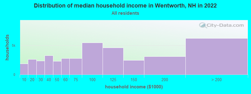
| Wentworth: | $86,458 |
| NH: | $89,992 |
Estimated per capita income in 2022: $41,519 (it was $18,258 in 2000)
Wentworth town income, earnings, and wages data
Estimated median house or condo value in 2022: $318,344 (it was $99,600 in 2000)
| Wentworth: | $318,344 |
| NH: | $384,700 |
Mean prices in 2022: all housing units: $486,096; detached houses: $533,852; townhouses or other attached units: $375,744; in 2-unit structures: $230,260; in 3-to-4-unit structures: $242,363; in 5-or-more-unit structures: $588,257; mobile homes: $127,035
Detailed information about poverty and poor residents in Wentworth, NH


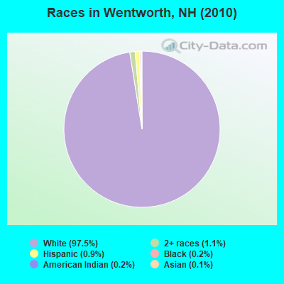
- 88897.5%White alone
- 101.1%Two or more races
- 80.9%Hispanic
- 20.2%Black alone
- 20.2%American Indian alone
- 10.1%Asian alone
Races in Wentworth detailed stats: ancestries, foreign born residents, place of birth
According to our research of New Hampshire and other state lists, there was 1 registered sex offender living in Wentworth, New Hampshire as of April 26, 2024.
The ratio of all residents to sex offenders in Wentworth is 911 to 1.
The ratio of registered sex offenders to all residents in this city is lower than the state average.
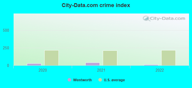
Type |
2020 |
2021 |
2022 |
|---|---|---|---|
| Murders (per 100,000) | 0 (0.0) | 0 (0.0) | 0 (0.0) |
| Rapes (per 100,000) | 0 (0.0) | 0 (0.0) | 0 (0.0) |
| Robberies (per 100,000) | 0 (0.0) | 0 (0.0) | 0 (0.0) |
| Assaults (per 100,000) | 0 (0.0) | 0 (0.0) | 0 (0.0) |
| Burglaries (per 100,000) | 2 (205.8) | 0 (0.0) | 0 (0.0) |
| Thefts (per 100,000) | 4 (411.5) | 8 (813.8) | 3 (350.5) |
| Auto thefts (per 100,000) | 0 (0.0) | 1 (101.7) | 0 (0.0) |
| Arson (per 100,000) | 0 (0.0) | 0 (0.0) | 0 (0.0) |
| City-Data.com crime index | 30.9 | 40.7 | 14.0 |
The City-Data.com crime index weighs serious crimes and violent crimes more heavily. Higher means more crime, U.S. average is 246.1. It adjusts for the number of visitors and daily workers commuting into cities.
Crime rate in Wentworth detailed stats: murders, rapes, robberies, assaults, burglaries, thefts, arson
 Recent articles from our blog. Our writers, many of them Ph.D. graduates or candidates, create easy-to-read articles on a wide variety of topics.

 | Cell Service in the Wentworth, Plymouth, Warren NH area (8 replies) |
| Looking for Brad, Rumney NH (2 replies) |
| Wakefield and Wentworth (7 replies) |
| Mountain house areas? (10 replies) |
| Can you recommend a place in NH for a 30 year old single man? (42 replies) |
| Retire to NH - thoughts? (29 replies) |
Latest news from Wentworth, NH collected exclusively by city-data.com from local newspapers, TV, and radio stations
Ancestries: English (25.3%), French (20.4%), Irish (12.3%), German (8.6%), Scottish (8.4%), United States (7.8%).
Current Local Time: EST time zone
Incorporated in 1766
Elevation: 689 feet
Land area: 41.7 square miles.
Population density: 22 people per square mile (very low).
18 residents are foreign born (0.8% Asia, 0.8% North America, 0.5% Europe, 0.3% Latin America).
| This town: | 2.3% |
| New Hampshire: | 4.4% |
| Wentworth town: | 1.6% ($1,581) |
| New Hampshire: | 2.3% ($2,946) |
Nearest city with pop. 50,000+: Manchester, NH  (64.8 miles , pop. 107,006).
Nearest city with pop. 200,000+: Boston, MA (114.3 miles , pop. 589,141).
Nearest city with pop. 1,000,000+: Bronx, NY (230.9 miles , pop. 1,332,650).
Nearest cities:
), ), ), )Latitude: 43.86 N, Longitude: 71.92 W
Area code commonly used in this area: 603

| Here: | 2.7% |
| New Hampshire: | 2.5% |
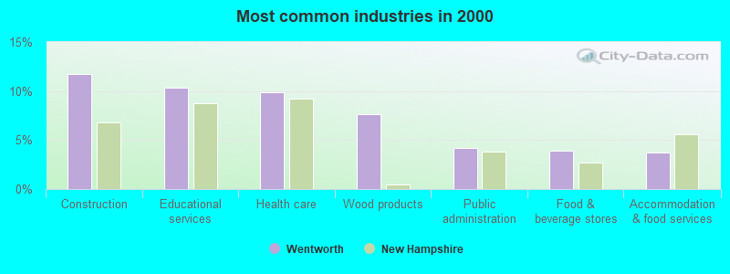
- Construction (11.8%)
- Educational services (10.4%)
- Health care (9.9%)
- Wood products (7.6%)
- Public administration (4.1%)
- Food & beverage stores (3.9%)
- Accommodation & food services (3.7%)
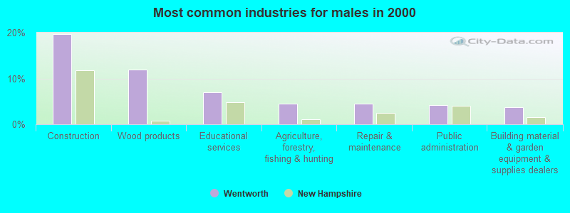
- Construction (19.8%)
- Wood products (11.9%)
- Educational services (7.0%)
- Agriculture, forestry, fishing & hunting (4.5%)
- Repair & maintenance (4.5%)
- Public administration (4.1%)
- Building material & garden equipment & supplies dealers (3.7%)
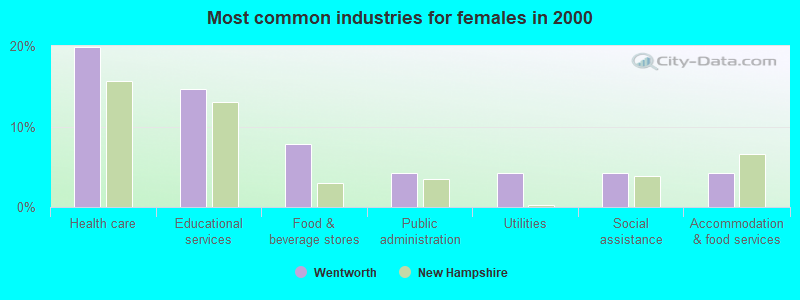
- Health care (19.9%)
- Educational services (14.7%)
- Food & beverage stores (7.9%)
- Public administration (4.2%)
- Utilities (4.2%)
- Social assistance (4.2%)
- Accommodation & food services (4.2%)
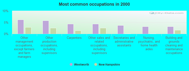
- Other management occupations, except farmers and farm managers (6.2%)
- Other production occupations, including supervisors (5.8%)
- Carpenters (4.4%)
- Other sales and related occupations, including supervisors (4.4%)
- Secretaries and administrative assistants (3.7%)
- Nursing, psychiatric, and home health aides (3.2%)
- Building and grounds cleaning and maintenance occupations (3.2%)
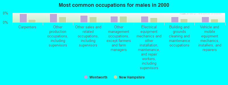
- Carpenters (7.4%)
- Other production occupations, including supervisors (7.4%)
- Other sales and related occupations, including supervisors (6.2%)
- Other management occupations, except farmers and farm managers (5.3%)
- Electrical equipment mechanics and other installation, maintenance, and repair workers, including supervisors (5.3%)
- Building and grounds cleaning and maintenance occupations (4.9%)
- Vehicle and mobile equipment mechanics, installers, and repairers (4.9%)
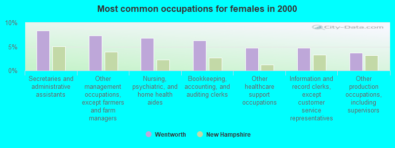
- Secretaries and administrative assistants (8.4%)
- Other management occupations, except farmers and farm managers (7.3%)
- Nursing, psychiatric, and home health aides (6.8%)
- Bookkeeping, accounting, and auditing clerks (6.3%)
- Other healthcare support occupations (4.7%)
- Information and record clerks, except customer service representatives (4.7%)
- Other production occupations, including supervisors (3.7%)
Average climate in Wentworth, New Hampshire
Based on data reported by over 4,000 weather stations


(lower is better)
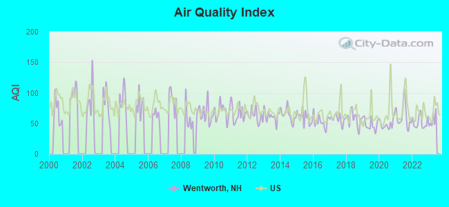
Air Quality Index (AQI) level in 2022 was 51.6. This is significantly better than average.
| City: | 51.6 |
| U.S.: | 72.6 |
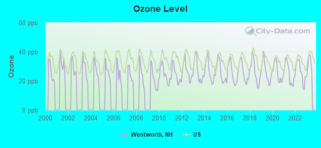
Ozone [ppb] level in 2022 was 26.1. This is better than average. Closest monitor was 10.1 miles away from the city center.
| City: | 26.1 |
| U.S.: | 33.3 |
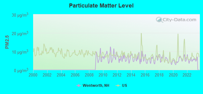
Particulate Matter (PM2.5) [µg/m3] level in 2022 was 5.54. This is significantly better than average. Closest monitor was 13.7 miles away from the city center.
| City: | 5.54 |
| U.S.: | 8.11 |
Tornado activity:
Wentworth-area historical tornado activity is below New Hampshire state average. It is 72% smaller than the overall U.S. average.
On 8/11/1966, a category F2 (max. wind speeds 113-157 mph) tornado 13.2 miles away from the Wentworth town center caused between $50,000 and $500,000 in damages.
On 5/11/1973, a category F2 tornado 20.0 miles away from the town center .
Earthquake activity:
Wentworth-area historical earthquake activity is significantly above New Hampshire state average. It is 71% smaller than the overall U.S. average.On 4/20/2002 at 10:50:47, a magnitude 5.3 (5.3 ML, Depth: 3.0 mi, Class: Moderate, Intensity: VI - VII) earthquake occurred 98.9 miles away from the city center
On 10/7/1983 at 10:18:46, a magnitude 5.3 (5.1 MB, 5.3 LG, 5.1 ML) earthquake occurred 120.7 miles away from Wentworth center
On 4/20/2002 at 10:50:47, a magnitude 5.2 (5.2 MB, 4.2 MS, 5.2 MW, 5.0 MW) earthquake occurred 99.1 miles away from the city center
On 1/19/1982 at 00:14:42, a magnitude 4.7 (4.5 MB, 4.7 MD, 4.5 LG, Class: Light, Intensity: IV - V) earthquake occurred 29.6 miles away from Wentworth center
On 10/16/2012 at 23:12:25, a magnitude 4.7 (4.7 ML, Depth: 10.0 mi) earthquake occurred 65.9 miles away from Wentworth center
On 6/16/1995 at 12:13:11, a magnitude 3.8 (3.8 LG, Depth: 3.1 mi, Class: Light, Intensity: II - III) earthquake occurred 29.6 miles away from Wentworth center
Magnitude types: regional Lg-wave magnitude (LG), body-wave magnitude (MB), duration magnitude (MD), local magnitude (ML), surface-wave magnitude (MS), moment magnitude (MW)
Natural disasters:
The number of natural disasters in Grafton County (32) is a lot greater than the US average (15).Major Disasters (Presidential) Declared: 20
Emergencies Declared: 9
Causes of natural disasters: Floods: 16, Storms: 16, Hurricanes: 3, Snows: 3, Winter Storms: 3, Tropical Storms: 2, Blizzard: 1, Heavy Rain: 1, Ice Storm: 1, Landslide: 1, Snowfall: 1, Snowstorm: 1, Wind: 1, Other: 1 (Note: some incidents may be assigned to more than one category).
Airports and heliports located in Wentworth:
See details about Airports and heliports located in Wentworth, NHColleges/universities with over 2000 students nearest to Wentworth:
- Plymouth State University (about 14 miles; Plymouth, NH; Full-time enrollment: 4,838)
- Dartmouth College (about 22 miles; Hanover, NH; FT enrollment: 6,030)
- Norwich University (about 42 miles; Northfield, VT; FT enrollment: 4,221)
- NHTI-Concord's Community College (about 49 miles; Concord, NH; FT enrollment: 2,865)
- Southern New Hampshire University (about 62 miles; Manchester, NH; FT enrollment: 16,552)
- Middlebury College (about 64 miles; Middlebury, VT; FT enrollment: 3,077)
- Saint Anselm College (about 64 miles; Manchester, NH; FT enrollment: 2,059)
Public elementary/middle school in Wentworth:
- WENTWORTH ELEMENTARY SCHOOL (Students: 57, Location: 1247 MT. MOOSILAUKE HWY., Grades: KG-8)
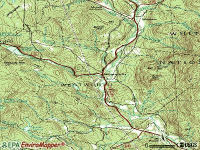
Points of interest:
Notable locations in Wentworth: Higher Ground Camp (A), Pemigewassett Camp (B), Wentworth Fire Department (C). Display/hide their locations on the map
Churches in Wentworth include: Wentworth Church (A), Wentworth Congregational Church (B). Display/hide their locations on the map
Lakes and reservoirs: Line Pond (A), Little Rocky Pond (B), Lower Baker Pond (C), Rocky Pond (D), Brackett Pond (E), Baker Floodwater Reservoir Site 6 (F), Baker Floodwater Reservoir Site (G). Display/hide their locations on the map
Streams, rivers, and creeks: Pond Brook (A), Martins Brook (B), Currier Brook (C), Clifford Brook (D), Atwell Brook (E), South Branch Baker River (F), Stevens Brook (G), Tural Brook (H). Display/hide their locations on the map
| This town: | 2.4 people |
| New Hampshire: | 2.5 people |
| This town: | 67.5% |
| Whole state: | 66.3% |
| This town: | 8.4% |
| Whole state: | 8.3% |
Likely homosexual households (counted as self-reported same-sex unmarried-partner households)
- Lesbian couples: 0.3% of all households
- Gay men: 0.3% of all households
| This town: | 7.9% |
| Whole state: | 6.5% |
| This town: | 0.9% |
| Whole state: | 2.8% |
For population 15 years and over in Wentworth:
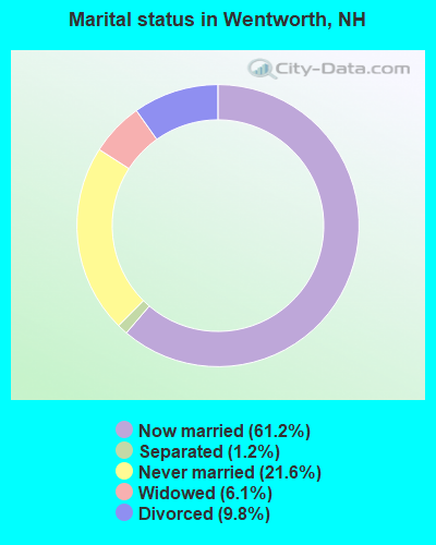
- Never married: 21.6%
- Now married: 61.2%
- Separated: 1.2%
- Widowed: 6.1%
- Divorced: 9.8%
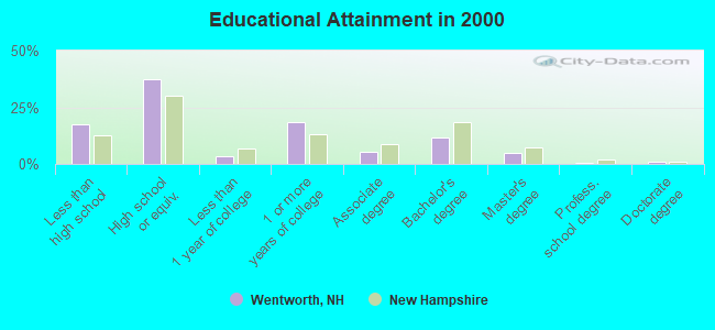
For population 25 years and over in Wentworth:
- High school or higher: 82.7%
- Bachelor's degree or higher: 17.9%
- Graduate or professional degree: 6.4%
- Unemployed: 1.1%
- Mean travel time to work (commute): 29.4 minutes
| Here: | 10.1 |
| New Hampshire average: | 10.9 |


Graphs represent county-level data. Detailed 2008 Election Results
Religion statistics for Wentworth, NH (based on Grafton County data)


| Religion | Adherents | Congregations |
|---|---|---|
| Catholic | 9,503 | 12 |
| Mainline Protestant | 7,832 | 57 |
| Evangelical Protestant | 1,494 | 29 |
| Other | 1,320 | 11 |
| None | 68,969 | - |
Food Environment Statistics:
| Grafton County: | 3.87 / 10,000 pop. |
| New Hampshire: | 2.14 / 10,000 pop. |
| Grafton County: | 0.23 / 10,000 pop. |
| State: | 0.15 / 10,000 pop. |
| Grafton County: | 1.29 / 10,000 pop. |
| State: | 1.78 / 10,000 pop. |
| This county: | 6.45 / 10,000 pop. |
| New Hampshire: | 4.02 / 10,000 pop. |
| Grafton County: | 14.41 / 10,000 pop. |
| New Hampshire: | 9.70 / 10,000 pop. |
| Grafton County: | 7.2% |
| New Hampshire: | 7.6% |
| This county: | 22.9% |
| State: | 24.4% |
| Grafton County: | 15.9% |
| State: | 15.9% |
Strongest AM radio stations in Wentworth:
- WPNH (1300 AM; 5 kW; PLYMOUTH, NH; Owner: NORTHEAST COMMUNICATIONS CORPORATION)
- WTWN (1100 AM; daytime; 5 kW; WELLS RIVER, VT; Owner: PUFFER BROADCASTING, INC.)
- WNTK (1020 AM; 10 kW; NEWPORT, NH; Owner: KOOR COMMUNICATIONS, INC.)
- WRKO (680 AM; 50 kW; BOSTON, MA; Owner: ENTERCOM BOSTON LICENSE, LLC)
- WNNZ (640 AM; 50 kW; WESTFIELD, MA; Owner: CLEAR CHANNEL BROADCASTING LICENSES, INC.)
- WCRN (830 AM; 50 kW; WORCESTER, MA; Owner: CARTER BROADCASTING CORPORATION)
- WEEI (850 AM; 50 kW; BOSTON, MA; Owner: ENTERCOM BOSTON LICENSE, LLC)
- WCHP (760 AM; 35 kW; CHAMPLAIN, NY; Owner: CHAMPLAIN RADIO, INC.)
- WEZS (1350 AM; 5 kW; LACONIA, NH; Owner: GARY W. HAMMOND)
- WGY (810 AM; 50 kW; SCHENECTADY, NY; Owner: CLEAR CHANNEL BROADCASTING LICENSES, INC.)
- WKOX (1200 AM; 50 kW; FRAMINGHAM, MA; Owner: CAPSTAR TX LIMITED PARTNERSHIP)
- WBZ (1030 AM; 50 kW; BOSTON, MA; Owner: INFINITY BROADCASTING OPERATIONS, INC.)
- WBIX (1060 AM; 40 kW; NATICK, MA; Owner: LANGER BROADCASTING CORPORATION)
Strongest FM radio stations in Wentworth:
- WPNH-FM (100.1 FM; PLYMOUTH, NH; Owner: NORTHEAST COMMUNICATIONS CORPORATION)
- WVFM (105.7 FM; CAMPTON, NH; Owner: DEVON BROADCASTING COMPANY, INC.)
- WEVH (91.3 FM; HANOVER, NH; Owner: NEW HAMPSHIRE PUBLIC RADIO INC)
- WPKQ (103.7 FM; NORTH CONWAY, NH; Owner: CITADEL BROADCASTING COMPANY)
- WHOM (94.9 FM; MT. WASHINGTON, NH; Owner: CITADEL BROADCASTING COMPANY)
- WSCY (106.9 FM; MOULTONBOROUGH, NH; Owner: NORTHEAST COMMUNICATIONS CORPORATION)
- WHDQ (106.1 FM; CLAREMONT, NH; Owner: GREAT NORTHERN RADIO, L.L.C.)
- WVPR (89.5 FM; WINDSOR, VT; Owner: VERMONT PUBLIC RADIO)
- WJJR (98.1 FM; RUTLAND, VT; Owner: 6 JOHNSON ROAD LICENSES, INC.)
- WZRT (97.1 FM; RUTLAND, VT; Owner: CAPSTAR TX LIMITED PARTNERSHIP)
- WEBK (105.3 FM; KILLINGTON, VT; Owner: 6 JOHNSON ROAD LICENSES, INC.)
- WGLV (91.7 FM; WOODSTOCK, VT; Owner: CHRISTIAN MINISTRIES INC)
- WHDQ-FM1 (106.1 FM; RUTLAND, VT; Owner: GREAT NORTHERN RADIO, L.L.C.)
- WGMT (97.7 FM; LYNDON, VT; Owner: VERMONT BROADCAST ASSOCIATES, INC.)
- WDEV-FM (96.1 FM; WARREN, VT; Owner: RADIO VERMONT, INC.)
- WCVT (101.7 FM; STOWE, VT; Owner: RADIO VERMONT CLASSICS, L.L.C.)
- WMTK (106.3 FM; LITTLETON, NH; Owner: VERMONT BROADCAST ASSOCIATES, INC.)
- WVPS (107.9 FM; BURLINGTON, VT; Owner: VERMONT PUBLIC RADIO)
- WEZF (92.9 FM; BURLINGTON, VT; Owner: CAPSTAR TX LIMITED PARTNERSHIP)
- WLKC (103.3 FM; WATERBURY, VT; Owner: RADIO BROADCASTING SERVICES, INC.)
TV broadcast stations around Wentworth:
- W15BK (Channel 15; HANOVER, NH; Owner: UNIVERSITY OF NEW HAMPSHIRE)
Wentworth fatal accident list:
Mar 23, 2009 01:35 PM, Sr-25a, Oxford Town Line, Lat: 43.901975, Lon: -72.141336, Vehicles: 1, Persons: 1, Fatalities: 1
Jun 24, 1999 03:30 PM, Atwell Hill Road, Vehicles: 2, Persons: 4, Fatalities: 1
Jan 12, 1998 09:30 AM, Sr-25, Vehicles: 1, Persons: 1, Fatalities: 1, Drunk persons involved: 1
Oct 13, 1989 11:20 PM, 63237, Vehicles: 1, Persons: 4, Fatalities: 1
- National Bridge Inventory (NBI) Statistics
- 14Number of bridges
- 118ft / 35.9mTotal length
- $43,988,000Total costs
- 10,759Total average daily traffic
- 713Total average daily truck traffic
- 15,913Total future (year 2042) average daily traffic
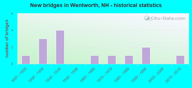
- New bridges - historical statistics
- 11920-1929
- 31930-1939
- 41940-1949
- 11960-1969
- 11970-1979
- 11980-1989
- 21990-1999
- 12010-2019
FCC Registered Antenna Towers:
3- Michael J Umano, Off Ellsworth Hill Road (Lat: 43.865750 Lon: -71.929139), Type: 61.0, Structure height: 33009 m, Overall height: 59.4 m, Registrant: Industrial Tower And Wireless, LLC, Kevin.Delaney@induscom.Com, , Marsh-field, Phone: (781) 319-1011
- Michael J Umano, Off Ellsworth Hill Road (Lat: 43.865750 Lon: -71.929139), Type: 61.0, Structure height: 33009 m, Overall height: 59.4 m, Registrant: Industrial Tower And Wireless, LLC, Kevin.Delaney@induscom.Com, , Marsh-field, Phone: (781) 319-1011
- Michael J Umano, Off Ellsworth Hill Road (Lat: 43.865750 Lon: -71.929139), Type: 61.0, Structure height: 33009 m, Overall height: 59.4 m, Registrant: Industrial Tower And Wireless, LLC, Kevin.Delaney@induscom.Com, , Marsh-field, Phone: (781) 319-1011
FCC Registered Amateur Radio Licenses:
5- Call Sign: N1UJI, Licensee ID: L00795784, Grant Date: 01/07/2015, Expiration Date: 02/17/2025, Certifier: Brian A Du Bois, Registrant: Brian A Du Bois, 469 Atwell Hill Road, Wentworth, NH 03282
- Call Sign: KB1EOU, Licensee ID: L00172230, Grant Date: 08/21/2009, Expiration Date: 11/16/2019, Cancellation Date: 11/17/2021, Certifier: Beverly F Walker, Registrant: Beverly F Walker, 578 N Dorchester Rd, Wentworth, NH 03282
- Call Sign: W1QR, Previous Call Sign: N1AYR, Licensee ID: L00325125, Grant Date: 01/27/2012, Expiration Date: 03/20/2022, Cancellation Date: 03/21/2024, Certifier: Richard N Cadieux, Registrant: Richard N Cadieux, 33 Dancing Bones Rd, Wentworth, NH 03282
- Call Sign: W2EDM, Previous Call Sign: KC2ODO, Licensee ID: L00977337, Grant Date: 06/25/2016, Expiration Date: 06/25/2026, Certifier: Edward Morandi, Registrant: Edward Morandi, Wentworth, NH 03282
- Call Sign: KF5PQN, Licensee ID: L01705732, Grant Date: 04/25/2012, Expiration Date: 04/25/2022, Certifier: Andrew P Lasser, Registrant: Andrew P Lasser, Wentworth, NH 03282
FAA Registered Aircraft:
3- Aircraft: CESSNA 180 (Category: Land, Seats: 4, Weight: Up to 12,499 Pounds, Speed: 121 mph), Engine: CONT MOTOR O-470 SERIES (230 HP) (Reciprocating)
N-Number: 180SM, N180SM, N-180SM, Serial Number: 30442, Year manufactured: 1953, Airworthiness Date: 09/05/1956, Certificate Issue Date: 07/26/2013
Registrant (Individual): John P Meade, Po Box 5, Wentworth, NH 03282 - Aircraft: CESSNA 182Q (Category: Land, Seats: 4, Weight: Up to 12,499 Pounds, Speed: 112 mph), Engine: CONT MOTOR O-470 SERIES (230 HP) (Reciprocating)
N-Number: 759UJ, N759UJ, N-759UJ, Serial Number: 18266267, Year manufactured: 1978, Airworthiness Date: 03/01/1978, Certificate Issue Date: 06/18/2019
Registrant (Corporation): King Forest Ind Inc, Po Box 230, Wentworth, NH 03282 - Aircraft: PIPER PA-18A (Category: Land, Seats: 2, Weight: Up to 12,499 Pounds, Speed: 97 mph), Engine: LYCOMING 0-320 SERIES (180 HP) (Reciprocating)
N-Number: 956MD, N956MD, N-956MD, Serial Number: 18-4884, Year manufactured: 1956, Airworthiness Date: 05/20/1970, Certificate Issue Date: 08/23/2004
Registrant (Individual): John P Meade, Po Box 5, Wentworth, NH 03282
2003 - 2018 National Fire Incident Reporting System (NFIRS) incidents
- Fire incident types reported to NFIRS in Wentworth, NH
- 8581.7%Structure Fires
- 1110.6%Outside Fires
- 54.8%Mobile Property/Vehicle Fires
- 32.9%Other
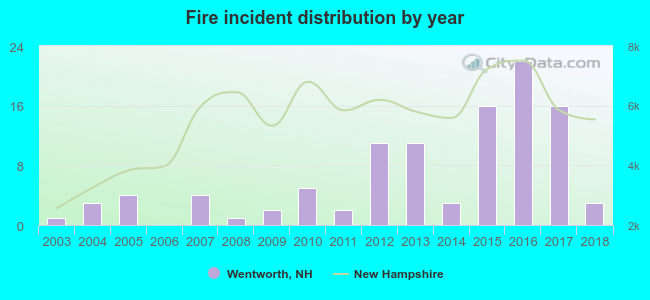 According to the data from the years 2003 - 2018 the average number of fires per year is 6. The highest number of reported fires - 22 took place in 2016, and the least - 0 in 2006. The data has an increasing trend.
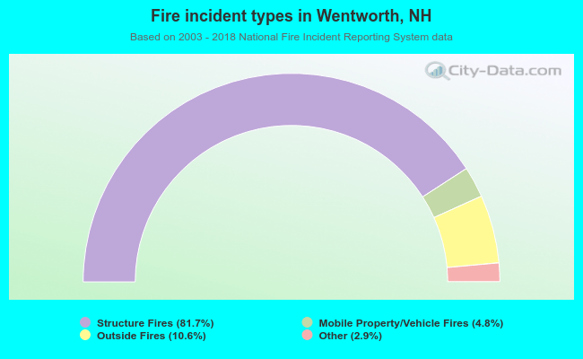 When looking into fire subcategories, the most reports belonged to: Structure Fires (81.7%), and Outside Fires (10.6%).
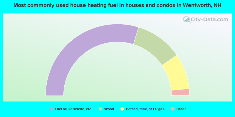
- 59.5%Fuel oil, kerosene, etc.
- 21.4%Wood
- 16.0%Bottled, tank, or LP gas
- 2.3%Electricity
- 0.8%Utility gas
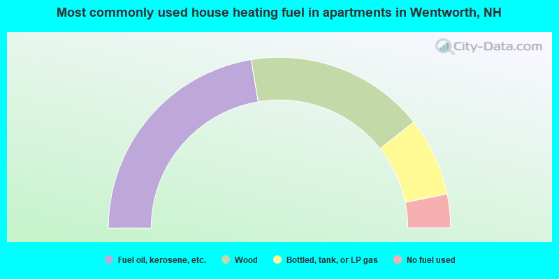
- 44.7%Fuel oil, kerosene, etc.
- 34.0%Wood
- 14.9%Bottled, tank, or LP gas
- 6.4%No fuel used
Wentworth compared to New Hampshire state average:
- Unemployed percentage significantly below state average.
- Black race population percentage significantly below state average.
- Hispanic race population percentage significantly below state average.
- Foreign-born population percentage significantly below state average.
- Renting percentage below state average.
- Length of stay since moving in significantly above state average.
- Number of rooms per house significantly below state average.
- House age significantly below state average.
- Percentage of population with a bachelor's degree or higher below state average.