West Greenwich, Rhode Island
Submit your own pictures of this town and show them to the world
- OSM Map
- Google Map
- MSN Map
Population change since 2000: +20.6%
| Males: 3,054 | |
| Females: 3,081 |
| Median resident age: | 41.3 years |
| Rhode Island median age: | 42.3 years |
Zip codes: 02817.
| West Greenwich: | $117,869 |
| RI: | $81,854 |
Estimated per capita income in 2022: $49,067 (it was $25,750 in 2000)
West Greenwich town income, earnings, and wages data
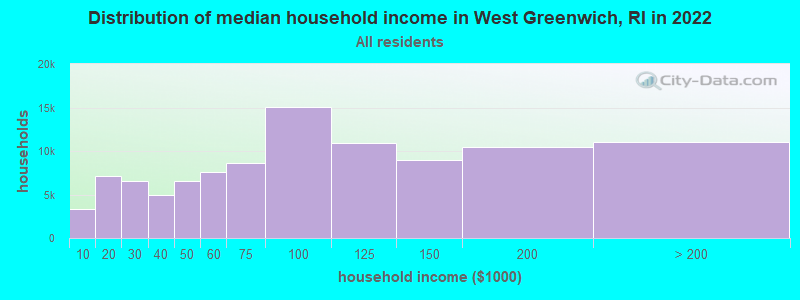
Estimated median house or condo value in 2022: $484,124 (it was $166,900 in 2000)
| West Greenwich: | $484,124 |
| RI: | $383,900 |
Mean prices in 2022: all housing units: $378,490; detached houses: $398,338; townhouses or other attached units: $357,193; in 2-unit structures: $303,020; in 3-to-4-unit structures: $233,611; in 5-or-more-unit structures: $254,381; mobile homes: $77,021
West Greenwich, RI residents, houses, and apartments details
Detailed information about poverty and poor residents in West Greenwich, RI


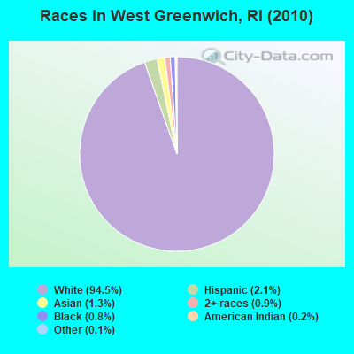
- 5,79694.5%White alone
- 1312.1%Hispanic
- 811.3%Asian alone
- 570.9%Two or more races
- 480.8%Black alone
- 150.2%American Indian alone
- 70.1%Other race alone
Races in West Greenwich detailed stats: ancestries, foreign born residents, place of birth
According to our research of Rhode Island and other state lists, there were 7 registered sex offenders living in West Greenwich, Rhode Island as of April 29, 2024.
The ratio of all residents to sex offenders in West Greenwich is 876 to 1.
The ratio of registered sex offenders to all residents in this city is near the state average.
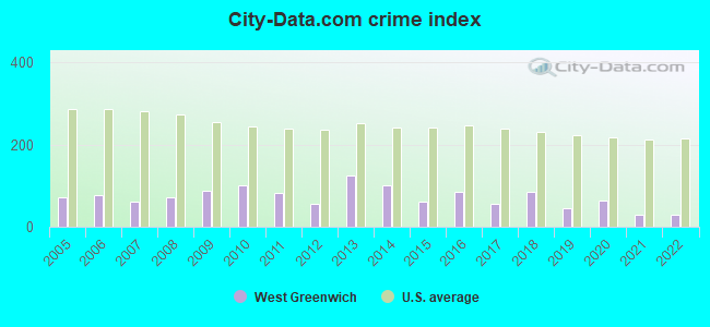
Type |
2009 |
2010 |
2011 |
2012 |
2013 |
2014 |
2015 |
2016 |
2017 |
2018 |
2019 |
2020 |
2021 |
2022 |
|---|---|---|---|---|---|---|---|---|---|---|---|---|---|---|
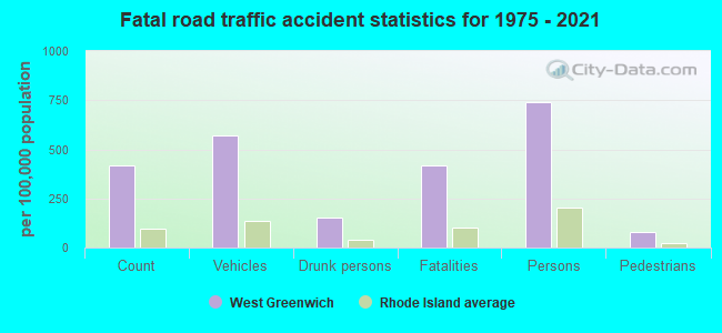
| Murders (per 100,000) | 0 (0.0) | 0 (0.0) | 0 (0.0) | 0 (0.0) | 0 (0.0) | 0 (0.0) | 0 (0.0) | 1 (16.3) | 0 (0.0) | 0 (0.0) | 0 (0.0) | 0 (0.0) | 0 (0.0) | 0 (0.0) |
| Rapes (per 100,000) | 0 (0.0) | 0 (0.0) | 0 (0.0) | 1 (16.4) | 3 (49.3) | 2 (32.7) | 0 (0.0) | 1 (16.3) | 0 (0.0) | 3 (48.2) | 0 (0.0) | 2 (31.3) | 0 (0.0) | 0 (0.0) |
| Robberies (per 100,000) | 1 (15.3) | 1 (16.3) | 1 (16.3) | 1 (16.4) | 1 (16.4) | 2 (32.7) | 0 (0.0) | 0 (0.0) | 0 (0.0) | 0 (0.0) | 1 (15.7) | 0 (0.0) | 0 (0.0) | 0 (0.0) |
| Assaults (per 100,000) | 2 (30.6) | 1 (16.3) | 3 (49.0) | 0 (0.0) | 3 (49.3) | 4 (65.3) | 3 (49.0) | 3 (48.9) | 2 (32.4) | 2 (32.1) | 3 (47.1) | 2 (31.3) | 2 (29.9) | 2 (29.7) |
| Burglaries (per 100,000) | 24 (367.0) | 32 (521.6) | 15 (244.8) | 10 (163.8) | 28 (460.1) | 12 (196.0) | 11 (179.8) | 5 (81.5) | 16 (259.4) | 12 (192.7) | 10 (156.9) | 6 (93.8) | 1 (15.0) | 3 (44.6) |
| Thefts (per 100,000) | 80 (1,223) | 79 (1,288) | 55 (897.5) | 37 (606.0) | 50 (821.7) | 55 (898.4) | 51 (833.7) | 31 (505.5) | 46 (745.9) | 25 (401.5) | 24 (376.5) | 30 (468.8) | 27 (404.2) | 28 (416.2) |
| Auto thefts (per 100,000) | 2 (30.6) | 4 (65.2) | 11 (179.5) | 1 (16.4) | 4 (65.7) | 1 (16.3) | 3 (49.0) | 3 (48.9) | 2 (32.4) | 8 (128.5) | 3 (47.1) | 7 (109.4) | 5 (74.9) | 3 (44.6) |
| Arson (per 100,000) | 3 (45.9) | 0 (0.0) | 2 (32.6) | 2 (32.8) | 2 (32.9) | 0 (0.0) | 0 (0.0) | 1 (16.3) | 1 (16.2) | 0 (0.0) | 0 (0.0) | 0 (0.0) | 0 (0.0) | 0 (0.0) |
| City-Data.com crime index | 87.8 | 101.4 | 82.1 | 55.0 | 124.6 | 100.0 | 59.7 | 85.3 | 57.1 | 84.8 | 43.9 | 65.3 | 29.2 | 29.3 |
The City-Data.com crime index weighs serious crimes and violent crimes more heavily. Higher means more crime, U.S. average is 246.1. It adjusts for the number of visitors and daily workers commuting into cities.
Crime rate in West Greenwich detailed stats: murders, rapes, robberies, assaults, burglaries, thefts, arson
Full-time law enforcement employees in 2021, including police officers: 19 (13 officers - 13 male; 0 female).
| Officers per 1,000 residents here: | 1.95 |
| Rhode Island average: | 2.27 |
 Recent articles from our blog. Our writers, many of them Ph.D. graduates or candidates, create easy-to-read articles on a wide variety of topics.
Ancestries: Irish (26.3%), English (22.2%), Italian (18.7%), French (16.6%), French Canadian (10.4%), German (8.1%).
Current Local Time: EST time zone
Incorporated in 1741
Land area: 50.6 square miles.
Population density: 121 people per square mile (very low).
131 residents are foreign born (0.8% Europe, 0.7% North America, 0.5% Asia, 0.5% Latin America).
| This town: | 2.6% |
| Rhode Island: | 11.4% |
| West Greenwich town: | 1.6% ($2,712) |
| Rhode Island: | 1.9% ($2,507) |
Nearest city with pop. 50,000+: Warwick, RI  (14.1 miles , pop. 85,808).
Nearest city with pop. 200,000+: Boston, MA (56.2 miles , pop. 589,141).
Nearest city with pop. 1,000,000+: Bronx, NY (127.2 miles , pop. 1,332,650).
Nearest cities:
), ), Latitude: 41.63 N, Longitude: 71.66 W
Area code commonly used in this area: 401
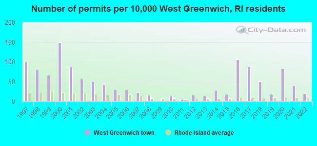
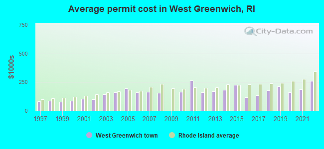
Single-family new house construction building permits:
- 2022: 10 buildings, average cost: $262,200
- 2021: 21 buildings, average cost: $185,500
- 2020: 42 buildings, average cost: $163,000
- 2019: 9 buildings, average cost: $212,400
- 2018: 26 buildings, average cost: $179,800
- 2017: 45 buildings, average cost: $134,900
- 2016: 54 buildings, average cost: $115,600
- 2015: 9 buildings, average cost: $223,600
- 2014: 15 buildings, average cost: $180,700
- 2013: 7 buildings, average cost: $167,800
- 2012: 8 buildings, average cost: $163,100
- 2011: 2 buildings, average cost: $265,000
- 2010: 7 buildings, average cost: $164,300
- 2008: 8 buildings, average cost: $155,300
- 2007: 11 buildings, average cost: $165,200
- 2006: 16 buildings, average cost: $160,200
- 2005: 16 buildings, average cost: $193,900
- 2004: 22 buildings, average cost: $159,900
- 2003: 25 buildings, average cost: $144,200
- 2002: 29 buildings, average cost: $99,600
- 2001: 45 buildings, average cost: $104,200
- 2000: 76 buildings, average cost: $86,400
- 1999: 34 buildings, average cost: $79,900
- 1998: 41 buildings, average cost: $84,700
- 1997: 51 buildings, average cost: $82,900
| Here: | 2.7% |
| Rhode Island: | 3.3% |
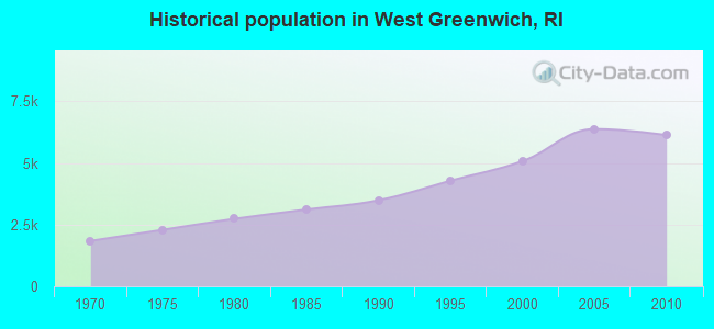
Population change in the 1990s: +1,889 (+59.1%).
- Educational services (12.1%)
- Health care (10.0%)
- Accommodation & food services (7.0%)
- Construction (6.8%)
- Public administration (5.3%)
- Finance & insurance (5.2%)
- Professional, scientific, technical services (4.0%)
- Construction (11.1%)
- Public administration (7.6%)
- Accommodation & food services (6.5%)
- Educational services (6.1%)
- Miscellaneous manufacturing (5.3%)
- Metal & metal products (5.1%)
- Professional, scientific, technical services (4.1%)
- Health care (19.5%)
- Educational services (18.9%)
- Accommodation & food services (7.6%)
- Finance & insurance (7.0%)
- Professional, scientific, technical services (3.8%)
- Computer & electronic products (3.5%)
- Social assistance (2.9%)
- Other office and administrative support workers, including supervisors (5.0%)
- Other management occupations, except farmers and farm managers (4.8%)
- Material recording, scheduling, dispatching, and distributing workers (4.5%)
- Registered nurses (4.4%)
- Secretaries and administrative assistants (4.3%)
- Other production occupations, including supervisors (4.0%)
- Other sales and related occupations, including supervisors (3.9%)
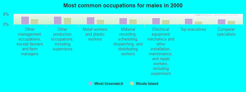
- Other management occupations, except farmers and farm managers (6.4%)
- Other production occupations, including supervisors (6.3%)
- Metal workers and plastic workers (5.7%)
- Material recording, scheduling, dispatching, and distributing workers (5.1%)
- Electrical equipment mechanics and other installation, maintenance, and repair workers, including supervisors (5.0%)
- Top executives (4.7%)
- Computer specialists (4.2%)
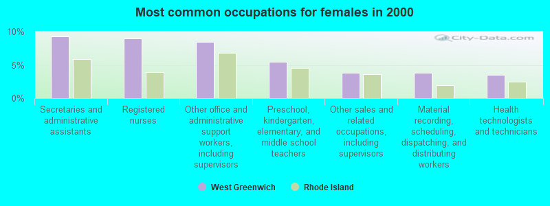
- Secretaries and administrative assistants (9.3%)
- Registered nurses (9.0%)
- Other office and administrative support workers, including supervisors (8.5%)
- Preschool, kindergarten, elementary, and middle school teachers (5.5%)
- Other sales and related occupations, including supervisors (3.9%)
- Material recording, scheduling, dispatching, and distributing workers (3.8%)
- Health technologists and technicians (3.5%)
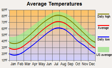
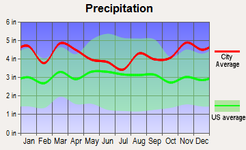
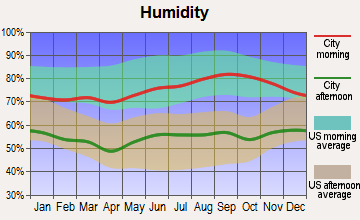
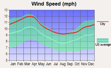
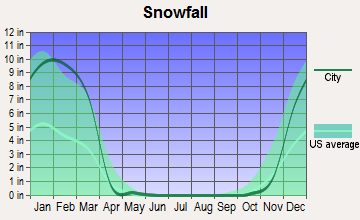
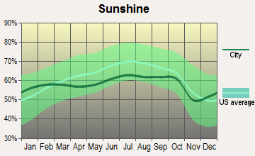
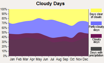
Average climate in West Greenwich, Rhode Island
Based on data reported by over 4,000 weather stations
(lower is better)
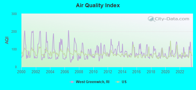
Air Quality Index (AQI) level in 2023 was 88.8. This is worse than average.
| City: | 88.8 |
| U.S.: | 72.6 |
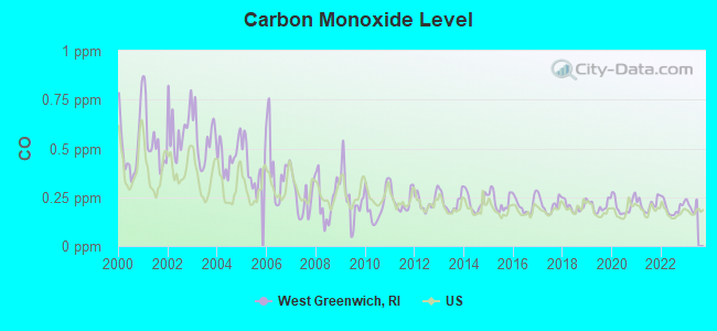
Carbon Monoxide (CO) [ppm] level in 2022 was 0.196. This is better than average. Closest monitor was 18.4 miles away from the city center.
| City: | 0.196 |
| U.S.: | 0.251 |
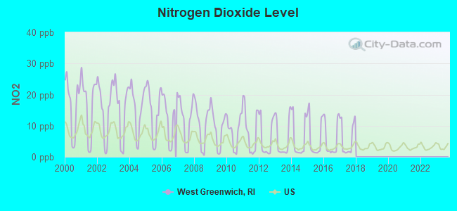
Nitrogen Dioxide (NO2) [ppb] level in 2017 was 5.73. This is about average. Closest monitor was 3.2 miles away from the city center.
| City: | 5.73 |
| U.S.: | 5.11 |
Sulfur Dioxide (SO2) [ppb] level in 2022 was 0.179. This is significantly better than average. Closest monitor was 1.5 miles away from the city center.
| City: | 0.179 |
| U.S.: | 1.515 |
Ozone [ppb] level in 2023 was 33.1. This is about average. Closest monitor was 3.2 miles away from the city center.
| City: | 33.1 |
| U.S.: | 33.3 |
Particulate Matter (PM2.5) [µg/m3] level in 2022 was 3.99. This is significantly better than average. Closest monitor was 3.2 miles away from the city center.
| City: | 3.99 |
| U.S.: | 8.11 |
Lead (Pb) [µg/m3] level in 2001 was 0.0163. This is significantly worse than average. Closest monitor was 3.2 miles away from the city center.
| City: | 0.0163 |
| U.S.: | 0.0093 |
Tornado activity:
West Greenwich-area historical tornado activity is near Rhode Island state average. It is 50% smaller than the overall U.S. average.
On 6/9/1953, a category F4 (max. wind speeds 207-260 mph) tornado 46.9 miles away from the West Greenwich town center killed 90 people and injured 1228 people and caused between $50,000,000 and $500,000,000 in damages.
On 6/9/1953, a category F3 (max. wind speeds 158-206 mph) tornado 37.5 miles away from the town center injured 17 people and caused between $500,000 and $5,000,000 in damages.
Earthquake activity:
West Greenwich-area historical earthquake activity is significantly above Rhode Island state average. It is 73% smaller than the overall U.S. average.On 10/7/1983 at 10:18:46, a magnitude 5.3 (5.1 MB, 5.3 LG, 5.1 ML, Class: Moderate, Intensity: VI - VII) earthquake occurred 210.6 miles away from West Greenwich center
On 4/20/2002 at 10:50:47, a magnitude 5.3 (5.3 ML, Depth: 3.0 mi) earthquake occurred 224.4 miles away from West Greenwich center
On 4/20/2002 at 10:50:47, a magnitude 5.2 (5.2 MB, 4.2 MS, 5.2 MW, 5.0 MW) earthquake occurred 223.3 miles away from the city center
On 1/19/1982 at 00:14:42, a magnitude 4.7 (4.5 MB, 4.7 MD, 4.5 LG, Class: Light, Intensity: IV - V) earthquake occurred 129.4 miles away from the city center
On 10/16/2012 at 23:12:25, a magnitude 4.7 (4.7 ML, Depth: 10.0 mi) earthquake occurred 145.4 miles away from West Greenwich center
On 8/22/1992 at 12:20:32, a magnitude 4.8 (4.8 MB, 3.8 MS, 4.7 LG, Depth: 6.2 mi) earthquake occurred 188.3 miles away from the city center
Magnitude types: regional Lg-wave magnitude (LG), body-wave magnitude (MB), duration magnitude (MD), local magnitude (ML), surface-wave magnitude (MS), moment magnitude (MW)
Natural disasters:
The number of natural disasters in Kent County (17) is near the US average (15).Major Disasters (Presidential) Declared: 8
Emergencies Declared: 8
Causes of natural disasters: Hurricanes: 6, Blizzards: 3, Snowstorms: 3, Floods: 2, Storms: 2, Winter Storms: 2, Snow: 1, Snowfall: 1, Tropical Storm: 1, Water Main Break: 1, Wind: 1, Other: 1 (Note: some incidents may be assigned to more than one category).
Main business address for: GTECH HOLDINGS CORP (SERVICES-COMPUTER PROGRAMMING, DATA PROCESSING, ETC.).
Hospitals and medical centers near West Greenwich:
- ALPINE NURSING HOME INC (Nursing Home, about 3 miles away; COVENTRY, RI)
- COVENTRY HEALTH CENTER (Nursing Home, about 5 miles away; COVENTRY, RI)
- COVENTRY SKILLED NURSING AND REHABILITATION (Nursing Home, about 5 miles away; COVENTRY, RI)
- LAUREL FOSTER HOME (Nursing Home, about 8 miles away; COVENTRY, RI)
- WOODPECKER HILL HEALTH CENTER (Nursing Home, about 8 miles away; GREENE, RI)
- DEPENDABLE HOMECARE SERVICES (Home Health Center, about 9 miles away; WYOMING, RI)
- WEST VIEW HEALTH CARE CENTER (Nursing Home, about 10 miles away; WEST WARWICK, RI)
Amtrak stations near West Greenwich:
- 12 miles: KINGSTON (WEST KINGSTON, FAIRGROUNDS RD.) . Services: ticket office, enclosed waiting area, public restrooms, public payphones, free short-term parking, free long-term parking, call for car rental service, call for taxi service, public transit connection.
- 19 miles: PROVIDENCE (100 GASPEE ST.) . Services: ticket office, fully wheelchair accessible, enclosed waiting area, public restrooms, public payphones, snack bar, ATM, paid short-term parking, paid long-term parking, call for car rental service, taxi stand, public transit connection.
- 20 miles: WESTERLY (14 RAILROAD AVE.) . Services: ticket office, enclosed waiting area, public restrooms, public payphones, vending machines, paid short-term parking, call for car rental service, call for taxi service, public transit connection.
Colleges/universities with over 2000 students nearest to West Greenwich:
- New England Institute of Technology (about 9 miles; East Greenwich, RI; Full-time enrollment: 3,183)
- Community College of Rhode Island (about 11 miles; Warwick, RI; FT enrollment: 10,500)
- University of Rhode Island (about 13 miles; Kingston, RI; FT enrollment: 14,656)
- Rhode Island College (about 18 miles; Providence, RI; FT enrollment: 7,189)
- Johnson & Wales University-Providence (about 19 miles; Providence, RI; FT enrollment: 10,898)
- Providence College (about 19 miles; Providence, RI; FT enrollment: 4,312)
- Rhode Island School of Design (about 19 miles; Providence, RI; FT enrollment: 2,714)
Public high schools in West Greenwich:
- EXETER-WEST GREENWICH REGIONAL (Students: 335, Location: 930 NOOSENECK HILL ROAD, Grades: 9-12)
- THE GREENE SCHOOL (Location: 94 JOHN POTTER ROAD, Grades: 9-12, Charter school)
Public elementary/middle school in West Greenwich:
- EXETER-WEST GREENWICH REG. JR. (Students: 671, Location: 930 NOOSENECK HILL ROAD, Grades: 7-8)
Points of interest:
Notable locations in West Greenwich: Camp E-Hun-Tee (A), Camp Bosco (B), West Greenwich Center (C), Louttit Library (D), West Greenwich Rescue 2 (E), Hianloland Fire Department Station 1 (F), West Greenwich Town Hall (G), West Greenwich Police Department (H), West Greenwich Fire Department (I), Wee Care Day Care Center (J), Primary Colors Childrens Centre of New England (K), Lake Mishnock Volunteer Fire Department (L), Hianloland Fire Company Station 2 Rescue 3 (M), GTECH Child Care Center (N), Childrens Centre of New England (O). Display/hide their locations on the map
Main business address in West Greenwich: GTECH HOLDINGS CORP (A). Display/hide its location on the map
Churches in West Greenwich include: West Greenwich Baptist Church (A), Sharp Street Church (B). Display/hide their locations on the map
Cemetery: West Greenwich Cemetery (1). Display/hide its location on the map
Lakes, reservoirs, and swamps: Eisenhower Lake (A), Wickaboxet Pond (B), Tillinghast Pond (C), Fry Pond (D), Yard Pond (E), Phelps Pond (F), Lake Mishnock (G), Tippecansett Pond (H). Display/hide their locations on the map
Streams, rivers, and creeks: Kelley Brook (A), Congdon River (B), Nooseneck River (C), Phillips Brook (D), Carr River (E), Mud Bottom Brook (F), Coney Brook (G), Raccoon Brook (H), Factory Brook (I). Display/hide their locations on the map
Park in West Greenwich: Big River State Management Area (1). Display/hide its location on the map
Birthplace of: Charles Tillinghast James - Politician.
Drinking water stations with addresses in West Greenwich and their reported violations in the past:
EXETER-W.GREENWICH JR/SR HIGH SCHOOL (Population served: 1,050, Groundwater):Past health violations:METCALF ELEMENTARY SCHOOL (Population served: 762, Groundwater):Past monitoring violations:
- MCL, Monthly (TCR) - In NOV-2010, Contaminant: Coliform. Follow-up actions: St Violation/Reminder Notice (NOV-10-2010), St Boil Water Order (NOV-10-2010), St Formal NOV issued (NOV-10-2010), St Public Notif requested (NOV-10-2010), St Public Notif received (NOV-18-2010), St Compliance achieved (DEC-02-2010)
- MCL, Monthly (TCR) - In SEP-2010, Contaminant: Coliform. Follow-up actions: St Violation/Reminder Notice (SEP-07-2010), St Boil Water Order (SEP-07-2010), St Formal NOV issued (SEP-07-2010), St Public Notif requested (SEP-07-2010), St Public Notif received (SEP-13-2010), St Compliance achieved (NOV-08-2010)
- MCL, Monthly (TCR) - In OCT-2009, Contaminant: Coliform. Follow-up actions: St Public Notif requested (OCT-15-2009), St Formal NOV issued (OCT-15-2009), St Boil Water Order (OCT-15-2009), St Violation/Reminder Notice (OCT-15-2009), St Public Notif received (OCT-23-2009), St Compliance achieved (OCT-23-2009)
- MCL, Monthly (TCR) - In SEP-2009, Contaminant: Coliform. Follow-up actions: St Violation/Reminder Notice (SEP-04-2009), St Boil Water Order (SEP-04-2009), St Formal NOV issued (SEP-04-2009), St Public Notif requested (SEP-04-2009), St Compliance achieved (SEP-16-2009), St Public Notif received (SEP-16-2009)
- Monitoring, Source Water (GWR) - In SEP-01-2010, Contaminant: E. COLI. Follow-up actions: St Public Notif requested (SEP-30-2010), St Formal NOV issued (SEP-30-2010), St Violation/Reminder Notice (SEP-30-2010), St Public Notif received (OCT-07-2010), St Compliance achieved (OCT-26-2010)
Past health violations:WAWALOAM SCHOOL (Population served: 355, Groundwater):
- MCL, Monthly (TCR) - In AUG-2011, Contaminant: Coliform. Follow-up actions: St Violation/Reminder Notice (AUG-30-2011), St Boil Water Order (AUG-30-2011), St Formal NOV issued (AUG-30-2011), St Public Notif requested (AUG-30-2011), St Compliance achieved (SEP-19-2011), St Public Notif received (SEP-19-2011)
- MCL, Monthly (TCR) - In JUL-2010, Contaminant: Coliform. Follow-up actions: St Formal NOV issued (JUL-16-2010), St Violation/Reminder Notice (JUL-16-2010), St Public Notif requested (JUL-16-2010), St Public Notif received (JUL-22-2010), St Compliance achieved (AUG-12-2010)
- MCL, Monthly (TCR) - In OCT-2009, Contaminant: Coliform. Follow-up actions: St Boil Water Order (OCT-21-2009), St Public Notif requested (OCT-21-2009), St Violation/Reminder Notice (OCT-21-2009), St Formal NOV issued (OCT-21-2009), St Public Notif received (OCT-30-2009), St Compliance achieved (OCT-30-2009)
Past health violations:W. ALTON JONES CAMPUS - ENVIRONMENTAL ED (Population served: 100, Groundwater):
- MCL, Monthly (TCR) - Between JAN-2007 and MAR-2007, Contaminant: Coliform. Follow-up actions: St Violation/Reminder Notice (JAN-18-2007), St Boil Water Order (JAN-18-2007), St Formal NOV issued (JAN-18-2007), St Public Notif requested (JAN-18-2007), St Compliance achieved (MAR-13-2007), St Public Notif received (MAR-13-2007)
Past health violations:W. ALTON JONES CAMPUS - URI POOR FARM (Population served: 100, Groundwater):Past monitoring violations:
- MCL, Monthly (TCR) - Between APR-2011 and JUN-2011, Contaminant: Coliform. Follow-up actions: St Violation/Reminder Notice (JUL-05-2011), St Boil Water Order (JUL-05-2011), St Formal NOV issued (JUL-05-2011), St Public Notif requested (JUL-05-2011), St Compliance achieved (JUL-25-2011), St Public Notif received (JUL-25-2011)
- 3 routine major monitoring violations
Past health violations:WEST GREENWICH CONDO ASSOC. (Population served: 100, Groundwater):Past monitoring violations:
- MCL, Monthly (TCR) - In SEP-2011, Contaminant: Coliform. Follow-up actions: St Formal NOV issued (SEP-23-2011), St Violation/Reminder Notice (SEP-23-2011), St Public Notif requested (SEP-23-2011), St Public Notif received (OCT-07-2011), St BCA signed (OCT-11-2011), St Compliance achieved (2 times from OCT-11-2011 to FEB-15-2012)
- MCL, Monthly (TCR) - In JUL-2011, Contaminant: Coliform. Follow-up actions: St Formal NOV issued (JUL-14-2011), St Violation/Reminder Notice (JUL-14-2011), St Public Notif requested (JUL-14-2011), St Public Notif received (AUG-05-2011), St Compliance achieved (AUG-05-2011), St BCA signed (OCT-11-2011)
- MCL, Monthly (TCR) - Between APR-2011 and JUN-2011, Contaminant: Coliform. Follow-up actions: St Formal NOV issued (JUL-05-2011), St Violation/Reminder Notice (JUL-05-2011), St Public Notif requested (JUL-05-2011), St Public Notif received (JUL-25-2011), St Compliance achieved (AUG-03-2011), St BCA signed (OCT-11-2011)
- MCL, Monthly (TCR) - In AUG-2006, Contaminant: Coliform. Follow-up actions: St Public Notif requested (AUG-21-2006), St Formal NOV issued (AUG-21-2006), St Violation/Reminder Notice (AUG-21-2006), St Public Notif received (AUG-10-2007), St Compliance achieved (AUG-10-2007)
- MCL, Monthly (TCR) - Between JUL-2006 and SEP-2006, Contaminant: Coliform. Follow-up actions: St Violation/Reminder Notice (AUG-02-2006), St Formal NOV issued (AUG-02-2006), St Public Notif requested (AUG-02-2006), St Public Notif received (AUG-10-2007), St Compliance achieved (AUG-10-2007)
- 6 routine major monitoring violations
Past health violations:DANS PLACE (Population served: 75, Groundwater):Past monitoring violations:
- MCL, Monthly (TCR) - Between OCT-2007 and DEC-2007, Contaminant: Coliform. Follow-up actions: St Violation/Reminder Notice (OCT-29-2007), St Boil Water Order (OCT-29-2007), St Formal NOV issued (OCT-29-2007), St Public Notif requested (OCT-29-2007), St Compliance achieved (NOV-07-2007), St Public Notif received (NOV-07-2007)
- One routine major monitoring violation
Past monitoring violations:OAK EMBERS CAMPGROUND (Population served: 69, Groundwater):
- One routine major monitoring violation
Past health violations:Past monitoring violations:
- MCL, Average - Between APR-2013 and JUN-2013, Contaminant: Nitrate. Follow-up actions: St Boil Water Order (JUN-06-2013), St Public Notif requested (JUN-06-2013), St Violation/Reminder Notice (JUN-06-2013), St Formal NOV issued (JUN-06-2013), St Public Notif received (JUL-15-2013), St Compliance achieved (AUG-28-2013)
- MCL, Average - Between JAN-2013 and MAR-2013, Contaminant: Nitrate. Follow-up actions: St Formal NOV issued (FEB-01-2013), St Public Notif requested (FEB-01-2013), St Violation/Reminder Notice (FEB-01-2013), St Public Notif received (JUL-15-2013), St Compliance achieved (AUG-28-2013)
- MCL, Monthly (TCR) - Between APR-2012 and JUN-2012, Contaminant: Coliform. Follow-up actions: St Public Notif requested (JUN-28-2012), St Formal NOV issued (JUN-28-2012), St Violation/Reminder Notice (JUN-28-2012), St Public Notif received (JUL-23-2012), St Compliance achieved (AUG-22-2012)
- MCL, Monthly (TCR) - Between APR-2011 and JUN-2011, Contaminant: Coliform. Follow-up actions: St Formal NOV issued (JUL-01-2011), St Violation/Reminder Notice (JUL-01-2011), St Public Notif requested (JUL-01-2011), St Public Notif received (JUL-14-2011), St Compliance achieved (JUL-28-2011)
- MCL, Monthly (TCR) - Between APR-2009 and JUN-2009, Contaminant: Coliform. Follow-up actions: St Formal NOV issued (JUN-08-2009), St Violation/Reminder Notice (JUN-08-2009), St Public Notif requested (JUN-08-2009), St Compliance achieved (JUL-29-2009), St Public Notif received (JUL-29-2009)
- One routine major monitoring violation
Drinking water stations with addresses in West Greenwich that have no violations reported:
- MILDRED E LINEHAM SCHOOL (Population served: 160, Primary Water Source Type: Groundwater)
- BLUEBERRY HEIGHTS HOUSING COOPERATIVE CO (Population served: 44, Primary Water Source Type: Groundwater)
- ROCHS FRESH FOODS FACILITY (Population served: 25, Primary Water Source Type: Groundwater)
| This town: | 2.8 people |
| Rhode Island: | 2.4 people |
| This town: | 78.4% |
| Whole state: | 62.8% |
| This town: | 4.7% |
| Whole state: | 7.6% |
Likely homosexual households (counted as self-reported same-sex unmarried-partner households)
- Lesbian couples: 0.5% of all households
- Gay men: 0.4% of all households
| This town: | 4.2% |
| Whole state: | 11.9% |
| This town: | 1.0% |
| Whole state: | 5.4% |
People in group quarters in West Greenwich in 2010:
- 12 people in workers' group living quarters and job corps centers
- 9 people in residential treatment centers for juveniles (non-correctional)
- 4 people in group homes intended for adults
Banks with branches in West Greenwich (2011 data):
- Centreville Savings Bank: West Greenwich Branch at 834 Victory Highway, branch established on 1991/10/03. Info updated 2006/11/03: Bank assets: $965.6 mil, Deposits: $725.3 mil, headquarters in West Warwick, RI, positive income, 6 total offices
For population 15 years and over in West Greenwich:
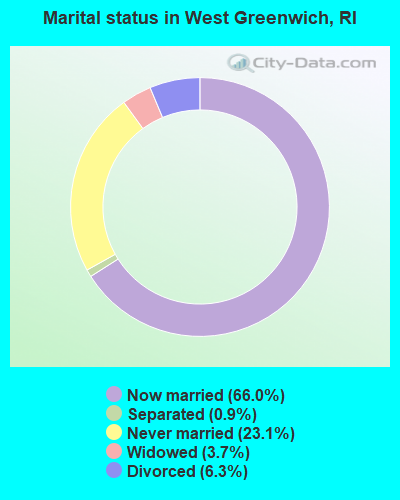
- Never married: 23.1%
- Now married: 66.0%
- Separated: 0.9%
- Widowed: 3.7%
- Divorced: 6.3%
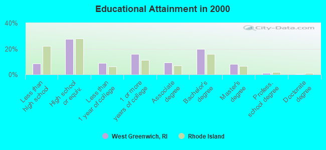
For population 25 years and over in West Greenwich:
- High school or higher: 91.5%
- Bachelor's degree or higher: 29.9%
- Graduate or professional degree: 10.1%
- Unemployed: 4.8%
- Mean travel time to work (commute): 28.8 minutes
| Here: | 9.7 |
| Rhode Island average: | 14.0 |
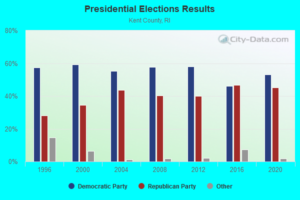
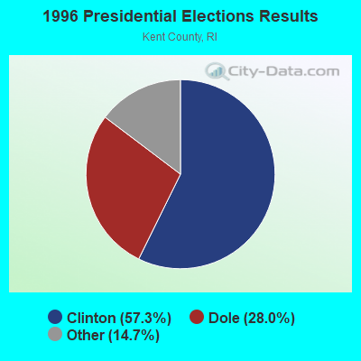
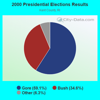
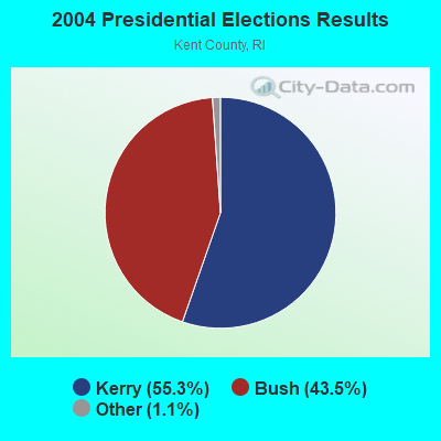
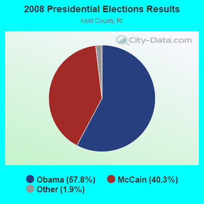
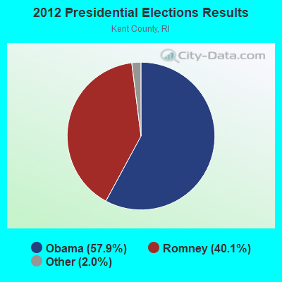

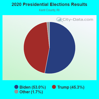
Graphs represent county-level data. Detailed 2008 Election Results
Political contributions by individuals in West Greenwich, RI
Religion statistics for West Greenwich, RI (based on Kent County data)
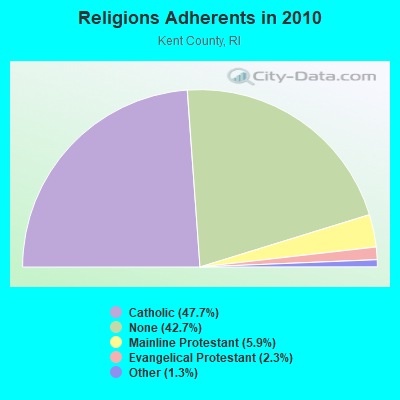
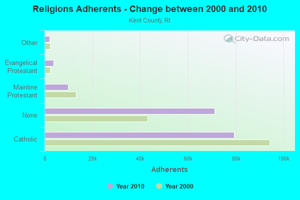
| Religion | Adherents | Congregations |
|---|---|---|
| Catholic | 79,337 | 23 |
| Mainline Protestant | 9,853 | 31 |
| Evangelical Protestant | 3,786 | 21 |
| Other | 2,175 | 11 |
| None | 71,007 | - |
Food Environment Statistics:
| Kent County: | 1.37 / 10,000 pop. |
| Rhode Island: | 1.92 / 10,000 pop. |
| Kent County: | 0.12 / 10,000 pop. |
| State: | 0.05 / 10,000 pop. |
| This county: | 0.89 / 10,000 pop. |
| Rhode Island: | 1.42 / 10,000 pop. |
| Kent County: | 3.09 / 10,000 pop. |
| Rhode Island: | 2.24 / 10,000 pop. |
| Kent County: | 10.04 / 10,000 pop. |
| Rhode Island: | 9.75 / 10,000 pop. |
| This county: | 8.4% |
| Rhode Island: | 7.9% |
| Kent County: | 22.6% |
| Rhode Island: | 22.6% |
| Kent County: | 15.4% |
| State: | 16.3% |
| Businesses in West Greenwich, RI | ||||
| Name | Count | Name | Count | |
|---|---|---|---|---|
| Best Western | 1 | Marriott | 1 | |
| Dunkin Donuts | 3 | Subway | 1 | |
| FedEx | 1 | Super 8 | 1 | |
| GNC | 1 | UPS | 1 | |
| H&R Block | 1 | |||
Strongest AM radio stations in West Greenwich:
- WALE (990 AM; 50 kW; GREENVILLE, RI; Owner: NORTH AMERICAN BROADCASTING CO., INC.)
- WCRN (830 AM; 50 kW; WORCESTER, MA; Owner: CARTER BROADCASTING CORPORATION)
- WEEI (850 AM; 50 kW; BOSTON, MA; Owner: ENTERCOM BOSTON LICENSE, LLC)
- WJJF (1180 AM; daytime; 2 kW; HOPE VALLEY, RI; Owner: CHARLES RIVER BROADCASTING WJJF LICENSE CORPORATION)
- WARV (1590 AM; 5 kW; WARWICK, RI; Owner: BLOUNT COMMUNICATIONS, INC.)
- WRNI (1290 AM; 10 kW; PROVIDENCE, RI; Owner: WRNI FOUNDATION)
- WKOX (1200 AM; 50 kW; FRAMINGHAM, MA; Owner: CAPSTAR TX LIMITED PARTNERSHIP)
- WPRO (630 AM; 5 kW; PROVIDENCE, RI; Owner: CITADEL BROADCASTING COMPANY)
- WRKO (680 AM; 50 kW; BOSTON, MA; Owner: ENTERCOM BOSTON LICENSE, LLC)
- WBIX (1060 AM; 40 kW; NATICK, MA; Owner: LANGER BROADCASTING CORPORATION)
- WNNZ (640 AM; 50 kW; WESTFIELD, MA; Owner: CLEAR CHANNEL BROADCASTING LICENSES, INC.)
- WDDZ (550 AM; 5 kW; PAWTUCKET, RI; Owner: ABC, INC.)
- WSKO (790 AM; 5 kW; PROVIDENCE, RI; Owner: CITADEL BROADCASTING COMPANY)
Strongest FM radio stations in West Greenwich:
- WSKO-FM (99.7 FM; WAKEFIELD-PEACEDALE, RI; Owner: CITADEL BROADCASTING COMPANY)
- WWRX-FM (103.7 FM; WESTERLY, RI; Owner: FNX BROADCASTING OF RHODE ISLAND, LLC)
- WRIU (90.3 FM; KINGSTON, RI; Owner: UNIVERSITY OF RHODE ISLAND)
- WPRO-FM (92.3 FM; PROVIDENCE, RI; Owner: CITADEL BROADCASTING COMPANY)
- WWBB (101.5 FM; PROVIDENCE, RI; Owner: CLEAR CHANNEL BROADCASTING LICENSES, INC.)
- WWLI (105.1 FM; PROVIDENCE, RI; Owner: CITADEL BROADCASTING COMPANY)
- WKKB (100.3 FM; MIDDLETOWN, RI; Owner: CITADEL BROADCASTING COMPANY)
- WHJM (107.7 FM; PAWCATUCK, CT; Owner: FULLER BROADCASTING INTERNATIONAL, LLC)
- WBRU (95.5 FM; PROVIDENCE, RI; Owner: BROWN BROADCASTING SERVICE, INC.)
- WSNE-FM (93.3 FM; TAUNTON, MA; Owner: CAPSTAR TX LIMITED PARTNERSHIP)
- WHJY (94.1 FM; PROVIDENCE, RI; Owner: CAPSTAR TX LIMITED PARTNERSHIP)
- WBMW (106.5 FM; LEDYARD, CT; Owner: RED WOLF BROADCASTING CORPORATION)
- WWKX (106.3 FM; WOONSOCKET, RI; Owner: AAA ENTERTAINMENT LICENSING LLC)
- WXLM (102.3 FM; STONINGTON, CT; Owner: CITADEL BROADCASTING COMPANY)
- WILI-FM (98.3 FM; WILLIMANTIC, CT; Owner: NUTMEG BROADCASTING COMPANY)
- WCTY (97.7 FM; NORWICH, CT; Owner: WICH, INC.)
- WAKX (102.7 FM; NARRAGANSETT PIER, RI; Owner: AAA ENTERTAINMENT LICENSING LLC)
- WBVC (91.1 FM; POMFRET, CT; Owner: POMFRET SCHOOL)
- WCVY (91.5 FM; COVENTRY, RI; Owner: COVENTRY RHODE ISLAND PUBLIC SCHOOLS)
TV broadcast stations around West Greenwich:
- WPXQ (Channel 69; BLOCK ISLAND, RI; Owner: OCEAN STATE TELEVISION, L.L.C.)
- WRIW-LP (Channel 50; PROVIDENCE, RI; Owner: ZGS PROVIDENCE, INC.)
- WNAC-TV (Channel 64; PROVIDENCE, RI; Owner: WNAC, LLC)
- WPRI-TV (Channel 12; PROVIDENCE, RI; Owner: TVL BROADCASTING OF RHODE ISLAND, LLC)
- WHPX (Channel 26; NEW LONDON, CT; Owner: PAXSON HARTFORD LICENSE, INC.)
- WLNE-TV (Channel 6; NEW BEDFORD, MA; Owner: FREEDOM BROADCASTING OF SOUTHERN NEW ENGLAND, INC.)
- WJAR (Channel 10; PROVIDENCE, RI; Owner: OUTLET BROADCASTING, INC.)
- WSBE-TV (Channel 36; PROVIDENCE, RI; Owner: RHODE ISLAND PUBLIC TELECOM. AUTHORITY)
- WUNI (Channel 27; WORCESTER, MA; Owner: ENTRAVISION HOLDINGS, LLC)
- WYDN (Channel 48; WORCESTER, MA; Owner: EDUCATIONAL PUBLIC TV CORPORATION)
- WWDP (Channel 46; NORWELL, MA; Owner: NORWELL TELEVISION, LLC)
- WEDN (Channel 53; NORWICH, CT; Owner: CONNECTICUT PUBLIC BROADCASTING, INC.)
- National Bridge Inventory (NBI) Statistics
- 15Number of bridges
- 131ft / 39.9mTotal length
- $24,456,000Total costs
- 309,611Total average daily traffic
- 39,014Total average daily truck traffic
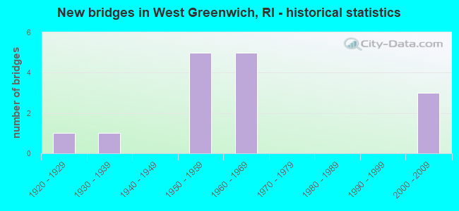
- New bridges - historical statistics
- 11920-1929
- 11930-1939
- 51950-1959
- 51960-1969
- 32000-2009
FCC Registered Cell Phone Towers:
1 (See the full list of FCC Registered Cell Phone Towers in West Greenwich)FCC Registered Antenna Towers:
38 (See the full list of FCC Registered Antenna Towers)FCC Registered Private Land Mobile Towers:
2 (See the full list of FCC Registered Private Land Mobile Towers in West Greenwich, RI)FCC Registered Broadcast Land Mobile Towers:
7 (See the full list of FCC Registered Broadcast Land Mobile Towers)FCC Registered Microwave Towers:
6- W GREENWICH, Hopkins Hill Rd (Lat: 41.620083 Lon: -71.567556), Overall height: 58.8 m, Call Sign: WMR348, Licensee ID: L00127808,
Assigned Frequencies: 2174.80 MHz, Grant Date: 02/22/1995, Expiration Date: 02/01/2001, Cancellation Date: 11/12/1999, Registrant: Snet Cellular Inc, 500 Enterprise Dr, Rocky Hill, CT 06067-3900
- STATION, Lat: 41.683417 Lon: -71.582833, Overall height: 6.1 m, Call Sign: WNTU299,
Assigned Frequencies: 952.443 MHz, 952.443 MHz, Grant Date: 12/13/2017, Expiration Date: 01/31/2028, Certifier: Nghia (Michael) Lac, Registrant: Keller And Heckman LLP, 1001 G Street Nw, Suite 500, Washington, DC 20001, Phone: (202) 434-4100, Fax: (202) 434-4646, Email:
- 55 Technology Way (Lat: 41.656472 Lon: -71.570611), Structure height: 9.1 m, Overall height: 15.2 m, Call Sign: WPND359,
Assigned Frequencies: 928.456 MHz, 952.456 MHz, Grant Date: 04/12/2002, Expiration Date: 03/20/2012, Cancellation Date: 05/26/2012, Phone: (401) 827-5840
- WEST GREENWICH, 689a Hopkins Hill Rd (Lat: 41.622194 Lon: -71.567028), Type: Mast, Structure height: 55.2 m, Overall height: 55.5 m, Call Sign: WLL933,
Assigned Frequencies: 6785.00 MHz, 6805.00 MHz, Grant Date: 01/11/2011, Expiration Date: 02/01/2021, Cancellation Date: 07/22/2016, Certifier: Carol L Tacker, Registrant: At&t Mobility LLC, 3300 E. Renner Road, B3132, Richardson, TX 75082, Phone: (855) 699-7073, Fax: (972) 907-1131, Email:
- WEST GREENWICH 2, 280 Victory Highway (Lat: 41.639611 Lon: -71.687250), Type: Mast, Structure height: 54.9 m, Overall height: 58.8 m, Call Sign: WPON316,
Assigned Frequencies: 6595.00 MHz, 10603.1 MHz, Grant Date: 03/02/2010, Expiration Date: 03/27/2020, Cancellation Date: 05/05/2017, Certifier: Carol L Tacker, Registrant: At&t Mobility LLC, 3300 E. Renner Road, B3132, Richardson, TX 75082, Phone: (855) 699-7073, Fax: (972) 907-1131, Email:
- TS-0000030535, 40 Technology Way (Lat: 41.660167 Lon: -71.564861), Type: Building, Structure height: 29 m, Call Sign: WRKW913,
Assigned Frequencies: 11405.0 MHz, 11405.0 MHz, 11405.0 MHz, 11405.0 MHz, 11405.0 MHz, 11405.0 MHz, Grant Date: 02/24/2021, Expiration Date: 02/24/2031, Certifier: Michael Connors, Registrant: Micronet Communications, Inc., 812 Lexington Dr, Plano, TX 75075, Phone: (972) 422-7200, Email:
FCC Registered Amateur Radio Licenses:
45 (See the full list of FCC Registered Amateur Radio Licenses in West Greenwich)FAA Registered Aircraft:
6- Aircraft: JAMES GILLIATT KITFOX SERIES 7 (Category: Land, Seats: 2, Weight: Up to 12,499 Pounds), Engine: Reciprocating
N-Number: 279JG, N279JG, N-279JG, Serial Number: S70301020, Certificate Issue Date: 09/26/2014
Registrant (Individual): James G Gilliatt, 1030 Fish Hill Rd, West Greenwich, RI 02817 - Aircraft: CESSNA 180 (Category: Land, Seats: 4, Weight: Up to 12,499 Pounds, Speed: 121 mph), Engine: CONT MOTOR O-470 SERIES (230 HP) (Reciprocating)
N-Number: 4644A, N4644A, N-4644A, Serial Number: 32241, Year manufactured: 1956, Airworthiness Date: 01/20/1956, Certificate Issue Date: 06/10/2020
Registrant (Individual): Lauren M Lee, 76 Parkside Dr, West Greenwich, RI 02817 - Aircraft: DUMONT GREG CHALLENGER II (Category: Land, Seats: 2, Weight: Up to 12,499 Pounds), Engine: Reciprocating
N-Number: 493CG, N493CG, N-493CG, Serial Number: CH2-0505-2634, Certificate Issue Date: 05/28/2013
Registrant (Individual): Greg N Dumont, 30 Nipmuc Trl, West Greenwich, RI 02817 - Aircraft: CHAMPION 7KCAB (Category: Land, Seats: 2, Weight: Up to 12,499 Pounds, Speed: 90 mph), Engine: AMA/EXPR UNKNOWN ENG (Reciprocating)
N-Number: 5063X, N5063X, N-5063X, Serial Number: 145, Year manufactured: 1968, Airworthiness Date: 03/18/1976, Certificate Issue Date: 01/27/2016
Registrant (Partnership): James W Grundy, 796 C Nooseneck Hill Rd, West Greenwich, RI 02817, Other Owners: Beverly J Grundy - Aircraft: CESSNA 172P (Category: Land, Seats: 4, Weight: Up to 12,499 Pounds), Engine: LYCOMING 0-320 SERIES (180 HP) (Reciprocating)
N-Number: 54306, N54306, N-54306, Serial Number: 17274951, Year manufactured: 1981, Airworthiness Date: 05/05/1981, Certificate Issue Date: 12/16/2013
Registrant (Individual): Patrick J Aiken, 17 Club House Rd, West Greenwich, RI 02817 - Aircraft: CHAMPION 7KCAB (Category: Land, Seats: 2, Weight: Up to 12,499 Pounds, Speed: 90 mph), Engine: LYCOMING IO-320 SERIES (150 HP) (Reciprocating)
N-Number: 7544F, N7544F, N-7544F, Serial Number: 284-70, Year manufactured: 1969, Airworthiness Date: 11/04/1969, Certificate Issue Date: 05/29/2014
Registrant (Partnership): James W Grundy, 796 Nooseneck Hill Rd # C, West Greenwich, RI 02817, Other Owners: Beverly J Grundy
2003 - 2018 National Fire Incident Reporting System (NFIRS) incidents
- Fire incident types reported to NFIRS in West Greenwich, RI
- 7741.4%Outside Fires
- 6233.3%Structure Fires
- 3116.7%Mobile Property/Vehicle Fires
- 168.6%Other
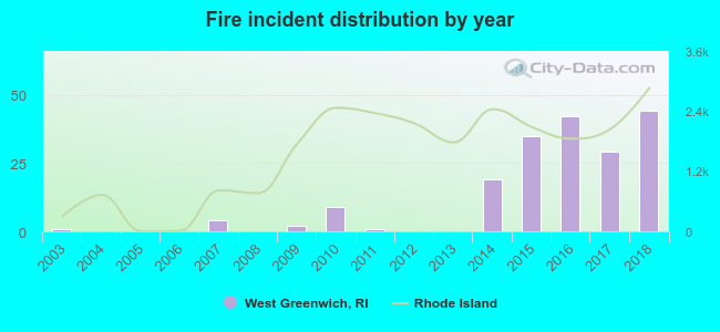 According to the data from the years 2003 - 2018 the average number of fires per year is 12. The highest number of reported fire incidents - 44 took place in 2018, and the least - 0 in 2004. The data has a growing trend.
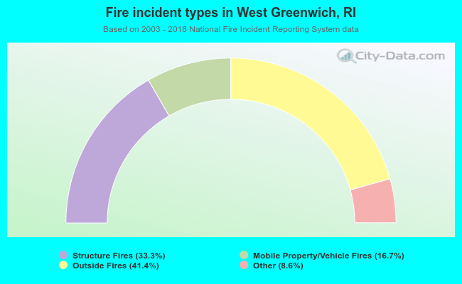 When looking into fire subcategories, the most incidents belonged to: Outside Fires (41.4%), and Structure Fires (33.3%).
- 87.1%Fuel oil, kerosene, etc.
- 5.0%Wood
- 4.0%Bottled, tank, or LP gas
- 2.8%Electricity
- 0.8%Utility gas
- 0.4%No fuel used
- 69.7%Fuel oil, kerosene, etc.
- 14.9%Bottled, tank, or LP gas
- 7.7%Electricity
- 7.7%Wood
West Greenwich compared to Rhode Island state average:
- Unemployed percentage significantly below state average.
- Black race population percentage significantly below state average.
- Hispanic race population percentage significantly below state average.
- Foreign-born population percentage significantly below state average.
- Renting percentage below state average.
- Length of stay since moving in significantly above state average.
- Number of rooms per house significantly below state average.
- House age significantly below state average.
West Greenwich on our top lists:
- #4 on the list of "Top 101 cities with largest percentage of males in industries: drugs, sundries, and chemical and allied products merchant wholesalers (population 5,000+)"
- #10 on the list of "Top 101 cities with largest percentage of females in occupations: architects, surveyors, and cartographers (population 5,000+)"
- #11 on the list of "Top 101 cities with largest percentage of males in industries: miscellaneous manufacturing (population 5,000+)"
- #15 on the list of "Top 101 cities with largest percentage of females in occupations: registered nurses (population 5,000+)"
- #16 on the list of "Top 101 cities with largest percentage of females in occupations: financial managers (population 5,000+)"
- #17 on the list of "Top 101 cities with largest percentage of females in industries: recyclable material merchant wholesalers (population 5,000+)"
- #21 on the list of "Top 101 cities with largest percentage of males in industries: recyclable material merchant wholesalers (population 5,000+)"
- #21 on the list of "Top 101 cities with largest percentage of males in industries: u. s. postal service (population 5,000+)"
- #23 on the list of "Top 101 cities with largest percentage of males in occupations: special education teachers (population 5,000+)"
- #25 on the list of "Top 101 cities with largest percentage of males in occupations: occupational and physical therapist assistants and aides (population 5,000+)"
- #34 on the list of "Top 101 cities with largest percentage of males in occupations: bus drivers (population 5,000+)"
- #52 on the list of "Top 101 cities with largest percentage of females in industries: electrical and electronic goods merchant wholesalers (population 5,000+)"
- #59 on the list of "Top 101 cities with largest percentage of females in industries: music stores (population 5,000+)"
- #80 on the list of "Top 101 cities with the largest percentage of people in other workers' dormitories (population 1,000+)"
- #89 on the list of "Top 101 cities with largest percentage of males in industries: health and personal care, except drug, stores (population 5,000+)"
- #96 on the list of "Top 101 cities with largest percentage of females in industries: miscellaneous nondurable goods merchant wholesalers (population 5,000+)"
- #3 on the list of "Top 101 counties with the lowest Nitrogen Dioxide air pollution readings in 2012 (ppm)"
- #8 on the list of "Top 101 counties with the lowest Particulate Matter (PM10) Annual air pollution readings in 2012 (µg/m3)"
- #14 on the list of "Top 101 counties with the lowest percentage of residents relocating from foreign countries between 2010 and 2011"
- #17 on the list of "Top 101 counties with the lowest total withdrawal of fresh water for public supply (pop. 50,000+)"
- #30 on the list of "Top 101 counties with the highest percentage of residents that smoked 100+ cigarettes in their lives"

|
|
Total of 44 patent applications in 2008-2024.