West Warwick, Rhode Island

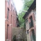
West Warwick: saw mill by the river walk.i am from ms so this and many other pic i have is so nice.

West Warwick: WEST WARWICK TOWN HALL
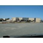
West Warwick: WEST WARWICK HIGH SCHOOL

West Warwick: saw mill by the river walk.i am from ms so this and many other pic i have is so nice.
West Warwick: saw mill by the river walk.i am from ms so this and many other pic i have is so nice.
- add
your
Submit your own pictures of this place and show them to the world
- OSM Map
- General Map
- Google Map
- MSN Map
| Males: 14,329 | |
| Females: 15,459 |
| Median resident age: | 36.4 years |
| Rhode Island median age: | 36.7 years |
Zip codes: 02893.
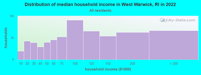
| West Warwick: | $70,847 |
| RI: | $81,854 |
Estimated per capita income in 2022: $38,587 (it was $20,250 in 2000)
West Warwick CDP income, earnings, and wages data
Estimated median house or condo value in 2022: $310,373 (it was $107,000 in 2000)
| West Warwick: | $310,373 |
| RI: | $383,900 |
Mean prices in 2022: all housing units: $378,490; detached houses: $398,338; townhouses or other attached units: $357,193; in 2-unit structures: $303,020; in 3-to-4-unit structures: $233,611; in 5-or-more-unit structures: $254,381; mobile homes: $77,021
Detailed information about poverty and poor residents in West Warwick, RI


- 27,30692.3%White alone
- 9183.1%Hispanic
- 4851.6%Two or more races
- 4071.4%Asian alone
- 3061.0%Black alone
- 920.3%American Indian alone
- 600.2%Other race alone
- 70.02%Native Hawaiian and Other
Pacific Islander alone
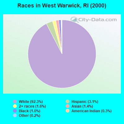
Races in West Warwick detailed stats: ancestries, foreign born residents, place of birth
According to our research of Rhode Island and other state lists, there were 52 registered sex offenders living in West Warwick, Rhode Island as of April 27, 2024.
The ratio of all residents to sex offenders in West Warwick is 573 to 1.
Type |
2009 |
2010 |
2011 |
2012 |
2013 |
2014 |
2015 |
2016 |
2017 |
2018 |
2019 |
2020 |
2021 |
2022 |
|---|---|---|---|---|---|---|---|---|---|---|---|---|---|---|
| Murders (per 100,000) | 0 (0.0) | 0 (0.0) | 0 (0.0) | 1 (3.4) | 0 (0.0) | 0 (0.0) | 1 (3.5) | 0 (0.0) | 0 (0.0) | 0 (0.0) | 0 (0.0) | 0 (0.0) | 1 (3.3) | 0 (0.0) |
| Rapes (per 100,000) | 17 (58.1) | 17 (58.2) | 14 (48.0) | 12 (41.3) | 23 (79.8) | 11 (38.0) | 15 (52.0) | 16 (55.6) | 17 (59.0) | 24 (84.3) | 14 (48.5) | 14 (48.6) | 16 (53.4) | 15 (48.0) |
| Robberies (per 100,000) | 19 (64.9) | 13 (44.5) | 12 (41.2) | 6 (20.7) | 11 (38.2) | 11 (38.0) | 12 (41.6) | 10 (34.7) | 9 (31.3) | 7 (24.6) | 2 (6.9) | 3 (10.4) | 7 (23.4) | 7 (22.4) |
| Assaults (per 100,000) | 29 (99.0) | 36 (123.3) | 47 (161.2) | 48 (165.2) | 19 (65.9) | 39 (134.8) | 39 (135.3) | 34 (118.1) | 40 (138.9) | 34 (119.4) | 38 (131.7) | 44 (152.6) | 36 (120.1) | 27 (86.5) |
| Burglaries (per 100,000) | 132 (450.8) | 154 (527.6) | 185 (634.5) | 158 (543.8) | 128 (444.2) | 97 (335.2) | 102 (353.8) | 80 (278.0) | 94 (326.5) | 68 (238.9) | 58 (201.1) | 55 (190.8) | 45 (150.2) | 39 (124.9) |
| Thefts (per 100,000) | 427 (1,458) | 434 (1,487) | 422 (1,447) | 388 (1,335) | 332 (1,152) | 259 (895.1) | 270 (936.6) | 225 (781.9) | 197 (684.3) | 213 (748.3) | 161 (558.1) | 138 (478.7) | 139 (463.9) | 144 (461.1) |
| Auto thefts (per 100,000) | 37 (126.4) | 40 (137.0) | 36 (123.5) | 40 (137.7) | 24 (83.3) | 29 (100.2) | 30 (104.1) | 27 (93.8) | 28 (97.3) | 24 (84.3) | 19 (65.9) | 28 (97.1) | 24 (80.1) | 34 (108.9) |
| Arson (per 100,000) | 5 (17.1) | 14 (48.0) | 5 (17.1) | 8 (27.5) | 13 (45.1) | 8 (27.6) | 8 (27.8) | 3 (10.4) | 6 (20.8) | 3 (10.5) | 2 (6.9) | 6 (20.8) | 2 (6.7) | 4 (12.8) |
| City-Data.com crime index | 185.7 | 192.0 | 195.2 | 181.7 | 172.3 | 136.1 | 158.7 | 136.8 | 142.4 | 152.1 | 108.9 | 112.8 | 115.9 | 98.3 |
The City-Data.com crime index weighs serious crimes and violent crimes more heavily. Higher means more crime, U.S. average is 246.1. It adjusts for the number of visitors and daily workers commuting into cities.
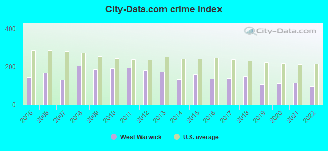
Crime rate in West Warwick detailed stats: murders, rapes, robberies, assaults, burglaries, thefts, arson
Full-time law enforcement employees in 2021, including police officers: 52 (44 officers - 41 male; 3 female).
| Officers per 1,000 residents here: | 1.47 |
| Rhode Island average: | 2.27 |
 Recent articles from our blog. Our writers, many of them Ph.D. graduates or candidates, create easy-to-read articles on a wide variety of topics.


Latest news from West Warwick, RI collected exclusively by city-data.com from local newspapers, TV, and radio stations
Ancestries: Italian (22.7%), Irish (19.1%), French (18.5%), English (11.9%), Portuguese (10.0%), French Canadian (9.4%).
Current Local Time: EST time zone
Incorporated in 1913
Elevation: 130 feet
Land area: 7.93 square miles.
Population density: 3,755 people per square mile (average).
2,112 residents are foreign born (3.7% Europe, 1.6% Latin America, 1.3% Asia).
| This place: | 7.1% |
| Rhode Island: | 11.4% |
| West Warwick CDP: | 2.7% ($2,866) |
| Rhode Island: | 1.9% ($2,507) |
Nearest city with pop. 50,000+: Warwick, RI  (5.4 miles , pop. 85,808).
Nearest city with pop. 200,000+: Boston, MA (48.1 miles , pop. 589,141).
Nearest city with pop. 1,000,000+: Bronx, NY (136.0 miles , pop. 1,332,650).
Nearest cities:
), ), Latitude: 41.70 N, Longitude: 71.52 W
Daytime population change due to commuting: -5,195 (-17.6%)
Workers who live and work in this place: 2,515 (17.3%)
Area code: 401
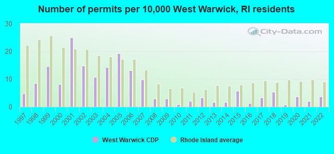
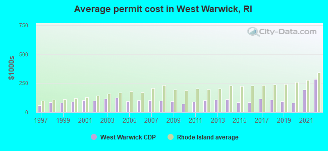
Single-family new house construction building permits:
- 2022: 11 buildings, average cost: $285,600
- 2021: 6 buildings, average cost: $193,800
- 2020: 11 buildings, average cost: $81,600
- 2019: 2 buildings, average cost: $96,200
- 2018: 16 buildings, average cost: $110,000
- 2017: 10 buildings, average cost: $119,300
- 2016: 4 buildings, average cost: $86,100
- 2015: 17 buildings, average cost: $84,700
- 2014: 5 buildings, average cost: $110,800
- 2013: 5 buildings, average cost: $107,500
- 2012: 10 buildings, average cost: $104,400
- 2011: 6 buildings, average cost: $92,000
- 2010: 3 buildings, average cost: $74,400
- 2009: 9 buildings, average cost: $96,700
- 2008: 9 buildings, average cost: $99,700
- 2007: 29 buildings, average cost: $103,800
- 2006: 39 buildings, average cost: $105,000
- 2005: 57 buildings, average cost: $96,000
- 2004: 42 buildings, average cost: $126,300
- 2003: 32 buildings, average cost: $119,300
- 2002: 44 buildings, average cost: $100,000
- 2001: 74 buildings, average cost: $104,900
- 2000: 24 buildings, average cost: $90,000
- 1999: 43 buildings, average cost: $83,400
- 1998: 25 buildings, average cost: $87,400
- 1997: 14 buildings, average cost: $59,200
| Here: | 2.9% |
| Rhode Island: | 3.3% |
- Health care (9.6%)
- Accommodation & food services (7.6%)
- Finance & insurance (6.0%)
- Educational services (5.9%)
- Construction (5.5%)
- Miscellaneous manufacturing (4.5%)
- Public administration (4.2%)
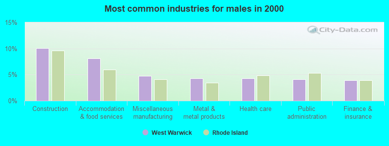
- Construction (10.1%)
- Accommodation & food services (8.1%)
- Miscellaneous manufacturing (4.8%)
- Metal & metal products (4.3%)
- Health care (4.3%)
- Public administration (4.1%)
- Finance & insurance (3.9%)
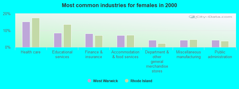
- Health care (15.2%)
- Educational services (8.4%)
- Finance & insurance (8.2%)
- Accommodation & food services (7.1%)
- Department & other general merchandise stores (4.3%)
- Miscellaneous manufacturing (4.3%)
- Public administration (4.2%)
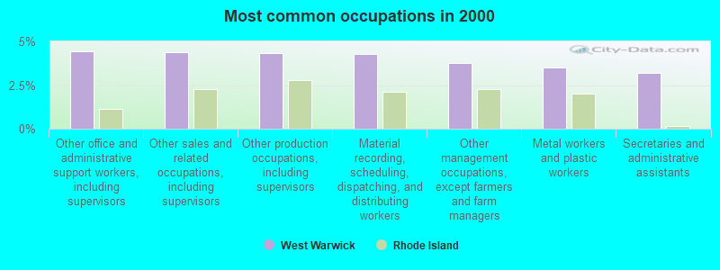
- Other office and administrative support workers, including supervisors (4.4%)
- Other sales and related occupations, including supervisors (4.4%)
- Other production occupations, including supervisors (4.3%)
- Material recording, scheduling, dispatching, and distributing workers (4.3%)
- Other management occupations, except farmers and farm managers (3.8%)
- Metal workers and plastic workers (3.5%)
- Secretaries and administrative assistants (3.2%)
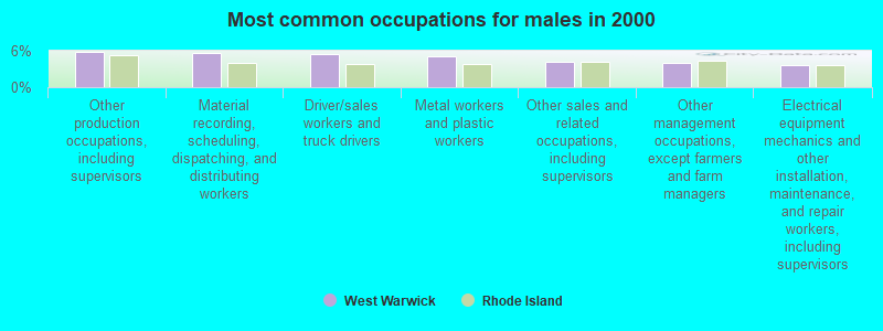
- Other production occupations, including supervisors (5.9%)
- Material recording, scheduling, dispatching, and distributing workers (5.6%)
- Driver/sales workers and truck drivers (5.5%)
- Metal workers and plastic workers (5.2%)
- Other sales and related occupations, including supervisors (4.2%)
- Other management occupations, except farmers and farm managers (4.1%)
- Electrical equipment mechanics and other installation, maintenance, and repair workers, including supervisors (3.7%)

- Other office and administrative support workers, including supervisors (7.1%)
- Secretaries and administrative assistants (6.4%)
- Cashiers (5.2%)
- Other sales and related occupations, including supervisors (4.6%)
- Customer service representatives (4.2%)
- Retail sales workers, except cashiers (4.1%)
- Preschool, kindergarten, elementary, and middle school teachers (3.5%)
Average climate in West Warwick, Rhode Island
Based on data reported by over 4,000 weather stations


|
|

(lower is better)
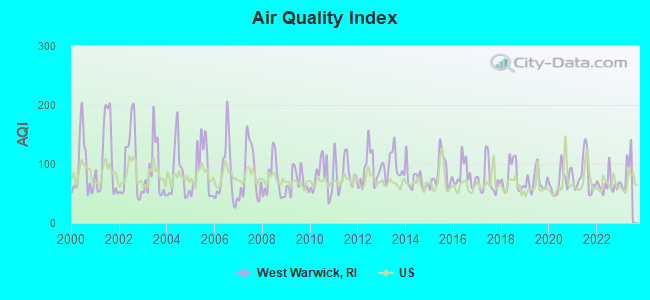
Air Quality Index (AQI) level in 2022 was 65.2. This is about average.
| City: | 65.2 |
| U.S.: | 72.6 |
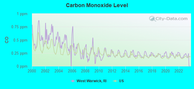
Carbon Monoxide (CO) [ppm] level in 2022 was 0.196. This is better than average. Closest monitor was 9.8 miles away from the city center.
| City: | 0.196 |
| U.S.: | 0.251 |
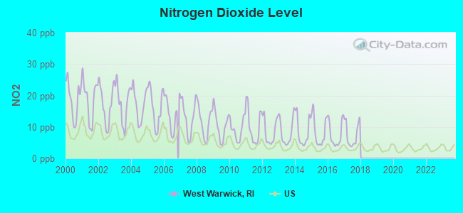
Nitrogen Dioxide (NO2) [ppb] level in 2017 was 7.52. This is significantly worse than average. Closest monitor was 5.2 miles away from the city center.
| City: | 7.52 |
| U.S.: | 5.11 |
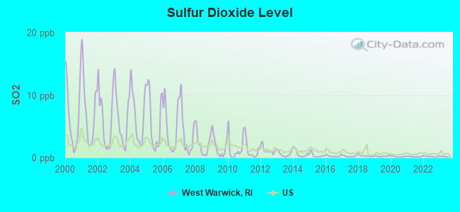
Sulfur Dioxide (SO2) [ppb] level in 2022 was 0.179. This is significantly better than average. Closest monitor was 5.2 miles away from the city center.
| City: | 0.179 |
| U.S.: | 1.515 |
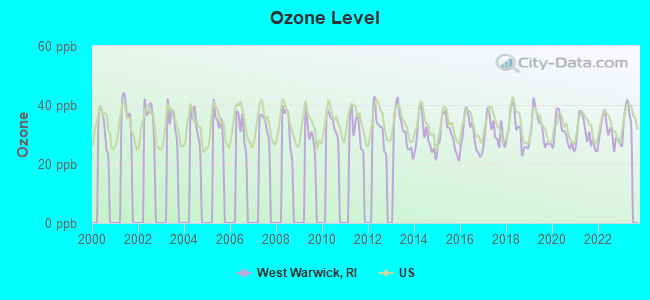
Ozone [ppb] level in 2022 was 30.8. This is about average. Closest monitor was 4.4 miles away from the city center.
| City: | 30.8 |
| U.S.: | 33.3 |
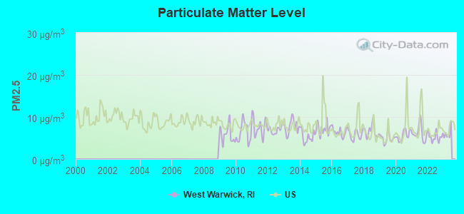
Particulate Matter (PM2.5) [µg/m3] level in 2022 was 5.25. This is significantly better than average. Closest monitor was 4.0 miles away from the city center.
| City: | 5.25 |
| U.S.: | 8.11 |
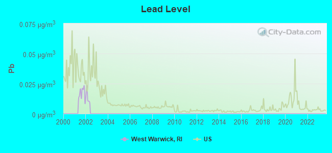
Lead (Pb) [µg/m3] level in 2001 was 0.0167. This is significantly worse than average. Closest monitor was 6.0 miles away from the city center.
| City: | 0.0167 |
| U.S.: | 0.0093 |
Tornado activity:
West Warwick-area historical tornado activity is near Rhode Island state average. It is 50% smaller than the overall U.S. average.
On 6/9/1953, a category F4 (max. wind speeds 207-260 mph) tornado 41.2 miles away from the West Warwick place center killed 90 people and injured 1228 people and caused between $50,000,000 and $500,000,000 in damages.
On 6/9/1953, a category F3 (max. wind speeds 158-206 mph) tornado 29.0 miles away from the place center injured 17 people and caused between $500,000 and $5,000,000 in damages.
Earthquake activity:
West Warwick-area historical earthquake activity is significantly above Rhode Island state average. It is 73% smaller than the overall U.S. average.On 10/7/1983 at 10:18:46, a magnitude 5.3 (5.1 MB, 5.3 LG, 5.1 ML, Class: Moderate, Intensity: VI - VII) earthquake occurred 211.4 miles away from West Warwick center
On 4/20/2002 at 10:50:47, a magnitude 5.3 (5.3 ML, Depth: 3.0 mi) earthquake occurred 223.2 miles away from the city center
On 4/20/2002 at 10:50:47, a magnitude 5.2 (5.2 MB, 4.2 MS, 5.2 MW, 5.0 MW) earthquake occurred 222.2 miles away from West Warwick center
On 1/19/1982 at 00:14:42, a magnitude 4.7 (4.5 MB, 4.7 MD, 4.5 LG, Class: Light, Intensity: IV - V) earthquake occurred 124.3 miles away from West Warwick center
On 10/16/2012 at 23:12:25, a magnitude 4.7 (4.7 ML, Depth: 10.0 mi) earthquake occurred 138.1 miles away from West Warwick center
On 8/22/1992 at 12:20:32, a magnitude 4.8 (4.8 MB, 3.8 MS, 4.7 LG, Depth: 6.2 mi) earthquake occurred 190.5 miles away from the city center
Magnitude types: regional Lg-wave magnitude (LG), body-wave magnitude (MB), duration magnitude (MD), local magnitude (ML), surface-wave magnitude (MS), moment magnitude (MW)
Natural disasters:
The number of natural disasters in Kent County (17) is near the US average (15).Major Disasters (Presidential) Declared: 8
Emergencies Declared: 8
Causes of natural disasters: Hurricanes: 6, Blizzards: 3, Snowstorms: 3, Floods: 2, Storms: 2, Winter Storms: 2, Snow: 1, Snowfall: 1, Tropical Storm: 1, Water Main Break: 1, Wind: 1, Other: 1 (Note: some incidents may be assigned to more than one category).
Main business address for: ASTRO MED INC /NEW/ (COMPUTER PERIPHERAL EQUIPMENT, NEC), AMTROL INC /RI/ (FABRICATED PLATE WORK (BOILER SHOPS)).
Hospitals and medical centers in West Warwick:
Other hospitals and medical centers near West Warwick:
- ODYSSEY HEALTHCARE OF RHODE ISLAND (Hospital, about 2 miles away; WARWICK, RI)
- DIALYSIS CENTER OF WEST WARWICK (Dialysis Facility, about 2 miles away; WARWICK, RI)
- LAUREL FOSTER HOME (Nursing Home, about 2 miles away; COVENTRY, RI)
- VNA OF CARE NEW ENGLAND (Home Health Center, about 2 miles away; WARWICK, RI)
- KENT REGENCY CENTER (Nursing Home, about 3 miles away; WARWICK, RI)
- RIVERVIEW HEALTHCARE COMMUNITY (Nursing Home, about 3 miles away; COVENTRY, RI)
- RIVERVIEW NURSING HOME (Nursing Home, about 3 miles away; COVENTRY, RI)
Amtrak stations near West Warwick:
- 10 miles: PROVIDENCE (100 GASPEE ST.) . Services: ticket office, fully wheelchair accessible, enclosed waiting area, public restrooms, public payphones, snack bar, ATM, paid short-term parking, paid long-term parking, call for car rental service, taxi stand, public transit connection.
- 16 miles: KINGSTON (WEST KINGSTON, FAIRGROUNDS RD.) . Services: ticket office, enclosed waiting area, public restrooms, public payphones, free short-term parking, free long-term parking, call for car rental service, call for taxi service, public transit connection.
Colleges/universities with over 2000 students nearest to West Warwick:
- Community College of Rhode Island (about 3 miles; Warwick, RI; Full-time enrollment: 10,500)
- New England Institute of Technology (about 4 miles; East Greenwich, RI; FT enrollment: 3,183)
- Johnson & Wales University-Providence (about 10 miles; Providence, RI; FT enrollment: 10,898)
- Rhode Island College (about 10 miles; Providence, RI; FT enrollment: 7,189)
- Rhode Island School of Design (about 11 miles; Providence, RI; FT enrollment: 2,714)
- Brown University (about 11 miles; Providence, RI; FT enrollment: 8,458)
- Providence College (about 11 miles; Providence, RI; FT enrollment: 4,312)
Public high school in West Warwick:
- WEST WARWICK HIGH SCHOOL (Location: 1 WEBSTER KNIGHT DRIVE, Grades: 9-12)
Private high school in West Warwick:
Public elementary/middle schools in West Warwick:
- JOHN F. DEERING MIDDLE (Students: 854, Location: 2 WEBSTER KNIGHT DRIVE, Grades: 5-8)
- WAKEFIELD HILLS EL. SCHOOL (Students: 443, Location: 505 WAKEFIELD STREET, Grades: PK-4)
- GREENBUSH ELEMENTARY SCHOOL (Students: 437, Location: 127 GREENBUSH ROAD, Grades: PK-4)
- JOHN F. HORGAN SCHOOL (Students: 433, Location: 124 PROVIDENCE STREET, Grades: KG-4)
Private elementary/middle schools in West Warwick:
User-submitted facts and corrections:
- New school as of last year in the West Warwick area. It is called Wakefield Hills and is an elementary school located on Wakefield Street. I do not know the population of students there or what grade it goes up to, but it is brand new.
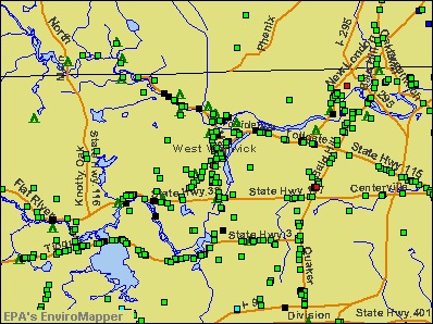
Points of interest:
Notable locations in West Warwick: Midville Country Club (A), West Warwick Country Club (B), Warwick Musical Theatre (C), Robert H Champlin Memorial Library (D), West Warwick Town Hall (E), West Warwick Public Library (F), West Warwick Police Department (G), West Warwick Fire Department Station 4 (H), West Warwick Fire Department Station 3 (I), West Warwick Fire Department Station 2 (J), West Warwick Fire Department Station 1 Headquarters (K), Tides Family Services Center (L), Joyful Noise Day Care Center (M), Crompton Free Library (N), Arctic Center Child Development Center (O). Display/hide their locations on the map
Shopping Center: Cowessett Corners Shopping Center (1). Display/hide its location on the map
Main business address in West Warwick include: ASTRO MED INC /NEW/ (A), AMTROL INC /RI/ (B). Display/hide their locations on the map
Churches in West Warwick include: Riverpoint Congregational Church (A), Emanuel Lutheran Church (B), West Warwick Church of God (C), Phenix Baptist Church (D), Christ the King Religious Church (E), Bethesda Christian Fellowship (F), Saint John the Baptist Church (G), Saint Marys Church (H). Display/hide their locations on the map
Cemeteries: Notre Dame Cemetery (1), Saint Marys Cemetery (2), Saint Marys Crompton Rectory Cemetery (3). Display/hide their locations on the map
Lakes and reservoirs: Matteson Pond (A), Conley Pond (B), Natick Pond (C), Flat Top Pond (D), Natick Pond (E), Pawtuxet River-South Branch (F), Pawtuxet River (G). Display/hide their locations on the map
Streams, rivers, and creeks: Lippitt Brook (A), Hawkinson Brook (B), Cedar Brook (C), South Branch Pawtuxet River (D). Display/hide their locations on the map
Hotels: Gourmet Traveler (99 Pulaski), Comfort Suites West Warwick (10 Keyes Ways), Springhill Suites by Marriott (14 James P Murphy Ind H), Extended Stay America (1200 Division Road), SpringHill Suites Warwick (14 J P Murphy Highway).
Birthplace of: Chuck Palumbo - Professional wrestler, Ann Hood - Novelist, Arthur Pope - Archaeologist, Mike Roarke - Baseball player and coach, Bob Wylie - Football player, Tom Garrick - Basketball player-coach, William J. Murphy (Rhode Island politician) - Politician, Frank Maznicki - Football player.
Drinking water stations with addresses in West Warwick and their reported violations in the past:
KENT COUNTY WATER AUTHORITY (Population served: 88,779, Purch surface water):Past health violations:MIDVILLE GOLF COURSE (Population served: 200, Groundwater):Past monitoring violations:
- MCL, Acute (TCR) - In SEP-2013, Contaminant: Coliform. Follow-up actions: St Boil Water Order (SEP-24-2013), St Public Notif requested (SEP-24-2013), St Violation/Reminder Notice (SEP-24-2013), St Formal NOV issued (SEP-24-2013), St Compliance achieved (SEP-27-2013), St Public Notif received (SEP-27-2013)
- 2 regular monitoring violations
Past monitoring violations:NUTZ (Population served: 50, Groundwater):
- 3 routine major monitoring violations
Past monitoring violations:
- 7 routine major monitoring violations
| This place: | 2.4 people |
| Rhode Island: | 2.5 people |
| This place: | 61.6% |
| Whole state: | 65.3% |
| This place: | 7.7% |
| Whole state: | 5.7% |
Likely homosexual households (counted as self-reported same-sex unmarried-partner households)
- Lesbian couples: 0.3% of all households
- Gay men: 0.2% of all households
| This place: | 11.2% |
| Whole state: | 11.9% |
| This place: | 4.3% |
| Whole state: | 5.4% |
People in group quarters in West Warwick in 2000:
- 116 people in nursing homes
- 43 people in training schools for juvenile delinquents
- 15 people in homes for the mentally retarded
- 8 people in homes for the mentally ill
- 5 people in religious group quarters
Banks with branches in West Warwick (2011 data):
- Centreville Savings Bank: at 1218 Main Street, branch established on 1888/01/01. Info updated 2006/11/03: Bank assets: $965.6 mil, Deposits: $725.3 mil, local headquarters, positive income, 6 total offices
- Metlife Bank, National Association: Call Center Branch at 1600 Division Rd, branch established on 2001/08/14. Info updated 2011/03/09: Bank assets: $25,513.6 mil, Deposits: $10,507.5 mil, headquarters in Convent Station, NJ, negative income in the last year, Mortgage Lending Specialization, 3 total offices, Holding Company: Metlife, Inc.
- Bank of America, National Association: Arctic Branch at 5 Washington Street, branch established on 1924/07/23. Info updated 2009/11/18: Bank assets: $1,451,969.3 mil, Deposits: $1,077,176.8 mil, headquarters in Charlotte, NC, positive income, 5782 total offices, Holding Company: Bank Of America Corporation
- RBS Citizens, National Association: West Warwick Branch at 1220 Main Street, branch established on 1973/02/01. Info updated 2007/09/19: Bank assets: $106,940.6 mil, Deposits: $75,690.2 mil, headquarters in Providence, RI, positive income, 1135 total offices, Holding Company: Uk Financial Investments Limited
For population 15 years and over in West Warwick:
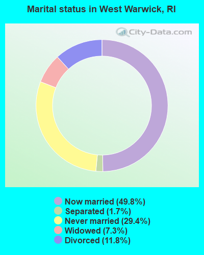
- Never married: 29.4%
- Now married: 49.8%
- Separated: 1.7%
- Widowed: 7.3%
- Divorced: 11.8%
For population 25 years and over in West Warwick:
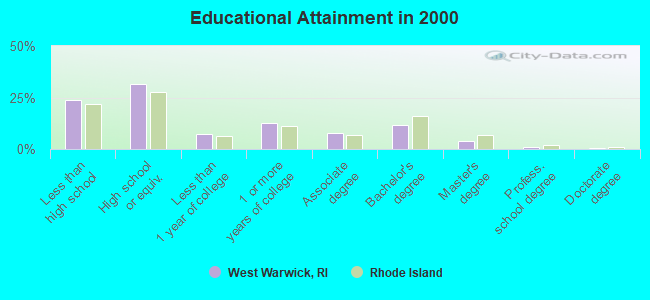
- High school or higher: 76.2%
- Bachelor's degree or higher: 16.7%
- Graduate or professional degree: 5.0%
- Unemployed: 5.5%
- Mean travel time to work (commute): 21.3 minutes
| Here: | 12.3 |
| Rhode Island average: | 14.0 |
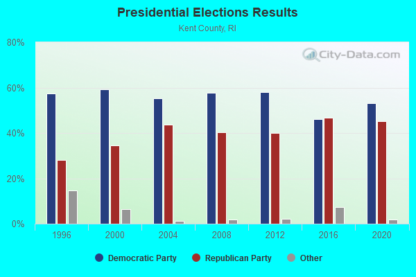
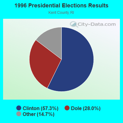
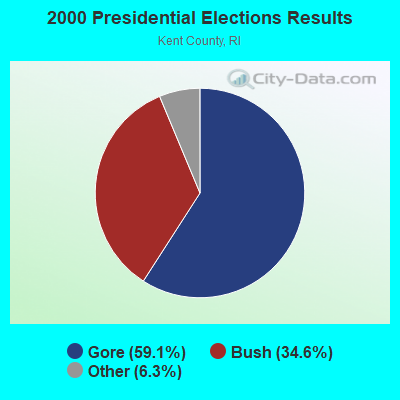


Graphs represent county-level data. Detailed 2008 Election Results
Religion statistics for West Warwick, RI (based on Kent County data)
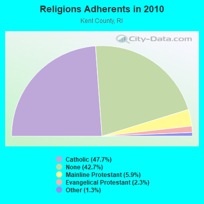
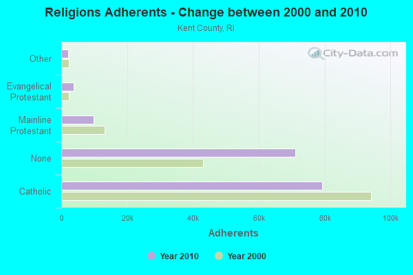
| Religion | Adherents | Congregations |
|---|---|---|
| Catholic | 79,337 | 23 |
| Mainline Protestant | 9,853 | 31 |
| Evangelical Protestant | 3,786 | 21 |
| Other | 2,175 | 11 |
| None | 71,007 | - |
Food Environment Statistics:
| Kent County: | 1.37 / 10,000 pop. |
| Rhode Island: | 1.92 / 10,000 pop. |
| Kent County: | 0.12 / 10,000 pop. |
| Rhode Island: | 0.05 / 10,000 pop. |
| Here: | 0.89 / 10,000 pop. |
| Rhode Island: | 1.42 / 10,000 pop. |
| This county: | 3.09 / 10,000 pop. |
| Rhode Island: | 2.24 / 10,000 pop. |
| Kent County: | 10.04 / 10,000 pop. |
| State: | 9.75 / 10,000 pop. |
| This county: | 8.4% |
| Rhode Island: | 7.9% |
| Kent County: | 22.6% |
| Rhode Island: | 22.6% |
| This county: | 15.4% |
| Rhode Island: | 16.3% |
| Businesses in West Warwick, RI | ||||
| Name | Count | Name | Count | |
|---|---|---|---|---|
| Advance Auto Parts | 1 | H&R Block | 1 | |
| Ashley Furniture | 1 | KFC | 1 | |
| CVS | 3 | Lane Furniture | 1 | |
| Comfort Suites | 1 | MasterBrand Cabinets | 2 | |
| Curves | 1 | Nissan | 1 | |
| Decora Cabinetry | 2 | Subway | 2 | |
| Domino's Pizza | 2 | U-Haul | 3 | |
| Dunkin Donuts | 4 | UPS | 3 | |
| Extended Stay America | 1 | Volkswagen | 1 | |
| FedEx | 2 | Walgreens | 1 | |
Strongest AM radio stations in West Warwick:
- WLKW (1450 AM; 1 kW; WEST WARWICK, RI; Owner: HALL COMMUNICATIONS, INC.)
- WARV (1590 AM; 5 kW; WARWICK, RI; Owner: BLOUNT COMMUNICATIONS, INC.)
- WALE (990 AM; 50 kW; GREENVILLE, RI; Owner: NORTH AMERICAN BROADCASTING CO., INC.)
- WRNI (1290 AM; 10 kW; PROVIDENCE, RI; Owner: WRNI FOUNDATION)
- WPRO (630 AM; 5 kW; PROVIDENCE, RI; Owner: CITADEL BROADCASTING COMPANY)
- WHJJ (920 AM; 5 kW; PROVIDENCE, RI)
- WSKO (790 AM; 5 kW; PROVIDENCE, RI; Owner: CITADEL BROADCASTING COMPANY)
- WPMZ (1110 AM; daytime; 5 kW; EAST PROVIDENCE, RI; Owner: VIDEO MUNDO B/CASTING CO., LLC)
- WDDZ (550 AM; 5 kW; PAWTUCKET, RI; Owner: ABC, INC.)
- WEEI (850 AM; 50 kW; BOSTON, MA; Owner: ENTERCOM BOSTON LICENSE, LLC)
- WCRN (830 AM; 50 kW; WORCESTER, MA; Owner: CARTER BROADCASTING CORPORATION)
- WKOX (1200 AM; 50 kW; FRAMINGHAM, MA; Owner: CAPSTAR TX LIMITED PARTNERSHIP)
- WBIX (1060 AM; 40 kW; NATICK, MA; Owner: LANGER BROADCASTING CORPORATION)
Strongest FM radio stations in West Warwick:
- WPRO-FM (92.3 FM; PROVIDENCE, RI; Owner: CITADEL BROADCASTING COMPANY)
- WWLI (105.1 FM; PROVIDENCE, RI; Owner: CITADEL BROADCASTING COMPANY)
- WWBB (101.5 FM; PROVIDENCE, RI; Owner: CLEAR CHANNEL BROADCASTING LICENSES, INC.)
- WSKO-FM (99.7 FM; WAKEFIELD-PEACEDALE, RI; Owner: CITADEL BROADCASTING COMPANY)
- WBRU (95.5 FM; PROVIDENCE, RI; Owner: BROWN BROADCASTING SERVICE, INC.)
- WHJY (94.1 FM; PROVIDENCE, RI; Owner: CAPSTAR TX LIMITED PARTNERSHIP)
- WKKB (100.3 FM; MIDDLETOWN, RI; Owner: CITADEL BROADCASTING COMPANY)
- WWRX-FM (103.7 FM; WESTERLY, RI; Owner: FNX BROADCASTING OF RHODE ISLAND, LLC)
- WSNE-FM (93.3 FM; TAUNTON, MA; Owner: CAPSTAR TX LIMITED PARTNERSHIP)
- WRIU (90.3 FM; KINGSTON, RI; Owner: UNIVERSITY OF RHODE ISLAND)
- WWKX (106.3 FM; WOONSOCKET, RI; Owner: AAA ENTERTAINMENT LICENSING LLC)
- WBMX (98.5 FM; BOSTON, MA; Owner: INFINITY RADIO OPERATIONS INC.)
- WJMN (94.5 FM; BOSTON, MA; Owner: AMFM RADIO LICENSES, L.L.C.)
- WBOS (92.9 FM; BROOKLINE, MA; Owner: GREATER BOSTON RADIO, INC.)
- WCRB (102.5 FM; WALTHAM, MA; Owner: CHARLES RIVER BROADCASTING WCRB LICE)
- WTKK (96.9 FM; BOSTON, MA; Owner: GREATER BOSTON RADIO, INC.)
- WROR-FM (105.7 FM; FRAMINGHAM, MA; Owner: GREATER BOSTON RADIO, INC.)
- WGBH (89.7 FM; BOSTON, MA; Owner: WGBH EDUCATIONAL FOUNDATION)
- WAAF (107.3 FM; WORCESTER, MA; Owner: ENTERCOM BOSTON LICENSE, LLC)
- WBUR-FM (90.9 FM; BOSTON, MA; Owner: TRUSTEES OF BOSTON UNIVERSITY)
TV broadcast stations around West Warwick:
- WPXQ (Channel 69; BLOCK ISLAND, RI; Owner: OCEAN STATE TELEVISION, L.L.C.)
- WRIW-LP (Channel 50; PROVIDENCE, RI; Owner: ZGS PROVIDENCE, INC.)
- WNAC-TV (Channel 64; PROVIDENCE, RI; Owner: WNAC, LLC)
- WPRI-TV (Channel 12; PROVIDENCE, RI; Owner: TVL BROADCASTING OF RHODE ISLAND, LLC)
- WJAR (Channel 10; PROVIDENCE, RI; Owner: OUTLET BROADCASTING, INC.)
- WLNE-TV (Channel 6; NEW BEDFORD, MA; Owner: FREEDOM BROADCASTING OF SOUTHERN NEW ENGLAND, INC.)
- WSBE-TV (Channel 36; PROVIDENCE, RI; Owner: RHODE ISLAND PUBLIC TELECOM. AUTHORITY)
- WCVB-TV (Channel 5; BOSTON, MA; Owner: WCVB HEARST-ARGYLE TV, INC.)
- WGBH-TV (Channel 2; BOSTON, MA; Owner: WGBH EDUCATIONAL FOUNDATION)
- WWDP (Channel 46; NORWELL, MA; Owner: NORWELL TELEVISION, LLC)
- WHDH-TV (Channel 7; BOSTON, MA; Owner: WHDH-TV)
- WMFP (Channel 62; LAWRENCE, MA; Owner: WSAH LICENSE, INC.)
- WHPX (Channel 26; NEW LONDON, CT; Owner: PAXSON HARTFORD LICENSE, INC.)
- WUNI (Channel 27; WORCESTER, MA; Owner: ENTRAVISION HOLDINGS, LLC)
- WSBK-TV (Channel 38; BOSTON, MA; Owner: VIACOM INC.)
- WLVI-TV (Channel 56; CAMBRIDGE, MA; Owner: WLVI, INC.)
- WBZ-TV (Channel 4; BOSTON, MA; Owner: VIACOM INC.)
- WGBX-TV (Channel 44; BOSTON, MA; Owner: WGBH EDUCATIONAL FOUNDATION)
- WLWC (Channel 28; NEW BEDFORD, MA; Owner: C-28 FCC LICENSEE SUBSIDIARY, LLC)
- WFXT (Channel 25; BOSTON, MA; Owner: FOX TELEVISION STATIONS INC.)
- WUTF (Channel 66; MARLBOROUGH, MA; Owner: TELEFUTURA BOSTON LLC)
- WYDN (Channel 48; WORCESTER, MA; Owner: EDUCATIONAL PUBLIC TV CORPORATION)
- National Bridge Inventory (NBI) Statistics
- 9Number of bridges
- 118ft / 35.6mTotal length
- $18,543,000Total costs
- 88,572Total average daily traffic
- 6,786Total average daily truck traffic
FCC Registered Antenna Towers:
33 (See the full list of FCC Registered Antenna Towers in West Warwick)FCC Registered Private Land Mobile Towers:
6 (See the full list of FCC Registered Private Land Mobile Towers in West Warwick, RI)FCC Registered Broadcast Land Mobile Towers:
10 (See the full list of FCC Registered Broadcast Land Mobile Towers)FCC Registered Microwave Towers:
8 (See the full list of FCC Registered Microwave Towers in this town)FCC Registered Paging Towers:
2 (See the full list of FCC Registered Paging Towers)FCC Registered Amateur Radio Licenses:
135 (See the full list of FCC Registered Amateur Radio Licenses in West Warwick)FAA Registered Aircraft Manufacturers and Dealers:
1- B & B LEASING, 5 Quill Dr, West Warwick, RI 02893
Certificate: 99-1861 (Corporation), Certificate Issue Date: 10/27/1999, Expiration Date: 10/26/2000
FAA Registered Aircraft:
1- Aircraft: CESSNA 172P (Category: Land, Seats: 4, Weight: Up to 12,499 Pounds), Engine: LYCOMING 0-320 SERIES (180 HP) (Reciprocating)
N-Number: 52837, N52837, N-52837, Serial Number: 17274617, Year manufactured: 1981, Airworthiness Date: 01/27/1981, Certificate Issue Date: 08/14/2006
Registrant (Individual): David A Anderson, 75 Glen Dr Unit 2f, West Warwick, RI 02893
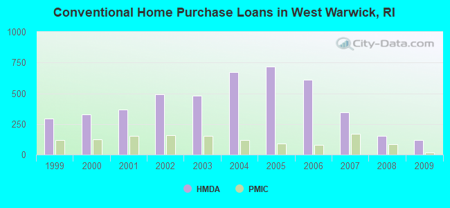
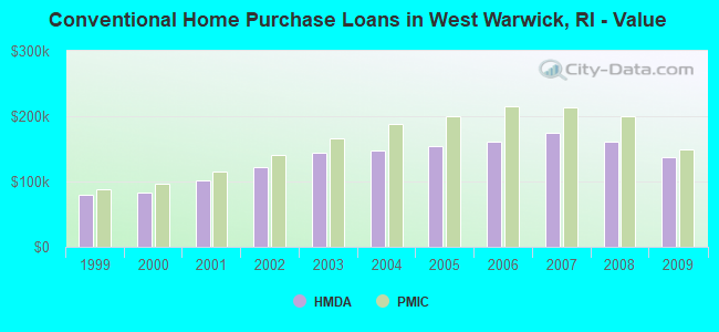
| Home Mortgage Disclosure Act Aggregated Statistics For Year 2009 (Based on 6 full tracts) | ||||||||||||||
| A) FHA, FSA/RHS & VA Home Purchase Loans | B) Conventional Home Purchase Loans | C) Refinancings | D) Home Improvement Loans | E) Loans on Dwellings For 5+ Families | F) Non-occupant Loans on < 5 Family Dwellings (A B C & D) | G) Loans On Manufactured Home Dwelling (A B C & D) | ||||||||
|---|---|---|---|---|---|---|---|---|---|---|---|---|---|---|
| Number | Average Value | Number | Average Value | Number | Average Value | Number | Average Value | Number | Average Value | Number | Average Value | Number | Average Value | |
| LOANS ORIGINATED | 134 | $164,187 | 116 | $137,448 | 532 | $154,705 | 54 | $79,704 | 5 | $1,423,600 | 42 | $133,500 | 0 | $0 |
| APPLICATIONS APPROVED, NOT ACCEPTED | 9 | $162,889 | 7 | $116,571 | 47 | $177,830 | 8 | $61,500 | 0 | $0 | 2 | $155,500 | 0 | $0 |
| APPLICATIONS DENIED | 24 | $166,792 | 27 | $122,593 | 192 | $180,328 | 18 | $56,389 | 2 | $267,500 | 19 | $113,842 | 1 | $116,000 |
| APPLICATIONS WITHDRAWN | 16 | $155,438 | 16 | $125,438 | 122 | $184,639 | 5 | $37,000 | 0 | $0 | 8 | $126,625 | 0 | $0 |
| FILES CLOSED FOR INCOMPLETENESS | 8 | $152,375 | 2 | $56,500 | 37 | $192,000 | 1 | $120,000 | 0 | $0 | 3 | $156,333 | 0 | $0 |
Detailed HMDA statistics for the following Tracts: 0201.01 , 0201.02, 0202.00, 0203.00, 0204.00, 0205.00
| Private Mortgage Insurance Companies Aggregated Statistics For Year 2009 (Based on 6 full tracts) | ||||||
| A) Conventional Home Purchase Loans | B) Refinancings | C) Non-occupant Loans on < 5 Family Dwellings (A & B) | ||||
|---|---|---|---|---|---|---|
| Number | Average Value | Number | Average Value | Number | Average Value | |
| LOANS ORIGINATED | 16 | $149,250 | 9 | $201,556 | 0 | $0 |
| APPLICATIONS APPROVED, NOT ACCEPTED | 9 | $204,889 | 5 | $200,200 | 1 | $212,000 |
| APPLICATIONS DENIED | 11 | $136,818 | 2 | $141,500 | 0 | $0 |
| APPLICATIONS WITHDRAWN | 7 | $187,429 | 0 | $0 | 0 | $0 |
| FILES CLOSED FOR INCOMPLETENESS | 0 | $0 | 0 | $0 | 0 | $0 |
Detailed PMIC statistics for the following Tracts: 0201.01 , 0201.02, 0202.00, 0203.00, 0204.00, 0205.00
2009 - 2018 National Fire Incident Reporting System (NFIRS) incidents
- Fire incident types reported to NFIRS in West Warwick, RI
- 68668.6%Structure Fires
- 25425.4%Outside Fires
- 454.5%Mobile Property/Vehicle Fires
- 151.5%Other
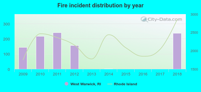 Based on the data from the years 2009 - 2018 the average number of fire incidents per year is 100. The highest number of fire incidents - 242 took place in 2011, and the least - 0 in 2015. The data has an increasing trend.
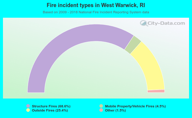 When looking into fire subcategories, the most reports belonged to: Structure Fires (68.6%), and Outside Fires (25.4%).
Fire-safe hotels and motels in West Warwick, Rhode Island:
- Extended Stay America - Providence - West Warwick, 1235 Division Rd, West Warwick, Rhode Island 02893 , Phone: (401) 885-3161, Fax: (401) 885-3162
- Comfort Suites, 10 Keyes Way, West Warwick, Rhode Island 02893 , Phone: (401) 826-1800, Fax: (401) 826-4170
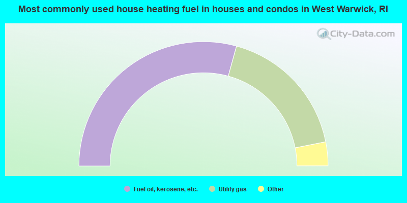
- 58.5%Fuel oil, kerosene, etc.
- 35.2%Utility gas
- 3.7%Electricity
- 1.7%Bottled, tank, or LP gas
- 0.3%Wood
- 0.2%Coal or coke
- 0.2%Other fuel
- 0.1%No fuel used
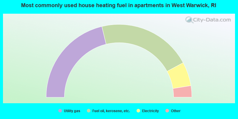
- 42.4%Utility gas
- 41.8%Fuel oil, kerosene, etc.
- 10.6%Electricity
- 3.6%Bottled, tank, or LP gas
- 0.8%Other fuel
- 0.7%No fuel used
West Warwick compared to Rhode Island state average:
- Unemployed percentage below state average.
- Black race population percentage significantly below state average.
- Hispanic race population percentage significantly below state average.
- Median age below state average.
- Foreign-born population percentage below state average.
- Renting percentage significantly below state average.
- Length of stay since moving in significantly above state average.
- Number of rooms per house significantly below state average.
- House age significantly below state average.
- Institutionalized population percentage significantly above state average.
- Percentage of population with a bachelor's degree or higher below state average.
West Warwick on our top lists:
- #23 on the list of "Top 101 cities with largest percentage of males in industries: miscellaneous manufacturing (population 5,000+)"
- #33 on the list of "Top 101 cities with largest percentage of females in industries: miscellaneous manufacturing (population 5,000+)"
- #34 on the list of "Top 101 cities with largest percentage of females in industries: pharmacies and drug stores (population 5,000+)"
- #39 on the list of "Top 101 cities with largest percentage of males in occupations: material recording, scheduling, dispatching, and distributing workers (population 5,000+)"
- #52 on the list of "Top 101 cities with largest percentage of males in industries: retail florists (population 5,000+)"
- #76 on the list of "Top 101 cities with largest percentage of females in occupations: metal workers and plastic workers (population 5,000+)"
- #76 on the list of "Top 101 cities with largest percentage of males in industries: pharmacies and drug stores (population 5,000+)"
- #77 on the list of "Top 101 cities with largest percentage of females in occupations: customer service representatives (population 5,000+)"
- #79 on the list of "Top 101 cities with largest percentage of males in occupations: cooks and food preparation workers (population 5,000+)"
- #89 on the list of "Top 101 cities with largest percentage of females in industries: jewelry, luggage, and leather goods stores (population 5,000+)"
- #90 on the list of "Top 101 cities with largest percentage of females in industries: alcoholic beverages merchant wholesalers (population 5,000+)"
- #90 on the list of "Top 101 cities with largest percentage of females in industries: electrical equipment, appliances, and components (population 5,000+)"
- #92 on the list of "Top 101 cities with largest percentage of males in occupations: therapists (population 5,000+)"
- #99 on the list of "Top 101 cities with largest percentage of males in industries: textile mills and textile products (population 5,000+)"
- #101 on the list of "Top 101 cities with largest percentage of females in occupations: vehicle and mobile equipment mechanics, installers, and repairers (population 5,000+)"
- #76 (02893) on the list of "Top 101 zip codes with the largest percentage of Portuguese first ancestries (pop 5,000+)"
- #3 on the list of "Top 101 counties with the lowest Nitrogen Dioxide air pollution readings in 2012 (ppm)"
- #8 on the list of "Top 101 counties with the lowest Particulate Matter (PM10) Annual air pollution readings in 2012 (µg/m3)"
- #14 on the list of "Top 101 counties with the lowest percentage of residents relocating from foreign countries between 2010 and 2011"
- #17 on the list of "Top 101 counties with the lowest total withdrawal of fresh water for public supply (pop. 50,000+)"
- #30 on the list of "Top 101 counties with the highest percentage of residents that smoked 100+ cigarettes in their lives"

|
|
Total of 126 patent applications in 2008-2024.