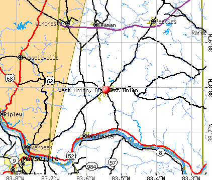
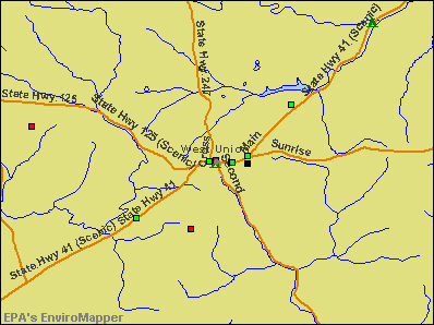
West Union, Ohio

West Union: Courthouse

West Union: woods

West Union: Wufd ladder 18
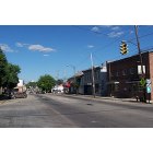
West Union: downtown
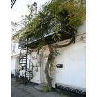
West Union: Building
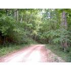
West Union: country road
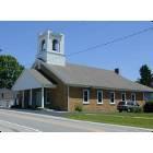
West Union: First Presybterian Church
- add
your
Submit your own pictures of this village and show them to the world
- OSM Map
- General Map
- Google Map
- MSN Map
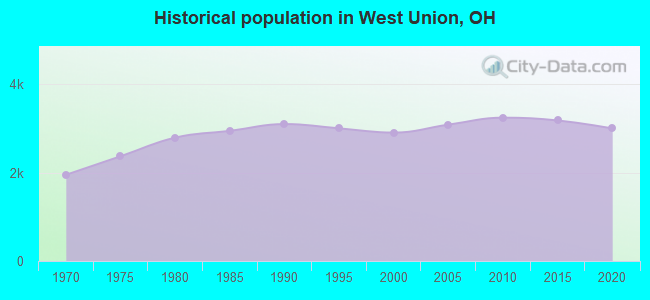
Population change since 2000: +3.4%
 |
| Males: 1,528 | |
| Females: 1,474 |
| Median resident age: | 44.5 years |
| Ohio median age: | 39.9 years |
Zip codes: 45693.
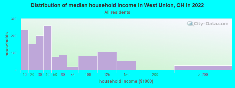
| West Union: | $32,694 |
| OH: | $65,720 |
Estimated per capita income in 2022: $21,446 (it was $13,301 in 2000)
West Union village income, earnings, and wages data
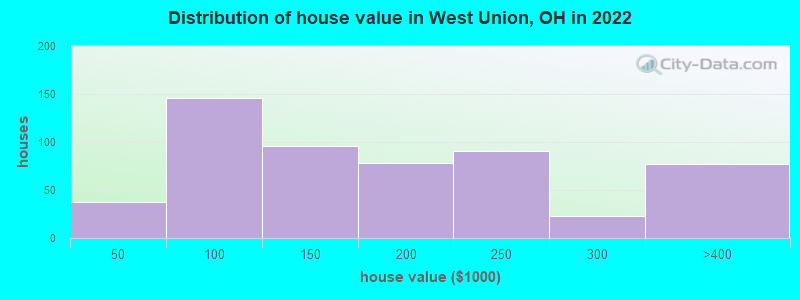
Estimated median house or condo value in 2022: $133,060 (it was $57,800 in 2000)
| West Union: | $133,060 |
| OH: | $204,100 |
Mean prices in 2022: all housing units: $150,419; detached houses: $159,759; mobile homes: $47,676
Median gross rent in 2022: $548.
(27.8% for White Non-Hispanic residents, 7.1% for Black residents, 36.5% for two or more races residents)
Detailed information about poverty and poor residents in West Union, OH
Compare current foreclosures near West Union, OH:
| Photo | Address | Area | Beds / Baths | Price | Details |
|---|---|---|---|---|---|

|
#1
State Route 125
West Union, OH 45693
|
1,123 sq. feet
|
1 baths 3 beds |
show details | |

|
#2
Ballard St
West Union, OH 45693
|
960 sq. feet
|
1 baths 3 beds |
show details | |

|
#3
Mark Dr
West Union, OH 45693
|
1,352 sq. feet
|
1 baths 3 beds |
show details | |

|
#4
Alex Ln
West Union, OH 45693
|
1,120 sq. feet
|
2 baths 2 beds |
show details | |

|
#5
S Market St
West Union, OH 45693
|
1,335 sq. feet
|
1 baths 3 beds |
show details | |

|
#6
Kennedy Ave
West Union, OH 45693
|
1,536 sq. feet
|
2 baths 3 beds |
show details | |

|
#7
Gatewood Dr
West Union, OH 45693
|
1,402 sq. feet
|
2 baths 3 beds |
show details | |

|
#8
1st St
West Union, OH 45693
|
1,001 sq. feet
|
1 baths 3 beds |
show details | |

|
#9
Lovejoy Rd Apt A
West Union, OH 45693
|
- sq. feet
|
- baths - beds |
show details | |

|
#10
Chapparal Rd
West Union, OH 45693
|
- sq. feet
|
- baths - beds |
show details |
| Photo | Address | Area | Beds / Baths | Price | Details |
|---|---|---|---|---|---|

|
#11
State Route 125
West Union, OH 45693
|
- sq. feet
|
- baths - beds |
show details | |

|
#12
E 7th St
Manchester, OH 45144
|
1,000 sq. feet
|
1 baths 2 beds |
show details | |

|
#13
Valley Vista Dr
Manchester, OH 45144
|
1,546 sq. feet
|
2 baths 3 beds |
show details | |

|
#14
Tricounty Hwy
Sardinia, OH 45171
|
1,620 sq. feet
|
3 baths 3 beds |
show details | |

|
#15
Bridge St
Maysville, KY 41056
|
1,870 sq. feet
|
1 baths 3 beds |
show details | |

|
#16
Ash St
Maysville, KY 41056
|
832 sq. feet
|
1 baths 2 beds |
show details | |

|
#17
Barbour Dr
Aberdeen, OH 45101
|
1,428 sq. feet
|
2 baths 2 beds |
show details | |

|
#18
Broadway St
Maysville, KY 41056
|
1,470 sq. feet
|
1 baths 3 beds |
show details | |

|
#19
Mason Lewis Rd
Maysville, KY 41056
|
1,426 sq. feet
|
1 baths 3 beds |
show details | |

|
#20
Florence St
Maysville, KY 41056
|
870 sq. feet
|
1 baths 2 beds |
show details |
| Photo | Address | Area | Beds / Baths | Price | Details |
|---|---|---|---|---|---|

|
#21
State Route 125
Georgetown, OH 45121
|
1,345 sq. feet
|
2 baths 3 beds |
show details | |

|
#22
Commerce St
Maysville, KY 41056
|
1,040 sq. feet
|
1 baths 2 beds |
show details | |

|
#23
Mason Lewis Rd
Maysville, KY 41056
|
1,848 sq. feet
|
1 baths 3 beds |
show details | |

|
#24
Ripley Rd
Ripley, OH 45167
|
2,448 sq. feet
|
1 baths 3 beds |
show details | |

|
#25
Mason Lewis Rd
Maysville, KY 41056
|
1,500 sq. feet
|
2 baths 4 beds |
show details | |

|
#26
Waynoka Dr
Sardinia, OH 45171
|
1,152 sq. feet
|
2 baths 3 beds |
show details | |

|
#27
Lexington Pike
Maysville, KY 41056
|
2,388 sq. feet
|
2 baths 4 beds |
show details | |

|
#28
Jersey Ridge Rd
Maysville, KY 41056
|
10,000 sq. feet
|
1 baths 2 beds |
show details | |

|
#29
Elk River Rd
Ripley, OH 45167
|
960 sq. feet
|
1 baths 2 beds |
show details | |

|
#30
Orangeburg Rd
Maysville, KY 41056
|
1,328 sq. feet
|
2 baths 2 beds |
show details |
| Photo | Address | Area | Beds / Baths | Price | Details |
|---|---|---|---|---|---|

|
#31
Frog Hollow Rd
Peebles, OH 45660
|
1,568 sq. feet
|
2 baths 3 beds |
show details | |

|
#32
Kevin Dr
Ripley, OH 45167
|
1,440 sq. feet
|
2 baths 3 beds |
show details | |

|
#33
Flora Ave
Ripley, OH 45167
|
1,080 sq. feet
|
2 baths 3 beds |
show details | |

|
#34
Ash St
Maysville, KY 41056
|
1,320 sq. feet
|
1 baths 2 beds |
show details | |

|
#35
Ripley Day Hill Rd
Ripley, OH 45167
|
2,020 sq. feet
|
1 baths 4 beds |
show details | |

|
#36
Hinton Dr
Maysville, KY 41056
|
1,640 sq. feet
|
2 baths 3 beds |
show details | |

|
#37
Hinton Dr
Maysville, KY 41056
|
1,456 sq. feet
|
1 baths 3 beds |
show details | |

|
#38
Walnut Ln
Maysville, KY 41056
|
2,016 sq. feet
|
2 baths 4 beds |
show details | |

|
#39
Waynoka Dr
Sardinia, OH 45171
|
1,872 sq. feet
|
4 baths 3 beds |
show details | |

|
#40
Ashridge Arnheim Rd
Sardinia, OH 45171
|
1,008 sq. feet
|
2 baths 3 beds |
show details |
| Photo | Address | Area | Beds / Baths | Price | Details |
|---|---|---|---|---|---|

|
#41
Mary Ingles Hwy
Dover, KY 41034
|
1,764 sq. feet
|
1 baths 3 beds |
show details | |

|
#42
Shawnee Rd
Otway, OH 45657
|
1,556 sq. feet
|
1 baths 3 beds |
show details | |

|
#43
Eckmansville Rd
Winchester, OH 45697
|
1,025 sq. feet
|
1 baths 3 beds |
show details | |

|
#44
Rhodes Rd
Lynx, OH 45650
|
1,332 sq. feet
|
2 baths 3 beds |
show details | |

|
#45
Cemetery St
Manchester, OH 45144
|
1,456 sq. feet
|
2 baths 3 beds |
show details | |

|
#46
State Route 247
Seaman, OH 45679
|
1,580 sq. feet
|
1 baths 3 beds |
show details | |

|
#47
N Pole Rd
Ripley, OH 45167
|
1,008 sq. feet
|
1 baths 3 beds |
show details | |

|
#48
Steam Furnace Rd
Peebles, OH 45660
|
813 sq. feet
|
1 baths 2 beds |
show details | |

|
#49
Steam Furnace Rd
Peebles, OH 45660
|
896 sq. feet
|
1 baths 2 beds |
show details | |

|
Check over 1 million property listings on Foreclosure.com!
|
browse all offers | |||


- 2,82894.6%White alone
- 652.2%Two or more races
- 521.7%Hispanic
- 150.5%Black alone
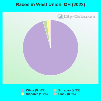
Races in West Union detailed stats: ancestries, foreign born residents, place of birth
According to our research of Ohio and other state lists, there were 29 registered sex offenders living in West Union, Ohio as of April 26, 2024.
The ratio of all residents to sex offenders in West Union is 105 to 1.
Type |
2009 |
2010 |
2011 |
2013 |
2014 |
2015 |
2016 |
2017 |
2018 |
2019 |
2020 |
2021 |
2022 |
|---|---|---|---|---|---|---|---|---|---|---|---|---|---|
| Murders (per 100,000) | 0 (0.0) | 1 (30.9) | 0 (0.0) | 0 (0.0) | 0 (0.0) | 0 (0.0) | 0 (0.0) | 0 (0.0) | 0 (0.0) | 0 (0.0) | 0 (0.0) | 0 (0.0) | 0 (0.0) |
| Rapes (per 100,000) | 0 (0.0) | 0 (0.0) | 0 (0.0) | 0 (0.0) | 2 (62.7) | 3 (94.2) | 0 (0.0) | 0 (0.0) | 1 (31.8) | 0 (0.0) | 1 (31.7) | 1 (31.9) | 0 (0.0) |
| Robberies (per 100,000) | 0 (0.0) | 0 (0.0) | 0 (0.0) | 0 (0.0) | 1 (31.4) | 0 (0.0) | 0 (0.0) | 0 (0.0) | 0 (0.0) | 0 (0.0) | 0 (0.0) | 0 (0.0) | 0 (0.0) |
| Assaults (per 100,000) | 7 (225.7) | 2 (61.7) | 0 (0.0) | 2 (62.3) | 3 (94.1) | 1 (31.4) | 5 (157.9) | 6 (189.4) | 3 (95.5) | 3 (95.1) | 2 (63.5) | 0 (0.0) | 0 (0.0) |
| Burglaries (per 100,000) | 48 (1,547) | 53 (1,635) | 4 (123.3) | 4 (124.6) | 15 (470.5) | 12 (376.8) | 17 (536.8) | 1 (31.6) | 9 (286.5) | 7 (222.0) | 2 (63.5) | 2 (63.8) | 1 (33.1) |
| Thefts (per 100,000) | 116 (3,740) | 120 (3,703) | 6 (185.0) | 22 (685.1) | 47 (1,474) | 23 (722.1) | 23 (726.2) | 13 (410.4) | 4 (127.3) | 11 (348.9) | 10 (317.3) | 4 (127.5) | 2 (66.2) |
| Auto thefts (per 100,000) | 4 (128.9) | 2 (61.7) | 0 (0.0) | 2 (62.3) | 4 (125.5) | 4 (125.6) | 6 (189.5) | 5 (157.8) | 2 (63.7) | 3 (95.1) | 2 (63.5) | 0 (0.0) | 0 (0.0) |
| Arson (per 100,000) | 0 (0.0) | 0 (0.0) | 1 (30.8) | 0 (0.0) | 1 (31.4) | 1 (31.4) | 0 (0.0) | 0 (0.0) | 0 (0.0) | 0 (0.0) | 1 (31.7) | 0 (0.0) | 0 (0.0) |
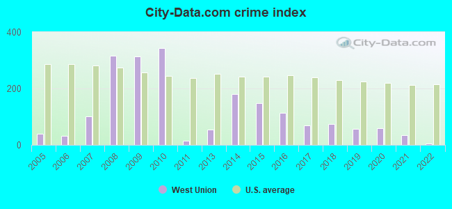
| City-Data.com crime index | 313.3 | 341.6 | 16.0 | 53.6 | 180.4 | 146.9 | 113.4 | 69.1 | 74.8 | 56.1 | 60.3 | 35.1 | 5.0 |
The City-Data.com crime index weighs serious crimes and violent crimes more heavily. Higher means more crime, U.S. average is 246.1. It adjusts for the number of visitors and daily workers commuting into cities.
Crime rate in West Union detailed stats: murders, rapes, robberies, assaults, burglaries, thefts, arson
Full-time law enforcement employees in 2021, including police officers: 4 (3 officers - 3 male; 0 female).
| Officers per 1,000 residents here: | 0.96 |
| Ohio average: | 2.31 |
 Recent articles from our blog. Our writers, many of them Ph.D. graduates or candidates, create easy-to-read articles on a wide variety of topics.

 | What part of Ohio would you prefer to vacation/visit? (14 replies) |
| Most Prominent Point in Ohio (20 replies) |
| Towns East of Cincinnati (17 replies) |
| Looking for Amish/Mennonite Carpentry Crews around Cinci....anyone know of any?.... (3 replies) |
| Does Ohio have traditionally southern cultural elements? (45 replies) |
| Day trips from cincinnati/Northern Ky area (32 replies) |
Latest news from West Union, OH collected exclusively by city-data.com from local newspapers, TV, and radio stations
Ancestries: American (27.5%), English (13.5%), German (8.0%), Scotch-Irish (4.6%), Irish (3.4%).
Current Local Time: EST time zone
Elevation: 967 feet
Land area: 2.57 square miles.
Population density: 1,169 people per square mile (low).
3 residents are foreign born
| This village: | 0.1% |
| Ohio: | 4.9% |
Median real estate property taxes paid for housing units with mortgages in 2022: $1,351 (0.8%)
Median real estate property taxes paid for housing units with no mortgage in 2022: $1,155 (1.0%)
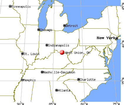
Nearest city with pop. 50,000+: Cincinnati, OH  (56.8 miles , pop. 331,285).
Nearest city with pop. 1,000,000+: Chicago, IL (303.2 miles , pop. 2,896,016).
Nearest cities:
), ), ), Latitude: 38.79 N, Longitude: 83.54 W
Area code: 937
West Union, Ohio accommodation & food services, waste management - Economy and Business Data
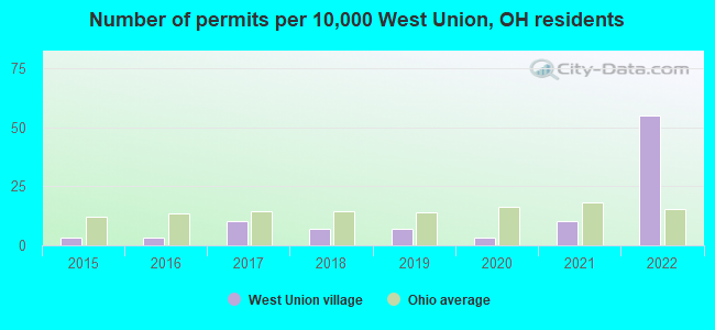
Single-family new house construction building permits:
- 2022: 16 buildings, average cost: $273,300
- 2021: 3 buildings, average cost: $244,800
- 2020: 1 building, cost: $237,700
- 2019: 2 buildings, average cost: $75,000
- 2018: 2 buildings, average cost: $214,500
- 2017: 3 buildings, average cost: $133,300
- 2016: 1 building, cost: $201,500
- 2015: 1 building, cost: $201,500

| Here: | 4.9% |
| Ohio: | 3.1% |
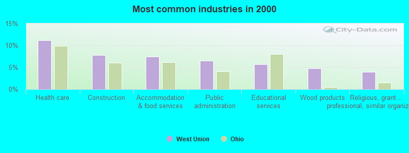
- Health care (11.1%)
- Construction (7.8%)
- Accommodation & food services (7.4%)
- Public administration (6.5%)
- Educational services (5.7%)
- Wood products (4.8%)
- Religious, grantmaking, civic, professional, similar organizations (3.9%)
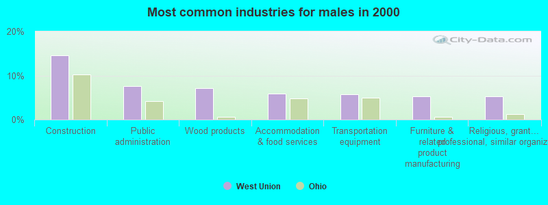
- Construction (14.6%)
- Public administration (7.6%)
- Wood products (7.2%)
- Accommodation & food services (5.9%)
- Transportation equipment (5.7%)
- Furniture & related product manufacturing (5.3%)
- Religious, grantmaking, civic, professional, similar organizations (5.3%)
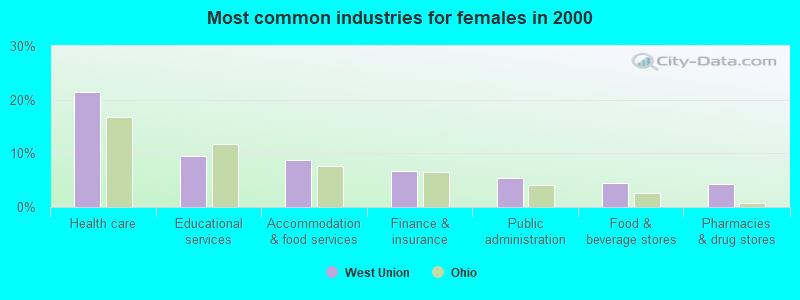
- Health care (21.4%)
- Educational services (9.5%)
- Accommodation & food services (8.7%)
- Finance & insurance (6.8%)
- Public administration (5.4%)
- Food & beverage stores (4.5%)
- Pharmacies & drug stores (4.3%)
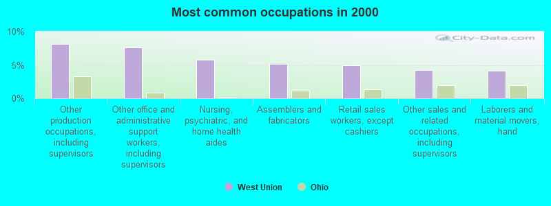
- Other production occupations, including supervisors (8.1%)
- Other office and administrative support workers, including supervisors (7.6%)
- Nursing, psychiatric, and home health aides (5.8%)
- Assemblers and fabricators (5.2%)
- Retail sales workers, except cashiers (5.0%)
- Other sales and related occupations, including supervisors (4.3%)
- Laborers and material movers, hand (4.1%)
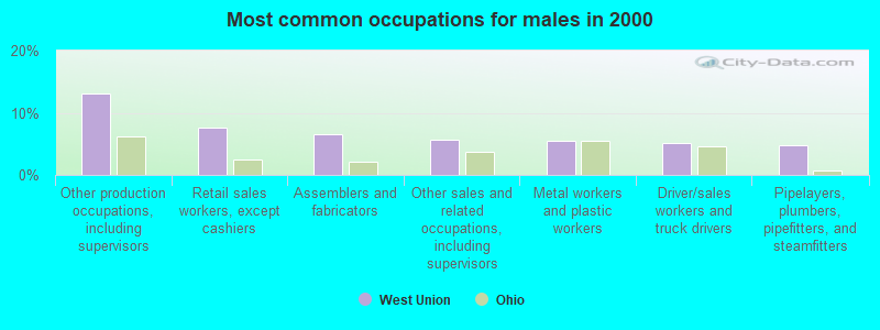
- Other production occupations, including supervisors (13.1%)
- Retail sales workers, except cashiers (7.6%)
- Assemblers and fabricators (6.6%)
- Other sales and related occupations, including supervisors (5.7%)
- Metal workers and plastic workers (5.5%)
- Driver/sales workers and truck drivers (5.1%)
- Pipelayers, plumbers, pipefitters, and steamfitters (4.9%)
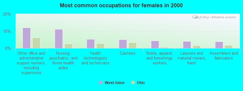
- Other office and administrative support workers, including supervisors (12.0%)
- Nursing, psychiatric, and home health aides (11.1%)
- Health technologists and technicians (5.2%)
- Cashiers (5.0%)
- Textile, apparel, and furnishings workers (4.5%)
- Laborers and material movers, hand (4.1%)
- Assemblers and fabricators (3.9%)
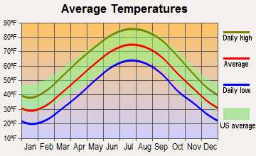
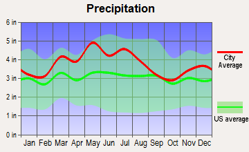
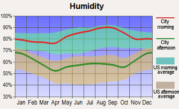
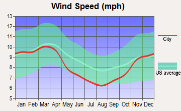
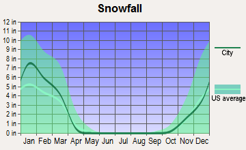
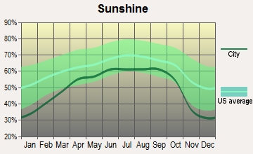
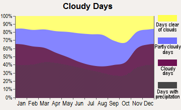
Average climate in West Union, Ohio
Based on data reported by over 4,000 weather stations
|
|

(lower is better)
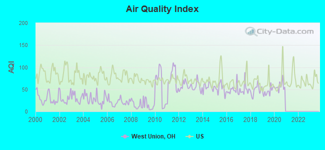
Air Quality Index (AQI) level in 2020 was 57.1. This is better than average.
| City: | 57.1 |
| U.S.: | 72.6 |
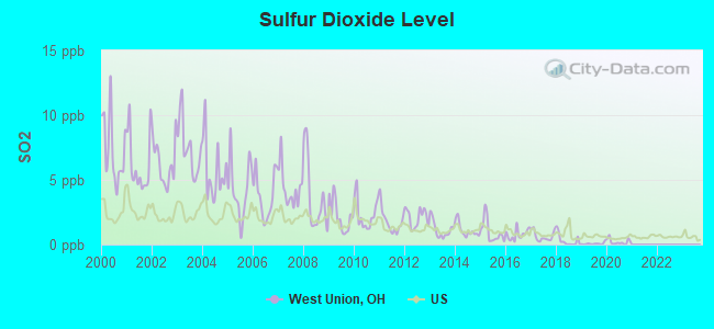
Sulfur Dioxide (SO2) [ppb] level in 2020 was 0.213. This is significantly better than average. Closest monitor was 0.5 miles away from the city center.
| City: | 0.213 |
| U.S.: | 1.515 |
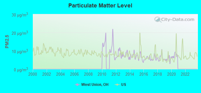
Particulate Matter (PM2.5) [µg/m3] level in 2020 was 7.41. This is about average. There were 0 monitors within city limits.
| City: | 7.41 |
| U.S.: | 8.11 |
Tornado activity:
West Union-area historical tornado activity is slightly below Ohio state average. It is 3% greater than the overall U.S. average.
On 4/23/1968, a category F5 (max. wind speeds 261-318 mph) tornado 40.6 miles away from the West Union village center killed 7 people and injured 93 people and caused between $500,000 and $5,000,000 in damages.
On 4/3/1974, a category F3 (max. wind speeds 158-206 mph) tornado 3.5 miles away from the village center killed one person and caused between $500 and $5000 in damages.
Earthquake activity:
West Union-area historical earthquake activity is significantly above Ohio state average. It is 29% greater than the overall U.S. average.On 7/27/1980 at 18:52:21, a magnitude 5.2 (5.1 MB, 4.7 MS, 5.0 UK, 5.2 UK, Class: Moderate, Intensity: VI - VII) earthquake occurred 46.1 miles away from the city center
On 9/7/1988 at 02:28:09, a magnitude 4.6 (4.5 MB, 4.6 LG, Class: Light, Intensity: IV - V) earthquake occurred 48.5 miles away from West Union center
On 8/23/2011 at 17:51:04, a magnitude 5.8 (5.8 MW, Depth: 3.7 mi) earthquake occurred 310.2 miles away from the city center
On 4/18/2008 at 09:36:59, a magnitude 5.4 (5.1 MB, 4.8 MS, 5.4 MW, 5.2 MW) earthquake occurred 235.8 miles away from the city center
On 8/9/2020 at 12:07:37, a magnitude 5.1 (5.1 MW, Depth: 4.7 mi) earthquake occurred 209.1 miles away from the city center
On 4/18/2008 at 09:36:59, a magnitude 5.2 (5.2 MW, Depth: 8.9 mi) earthquake occurred 235.8 miles away from the city center
Magnitude types: regional Lg-wave magnitude (LG), body-wave magnitude (MB), surface-wave magnitude (MS), moment magnitude (MW)
Natural disasters:
The number of natural disasters in Adams County (16) is near the US average (15).Major Disasters (Presidential) Declared: 11
Emergencies Declared: 2
Causes of natural disasters: Floods: 9, Storms: 8, Landslides: 2, Mudslides: 2, Tornadoes: 2, Winds: 2, Winter Storms: 2, Blizzard: 1, Heavy Rain: 1, Hurricane: 1, Snowstorm: 1, Other: 1 (Note: some incidents may be assigned to more than one category).
Hospitals and medical centers in West Union:
- ADAMS COUNTY HOSPITAL (provides emergency services, 210 NORTH WILSON DRIVE)
- ADAMS COUNTY HOSPITAL CARE CENTER (210 NORTH WILSON DRIVE)
- ADAMS COUNTY MANOR (10856 STATE ROUTE 41)
- CHESTNUT RIDGE CARE CENTER (100 CHESTNUT RIDGE RD)
- EAGLE CREEK NURSING CENTER (141 SPRUCE LANE)
- REVMONT NURSING HOME (7980 ST RT 125)
Airports located in West Union:
- Alexander Salamon Airport (AMT) (Runways: 1, Air Taxi Ops: 200, Itinerant Ops: 2,000, Local Ops: 3,000, Military Ops: 10)
Colleges/universities with over 2000 students nearest to West Union:
- Maysville Community and Technical College (about 19 miles; Maysville, KY; Full-time enrollment: 2,969)
- Shawnee State University (about 30 miles; Portsmouth, OH; FT enrollment: 4,160)
- Southern State Community College (about 31 miles; Hillsboro, OH; FT enrollment: 2,418)
- University of Cincinnati-Clermont College (about 41 miles; Batavia, OH; FT enrollment: 2,739)
- Morehead State University (about 43 miles; Morehead, KY; FT enrollment: 7,523)
- Northern Kentucky University (about 53 miles; Highland Heights, KY; FT enrollment: 12,059)
- Ashland Community and Technical College (about 54 miles; Ashland, KY; FT enrollment: 2,482)
Public high schools in West Union:
- WEST UNION HIGH SCHOOL (Students: 572, Location: 97 DRAGON LAIR DR, Grades: 7-12)
- OHIO VALLEY CAREER & TECHNICAL CENTER (Location: 175 LLOYD RD, Grades: 11-12)
Private high school in West Union:
Public elementary/middle school in West Union:
- WEST UNION ELEMENTARY SCHOOL (Students: 850, Location: 555 LLOYD RD, Grades: PK-6)
Points of interest:
Notable locations in West Union: West Union Volunteer Life Squad (A), West Union Volunteer Fire Department Station 18 (B). Display/hide their locations on the map
Churches in West Union include: West Union United Methodist Church (A), West Union Church of the Nazarene (B), First Baptist Church (C), West Union Presbyterian Church (D). Display/hide their locations on the map
Cemeteries: Pumpkin Ridge Cemetery (1), Independent Order of Oddfellows Cemetery (2), Lovejoy Cemetery (3). Display/hide their locations on the map
Tourist attractions: Cincinnati Museum of Natural History (3223 Waggoner Riffle Road), Adams County Historical Society (Museums; 507 North Cherry Street).
Hotels: Four Seasons Tanning (809 Boyd Avenue), Country Nights Inn (11255 State Rte 41).
Court: Adams County - Common Pleas Judge- Juvenile Court- Probate Court (Courthouse).
Birthplace of: Damien Burroughs - Australian Paralympic athlete.
Drinking water stations with addresses in West Union and their reported violations in the past:
ADAMS COUNTY REGIONAL WD PWS (Address: 9203 St Rt 136 , Population served: 19,194, Groundwater):Past monitoring violations:
- One routine major monitoring violation
- One minor monitoring violation
| This village: | 2.3 people |
| Ohio: | 2.4 people |
| This village: | 60.9% |
| Whole state: | 65.0% |
| This village: | 9.0% |
| Whole state: | 6.8% |
Likely homosexual households (counted as self-reported same-sex unmarried-partner households)
- Lesbian couples: 0.3% of all households
- Gay men: 0.2% of all households
People in group quarters in West Union in 2010:
- 152 people in nursing facilities/skilled-nursing facilities
- 51 people in local jails and other municipal confinement facilities
- 8 people in group homes intended for adults
People in group quarters in West Union in 2000:
- 145 people in nursing homes
- 23 people in other group homes
- 8 people in local jails and other confinement facilities (including police lockups)
Banks with branches in West Union (2011 data):
- Fifth Third Bank: West Union Branch at 500 East Main Street, branch established on 1909/03/07. Info updated 2009/10/05: Bank assets: $114,540.4 mil, Deposits: $89,689.1 mil, headquarters in Cincinnati, OH, positive income, Commercial Lending Specialization, 1378 total offices, Holding Company: Fifth Third Bancorp
- Woodforest National Bank: West Union Wal-Mart Branch at 11217 State Route 41, branch established on 2006/08/09. Info updated 2011/05/10: Bank assets: $3,488.9 mil, Deposits: $3,097.6 mil, headquarters in Houston, TX, positive income, Commercial Lending Specialization, 766 total offices, Holding Company: Woodforest Financial Group Employee Stock Ownership Plan (With 401(K) Provisions)
- Adams County Building and Loan Company: Adams County Building And Loan Compa at 201 West Main Street, branch established on 1907/01/22. Info updated 2012/01/04: Bank assets: $26.1 mil, Deposits: $22.1 mil, local headquarters, positive income, 2 total offices
- The National Bank of Adams County of West Union: The National Bank Of Adams County Of at 28 North Market, branch established on 1928/04/28. Info updated 2006/11/03: Bank assets: $78.7 mil, Deposits: $68.9 mil, local headquarters, positive income, 1 total offices
- First State Bank: West Union Branch at 409 West Main Street, branch established on 1989/07/24. Info updated 2012/01/04: Bank assets: $234.3 mil, Deposits: $207.8 mil, headquarters in Winchester, OH, positive income, 8 total offices, Holding Company: First State Bancorp, Inc.
For population 15 years and over in West Union:
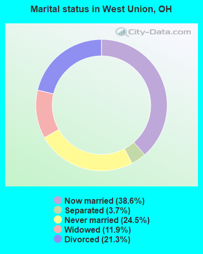
- Never married: 24.5%
- Now married: 38.6%
- Separated: 3.7%
- Widowed: 11.9%
- Divorced: 21.3%
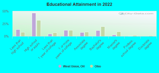
For population 25 years and over in West Union:
- High school or higher: 85.7%
- Bachelor's degree or higher: 14.5%
- Graduate or professional degree: 3.3%
- Unemployed: 7.9%
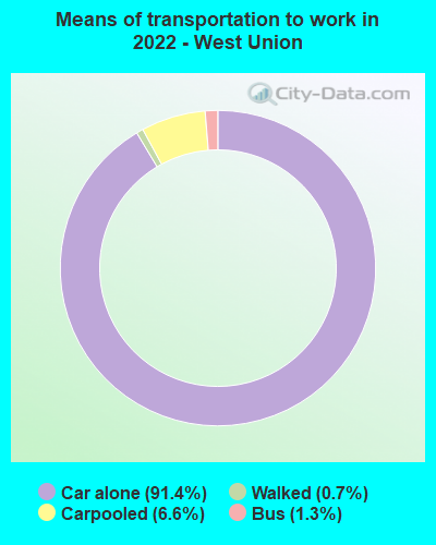
- Mean travel time to work (commute): 23.2 minutes
| Here: | 9.4 |
| Ohio average: | 11.0 |

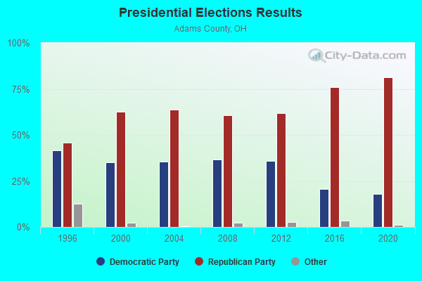
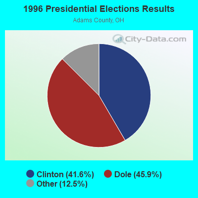
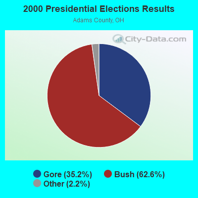
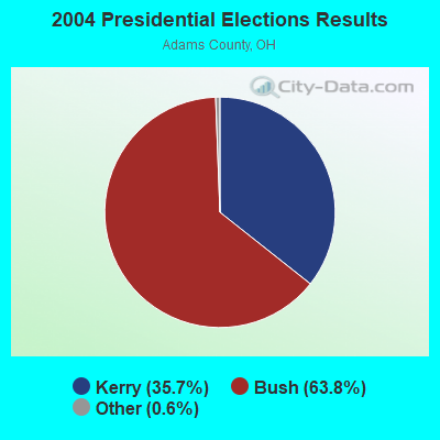
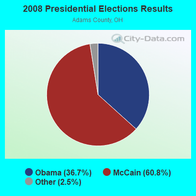
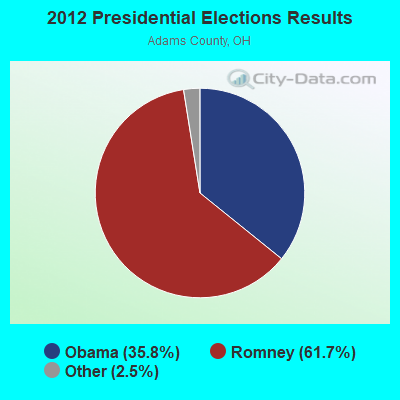
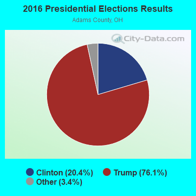
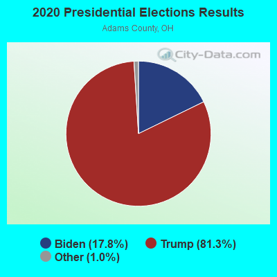
Graphs represent county-level data. Detailed 2008 Election Results
Religion statistics for West Union, OH (based on Adams County data)
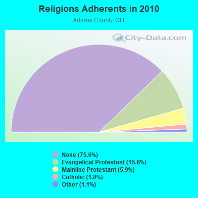
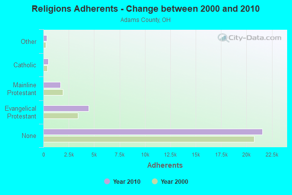
| Religion | Adherents | Congregations |
|---|---|---|
| Evangelical Protestant | 4,464 | 56 |
| Mainline Protestant | 1,679 | 25 |
| Catholic | 500 | 2 |
| Other | 322 | 1 |
| None | 21,585 | - |
Food Environment Statistics:
| Adams County: | 1.78 / 10,000 pop. |
| Ohio: | 1.89 / 10,000 pop. |
| Adams County: | 0.36 / 10,000 pop. |
| Ohio: | 0.13 / 10,000 pop. |
| Here: | 0.71 / 10,000 pop. |
| Ohio: | 1.25 / 10,000 pop. |
| Here: | 4.27 / 10,000 pop. |
| State: | 2.93 / 10,000 pop. |
| Adams County: | 5.69 / 10,000 pop. |
| Ohio: | 6.25 / 10,000 pop. |
| Adams County: | 10.8% |
| State: | 10.3% |
| This county: | 29.3% |
| Ohio: | 29.1% |
| Adams County: | 13.5% |
| Ohio: | 11.9% |
Health and Nutrition:
| West Union: | 63.4% |
| Ohio: | 50.4% |
| West Union: | 67.5% |
| Ohio: | 47.8% |
| This city: | 26.8 |
| Ohio: | 28.7 |
| West Union: | 18.2% |
| Ohio: | 20.6% |
| Here: | 8.4% |
| Ohio: | 10.4% |
| Here: | 7.4 |
| Ohio: | 6.8 |
| This city: | 34.7% |
| State: | 34.3% |
| Here: | 68.8% |
| Ohio: | 57.0% |
| West Union: | 84.1% |
| Ohio: | 79.1% |
More about Health and Nutrition of West Union, OH Residents
| Local government employment and payroll (March 2022) | |||||
| Function | Full-time employees | Monthly full-time payroll | Average yearly full-time wage | Part-time employees | Monthly part-time payroll |
|---|---|---|---|---|---|
| Police Protection - Officers | 6 | $17,526 | $35,052 | 0 | $0 |
| Sewerage | 4 | $12,176 | $36,528 | 0 | $0 |
| Water Supply | 2 | $7,179 | $43,074 | 1 | $1,486 |
| Judicial and Legal | 1 | $5,859 | $70,308 | 2 | $7,064 |
| Streets and Highways | 1 | $3,656 | $43,872 | 1 | $2,245 |
| Other and Unallocable | 1 | $5,830 | $69,960 | 1 | $2,228 |
| Other Government Administration | 0 | $0 | 11 | $15,053 | |
| Financial Administration | 0 | $0 | 1 | $4,743 | |
| Totals for Government | 15 | $52,226 | $41,781 | 17 | $32,818 |
West Union government finances - Expenditure in 2017 (per resident):
- Construction - Regular Highways: $168,000 ($55.96)
Sewerage: $29,000 ($9.66)
- Current Operations - Water Utilities: $555,000 ($184.88)
Sewerage: $335,000 ($111.59)
Police Protection: $227,000 ($75.62)
General - Other: $197,000 ($65.62)
Local Fire Protection: $179,000 ($59.63)
Regular Highways: $139,000 ($46.30)
Central Staff Services: $130,000 ($43.30)
General Public Buildings: $82,000 ($27.32)
Judicial and Legal Services: $70,000 ($23.32)
Health - Other: $45,000 ($14.99)
Financial Administration: $31,000 ($10.33)
Miscellaneous Commercial Activities - Other: $5,000 ($1.67)
- Intergovernmental to Local - Other - Water Utilities: $45,000 ($14.99)
Other - Health - Other: $7,000 ($2.33)
- Other Capital Outlay - Police Protection: $69,000 ($22.98)
Water Utilities: $25,000 ($8.33)
Sewerage: $25,000 ($8.33)
- Total Salaries and Wages: $632,000 ($210.53)
- Water Utilities - Interest on Debt: $124,000 ($41.31)
West Union government finances - Revenue in 2017 (per resident):
- Charges - Sewerage: $694,000 ($231.18)
- Local Intergovernmental - Health and Hospitals: $79,000 ($26.32)
General Local Government Support: $12,000 ($4.00)
- Miscellaneous - Fines and Forfeits: $69,000 ($22.98)
Rents: $13,000 ($4.33)
Interest Earnings: $4,000 ($1.33)
- Revenue - Water Utilities: $875,000 ($291.47)
- Tax - Individual Income: $705,000 ($234.84)
Property: $221,000 ($73.62)
Motor Vehicle License: $125,000 ($41.64)
Public Utility License: $17,000 ($5.66)
Other: $2,000 ($0.67)
West Union government finances - Debt in 2017 (per resident):
- Long Term Debt - Beginning Outstanding - Unspecified Public Purpose: $3,110,000 ($1035.98)
Outstanding Unspecified Public Purpose: $2,995,000 ($997.67)
Retired Unspecified Public Purpose: $280,000 ($93.27)
Issue, Unspecified Public Purpose: $165,000 ($54.96)
West Union government finances - Cash and Securities in 2017 (per resident):
- Other Funds - Cash and Securities: $1,763,000 ($587.28)
- Sinking Funds - Cash and Securities: $112,000 ($37.31)
| Businesses in West Union, OH | ||||
| Name | Count | Name | Count | |
|---|---|---|---|---|
| Chevrolet | 1 | MasterBrand Cabinets | 2 | |
| Domino's Pizza | 1 | McDonald's | 1 | |
| H&R Block | 1 | RadioShack | 1 | |
| KFC | 1 | Subway | 1 | |
| La-Z-Boy | 1 | Taco Bell | 1 | |
| Long John Silver's | 1 | Walmart | 1 | |
Strongest AM radio stations in West Union:
- WLW (700 AM; 50 kW; CINCINNATI, OH; Owner: JACOR BROADCASTING CORPORATION)
- WTVN (610 AM; 50 kW; COLUMBUS, OH; Owner: CITICASTERS LICENSES, L.P.)
- WSAI (1530 AM; 50 kW; CINCINNATI, OH; Owner: JACOR BROADCASTING CORPORATION)
- WHAS (840 AM; 50 kW; LOUISVILLE, KY; Owner: CLEAR CHANNEL BROADCASTING LICENSES, INC.)
- WNXT (1260 AM; 5 kW; PORTSMOUTH, OH; Owner: HOMETOWN B/C OF PORTSMOUTH, INC.)
- WRFD (880 AM; daytime; 23 kW; COLUMBUS-WORTHINGTON, OH; Owner: SALEM MEDIA OF OHIO, INC.)
- WKRC (550 AM; 5 kW; CINCINNATI, OH; Owner: JACOR BROADCASTING CORPORATION)
- WFTM (1240 AM; 1 kW; MAYSVILLE, KY; Owner: STANDARD TABACCO CO.)
- WKKS (1570 AM; 1 kW; VANCEBURG, KY; Owner: BROWN COMMUNICATIONS, INC.)
- WLGC (1520 AM; daytime; 5 kW; GREENUP, KY; Owner: GREENUP COUNTY BROADCASTING, INC.)
- WGOH (1370 AM; 5 kW; GRAYSON, KY; Owner: CARTER COUNTY BROADCASTING CO., INC.)
- WLAP (630 AM; 5 kW; LEXINGTON, KY; Owner: CITICASTERS LICENSES, L.P.)
- WIBC (1070 AM; 50 kW; INDIANAPOLIS, IN; Owner: EMMIS RADIO LICENSE CORPORATION)
Strongest FM radio stations in West Union:
- WRAC (103.1 FM; WEST UNION, OH; Owner: DREAMCATCHER COMMUNICATIONS, INC.)
- WVXW (89.5 FM; WEST UNION, OH; Owner: XAVIER UNIVERSITY)
- WPAY-FM (104.1 FM; PORTSMOUTH, OH; Owner: RADIO STATIONS WPAY/WPFB, INC.)
- WOSP (91.5 FM; PORTSMOUTH, OH; Owner: THE OHIO STATE UNIVERSITY)
- WAXZ (97.7 FM; GEORGETOWN, OH; Owner: RICHARD L. PLESSINGER, SR.)
- WAGX (101.3 FM; MANCHESTER, OH; Owner: JEWELL SCHAEFFER BROADCASTING CO.)
- WFTM-FM (95.9 FM; MAYSVILLE, KY; Owner: STANDARD TOBACCO COMPANY, INC.)
- WOHP (88.3 FM; PORTSMOUTH, OH; Owner: THE CEDARVILLE UNIVERSITY)
- WFLE-FM (95.1 FM; FLEMINGSBURG, KY; Owner: FLEMING COUNTY BROADCASTING CO., INC)
- WKKS-FM (104.9 FM; VANCEBURG, KY; Owner: BROWN COMMUNICATIONS, INC.)
- WNXT-FM (99.3 FM; PORTSMOUTH, OH; Owner: HOMETOWN B/C OF PORTSMOUTH, INC.)
- W215AV (90.9 FM; SOUTH PORTSMOUTH, KY; Owner: CALVARY CHAPEL OF TWIN FALLS, INC.)
- WAOL (99.5 FM; RIPLEY, OH; Owner: RICHARD L. PLESSINGER, SR.)
- WOKE (98.3 FM; GARRISON, KY; Owner: BIG RIVER RADIO, INC.)
- WZZZ (107.5 FM; PORTSMOUTH, OH; Owner: HOMETOWN BROADCASTING OF PORTSMOUTH 2, INC.)
- W214BI (90.7 FM; PIKETON, OH; Owner: THE CEDARVILLE UNIVERSITY)
TV broadcast stations around West Union:
- W17AY (Channel 17; SEAMAN, OH; Owner: TRANQUILITY COMMUNITY CHURCH)
- WPBO (Channel 42; PORTSMOUTH, OH; Owner: THE OHIO STATE UNIVERSITY)
- WHCP (Channel 30; PORTSMOUTH, OH; Owner: TELEVISION PROPERTIES, INC.)
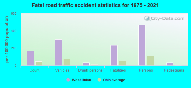
West Union fatal accident list:
Dec 27, 2015 05:08 PM, Sr-247, Lat: 38.801961, Lon: -83.546750, Vehicles: 2, Persons: 3, Fatalities: 2
Jul 22, 2002 05:41 PM, Sr-41, Vehicles: 3, Persons: 5, Fatalities: 1
Nov 2, 2002 02:05 AM, Cherry St, Vehicles: 1, Persons: 2, Fatalities: 1, Drunk persons involved: 1
May 9, 1980 04:00 PM, Vehicles: 2, Persons: 3, Fatalities: 2
- National Bridge Inventory (NBI) Statistics
- 19Number of bridges
- 125ft / 38.0mTotal length
- 28,105Total average daily traffic
- 1,964Total average daily truck traffic
- 39,008Total future (year 2035) average daily traffic
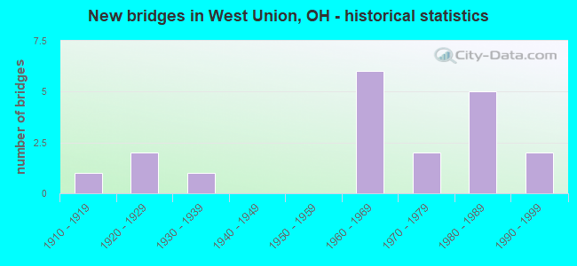
- New bridges - historical statistics
- 11910-1919
- 21920-1929
- 11930-1939
- 61960-1969
- 21970-1979
- 51980-1989
- 21990-1999
FCC Registered Cell Phone Towers:
2 (See the full list of FCC Registered Cell Phone Towers in West Union)FCC Registered Antenna Towers:
71 (See the full list of FCC Registered Antenna Towers)FCC Registered Broadcast Land Mobile Towers:
24 (See the full list of FCC Registered Broadcast Land Mobile Towers in West Union, OH)FCC Registered Microwave Towers:
16 (See the full list of FCC Registered Microwave Towers in this town)FCC Registered Maritime Coast & Aviation Ground Towers:
3 (See the full list of FCC Registered Maritime Coast & Aviation Ground Towers)FCC Registered Amateur Radio Licenses:
88 (See the full list of FCC Registered Amateur Radio Licenses in West Union)FAA Registered Aircraft:
5- Aircraft: PIPER PA-23-150 (Category: Land, Engines: 2, Seats: 5, Weight: Up to 12,499 Pounds, Speed: 150 mph), Engine: LYCOMING 0-320 SERIES (180 HP) (Reciprocating)
N-Number: 2005P, N2005P, N-2005P, Serial Number: 23-574, Airworthiness Date: 05/18/1956, Certificate Issue Date: 05/07/2019
Registrant (Individual): Richard L Jr Davis, 821 Old Cincinnati Pike, West Union, OH 45693
Deregistered: Cancel Date: 03/12/2018 - Aircraft: AMERICAN AVIATION AA-1A (Category: Land, Seats: 2, Weight: Up to 12,499 Pounds, Speed: 84 mph), Engine: LYCOMING 0-235 SERIES (115 HP) (Reciprocating)
N-Number: 72PM, N72PM, N-72PM, Serial Number: AA1A-0426, Airworthiness Date: 06/21/1972, Certificate Issue Date: 05/07/2019
Registrant (Individual): Richard L Jr Davis, 821 Old Cincinnati Pike, West Union, OH 45693 - Aircraft: CESSNA 172C (Category: Land, Seats: 4, Weight: Up to 12,499 Pounds, Speed: 105 mph), Engine: CONT MOTOR 0-300 SER (145 HP) (Reciprocating)
N-Number: 8499X, N8499X, N-8499X, Serial Number: 17248999, Year manufactured: 1961, Airworthiness Date: 10/24/1961, Certificate Issue Date: 10/09/2018
Registrant (Individual): Joseph T Brumley, 654 Cooper Rd, West Union, OH 45693 - Aircraft: WESTERN IMPLEMENT KITFOX 3 (Category: Land, Seats: 2, Weight: Up to 12,499 Pounds), Engine: Reciprocating
N-Number: 1008B, N1008B, N-1008B, Serial Number: 1008, Certificate Issue Date: 08/27/2012
Registrant (Individual): Stephen R Jr Sanada, 3810 Island Creek Rd, West Union, OH 45693
Deregistered: Cancel Date: 01/29/2019 - Aircraft: MICHAEL MURRAY PRP 2000 (Category: Land, Seats: 2, Weight: Up to 12,499 Pounds), Engine: Reciprocating
N-Number: 43453, N43453, N-43453, Serial Number: HM3, Certificate Issue Date: 01/28/2015
Registrant (Corporation): Total Living Ministries Inc, 53 Hull Rd, West Union, OH 45693
Deregistered: Cancel Date: 08/27/2008
2002 - 2018 National Fire Incident Reporting System (NFIRS) incidents
- Fire incident types reported to NFIRS in West Union, OH
- 1,15960.7%Structure Fires
- 52727.6%Outside Fires
- 21611.3%Mobile Property/Vehicle Fires
- 70.4%Other
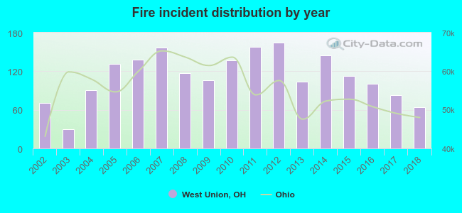 According to the data from the years 2002 - 2018 the average number of fire incidents per year is 112. The highest number of fires - 164 took place in 2012, and the least - 30 in 2003. The data has a declining trend.
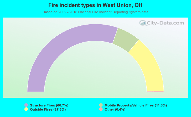 When looking into fire subcategories, the most incidents belonged to: Structure Fires (60.7%), and Outside Fires (27.6%).
| Most common first names in West Union, OH among deceased individuals | ||
| Name | Count | Lived (average) |
|---|---|---|
| Mary | 81 | 82.2 years |
| William | 78 | 77.2 years |
| John | 72 | 74.6 years |
| James | 63 | 69.1 years |
| Robert | 43 | 69.8 years |
| Charles | 40 | 73.8 years |
| Harry | 34 | 78.2 years |
| George | 32 | 77.0 years |
| Ruth | 26 | 81.1 years |
| Anna | 25 | 81.9 years |
| Most common last names in West Union, OH among deceased individuals | ||
| Last name | Count | Lived (average) |
|---|---|---|
| Grooms | 98 | 78.5 years |
| Young | 45 | 80.0 years |
| Moore | 27 | 76.1 years |
| Scott | 26 | 79.0 years |
| Hayslip | 26 | 81.6 years |
| Taylor | 24 | 73.7 years |
| Jones | 24 | 78.6 years |
| Campbell | 21 | 74.5 years |
| Smith | 20 | 79.2 years |
| Davis | 20 | 80.7 years |
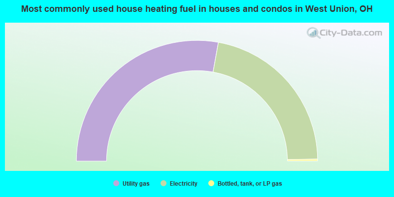
- 55.7%Utility gas
- 43.8%Electricity
- 0.5%Bottled, tank, or LP gas
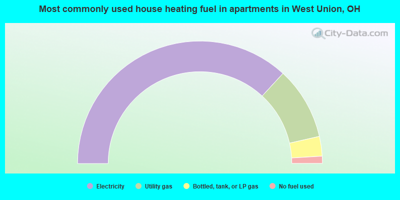
- 73.7%Electricity
- 19.2%Utility gas
- 5.2%Bottled, tank, or LP gas
- 1.9%No fuel used
West Union compared to Ohio state average:
- Median household income below state average.
- Median house value below state average.
- Unemployed percentage below state average.
- Black race population percentage significantly below state average.
- Hispanic race population percentage below state average.
- Foreign-born population percentage significantly below state average.
- Renting percentage above state average.
- Length of stay since moving in below state average.
- Institutionalized population percentage significantly above state average.
- Percentage of population with a bachelor's degree or higher below state average.

|
Total of 5 patent applications in 2008-2024.