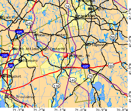
Raynham, Massachusetts
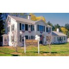
Raynham: Historic Hannant House, Raynham,MA - Decorated for July 4th, USA Independence Day!
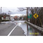
Raynham: Taunton River Over flows during SPRING FLOOD 2010, Taunton Raynham Line
- add
your
Submit your own pictures of this town and show them to the world
- OSM Map
- General Map
- Google Map
- MSN Map
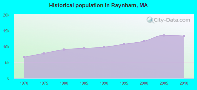
Population change since 2000: +14.0%
 |
| Males: 6,523 | |
| Females: 6,860 |
| Median resident age: | 41.2 years |
| Massachusetts median age: | 39.2 years |
Zip codes: 02767.
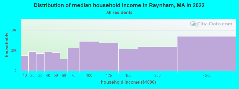
| Raynham: | $113,336 |
| MA: | $94,488 |
Estimated per capita income in 2022: $49,909 (it was $24,476 in 2000)
Raynham town income, earnings, and wages data
Estimated median house or condo value in 2022: $497,784 (it was $169,500 in 2000)
| Raynham: | $497,784 |
| MA: | $534,700 |
Mean prices in 2022: all housing units: $449,660; detached houses: $484,124; townhouses or other attached units: $382,766; in 2-unit structures: $322,469; in 3-to-4-unit structures: $355,875; in 5-or-more-unit structures: $269,714; mobile homes: $156,871; occupied boats, rvs, vans, etc.: $49,834
Detailed information about poverty and poor residents in Raynham, MA


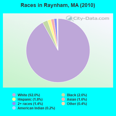
- 12,31992.0%White alone
- 3442.6%Black alone
- 2471.8%Hispanic
- 2091.6%Asian alone
- 1831.4%Two or more races
- 580.4%Other race alone
- 230.2%American Indian alone
Races in Raynham detailed stats: ancestries, foreign born residents, place of birth
According to our research of Massachusetts and other state lists, there were 4 registered sex offenders living in Raynham, Massachusetts as of April 26, 2024.
The ratio of all residents to sex offenders in Raynham is 3,346 to 1.
The ratio of registered sex offenders to all residents in this city is lower than the state average.
Type |
2009 |
2010 |
2011 |
2012 |
2013 |
2014 |
2015 |
2016 |
2017 |
2018 |
2019 |
2020 |
2021 |
2022 |
|---|---|---|---|---|---|---|---|---|---|---|---|---|---|---|
| Murders (per 100,000) | 0 (0.0) | 0 (0.0) | 0 (0.0) | 0 (0.0) | 0 (0.0) | 0 (0.0) | 0 (0.0) | 0 (0.0) | 0 (0.0) | 0 (0.0) | 0 (0.0) | 0 (0.0) | 0 (0.0) | 0 (0.0) |
| Rapes (per 100,000) | 2 (14.2) | 0 (0.0) | 2 (14.9) | 2 (14.8) | 2 (14.7) | 3 (22.0) | 1 (7.3) | 3 (21.7) | 6 (42.7) | 1 (7.0) | 4 (27.9) | 4 (27.6) | 5 (33.8) | 6 (39.0) |
| Robberies (per 100,000) | 12 (85.3) | 4 (29.9) | 13 (96.5) | 5 (37.0) | 9 (66.3) | 5 (36.7) | 7 (50.8) | 4 (28.9) | 4 (28.5) | 1 (7.0) | 4 (27.9) | 4 (27.6) | 4 (27.0) | 2 (13.0) |
| Assaults (per 100,000) | 17 (120.8) | 22 (164.4) | 17 (126.3) | 12 (88.8) | 15 (110.5) | 18 (132.0) | 17 (123.4) | 21 (152.0) | 23 (163.7) | 25 (174.6) | 20 (139.6) | 13 (89.6) | 22 (148.7) | 14 (90.9) |
| Burglaries (per 100,000) | 70 (497.6) | 62 (463.3) | 78 (579.3) | 48 (355.1) | 68 (500.7) | 37 (271.4) | 33 (239.6) | 26 (188.2) | 43 (306.1) | 20 (139.7) | 12 (83.8) | 8 (55.1) | 11 (74.3) | 9 (58.4) |
| Thefts (per 100,000) | 305 (2,168) | 262 (1,958) | 253 (1,879) | 272 (2,012) | 310 (2,283) | 237 (1,738) | 274 (1,990) | 220 (1,592) | 178 (1,267) | 198 (1,383) | 183 (1,278) | 130 (895.8) | 94 (635.2) | 141 (915.3) |
| Auto thefts (per 100,000) | 19 (135.1) | 9 (67.2) | 17 (126.3) | 19 (140.6) | 17 (125.2) | 15 (110.0) | 14 (101.7) | 26 (188.2) | 11 (78.3) | 17 (118.7) | 15 (104.7) | 8 (55.1) | 7 (47.3) | 11 (71.4) |
| Arson (per 100,000) | 0 (0.0) | 2 (14.9) | 1 (7.4) | 0 (0.0) | 1 (7.4) | 0 (0.0) | 1 (7.3) | 0 (0.0) | 0 (0.0) | 0 (0.0) | 0 (0.0) | 0 (0.0) | 0 (0.0) | 0 (0.0) |
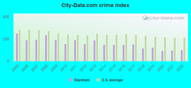
| City-Data.com crime index | 193.5 | 158.0 | 191.9 | 157.3 | 190.1 | 152.3 | 150.2 | 148.4 | 153.8 | 117.2 | 124.0 | 92.3 | 99.3 | 99.6 |
The City-Data.com crime index weighs serious crimes and violent crimes more heavily. Higher means more crime, U.S. average is 246.1. It adjusts for the number of visitors and daily workers commuting into cities.
Crime rate in Raynham detailed stats: murders, rapes, robberies, assaults, burglaries, thefts, arson
Full-time law enforcement employees in 2021, including police officers: 38 (30 officers - 26 male; 4 female).
| Officers per 1,000 residents here: | 2.03 |
| Massachusetts average: | 2.53 |
 Recent articles from our blog. Our writers, many of them Ph.D. graduates or candidates, create easy-to-read articles on a wide variety of topics.

 | Quincy to open "migrant" shelter in Wollaston (251 replies) |
| 2023 Real Estate Observations (5278 replies) |
| Resistance to multifamily housing law (67 replies) |
| Communities to move to in .the Brockton Area: East Bridgewater Raynham Stoughton (6 replies) |
| Do 24 hour grocery stores not exist in New England? (112 replies) |
| Individual Votes By Cities/Towns Whether To Allow Marijuana businesses (599 replies) |
Latest news from Raynham, MA collected exclusively by city-data.com from local newspapers, TV, and radio stations
Ancestries: Irish (28.4%), Italian (15.6%), English (14.8%), Portuguese (13.4%), French (10.5%), German (5.8%).
Current Local Time: EST time zone
Incorporated in 1731
Elevation: 81 feet
Land area: 20.5 square miles.
Population density: 653 people per square mile (low).

664 residents are foreign born (3.2% Europe, 1.6% Asia).
| This town: | 5.7% |
| Massachusetts: | 12.2% |
| Raynham town: | 1.4% ($2,298) |
| Massachusetts: | 1.3% ($2,336) |
Nearest city with pop. 50,000+: Taunton, MA  (3.3 miles , pop. 55,976).
Nearest city with pop. 200,000+: Boston, MA (27.1 miles , pop. 589,141).
Nearest city with pop. 1,000,000+: Bronx, NY (164.9 miles , pop. 1,332,650).
Nearest cities:
), ), ), ), ), ), Latitude: 41.93 N, Longitude: 71.04 W

Raynham, Massachusetts accommodation & food services, waste management - Economy and Business Data
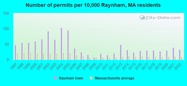
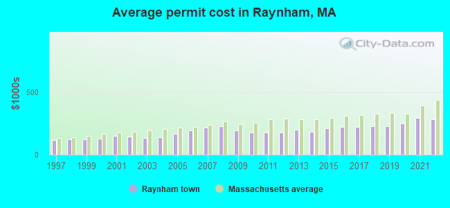
Single-family new house construction building permits:
- 2022: 39 buildings, average cost: $280,900
- 2021: 47 buildings, average cost: $291,900
- 2020: 36 buildings, average cost: $249,100
- 2019: 33 buildings, average cost: $224,300
- 2018: 36 buildings, average cost: $227,400
- 2017: 36 buildings, average cost: $219,500
- 2016: 35 buildings, average cost: $221,500
- 2015: 28 buildings, average cost: $211,300
- 2014: 37 buildings, average cost: $184,600
- 2013: 57 buildings, average cost: $200,100
- 2012: 25 buildings, average cost: $175,800
- 2011: 19 buildings, average cost: $178,700
- 2010: 24 buildings, average cost: $174,700
- 2009: 9 buildings, average cost: $195,700
- 2008: 20 buildings, average cost: $225,800
- 2007: 29 buildings, average cost: $216,000
- 2006: 43 buildings, average cost: $193,600
- 2005: 111 buildings, average cost: $168,300
- 2004: 122 buildings, average cost: $138,700
- 2003: 78 buildings, average cost: $133,300
- 2002: 109 buildings, average cost: $143,300
- 2001: 79 buildings, average cost: $147,400
- 2000: 71 buildings, average cost: $126,500
- 1999: 66 buildings, average cost: $118,700
- 1998: 66 buildings, average cost: $120,000
- 1997: 56 buildings, average cost: $117,600
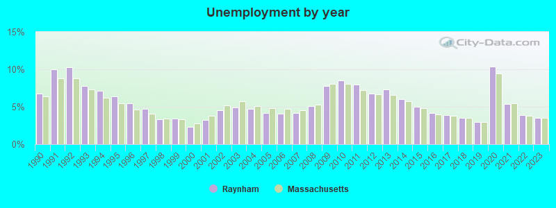
| Here: | 3.5% |
| Massachusetts: | 3.5% |
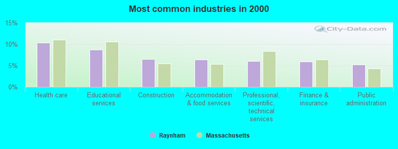
- Health care (10.3%)
- Educational services (8.7%)
- Construction (6.6%)
- Accommodation & food services (6.4%)
- Professional, scientific, technical services (6.1%)
- Finance & insurance (5.9%)
- Public administration (5.3%)
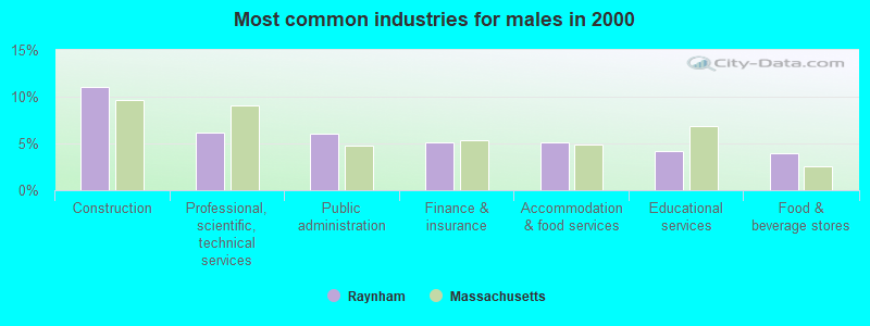
- Construction (11.1%)
- Professional, scientific, technical services (6.1%)
- Public administration (6.0%)
- Finance & insurance (5.1%)
- Accommodation & food services (5.1%)
- Educational services (4.2%)
- Food & beverage stores (4.0%)
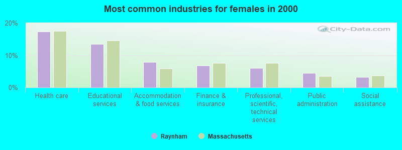
- Health care (17.3%)
- Educational services (13.6%)
- Accommodation & food services (7.9%)
- Finance & insurance (6.8%)
- Professional, scientific, technical services (6.0%)
- Public administration (4.4%)
- Social assistance (3.3%)
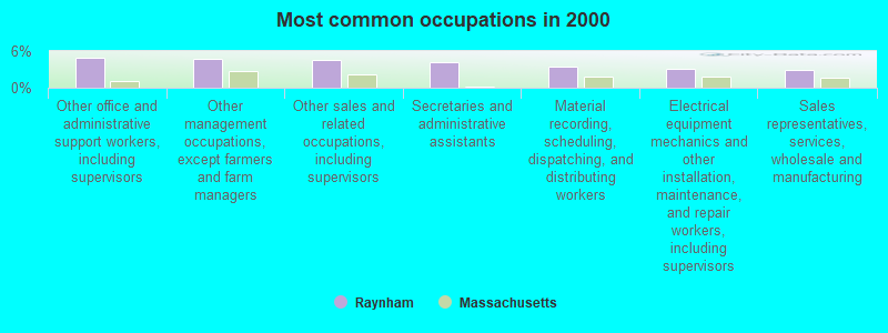
- Other office and administrative support workers, including supervisors (5.0%)
- Other management occupations, except farmers and farm managers (4.6%)
- Other sales and related occupations, including supervisors (4.5%)
- Secretaries and administrative assistants (4.2%)
- Material recording, scheduling, dispatching, and distributing workers (3.5%)
- Electrical equipment mechanics and other installation, maintenance, and repair workers, including supervisors (3.1%)
- Sales representatives, services, wholesale and manufacturing (2.8%)
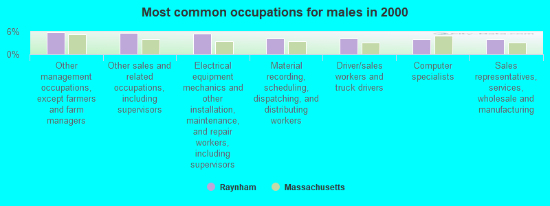
- Other management occupations, except farmers and farm managers (5.8%)
- Other sales and related occupations, including supervisors (5.7%)
- Electrical equipment mechanics and other installation, maintenance, and repair workers, including supervisors (5.4%)
- Material recording, scheduling, dispatching, and distributing workers (4.2%)
- Driver/sales workers and truck drivers (4.2%)
- Computer specialists (4.0%)
- Sales representatives, services, wholesale and manufacturing (4.0%)
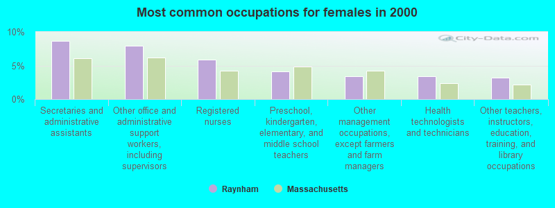
- Secretaries and administrative assistants (8.7%)
- Other office and administrative support workers, including supervisors (8.0%)
- Registered nurses (5.8%)
- Preschool, kindergarten, elementary, and middle school teachers (4.1%)
- Other management occupations, except farmers and farm managers (3.4%)
- Health technologists and technicians (3.4%)
- Other teachers, instructors, education, training, and library occupations (3.2%)
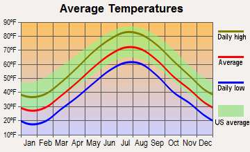
Average climate in Raynham, Massachusetts
Based on data reported by over 4,000 weather stations


(lower is better)
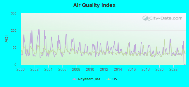
Air Quality Index (AQI) level in 2022 was 67.2. This is about average.
| City: | 67.2 |
| U.S.: | 72.6 |
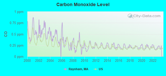
Carbon Monoxide (CO) [ppm] level in 2022 was 0.196. This is better than average. Closest monitor was 17.5 miles away from the city center.
| City: | 0.196 |
| U.S.: | 0.251 |
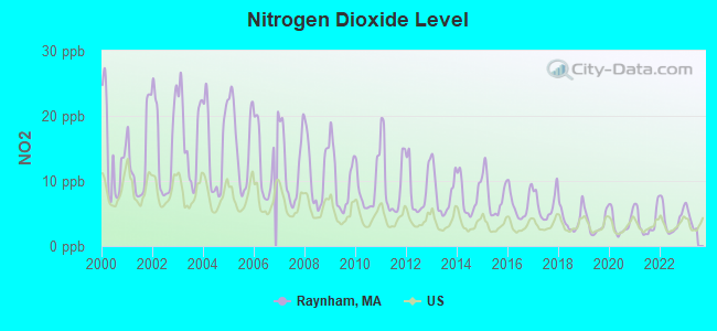
Nitrogen Dioxide (NO2) [ppb] level in 2022 was 4.03. This is better than average. Closest monitor was 3.1 miles away from the city center.
| City: | 4.03 |
| U.S.: | 5.11 |
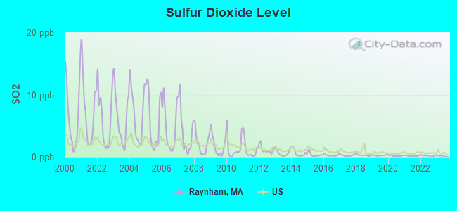
Sulfur Dioxide (SO2) [ppb] level in 2022 was 0.179. This is significantly better than average. Closest monitor was 3.1 miles away from the city center.
| City: | 0.179 |
| U.S.: | 1.515 |
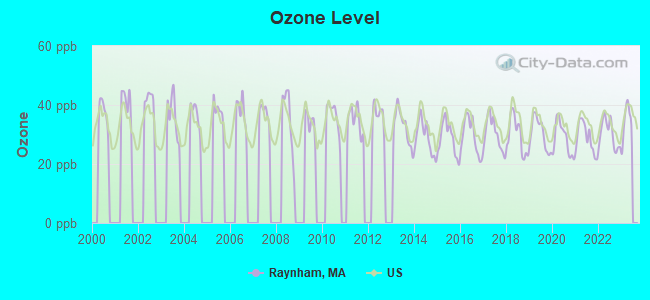
Ozone [ppb] level in 2022 was 30.2. This is about average. Closest monitor was 9.4 miles away from the city center.
| City: | 30.2 |
| U.S.: | 33.3 |
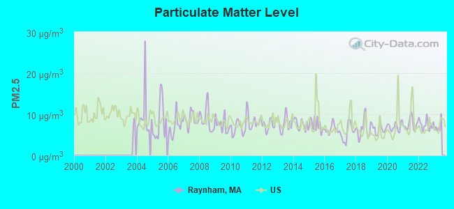
Particulate Matter (PM2.5) [µg/m3] level in 2022 was 7.51. This is about average. Closest monitor was 9.4 miles away from the city center.
| City: | 7.51 |
| U.S.: | 8.11 |
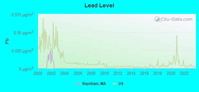
Lead (Pb) [µg/m3] level in 2001 was 0.0153. This is significantly worse than average. Closest monitor was 10.3 miles away from the city center.
| City: | 0.0153 |
| U.S.: | 0.0093 |
Tornado activity:
Raynham-area historical tornado activity is slightly below Massachusetts state average. It is 57% smaller than the overall U.S. average.
On 6/9/1953, a category F3 (max. wind speeds 158-206 mph) tornado 11.5 miles away from the Raynham town center injured 17 people and caused between $500,000 and $5,000,000 in damages.
On 6/9/1953, a category F4 (max. wind speeds 207-260 mph) tornado 35.3 miles away from the town center killed 90 people and injured 1228 people and caused between $50,000,000 and $500,000,000 in damages.
Earthquake activity:
Raynham-area historical earthquake activity is significantly above Massachusetts state average. It is 74% smaller than the overall U.S. average.On 10/7/1983 at 10:18:46, a magnitude 5.3 (5.1 MB, 5.3 LG, 5.1 ML, Class: Moderate, Intensity: VI - VII) earthquake occurred 217.8 miles away from Raynham center
On 4/20/2002 at 10:50:47, a magnitude 5.3 (5.3 ML, Depth: 3.0 mi) earthquake occurred 223.0 miles away from the city center
On 1/19/1982 at 00:14:42, a magnitude 4.7 (4.5 MB, 4.7 MD, 4.5 LG, Class: Light, Intensity: IV - V) earthquake occurred 112.1 miles away from the city center
On 10/16/2012 at 23:12:25, a magnitude 4.7 (4.7 ML, Depth: 10.0 mi) earthquake occurred 116.9 miles away from the city center
On 4/20/2002 at 10:50:47, a magnitude 5.2 (5.2 MB, 4.2 MS, 5.2 MW, 5.0 MW) earthquake occurred 222.3 miles away from the city center
On 8/22/1992 at 12:20:32, a magnitude 4.8 (4.8 MB, 3.8 MS, 4.7 LG, Depth: 6.2 mi) earthquake occurred 199.1 miles away from the city center
Magnitude types: regional Lg-wave magnitude (LG), body-wave magnitude (MB), duration magnitude (MD), local magnitude (ML), surface-wave magnitude (MS), moment magnitude (MW)
Natural disasters:
The number of natural disasters in Bristol County (23) is greater than the US average (15).Major Disasters (Presidential) Declared: 12
Emergencies Declared: 11
Causes of natural disasters: Floods: 8, Hurricanes: 7, Storms: 5, Snows: 3, Snowstorms: 3, Winter Storms: 3, Blizzards: 2, Explosion: 1, Heavy Rain: 1, Snowfall: 1, Tropical Storm: 1, Wind: 1 (Note: some incidents may be assigned to more than one category).

Hospitals and medical centers in Raynham:
Other hospitals and medical centers near Raynham:
- GOLDEN LIVING CENTER-WEDGEMERE (Nursing Home, about 3 miles away; TAUNTON, MA)
- WEDGEMERE CONV HOME (Nursing Home, about 3 miles away; TAUNTON, MA)
- LONGMEADOW NURSING HOME (Nursing Home, about 3 miles away; TAUNTON, MA)
- MARIAN MANOR OF TAUNTON (Nursing Home, about 4 miles away; TAUNTON, MA)
- MORTON HOSPITAL Acute Care Hospitals (about 4 miles away; TAUNTON, MA)
- TAUNTON STATE HOSPITAL (Hospital, about 4 miles away; TAUNTON, MA)
- MORTON HOME CARE (Home Health Center, about 5 miles away; TAUNTON, MA)
Operable nuclear power plant near Raynham:
- 20 miles: Pilgrim in Plymouth, MA.
Colleges/universities with over 2000 students nearest to Raynham:
- Bridgewater State University (about 6 miles; Bridgewater, MA; Full-time enrollment: 9,802)
- Stonehill College (about 10 miles; Easton, MA; FT enrollment: 2,563)
- Massasoit Community College (about 11 miles; Brockton, MA; FT enrollment: 5,442)
- Bristol Community College (about 16 miles; Fall River, MA; FT enrollment: 5,707)
- Brown University (about 20 miles; Providence, RI; FT enrollment: 8,458)
- Rhode Island School of Design (about 21 miles; Providence, RI; FT enrollment: 2,714)
- Johnson & Wales University-Providence (about 21 miles; Providence, RI; FT enrollment: 10,898)
Public elementary/middle schools in Raynham:
- RAYNHAM MIDDLE SCHOOL (Students: 805, Location: 420 TITICUT RD, Grades: 5-8)
- LALIBERTE ELEMENTARY SCHOOL (Students: 546, Location: 777 PLEASANT STREET, Grades: 2-4)
- MERRILL ELEMENTARY SCHOOL (Students: 410, Location: 687 PLEASANT STREET, Grades: KG-1)
Library in Raynham:
- RAYNHAM PUBLIC LIBRARY (Operating income: $306,626; Location: 760 SOUTH MAIN ST.; 36,526 books; 523 e-books; 3,009 audio materials; 1,820 video materials; 3 local licensed databases; 34 state licensed databases; 1 other licensed databases; 50 print serial subscriptions; 1 electronic serial subscriptions)
Points of interest:
Notable locations in Raynham: Raynham Racetrack (A), Cape Road Plaza (B), Raynham Fire Department (C), Raynham Townhall (D). Display/hide their locations on the map
Shopping Centers: Raynham Shopping Center (1), Bay Colony Shopping Center (2). Display/hide their locations on the map
Churches in Raynham include: Saint Anns Church (A), Raynham Church (B). Display/hide their locations on the map
Cemetery: Raynham Cemetery (1). Display/hide its location on the map
Lakes, reservoirs, and swamps: Kings Pond (A), Jones Pond (B), Hewitt Pond (C), Gushee Pond (D), Wilbur Pond (E), Tracy Pond (F), Johnson Pond (G), Forge River Reservoir (H). Display/hide their locations on the map
Streams, rivers, and creeks: Damlot Brook (A), Pine Swamp Brook (B), Forge River (C), Dam Lot Brook (D), Bassett Brook (E), Furnance Brook (F). Display/hide their locations on the map
Tourist attraction: Raynham Flea Market (Cultural Attractions- Events- & Facilities; Corner Judson & South St) (1). Display/hide its approximate location on the map
Hotels: Courtyard by Marriott (37 Paramount Drive) (1), Hampton Inn Raynham (600 New State Highway) (2). Display/hide their approximate locations on the map
Birthplace of: Ezra Lincoln - Baseball player, John J. O'Connor - Politician, Tim Donahue - Major League Baseball player.
Drinking water stations with addresses in Raynham and their reported violations in the past:
SCHOONER PASS TRUSTEES CONDOMINIUMS (Address: ATTN: RUSS YULE, PO 77 , Population served: 94, Purch groundwater):Past monitoring violations:
- One routine major monitoring violation
Drinking water stations with addresses in Raynham that have no violations reported:
- RAYNHAM CENTER WATER DISTRICT (Population served: 9,768, Primary Water Source Type: Groundwater)
- NORTH RAYNHAM WATER DISTRICT (Population served: 3,875, Primary Water Source Type: Groundwater)
| This town: | 2.7 people |
| Massachusetts: | 2.5 people |
| This town: | 74.2% |
| Whole state: | 63.0% |
| This town: | 6.3% |
| Whole state: | 7.0% |
Likely homosexual households (counted as self-reported same-sex unmarried-partner households)
- Lesbian couples: 0.4% of all households
- Gay men: 0.4% of all households
| This town: | 4.1% |
| Whole state: | 9.3% |
| This town: | 1.9% |
| Whole state: | 4.4% |
People in group quarters in Raynham in 2010:
- 145 people in nursing facilities/skilled-nursing facilities
- 9 people in residential treatment centers for adults
- 3 people in group homes intended for adults
People in group quarters in Raynham in 2000:
- 144 people in nursing homes
- 10 people in homes for the mentally retarded
- 2 people in religious group quarters
Banks with branches in Raynham (2011 data):
- Bristol County Savings Bank: Raynham Branch at 942 Broadway (Route 138), branch established on 1982/04/05; Raynham Branch at 108 North Main Street, branch established on 1976/10/02. Info updated 2007/09/11: Bank assets: $1,338.8 mil, Deposits: $1,027.4 mil, headquarters in Taunton, MA, positive income, Commercial Lending Specialization, 13 total offices, Holding Company: Beacon Bancorp
- Rockland Trust Company: Raynham Branch at 275 New State Highway, branch established on 2004/10/12. Info updated 2009/05/20: Bank assets: $4,974.4 mil, Deposits: $3,903.9 mil, headquarters in Rockland, MA, positive income, Commercial Lending Specialization, 67 total offices, Holding Company: Independent Bank Corp.
- Sovereign Bank, National Association: Raynham Branch at 310 New State Highway, branch established on 1965/12/16. Info updated 2012/01/31: Bank assets: $78,146.9 mil, Deposits: $48,042.9 mil, headquarters in Wilmington, DE, positive income, Commercial Lending Specialization, 718 total offices, Holding Company: Banco Santander, S.A.
- Bank of America, National Association: Raynham Branch at 300 Route 44, branch established on 2002/09/30. Info updated 2009/11/18: Bank assets: $1,451,969.3 mil, Deposits: $1,077,176.8 mil, headquarters in Charlotte, NC, positive income, 5782 total offices, Holding Company: Bank Of America Corporation
- RBS Citizens, National Association: Raynham Stop And Shop at 36 New Cape Hwy, branch established on 2002/10/01. Info updated 2007/09/19: Bank assets: $106,940.6 mil, Deposits: $75,690.2 mil, headquarters in Providence, RI, positive income, 1135 total offices, Holding Company: Uk Financial Investments Limited
- Admirals Bank: Paramount Drive Branch at 36 Paramount Drive, branch established on 2004/03/22. Info updated 2011/07/21: Bank assets: $518.7 mil, Deposits: $462.0 mil, headquarters in Cranston, RI, positive income, Commercial Lending Specialization, 12 total offices
- Bridgewater Savings Bank: at 756 Orchard Street, branch established on 1872/03/19. Info updated 2010/02/03: Bank assets: $491.1 mil, Deposits: $376.9 mil, local headquarters, positive income, Commercial Lending Specialization, 10 total offices, Holding Company: Bridgewater Financial, Mhc
For population 15 years and over in Raynham:
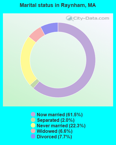
- Never married: 22.3%
- Now married: 61.5%
- Separated: 2.0%
- Widowed: 6.6%
- Divorced: 7.7%
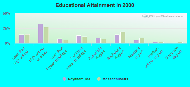
For population 25 years and over in Raynham:
- High school or higher: 85.3%
- Bachelor's degree or higher: 23.3%
- Graduate or professional degree: 8.9%
- Unemployed: 3.2%
- Mean travel time to work (commute): 28.2 minutes
| Here: | 11.5 |
| Massachusetts average: | 13.1 |
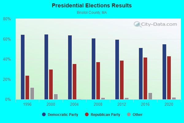
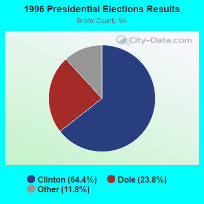
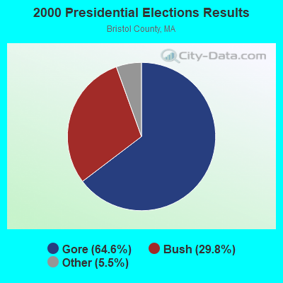
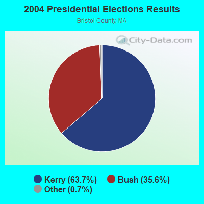
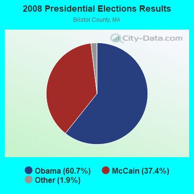
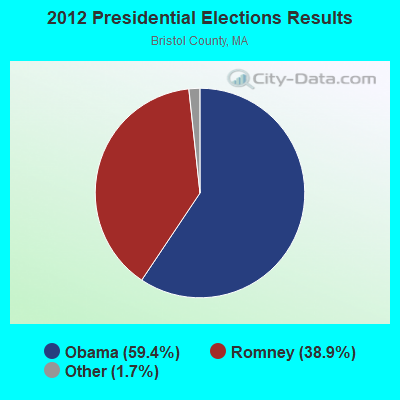
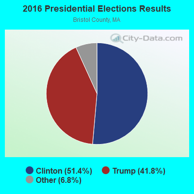
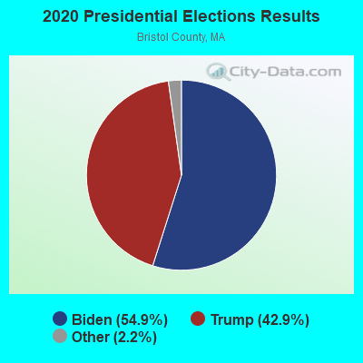
Graphs represent county-level data. Detailed 2008 Election Results
Religion statistics for Raynham, MA (based on Bristol County data)
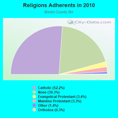
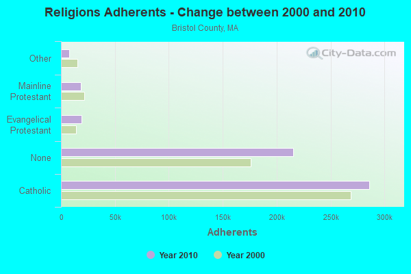
| Religion | Adherents | Congregations |
|---|---|---|
| Catholic | 286,113 | 72 |
| Evangelical Protestant | 18,765 | 128 |
| Mainline Protestant | 18,246 | 83 |
| Other | 7,807 | 33 |
| Orthodox | 1,565 | 4 |
| Black Protestant | 511 | 5 |
| None | 215,278 | - |
Food Environment Statistics:
| This county: | 2.00 / 10,000 pop. |
| Massachusetts: | 1.98 / 10,000 pop. |
| Bristol County: | 0.09 / 10,000 pop. |
| Massachusetts: | 0.05 / 10,000 pop. |
| Bristol County: | 1.93 / 10,000 pop. |
| Massachusetts: | 2.22 / 10,000 pop. |
| This county: | 2.35 / 10,000 pop. |
| Massachusetts: | 1.77 / 10,000 pop. |
| Bristol County: | 8.20 / 10,000 pop. |
| State: | 8.76 / 10,000 pop. |
| Bristol County: | 9.5% |
| Massachusetts: | 8.1% |
| Bristol County: | 26.9% |
| State: | 22.5% |
| This county: | 14.4% |
| Massachusetts: | 16.5% |
4.76% of this county's 2021 resident taxpayers lived in other counties in 2020 ($70,162 average adjusted gross income)
| Here: | 4.76% |
| Massachusetts average: | 6.35% |
0.01% of residents moved from foreign countries ($64 average AGI)
Bristol County: 0.01% Massachusetts average: 0.01%
Top counties from which taxpayers relocated into this county between 2020 and 2021:
| from Plymouth County, MA | |
| from Norfolk County, MA | |
| from Providence County, RI |
4.63% of this county's 2020 resident taxpayers moved to other counties in 2021 ($72,404 average adjusted gross income)
| Here: | 4.63% |
| Massachusetts average: | 7.18% |
0.01% of residents moved to foreign countries ($83 average AGI)
Bristol County: 0.01% Massachusetts average: 0.02%
Top counties to which taxpayers relocated from this county between 2020 and 2021:
| to Plymouth County, MA | |
| to Providence County, RI | |
| to Norfolk County, MA |
| Businesses in Raynham, MA | ||||
| Name | Count | Name | Count | |
|---|---|---|---|---|
| AT&T | 1 | Marshalls | 1 | |
| Ace Hardware | 1 | Mazda | 1 | |
| Applebee's | 1 | McDonald's | 2 | |
| Ashley Furniture | 1 | Nike | 1 | |
| AutoZone | 1 | Nissan | 1 | |
| Baskin-Robbins | 1 | Panera Bread | 1 | |
| Bed Bath & Beyond | 1 | Payless | 1 | |
| CVS | 2 | Quality | 1 | |
| Chevrolet | 1 | RadioShack | 1 | |
| DressBarn | 1 | Shaw's | 1 | |
| Dressbarn | 1 | Sprint Nextel | 1 | |
| Dunkin Donuts | 6 | Staples | 1 | |
| Fashion Bug | 1 | Stop & Shop | 1 | |
| FedEx | 3 | Subaru | 1 | |
| Firestone Complete Auto Care | 1 | Subway | 3 | |
| Ford | 1 | T-Mobile | 2 | |
| GameStop | 1 | Taco Bell | 1 | |
| Hilton | 1 | Toyota | 1 | |
| Honda | 1 | UPS | 5 | |
| Hyundai | 1 | Volkswagen | 1 | |
| IHOP | 1 | Walmart | 1 | |
| Lowe's | 1 | Wendy's | 1 | |
| Marriott | 1 | |||
Strongest AM radio stations in Raynham:
- WEEI (850 AM; 50 kW; BOSTON, MA; Owner: ENTERCOM BOSTON LICENSE, LLC)
- WBZ (1030 AM; 50 kW; BOSTON, MA; Owner: INFINITY BROADCASTING OPERATIONS, INC.)
- WALE (990 AM; 50 kW; GREENVILLE, RI; Owner: NORTH AMERICAN BROADCASTING CO., INC.)
- WBET (1460 AM; 5 kW; BROCKTON, MA; Owner: KJI BROADCASTING, LLC)
- WPEP (1570 AM; 1 kW; TAUNTON, MA; Owner: ANASTOS MEDIA GROUP, INC.)
- WRKO (680 AM; 50 kW; BOSTON, MA; Owner: ENTERCOM BOSTON LICENSE, LLC)
- WKOX (1200 AM; 50 kW; FRAMINGHAM, MA; Owner: CAPSTAR TX LIMITED PARTNERSHIP)
- WBIX (1060 AM; 40 kW; NATICK, MA; Owner: LANGER BROADCASTING CORPORATION)
- WWZN (1510 AM; 50 kW; BOSTON, MA; Owner: ROSE CITY RADIO CORPORATION)
- WAMG (890 AM; 25 kW; DEDHAM, MA; Owner: MEGA COMMUNICATIONS OF DEDHAM LICENSEE, LLC)
- WCRN (830 AM; 50 kW; WORCESTER, MA; Owner: CARTER BROADCASTING CORPORATION)
- WPRO (630 AM; 5 kW; PROVIDENCE, RI; Owner: CITADEL BROADCASTING COMPANY)
- WDDZ (550 AM; 5 kW; PAWTUCKET, RI; Owner: ABC, INC.)
Strongest FM radio stations in Raynham:
- WBOT (97.7 FM; BROCKTON, MA; Owner: RADIO ONE LICENSES, LLC)
- WWBB (101.5 FM; PROVIDENCE, RI; Owner: CLEAR CHANNEL BROADCASTING LICENSES, INC.)
- WSNE-FM (93.3 FM; TAUNTON, MA; Owner: CAPSTAR TX LIMITED PARTNERSHIP)
- WBMX (98.5 FM; BOSTON, MA; Owner: INFINITY RADIO OPERATIONS INC.)
- WBOS (92.9 FM; BROOKLINE, MA; Owner: GREATER BOSTON RADIO, INC.)
- WJMN (94.5 FM; BOSTON, MA; Owner: AMFM RADIO LICENSES, L.L.C.)
- WCRB (102.5 FM; WALTHAM, MA; Owner: CHARLES RIVER BROADCASTING WCRB LICE)
- WTKK (96.9 FM; BOSTON, MA; Owner: GREATER BOSTON RADIO, INC.)
- WROR-FM (105.7 FM; FRAMINGHAM, MA; Owner: GREATER BOSTON RADIO, INC.)
- WXKS-FM (107.9 FM; MEDFORD, MA; Owner: AMFM RADIO LICENSES, L.L.C.)
- WMJX (106.7 FM; BOSTON, MA; Owner: GREATER BOSTON RADIO, INC.)
- WGBH (89.7 FM; BOSTON, MA; Owner: WGBH EDUCATIONAL FOUNDATION)
- WBUR-FM (90.9 FM; BOSTON, MA; Owner: TRUSTEES OF BOSTON UNIVERSITY)
- WODS (103.3 FM; BOSTON, MA; Owner: INFINITY BROADCASTING OPERATIONS, INC.)
- WBRU (95.5 FM; PROVIDENCE, RI; Owner: BROWN BROADCASTING SERVICE, INC.)
- WHJY (94.1 FM; PROVIDENCE, RI; Owner: CAPSTAR TX LIMITED PARTNERSHIP)
- WPLM-FM (99.1 FM; PLYMOUTH, MA; Owner: PLYMOUTH ROCK BROADCASTING CO., INC.)
- WBCN (104.1 FM; BOSTON, MA; Owner: HEMISPHERE BROADCASTING CORPORATION)
- WZLX (100.7 FM; BOSTON, MA; Owner: INFINITY BROADCASTING CORPORATION OF BOSTON)
- W267AI (101.3 FM; BOSTON, MA; Owner: MCC BROADCASTING COMPANY, INC.)
TV broadcast stations around Raynham:
- WWDP (Channel 46; NORWELL, MA; Owner: NORWELL TELEVISION, LLC)
- WLNE-TV (Channel 6; NEW BEDFORD, MA; Owner: FREEDOM BROADCASTING OF SOUTHERN NEW ENGLAND, INC.)
- WPRI-TV (Channel 12; PROVIDENCE, RI; Owner: TVL BROADCASTING OF RHODE ISLAND, LLC)
- WNAC-TV (Channel 64; PROVIDENCE, RI; Owner: WNAC, LLC)
- WJAR (Channel 10; PROVIDENCE, RI; Owner: OUTLET BROADCASTING, INC.)
- WLWC (Channel 28; NEW BEDFORD, MA; Owner: C-28 FCC LICENSEE SUBSIDIARY, LLC)
- WSBE-TV (Channel 36; PROVIDENCE, RI; Owner: RHODE ISLAND PUBLIC TELECOM. AUTHORITY)
- WCVB-TV (Channel 5; BOSTON, MA; Owner: WCVB HEARST-ARGYLE TV, INC.)
- WGBH-TV (Channel 2; BOSTON, MA; Owner: WGBH EDUCATIONAL FOUNDATION)
- WHDH-TV (Channel 7; BOSTON, MA; Owner: WHDH-TV)
- WMFP (Channel 62; LAWRENCE, MA; Owner: WSAH LICENSE, INC.)
- WSBK-TV (Channel 38; BOSTON, MA; Owner: VIACOM INC.)
- WLVI-TV (Channel 56; CAMBRIDGE, MA; Owner: WLVI, INC.)
- WBZ-TV (Channel 4; BOSTON, MA; Owner: VIACOM INC.)
- WGBX-TV (Channel 44; BOSTON, MA; Owner: WGBH EDUCATIONAL FOUNDATION)
- WFXT (Channel 25; BOSTON, MA; Owner: FOX TELEVISION STATIONS INC.)
- WBPX (Channel 68; BOSTON, MA; Owner: PAXSON BOSTON-68 LICENSE, INC.)
- W40BO (Channel 40; BOSTON, MA; Owner: PAXSON COMMUNICATIONS LPTV, INC.)
- WPXQ (Channel 69; BLOCK ISLAND, RI; Owner: OCEAN STATE TELEVISION, L.L.C.)
- WUTF (Channel 66; MARLBOROUGH, MA; Owner: TELEFUTURA BOSTON LLC)
- WTMU-LP (Channel 32; BOSTON, MA; Owner: ZGS BOSTON, INC.)
- WCEA-LP (Channel 58; BOSTON, MA; Owner: CHANNEL 19 TV CORPORATION)
- WUNI (Channel 27; WORCESTER, MA; Owner: ENTRAVISION HOLDINGS, LLC)
- WRIW-LP (Channel 50; PROVIDENCE, RI; Owner: ZGS PROVIDENCE, INC.)
- National Bridge Inventory (NBI) Statistics
- 18Number of bridges
- 223ft / 68.1mTotal length
- $23,428,000Total costs
- 326,866Total average daily traffic
- 18,727Total average daily truck traffic
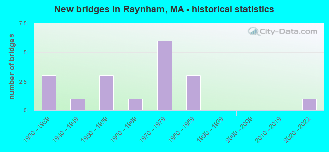
- New bridges - historical statistics
- 31930-1939
- 11940-1949
- 31950-1959
- 11960-1969
- 61970-1979
- 31980-1989
- 12020-2022
FCC Registered Cell Phone Towers:
1 (See the full list of FCC Registered Cell Phone Towers in Raynham)FCC Registered Antenna Towers:
55 (See the full list of FCC Registered Antenna Towers)FCC Registered Broadcast Land Mobile Towers:
12 (See the full list of FCC Registered Broadcast Land Mobile Towers in Raynham, MA)FCC Registered Microwave Towers:
6- RAYNHAM, 185 Pine St (Lat: 41.938694 Lon: -71.010583), Overall height: 57.3 m, Call Sign: WMQ366,
Assigned Frequencies: 10628.1 MHz, Grant Date: 02/23/2011, Expiration Date: 02/01/2021, Cancellation Date: 07/23/2014, Certifier: Carol L Tacker, Registrant: At&t Mobility LLC, 1120 20th Street, Nw - Suite 1000, Washington, DC 20036, Phone: (202) 457-2055, Fax: (202) 457-3073, Email:
- RAYNHAM, Pine St (Lat: 41.938722 Lon: -71.010889), Type: Tower, Structure height: 57.6 m, Call Sign: WLW642,
Assigned Frequencies: 6256.54 MHz, 11365.0 MHz, Grant Date: 01/11/2011, Expiration Date: 02/01/2021, Cancellation Date: 08/17/2015, Registrant: Verizon Wireless, 1120 Sanctuary Pkwy, #150 Gasa5reg, Alpharetta, GA 30009-7630, Phone: (770) 797-1070, Fax: (770) 797-1036, Email:
- BOS1510, 1588 Broadway St (Lat: 41.970722 Lon: -71.068167), Type: Tower, Structure height: 60.6 m, Call Sign: WQHK462, Licensee ID: L01728370,
Assigned Frequencies: 10895.0 MHz, 11325.0 MHz, Grant Date: 08/21/2007, Expiration Date: 08/21/2017, Cancellation Date: 09/09/2013, Certifier: Joseph M Sandri Jr., Registrant: Fibertower Network Services, Corp., Debtor-In-Possession, 1875 Eye Street, Nw, 5th Floor, Room 505, Washington, DC 20006, Phone: (202) 223-1028, Email:
- BOS1516, Pine Street (Lat: 41.938583 Lon: -71.010778), Type: Tower, Structure height: 56.4 m, Call Sign: WQHK514, Licensee ID: L01728370,
Assigned Frequencies: 19540.0 MHz, 19620.0 MHz, Grant Date: 08/22/2007, Expiration Date: 08/22/2017, Cancellation Date: 09/09/2013, Certifier: Joseph M Sandri Jr., Registrant: Fibertower Network Services, Corp., Debtor-In-Possession, 1875 Eye Street, Nw, 5th Floor, Room 505, Washington, DC 20006, Phone: (202) 223-1028, Email:
- BOS1517, 678 Church Street (10339 / Raynham) (Lat: 41.901083 Lon: -71.007556), Type: Tower, Structure height: 46.3 m, Overall height: 48.7 m, Call Sign: WQHK515, Licensee ID: L01728370,
Assigned Frequencies: 18060.0 MHz, Grant Date: 08/22/2007, Expiration Date: 08/22/2017, Cancellation Date: 09/09/2013, Certifier: Joseph M Sandri Jr., Registrant: Fibertower Network Services, Corp., Debtor-In-Possession, 1875 Eye Street, Nw, 5th Floor, Room 505, Washington, DC 20006, Phone: (202) 223-1028, Email:
- Orchard St WT, Orchard Street (Lat: 41.906667 Lon: -71.038639), Type: Tank, Structure height: 30.5 m, Call Sign: WQVU792,
Assigned Frequencies: 17955.0 MHz, Grant Date: 05/14/2015, Expiration Date: 05/14/2025, Certifier: Edward J Walsh, Registrant: Cyber Communications, Inc, 100 Fireworks Circle, Bridgewater, MA 02324, Phone: (508) 880-3294, Fax: (508) 880-6745, Email:
FCC Registered Amateur Radio Licenses:
55 (See the full list of FCC Registered Amateur Radio Licenses in Raynham)FAA Registered Aircraft:
1- Aircraft: CESSNA 170A (Category: Land, Seats: 4, Weight: Up to 12,499 Pounds, Speed: 105 mph), Engine: CONT MOTOR C145 SERIES (145 HP) (Reciprocating)
N-Number: 5588C, N5588C, N-5588C, Serial Number: 19642, Year manufactured: 1950, Certificate Issue Date: 05/02/2012
Registrant (Individual): Stephen D Manchester, 25 Jennings Dr, Raynham, MA 02767
2002 - 2018 National Fire Incident Reporting System (NFIRS) incidents
- Fire incident types reported to NFIRS in Raynham, MA
- 63943.7%Outside Fires
- 39627.1%Structure Fires
- 32021.9%Mobile Property/Vehicle Fires
- 1087.4%Other
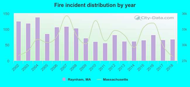 Based on the data from the years 2002 - 2018 the average number of fire incidents per year is 86. The highest number of fire incidents - 138 took place in 2004, and the least - 56 in 2011. The data has a dropping trend.
 When looking into fire subcategories, the most incidents belonged to: Outside Fires (43.7%), and Structure Fires (27.1%).
Fire-safe hotels and motels in Raynham, Massachusetts:
- Quality Inn, 164 New State Hwy, Raynham, Massachusetts 02767 , Phone: (508) 824-8647, Fax: (508) 824-1857
- Courtyard By Marriott, 37 Paramount Dr, Raynham, Massachusetts 02767 , Phone: (508) 822-8383, Fax: (508) 880-2627
- Hampton Inn Of Raynham, 600 New State Hwy, Raynham, Massachusetts 02767 , Phone: (508) 822-6222, Fax: (508) 821-3367
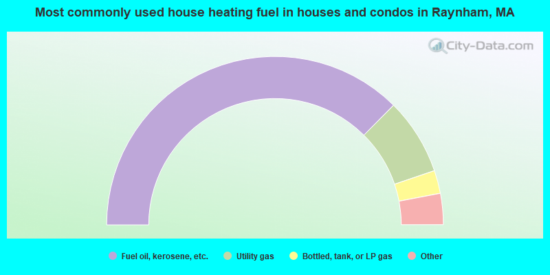
- 74.9%Fuel oil, kerosene, etc.
- 14.7%Utility gas
- 4.4%Bottled, tank, or LP gas
- 4.0%Electricity
- 1.5%Wood
- 0.3%Other fuel
- 0.2%Coal or coke
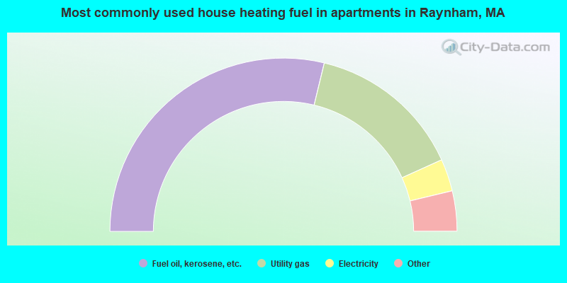
- 57.5%Fuel oil, kerosene, etc.
- 28.9%Utility gas
- 6.0%Electricity
- 2.6%Bottled, tank, or LP gas
- 2.6%No fuel used
- 2.4%Other fuel
Raynham compared to Massachusetts state average:
- Unemployed percentage significantly below state average.
- Black race population percentage below state average.
- Hispanic race population percentage significantly below state average.
- Foreign-born population percentage significantly below state average.
- Renting percentage below state average.
- Length of stay since moving in significantly above state average.
- Number of rooms per house significantly below state average.
- House age significantly below state average.
Raynham on our top lists:
- #27 on the list of "Top 101 cities with largest percentage of males in occupations: bookkeeping, accounting, and auditing clerks (population 5,000+)"
- #33 on the list of "Top 101 cities with largest percentage of females in industries: miscellaneous durable goods merchant wholesalers (population 5,000+)"
- #60 on the list of "Top 101 cities with largest percentage of males in industries: sporting goods, camera, and hobby and toy stores (population 5,000+)"
- #62 on the list of "Top 101 cities with largest percentage of males in industries: u. s. postal service (population 5,000+)"
- #66 on the list of "Top 101 cities with largest percentage of females in industries: alcoholic beverages merchant wholesalers (population 5,000+)"
- #69 on the list of "Top 101 cities with largest percentage of males in industries: groceries and related products merchant wholesalers (population 5,000+)"
- #85 on the list of "Top 101 cities with largest percentage of males in industries: personal and laundry services (population 5,000+)"
- #99 on the list of "Top 101 cities with largest percentage of males in occupations: printing workers (population 5,000+)"
- #14 on the list of "Top 101 counties with the lowest percentage of residents that keep firearms around their homes"
- #29 on the list of "Top 101 counties with the lowest percentage of residents relocating to foreign countries in 2011 (pop. 50,000+)"
- #32 on the list of "Top 101 counties with the most Catholic congregations"
- #34 on the list of "Top 101 counties with the highest percentage of residents that smoked 100+ cigarettes in their lives"
- #41 on the list of "Top 101 counties with the most Catholic adherents"

|
|
Total of 299 patent applications in 2008-2024.