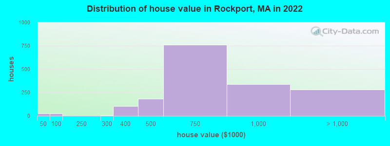
Estimated median house or condo value in 2022: $702,103 (it was $276,000 in 2000)
Rockport:
$702,103
MA:
$534,700
Mean prices in 2022:all housing units: $645,471; detached houses: $712,185; townhouses or other attached units: $551,275; in 2-unit structures: $503,219; in 3-to-4-unit structures: $450,535; in 5-or-more-unit structures: $352,534; mobile homes: $123,118; occupied boats, rvs, vans, etc.: $131,058
Median gross rent in 2022: $1,835.
March 2022 cost of living index in Rockport: 138.9 (high, U.S. average is 100)
According to our research of Massachusetts and other state lists, there was 1 registered sex offender living in Rockport, Massachusetts as of April 25, 2024. The ratio of all residents to sex offenders in Rockport is 5,165 to 1. The ratio of registered sex offenders to all residents in this city is much lower than the state average.
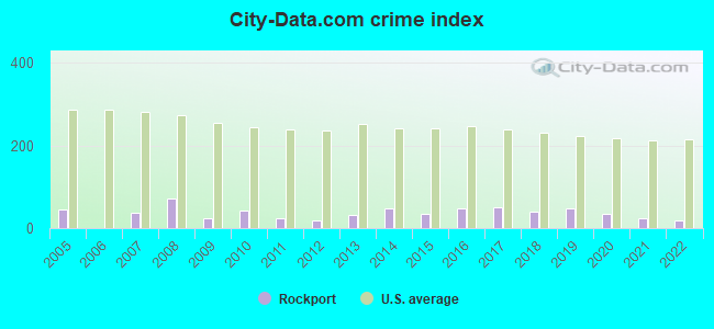
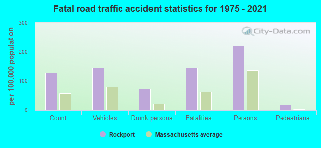
Crime rates in Rockport by year
Type
2009
2010
2011
2012
2013
2014
2015
2016
2017
2018
2019
2020
2021
2022
Murders (per 100,000)
0 (0.0)
0 (0.0)
0 (0.0)
0 (0.0)
0 (0.0)
0 (0.0)
0 (0.0)
0 (0.0)
0 (0.0)
0 (0.0)
0 (0.0)
0 (0.0)
0 (0.0)
0 (0.0)
Rapes (per 100,000)
0 (0.0)
2 (28.8)
1 (14.3)
0 (0.0)
1 (14.1)
2 (27.8)
0 (0.0)
3 (41.5)
3 (41.4)
2 (27.5)
2 (27.5)
0 (0.0)
0 (0.0)
1 (14.4)
Robberies (per 100,000)
0 (0.0)
0 (0.0)
0 (0.0)
0 (0.0)
1 (14.1)
0 (0.0)
1 (13.8)
1 (13.8)
0 (0.0)
0 (0.0)
1 (13.7)
1 (13.7)
1 (13.5)
0 (0.0)
Assaults (per 100,000)
6 (77.8)
3 (43.2)
1 (14.3)
3 (42.4)
4 (56.2)
5 (69.5)
7 (96.8)
1 (13.8)
4 (55.1)
3 (41.2)
4 (54.9)
8 (109.9)
4 (54.0)
1 (14.4)
Burglaries (per 100,000)
3 (38.9)
5 (71.9)
6 (85.8)
2 (28.3)
5 (70.3)
4 (55.6)
3 (41.5)
2 (27.7)
0 (0.0)
3 (41.2)
4 (54.9)
2 (27.5)
4 (54.0)
1 (14.4)
Thefts (per 100,000)
6 (77.8)
7 (100.7)
5 (71.5)
12 (169.8)
3 (42.2)
8 (111.2)
14 (193.7)
13 (180.0)
12 (165.4)
10 (137.3)
11 (151.1)
10 (137.4)
8 (108.0)
7 (100.6)
Auto thefts (per 100,000)
2 (25.9)
1 (14.4)
1 (14.3)
1 (14.1)
0 (0.0)
3 (41.7)
0 (0.0)
0 (0.0)
0 (0.0)
0 (0.0)
1 (13.7)
0 (0.0)
0 (0.0)
0 (0.0)
Arson (per 100,000)
0 (0.0)
0 (0.0)
0 (0.0)
0 (0.0)
0 (0.0)
0 (0.0)
0 (0.0)
1 (13.8)
1 (13.8)
0 (0.0)
0 (0.0)
0 (0.0)
0 (0.0)
0 (0.0)
City-Data.com crime index
23.5
41.9
24.3
18.4
33.3
47.8
34.2
49.3
50.7
38.6
48.1
33.5
23.0
19.4
The City-Data.com crime index weighs serious crimes and violent crimes more heavily. Higher means more crime, U.S. average is 246.1. It adjusts for the number of visitors and daily workers commuting into cities.
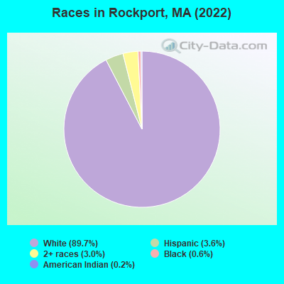
Ancestries: Irish (14.3%), English (13.3%), Italian (10.7%), American (7.9%), European (6.7%), Scottish (5.5%).
Current Local Time: EST time zone
Incorporated in 1840
Elevation: 77 feet
Land area: 4.00 square miles.
Population density: 1,243 people per square mile (low).
169 residents are foreign born (1.3% Europe, 0.9% Latin America, 0.6% North America, 0.5% Asia).
This place:
3.4%
Massachusetts:
17.6%
Median real estate property taxes paid for housing units with mortgages in 2022: $5,422 (0.8%) Median real estate property taxes paid for housing units with no mortgage in 2022: $6,150 (0.8%)
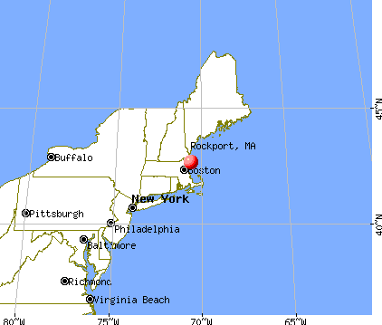
Nearest city with pop. 50,000+: Lynn, MA (21.3 miles , pop. 89,050).
Nearest city with pop. 200,000+: Boston, MA (33.3 miles , pop. 589,141).
Nearest city with pop. 1,000,000+: Bronx, NY (209.4 miles , pop. 1,332,650).
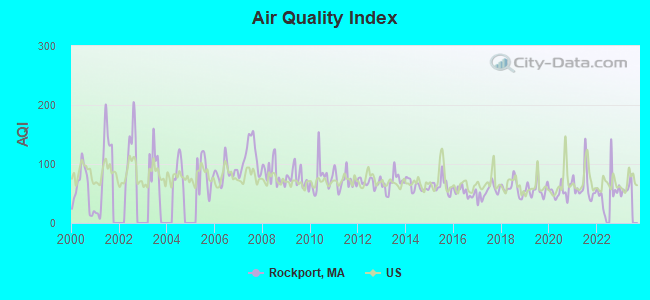
Air Quality Index (AQI) level in 2022 was 54.9. This is better than average.
City:
54.9
U.S.:
72.6
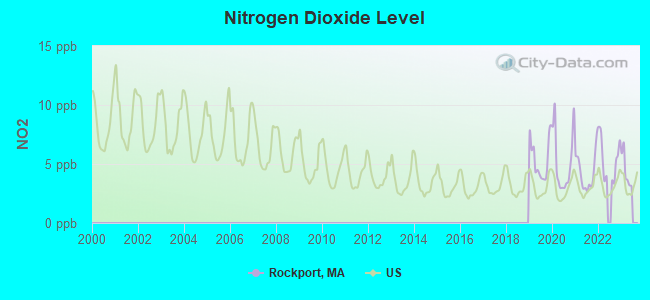
Nitrogen Dioxide (NO2) [ppb] level in 2022 was 5.41. This is about average.Closest monitor was 16.4 miles away from the city center.
City:
5.41
U.S.:
5.11
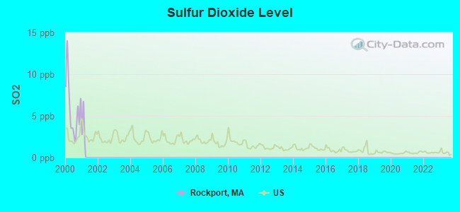
Sulfur Dioxide (SO2) [ppb] level in 2000 was 5.88. This is significantly worse than average.Closest monitor was 11.2 miles away from the city center.
City:
5.88
U.S.:
1.51
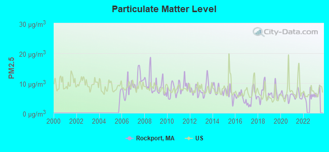
Particulate Matter (PM2.5) [µg/m3] level in 2022 was 5.69. This is significantly better than average.Closest monitor was 21.9 miles away from the city center.
City:
5.69
U.S.:
8.11
Tornado activity:
Rockport-area historical tornado activity is below Massachusetts state average. It is 61% smaller than the overall U.S. average.
On 6/9/1953, a category F3 (max. wind speeds 158-206 mph) tornado 28.3 miles away from the Rockport place center injured 5 peopleand causedbetween $5000 and $50,000 in damages.
On 9/29/1974, a category F3 tornado 29.8 miles away from the place center injured one personand causedbetween $50,000 and $500,000 in damages.
Earthquake activity:
Rockport-area historical earthquake activity is significantly above Massachusetts state average. It is 74% smaller than the overall U.S. average.
On 10/16/2012 at 23:12:25, a magnitude 4.7 (4.7 ML, Depth: 10.0 mi, Class: Light, Intensity: IV - V) earthquake occurred 65.3 miles away from Rockport center On 4/20/2002 at 10:50:47, a magnitude 5.3 (5.3 ML, Depth: 3.0 mi, Class: Moderate, Intensity: VI - VII) earthquake occurred 200.9 miles away from the city center On 1/19/1982 at 00:14:42, a magnitude 4.7 (4.5 MB, 4.7 MD, 4.5 LG) earthquake occurred 76.8 miles away from the city center On 10/7/1983 at 10:18:46, a magnitude 5.3 (5.1 MB, 5.3 LG, 5.1 ML) earthquake occurred 208.0 miles away from Rockport center On 4/20/2002 at 10:50:47, a magnitude 5.2 (5.2 MB, 4.2 MS, 5.2 MW, 5.0 MW) earthquake occurred 200.6 miles away from Rockport center On 8/22/1992 at 12:20:32, a magnitude 4.8 (4.8 MB, 3.8 MS, 4.7 LG, Depth: 6.2 mi) earthquake occurred 245.9 miles away from Rockport center Magnitude types: regional Lg-wave magnitude (LG), body-wave magnitude (MB), duration magnitude (MD), local magnitude (ML), surface-wave magnitude (MS), moment magnitude (MW)
Natural disasters:
The number of natural disasters in Essex County (33) is a lot greater than the US average (15). Major Disasters (Presidential) Declared: 20 Emergencies Declared: 13
Causes of natural disasters: Floods: 14, Storms: 11, Hurricanes: 6, Snowstorms: 5, Winter Storms: 5, Snows: 3, Blizzards: 2, Fire: 1, Heavy Rain: 1, Snowfall: 1, Water Main Break: 1, Wind: 1 (Note: some incidents may be assigned to more than one category).
Hospitals and medical centers in Rockport:
DEN MAR NH (44 SOUTH ST)
DEN-MAR NURSING HOME (44 SOUTH ST)
KINDRED NURSING AND REHABILITATION-DEN-MAR (44 SOUTH STREET)
ROCKPORT PUBLIC LIBRARY (Operating income: $476,781; Location: 17 SCHOOL STREET; 49,383 books; 4,275 audio materials; 4,099 video materials; 6 local licensed databases; 34 state licensed databases; 3 other licensed databases; 194 print serial subscriptions; 6 electronic serial subscriptions)
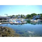
Notable locations in Rockport: Rockport Golf Club (A), Sandy Bay Historical Society (B), Rockport Information Center (C), Rockport Art Association (D), Rockport Fire Department Main Station (E). Display/hide their locations on the map
Churches in Rockport include: First United Church of Christ Congregational (A), First Unitarian Universalist Church (B). Display/hide their locations on the map
Tourist attraction: Babson Historical Association Inc (Museums; Beaver Dam).
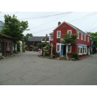
Hotels: Peg Leg Motel (10 Beach Street), Eden Pines Inn (48 Eden Road), Beach Knoll Inn (30 Beach Street), Peg Leg Inn (2 King Street), Getaway Inns Inc (51 Marmion Way), Captain Bounty Motor Inn (1 Beach Street), Bearskin Neck Motor Lodge (64 Bearskin Neck), Eagle House Motel (8 Cleaves St), Addison Choate Inn (49 Broadway).
Birthplace of: Vermin Supreme - Performance artist, Andrew Stanton - Animator, Rick Hautala - Horror writer, Frederick H. Tarr - Politician.
Essex County has a predicted average indoor radon screening level greater than 4 pCi/L (pico curies per liter) - Highest Potential
Drinking water stations with addresses in Rockport and their reported violations in the past:
ROCKPORT WATER DEPT (Population served: 9,871, Surface water):
Past monitoring violations:
Treatment Technique Precursor Removal - Between OCT-2005 and DEC-2005, Contaminant: CARBON, TOTAL. Follow-up actions: St AO (w/o penalty) issued (MAY-16-2006)
One routine major monitoring violation
Average household size:
This place:
2.1 people
Massachusetts:
2.5 people
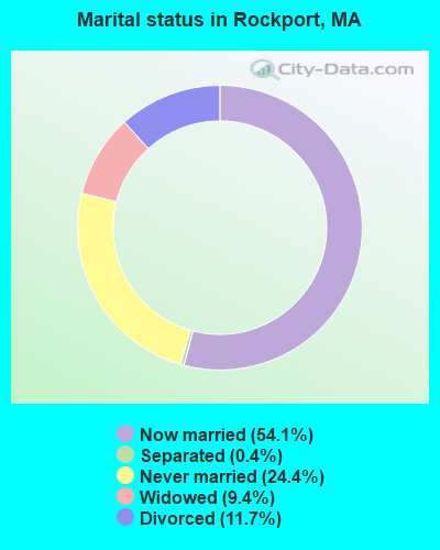
Percentage of family households:
This place:
56.0%
Whole state:
63.0%
Percentage of households with unmarried partners:
This place:
4.8%
Whole state:
7.0%
Likely homosexual households (counted as self-reported same-sex unmarried-partner households)
Lesbian couples: 0.8% of all households
Gay men: 0.6% of all households
69 people in nursing facilities/skilled-nursing facilities in 2010
78 people in nursing homes in 2000
Banks with branches in Rockport (2011 data):
The Rockport National Bank: School Street Branch, King Street Branch, at 16 Main Street. Info updated 2006/11/03: Bank assets: $178.8 mil, Deposits: $160.2 mil, local headquarters, positive income, Commercial Lending Specialization, 5 total offices, Holding Company: Rockport National Bancorp, Inc.
Granite Savings Bank: at 247 Main Street, branch established on 1884/03/21. Info updated 2009/07/07: Bank assets: $74.2 mil, Deposits: $59.5 mil, local headquarters, positive income, 1 total offices
Religion statistics for Rockport, MA (based on Essex County data)
Religion
Adherents
Congregations
Catholic
341,970
55
Mainline Protestant
33,710
140
Evangelical Protestant
20,925
160
Other
15,882
63
Orthodox
11,590
13
Black Protestant
376
3
None
318,706
-
Source: Clifford Grammich, Kirk Hadaway, Richard Houseal, Dale E.Jones, Alexei Krindatch, Richie Stanley and Richard H.Taylor. 2012. 2010 U.S.Religion Census: Religious Congregations & Membership Study. Association of Statisticians of American Religious Bodies. Jones, Dale E., et al. 2002. Congregations and Membership in the United States 2000. Nashville, TN: Glenmary Research Center. Graphs represent county-level data
Aircraft: PIPER PA-28-140 (Category: Land, Seats: 4, Weight: Up to 12,499 Pounds, Speed: 107 mph), Engine: LYCOMING 0-320 SERIES (180 HP) (Reciprocating) N-Number: 6963W, N6963W, N-6963W, Serial Number: 28-21158, Year manufactured: 1965, Airworthiness Date: 09/29/1965, Certificate Issue Date: 02/27/2019 Registrant (Individual): Larry A Nash, 23a Granite St, Rockport, MA 01966
Aircraft: PIPER PA-18 (Category: Land, Seats: 2, Weight: Up to 12,499 Pounds, Speed: 97 mph), Engine: CONT MOTOR C90 SERIES (95 HP) (Reciprocating) N-Number: 8082D, N8082D, N-8082D, Serial Number: 18-6073, Year manufactured: 1957, Airworthiness Date: 09/10/1957, Certificate Issue Date: 08/31/2006 Registrant (Co-Owned): Richard L York, 35 King St, Rockport, MA 01966, Other Owners: Thomas E Budrow
Aircraft: HARNISH RONALD A RV-10 (Category: Land, Seats: 4, Weight: Up to 12,499 Pounds), Engine: Reciprocating N-Number: 910H, N910H, N-910H, Serial Number: 40687, Year manufactured: 2008, Certificate Issue Date: 01/15/2008 Registrant (Individual): Ronald A Harnish, 10 Seagull St, Rockport, MA 01966
Aircraft: DJI PHANTOM 2 VISION (Category: Land, Engines: 4), Engine: Electric N-Number: 228BD, N228BD, N-228BD, Serial Number: BC 221005441320, Certificate Issue Date: 03/21/2016 Registrant (Individual): Vincent Jr Nappa, 5 S Street Ct, Rockport, MA 01966 Deregistered:Cancel Date: 09/06/2019
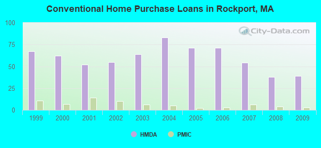
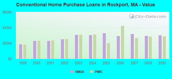
Home Mortgage Disclosure Act Aggregated Statistics For Year 2009 (Based on 1 partial tract)
A) FHA, FSA/RHS & VA Home Purchase Loans
B) Conventional Home Purchase Loans
C) Refinancings
D) Home Improvement Loans
E) Loans on Dwellings For 5+ Families
F) Non-occupant Loans on < 5 Family Dwellings (A B C & D)
Number
Average Value
Number
Average Value
Number
Average Value
Number
Average Value
Number
Average Value
Number
Average Value
LOANS ORIGINATED
4
$283,100
39
$306,184
159
$285,440
17
$259,986
1
$464,280
48
$321,366
APPLICATIONS APPROVED, NOT ACCEPTED
0
$0
1
$156,270
10
$299,690
1
$4,530
0
$0
3
$265,927
APPLICATIONS DENIED
2
$322,450
3
$250,827
40
$353,974
6
$95,877
0
$0
7
$367,544
APPLICATIONS WITHDRAWN
2
$233,840
5
$177,786
24
$321,649
0
$0
0
$0
4
$242,192
FILES CLOSED FOR INCOMPLETENESS
0
$0
2
$323,865
6
$333,303
1
$28,310
0
$0
2
$385,015
Aggregated Statistics For Year 2008 (Based on 1 partial tract)
A) FHA, FSA/RHS & VA Home Purchase Loans
B) Conventional Home Purchase Loans
C) Refinancings
D) Home Improvement Loans
E) Loans on Dwellings For 5+ Families
F) Non-occupant Loans on < 5 Family Dwellings (A B C & D)
Number
Average Value
Number
Average Value
Number
Average Value
Number
Average Value
Number
Average Value
Number
Average Value
LOANS ORIGINATED
2
$270,645
38
$299,892
69
$284,364
20
$253,828
1
$336,890
29
$271,171
APPLICATIONS APPROVED, NOT ACCEPTED
0
$0
5
$283,892
9
$294,424
2
$92,005
0
$0
4
$284,090
APPLICATIONS DENIED
0
$0
5
$239,276
18
$295,179
4
$199,445
0
$0
3
$297,253
APPLICATIONS WITHDRAWN
0
$0
5
$212,778
16
$299,768
0
$0
0
$0
3
$200,057
FILES CLOSED FOR INCOMPLETENESS
0
$0
1
$130,790
3
$188,543
1
$22,650
0
$0
1
$143,810
Aggregated Statistics For Year 2007 (Based on 1 partial tract)
B) Conventional Home Purchase Loans
C) Refinancings
D) Home Improvement Loans
E) Loans on Dwellings For 5+ Families
F) Non-occupant Loans on < 5 Family Dwellings (A B C & D)
Number
Average Value
Number
Average Value
Number
Average Value
Number
Average Value
Number
Average Value
LOANS ORIGINATED
54
$321,937
79
$282,742
26
$173,671
1
$226,480
33
$314,035
APPLICATIONS APPROVED, NOT ACCEPTED
11
$250,621
16
$284,799
2
$50,390
0
$0
5
$339,268
APPLICATIONS DENIED
7
$369,567
39
$297,603
9
$145,828
0
$0
5
$335,078
APPLICATIONS WITHDRAWN
8
$376,099
17
$259,986
2
$263,285
0
$0
5
$254,790
FILES CLOSED FOR INCOMPLETENESS
1
$260,450
7
$284,556
2
$265,550
0
$0
0
$0
Aggregated Statistics For Year 2006 (Based on 1 partial tract)
B) Conventional Home Purchase Loans
C) Refinancings
D) Home Improvement Loans
F) Non-occupant Loans on < 5 Family Dwellings (A B C & D)
G) Loans On Manufactured Home Dwelling (A B C & D)
Number
Average Value
Number
Average Value
Number
Average Value
Number
Average Value
Number
Average Value
LOANS ORIGINATED
71
$295,341
106
$264,453
35
$134,351
39
$303,730
0
$0
APPLICATIONS APPROVED, NOT ACCEPTED
7
$308,336
15
$317,147
5
$106,672
3
$248,183
1
$130,230
APPLICATIONS DENIED
6
$348,118
39
$264,953
7
$145,917
5
$337,228
0
$0
APPLICATIONS WITHDRAWN
5
$279,930
29
$284,740
3
$243,090
5
$284,912
0
$0
FILES CLOSED FOR INCOMPLETENESS
2
$175,240
3
$344,627
1
$232,140
1
$178,350
0
$0
Aggregated Statistics For Year 2005 (Based on 1 partial tract)
A) FHA, FSA/RHS & VA Home Purchase Loans
B) Conventional Home Purchase Loans
C) Refinancings
D) Home Improvement Loans
E) Loans on Dwellings For 5+ Families
F) Non-occupant Loans on < 5 Family Dwellings (A B C & D)
Number
Average Value
Number
Average Value
Number
Average Value
Number
Average Value
Number
Average Value
Number
Average Value
LOANS ORIGINATED
1
$190,240
71
$331,610
142
$288,040
20
$222,772
1
$339,720
24
$335,285
APPLICATIONS APPROVED, NOT ACCEPTED
0
$0
8
$306,244
16
$278,924
1
$145,510
0
$0
6
$342,268
APPLICATIONS DENIED
0
$0
12
$269,181
40
$311,311
10
$77,116
0
$0
3
$311,410
APPLICATIONS WITHDRAWN
1
$198,170
10
$283,666
33
$230,718
5
$179,826
0
$0
3
$329,717
FILES CLOSED FOR INCOMPLETENESS
0
$0
2
$313,110
14
$318,124
1
$8,490
0
$0
1
$118,900
Aggregated Statistics For Year 2004 (Based on 1 partial tract)
A) FHA, FSA/RHS & VA Home Purchase Loans
B) Conventional Home Purchase Loans
C) Refinancings
D) Home Improvement Loans
E) Loans on Dwellings For 5+ Families
F) Non-occupant Loans on < 5 Family Dwellings (A B C & D)
G) Loans On Manufactured Home Dwelling (A B C & D)
Number
Average Value
Number
Average Value
Number
Average Value
Number
Average Value
Number
Average Value
Number
Average Value
Number
Average Value
LOANS ORIGINATED
1
$109,840
83
$306,949
132
$259,530
15
$150,269
2
$314,240
40
$293,943
1
$24,350
APPLICATIONS APPROVED, NOT ACCEPTED
0
$0
9
$403,260
9
$300,149
2
$203,550
1
$268,940
3
$414,837
0
$0
APPLICATIONS DENIED
1
$92,860
10
$254,677
24
$293,221
3
$56,053
0
$0
3
$219,873
1
$24,910
APPLICATIONS WITHDRAWN
0
$0
13
$279,180
29
$226,539
2
$161,365
0
$0
6
$243,655
0
$0
FILES CLOSED FOR INCOMPLETENESS
0
$0
1
$303,480
19
$279,256
1
$297,820
0
$0
0
$0
0
$0
Aggregated Statistics For Year 2003 (Based on 1 partial tract)
B) Conventional Home Purchase Loans
C) Refinancings
D) Home Improvement Loans
E) Loans on Dwellings For 5+ Families
F) Non-occupant Loans on < 5 Family Dwellings (A B C & D)
Number
Average Value
Number
Average Value
Number
Average Value
Number
Average Value
Number
Average Value
LOANS ORIGINATED
64
$310,738
404
$218,433
10
$92,064
3
$1,005,950
59
$266,018
APPLICATIONS APPROVED, NOT ACCEPTED
7
$306,396
31
$208,416
2
$26,045
0
$0
3
$299,897
APPLICATIONS DENIED
6
$506,277
54
$255,859
4
$65,820
0
$0
6
$253,280
APPLICATIONS WITHDRAWN
10
$257,168
42
$262,124
2
$48,410
0
$0
5
$251,054
FILES CLOSED FOR INCOMPLETENESS
0
$0
4
$201,850
0
$0
0
$0
0
$0
Aggregated Statistics For Year 2002 (Based on 1 partial tract)
A) FHA, FSA/RHS & VA Home Purchase Loans
B) Conventional Home Purchase Loans
C) Refinancings
D) Home Improvement Loans
E) Loans on Dwellings For 5+ Families
F) Non-occupant Loans on < 5 Family Dwellings (A B C & D)
Number
Average Value
Number
Average Value
Number
Average Value
Number
Average Value
Number
Average Value
Number
Average Value
LOANS ORIGINATED
1
$410,490
55
$255,397
264
$213,365
15
$112,636
1
$385,580
33
$255,047
APPLICATIONS APPROVED, NOT ACCEPTED
1
$124,560
7
$322,006
22
$204,475
3
$37,747
0
$0
1
$418,990
APPLICATIONS DENIED
0
$0
5
$213,570
27
$266,491
6
$48,410
0
$0
2
$144,945
APPLICATIONS WITHDRAWN
0
$0
6
$351,327
35
$227,353
2
$58,600
0
$0
3
$336,700
FILES CLOSED FOR INCOMPLETENESS
0
$0
1
$92,860
6
$221,385
0
$0
0
$0
1
$118,900
Aggregated Statistics For Year 2001 (Based on 1 partial tract)
A) FHA, FSA/RHS & VA Home Purchase Loans
B) Conventional Home Purchase Loans
C) Refinancings
D) Home Improvement Loans
E) Loans on Dwellings For 5+ Families
F) Non-occupant Loans on < 5 Family Dwellings (A B C & D)
Number
Average Value
Number
Average Value
Number
Average Value
Number
Average Value
Number
Average Value
Number
Average Value
LOANS ORIGINATED
2
$201,565
52
$235,539
210
$200,168
11
$65,679
2
$211,195
26
$205,357
APPLICATIONS APPROVED, NOT ACCEPTED
0
$0
6
$245,448
17
$192,475
2
$49,540
1
$116,070
2
$234,125
APPLICATIONS DENIED
0
$0
4
$185,148
30
$202,737
5
$68,284
0
$0
2
$201,285
APPLICATIONS WITHDRAWN
0
$0
9
$243,780
29
$185,928
5
$41,332
0
$0
3
$190,997
FILES CLOSED FOR INCOMPLETENESS
0
$0
1
$441,640
3
$125,507
1
$42,460
0
$0
1
$56,620
Aggregated Statistics For Year 2000 (Based on 1 partial tract)
A) FHA, FSA/RHS & VA Home Purchase Loans
B) Conventional Home Purchase Loans
C) Refinancings
D) Home Improvement Loans
E) Loans on Dwellings For 5+ Families
F) Non-occupant Loans on < 5 Family Dwellings (A B C & D)
Number
Average Value
Number
Average Value
Number
Average Value
Number
Average Value
Number
Average Value
Number
Average Value
LOANS ORIGINATED
1
$98,520
62
$233,831
45
$148,646
10
$39,634
1
$226,480
17
$251,859
APPLICATIONS APPROVED, NOT ACCEPTED
1
$100,780
8
$199,515
5
$107,692
3
$32,463
0
$0
1
$61,150
APPLICATIONS DENIED
1
$137,020
7
$233,031
12
$177,976
6
$33,500
0
$0
2
$162,215
APPLICATIONS WITHDRAWN
1
$123,430
4
$333,775
13
$129,791
3
$38,123
1
$138,720
1
$110,980
FILES CLOSED FOR INCOMPLETENESS
0
$0
2
$167,310
2
$179,770
1
$14,720
0
$0
0
$0
Aggregated Statistics For Year 1999 (Based on 1 partial tract)
A) FHA, FSA/RHS & VA Home Purchase Loans
B) Conventional Home Purchase Loans
C) Refinancings
D) Home Improvement Loans
E) Loans on Dwellings For 5+ Families
F) Non-occupant Loans on < 5 Family Dwellings (A B C & D)
Detailed PMIC statistics for the following Tracts:2201.00
2002 - 2018 National Fire Incident Reporting System (NFIRS) incidents
According to the data from the years 2002 - 2018 the average number of fire incidents per year is 10. The highest number of fires - 24 took place in 2005, and the least - 0 in 2004. The data has a rising trend.
When looking into fire subcategories, the most reports belonged to: Structure Fires (46.2%), and Outside Fires (31.0%).
Fire incident types reported to NFIRS in Rockport, MA


 Recent articles from our blog. Our writers, many of them Ph.D. graduates or candidates, create easy-to-read articles on a wide variety of topics.

 (21.3 miles
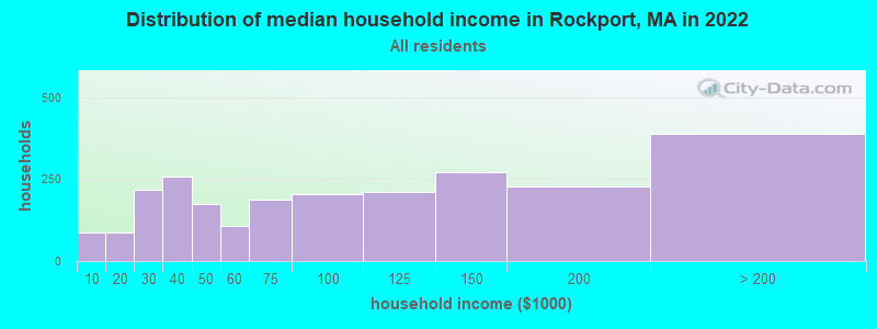


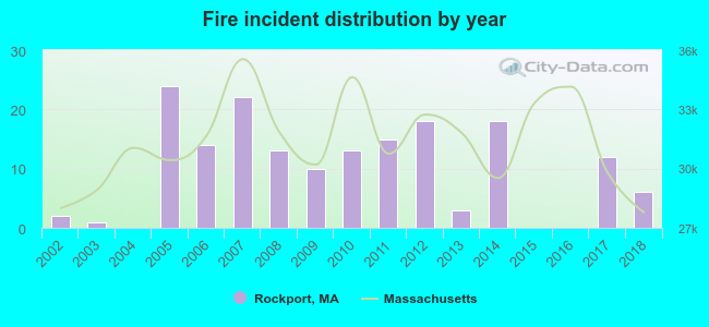 According to the data from the years 2002 - 2018 the average number of fire incidents per year is 10. The highest number of fires - 24 took place in 2005, and the least - 0 in 2004. The data has a rising trend.
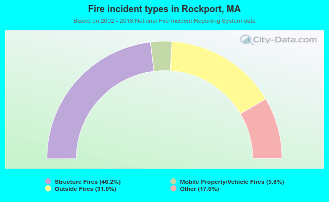 When looking into fire subcategories, the most reports belonged to: Structure Fires (46.2%), and Outside Fires (31.0%).