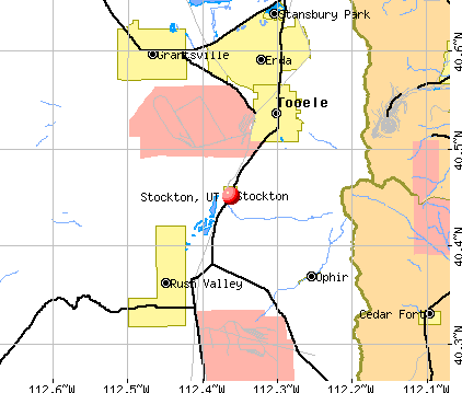
Stockton, Utah
Submit your own pictures of this town and show them to the world
- OSM Map
- General Map
- Google Map
- MSN Map
Population change since 2000: +40.6%
| Males: 268 | |
| Females: 355 |
| Median resident age: | 41.4 years |
| Utah median age: | 32.1 years |
Zip codes: 84071.
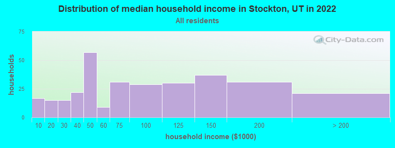
| Stockton: | $75,173 |
| UT: | $89,168 |
Estimated per capita income in 2022: $35,525 (it was $15,894 in 2000)
Stockton town income, earnings, and wages data
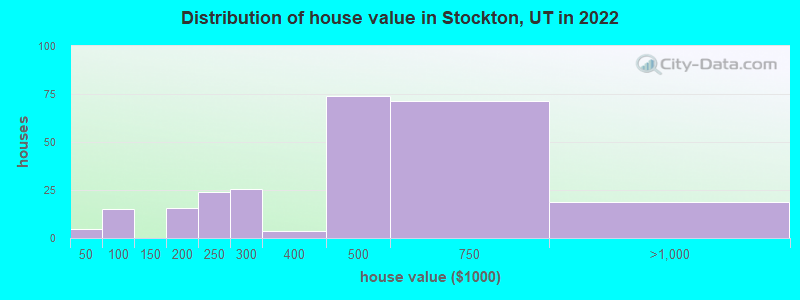
Estimated median house or condo value in 2022: $386,079 (it was $93,300 in 2000)
| Stockton: | $386,079 |
| UT: | $499,500 |
Mean prices in 2022: all housing units: $442,034; detached houses: $456,318; mobile homes: $231,297
Median gross rent in 2022: $721.
(6.9% for White Non-Hispanic residents, 36.8% for Hispanic or Latino residents, 14.3% for two or more races residents)
Detailed information about poverty and poor residents in Stockton, UT
Compare current foreclosures near Stockton, UT:
| Photo | Address | Area | Beds / Baths | Price | Details |
|---|---|---|---|---|---|

|
#1
N Flat Top Dr
Tooele, UT 84074
|
- sq. feet
|
2 baths 4 beds |
show details | |

|
#2
Long Ridge Dr
Herriman, UT 84096
|
2,307 sq. feet
|
2 baths 3 beds |
show details | |

|
#3
W Hi Country Rd
Herriman, UT 84096
|
2,302 sq. feet
|
3 baths 3 beds |
show details | |

|
#4
S Lamont Lowell Cir
Herriman, UT 84096
|
3,748 sq. feet
|
3 baths 4 beds |
show details | |

|
#5
S Rosie Ln
Herriman, UT 84096
|
3,742 sq. feet
|
2 baths 4 beds |
show details | |

|
#6
W Park St
Bingham Canyon, UT 84006
|
938 sq. feet
|
1 baths 2 beds |
show details | |

|
#7
W Windy Ridge Dr
Herriman, UT 84096
|
4,554 sq. feet
|
6 baths 5 beds |
show details | |

|
#8
W 500 S
Tooele, UT 84074
|
1,056 sq. feet
|
- baths - beds |
show details | |

|
#9
E Colettest Lake Point
Tooele, UT 84074
|
- sq. feet
|
- baths - beds |
show details | |

|
#10
E Sunset View Rd
Grantsville, UT 84029
|
- sq. feet
|
- baths - beds |
show details |
| Photo | Address | Area | Beds / Baths | Price | Details |
|---|---|---|---|---|---|

|
#11
Gold Dust Rd
Grantsville, UT 84029
|
- sq. feet
|
- baths - beds |
show details | |

|
#12
E Clover Gate Ln
Grantsville, UT 84029
|
- sq. feet
|
- baths - beds |
show details | |

|
#13
Rodeo Dr
Grantsville, UT 84029
|
- sq. feet
|
- baths - beds |
show details | |

|
#14
N 210 E
Tooele, UT 84074
|
- sq. feet
|
- baths - beds |
show details | |

|
#15
S Virginia Ln
Grantsville, UT 84029
|
- sq. feet
|
- baths - beds |
show details | |

|
#16
S Tawny Dr
Grantsville, UT 84029
|
- sq. feet
|
- baths - beds |
show details | |

|
#17
S Woodruff Way
Grantsville, UT 84029
|
- sq. feet
|
- baths - beds |
show details | |

|
#18
S Mustang Ridge Rd
Grantsville, UT 84029
|
- sq. feet
|
- baths - beds |
show details | |

|
#19
S Jodi Ln
Grantsville, UT 84029
|
- sq. feet
|
- baths - beds |
show details | |

|
#20
S Eyring Pl
Grantsville, UT 84029
|
- sq. feet
|
- baths - beds |
show details |
| Photo | Address | Area | Beds / Baths | Price | Details |
|---|---|---|---|---|---|

|
#21
W 2200 N
Tooele, UT 84074
|
- sq. feet
|
- baths - beds |
show details | |

|
#22
N Berra Blvd Apt E302
Tooele, UT 84074
|
- sq. feet
|
- baths - beds |
show details | |

|
#23
Aparicio Dr
Tooele, UT 84074
|
- sq. feet
|
- baths - beds |
show details | |

|
#24
N Berra Blvd Apt H103
Tooele, UT 84074
|
- sq. feet
|
- baths - beds |
show details | |

|
#25
N 180 E # D062
Tooele, UT 84074
|
- sq. feet
|
- baths - beds |
show details | |

|
#26
E Main St Trlr 28
Grantsville, UT 84029
|
- sq. feet
|
- baths - beds |
show details | |

|
#27
W 1960 N
Tooele, UT 84074
|
- sq. feet
|
- baths - beds |
show details | |

|
#28
Walden Dr
Tooele, UT 84074
|
- sq. feet
|
- baths - beds |
show details | |

|
#29
Drysdale Way
Tooele, UT 84074
|
- sq. feet
|
- baths - beds |
show details | |

|
#30
E Oliver Rd
Tooele, UT 84074
|
- sq. feet
|
- baths - beds |
show details |
| Photo | Address | Area | Beds / Baths | Price | Details |
|---|---|---|---|---|---|

|
#31
Reddington Ln Apt 128
Tooele, UT 84074
|
- sq. feet
|
- baths - beds |
show details | |

|
#32
W 1410 N, Noth
Tooele, UT 84074
|
- sq. feet
|
- baths - beds |
show details | |

|
#33
W 1360 N
Tooele, UT 84074
|
- sq. feet
|
- baths - beds |
show details | |

|
#34
W 1360 N
Tooele, UT 84074
|
- sq. feet
|
- baths - beds |
show details | |

|
#35
N Brook Ave
Tooele, UT 84074
|
- sq. feet
|
- baths - beds |
show details | |

|
#36
N 100 E, Apt 121
Tooele, UT 84074
|
- sq. feet
|
- baths - beds |
show details | |

|
#37
S Mustang Ridge Rd
Grantsville, UT 84029
|
- sq. feet
|
- baths - beds |
show details | |

|
#38
E Clark St
Grantsville, UT 84029
|
- sq. feet
|
- baths - beds |
show details | |

|
#39
E Main St Trlr 27
Grantsville, UT 84029
|
- sq. feet
|
- baths - beds |
show details | |

|
#40
E Angell Way
Tooele, UT 84074
|
- sq. feet
|
- baths - beds |
show details |
| Photo | Address | Area | Beds / Baths | Price | Details |
|---|---|---|---|---|---|

|
#41
S Sheps Ridge Ln
Herriman, UT 84096
|
- sq. feet
|
- baths - beds |
show details | |

|
#42
W Hollister Way
Herriman, UT 84096
|
- sq. feet
|
- baths - beds |
show details | |

|
#43
Shepherd Rd
Tooele, UT 84074
|
- sq. feet
|
- baths - beds |
show details | |

|
#44
W Sharlie Dawn Cir
Herriman, UT 84096
|
- sq. feet
|
- baths - beds |
show details | |

|
#45
Columbine Ln
Dugway, UT 84022
|
- sq. feet
|
- baths - beds |
show details | |

|
#46
W Desert Lily Cir
Herriman, UT 84096
|
- sq. feet
|
- baths - beds |
show details | |

|
#47
N Round Rock Rd
Tooele, UT 84074
|
- sq. feet
|
- baths - beds |
show details | |

|
#48
W Vista Springs Dr
Herriman, UT 84096
|
- sq. feet
|
- baths - beds |
show details | |

|
#49
S Copperton Cir
Bingham Canyon, UT 84006
|
- sq. feet
|
- baths - beds |
show details | |

|
Check over 1 million property listings on Foreclosure.com!
|
browse all offers | |||


- 93995.1%White alone
- 222.2%Hispanic
- 60.6%American Indian alone
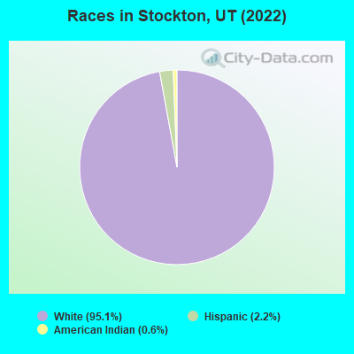
Races in Stockton detailed stats: ancestries, foreign born residents, place of birth
According to our research of Utah and other state lists, there were 7 registered sex offenders living in Stockton, Utah as of April 26, 2024.
The ratio of all residents to sex offenders in Stockton is 107 to 1.
 Recent articles from our blog. Our writers, many of them Ph.D. graduates or candidates, create easy-to-read articles on a wide variety of topics.

 | Relocating to SLC - is it really that bad there? (46 replies) |
| SLC quality of life on the decline? (75 replies) |
| Any rural housing? (5 replies) |
| Rural areas outside of Salt Lake (9 replies) |
| Air Quality/Inversions (851 replies) |
| Is Salt Lake City really more dangerous than Los Angeles? (50 replies) |
Latest news from Stockton, UT collected exclusively by city-data.com from local newspapers, TV, and radio stations
Ancestries: English (60.1%), Irish (22.2%), German (5.2%), American (4.0%), Scotch-Irish (3.0%).
Current Local Time: MST time zone
Elevation: 5068 feet
Land area: 0.94 square miles.
Population density: 659 people per square mile (low).
2 residents are foreign born
| This town: | 0.5% |
| Utah: | 7.1% |
Median real estate property taxes paid for housing units with mortgages in 2022: $2,616 (0.8%)
Median real estate property taxes paid for housing units with no mortgage in 2022: $4,257 (0.7%)
Nearest city with pop. 50,000+: West Jordan, UT  (23.0 miles , pop. 68,336).
Nearest city with pop. 200,000+: Las Vegas, NV (332.8 miles , pop. 478,434).
Nearest city with pop. 1,000,000+: Phoenix, AZ (479.1 miles , pop. 1,321,045).
Nearest cities:
), ), ), )Latitude: 40.45 N, Longitude: 112.36 W
Area code commonly used in this area: 435

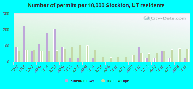
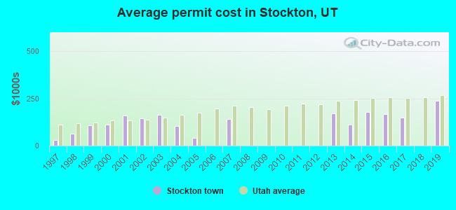
Single-family new house construction building permits:
- 2019: 1 building, cost: $236,500
- 2017: 1 building, cost: $150,000
- 2016: 3 buildings, average cost: $167,500
- 2015: 1 building, cost: $178,900
- 2014: 1 building, cost: $110,000
- 2013: 4 buildings, average cost: $171,100
- 2007: 1 building, cost: $140,000
- 2005: 1 building, cost: $40,000
- 2004: 1 building, cost: $101,700
- 2003: 4 buildings, average cost: $162,500
- 2002: 9 buildings, average cost: $145,300
- 2001: 8 buildings, average cost: $158,400
- 2000: 5 buildings, average cost: $111,900
- 1999: 3 buildings, average cost: $108,300
- 1998: 10 buildings, average cost: $63,500
- 1997: 4 buildings, average cost: $27,500
| Here: | 2.7% |
| Utah: | 2.5% |
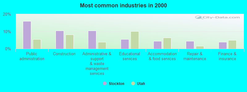
- Public administration (15.8%)
- Construction (10.4%)
- Administrative & support & waste management services (10.4%)
- Educational services (5.4%)
- Accommodation & food services (4.5%)
- Repair & maintenance (4.5%)
- Finance & insurance (4.0%)

- Public administration (19.4%)
- Construction (14.5%)
- Administrative & support & waste management services (12.1%)
- Repair & maintenance (5.6%)
- Metal & metal products (4.8%)
- Mining, quarrying, oil & gas extraction (4.0%)
- Food & beverage stores (4.0%)
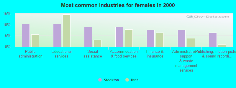
- Public administration (10.3%)
- Educational services (10.3%)
- Social assistance (9.0%)
- Accommodation & food services (9.0%)
- Finance & insurance (7.7%)
- Administrative & support & waste management services (7.7%)
- Publishing, motion picture & sound recording industries (6.4%)
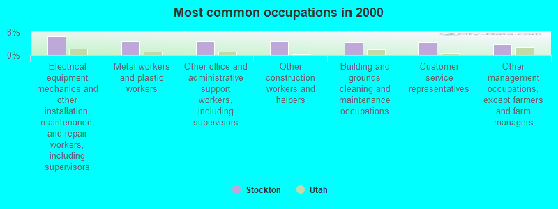
- Electrical equipment mechanics and other installation, maintenance, and repair workers, including supervisors (6.4%)
- Metal workers and plastic workers (5.0%)
- Other office and administrative support workers, including supervisors (5.0%)
- Other construction workers and helpers (5.0%)
- Building and grounds cleaning and maintenance occupations (4.5%)
- Customer service representatives (4.5%)
- Other management occupations, except farmers and farm managers (4.0%)
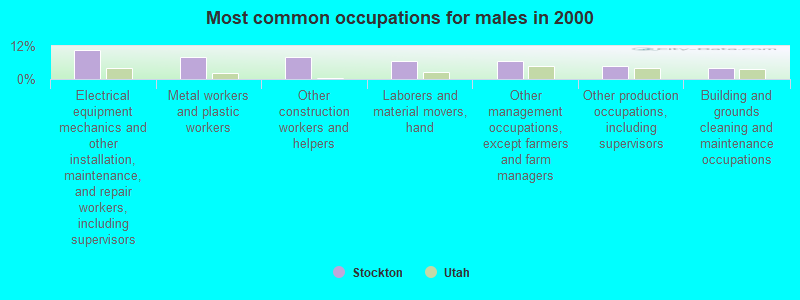
- Electrical equipment mechanics and other installation, maintenance, and repair workers, including supervisors (10.5%)
- Metal workers and plastic workers (8.1%)
- Other construction workers and helpers (8.1%)
- Laborers and material movers, hand (6.5%)
- Other management occupations, except farmers and farm managers (6.5%)
- Other production occupations, including supervisors (4.8%)
- Building and grounds cleaning and maintenance occupations (4.0%)
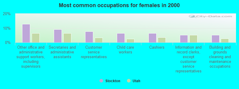
- Other office and administrative support workers, including supervisors (12.8%)
- Secretaries and administrative assistants (9.0%)
- Customer service representatives (7.7%)
- Child care workers (6.4%)
- Cashiers (6.4%)
- Information and record clerks, except customer service representatives (5.1%)
- Building and grounds cleaning and maintenance occupations (5.1%)
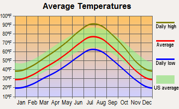
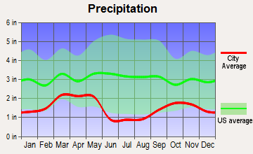
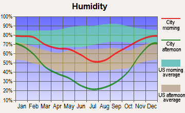
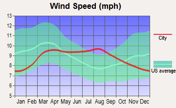
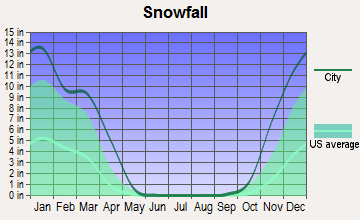
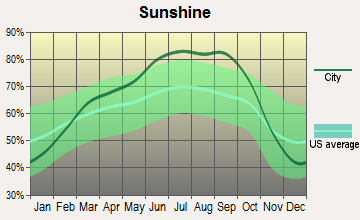
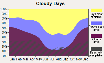
Average climate in Stockton, Utah
Based on data reported by over 4,000 weather stations
(lower is better)
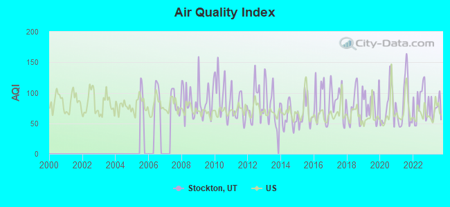
Air Quality Index (AQI) level in 2023 was 74.1. This is about average.
| City: | 74.1 |
| U.S.: | 72.6 |
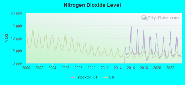
Nitrogen Dioxide (NO2) [ppb] level in 2023 was 4.06. This is better than average. Closest monitor was 17.4 miles away from the city center.
| City: | 4.06 |
| U.S.: | 5.11 |
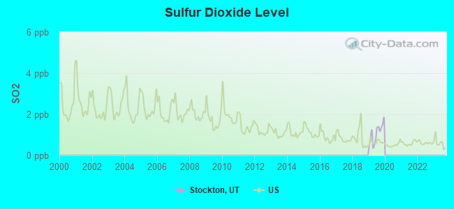
Sulfur Dioxide (SO2) [ppb] level in 2019 was 1.07. This is significantly better than average. Closest monitor was 7.3 miles away from the city center.
| City: | 1.07 |
| U.S.: | 1.51 |
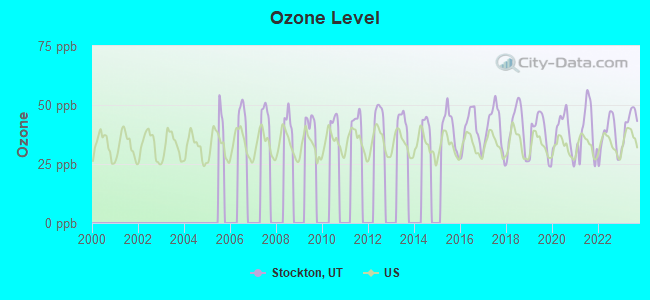
Ozone [ppb] level in 2023 was 42.8. This is worse than average. Closest monitor was 7.2 miles away from the city center.
| City: | 42.8 |
| U.S.: | 33.3 |
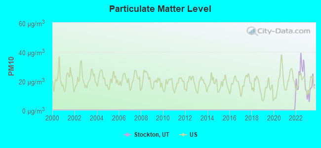
Particulate Matter (PM10) [µg/m3] level in 2023 was 14.5. This is better than average. Closest monitor was 11.5 miles away from the city center.
| City: | 14.5 |
| U.S.: | 19.2 |
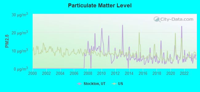
Particulate Matter (PM2.5) [µg/m3] level in 2023 was 5.72. This is significantly better than average. Closest monitor was 7.2 miles away from the city center.
| City: | 5.72 |
| U.S.: | 8.11 |
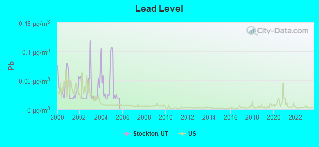
Lead (Pb) [µg/m3] level in 2005 was 0.0394. This is significantly worse than average. Closest monitor was 22.7 miles away from the city center.
| City: | 0.0394 |
| U.S.: | 0.0093 |
Earthquake activity:
Stockton-area historical earthquake activity is significantly above Utah state average. It is 2341% greater than the overall U.S. average.On 10/3/1915 at 06:52:48, a magnitude 7.6 (7.6 UK, Class: Major, Intensity: VIII - XII) earthquake occurred 270.3 miles away from Stockton center
On 8/18/1959 at 06:37:13, a magnitude 7.7 (7.7 UK) earthquake occurred 297.6 miles away from the city center, causing $26,000,000 total damage
On 10/28/1983 at 14:06:06, a magnitude 7.3 (6.2 MB, 7.3 MS, 7.0 MW) earthquake occurred 261.4 miles away from Stockton center, causing 2 deaths (2 shaking deaths) and 3 injuries, causing $15,000,000 total damage
On 3/28/1975 at 02:31:05, a magnitude 6.2 (6.1 MB, 6.0 MS, 6.2 ML, Class: Strong, Intensity: VII - IX) earthquake occurred 108.1 miles away from the city center
On 12/21/1932 at 06:10:09, a magnitude 7.2 (7.2 UK) earthquake occurred 333.6 miles away from the city center
On 12/16/1954 at 11:07:12, a magnitude 7.0 (7.0 UK) earthquake occurred 311.7 miles away from the city center
Magnitude types: body-wave magnitude (MB), local magnitude (ML), surface-wave magnitude (MS), moment magnitude (MW)
Natural disasters:
The number of natural disasters in Tooele County (7) is smaller than the US average (15).Major Disasters (Presidential) Declared: 4
Emergencies Declared: 2
Causes of natural disasters: Floods: 4, Landslides: 3, Storms: 2, Drought: 1, Hurricane: 1, Mudslide: 1, Other: 1 (Note: some incidents may be assigned to more than one category).

Hospitals and medical centers near Stockton:
- ROCKY MOUNTAIN CARE - TOOELE (Nursing Home, about 7 miles away; TOOELE, UT)
- TOOELE VALLEY NURSING HOME (Nursing Home, about 7 miles away; TOOLE, UT)
- MOUNTAIN WEST MEDICAL CENTER Acute Care Hospitals (about 9 miles away; TOOELE, UT)
- TOOELE VALLEY DIALYSIS CENTER (Dialysis Facility, about 9 miles away; TOOELE, UT)
Colleges/universities with over 2000 students nearest to Stockton:
- Salt Lake Community College (about 27 miles; Salt Lake City, UT; Full-time enrollment: 20,797)
- Stevens-Henager College-Murray (about 29 miles; Murray, UT; FT enrollment: 6,395)
- Western Governors University (about 31 miles; Salt Lake City, UT; FT enrollment: 31,481)
- Latter-day Saints Business College (about 33 miles; Salt Lake City, UT; FT enrollment: 2,059)
- Westminster College (about 33 miles; Salt Lake City, UT; FT enrollment: 2,870)
- University of Utah (about 35 miles; Salt Lake City, UT; FT enrollment: 28,454)
- Utah Valley University (about 37 miles; Orem, UT; FT enrollment: 24,403)
Points of interest:
Notable location: Stockton Fire Department (A). Display/hide its location on the map
Church in Stockton: The Church of Jesus Christ of Latter Day Saints (A). Display/hide its location on the map
Cemetery: Stockton Cemetery (1). Display/hide its location on the map
Drinking water stations with addresses in Stockton and their reported violations in the past:
STOCKTON TOWN WATER SYSTEM (Population served: 600, Surface water):Past monitoring violations:SOUTH RIM WATER SYSTEM (Population served: 264, Groundwater):
- 69 regular monitoring violations
Past health violations:Past monitoring violations:
- MCL, Monthly (TCR) - In SEP-2011, Contaminant: Coliform
- MCL, Monthly (TCR) - In SEP-2010, Contaminant: Coliform. Follow-up actions: St Formal NOV issued (NOV-06-2010), St Public Notif requested (NOV-06-2010)
- MCL, Monthly (TCR) - In JAN-2010, Contaminant: Coliform. Follow-up actions: St Public Notif requested (FEB-25-2010), St Formal NOV issued (FEB-25-2010), St Compliance achieved (JUN-30-2010)
- MCL, Monthly (TCR) - In NOV-2005, Contaminant: Coliform. Follow-up actions: St Public Notif requested (FEB-21-2006), St Violation/Reminder Notice (FEB-21-2006), St Compliance achieved (JAN-01-2008)
- MCL, Acute (TCR) - In JUL-2005, Contaminant: Coliform. Follow-up actions: St Violation/Reminder Notice (4 times from NOV-10-2005 to NOV-10-2005)
- Follow-up Or Routine LCR Tap M/R - In JAN-01-2006, Contaminant: Lead and Copper Rule. Follow-up actions: St Violation/Reminder Notice (FEB-15-2006), St Compliance achieved (FEB-15-2006), St Public Notif requested (FEB-15-2006), St Compliance achieved (3 times from JUL-07-2009 to MAY-02-2011)
| This town: | 2.9 people |
| Utah: | 3.1 people |
| This town: | 80.1% |
| Whole state: | 75.2% |
| This town: | 5.1% |
| Whole state: | 4.6% |
No gay or lesbian households reported
For population 15 years and over in Stockton:
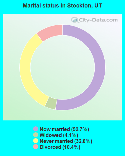
- Never married: 32.8%
- Now married: 52.7%
- Separated: 0.0%
- Widowed: 4.1%
- Divorced: 10.4%
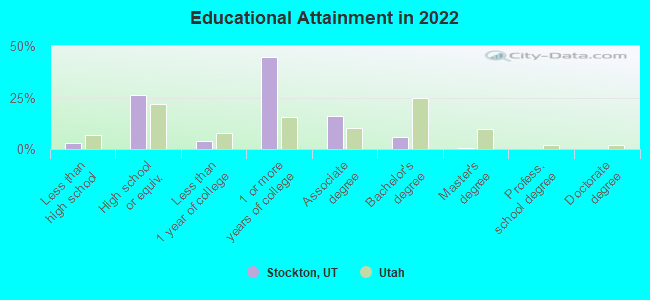
For population 25 years and over in Stockton:
- High school or higher: 96.8%
- Bachelor's degree or higher: 6.6%
- Graduate or professional degree: 0.7%
- Unemployed: 2.4%
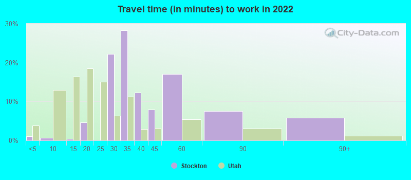
- Mean travel time to work (commute): 22.5 minutes

| Here: | 5.3 |
| Utah average: | 10.9 |
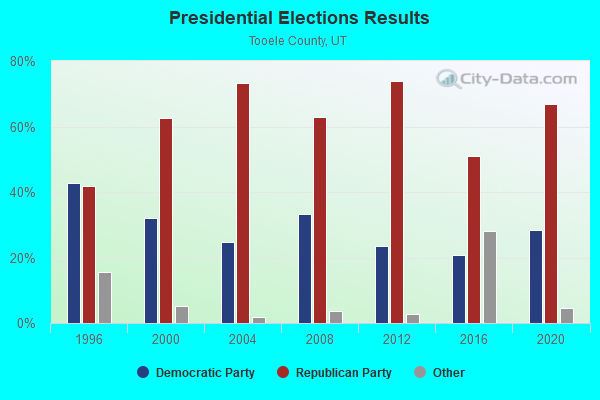
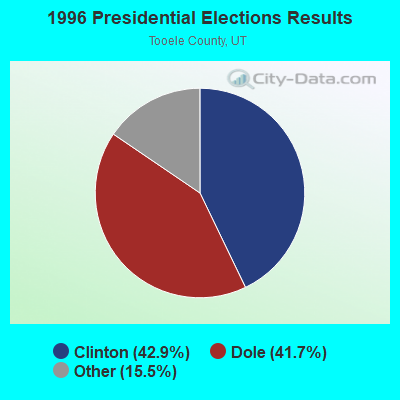
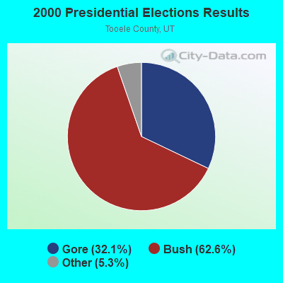
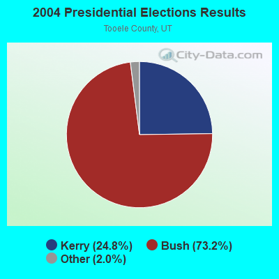
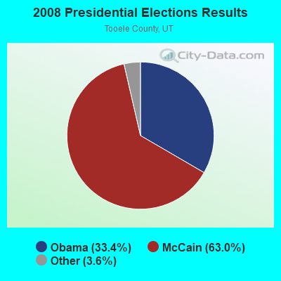
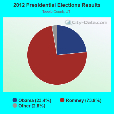
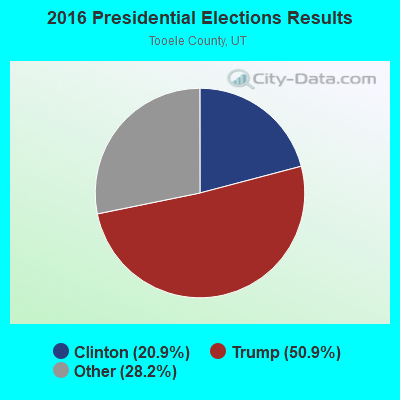
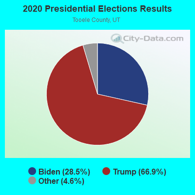
Graphs represent county-level data. Detailed 2008 Election Results
Religion statistics for Stockton, UT (based on Tooele County data)
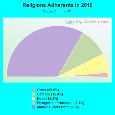
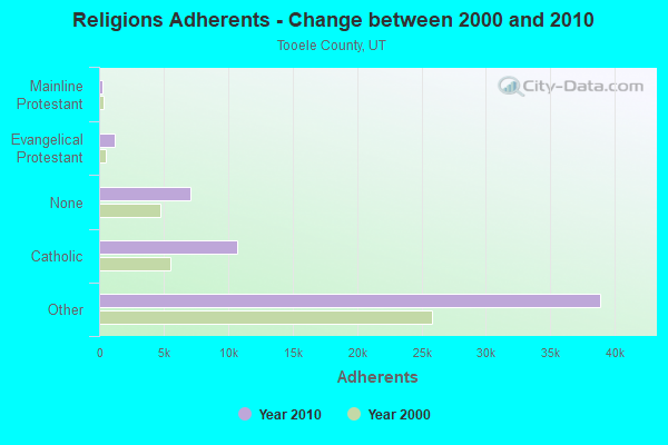
| Religion | Adherents | Congregations |
|---|---|---|
| Other | 38,895 | 88 |
| Catholic | 10,706 | 2 |
| Evangelical Protestant | 1,250 | 14 |
| Mainline Protestant | 293 | 2 |
| None | 7,074 | - |
Food Environment Statistics:
| This county: | 1.28 / 10,000 pop. |
| Utah: | 1.37 / 10,000 pop. |
| This county: | 0.18 / 10,000 pop. |
| Utah: | 0.18 / 10,000 pop. |
| Tooele County: | 0.55 / 10,000 pop. |
| Utah: | 0.41 / 10,000 pop. |
| Tooele County: | 2.37 / 10,000 pop. |
| State: | 2.82 / 10,000 pop. |
| Tooele County: | 2.37 / 10,000 pop. |
| Utah: | 5.09 / 10,000 pop. |
| Tooele County: | 7.9% |
| State: | 6.3% |
| This county: | 28.6% |
| Utah: | 23.6% |
Health and Nutrition:
| Stockton: | 46.4% |
| Utah: | 48.9% |
| Stockton: | 40.1% |
| Utah: | 47.0% |
| Stockton: | 28.7 |
| State: | 28.4 |
| Here: | 21.2% |
| Utah: | 21.0% |
| Here: | 11.7% |
| Utah: | 10.3% |
| This city: | 6.7 |
| State: | 6.8 |
| Stockton: | 33.3% |
| Utah: | 31.9% |
| Stockton: | 52.2% |
| Utah: | 57.4% |
| Here: | 75.8% |
| Utah: | 80.1% |
More about Health and Nutrition of Stockton, UT Residents
| Local government employment and payroll (March 2022) | |||||
| Function | Full-time employees | Monthly full-time payroll | Average yearly full-time wage | Part-time employees | Monthly part-time payroll |
|---|---|---|---|---|---|
| Streets and Highways | 1 | $3,910 | $46,920 | 0 | $0 |
| Parks and Recreation | 1 | $3,902 | $46,824 | 0 | $0 |
| Police Protection - Officers | 1 | $5,249 | $62,988 | 0 | $0 |
| Firefighters | 0 | $0 | 3 | $408 | |
| Other Government Administration | 0 | $0 | 2 | $778 | |
| Sewerage | 0 | $0 | 1 | $1,326 | |
| Water Supply | 0 | $0 | 1 | $1,326 | |
| Financial Administration | 0 | $0 | 1 | $2,112 | |
| Judicial and Legal | 0 | $0 | 1 | $892 | |
| Solid Waste Management | 0 | $0 | 1 | $600 | |
| Totals for Government | 3 | $13,061 | $52,244 | 10 | $7,441 |
Stockton government finances - Expenditure in 2017 (per resident):
- Current Operations - Water Utilities: $27,000 ($43.34)
- Total Salaries and Wages: $177,000 ($284.11)
- Water Utilities - Interest on Debt: $126,000 ($202.25)
Stockton government finances - Revenue in 2017 (per resident):
- Miscellaneous - General Revenue - Other: $32,000 ($51.36)
Interest Earnings: $0 ($0.00)
- Revenue - Water Utilities: $73,000 ($117.17)
- Tax - General Sales and Gross Receipts: $79,000 ($126.81)
Property: $72,000 ($115.57)
Stockton government finances - Debt in 2017 (per resident):
- Long Term Debt - Retired Unspecified Public Purpose: $3,178,000 ($5101.12)
Beginning Outstanding - Unspecified Public Purpose: $3,178,000 ($5101.12)
Businesses in Stockton, UT
- FedEx: 1
Strongest AM radio stations in Stockton:
- KSL (1160 AM; 50 kW; SALT LAKE CITY, UT; Owner: BONNEVILLE HOLDING COMPANY)
- KIQN (1010 AM; 50 kW; TOOELE, UT)
- KALL (700 AM; 50 kW; NORTH SALT LAKE CITY, UT; Owner: CITICASTERS LICENSES, L.P.)
- KKDS (1060 AM; 10 kW; SOUTH SALT LAKE, UT; Owner: HOLIDAY BROADCASTING COMPANY)
- KTKK (630 AM; 10 kW; SANDY, UT; Owner: UNITED BROADCASTING COMPANY)
- KWDZ (910 AM; 5 kW; SALT LAKE CITY, UT; Owner: ABC, INC.)
- KLLB (1510 AM; daytime; 10 kW; WEST JORDAN, UT; Owner: UNITED SECURITY FINANCIAL, INC.)
- KBEE (860 AM; 10 kW; SALT LAKE CITY, UT; Owner: CITADEL BROADCASTING COMPANY)
- KMRI (1550 AM; 10 kW; WEST VALLEY CITY, UT; Owner: KMRI RADIO, LLC)
- KBJA (1640 AM; 10 kW; SANDY, UT; Owner: UNITED BROADCASTING COMPANY, INC)
- KNRS (570 AM; 5 kW; SALT LAKE CITY, UT; Owner: CITICASTERS LICENSES, L.P.)
- KZNS (1280 AM; 10 kW; SALT LAKE CITY, UT; Owner: SIMMONS-SLC, LS, LLC)
- KFNZ (1320 AM; 5 kW; SALT LAKE CITY, UT; Owner: CITADEL BROADCASTING COMPANY)
Strongest FM radio stations in Stockton:
- KUUU (92.1 FM; TOOELE, UT; Owner: MILLCREEK BROADCASTING, L.L.C.)
- KSOP-FM (104.3 FM; SALT LAKE CITY, UT; Owner: KSOP, INC.)
- K272DP (102.3 FM; TOOELE, UT; Owner: FAMILY STATIONS, INC.)
- KRCL (90.9 FM; SALT LAKE CITY, UT; Owner: LISTENERS COMMUNITY RADIO OF UTAH)
- KBZN (97.9 FM; OGDEN, UT; Owner: CAPITOL BROADCASTING, INC.)
- KOSY-FM (106.5 FM; SPANISH FORK, UT; Owner: MERCURY BROADCASTING COMPANY, INC.)
- KRSP-FM (103.5 FM; SALT LAKE CITY, UT; Owner: SIMMONS-SLC, LS, LLC)
- KBER (101.1 FM; OGDEN, UT; Owner: CITADEL BROADCASTING COMPANY)
- KISN-FM (97.1 FM; SALT LAKE CITY, UT; Owner: CLEAR CHANNEL BROADCASTING LICENSES, INC.)
- KKAT (101.9 FM; OGDEN, UT; Owner: CITICASTERS LICENSES, L.P.)
- KSFI (100.3 FM; SALT LAKE CITY, UT; Owner: SIMMONS-SLC, LS, LLC)
- KUBL-FM (93.3 FM; SALT LAKE CITY, UT; Owner: CITADEL BROADCASTING COMPANY)
- KODJ (94.1 FM; SALT LAKE CITY, UT; Owner: CITICASTERS LICENSES, L.P.)
- KUER-FM (90.1 FM; SALT LAKE CITY, UT; Owner: UNIVERSITY OF UTAH)
- KBYU-FM (89.1 FM; PROVO, UT; Owner: BRIGHAM YOUNG UNIVERSITY)
- KURR (99.5 FM; BOUNTIFUL, UT; Owner: CITICASTERS LICENSES, L.P.)
- KBEE-FM (98.7 FM; SALT LAKE CITY, UT; Owner: CITADEL BROADCASTING COMPANY)
- K248AK (97.5 FM; DRAPER, UT; Owner: CITICASTERS LICENSES, L.P.)
- KXRK (96.3 FM; PROVO, UT; Owner: SIMMONS-SLC, LS, LLC)
- KQMB (102.7 FM; MIDVALE, UT; Owner: SIMMONS-SLC, LS, LLC)
TV broadcast stations around Stockton:
- KUTV (Channel 2; SALT LAKE CITY, UT; Owner: KUTV HOLDINGS, INC.)
- KEJT-LP (Channel 48; SALT LAKE CITY, UT; Owner: TELEMUNDO OF NORTHERN CALIFORNIA LICENSE CORP.)
- KUED (Channel 7; SALT LAKE CITY, UT; Owner: UNIVERSITY OF UTAH)
- KULC (Channel 9; OGDEN, UT; Owner: UTAH STATE BOARD OF REGENTS)
- KBYU-TV (Channel 11; PROVO, UT; Owner: BRIGHAM YOUNG UNIVERSITY)
- KSL-TV (Channel 5; SALT LAKE CITY, UT; Owner: BONNEVILLE HOLDING COMPANY)
- KUWB (Channel 30; OGDEN, UT; Owner: ACME TV LICENSES OF UTAH, LLC)
- KTVX (Channel 4; SALT LAKE CITY, UT; Owner: CLEAR CHANNEL BROADCASTING LICENSES, INC.)
- KJZZ-TV (Channel 14; SALT LAKE CITY, UT; Owner: LARRY H. MILLER COMMUNICATIONS CORP.)
- KSTU (Channel 13; SALT LAKE CITY, UT; Owner: FOX TELEVISION STATIONS INC.)
- KTMW (Channel 20; SALT LAKE CITY, UT; Owner: ALPHA & OMEGA COMMUNICATIONS, LLC)
- KUBX-LP (Channel 58; SALT LAKE CITY, UT; Owner: EQUITY BROADCASTING CORPORATION)
- Stockton, Utah
- Fatal accident count9
- Vehicles involved in fatal accidents12
- Fatal accidents involving drunk persons:2
- Fatalities12
- Persons involved in fatal accidents23
- Pedestrians involved in fatal accidents0
- Utah average
- Fatal accident count2049
- Vehicles involved in fatal accidents3122
- Fatal accidents involving drunk persons454
- Fatalities2314
- Persons involved in fatal accidents5506
- Pedestrians involved in fatal accidents275
FCC Registered Broadcast Land Mobile Towers:
7- Stockton Base 1.6 Km Nne (Lat: 40.466333 Lon: -112.353833), Type: Pole, Structure height: 16 m, Overall height: 21 m, Call Sign: KDS448,
Assigned Frequencies: 153.710 MHz, 153.560 MHz, 153.560 MHz, 153.620 MHz, Grant Date: 11/29/2012, Expiration Date: 01/15/2023, Cancellation Date: 10/30/2013, Certifier: Fred C Gailey, Registrant: Pacificorp, 825 N E Multnomah St 1500 Lct, Portland, OR 97232-2149, Phone: (503) 813-6915, Fax: (503) 813-6892, Email:
- 1 Mi Nne (Lat: 40.466889 Lon: -112.354111), Call Sign: KNGU987,
Assigned Frequencies: 451.575 MHz, Grant Date: 07/15/2003, Expiration Date: 09/15/2013, Cancellation Date: 12/31/2012, Registrant: Qwest Corporation, 700 W. Mineral Ave., Rm. Nd-E02.34, Littleton, CO 80120, Phone: (303) 707-8714, Fax: (303) 707-9624, Email:
- 1 Mi Nne (Lat: 40.466333 Lon: -112.187167), Call Sign: WCT854, Licensee ID: L00007703,
Assigned Frequencies: 457.250 MHz, Grant Date: 04/12/2012, Expiration Date: 06/15/2022, Cancellation Date: 10/30/2013, Registrant: Pacificorp, 825 Ne Multnomah St. 700 Lct, Portland, OR 97232-2149, Phone: (503) 813-6915, Fax: (503) 813-6434, Email:
- Stockton Station 1 Mi Nne (Lat: 40.466333 Lon: -112.353833), Call Sign: WGN989, Licensee ID: L00007703,
Assigned Frequencies: 154.463 MHz, Grant Date: 05/14/2003, Expiration Date: 08/15/2012, Cancellation Date: 08/25/2009, Registrant: Pacificorp, 825 Ne Multnomah St. 700 Lct, Portland, OR 97232-2149, Phone: (503) 813-6915, Fax: (503) 813-6434, Email:
- 11600 Stark Rd Bldg T25 (Lat: 40.163028 Lon: -113.248000), Type: Bant, Structure height: 7 m, Overall height: 9.1 m, Call Sign: WPZQ497,
Assigned Frequencies: 462.875 MHz, Grant Date: 02/20/2004, Expiration Date: 02/20/2014, Cancellation Date: 01/06/2014, Certifier: Dan Elroy, Registrant: Cara Enterprises Inc, Salt Lake City, UT 84117-0503, Phone: (801) 278-9728, Fax: (801) 278-7239
- Lat: 40.354139 Lon: -112.327361, Call Sign: WQKI573,
Assigned Frequencies: 152.870 MHz, 151.865 MHz, 151.925 MHz, 151.775 MHz, 151.955 MHz, 151.595 MHz, Grant Date: 06/03/2009, Expiration Date: 06/03/2019, Cancellation Date: 08/03/2019, Certifier: Dan Aragon, Registrant: Cara Enterprises Inc, Salt Lake City, UT 84117-0503, Phone: (801) 278-9728, Fax: (801) 278-7239, Email:
- Lat: 40.354139 Lon: -112.327361, Call Sign: WQKI574,
Assigned Frequencies: 151.685 MHz, 151.715 MHz, 151.745 MHz, 151.805 MHz, 152.975 MHz, 154.515 MHz, Grant Date: 06/03/2009, Expiration Date: 06/03/2019, Cancellation Date: 08/03/2019, Certifier: Dan Aragon, Registrant: Cara Enterprises Inc, Salt Lake City, UT 84117-0503, Phone: (801) 278-9728, Fax: (801) 278-7239, Email:
FCC Registered Microwave Towers:
8 (See the full list of FCC Registered Microwave Towers in this town)FCC Registered Amateur Radio Licenses:
20 (See the full list of FCC Registered Amateur Radio Licenses in Stockton)FAA Registered Aircraft:
2- Aircraft: CARBERRY DAVID H GLASTAR (Category: Land, Seats: 2, Weight: Up to 12,499 Pounds), Engine: LYCOMING O-360 SERIES (180 HP) (Reciprocating)
N-Number: 9023D, N9023D, N-9023D, Serial Number: 5897, Year manufactured: 2004, Airworthiness Date: 12/09/2004, Certificate Issue Date: 06/09/2004
Registrant (Individual): David H Carberry, Po Box 114, Stockton, UT 84071 - Aircraft: HOLT HENRY D KITFOX (Category: Land, Seats: 2, Weight: Up to 12,499 Pounds), Engine: ROTAX 532 (65 HP) (Reciprocating)
N-Number: 75HH, N75HH, N-75HH, Serial Number: 32, Year manufactured: 1986, Airworthiness Date: 12/31/2011
Registrant (Individual): Reported Sale, 1915 W Rim Rock Dr, Stockton, UT 84071
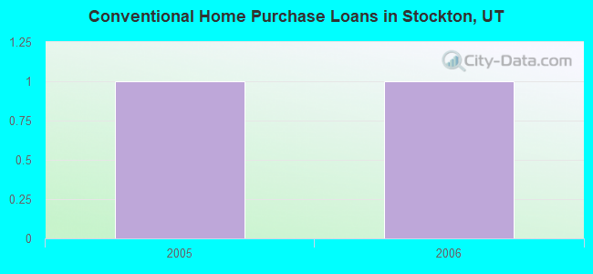
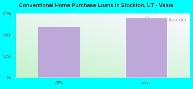
| Home Mortgage Disclosure Act Aggregated Statistics For Year 2009 (Based on 1 partial tract) | ||
| C) Refinancings | ||
|---|---|---|
| Number | Average Value | |
| LOANS ORIGINATED | 1 | $145,390 |
| APPLICATIONS APPROVED, NOT ACCEPTED | 0 | $0 |
| APPLICATIONS DENIED | 0 | $0 |
| APPLICATIONS WITHDRAWN | 0 | $0 |
| FILES CLOSED FOR INCOMPLETENESS | 0 | $0 |
Detailed HMDA statistics for the following Tracts: 1307.00
2002 - 2016 National Fire Incident Reporting System (NFIRS) incidents
- Fire incident types reported to NFIRS in Stockton, UT
- 9373.2%Outside Fires
- 2217.3%Structure Fires
- 97.1%Mobile Property/Vehicle Fires
- 32.4%Other
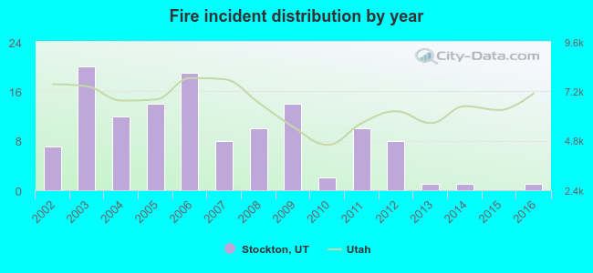 Based on the data from the years 2002 - 2016 the average number of fire incidents per year is 8. The highest number of fires - 20 took place in 2003, and the least - 0 in 2015. The data has a dropping trend.
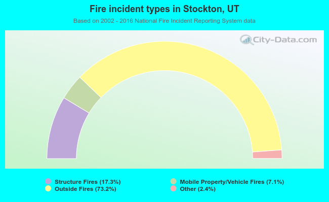 When looking into fire subcategories, the most reports belonged to: Outside Fires (73.2%), and Structure Fires (17.3%).
| Most common first names in Stockton, UT among deceased individuals | ||
| Name | Count | Lived (average) |
|---|---|---|
| John | 6 | 74.3 years |
| William | 4 | 76.3 years |
| George | 3 | 69.7 years |
| Mary | 3 | 83.3 years |
| Robert | 3 | 80.7 years |
| James | 2 | 83.0 years |
| Helen | 2 | 72.5 years |
| Frank | 2 | 81.0 years |
| Gasper | 2 | 71.0 years |
| Dorothy | 2 | 69.0 years |
| Most common last names in Stockton, UT among deceased individuals | ||
| Last name | Count | Lived (average) |
|---|---|---|
| Thomas | 6 | 84.2 years |
| Edwards | 4 | 71.3 years |
| Garcia | 3 | 87.0 years |
| Anderson | 3 | 75.7 years |
| Aufdemorte | 3 | 75.3 years |
| Lohman | 3 | 74.3 years |
| Hogan | 3 | 78.3 years |
| Borgogno | 3 | 71.3 years |
| Evans | 3 | 78.3 years |
| Johnson | 3 | 81.1 years |
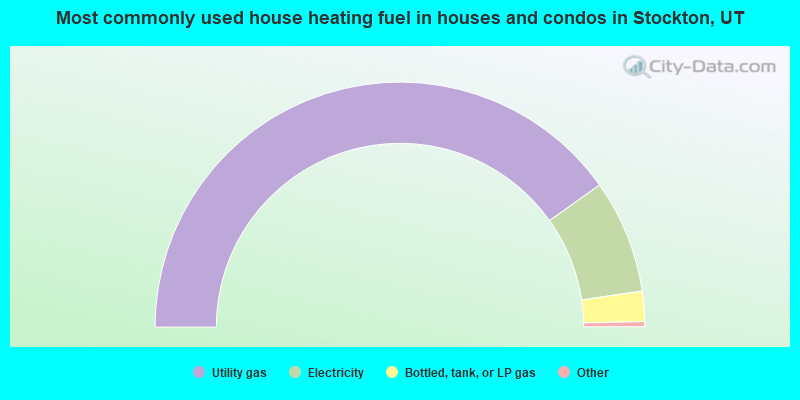
- 80.9%Utility gas
- 15.1%Electricity
- 4.0%Bottled, tank, or LP gas
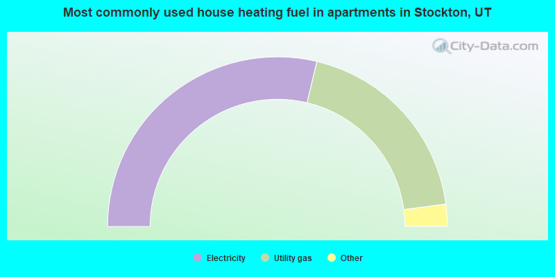
- 60.0%Electricity
- 40.0%Utility gas
Stockton compared to Utah state average:
- Unemployed percentage significantly below state average.
- Black race population percentage significantly below state average.
- Hispanic race population percentage significantly below state average.
- Median age above state average.
- Foreign-born population percentage significantly below state average.
- Renting percentage below state average.
- Length of stay since moving in significantly above state average.
- Percentage of population with a bachelor's degree or higher significantly below state average.