Please register to participate in our discussions with 2 million other members - it's free and quick! Some forums can only be seen by registered members. After you create your account, you'll be able to customize options and access all our 15,000 new posts/day with fewer ads.
Can you see why the mean track is the way it is? 50 latest Euro ensemble members shown here. Some members hit Florida, some stay well off shore. But the general path after hitting Haiti is moving NW into Bahamas then towards the Carolinas. Its after that which is still up in the air
Storm finished eyewall replacement cycle just before landfall and expanded its core winds field of reach. Not what you want to see an hour before a land falling storm. Making its way across that peninsula of Haiti now.
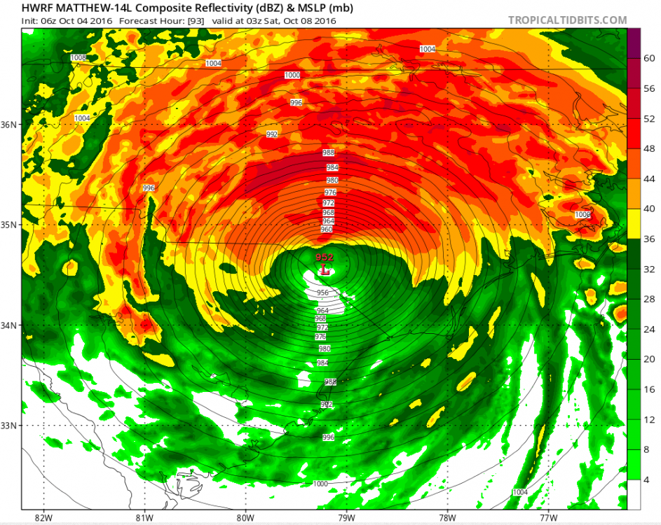
They are now thinking it will be a Hurricane off the NJ coast Sunday morning .. Notice the cone. Still can go OTS or right over land.
Quote:
BULLETIN
HURRICANE MATTHEW ADVISORY NUMBER 26
NWS NATIONAL HURRICANE CENTER MIAMI FL AL142016
1100 AM EDT TUE OCT 04 2016
...EYE OF EXTREMELY DANGEROUS HURRICANE MATTHEW MOVING OVER
THE GULF OF GONAVE AND IS HEADING FOR EASTERN CUBA...
SUMMARY OF 1100 AM EDT...1500 UTC...INFORMATION ----------------------------------------------- LOCATION...18.9N 74.3W ABOUT 35 MI...60 KM NNE OF TIBURON HAITI ABOUT 90 MI...145 KM S OF THE EASTERN TIP OF CUBA MAXIMUM SUSTAINED WINDS...145 MPH...230 KM/H PRESENT MOVEMENT...N OR 360 DEGREES AT 10 MPH...17 KM/H MINIMUM CENTRAL PRESSURE...950 MB...28.06 INCHES
DISCUSSION AND 48-HOUR OUTLOOK
------------------------------
At 1100 AM EDT (1500 UTC), the eye of Hurricane Matthew was located
in the Gulf of Gonave near latitude 18.9 North, longitude 74.3 West.
Matthew is moving toward the north near 10 mph (17 km/h). On this
track the eye of Matthew will move over the Windward Passage and
eastern Cuba today. A turn toward the north-northwest is expected
by Wednesday, followed by a northwest turn Wednesday night. Matthew
is expected to move near or over portions of the southeastern and
central Bahamas tonight and Wednesday, and approach the northwestern
Bahamas Wednesday night.
Maximum sustained winds remain near 145 mph (230 km/h) with
higher gusts. Matthew is a category 4 hurricane on the Saffir-
Simpson Hurricane Wind Scale. Some fluctuations in intensity are
possible during the next couple of days, but Matthew is expected to
remain a powerful hurricane through at least Wednesday night.
Hurricane-force winds extend outward up to 60 miles (95 km) from the
center and tropical-storm-force winds extend outward up to 185 miles
(295 km).
The estimated minimum central pressure is 950 mb (28.06 inches).
NEXT ADVISORY
-------------
Next intermediate advisory at 200 PM EDT.
Next complete advisory at 500 PM EDT.
Please register to post and access all features of our very popular forum. It is free and quick. Over $68,000 in prizes has already been given out to active posters on our forum. Additional giveaways are planned.
Detailed information about all U.S. cities, counties, and zip codes on our site: City-data.com.

 Please register to participate in our discussions with 2 million other members - it's free and quick! Some forums can only be seen by registered members. After you create your account, you'll be able to customize options and access all our 15,000 new posts/day with fewer ads.