Andrews AFB, Maryland

Submit your own pictures of this place and show them to the world
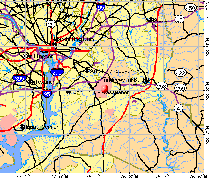
- OSM Map
- General Map
- Google Map
- MSN Map
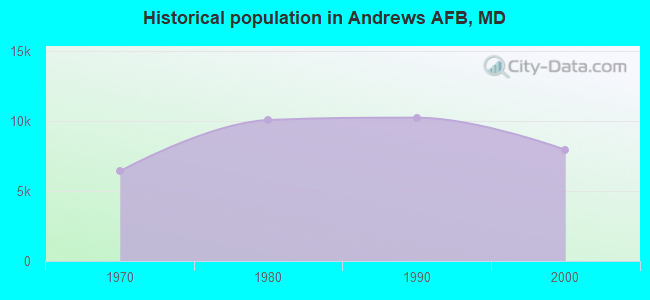
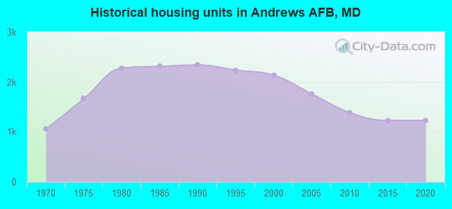
Population change since 2000: -62.5%
| Males: 1,392 | |
| Females: 1,581 |
| Median resident age: | 23.8 years |
| Maryland median age: | 39.7 years |
| Andrews AFB: | $80,970 |
| MD: | $94,991 |
Estimated per capita income in 2022: $28,578 (it was $16,520 in 2000)
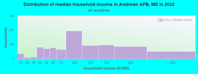
Andrews AFB CDP income, earnings, and wages data
Estimated median house or condo value in 2022: $-719,754,708 (it was $112,500 in 2000)
| Andrews AFB: | |
| MD: |
Mean prices in 2022: all housing units: $424,688; detached houses: $460,769; townhouses or other attached units: $335,894; in 2-unit structures: $711,936; in 3-to-4-unit structures: $270,628; in 5-or-more-unit structures: $250,132; mobile homes: $129,345; occupied boats, rvs, vans, etc.: $551,726
Median gross rent in 2022: $2,529.
(7.4% for White Non-Hispanic residents, 0.6% for Black residents, 7.9% for Hispanic or Latino residents, 8.7% for other race residents, 11.8% for two or more races residents)
Detailed information about poverty and poor residents in Andrews AFB, MD

Compare current foreclosures near Andrews AFB, MD:
| Photo | Address | Area | Beds / Baths | Price | Details |
|---|---|---|---|---|---|

|
#1
Cathedral Ave NW Apt 108
Washington, DC 20016
|
765 sq. feet
|
1 baths 1 beds |
$279,900
|
show details |

|
#2
9th St NW
Washington, DC 20011
|
1,604 sq. feet
|
2 baths 3 beds |
$598,000
|
show details |

|
#3
Carousel Ct
Upper Marlboro, MD 20772
|
2,112 sq. feet
|
2 baths 3 beds |
$412,000
|
show details |

|
#4
Eastern Ave NE
Washington, DC 20011
|
1,024 sq. feet
|
1 baths 3 beds |
$395,000
|
show details |

|
#5
Ensleigh Ln
Bowie, MD 20716
|
1,656 sq. feet
|
2 baths 3 beds |
$389,900
|
show details |

|
#6
Henson Ln
Temple Hills, MD 20748
|
1,566 sq. feet
|
2 baths 3 beds |
$300,000
|
show details |

|
#7
Gladys Retreat Cir
Bowie, MD 20720
|
2,880 sq. feet
|
3 baths 3 beds |
$409,900
|
show details |

|
#8
17th St NW Apt 504
Washington, DC 20009
|
800 sq. feet
|
1 baths 1 beds |
$405,000
|
show details |

|
#9
Pickett Dr
Suitland, MD 20746
|
1,296 sq. feet
|
1 baths 2 beds |
$349,900
|
show details |

|
#10
Bannister Cir
Waldorf, MD 20602
|
1,196 sq. feet
|
3 baths 4 beds |
$449,900
|
show details |
| Photo | Address | Area | Beds / Baths | Price | Details |
|---|---|---|---|---|---|

|
#11
19th St NW
Washington, DC 20036
|
2,515 sq. feet
|
6 baths 8 beds |
$1,684,800
|
show details |

|
#12
Heming Ln
Bowie, MD 20716
|
1,800 sq. feet
|
2 baths 3 beds |
$400,000
|
show details |

|
#13
Old Fort Rd
Fort Washington, MD 20744
|
721 sq. feet
|
1 baths 2 beds |
$179,900
|
show details |

|
#14
Addison Rd
Capitol Heights, MD 20743
|
1,400 sq. feet
|
1 baths 3 beds |
$260,000
|
show details |

|
#15
Brooke Ln
Upper Marlboro, MD 20772
|
- sq. feet
|
5 baths 6 beds |
$949,000
|
show details |

|
#16
T St SE Apt 3
Washington, DC 20020
|
- sq. feet
|
2 baths 4 beds |
$339,900
|
show details |

|
#17
Delaware Ave SW Apt N720
Washington, DC 20024
|
- sq. feet
|
1 baths 1 beds |
$149,900
|
show details |

|
#18
Holbrook Ter NE
Washington, DC 20002
|
3,164 sq. feet
|
4 baths 8 beds |
show details | |

|
#19
4th St NE Apt 2
Washington, DC 20002
|
1,061 sq. feet
|
2 baths 2 beds |
show details | |

|
#20
Scottsdale Pl
Waldorf, MD 20602
|
2,068 sq. feet
|
3 baths 3 beds |
show details |
| Photo | Address | Area | Beds / Baths | Price | Details |
|---|---|---|---|---|---|

|
#21
1918 M Street NE
Washington, DC 20002
|
5,487 sq. feet
|
12 baths 18 beds |
show details | |

|
#22
Girard St NE
Washington, DC 20017
|
1,270 sq. feet
|
1 baths 3 beds |
show details | |

|
#23
S George Mason Dr Unit 918n
Falls Church, VA 22041
|
752 sq. feet
|
1 baths 1 beds |
show details | |

|
#24
Dana Dr
Hyattsville, MD 20783
|
2,380 sq. feet
|
2 baths 3 beds |
show details | |

|
#25
16th St S Apt 696
Arlington, VA 22204
|
1,008 sq. feet
|
1 baths 2 beds |
show details | |

|
#26
Hill Way
Suitland, MD 20746
|
1,539 sq. feet
|
2 baths 4 beds |
show details | |

|
#27
Deale Rd
Tracys Landing, MD 20779
|
1,472 sq. feet
|
1 baths 3 beds |
show details | |

|
#28
47th St NE
Washington, DC 20019
|
2,363 sq. feet
|
2 baths 5 beds |
show details | |

|
#29
Crelin Pl
Lanham, MD 20706
|
1,932 sq. feet
|
3 baths 4 beds |
show details | |

|
#30
Kenyon St NW
Washington, DC 20010
|
3,456 sq. feet
|
3 baths 6 beds |
show details |
| Photo | Address | Area | Beds / Baths | Price | Details |
|---|---|---|---|---|---|

|
#31
Rugged Ln
Capitol Heights, MD 20743
|
- sq. feet
|
3 baths 4 beds |
show details | |

|
#32
Connecticut Ave NW Apt 606
Washington, DC 20008
|
160 sq. feet
|
1 baths 1 beds |
show details | |

|
#33
Carousel Ct
Upper Marlboro, MD 20772
|
1,608 sq. feet
|
4 baths 4 beds |
show details | |

|
#34
Carrollsburg Pl SW
Washington, DC 20024
|
1,720 sq. feet
|
2 baths 3 beds |
show details | |

|
#35
Lake Hill Ct
Waldorf, MD 20603
|
1,948 sq. feet
|
2 baths 3 beds |
show details | |

|
#36
Fern Pl NW
Washington, DC 20012
|
1,920 sq. feet
|
1 baths 4 beds |
show details | |

|
#37
Dubois Pl SE
Washington, DC 20019
|
1,024 sq. feet
|
2 baths 3 beds |
show details | |

|
#38
Horner Pl SE
Washington, DC 20032
|
1,024 sq. feet
|
1 baths 3 beds |
show details | |

|
#39
Dery Rd
Upper Marlboro, MD 20772
|
816 sq. feet
|
1 baths 3 beds |
show details | |

|
#40
Cathedral Ave NW Apt 404w
Washington, DC 20016
|
803 sq. feet
|
1 baths 1 beds |
show details |
| Photo | Address | Area | Beds / Baths | Price | Details |
|---|---|---|---|---|---|

|
#41
Deanwood Dr
Capitol Heights, MD 20743
|
640 sq. feet
|
1 baths 1 beds |
show details | |

|
#42
Baileys Pond Rd
Accokeek, MD 20607
|
4,677 sq. feet
|
2 baths 7 beds |
show details | |

|
#43
Astor Pl SE
Washington, DC 20019
|
2,516 sq. feet
|
4 baths 4 beds |
show details | |

|
#44
Chadsey Ln
Brandywine, MD 20613
|
2,480 sq. feet
|
3 baths 4 beds |
show details | |

|
#45
Kalmia Rd NW
Washington, DC 20012
|
2,382 sq. feet
|
4 baths 4 beds |
show details | |

|
#46
Peacock Dr
Hyattsville, MD 20785
|
1,452 sq. feet
|
2 baths 3 beds |
show details | |

|
#47
Saint Bernadines Way
Capitol Heights, MD 20743
|
1,176 sq. feet
|
1 baths 3 beds |
show details | |

|
#48
Dennington Dr
Bowie, MD 20721
|
4,164 sq. feet
|
2 baths 4 beds |
show details | |

|
#49
Winthrop St
Oxon Hill, MD 20745
|
1,020 sq. feet
|
1 baths 3 beds |
show details | |

|
Check over 1 million property listings on Foreclosure.com!
|
browse all offers | |||


- 1,42546.5%White alone
- 78025.4%Black alone
- 42513.9%Hispanic
- 32110.5%Two or more races
- 792.6%Asian alone
- 210.7%Other race alone
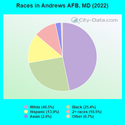
Races in Andrews AFB detailed stats: ancestries, foreign born residents, place of birth
 Recent articles from our blog. Our writers, many of them Ph.D. graduates or candidates, create easy-to-read articles on a wide variety of topics.

 | FBI HQ relocation decision postponed yet again. (540 replies) |
| Orders to Andrews AFB, Current Suggestions on Good Neighborhoods (18 replies) |
| PG County: Good/Bad Area Breakdown (48 replies) |
| Waldorf-MD? (69 replies) |
| Moving To The Maryland Suburbs of DC? START HERE! (412 replies) |
| Prince George's County, the new gay mecca? (33 replies) |
Latest news from Andrews AFB, MD collected exclusively by city-data.com from local newspapers, TV, and radio stations
Ancestries: American (14.6%), European (7.8%), Irish (5.9%), Jamaican (3.7%), German (3.6%), French Canadian (3.0%).
Current Local Time: EST time zone
Land area: 6.84 square miles.
Population density: 435 people per square mile (low).

166 residents are foreign born (2.9% Latin America, 1.2% Asia, 0.6% Europe).
| This place: | 5.4% |
| Maryland: | 15.7% |
| Andrews AFB CDP: | 0.3% ($350) |
| Maryland: | 1.2% ($1,782) |
Nearest city with pop. 50,000+: Washington, DC  (10.8 miles , pop. 572,059).
Nearest city with pop. 1,000,000+: Philadelphia, PA (123.9 miles , pop. 1,517,550).
Nearest cities:
), ), ), ), ), ), ), )Latitude: 38.80 N, Longitude: 76.87 W
Daytime population change due to commuting: +9,330 (+304.3%)
Workers who live and work in this place: 1,074 (84.8%)

| Here: | 2.1% |
| Maryland: | 2.0% |
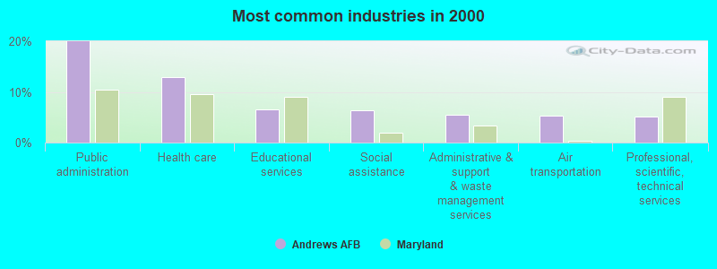
- Public administration (20.0%)
- Health care (12.9%)
- Educational services (6.5%)
- Social assistance (6.5%)
- Administrative & support & waste management services (5.5%)
- Air transportation (5.3%)
- Professional, scientific, technical services (5.1%)
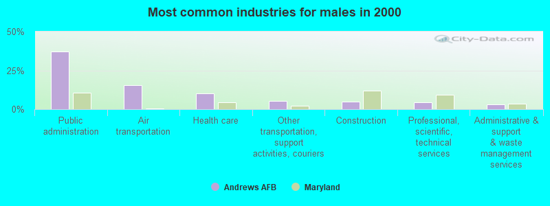
- Public administration (37.4%)
- Air transportation (15.5%)
- Health care (10.0%)
- Other transportation, support activities, couriers (5.5%)
- Construction (4.9%)
- Professional, scientific, technical services (4.2%)
- Administrative & support & waste management services (3.0%)
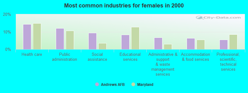
- Health care (14.3%)
- Public administration (12.0%)
- Social assistance (9.4%)
- Educational services (8.3%)
- Administrative & support & waste management services (6.7%)
- Accommodation & food services (6.4%)
- Professional, scientific, technical services (5.5%)
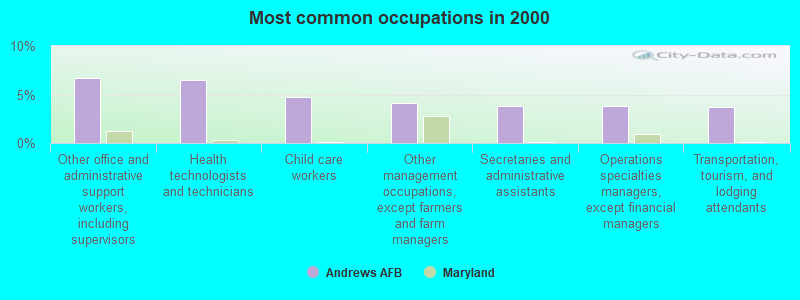
- Other office and administrative support workers, including supervisors (6.7%)
- Health technologists and technicians (6.5%)
- Child care workers (4.7%)
- Other management occupations, except farmers and farm managers (4.1%)
- Secretaries and administrative assistants (3.9%)
- Operations specialties managers, except financial managers (3.8%)
- Transportation, tourism, and lodging attendants (3.7%)
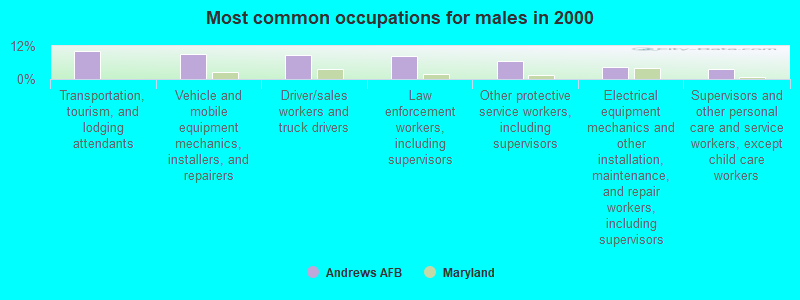
- Transportation, tourism, and lodging attendants (10.2%)
- Vehicle and mobile equipment mechanics, installers, and repairers (9.1%)
- Driver/sales workers and truck drivers (8.7%)
- Law enforcement workers, including supervisors (8.3%)
- Other protective service workers, including supervisors (6.6%)
- Electrical equipment mechanics and other installation, maintenance, and repair workers, including supervisors (4.5%)
- Supervisors and other personal care and service workers, except child care workers (3.6%)
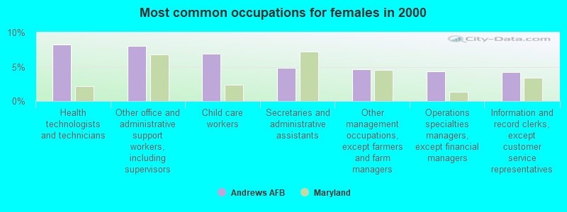
- Health technologists and technicians (8.3%)
- Other office and administrative support workers, including supervisors (8.1%)
- Child care workers (6.9%)
- Secretaries and administrative assistants (4.9%)
- Other management occupations, except farmers and farm managers (4.7%)
- Operations specialties managers, except financial managers (4.4%)
- Information and record clerks, except customer service representatives (4.3%)
Average climate in Andrews AFB, Maryland
Based on data reported by over 4,000 weather stations


(lower is better)
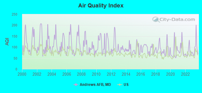
Air Quality Index (AQI) level in 2023 was 96.6. This is worse than average.
| City: | 96.6 |
| U.S.: | 72.6 |
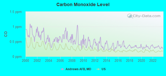
Carbon Monoxide (CO) [ppm] level in 2023 was 0.290. This is about average. Closest monitor was 4.7 miles away from the city center.
| City: | 0.290 |
| U.S.: | 0.251 |
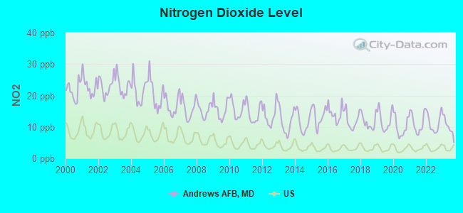
Nitrogen Dioxide (NO2) [ppb] level in 2023 was 10.1. This is significantly worse than average. Closest monitor was 1.5 miles away from the city center.
| City: | 10.1 |
| U.S.: | 5.1 |
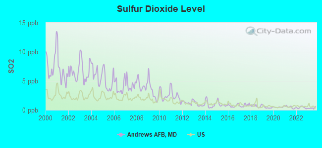
Sulfur Dioxide (SO2) [ppb] level in 2023 was 0.329. This is significantly better than average. Closest monitor was 1.5 miles away from the city center.
| City: | 0.329 |
| U.S.: | 1.515 |
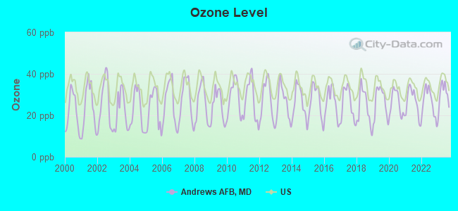
Ozone [ppb] level in 2023 was 29.9. This is about average. Closest monitor was 4.7 miles away from the city center.
| City: | 29.9 |
| U.S.: | 33.3 |
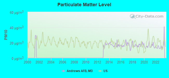
Particulate Matter (PM10) [µg/m3] level in 2022 was 13.9. This is better than average. Closest monitor was 4.7 miles away from the city center.
| City: | 13.9 |
| U.S.: | 19.2 |
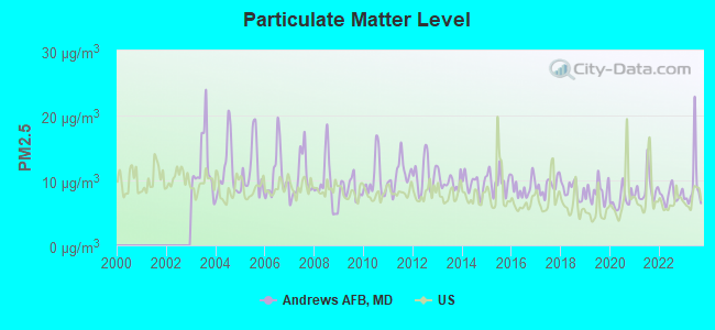
Particulate Matter (PM2.5) [µg/m3] level in 2023 was 9.30. This is about average. Closest monitor was 4.7 miles away from the city center.
| City: | 9.30 |
| U.S.: | 8.11 |
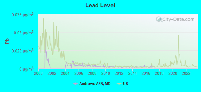
Lead (Pb) [µg/m3] level in 2016 was 0.00212. This is significantly better than average. Closest monitor was 6.7 miles away from the city center.
| City: | 0.00212 |
| U.S.: | 0.00931 |
Tornado activity:
Andrews AFB-area historical tornado activity is slightly above Maryland state average. It is 7% greater than the overall U.S. average.
On 4/28/2002, a category F4 (max. wind speeds 207-260 mph) tornado 24.2 miles away from the Andrews AFB place center killed 3 people and injured 122 people and caused $124 million in damages.
On 9/24/2001, a category F3 (max. wind speeds 158-206 mph) tornado 10.5 miles away from the place center killed 2 people and injured 55 people and caused $101 million in damages.
Earthquake activity:
Andrews AFB-area historical earthquake activity is significantly above Maryland state average. It is 58% smaller than the overall U.S. average.On 8/23/2011 at 17:51:04, a magnitude 5.8 (5.8 MW, Depth: 3.7 mi, Class: Moderate, Intensity: VI - VII) earthquake occurred 84.6 miles away from the city center
On 8/25/2011 at 05:07:52, a magnitude 4.5 (4.5 ML, Depth: 4.2 mi, Class: Light, Intensity: IV - V) earthquake occurred 83.9 miles away from Andrews AFB center
On 1/16/1994 at 01:49:16, a magnitude 4.6 (4.6 MB, 4.6 LG, Depth: 3.1 mi) earthquake occurred 114.6 miles away from the city center
On 12/9/2003 at 20:59:18, a magnitude 4.5 (4.5 ML, Depth: 6.2 mi) earthquake occurred 97.6 miles away from the city center
On 12/9/2003 at 20:59:14, a magnitude 4.5 (4.5 MB, 4.5 LG) earthquake occurred 101.1 miles away from Andrews AFB center
On 9/25/1998 at 19:52:52, a magnitude 5.2 (4.8 MB, 4.3 MS, 5.2 LG, 4.5 MW, Depth: 3.1 mi) earthquake occurred 263.2 miles away from the city center
Magnitude types: regional Lg-wave magnitude (LG), body-wave magnitude (MB), local magnitude (ML), surface-wave magnitude (MS), moment magnitude (MW)
Natural disasters:
The number of natural disasters in Prince George's County (16) is near the US average (15).Major Disasters (Presidential) Declared: 11
Emergencies Declared: 5
Causes of natural disasters: Hurricanes: 5, Winter Storms: 5, Snowstorms: 3, Floods: 2, Storms: 2, Tropical Storms: 2, Blizzard: 1, Heavy Rain: 1, Ice Storm: 1, Snowfall: 1 (Note: some incidents may be assigned to more than one category).

Hospitals and medical centers near Andrews AFB:
- RAI - OLD ALEXANDRIA-CLINTON (Dialysis Facility, about 2 miles away; CLINTON, MD)
- QUALITY CARE DIALYSIS - SOUTHERN MARYLAND (Dialysis Facility, about 2 miles away; CAMP SPRINGS, MD)
- PARKWOOD HOSPITAL (Hospital, about 3 miles away; CLINTON, MD)
- FMC - SURRATTS (Dialysis Facility, about 3 miles away; CLINTON, MD)
- DAVITA - SOUTHERN MARYLAND (Dialysis Facility, about 3 miles away; CLINTON, MD)
- CLINTON NURSING AND REHABILITATION CENTER (Nursing Home, about 3 miles away; CLINTON, MD)
- FORESTVILLE HEALTH AND REHABILITATION CENTER (Nursing Home, about 4 miles away; FORESTVILLE, MD)
Amtrak stations near Andrews AFB:
- 10 miles: WASHINGTON (50 MASSACHUSETTS AVE. N.E.) . Services: ticket office, fully wheelchair accessible, enclosed waiting area, public restrooms, public payphones, full-service food facilities and snack bar, ATM, paid short-term parking, paid long-term parking, car rental agency, taxi stand, public transit connection.
- 11 miles: ALEXANDRIA (110 CALLAHAN DR.) . Services: ticket office, partially wheelchair accessible, enclosed waiting area, public restrooms, public payphones, vending machines, ATM, free short-term parking, free long-term parking, call for car rental service, call for taxi service, public transit connection.
- 11 miles: NEW CARROLLTON (4300 GARDEN CITY DR.) . Services: ticket office, fully wheelchair accessible, enclosed waiting area, public restrooms, public payphones, snack bar, ATM, paid short-term parking, paid long-term parking, call for car rental service, taxi stand, public transit connection.
Colleges/universities with over 2000 students nearest to Andrews AFB:
- Strayer University-Maryland (about 4 miles; Suitland, MD; Full-time enrollment: 2,748)
- Prince George's Community College (about 7 miles; Largo, MD; FT enrollment: 8,537)
- Strayer University-Global Region (about 12 miles; Washington, DC; FT enrollment: 2,613)
- Howard University (about 12 miles; Washington, DC; FT enrollment: 7,838)
- Catholic University of America (about 12 miles; Washington, DC; FT enrollment: 5,365)
- George Washington University (about 12 miles; Washington, DC; FT enrollment: 18,928)
- Strayer University-Virginia (about 13 miles; Arlington, VA; FT enrollment: 7,005)
Points of interest:
Notable locations in Andrews AFB: Andrews Air Force Base Fire Station 2 (A), Andrews Air Force Base Fire Station 3 (B), Andrews Air Force Base Fire Station 1 Headquarters (C). Display/hide their locations on the map
Shopping Center: Allentown Outlet Mall Shopping Center (1). Display/hide its location on the map
Church in Andrews AFB: Bells United Methodist Church (A). Display/hide its location on the map
Cemetery: Bells Cemetery (1). Display/hide its location on the map
Birthplace of: Derrick Delmore - Figure skater.
| This place: | 2.9 people |
| Maryland: | 2.6 people |
| This place: | 81.2% |
| Whole state: | 67.1% |
| This place: | 1.3% |
| Whole state: | 6.4% |
Likely homosexual households (counted as self-reported same-sex unmarried-partner households)
- Lesbian couples: 0.2% of all households
- Gay men: 0.5% of all households
People in group quarters in Andrews AFB in 2000:
- 558 people in military barracks, etc.
- 482 people in wards in military hospitals for patients who have no usual home elsewhere
- 334 people in military transient quarters for temporary residents
For population 15 years and over in Andrews AFB:
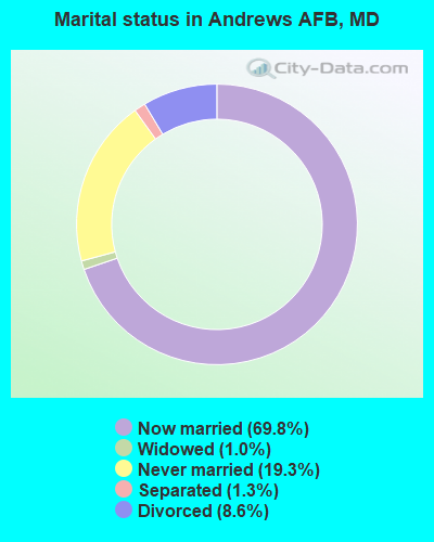
- Never married: 19.3%
- Now married: 69.8%
- Separated: 1.3%
- Widowed: 1.0%
- Divorced: 8.6%
For population 25 years and over in Andrews AFB:
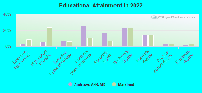
- High school or higher: 96.6%
- Bachelor's degree or higher: 39.4%
- Graduate or professional degree: 17.3%
- Unemployed: 4.2%
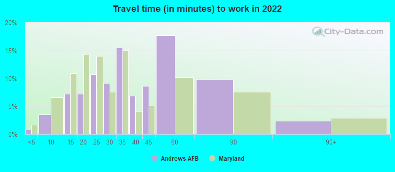
- Mean travel time to work (commute): 14.1 minutes
| Here: | 9.6 |
| Maryland average: | 12.7 |
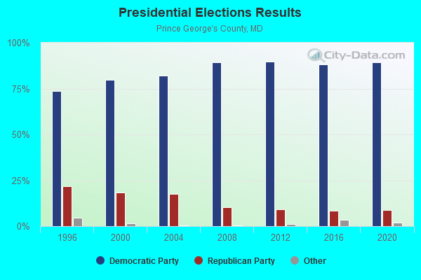
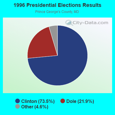
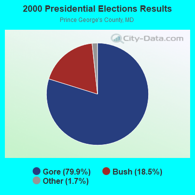
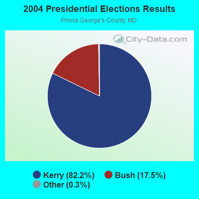
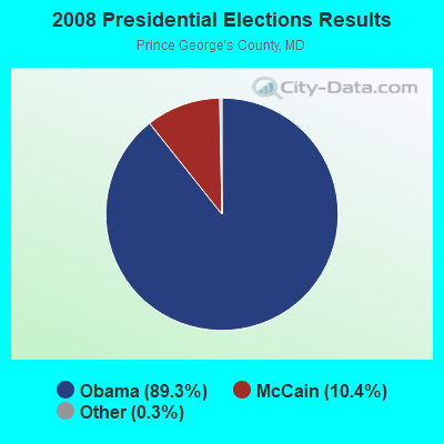

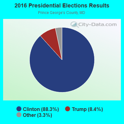
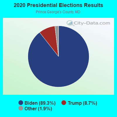
Graphs represent county-level data. Detailed 2008 Election Results
Religion statistics for Andrews AFB, MD (based on Prince George's County data)
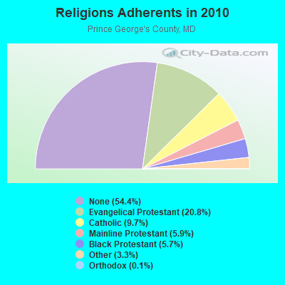
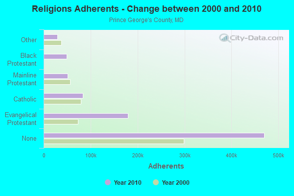
| Religion | Adherents | Congregations |
|---|---|---|
| Evangelical Protestant | 179,374 | 430 |
| Catholic | 83,959 | 35 |
| Mainline Protestant | 51,153 | 156 |
| Black Protestant | 48,984 | 66 |
| Other | 28,743 | 57 |
| Orthodox | 1,218 | 6 |
| None | 469,989 | - |
Food Environment Statistics:
| Prince George's County: | 1.70 / 10,000 pop. |
| Maryland: | 1.96 / 10,000 pop. |
| This county: | 0.02 / 10,000 pop. |
| State: | 0.07 / 10,000 pop. |
| Prince George's County: | 1.60 / 10,000 pop. |
| Maryland: | 1.22 / 10,000 pop. |
| Prince George's County: | 1.66 / 10,000 pop. |
| State: | 2.05 / 10,000 pop. |
| Here: | 3.24 / 10,000 pop. |
| State: | 5.40 / 10,000 pop. |
| This county: | 10.5% |
| Maryland: | 9.1% |
| Prince George's County: | 30.7% |
| Maryland: | 26.7% |
| This county: | 16.7% |
| State: | 15.5% |
Health and Nutrition:
| This city: | 50.5% |
| Maryland: | 50.1% |
| Andrews AFB: | 53.4% |
| State: | 47.6% |
| This city: | 28.2 |
| Maryland: | 28.8 |
| Here: | 18.5% |
| Maryland: | 20.0% |
| This city: | 9.8% |
| State: | 11.3% |
| Andrews AFB: | 6.8 |
| State: | 6.8 |
| This city: | 29.7% |
| Maryland: | 34.1% |
| This city: | 62.7% |
| State: | 56.5% |
| Andrews AFB: | 86.5% |
| Maryland: | 80.5% |
More about Health and Nutrition of Andrews AFB, MD Residents
6.37% of this county's 2021 resident taxpayers lived in other counties in 2020 ($55,200 average adjusted gross income)
| Here: | 6.37% |
| Maryland average: | 7.42% |
0.04% of residents moved from foreign countries ($466 average AGI)
Prince George's County: 0.04% Maryland average: 0.05%
Top counties from which taxpayers relocated into this county between 2020 and 2021:
| from District of Columbia, DC | |
| from Montgomery County, MD | |
| from Anne Arundel County, MD |
8.15% of this county's 2020 resident taxpayers moved to other counties in 2021 ($59,145 average adjusted gross income)
| Here: | 8.15% |
| Maryland average: | 7.91% |
0.05% of residents moved to foreign countries ($401 average AGI)
Prince George's County: 0.05% Maryland average: 0.04%
Top counties to which taxpayers relocated from this county between 2020 and 2021:
| to Montgomery County, MD | |
| to Anne Arundel County, MD | |
| to District of Columbia, DC |
| Businesses in Andrews AFB, MD | ||||
| Name | Count | Name | Count | |
|---|---|---|---|---|
| Burger King | 1 | H&R Block | 1 | |
| Firestone Complete Auto Care | 1 | Starbucks | 1 | |
| GNC | 1 | Subway | 1 | |
Strongest AM radio stations in Andrews AFB:
- WPGC (1580 AM; 50 kW; MORNINGSIDE, MD; Owner: INFINITY WPGC(AM), INC.)
- WTEM (980 AM; 50 kW; WASHINGTON, DC; Owner: AMFM RADIO LICENSES, L.L.C.)
- WWGB (1030 AM; daytime; 50 kW; INDIAN HEAD, MD; Owner: GOOD BODY MEDIA, LLC)
- WTOP (1500 AM; 50 kW; WASHINGTON, DC; Owner: BONNEVILLE HOLDING COMPANY)
- WBIS (1190 AM; 50 kW; ANNAPOLIS, MD; Owner: NATIONS RADIO, LLC)
- WKDL (730 AM; 8 kW; ALEXANDRIA, VA; Owner: MEGA COMMUNICATIONS OF ALEXANDRIA LICENSEE, LLC)
- WUST (1120 AM; daytime; 20 kW; WASHINGTON, DC)
- WCBM (680 AM; 50 kW; BALTIMORE, MD; Owner: WCBM MARYLAND, INC.)
- WMET (1150 AM; 50 kW; GAITHERSBURG, MD; Owner: BELTWAY ACQUISITION CORPORATION)
- WYCB (1340 AM; 1 kW; WASHINGTON, DC; Owner: RADIO ONE LICENSES, LLC)
- WBAL (1090 AM; 50 kW; BALTIMORE, MD; Owner: HEARST RADIO, INC.)
- WABS (780 AM; daytime; 5 kW; ARLINGTON, VA; Owner: SALEM MEDIA OF VIRGINIA, INC.)
- WWLG (1370 AM; 50 kW; BALTIMORE, MD; Owner: M-10 BROADCASTING, INC.)
Strongest FM radio stations in Andrews AFB:
- WPGC-FM (95.5 FM; MORNINGSIDE, MD; Owner: INFINITY BROADCASTING CORPORATION OF MARYLAND)
- WHFS (99.1 FM; ANNAPOLIS, MD; Owner: INFINITY BROADCASTING OPERATIONS, INC.)
- WWZZ (104.1 FM; WALDORF, MD; Owner: BONNEVILLE HOLDING COMPANY)
- WRQX (107.3 FM; WASHINGTON, DC; Owner: WMAL, INC.)
- WHUR-FM (96.3 FM; WASHINGTON, DC; Owner: THE HOWARD UNIVERSITY)
- WASH (97.1 FM; WASHINGTON, DC; Owner: AMFM RADIO LICENSES, L.L.C.)
- WBIG-FM (100.3 FM; WASHINGTON, DC; Owner: AMFM RADIO LICENSES, L.L.C.)
- WKYS (93.9 FM; WASHINGTON, DC; Owner: RADIO ONE LICENSES, LLC)
- WARW (94.7 FM; BETHESDA, MD; Owner: INFINITY BROADCASTING OPERATIONS, INC.)
- WWDC-FM (101.1 FM; WASHINGTON, DC; Owner: AMFM RADIO LICENSES, L.L.C.)
- WIHT (99.5 FM; WASHINGTON, DC; Owner: AMFM RADIO LICENSES, L.L.C.)
- WCSP-FM (90.1 FM; WASHINGTON, DC; Owner: NATIONAL CABLE SATELLITE CORPORATION)
- WETA (90.9 FM; WASHINGTON, DC; Owner: GREATER WASHINGTON EDUCATIONAL TELECOMMUNICATIONS ASSN.)
- WGTS (91.9 FM; TAKOMA PARK, MD; Owner: COLUMBIA UNION COLLEGE BROADCASTING, INC.)
- WJFK-FM (106.7 FM; MANASSAS, VA; Owner: INFINITY BROADCASTING CORP. OF WASHINGTON, DC)
- WGMS-FM (103.5 FM; WASHINGTON, DC; Owner: BONNEVILLE HOLDING COMPANY)
- WAVA (105.1 FM; ARLINGTON, VA; Owner: SALEM MEDIA OF VIRGINIA, INC.)
- WAMU (88.5 FM; WASHINGTON, DC; Owner: THE EXEC. COMM. OF THE BD. OF TRUSTEES OF AMERICAN UNIV.)
- WMMJ (102.3 FM; BETHESDA, MD; Owner: RADIO ONE LICENSES, LLC)
- WBZS-FM (92.7 FM; PRINCE FREDERICK, MD; Owner: MEGA COMMUNICATIONS OF PRINCE FREDERICK LICENSEE, LLC)
TV broadcast stations around Andrews AFB:
- WIAV-LP (Channel 58; WASHINGTON, DC; Owner: ASIAVISION, INC.)
- WJLA-TV (Channel 7; WASHINGTON, DC; Owner: ACC LICENSEE, INC.)
- WUSA (Channel 9; WASHINGTON, DC; Owner: THE DETROIT NEWS, INC.)
- WBDC-TV (Channel 50; WASHINGTON, DC; Owner: WBDC BROADCASTING, INC.)
- WTTG (Channel 5; WASHINGTON, DC; Owner: FOX TELEVISION STATIONS, INC.)
- WHUT-TV (Channel 32; WASHINGTON, DC; Owner: HOWARD UNIVERSITY)
- WETA-TV (Channel 26; WASHINGTON, DC; Owner: THE GREATER WASHINGTON ED TELECOMM. ASSOC)
- WRC-TV (Channel 4; WASHINGTON, DC; Owner: NBC SUBSIDIARY (WRC-TV), INC.)
- WDCA (Channel 20; WASHINGTON, DC; Owner: FOX TELEVISION STATIONS, INC.)
- WMPT (Channel 22; ANNAPOLIS, MD; Owner: MARYLAND PUBLIC BROADCASTING COMMISSION)
- WNVC (Channel 56; FAIRFAX, VA; Owner: COMMONWEALTH PUBLIC BROADCASTING CORPORATION)
- W28BY (Channel 63; BALTIMORE, MD; Owner: INFORMATION SUPER STATION, L.L.C.)
- WZDC-LP (Channel 64; WASHINGTON, DC; Owner: ONDA CAPITAL, INC.)
- WBAL-TV (Channel 11; BALTIMORE, MD; Owner: WBAL HEARST-ARGYLE TV, INC. (CA CORP.))
- WMAR-TV (Channel 2; BALTIMORE, MD; Owner: SCRIPPS HOWARD BROADCASTING COMPANY)
- WBFF (Channel 45; BALTIMORE, MD; Owner: CHESAPEAKE TELEVISION LICENSEE, LLC)
- WNUV (Channel 54; BALTIMORE, MD; Owner: BALTIMORE (WNUV-TV) LICENSEE, INC.)
- WMDO-CA (Channel 30; WASHINGTON, DC; Owner: ENTRAVISION HOLDINGS, LLC)
- WUTB (Channel 24; BALTIMORE, MD; Owner: FOX TELEVISION STATIONS, INC.)
- WJZ-TV (Channel 13; BALTIMORE, MD; Owner: VIACOM INC.)
- WMPB (Channel 67; BALTIMORE, MD; Owner: MARYLAND PUBLIC BROADCASTING COMMISSION)
- WPXW (Channel 66; MANASSAS, VA; Owner: PAXSON WASHINGTON LICENSE, INC.)
- W63BP (Channel 63; ANNAPOLIS, MD; Owner: ANNAPOLIS BROADCASTING COMPANY, INC.)
- W61BY (Channel 61; ANNAPOLIS, MD; Owner: ANNAPOLIS BROADCASTING COMPANY, INC.)
- WKRP-LP (Channel 42; WASHINGTON, DC; Owner: CAPITAL MEDIA, LLC)
- National Bridge Inventory (NBI) Statistics
- 7Number of bridges
- 36ft / 10.6mTotal length
- $664,000Total costs
- 48,128Total average daily traffic
- 2,672Total average daily truck traffic
- 53,094Total future (year 2024) average daily traffic
FCC Registered Broadcast Land Mobile Towers:
2- ANDREWS AVIATION, Bldg 3164 Pensacola St St Naval Air Facility (Lat: 38.811500 Lon: -76.857750), Type: Building, Structure height: 9 m, Call Sign: KWE674,
Assigned Frequencies: 39.3600 MHz, 39.1000 MHz, 39.2600 MHz, 39.3000 MHz, 39.3400 MHz, 155.475 MHz, 39.1400 MHz, 39.3200 MHz, 39.4200 MHz, 39.6800 MHz, 39.9200 MHz, Grant Date: 05/11/2022, Expiration Date: 07/31/2032, Registrant: Maryland State Police, 7755 Washington Blvd, Jessup, MD 20794, Phone: (410) 799-3466, Fax: (410) 799-3853, Email:
- Lat: 38.806222 Lon: -76.884417, Call Sign: WQAT846,
Assigned Frequencies: 467.875 MHz, Grant Date: 05/23/2014, Expiration Date: 08/05/2024, Certifier: Tim Kocis, Registrant: Sunoco LP, 100 Green St, Marcus Hook, PA 19061, Phone: (610) 859-1085, Email:
FCC Registered Paging Towers:
2- Malcolm Grow Med Ctr (Lat: 38.816222 Lon: -76.896639), Call Sign: KNKL380,
Assigned Frequencies: 931.437 MHz, Grant Date: 05/09/2009, Expiration Date: 04/01/2019, Cancellation Date: 05/18/2019, Certifier: Andrew Fitton, Registrant: Lukas, Nace, Gutierrez & Sachs, LLP, 8300 Greensboro Drive, Suite 1200, Mclean, VA 22102, Phone: (703) 584-8663, Fax: (703) 584-8695, Email:
- Malcolm Grow Med Ctr (Lat: 38.816222 Lon: -76.896639), Call Sign: WQZD505,
Assigned Frequencies: 931.937 MHz, Grant Date: 04/23/2019, Expiration Date: 04/01/2029, Certifier: J. Roy Pottle, Registrant: Wilkinson Barker Knauer, LLP, 1800 M Street, N.W., Suite 800n, Washington, DC 20036, Phone: (202) 783-4141, Fax: (202) 783-5851, Email:
FCC Registered Amateur Radio Licenses:
9 (See the full list of FCC Registered Amateur Radio Licenses in Andrews AFB)FAA Registered Aircraft:
2- Aircraft: CESSNA R182 (Category: Land, Seats: 4, Weight: Up to 12,499 Pounds, Speed: 111 mph), Engine: LYCOMING 0-540 SERIES (250 HP) (Reciprocating)
N-Number: 3625C, N3625C, N-3625C, Serial Number: R18200283, Year manufactured: 1978, Airworthiness Date: 04/13/1978, Certificate Issue Date: 08/15/2012
Registrant (Individual): Ramon E Ortiz, 5000-A Mccullin Ct, Andrews Afb, MD 20762 - Aircraft: GRUMMAN G-159 (Category: Land, Engines: 2, Seats: 21, Weight: 20,000+ Pounds, Speed: 262 mph), Engine: ROLLS-ROYC DART 529 (2154 HP) (Turbo-prop)
N-Number: 500RN, N500RN, N-500RN, Serial Number: 95, Year manufactured: 1962, Airworthiness Date: 12/26/1962, Certificate Issue Date: 11/25/2003
Registrant (Government): Usaf 89th Operations Group, 1240 Menoher Dr, Andrews Afb, MD 20762
Deregistered: Cancel Date: 01/19/2018
| Home Mortgage Disclosure Act Aggregated Statistics For Year 2009 (Based on 1 full tract) | ||
| C) Refinancings | ||
|---|---|---|
| Number | Average Value | |
| LOANS ORIGINATED | 0 | $0 |
| APPLICATIONS APPROVED, NOT ACCEPTED | 1 | $456,770 |
| APPLICATIONS DENIED | 0 | $0 |
| APPLICATIONS WITHDRAWN | 0 | $0 |
| FILES CLOSED FOR INCOMPLETENESS | 0 | $0 |
Detailed HMDA statistics for the following Tracts: 8011.04
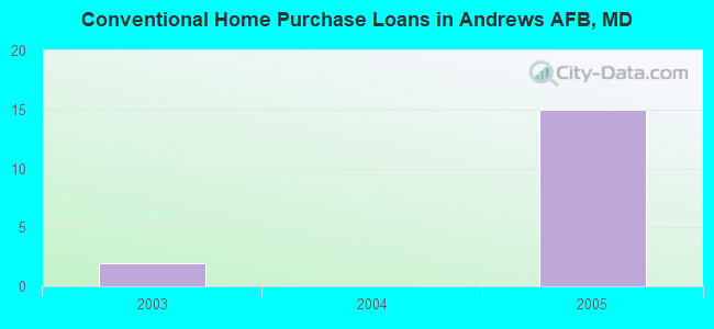
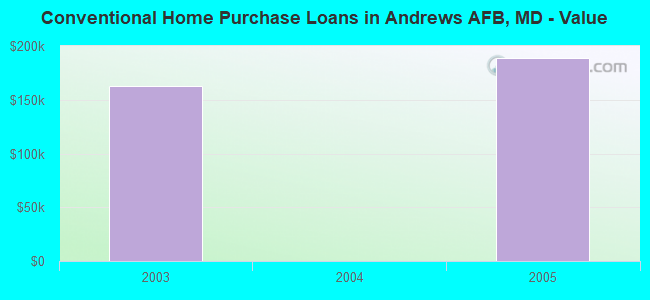
| Private Mortgage Insurance Companies Aggregated Statistics For Year 2003 (Based on 1 full tract) | ||
| A) Conventional Home Purchase Loans | ||
|---|---|---|
| Number | Average Value | |
| LOANS ORIGINATED | 0 | $0 |
| APPLICATIONS APPROVED, NOT ACCEPTED | 1 | $388,810 |
| APPLICATIONS DENIED | 0 | $0 |
| APPLICATIONS WITHDRAWN | 0 | $0 |
| FILES CLOSED FOR INCOMPLETENESS | 0 | $0 |
Detailed PMIC statistics for the following Tracts: 8011.04
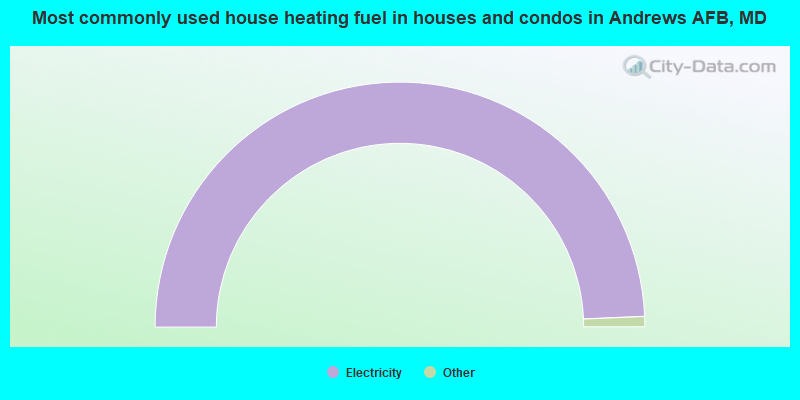
- 100.0%Electricity
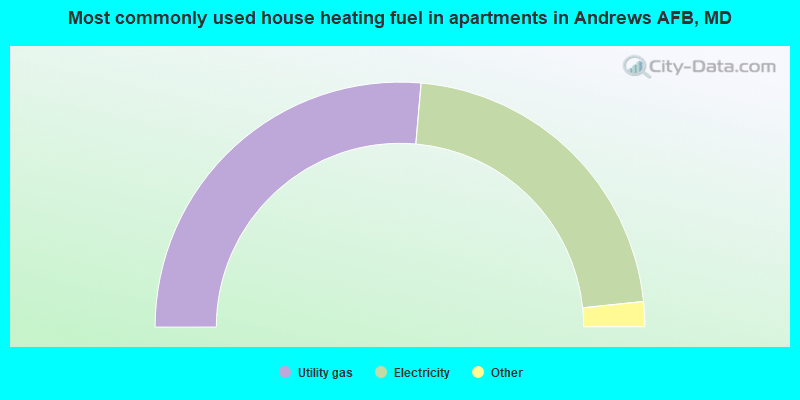
- 52.8%Utility gas
- 44.0%Electricity
- 1.9%No fuel used
- 1.3%Bottled, tank, or LP gas
Andrews AFB compared to Maryland state average:
- Median house value significantly below state average.
- Unemployed percentage significantly below state average.
- Black race population percentage significantly below state average.
- Hispanic race population percentage below state average.
- Median age significantly below state average.
- Foreign-born population percentage significantly below state average.
- Renting percentage significantly above state average.
- Length of stay since moving in significantly below state average.
- House age below state average.
Andrews AFB on our top lists:
- #2 on the list of "Top 101 cities with the largest percentage of people in wards in military hospitals for patients who have no usual home elsewhere (population 1,000+)"
- #9 on the list of "Top 101 cities with the largest percentage of people in military transient quarters for temporary residents (population 1,000+)"
- #35 on the list of "Top 101 cities with the smallest percentage of one, detached housing units in structures (2,000+ housing units)"
- #39 on the list of "Top 100 cities with declining populations from 2000 to 2014"
- #59 on the list of "Top 100 cities with highest percentage of renters"
- #75 on the list of "Top 101 cities with the largest percentage of people in military barracks, etc. (population 1,000+)"
- #94 on the list of "Top 101 larger cities with the lowest real estate taxes percentage (population 50,000+)"
- #4 (20762) on the list of "Top 101 zip codes with the largest percentage of returns reporting salary or wage in 2012 (pop 5,000+)"
- #7 (20762) on the list of "Top 101 zip codes with the lowest 2012 average reported profit/loss from business (pop 5,000+)"
- #13 (20762) on the list of "Top 101 zip codes with the smallest percentage of taxpayers reporting profit/loss from business in 2012 (pop 5,000+)"
- #17 (20762) on the list of "Top 101 zip codes with the smallest percentage of taxpayers using paid preparers for 2012 taxes (pop 5,000+)"
- #5 on the list of "Top 101 counties with highest percentage of residents voting for Obama (Democrat) in the 2012 Presidential Election"
- #12 on the list of "Top 101 counties with the highest number of infant deaths per 1000 residents 2007-2013 (pop. 50,000+)"
- #13 on the list of "Top 101 counties with the highest average weight of females"
- #14 on the list of "Top 101 counties with the highest Nitrogen Dioxide air pollution readings in 2012 (ppm)"
- #14 on the list of "Top 101 counties with the most Black Protestant adherents"
State forum archive: