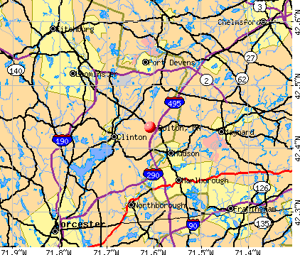
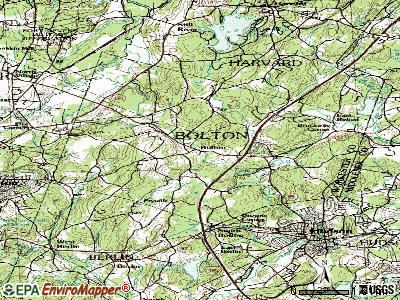
Bolton, Massachusetts
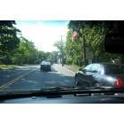
Bolton: Route 117 in the center of Bolton
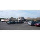
Bolton: Nashoba Regional High School (Rt. 117 & Green Rd)
- add
your
Submit your own pictures of this town and show them to the world
- OSM Map
- General Map
- Google Map
- MSN Map
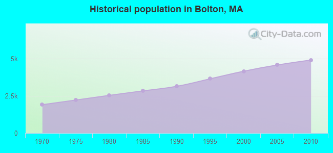
Population change since 2000: +18.1%
 |
| Males: 2,424 | |
| Females: 2,473 |
| Median resident age: | 42.8 years |
| Massachusetts median age: | 39.2 years |
Zip codes: 01740.
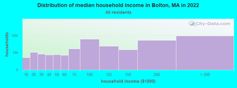
| Bolton: | $185,218 |
| MA: | $94,488 |
Estimated per capita income in 2022: $82,948 (it was $42,542 in 2000)
Bolton town income, earnings, and wages data
Estimated median house or condo value in 2022: $953,570 (it was $345,300 in 2000)
| Bolton: | $953,570 |
| MA: | $534,700 |
Mean prices in 2022: all housing units: $419,164; detached houses: $447,621; townhouses or other attached units: $343,592; in 2-unit structures: $323,295; in 3-to-4-unit structures: $332,295; in 5-or-more-unit structures: $232,758; mobile homes: $113,885
Detailed information about poverty and poor residents in Bolton, MA


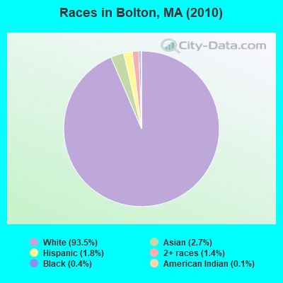
- 4,57793.5%White alone
- 1302.7%Asian alone
- 871.8%Hispanic
- 701.4%Two or more races
- 220.4%Black alone
- 70.1%American Indian alone
- 30.06%Other race alone
- 10.02%Native Hawaiian and Other
Pacific Islander alone
Races in Bolton detailed stats: ancestries, foreign born residents, place of birth
According to our research of Massachusetts and other state lists, there were 2 registered sex offenders living in Bolton, Massachusetts as of April 30, 2024.
The ratio of all residents to sex offenders in Bolton is 2,449 to 1.
The ratio of registered sex offenders to all residents in this city is lower than the state average.
Type |
2009 |
2010 |
2011 |
2012 |
2013 |
2014 |
2015 |
2016 |
2017 |
2018 |
2019 |
2020 |
2021 |
2022 |
|---|---|---|---|---|---|---|---|---|---|---|---|---|---|---|
| Murders (per 100,000) | 0 (0.0) | 0 (0.0) | 0 (0.0) | 0 (0.0) | 0 (0.0) | 0 (0.0) | 0 (0.0) | 0 (0.0) | 0 (0.0) | 0 (0.0) | 0 (0.0) | 0 (0.0) | 0 (0.0) | 0 (0.0) |
| Rapes (per 100,000) | 2 (43.9) | 2 (40.8) | 0 (0.0) | 1 (20.2) | 0 (0.0) | 1 (19.5) | 2 (38.6) | 1 (19.2) | 0 (0.0) | 0 (0.0) | 0 (0.0) | 0 (0.0) | 0 (0.0) | 0 (0.0) |
| Robberies (per 100,000) | 1 (21.9) | 0 (0.0) | 1 (20.3) | 0 (0.0) | 2 (39.5) | 0 (0.0) | 1 (19.3) | 0 (0.0) | 1 (19.0) | 0 (0.0) | 0 (0.0) | 0 (0.0) | 0 (0.0) | 0 (0.0) |
| Assaults (per 100,000) | 2 (43.9) | 4 (81.7) | 3 (60.9) | 9 (181.5) | 8 (158.1) | 8 (156.0) | 2 (38.6) | 5 (96.0) | 5 (94.8) | 0 (0.0) | 2 (37.1) | 5 (91.7) | 1 (17.9) | 5 (87.6) |
| Burglaries (per 100,000) | 11 (241.4) | 25 (510.5) | 14 (284.1) | 19 (383.1) | 18 (355.7) | 13 (253.5) | 13 (250.6) | 9 (172.7) | 5 (94.8) | 9 (168.7) | 2 (37.1) | 4 (73.3) | 8 (143.4) | 3 (52.5) |
| Thefts (per 100,000) | 27 (592.6) | 27 (551.4) | 30 (608.9) | 25 (504.1) | 25 (494.1) | 43 (838.5) | 34 (655.5) | 36 (691.0) | 29 (550.1) | 22 (412.4) | 23 (426.5) | 21 (385.0) | 18 (322.6) | 22 (385.3) |
| Auto thefts (per 100,000) | 2 (43.9) | 2 (40.8) | 1 (20.3) | 3 (60.5) | 1 (19.8) | 2 (39.0) | 2 (38.6) | 0 (0.0) | 2 (37.9) | 2 (37.5) | 0 (0.0) | 0 (0.0) | 1 (17.9) | 0 (0.0) |
| Arson (per 100,000) | 0 (0.0) | 0 (0.0) | 1 (20.3) | 0 (0.0) | 0 (0.0) | 0 (0.0) | 0 (0.0) | 2 (38.4) | 0 (0.0) | 0 (0.0) | 0 (0.0) | 0 (0.0) | 1 (17.9) | 0 (0.0) |
| City-Data.com crime index | 94.6 | 110.1 | 64.1 | 104.3 | 89.7 | 101.2 | 91.2 | 74.3 | 56.3 | 31.3 | 27.1 | 38.9 | 28.0 | 36.6 |
The City-Data.com crime index weighs serious crimes and violent crimes more heavily. Higher means more crime, U.S. average is 246.1. It adjusts for the number of visitors and daily workers commuting into cities.
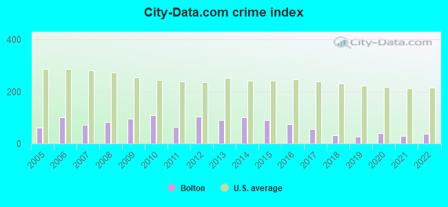
Crime rate in Bolton detailed stats: murders, rapes, robberies, assaults, burglaries, thefts, arson
Full-time law enforcement employees in 2021, including police officers: 13 (12 officers - 10 male; 2 female).
| Officers per 1,000 residents here: | 2.15 |
| Massachusetts average: | 2.53 |
 Recent articles from our blog. Our writers, many of them Ph.D. graduates or candidates, create easy-to-read articles on a wide variety of topics.

 | Another shooting in New Bedford (66 replies) |
| Harvard/Bolton commute to N Waltham (2 replies) |
| Stow or Bolton? (18 replies) |
| Worcester MA move considerations questions (63 replies) |
| Impending relocation from New Jersey and need guidance with complicate commute! (106 replies) |
| Raising a family in Stow? (6 replies) |
Latest news from Bolton, MA collected exclusively by city-data.com from local newspapers, TV, and radio stations
Ancestries: Irish (20.2%), English (20.0%), German (13.4%), Italian (12.2%), United States (7.7%), French (6.1%).
Current Local Time: EST time zone
Incorporated in 1738
Elevation: 387 feet
Land area: 19.9 square miles.
Population density: 246 people per square mile (very low).
244 residents are foreign born (3.1% Europe, 1.4% Asia, 0.9% North America).
| This town: | 5.9% |
| Massachusetts: | 12.2% |
| Bolton town: | 1.2% ($4,092) |
| Massachusetts: | 1.3% ($2,336) |
Nearest city with pop. 50,000+: Framingham, MA  (13.4 miles , pop. 66,910).
Nearest city with pop. 200,000+: Boston, MA (27.9 miles , pop. 589,141).
Nearest city with pop. 1,000,000+: Bronx, NY (160.5 miles , pop. 1,332,650).
Nearest cities:
), ), ), )Latitude: 42.44 N, Longitude: 71.61 W
Area code: 978

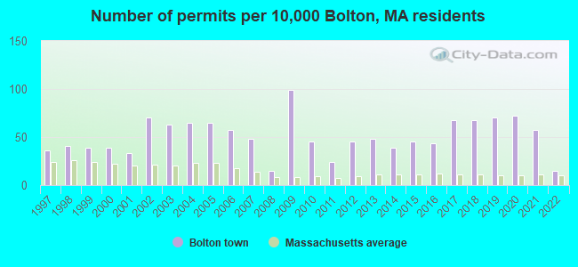
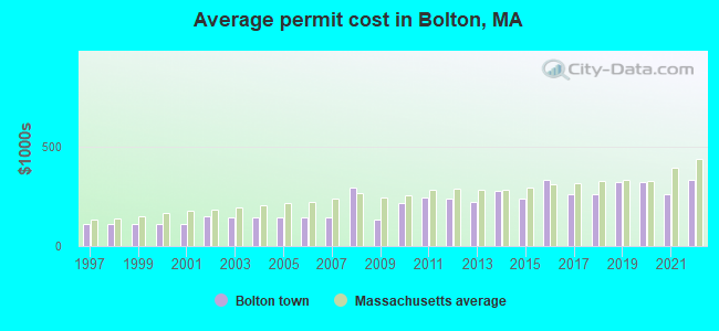
Single-family new house construction building permits:
- 2022: 6 buildings, average cost: $332,900
- 2021: 24 buildings, average cost: $260,000
- 2020: 30 buildings, average cost: $322,300
- 2019: 29 buildings, average cost: $322,300
- 2018: 28 buildings, average cost: $259,200
- 2017: 28 buildings, average cost: $259,200
- 2016: 18 buildings, average cost: $330,900
- 2015: 19 buildings, average cost: $236,700
- 2014: 16 buildings, average cost: $274,400
- 2013: 20 buildings, average cost: $220,900
- 2012: 19 buildings, average cost: $236,800
- 2011: 10 buildings, average cost: $243,200
- 2010: 19 buildings, average cost: $214,900
- 2009: 41 buildings, average cost: $135,200
- 2008: 6 buildings, average cost: $291,700
- 2007: 20 buildings, average cost: $144,300
- 2006: 24 buildings, average cost: $144,300
- 2005: 27 buildings, average cost: $144,300
- 2004: 27 buildings, average cost: $144,300
- 2003: 26 buildings, average cost: $143,100
- 2002: 29 buildings, average cost: $147,500
- 2001: 14 buildings, average cost: $109,700
- 2000: 16 buildings, average cost: $109,700
- 1999: 16 buildings, average cost: $109,700
- 1998: 17 buildings, average cost: $109,700
- 1997: 15 buildings, average cost: $109,700
| Here: | 2.6% |
| Massachusetts: | 3.5% |
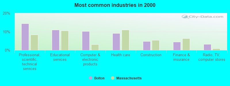
- Professional, scientific, technical services (14.4%)
- Educational services (11.0%)
- Computer & electronic products (10.3%)
- Health care (9.1%)
- Construction (4.8%)
- Finance & insurance (4.5%)
- Radio, TV, computer stores (3.3%)
- Professional, scientific, technical services (16.5%)
- Computer & electronic products (15.5%)
- Construction (7.8%)
- Educational services (6.0%)
- Health care (5.4%)
- Radio, TV, computer stores (4.4%)
- Finance & insurance (3.5%)
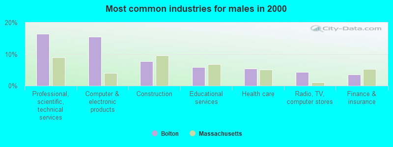
- Educational services (17.3%)
- Health care (13.8%)
- Professional, scientific, technical services (11.8%)
- Finance & insurance (5.6%)
- Public administration (4.0%)
- Computer & electronic products (3.7%)
- Social assistance (3.4%)
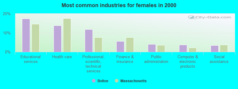
- Other management occupations, except farmers and farm managers (9.6%)
- Computer specialists (9.3%)
- Engineers (6.4%)
- Other sales and related occupations, including supervisors (4.4%)
- Sales representatives, services, wholesale and manufacturing (4.0%)
- Top executives (3.8%)
- Postsecondary teachers (3.3%)
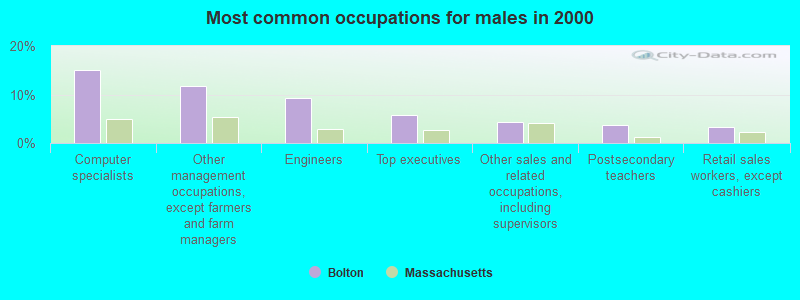
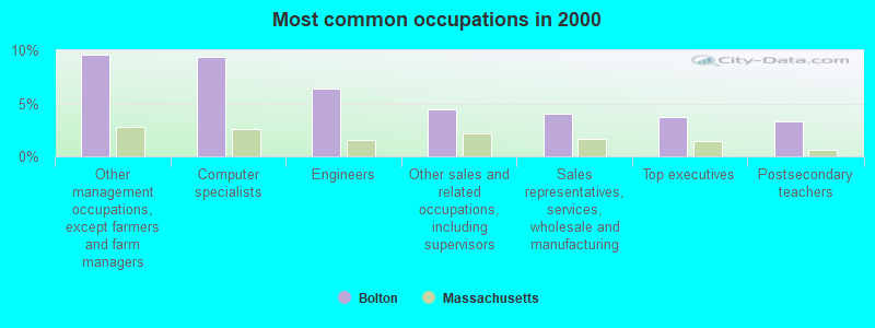
- Computer specialists (15.1%)
- Other management occupations, except farmers and farm managers (11.8%)
- Engineers (9.3%)
- Top executives (5.7%)
- Other sales and related occupations, including supervisors (4.2%)
- Postsecondary teachers (3.8%)
- Retail sales workers, except cashiers (3.4%)
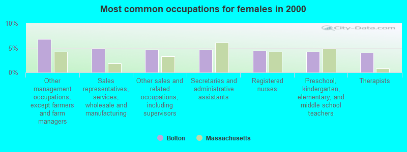
- Other management occupations, except farmers and farm managers (6.8%)
- Sales representatives, services, wholesale and manufacturing (4.8%)
- Other sales and related occupations, including supervisors (4.6%)
- Secretaries and administrative assistants (4.6%)
- Registered nurses (4.4%)
- Preschool, kindergarten, elementary, and middle school teachers (4.2%)
- Therapists (4.0%)
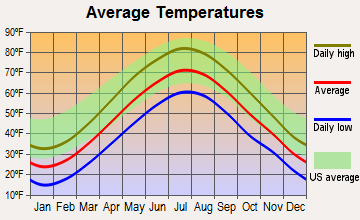
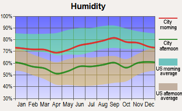
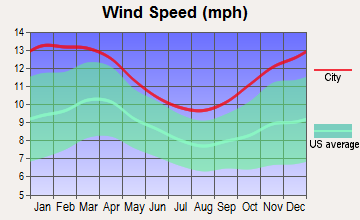
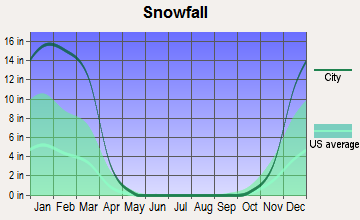
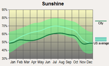
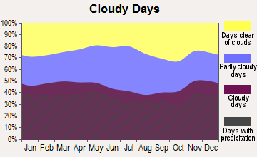
Average climate in Bolton, Massachusetts
Based on data reported by over 4,000 weather stations
(lower is better)
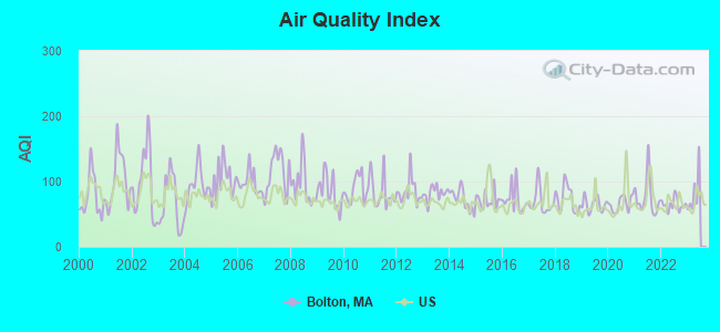
Air Quality Index (AQI) level in 2022 was 64.6. This is about average.
| City: | 64.6 |
| U.S.: | 72.6 |
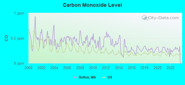
Carbon Monoxide (CO) [ppm] level in 2022 was 0.259. This is about average. Closest monitor was 15.1 miles away from the city center.
| City: | 0.259 |
| U.S.: | 0.251 |
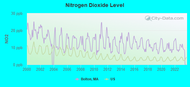
Nitrogen Dioxide (NO2) [ppb] level in 2022 was 10.6. This is significantly worse than average. Closest monitor was 7.2 miles away from the city center.
| City: | 10.6 |
| U.S.: | 5.1 |
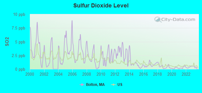
Sulfur Dioxide (SO2) [ppb] level in 2022 was 0.370. This is significantly better than average. Closest monitor was 7.2 miles away from the city center.
| City: | 0.370 |
| U.S.: | 1.515 |
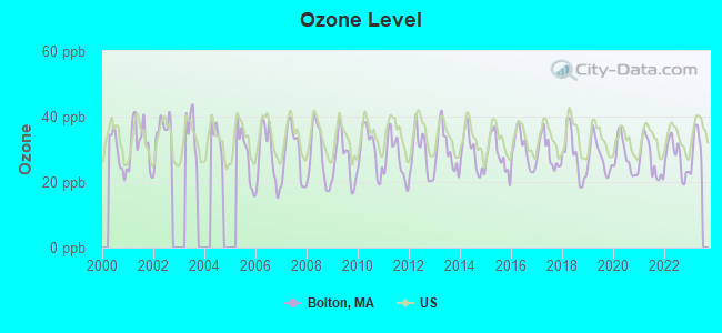
Ozone [ppb] level in 2022 was 27.5. This is better than average. Closest monitor was 12.8 miles away from the city center.
| City: | 27.5 |
| U.S.: | 33.3 |
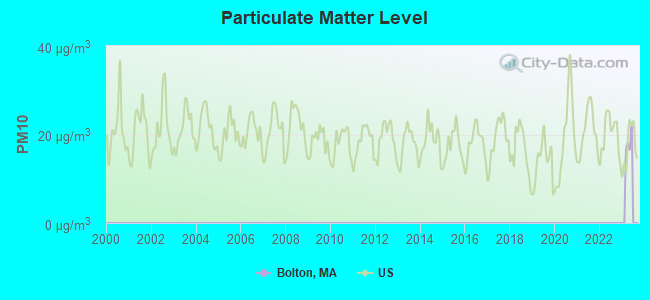
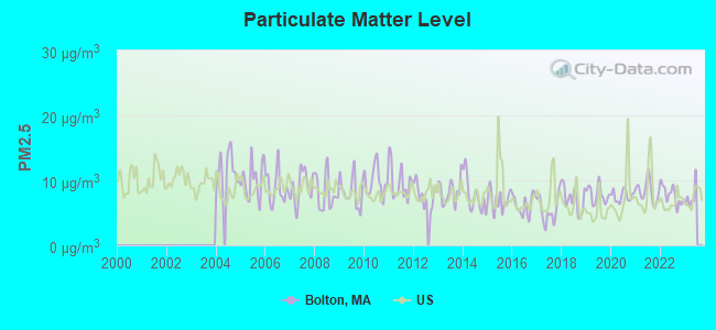
Particulate Matter (PM2.5) [µg/m3] level in 2022 was 7.76. This is about average. Closest monitor was 6.8 miles away from the city center.
| City: | 7.76 |
| U.S.: | 8.11 |
Tornado activity:
Bolton-area historical tornado activity is slightly above Massachusetts state average. It is 24% smaller than the overall U.S. average.
On 6/9/1953, a category F4 (max. wind speeds 207-260 mph) tornado 10.6 miles away from the Bolton town center killed 90 people and injured 1228 people and caused between $50,000,000 and $500,000,000 in damages.
On 10/3/1970, a category F3 (max. wind speeds 158-206 mph) tornado 10.3 miles away from the town center killed one person and caused between $50,000 and $500,000 in damages.
Earthquake activity:
Bolton-area historical earthquake activity is significantly above Massachusetts state average. It is 72% smaller than the overall U.S. average.On 10/7/1983 at 10:18:46, a magnitude 5.3 (5.1 MB, 5.3 LG, 5.1 ML, Class: Moderate, Intensity: VI - VII) earthquake occurred 173.0 miles away from Bolton center
On 4/20/2002 at 10:50:47, a magnitude 5.3 (5.3 ML, Depth: 3.0 mi) earthquake occurred 177.6 miles away from Bolton center
On 4/20/2002 at 10:50:47, a magnitude 5.2 (5.2 MB, 4.2 MS, 5.2 MW, 5.0 MW) earthquake occurred 176.8 miles away from Bolton center
On 1/19/1982 at 00:14:42, a magnitude 4.7 (4.5 MB, 4.7 MD, 4.5 LG, Class: Light, Intensity: IV - V) earthquake occurred 73.5 miles away from the city center
On 10/16/2012 at 23:12:25, a magnitude 4.7 (4.7 ML, Depth: 10.0 mi) earthquake occurred 93.7 miles away from the city center
On 8/22/1992 at 12:20:32, a magnitude 4.8 (4.8 MB, 3.8 MS, 4.7 LG, Depth: 6.2 mi) earthquake occurred 240.2 miles away from the city center
Magnitude types: regional Lg-wave magnitude (LG), body-wave magnitude (MB), duration magnitude (MD), local magnitude (ML), surface-wave magnitude (MS), moment magnitude (MW)
Natural disasters:
The number of natural disasters in Worcester County (27) is a lot greater than the US average (15).Major Disasters (Presidential) Declared: 15
Emergencies Declared: 12
Causes of natural disasters: Floods: 9, Storms: 8, Hurricanes: 6, Snowstorms: 5, Winter Storms: 4, Blizzards: 2, Snows: 2, Fire: 1, Heavy Rain: 1, Snowfall: 1, Tornado: 1, Wind: 1 (Note: some incidents may be assigned to more than one category).
Hospitals and medical centers near Bolton:
- HUDSON NURSING HOME - OLD (Nursing Home, about 4 miles away; HUDSON, MA)
- KINDRED NURSING AND REHABILITATION-RIVER TERRACE (Nursing Home, about 5 miles away; LANCASTER, MA)
- CLINTON HOSPITAL ASSOCIATION Acute Care Hospitals (about 5 miles away; CLINTON, MA)
- CLINTON MANOR NURSING HOME (Nursing Home, about 5 miles away; CLINTON, MA)
- BRAEMOOR EAST OF MARLBORO (Nursing Home, about 7 miles away; MARLBOROUGH, MA)
- KINDRED TRANSITIONAL CARE AND REHAB-MARLBOROUGH (Nursing Home, about 7 miles away; MARLBOROUGH, MA)
- MARLBOROUGH HOSPITAL Acute Care Hospitals (about 7 miles away; MARLBOROUGH, MA)
Amtrak stations near Bolton:
- 15 miles: FRAMINGHAM (443 WAVERLY ST.) . Services: public payphones, snack bar, paid short-term parking, taxi stand, public transit connection.
- 16 miles: WORCESTER (WORCHESTER, 45 SHREWSBURY ST.) . Services: ticket office, fully wheelchair accessible, enclosed waiting area, public restrooms, public payphones, vending machines, free short-term parking, free long-term parking, call for taxi service, public transit connection.
Colleges/universities with over 2000 students nearest to Bolton:
- Quinsigamond Community College (about 13 miles; Worcester, MA; Full-time enrollment: 5,877)
- Framingham State University (about 14 miles; Framingham, MA; FT enrollment: 5,743)
- Fitchburg State University (about 14 miles; Fitchburg, MA; FT enrollment: 5,010)
- Assumption College (about 15 miles; Worcester, MA; FT enrollment: 2,580)
- Worcester Polytechnic Institute (about 16 miles; Worcester, MA; FT enrollment: 3,930)
- Worcester State University (about 17 miles; Worcester, MA; FT enrollment: 5,426)
- Clark University (about 17 miles; Worcester, MA; FT enrollment: 3,687)
Public high school in Bolton:
- NASHOBA REGIONAL (Students: 902, Location: 12 GREEN ROAD, Grades: 9-12)
Public elementary/middle school in Bolton:
- FLORENCE SAWYER SCHOOL (Students: 808, Location: 100 MECHANIC STREET, Grades: PK-8)
Points of interest:
Notable locations in Bolton: Bolton Spring Farm (A), Nicewicz Farm (B), Schartner Farm (C), Camp Resolute (D), Camp Virginia (E), Runaway Brook Country Club (F), International Golf Club (G), Bolton Fire Department (H), Nashoba Winery (I), Bolton Town Hall (J). Display/hide their locations on the map
Churches in Bolton include: Saint Francis Xavier Church (A), Trinity Church (B), Bolton Federated Church (C). Display/hide their locations on the map
Cemeteries: West Cemetery (1), Eastwood Cemetery (2), Bolton Pan Cemetery (3), South Cemetery (4), Friends Cemetery (5), South Cemetery (6), Bolton Pan Cemetery (7). Display/hide their locations on the map
Lakes, reservoirs, and swamps: Welch Pond (A), Little Pond (B), West Pond (C), Delaney Pond (D), Sunk Meadow (E). Display/hide their locations on the map
Streams, rivers, and creeks: Mill Brook (A). Display/hide its location on the map
Park in Bolton: Bolton Flats Wildlife Management Area (1). Display/hide its location on the map
Birthplace of: Wilbert Robinson - Baseball player and coach, Amos Nourse - Politician, Frederick A. Sawyer - Politician.
Drinking water stations with addresses in Bolton and their reported violations in the past:
BOLTON COUNTRY MANOR (Population served: 60, Groundwater):Past monitoring violations:
- 2 routine major monitoring violations
- 4 regular monitoring violations
| This town: | 2.9 people |
| Massachusetts: | 2.5 people |
| This town: | 83.3% |
| Whole state: | 63.0% |
| This town: | 5.4% |
| Whole state: | 7.0% |
Likely homosexual households (counted as self-reported same-sex unmarried-partner households)
- Lesbian couples: 1.0% of all households
- Gay men: 0.5% of all households
| This town: | 1.8% |
| Whole state: | 9.3% |
| This town: | 0.6% |
| Whole state: | 4.4% |
Banks with branches in Bolton (2011 data):
- Clinton Savings Bank: Nashoba Regional High School Branch at 563 Main St., branch established on 1989/04/25; Bolton Branch at 563 Main Street, branch established on 1981/04/01. Info updated 2012/04/03: Bank assets: $479.5 mil, Deposits: $362.7 mil, headquarters in Clinton, MA, positive income, Mortgage Lending Specialization, 7 total offices, Holding Company: Clinton Financial Services, Mhc
For population 15 years and over in Bolton:
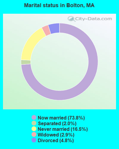
- Never married: 16.5%
- Now married: 73.8%
- Separated: 2.0%
- Widowed: 2.9%
- Divorced: 4.8%
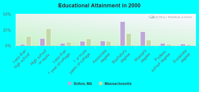
For population 25 years and over in Bolton:
- High school or higher: 97.6%
- Bachelor's degree or higher: 67.3%
- Graduate or professional degree: 28.9%
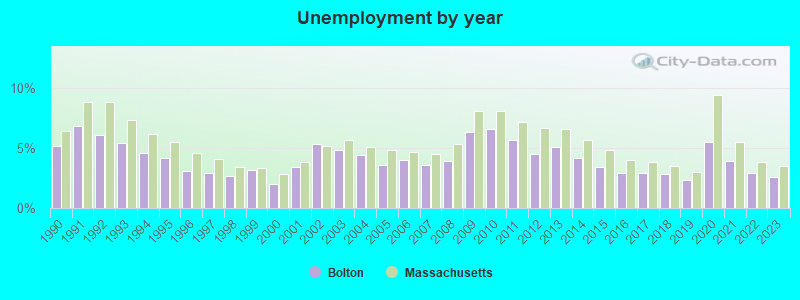
- Unemployed: 3.4%
- Mean travel time to work (commute): 31.1 minutes
| Here: | 8.2 |
| Massachusetts average: | 13.1 |


Graphs represent county-level data. Detailed 2008 Election Results
Religion statistics for Bolton, MA (based on Worcester County data)


| Religion | Adherents | Congregations |
|---|---|---|
| Catholic | 306,925 | 118 |
| Mainline Protestant | 43,326 | 171 |
| Evangelical Protestant | 37,511 | 203 |
| Other | 18,931 | 69 |
| Orthodox | 7,935 | 15 |
| Black Protestant | 497 | 6 |
| None | 383,427 | - |
Food Environment Statistics:
| Worcester County: | 1.73 / 10,000 pop. |
| Massachusetts: | 1.98 / 10,000 pop. |
| Here: | 0.05 / 10,000 pop. |
| Massachusetts: | 0.05 / 10,000 pop. |
| This county: | 1.79 / 10,000 pop. |
| State: | 2.22 / 10,000 pop. |
| This county: | 2.22 / 10,000 pop. |
| Massachusetts: | 1.77 / 10,000 pop. |
| This county: | 7.27 / 10,000 pop. |
| Massachusetts: | 8.76 / 10,000 pop. |
| Worcester County: | 8.0% |
| State: | 8.1% |
| This county: | 24.0% |
| Massachusetts: | 22.5% |
| This county: | 16.6% |
| Massachusetts: | 16.5% |
4.71% of this county's 2021 resident taxpayers lived in other counties in 2020 ($76,229 average adjusted gross income)
| Here: | 4.71% |
| Massachusetts average: | 6.35% |
0.02% of residents moved from foreign countries ($100 average AGI)
Worcester County: 0.02% Massachusetts average: 0.01%
Top counties from which taxpayers relocated into this county between 2020 and 2021:
| from Middlesex County, MA | |
| from Norfolk County, MA | |
| from Suffolk County, MA |
4.84% of this county's 2020 resident taxpayers moved to other counties in 2021 ($87,252 average adjusted gross income)
| Here: | 4.84% |
| Massachusetts average: | 7.18% |
0.03% of residents moved to foreign countries ($199 average AGI)
Worcester County: 0.03% Massachusetts average: 0.02%
Top counties to which taxpayers relocated from this county between 2020 and 2021:
| to Middlesex County, MA | |
| to Norfolk County, MA | |
| to Suffolk County, MA |
Businesses in Bolton, MA
- Subway: 1
Strongest AM radio stations in Bolton:
- WAZN (1470 AM; 7 kW; MARLBOROUGH, MA; Owner: MULTICULTURAL RADIO BROADCASTING, INC.)
- WKOX (1200 AM; 50 kW; FRAMINGHAM, MA; Owner: CAPSTAR TX LIMITED PARTNERSHIP)
- WBIX (1060 AM; 40 kW; NATICK, MA; Owner: LANGER BROADCASTING CORPORATION)
- WRKO (680 AM; 50 kW; BOSTON, MA; Owner: ENTERCOM BOSTON LICENSE, LLC)
- WCRN (830 AM; 50 kW; WORCESTER, MA; Owner: CARTER BROADCASTING CORPORATION)
- WEEI (850 AM; 50 kW; BOSTON, MA; Owner: ENTERCOM BOSTON LICENSE, LLC)
- WAMG (890 AM; 25 kW; DEDHAM, MA; Owner: MEGA COMMUNICATIONS OF DEDHAM LICENSEE, LLC)
- WWZN (1510 AM; 50 kW; BOSTON, MA; Owner: ROSE CITY RADIO CORPORATION)
- WRCA (1330 AM; 25 kW; WALTHAM, MA; Owner: WRCA LICENSE, LLC)
- WTAG (580 AM; 5 kW; WORCESTER, MA; Owner: CAPSTAR TX LIMITED PARTNERSHIP)
- WBNW (1120 AM; 5 kW; CONCORD, MA; Owner: MONEY MATTERS RADIO, INC.)
- WALE (990 AM; 50 kW; GREENVILLE, RI; Owner: NORTH AMERICAN BROADCASTING CO., INC.)
- WVNE (760 AM; daytime; 25 kW; LEICESTER, MA; Owner: BLOUNT MASSCOM, INC.)
Strongest FM radio stations in Bolton:
- WXLO (104.5 FM; FITCHBURG, MA; Owner: CITADEL BROADCASTING COMPANY)
- WAAF (107.3 FM; WORCESTER, MA; Owner: ENTERCOM BOSTON LICENSE, LLC)
- WBMX (98.5 FM; BOSTON, MA; Owner: INFINITY RADIO OPERATIONS INC.)
- WSRS (96.1 FM; WORCESTER, MA; Owner: CAPSTAR TX LIMITED PARTNERSHIP)
- WJMN (94.5 FM; BOSTON, MA; Owner: AMFM RADIO LICENSES, L.L.C.)
- WCRB (102.5 FM; WALTHAM, MA; Owner: CHARLES RIVER BROADCASTING WCRB LICE)
- WTKK (96.9 FM; BOSTON, MA; Owner: GREATER BOSTON RADIO, INC.)
- WROR-FM (105.7 FM; FRAMINGHAM, MA; Owner: GREATER BOSTON RADIO, INC.)
- WBOS (92.9 FM; BROOKLINE, MA; Owner: GREATER BOSTON RADIO, INC.)
- WGBH (89.7 FM; BOSTON, MA; Owner: WGBH EDUCATIONAL FOUNDATION)
- WBUR-FM (90.9 FM; BOSTON, MA; Owner: TRUSTEES OF BOSTON UNIVERSITY)
- WODS (103.3 FM; BOSTON, MA; Owner: INFINITY BROADCASTING OPERATIONS, INC.)
- WXKS-FM (107.9 FM; MEDFORD, MA; Owner: AMFM RADIO LICENSES, L.L.C.)
- WMJX (106.7 FM; BOSTON, MA; Owner: GREATER BOSTON RADIO, INC.)
- WFEX (92.1 FM; PETERBOROUGH, NH; Owner: FNX BROADCASTING OF NEW HAMPSHIRE LLC)
- WICN (90.5 FM; WORCESTER, MA; Owner: WICN PUBLIC RADIO, INC)
- WBCN (104.1 FM; BOSTON, MA; Owner: HEMISPHERE BROADCASTING CORPORATION)
- WZLX (100.7 FM; BOSTON, MA; Owner: INFINITY BROADCASTING CORPORATION OF BOSTON)
- WKLB-FM (99.5 FM; LOWELL, MA; Owner: GREATER BOSTON RADIO, INC.)
- W267AI (101.3 FM; BOSTON, MA; Owner: MCC BROADCASTING COMPANY, INC.)
TV broadcast stations around Bolton:
- WUTF (Channel 66; MARLBOROUGH, MA; Owner: TELEFUTURA BOSTON LLC)
- WUNI (Channel 27; WORCESTER, MA; Owner: ENTRAVISION HOLDINGS, LLC)
- WCVB-TV (Channel 5; BOSTON, MA; Owner: WCVB HEARST-ARGYLE TV, INC.)
- WGBH-TV (Channel 2; BOSTON, MA; Owner: WGBH EDUCATIONAL FOUNDATION)
- WHDH-TV (Channel 7; BOSTON, MA; Owner: WHDH-TV)
- WMFP (Channel 62; LAWRENCE, MA; Owner: WSAH LICENSE, INC.)
- WBZ-TV (Channel 4; BOSTON, MA; Owner: VIACOM INC.)
- WGBX-TV (Channel 44; BOSTON, MA; Owner: WGBH EDUCATIONAL FOUNDATION)
- WSBK-TV (Channel 38; BOSTON, MA; Owner: VIACOM INC.)
- WLVI-TV (Channel 56; CAMBRIDGE, MA; Owner: WLVI, INC.)
- WFXT (Channel 25; BOSTON, MA; Owner: FOX TELEVISION STATIONS INC.)
- W40BO (Channel 40; BOSTON, MA; Owner: PAXSON COMMUNICATIONS LPTV, INC.)
- WBPX (Channel 68; BOSTON, MA; Owner: PAXSON BOSTON-68 LICENSE, INC.)
- WTMU-LP (Channel 32; BOSTON, MA; Owner: ZGS BOSTON, INC.)
- WYDN (Channel 48; WORCESTER, MA; Owner: EDUCATIONAL PUBLIC TV CORPORATION)
- WCEA-LP (Channel 58; BOSTON, MA; Owner: CHANNEL 19 TV CORPORATION)
- WFXZ-CA (Channel 24; BOSTON, MA; Owner: BOSTON BROADCASTING CORP.)
- WWDP (Channel 46; NORWELL, MA; Owner: NORWELL TELEVISION, LLC)
- WNDS (Channel 50; DERRY, NH; Owner: CTV OF DERRY, INC)
- WNAC-TV (Channel 64; PROVIDENCE, RI; Owner: WNAC, LLC)
- WPRI-TV (Channel 12; PROVIDENCE, RI; Owner: TVL BROADCASTING OF RHODE ISLAND, LLC)
- WCRN-LP (Channel 34; LEICESTER, MA; Owner: CARTER BROADCASTING CORPORATION)
- National Bridge Inventory (NBI) Statistics
- 8Number of bridges
- 92ft / 28.3mTotal length
- $24,668,000Total costs
- 318,577Total average daily traffic
- 24,528Total average daily truck traffic
FCC Registered Antenna Towers:
3- Richard Byrne, 96 Hudson Road (Lat: 42.422778 Lon: -71.582333), Type: 41.4, Overall height: 39.6 m, Registrant: Towerco Assets LLC, Shart@towerco.Com, , Cary, Phone: (919) 469-5559
- Richard Byrne, 96 Hudson Road (Lat: 42.422778 Lon: -71.582333), Type: 41.4, Overall height: 39.6 m, Registrant: Towerco Assets LLC, Afry@towerco.Com, , Cary, Phone: (919) 653-5710
- Edward G Roach, 96 Hudson Road (Lat: 42.422778 Lon: -71.582333), Type: 41.4, Structure height: 25027 m, Overall height: 39.6 m, Registrant: Sba 2012 Tc Assets, LLC, Eroach@sbasite.Com, , Boca -Raton, Phone: (561) 995-7670
FCC Registered Private Land Mobile Towers:
1- Near (Lat: 42.437028 Lon: -71.603667), Type: Tower, Structure height: 37 m, Call Sign: WPLA719,
Assigned Frequencies: 862.037 MHz, 862.062 MHz, 862.087 MHz, 862.112 MHz, 862.137 MHz, 862.162 MHz, 862.187 MHz, 862.212 MHz, 862.237 MHz, 862.262 MHz... (+148 more), Grant Date: 02/28/2012, Expiration Date: 02/06/2022, Cancellation Date: 09/12/2019, Registrant: Sprint Corporation, 12502 Sunrise Valley Drive, M/S: Varesa-0209, Reston, VA 20196, Phone: (800) 572-8256, Fax: (703) 433-4483, Email:
FCC Registered Broadcast Land Mobile Towers:
4- Lat: 43.333667 Lon: -71.714222, Call Sign: WPUU921,
Assigned Frequencies: 468.912 MHz, Grant Date: 04/17/2012, Expiration Date: 05/07/2022, Cancellation Date: 07/09/2022, Certifier: Ronald A Parker, Registrant: Business Radio Licensing, 30251 Golden Lantern, Suite E #501, Laguna Niguel, CA 92677, Phone: (949) 348-8510, Fax: (949) 348-8514, Email:
- 35 West Berlin Rd (Lat: 42.429722 Lon: -71.636111), Type: Tower, Structure height: 30 m, Overall height: 32 m, Call Sign: WPUZ660,
Assigned Frequencies: 482.850 MHz, Grant Date: 06/03/2002, Expiration Date: 12/03/2002, Cancellation Date: 03/09/2003, Certifier: Michael W Slepetz, Registrant: Apco International, 351 N Williamson Blvd, Daytona Beach, FL 32114, Phone: (386) 322-2500, Fax: (386) 322-2502, Email:
- 35 West Berlin Rd (Lat: 42.429722 Lon: -71.636111), Type: Tower, Structure height: 30 m, Overall height: 32 m, Call Sign: WPUZ663,
Assigned Frequencies: 453.125 MHz, Grant Date: 06/03/2002, Expiration Date: 12/03/2002, Cancellation Date: 03/09/2003, Certifier: Michael W Slepetz, Registrant: Apco International, 351 N Williamson Blvd, Daytona Beach, FL 32119, Phone: (386) 322-2500, Fax: (386) 322-2502, Email:
- Lat: 42.432333 Lon: -71.608250, Call Sign: WQCZ994,
Assigned Frequencies: 451.412 MHz, 451.712 MHz, 456.412 MHz, 456.712 MHz, Grant Date: 07/05/2005, Expiration Date: 07/05/2015, Cancellation Date: 09/19/2015, Certifier: William Spratt, Registrant: Comtronics Corporation, 1230 Furnace Brook Parkway, Quincy, MA 02169, Phone: (617) 770-0212, Fax: (617) 770-0429, Email:
FCC Registered Microwave Towers:
2- Bolton, Main St, Rte 117 (Lat: 42.428389 Lon: -71.596806), Type: Mast, Structure height: 45.7 m, Overall height: 46.9 m, Call Sign: WPOM830,
Assigned Frequencies: 10652.5 MHz, Grant Date: 02/09/2010, Expiration Date: 03/13/2020, Cancellation Date: 08/18/2016, Certifier: Carol L Tacker, Registrant: At&t Mobility LLC, 1120 20th Street, Nw - Suite 1000, Washington, DC 20036, Phone: (202) 457-2055, Fax: (202) 457-3073, Email:
- Bolton, Lat: 42.460556 Lon: -71.598333, Call Sign: WRDQ376,
Assigned Frequencies: 956.281 MHz, Grant Date: 06/25/2019, Expiration Date: 06/25/2029, Certifier: Kevin A Bartlett, Registrant: Sensus, 450 N. Gallatin Avenue, Uniontown, PA 15401, Phone: (800) 638-3748, Fax: (800) 888-2403, Email:
FCC Registered Amateur Radio Licenses:
56 (See the full list of FCC Registered Amateur Radio Licenses in Bolton)FAA Registered Aircraft Manufacturers and Dealers:
1 (See the full list of FAA Registered Manufacturers and Dealers in Bolton)FAA Registered Aircraft:
8 (See the full list of FAA Registered Aircraft)2002 - 2018 National Fire Incident Reporting System (NFIRS) incidents
- Fire incident types reported to NFIRS in Bolton, MA
- 12339.2%Outside Fires
- 9831.2%Structure Fires
- 9028.7%Mobile Property/Vehicle Fires
- 31.0%Other
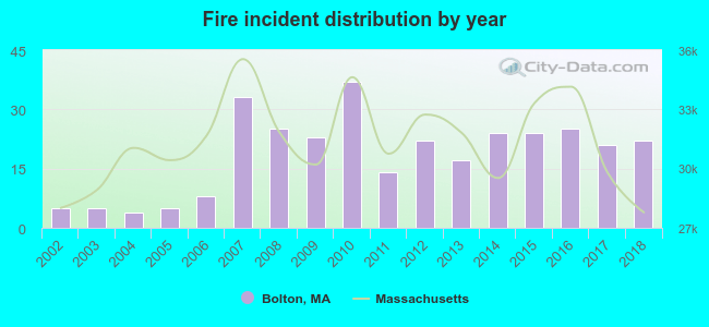 Based on the data from the years 2002 - 2018 the average number of fire incidents per year is 18. The highest number of reported fires - 37 took place in 2010, and the least - 4 in 2004. The data has an increasing trend.
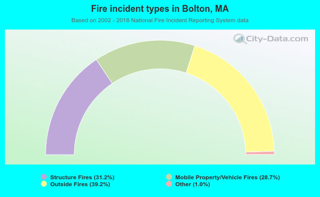 When looking into fire subcategories, the most reports belonged to: Outside Fires (39.2%), and Structure Fires (31.2%).
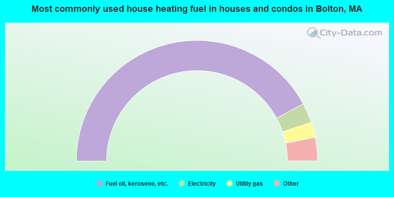
- 84.2%Fuel oil, kerosene, etc.
- 5.3%Electricity
- 4.1%Utility gas
- 3.1%Bottled, tank, or LP gas
- 2.7%Wood
- 0.5%Other fuel
- 81.9%Fuel oil, kerosene, etc.
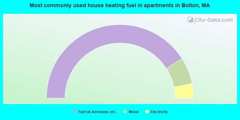
- 11.7%Wood
- 6.4%Electricity
Bolton compared to Massachusetts state average:
- Median household income above state average.
- Median house value above state average.
- Unemployed percentage significantly below state average.
- Black race population percentage significantly below state average.
- Hispanic race population percentage significantly below state average.
- Foreign-born population percentage significantly below state average.
- Renting percentage significantly below state average.
- Length of stay since moving in significantly above state average.
- Number of rooms per house significantly below state average.
- House age significantly below state average.
- Percentage of population with a bachelor's degree or higher above state average.

|
|
Total of 838 patent applications in 2008-2024.