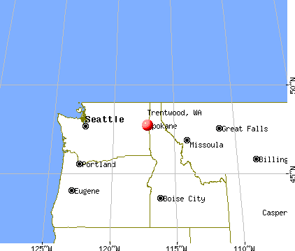
Trentwood, Washington
Submit your own pictures of this place and show them to the world
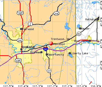
- OSM Map
- General Map
- Google Map
- MSN Map
| Males: 2,438 | |
| Females: 2,341 |
| Median resident age: | 33.6 years |
| Washington median age: | 35.3 years |
Zip codes: 99216.
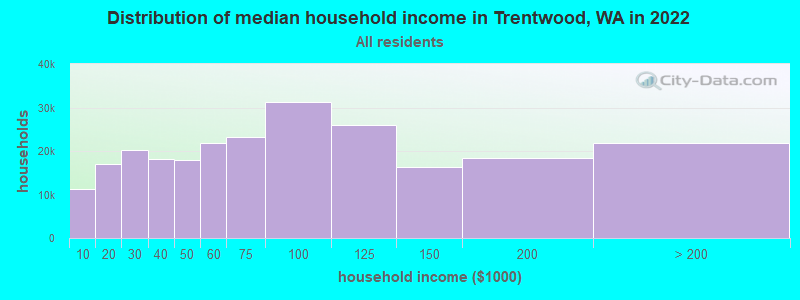
| Trentwood: | $76,142 |
| WA: | $91,306 |
Estimated per capita income in 2022: $34,513 (it was $16,566 in 2000)
Trentwood CDP income, earnings, and wages data
Estimated median house or condo value in 2022: $403,170 (it was $107,900 in 2000)
| Trentwood: | $403,170 |
| WA: | $569,500 |
Mean prices in 2022: all housing units: $457,076; detached houses: $470,103; townhouses or other attached units: $805,398; in 2-unit structures: $303,176; in 3-to-4-unit structures: $346,699; in 5-or-more-unit structures: $339,273; mobile homes: $178,924; occupied boats, rvs, vans, etc.: $32,360
Detailed information about poverty and poor residents in Trentwood, WA
Compare current foreclosures near Trentwood, WA:
| Photo | Address | Area | Beds / Baths | Price | Details |
|---|---|---|---|---|---|

|
#1
W Woodside Ave
Spokane, WA 99208
|
2,464 sq. feet
|
3 baths 3 beds |
$450,000
|
show details |

|
#2
E 5th Ave
Spokane, WA 99202
|
810 sq. feet
|
1 baths 2 beds |
show details | |

|
#3
E Dalton Ave
Spokane, WA 99207
|
1,104 sq. feet
|
2 baths 3 beds |
show details | |

|
#4
E Whitman Ct
Spokane, WA 99206
|
1,272 sq. feet
|
2 baths 3 beds |
show details | |

|
#5
N Elizabeth St
Spokane, WA 99208
|
1,908 sq. feet
|
2 baths 4 beds |
show details | |

|
#6
E Rowan Ave
Spokane, WA 99207
|
1,867 sq. feet
|
1 baths 3 beds |
show details | |

|
#7
E Lyons Ave
Spokane, WA 99208
|
2,364 sq. feet
|
1 baths 3 beds |
show details | |

|
#8
E 4th Ave
Spokane, WA 99216
|
1,176 sq. feet
|
1 baths 3 beds |
show details | |

|
#9
E 4th Ave
Spokane, WA 99216
|
2,404 sq. feet
|
2 baths 3 beds |
show details | |

|
#10
E Nina Ave
Spokane, WA 99202
|
2,992 sq. feet
|
1 baths 4 beds |
show details |
| Photo | Address | Area | Beds / Baths | Price | Details |
|---|---|---|---|---|---|

|
#11
N K St
Spokane, WA 99205
|
1,200 sq. feet
|
1 baths 2 beds |
show details | |

|
#12
E 46th Ave
Spokane, WA 99206
|
1,040 sq. feet
|
2 baths 2 beds |
show details | |

|
#13
E Thurston Ave
Spokane, WA 99223
|
2,392 sq. feet
|
3 baths 4 beds |
show details | |

|
#14
E Parkside Ln
Spokane, WA 99217
|
1,533 sq. feet
|
3 baths 5 beds |
show details | |

|
#15
N Alberta St
Spokane, WA 99208
|
1,244 sq. feet
|
3 baths 4 beds |
show details | |

|
#16
E Lacrosse Ave
Spokane, WA 99212
|
2,400 sq. feet
|
2 baths 4 beds |
show details | |

|
#17
N Willow Rd
Spokane, WA 99206
|
1,912 sq. feet
|
2 baths 3 beds |
show details | |

|
#18
N Stevens St
Spokane, WA 99205
|
986 sq. feet
|
1 baths 3 beds |
show details | |

|
#19
W Midway Ave
Post Falls, ID 83854
|
1,410 sq. feet
|
1 baths 3 beds |
show details | |

|
#20
W Maxwell Ave
Spokane, WA 99201
|
2,318 sq. feet
|
2 baths 4 beds |
show details |
| Photo | Address | Area | Beds / Baths | Price | Details |
|---|---|---|---|---|---|

|
#21
E Congress Ave
Spokane, WA 99223
|
1,732 sq. feet
|
2 baths 4 beds |
show details | |

|
#22
E 35th Ave
Spokane, WA 99203
|
4,592 sq. feet
|
2 baths 3 beds |
show details | |

|
#23
N Coleman Rd
Spokane, WA 99212
|
- sq. feet
|
2 baths 4 beds |
show details | |

|
#24
W 27th Ave
Spokane, WA 99224
|
3,206 sq. feet
|
2 baths 4 beds |
show details | |

|
#25
W Princeton Ave
Spokane, WA 99205
|
720 sq. feet
|
1 baths 2 beds |
show details | |

|
#26
E Wabash Ave
Spokane, WA 99207
|
1,810 sq. feet
|
2 baths 4 beds |
show details | |

|
#27
N Dunbarton Oaks Ln
Liberty Lake, WA 99019
|
2,020 sq. feet
|
2 baths 3 beds |
show details | |

|
#28
E 16th Ave
Spokane, WA 99223
|
1,407 sq. feet
|
2 baths 3 beds |
show details | |

|
#29
E Liberty Ave
Spokane, WA 99207
|
775 sq. feet
|
1 baths 2 beds |
show details | |

|
#30
W 4th St
Rathdrum, ID 83858
|
2,088 sq. feet
|
2 baths 5 beds |
show details |
| Photo | Address | Area | Beds / Baths | Price | Details |
|---|---|---|---|---|---|

|
#31
E Rockwell Ave
Spokane, WA 99207
|
- sq. feet
|
1 baths 2 beds |
show details | |

|
#32
W California St
Rathdrum, ID 83858
|
1,200 sq. feet
|
2 baths 3 beds |
show details | |

|
#33
E Decatur Ave
Spokane, WA 99208
|
1,632 sq. feet
|
2 baths 3 beds |
show details | |

|
#34
E Wabash Ave
Spokane, WA 99207
|
1,370 sq. feet
|
1 baths 3 beds |
show details | |

|
#35
E South Crescent Ave
Spokane, WA 99207
|
940 sq. feet
|
1 baths 2 beds |
show details | |

|
#36
N Howard St
Spokane, WA 99208
|
1,804 sq. feet
|
2 baths 2 beds |
show details | |

|
#37
N Whitehouse St
Spokane, WA 99205
|
1,622 sq. feet
|
3 baths 3 beds |
show details | |

|
#38
E Gordon Ave
Spokane, WA 99207
|
5,632 sq. feet
|
2 baths 5 beds |
show details | |

|
#39
N Stone St
Spokane, WA 99207
|
1,358 sq. feet
|
1 baths 3 beds |
show details | |

|
#40
N Guinevere Dr
Spokane, WA 99218
|
2,602 sq. feet
|
2 baths 3 beds |
show details |
| Photo | Address | Area | Beds / Baths | Price | Details |
|---|---|---|---|---|---|

|
#41
E Congress Ave
Spokane, WA 99223
|
1,466 sq. feet
|
2 baths 4 beds |
show details | |

|
#42
E Courtland Ave
Spokane, WA 99207
|
1,191 sq. feet
|
1 baths 3 beds |
show details | |

|
#43
N Washington St
Spokane, WA 99205
|
880 sq. feet
|
1 baths 3 beds |
show details | |

|
#44
N Lincoln St
Spokane, WA 99205
|
784 sq. feet
|
1 baths 1 beds |
show details | |

|
#45
W Hauserview Dr
Post Falls, ID 83854
|
1,044 sq. feet
|
2 baths 3 beds |
show details | |

|
#46
W Cleveland Ave
Spokane, WA 99205
|
1,234 sq. feet
|
1 baths 3 beds |
show details | |

|
#47
S Altamont St
Spokane, WA 99223
|
2,384 sq. feet
|
3 baths 3 beds |
show details | |

|
#48
N Crestline St
Spokane, WA 99207
|
864 sq. feet
|
1 baths 2 beds |
show details | |

|
#49
E Thurston Ave
Spokane, WA 99223
|
2,392 sq. feet
|
3 baths 4 beds |
show details | |

|
Check over 1 million property listings on Foreclosure.com!
|
browse all offers | |||

- 4,00191.2%White alone
- 1192.7%Asian alone
- 1052.4%Hispanic
- 761.7%Two or more races
- 451.0%American Indian alone
- 310.7%Black alone
- 50.1%Native Hawaiian and Other
Pacific Islander alone - 60.1%Other race alone
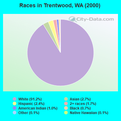
Races in Trentwood detailed stats: ancestries, foreign born residents, place of birth
 Recent articles from our blog. Our writers, many of them Ph.D. graduates or candidates, create easy-to-read articles on a wide variety of topics.


Latest news from Trentwood, WA collected exclusively by city-data.com from local newspapers, TV, and radio stations
Ancestries: German (27.7%), Irish (15.1%), English (11.4%), Norwegian (7.0%), Italian (4.5%), United States (4.4%).
Current Local Time: PST time zone
Elevation: 2025 feet
Land area: 1.77 square miles.
Population density: 2,703 people per square mile (average).
198 residents are foreign born (2.6% Asia, 1.0% Europe, 0.7% North America).
| This place: | 4.5% |
| Washington: | 10.4% |
| Trentwood CDP: | 1.5% ($1,670) |
| Washington: | 1.2% ($1,915) |
Nearest city with pop. 50,000+: Spokane Valley, WA (2.2 miles  , pop. 89,755).
Nearest city with pop. 200,000+: East Seattle, WA (230.9 miles , pop. 480,100).
Nearest city with pop. 1,000,000+: Los Angeles, CA (943.5 miles , pop. 3,694,820).
Nearest cities:
), ), ), ), ), ), )Latitude: 47.70 N, Longitude: 117.21 W
Area code commonly used in this area: 509
Property values in Trentwood, WA
| Here: | 5.0% |
| Washington: | 4.6% |
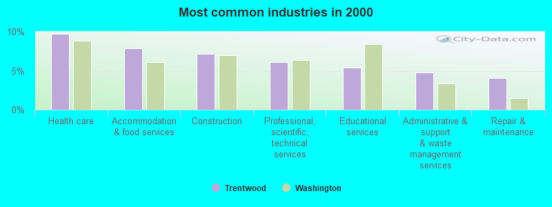
- Health care (9.7%)
- Accommodation & food services (7.9%)
- Construction (7.1%)
- Professional, scientific, technical services (6.1%)
- Educational services (5.4%)
- Administrative & support & waste management services (4.8%)
- Repair & maintenance (4.1%)
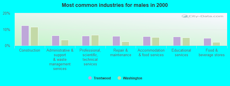
- Construction (12.4%)
- Administrative & support & waste management services (6.2%)
- Professional, scientific, technical services (5.9%)
- Repair & maintenance (5.8%)
- Accommodation & food services (5.6%)
- Educational services (5.5%)
- Food & beverage stores (4.5%)
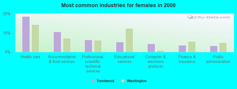
- Health care (18.6%)
- Accommodation & food services (10.5%)
- Professional, scientific, technical services (6.3%)
- Educational services (5.3%)
- Computer & electronic products (4.3%)
- Finance & insurance (3.5%)
- Public administration (3.2%)
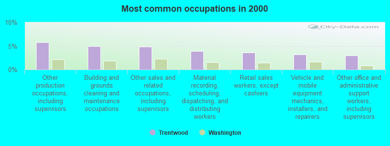
- Other production occupations, including supervisors (5.7%)
- Building and grounds cleaning and maintenance occupations (4.9%)
- Other sales and related occupations, including supervisors (4.8%)
- Material recording, scheduling, dispatching, and distributing workers (3.9%)
- Retail sales workers, except cashiers (3.7%)
- Vehicle and mobile equipment mechanics, installers, and repairers (3.2%)
- Other office and administrative support workers, including supervisors (3.0%)

- Other production occupations, including supervisors (8.1%)
- Other sales and related occupations, including supervisors (5.9%)
- Building and grounds cleaning and maintenance occupations (5.8%)
- Vehicle and mobile equipment mechanics, installers, and repairers (5.5%)
- Material recording, scheduling, dispatching, and distributing workers (5.4%)
- Laborers and material movers, hand (5.0%)
- Construction traders workers except carpenters, electricians, painters, plumbers, and construction laborers (4.5%)
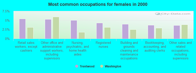
- Retail sales workers, except cashiers (5.4%)
- Other office and administrative support workers, including supervisors (5.3%)
- Nursing, psychiatric, and home health aides (5.1%)
- Registered nurses (4.3%)
- Building and grounds cleaning and maintenance occupations (4.0%)
- Bookkeeping, accounting, and auditing clerks (3.7%)
- Other sales and related occupations, including supervisors (3.6%)
Average climate in Trentwood, Washington
Based on data reported by over 4,000 weather stations


|
|

(lower is better)
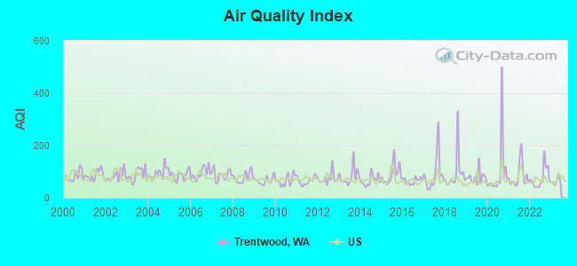
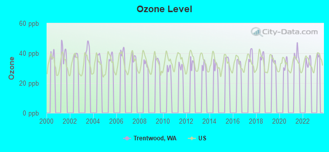
Air Quality Index (AQI) level in 2022 was 75.4. This is about average.
| City: | 75.4 |
| U.S.: | 72.6 |
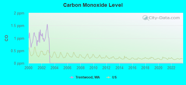
Carbon Monoxide (CO) [ppm] level in 2002 was 1.13. This is significantly worse than average. Closest monitor was 7.4 miles away from the city center.
| City: | 1.13 |
| U.S.: | 0.25 |
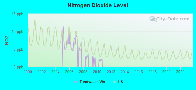
Nitrogen Dioxide (NO2) [ppb] level in 2007 was 6.56. This is worse than average. Closest monitor was 10.3 miles away from the city center.
| City: | 6.56 |
| U.S.: | 5.11 |
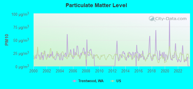
Particulate Matter (PM10) [µg/m3] level in 2022 was 16.3. This is about average. Closest monitor was 3.3 miles away from the city center.
| City: | 16.3 |
| U.S.: | 19.2 |
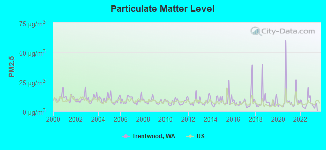
Particulate Matter (PM2.5) [µg/m3] level in 2022 was 7.84. This is about average. Closest monitor was 3.3 miles away from the city center.
| City: | 7.84 |
| U.S.: | 8.11 |
Earthquake activity:
Trentwood-area historical earthquake activity is significantly above Washington state average. It is 956% greater than the overall U.S. average.On 10/28/1983 at 14:06:06, a magnitude 7.3 (6.2 MB, 7.3 MS, 7.0 MW, Class: Major, Intensity: VIII - XII) earthquake occurred 299.5 miles away from the city center, causing 2 deaths (2 shaking deaths) and 3 injuries, causing $15,000,000 total damage
On 8/18/1959 at 06:37:13, a magnitude 7.7 (7.7 UK) earthquake occurred 381.5 miles away from the city center, causing $26,000,000 total damage
On 4/13/1949 at 19:55:42, a magnitude 7.0 (7.0 UK) earthquake occurred 249.2 miles away from Trentwood center, causing $80,000,000 total damage
On 2/28/2001 at 18:54:32, a magnitude 6.8 (6.5 MB, 6.6 MS, 6.8 MW, Class: Strong, Intensity: VII - IX) earthquake occurred 254.9 miles away from Trentwood center, causing $2,000,000,000 total damage and $305,000,000 insured losses
On 2/28/2001 at 18:54:32, a magnitude 6.8 (6.8 MD, Depth: 32.2 mi) earthquake occurred 260.9 miles away from Trentwood center
On 4/29/1965 at 15:28:43, a magnitude 6.6 (6.6 UK) earthquake occurred 240.7 miles away from the city center, causing $28,000,000 total damage
Magnitude types: body-wave magnitude (MB), duration magnitude (MD), surface-wave magnitude (MS), moment magnitude (MW)
Natural disasters:
The number of natural disasters in Spokane County (17) is near the US average (15).Major Disasters (Presidential) Declared: 11
Emergencies Declared: 4
Causes of natural disasters: Floods: 8, Storms: 5, Fires: 3, Landslides: 3, Mudslides: 3, Winter Storms: 3, Snows: 2, Drought: 1, Heavy Rain: 1, Hurricane: 1, Volcanic Eruption: 1, Wind: 1, Other: 1 (Note: some incidents may be assigned to more than one category).

Hospitals and medical centers near Trentwood:
- MISSION GOOD SAMARITAN (Nursing Home, about 3 miles away; SPOKANE, WA)
- VALLEY HOSPITAL Acute Care Hospitals (about 3 miles away; SPOKANE, WA)
- FMC VALLEY DIALYSIS UNIT (Dialysis Facility, about 3 miles away; SPOKANE, WA)
- FAMILY HOME CARE AND HOSPICE (Home Health Center, about 4 miles away; SPOKANE, WA)
- GENTIVA HEALTH SVS /SPOKANE (Home Health Center, about 4 miles away; SPOKANE, WA)
- MANSION HOUSE CONVALESCENT CENTER (Nursing Home, about 8 miles away; SPOKANE, WA)
- ALDERWOOD MANOR (Nursing Home, about 8 miles away; SPOKANE, WA)
Amtrak station near Trentwood:
Colleges/universities with over 2000 students nearest to Trentwood:
- Spokane Community College (about 8 miles; Spokane, WA; Full-time enrollment: 6,482)
- Gonzaga University (about 10 miles; Spokane, WA; FT enrollment: 6,780)
- Whitworth University (about 11 miles; Spokane, WA; FT enrollment: 2,689)
- Spokane Falls Community College (about 12 miles; Spokane, WA; FT enrollment: 6,052)
- North Idaho College (about 20 miles; Coeur d'Alene, ID; FT enrollment: 4,684)
- Eastern Washington University (about 23 miles; Cheney, WA; FT enrollment: 11,643)
- Washington State University (about 68 miles; Pullman, WA; FT enrollment: 25,055)
Points of interest:
Park in Trentwood: Antoine Plante Ferry Site Park (1). Display/hide its location on the map
| This place: | 2.8 people |
| Washington: | 2.5 people |
| This place: | 76.3% |
| Whole state: | 66.5% |
| This place: | 6.1% |
| Whole state: | 6.1% |
Likely homosexual households (counted as self-reported same-sex unmarried-partner households)
- Lesbian couples: 0.0% of all households
- Gay men: 0.1% of all households
| This place: | 8.6% |
| Whole state: | 10.6% |
| This place: | 4.5% |
| Whole state: | 4.6% |
For population 15 years and over in Trentwood:
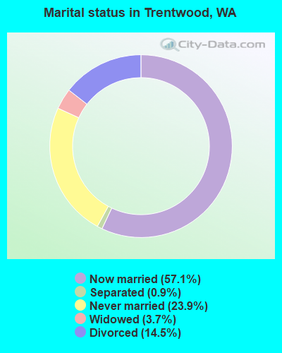
- Never married: 23.9%
- Now married: 57.1%
- Separated: 0.9%
- Widowed: 3.7%
- Divorced: 14.5%
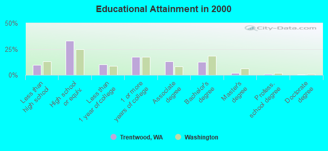
For population 25 years and over in Trentwood:
- High school or higher: 90.1%
- Bachelor's degree or higher: 15.7%
- Graduate or professional degree: 3.3%
- Unemployed: 5.7%
- Mean travel time to work (commute): 22.8 minutes
| Here: | 8.7 |
| Washington average: | 11.3 |
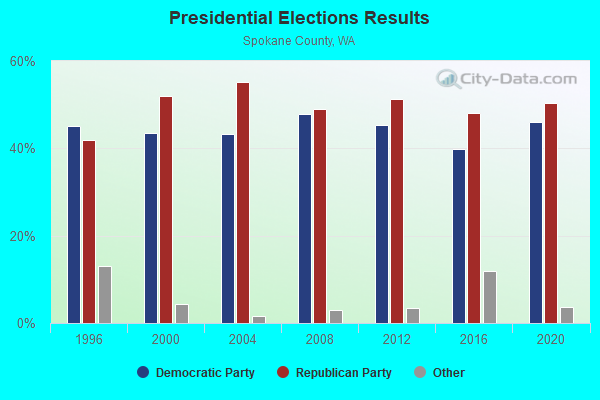
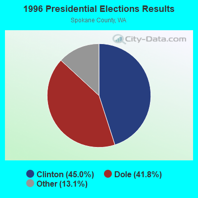
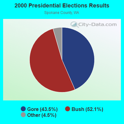
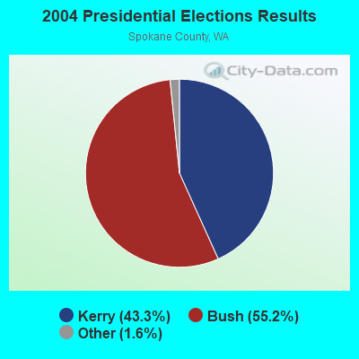
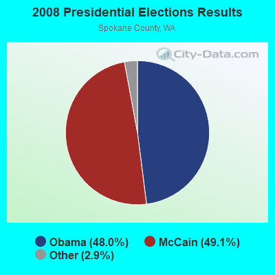
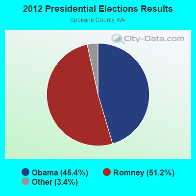
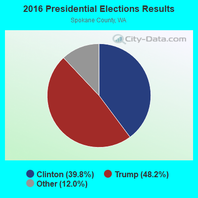
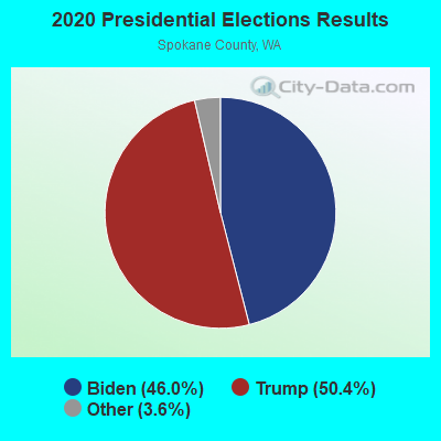
Graphs represent county-level data. Detailed 2008 Election Results
Religion statistics for Trentwood, WA (based on Spokane County data)
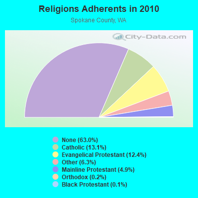
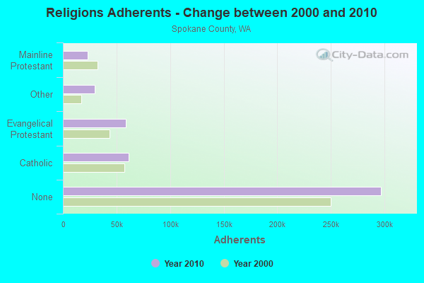
| Religion | Adherents | Congregations |
|---|---|---|
| Catholic | 61,575 | 27 |
| Evangelical Protestant | 58,417 | 217 |
| Other | 29,621 | 84 |
| Mainline Protestant | 23,240 | 81 |
| Orthodox | 754 | 3 |
| Black Protestant | 682 | 4 |
| None | 296,932 | - |
Food Environment Statistics:
| This county: | 1.80 / 10,000 pop. |
| State: | 2.06 / 10,000 pop. |
| This county: | 0.18 / 10,000 pop. |
| State: | 0.19 / 10,000 pop. |
| Here: | 0.61 / 10,000 pop. |
| Washington: | 1.18 / 10,000 pop. |
| Spokane County: | 2.59 / 10,000 pop. |
| State: | 2.67 / 10,000 pop. |
| Here: | 6.16 / 10,000 pop. |
| Washington: | 8.26 / 10,000 pop. |
| This county: | 8.2% |
| Washington: | 7.7% |
| This county: | 27.2% |
| State: | 25.7% |
| Here: | 9.7% |
| Washington: | 13.9% |
6.26% of this county's 2021 resident taxpayers lived in other counties in 2020 ($66,178 average adjusted gross income)
| Here: | 6.26% |
| Washington average: | 7.53% |
0.07% of residents moved from foreign countries ($698 average AGI)
Spokane County: 0.07% Washington average: 0.05%
Top counties from which taxpayers relocated into this county between 2020 and 2021:
| from Kootenai County, ID | |
| from King County, WA | |
| from Snohomish County, WA |
5.60% of this county's 2020 resident taxpayers moved to other counties in 2021 ($58,474 average adjusted gross income)
| Here: | 5.60% |
| Washington average: | 7.40% |
0.04% of residents moved to foreign countries ($518 average AGI)
Spokane County: 0.04% Washington average: 0.04%
Top counties to which taxpayers relocated from this county between 2020 and 2021:
| to Kootenai County, ID | |
| to King County, WA | |
| to Stevens County, WA |
Strongest AM radio stations in Trentwood:
- KXLY (920 AM; 20 kW; SPOKANE, WA; Owner: SPOKANE RADIO, INC.)
- KQNT (590 AM; 5 kW; SPOKANE, WA; Owner: CAPSTAR TX LIMITED PARTNERSHIP)
- KMJY (700 AM; 10 kW; NEWPORT, WA; Owner: JAMES E. AND HELEN G. STARGEL)
- KGA (1510 AM; 50 kW; SPOKANE, WA; Owner: CITADEL BROADCASTING COMPANY)
- KTRW (970 AM; 5 kW; SPOKANE, WA; Owner: KTRW, LLC)
- KJRB (790 AM; 5 kW; SPOKANE, WA; Owner: CITADEL BROADCASTING COMPANY)
- KDRK (1050 AM; 5 kW; DISHMAN, WA; Owner: CITADEL BROADCASTING COMPANY)
- KAQQ (1280 AM; 5 kW; SPOKANE, WA)
- KMBI (1330 AM; daytime; 5 kW; SPOKANE, WA; Owner: THE MOODY BIBLE INSTITUTE OF CHICAGO)
- KVNI (1080 AM; 10 kW; COEUR D' ALENE, ID; Owner: QUEENB RADIO, INC.)
- KXLI (630 AM; 1 kW; OPPORTUNITY, WA; Owner: QUEENB RADIO, INC.)
- KSBN (1230 AM; 1 kW; SPOKANE, WA; Owner: KSBN RADIO, INC.)
- KTBI (810 AM; daytime; 50 kW; EPHRATA, WA; Owner: TACOMA BROADCASTERS, INCORPORATED)
Strongest FM radio stations in Trentwood:
- KZZU-FM (92.9 FM; SPOKANE, WA; Owner: QUEENB)
- KEZE (96.9 FM; SPOKANE, WA; Owner: QUEENB RADIO, INC.)
- KEYF-FM (101.1 FM; CHENEY, WA; Owner: CITADEL BROADCASTING COMPANY)
- KISC (98.1 FM; SPOKANE, WA; Owner: CAPSTAR TX LIMITED PARTNERSHIP)
- KDRK-FM (93.7 FM; SPOKANE, WA; Owner: CITADEL BROADCASTING COMPANY)
- KIXZ-FM (96.1 FM; OPPORTUNITY, WA; Owner: CAPSTAR TX LIMITED PARTNERSHIP)
- KMBI-FM (107.9 FM; SPOKANE, WA; Owner: THE MOODY BIBLE INSTITUTE OF CHICAGO)
- KPBX-FM (91.1 FM; SPOKANE, WA; Owner: SPOKANE PUBLIC RADIO, INC.)
- KZBD (105.7 FM; SPOKANE, WA; Owner: CITADEL BROADCASTING COMPANY)
- KKZX (98.9 FM; SPOKANE, WA; Owner: CAPSTAR TX LIMITED PARTNERSHIP)
- KYWL (103.9 FM; SPOKANE, WA; Owner: CITADEL BROADCASTING COMPANY)
- KCDA (103.1 FM; POST FALLS, ID; Owner: CAPSTAR TX LIMITED PARTNERSHIP)
- KSFC (91.9 FM; SPOKANE, WA; Owner: SPOKANE PUBLIC RADIO)
- KAGU (88.7 FM; SPOKANE, WA; Owner: GONZAGA UNIVERSITY TELECOMMUNICATIONS ASSOCIATION)
- KEEH (104.9 FM; SPOKANE, WA; Owner: UPPER COLUMBIA MEDIA ASSOCIATION)
- KXLY-FM (99.9 FM; SPOKANE, WA; Owner: SPOKANE RADIO, INC.)
- KEWU-FM (89.5 FM; CHENEY, WA; Owner: EASTERN WASHINGTON UNIVERSITY)
- KICR (102.3 FM; COEUR D'ALENE, ID; Owner: GREAT NORTHERN BROADCASTING, INC.)
- KSPO (106.5 FM; DISHMAN, WA; Owner: THOMAS W. READ DBA CLASSICAL BROADCASTING)
- K262AG (100.3 FM; SPOKANE, ETC., WA; Owner: SPOKANE RADIO, INC.)
TV broadcast stations around Trentwood:
- KREM-TV (Channel 2; SPOKANE, WA; Owner: KING BROADCASTING COMPANY)
- KHQ-TV (Channel 6; SPOKANE, WA; Owner: KHQ, INCORPORATED)
- KSKN (Channel 22; SPOKANE, WA; Owner: KSKN TELEVISION, INC.)
- KAYU-TV (Channel 28; SPOKANE, WA; Owner: MOUNTAIN LICENSES, L.P.)
- KSPS-TV (Channel 7; SPOKANE, WA; Owner: SPOKANE SCHOOL DISTRICT #81)
- KGPX (Channel 34; SPOKANE, WA; Owner: PAXSON SPOKANE LICENSE, INC.)
- K09FZ (Channel 9; SPOKANE, ETC., WA; Owner: SPOKANE TELEVISION, INC.)
- K59BW (Channel 59; BONNERS FERRY, ID; Owner: STATE BOARD OF EDUCATION (IEPBS))
- K14IF (Channel 14; SPOKANE, WA; Owner: VENTANA TELEVISION, INC.)
- KHBA-LP (Channel 52; SPOKANE, WA; Owner: HE'S ALIVE BROADCASTING ASSOCIATION)
- K53FF (Channel 53; COEUR D'ALENE, ID; Owner: TRINITY BROADCASTING NETWORK)
- K55EB (Channel 55; SPOKANE, WA; Owner: TRINITY BROADCASTING NETWORK)
- KXLY-TV (Channel 4; SPOKANE, WA; Owner: SPOKANE TELEVISION, INC.)
- KQUP-LP (Channel 47; COEUR D'ALENE, ID; Owner: PULLMAN BROADCASTING, INC.)
- KTYJ-LP (Channel 58; COEUR D'ALENE, ID; Owner: CHRISTIAN BROADCASTING OF IDAHO, INC.)
- National Bridge Inventory (NBI) Statistics
- 2Number of bridges
- 23ft / 7.2mTotal length
- $7,752,000Total costs
- 49,400Total average daily traffic
- 6,422Total average daily truck traffic
- 60,200Total future (year 2038) average daily traffic
FCC Registered Microwave Towers:
1- Next To 15000 E Euclid (Lat: 47.684472 Lon: -117.209972), Structure height: 7.6 m, Call Sign: WPNJ231,
Assigned Frequencies: 957.350 MHz, Grant Date: 12/05/2012, Expiration Date: 01/26/2023, Cancellation Date: 04/01/2023, Registrant: Gillespie, Prudhon & Associates, 16111 Se 106th Avenue, Suite 100, Clackamas, OR 97015, Phone: (503) 657-0424, Fax: (503) 657-0361, Email:
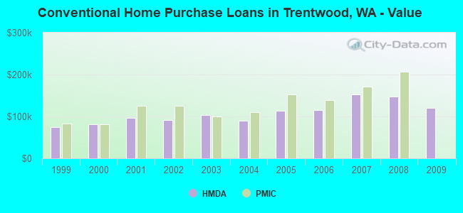
| Home Mortgage Disclosure Act Aggregated Statistics For Year 2009 (Based on 1 partial tract) | ||||||||||||
| A) FHA, FSA/RHS & VA Home Purchase Loans | B) Conventional Home Purchase Loans | C) Refinancings | D) Home Improvement Loans | F) Non-occupant Loans on < 5 Family Dwellings (A B C & D) | G) Loans On Manufactured Home Dwelling (A B C & D) | |||||||
|---|---|---|---|---|---|---|---|---|---|---|---|---|
| Number | Average Value | Number | Average Value | Number | Average Value | Number | Average Value | Number | Average Value | Number | Average Value | |
| LOANS ORIGINATED | 7 | $155,456 | 4 | $119,508 | 36 | $147,633 | 2 | $74,150 | 2 | $130,585 | 2 | $92,835 |
| APPLICATIONS APPROVED, NOT ACCEPTED | 0 | $0 | 0 | $0 | 3 | $154,723 | 0 | $0 | 1 | $91,490 | 0 | $0 |
| APPLICATIONS DENIED | 1 | $86,280 | 0 | $0 | 9 | $158,531 | 2 | $80,505 | 0 | $0 | 0 | $0 |
| APPLICATIONS WITHDRAWN | 6 | $144,835 | 2 | $161,975 | 9 | $155,064 | 0 | $0 | 1 | $80,510 | 1 | $47,570 |
| FILES CLOSED FOR INCOMPLETENESS | 0 | $0 | 0 | $0 | 2 | $109,010 | 0 | $0 | 0 | $0 | 0 | $0 |
Detailed HMDA statistics for the following Tracts: 0114.00
| Private Mortgage Insurance Companies Aggregated Statistics For Year 2009 (Based on 1 partial tract) | ||
| B) Refinancings | ||
|---|---|---|
| Number | Average Value | |
| LOANS ORIGINATED | 1 | $175,840 |
| APPLICATIONS APPROVED, NOT ACCEPTED | 0 | $0 |
| APPLICATIONS DENIED | 0 | $0 |
| APPLICATIONS WITHDRAWN | 0 | $0 |
| FILES CLOSED FOR INCOMPLETENESS | 0 | $0 |
Detailed PMIC statistics for the following Tracts: 0114.00
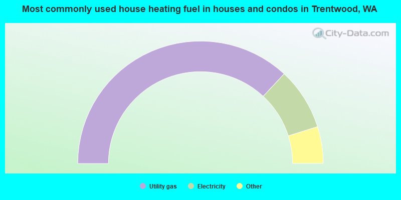
- 73.8%Utility gas
- 16.4%Electricity
- 3.9%Wood
- 3.6%Fuel oil, kerosene, etc.
- 1.7%Bottled, tank, or LP gas
- 0.6%No fuel used
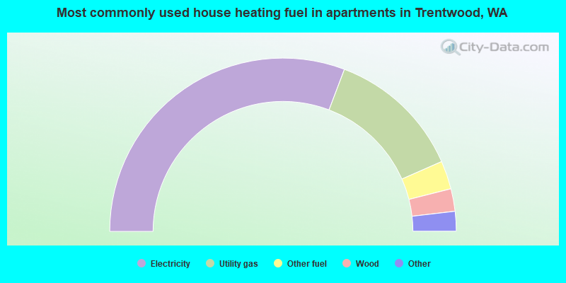
- 61.6%Electricity
- 25.3%Utility gas
- 5.3%Other fuel
- 4.2%Wood
- 1.8%Bottled, tank, or LP gas
- 1.8%Fuel oil, kerosene, etc.
Trentwood compared to Washington state average:
- Unemployed percentage below state average.
- Black race population percentage significantly below state average.
- Hispanic race population percentage significantly below state average.
- Foreign-born population percentage significantly below state average.
- Renting percentage significantly below state average.
- Length of stay since moving in significantly above state average.
- Number of rooms per house significantly below state average.
- House age significantly below state average.
- Percentage of population with a bachelor's degree or higher below state average.