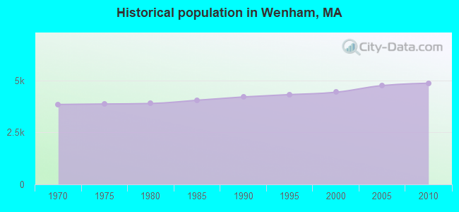
Wenham, Massachusetts
Submit your own pictures of this town and show them to the world
- OSM Map
- General Map
- Google Map
- MSN Map
Population change since 2000: +9.8%
 |
| Males: 2,206 | |
| Females: 2,669 |
| Median resident age: | 26.8 years |
| Massachusetts median age: | 39.2 years |
Zip codes: 01984.
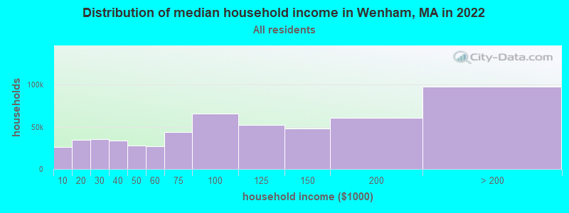
| Wenham: | $162,199 |
| MA: | $94,488 |
Estimated per capita income in 2022: $71,571 (it was $36,812 in 2000)
Wenham town income, earnings, and wages data
Estimated median house or condo value in 2022: over $1,000,000 (it was $357,100 in 2000)
| Wenham: | over $1,000,000 |
| MA: | $534,700 |
Mean prices in 2022: all housing units: $645,471; detached houses: $712,185; townhouses or other attached units: $551,275; in 2-unit structures: $503,219; in 3-to-4-unit structures: $450,535; in 5-or-more-unit structures: $352,534; mobile homes: $123,118; occupied boats, rvs, vans, etc.: $131,058
Detailed information about poverty and poor residents in Wenham, MA


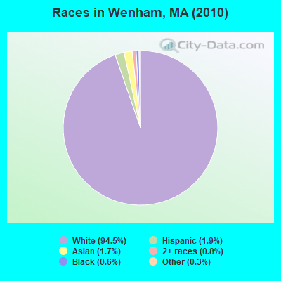
- 4,60794.5%White alone
- 951.9%Hispanic
- 821.7%Asian alone
- 380.8%Two or more races
- 290.6%Black alone
- 160.3%Other race alone
- 40.08%American Indian alone
- 40.08%Native Hawaiian and Other
Pacific Islander alone
Races in Wenham detailed stats: ancestries, foreign born residents, place of birth
According to our research of Massachusetts and other state lists, there were 2 registered sex offenders living in Wenham, Massachusetts as of May 07, 2024.
The ratio of all residents to sex offenders in Wenham is 2,438 to 1.
The ratio of registered sex offenders to all residents in this city is lower than the state average.
Type |
2009 |
2010 |
2011 |
2012 |
2013 |
2014 |
2015 |
2016 |
2017 |
2018 |
2019 |
2020 |
2021 |
2022 |
|---|---|---|---|---|---|---|---|---|---|---|---|---|---|---|
| Murders (per 100,000) | 0 (0.0) | 0 (0.0) | 0 (0.0) | 0 (0.0) | 0 (0.0) | 0 (0.0) | 0 (0.0) | 0 (0.0) | 0 (0.0) | 0 (0.0) | 0 (0.0) | 0 (0.0) | 0 (0.0) | 0 (0.0) |
| Rapes (per 100,000) | 1 (21.4) | 0 (0.0) | 0 (0.0) | 0 (0.0) | 3 (59.5) | 2 (39.1) | 0 (0.0) | 1 (19.2) | 0 (0.0) | 0 (0.0) | 0 (0.0) | 1 (18.9) | 0 (0.0) | 0 (0.0) |
| Robberies (per 100,000) | 1 (21.4) | 0 (0.0) | 0 (0.0) | 0 (0.0) | 0 (0.0) | 1 (19.6) | 0 (0.0) | 0 (0.0) | 1 (19.1) | 0 (0.0) | 0 (0.0) | 0 (0.0) | 0 (0.0) | 0 (0.0) |
| Assaults (per 100,000) | 1 (21.4) | 4 (82.1) | 2 (40.8) | 3 (60.6) | 6 (118.9) | 1 (19.6) | 3 (57.3) | 5 (96.2) | 1 (19.1) | 3 (56.6) | 0 (0.0) | 2 (37.8) | 0 (0.0) | 7 (140.1) |
| Burglaries (per 100,000) | 6 (128.6) | 3 (61.5) | 7 (142.7) | 4 (80.8) | 2 (39.6) | 2 (39.1) | 3 (57.3) | 1 (19.2) | 0 (0.0) | 2 (37.7) | 1 (18.9) | 0 (0.0) | 1 (19.1) | 1 (20.0) |
| Thefts (per 100,000) | 14 (300.1) | 27 (553.8) | 24 (489.3) | 27 (545.7) | 24 (475.7) | 8 (156.4) | 6 (114.5) | 10 (192.4) | 8 (152.6) | 12 (226.5) | 6 (113.3) | 19 (358.8) | 12 (229.2) | 10 (200.1) |
| Auto thefts (per 100,000) | 0 (0.0) | 3 (61.5) | 0 (0.0) | 2 (40.4) | 3 (59.5) | 0 (0.0) | 0 (0.0) | 0 (0.0) | 0 (0.0) | 0 (0.0) | 1 (18.9) | 0 (0.0) | 0 (0.0) | 1 (20.0) |
| Arson (per 100,000) | 1 (21.4) | 0 (0.0) | 0 (0.0) | 0 (0.0) | 0 (0.0) | 0 (0.0) | 0 (0.0) | 0 (0.0) | 0 (0.0) | 0 (0.0) | 0 (0.0) | 0 (0.0) | 0 (0.0) | 0 (0.0) |
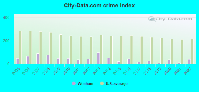
| City-Data.com crime index | 48.9 | 47.8 | 37.7 | 42.8 | 97.9 | 50.1 | 20.0 | 43.7 | 15.6 | 23.0 | 7.4 | 37.0 | 10.5 | 39.0 |
The City-Data.com crime index weighs serious crimes and violent crimes more heavily. Higher means more crime, U.S. average is 246.1. It adjusts for the number of visitors and daily workers commuting into cities.
Crime rate in Wenham detailed stats: murders, rapes, robberies, assaults, burglaries, thefts, arson
Full-time law enforcement employees in 2021, including police officers: 11 (10 officers - 9 male; 1 female).
| Officers per 1,000 residents here: | 1.91 |
| Massachusetts average: | 2.53 |
 Recent articles from our blog. Our writers, many of them Ph.D. graduates or candidates, create easy-to-read articles on a wide variety of topics.

 | Towns within 495 with nice walkable downtowns and good schools (205 replies) |
| Tell Me all About Hamilton-Wenham (4 replies) |
| Andover vs. Wenham (19 replies) |
| Which are the most happening Towns in Mass? (42 replies) |
| Spring Hill Development Wenham (6 replies) |
| North Shore mass - family town to move to (15 replies) |
Latest news from Wenham, MA collected exclusively by city-data.com from local newspapers, TV, and radio stations
Wenham, MA City Guides:
Ancestries: Irish (23.6%), English (22.5%), German (10.9%), Italian (8.8%), United States (5.7%), French (5.2%).
Current Local Time: EST time zone
Incorporated in 1643
Land area: 7.72 square miles.
Population density: 632 people per square mile (low).
177 residents are foreign born (2.3% Europe, 1.4% North America).
| This town: | 4.0% |
| Massachusetts: | 12.2% |
| Wenham town: | 1.2% ($4,148) |
| Massachusetts: | 1.3% ($2,336) |
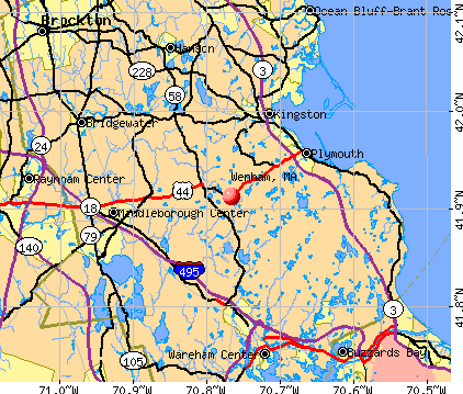
Nearest city with pop. 50,000+: Lynn, MA  (9.6 miles , pop. 89,050).
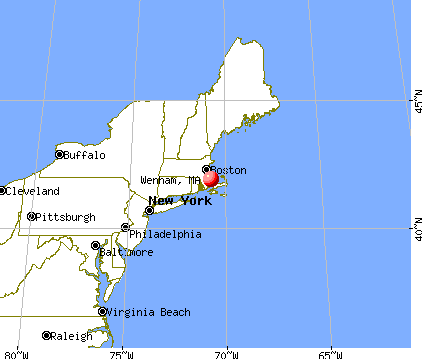
Nearest city with pop. 200,000+: Boston, MA (22.1 miles , pop. 589,141).
Nearest city with pop. 1,000,000+: Bronx, NY (196.6 miles , pop. 1,332,650).
Nearest cities:
), Latitude: 42.60 N, Longitude: 70.88 W
Area code commonly used in this area: 978

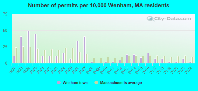
Single-family new house construction building permits:
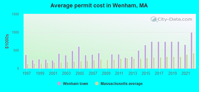
- 2022: 1 building, cost: $1,000,000
- 2021: 3 buildings, average cost: $664,300
- 2020: 1 building, cost: $746,400
- 2019: 1 building, cost: $746,400
- 2018: 3 buildings, average cost: $746,400
- 2017: 3 buildings, average cost: $746,400
- 2016: 7 buildings, average cost: $746,400
- 2015: 4 buildings, average cost: $650,000
- 2014: 6 buildings, average cost: $500,000
- 2013: 6 buildings, average cost: $328,700
- 2012: 2 buildings, average cost: $302,500
- 2011: 1 building, cost: $400,000
- 2010: 1 building, cost: $400,000
- 2008: 1 building, cost: $433,000
- 2007: 18 buildings, average cost: $388,500
- 2006: 15 buildings, average cost: $376,500
- 2005: 3 buildings, average cost: $606,700
- 2004: 7 buildings, average cost: $493,400
- 2003: 5 buildings, average cost: $376,600
- 2002: 5 buildings, average cost: $417,200
- 2001: 5 buildings, average cost: $231,400
- 2000: 20 buildings, average cost: $251,600
- 1999: 22 buildings, average cost: $260,100
- 1998: 18 buildings, average cost: $234,900
- 1997: 5 buildings, average cost: $384,900
| Here: | 3.3% |
| Massachusetts: | 3.5% |
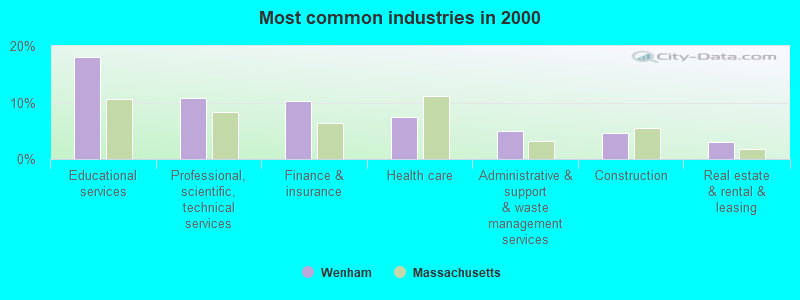
- Educational services (18.1%)
- Professional, scientific, technical services (10.8%)
- Finance & insurance (10.2%)
- Health care (7.4%)
- Administrative & support & waste management services (4.9%)
- Construction (4.7%)
- Real estate & rental & leasing (3.1%)
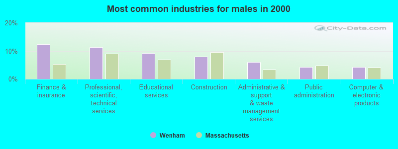
- Finance & insurance (12.5%)
- Professional, scientific, technical services (11.3%)
- Educational services (9.3%)
- Construction (7.9%)
- Administrative & support & waste management services (5.9%)
- Public administration (4.2%)
- Computer & electronic products (4.2%)
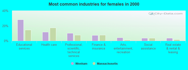
- Educational services (28.3%)
- Health care (11.8%)
- Professional, scientific, technical services (10.2%)
- Finance & insurance (7.5%)
- Arts, entertainment, recreation (4.4%)
- Social assistance (3.8%)
- Real estate & rental & leasing (3.7%)
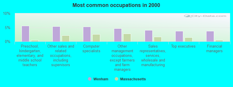
- Preschool, kindergarten, elementary, and middle school teachers (5.5%)
- Other sales and related occupations, including supervisors (5.4%)
- Computer specialists (5.3%)
- Other management occupations, except farmers and farm managers (4.7%)
- Sales representatives, services, wholesale and manufacturing (4.0%)
- Top executives (3.7%)
- Financial managers (3.7%)
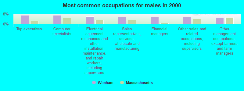
- Top executives (7.0%)
- Computer specialists (7.0%)
- Electrical equipment mechanics and other installation, maintenance, and repair workers, including supervisors (6.2%)
- Sales representatives, services, wholesale and manufacturing (5.7%)
- Financial managers (5.6%)
- Other sales and related occupations, including supervisors (5.5%)
- Other management occupations, except farmers and farm managers (5.4%)
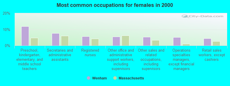
- Preschool, kindergarten, elementary, and middle school teachers (11.9%)
- Secretaries and administrative assistants (7.5%)
- Registered nurses (5.7%)
- Other office and administrative support workers, including supervisors (5.6%)
- Other sales and related occupations, including supervisors (5.3%)
- Operations specialties managers, except financial managers (5.2%)
- Retail sales workers, except cashiers (4.4%)
Average climate in Wenham, Massachusetts
Based on data reported by over 4,000 weather stations


(lower is better)
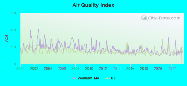
Air Quality Index (AQI) level in 2022 was 74.3. This is about average.
| City: | 74.3 |
| U.S.: | 72.6 |
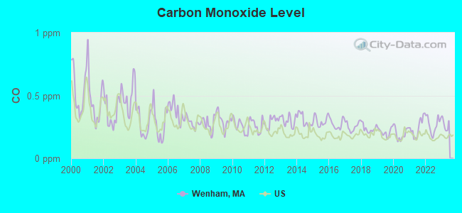
Carbon Monoxide (CO) [ppm] level in 2022 was 0.268. This is about average. Closest monitor was 17.1 miles away from the city center.
| City: | 0.268 |
| U.S.: | 0.251 |
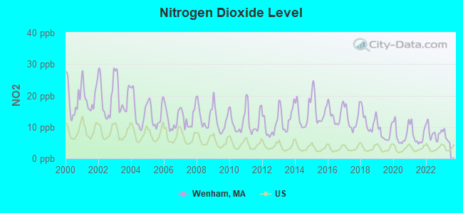
Nitrogen Dioxide (NO2) [ppb] level in 2022 was 8.12. This is significantly worse than average. Closest monitor was 6.4 miles away from the city center.
| City: | 8.12 |
| U.S.: | 5.11 |
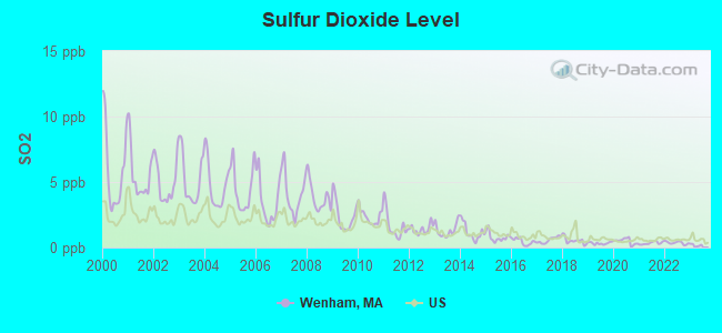
Sulfur Dioxide (SO2) [ppb] level in 2022 was 0.358. This is significantly better than average. Closest monitor was 2.9 miles away from the city center.
| City: | 0.358 |
| U.S.: | 1.515 |
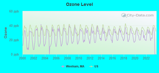
Ozone [ppb] level in 2022 was 27.3. This is better than average. Closest monitor was 5.1 miles away from the city center.
| City: | 27.3 |
| U.S.: | 33.3 |
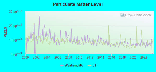
Particulate Matter (PM2.5) [µg/m3] level in 2022 was 6.51. This is better than average. Closest monitor was 10.0 miles away from the city center.
| City: | 6.51 |
| U.S.: | 8.11 |
Tornado activity:
Wenham-area historical tornado activity is slightly below Massachusetts state average. It is 50% smaller than the overall U.S. average.
On 9/29/1974, a category F3 (max. wind speeds 158-206 mph) tornado 16.5 miles away from the Wenham town center injured one person and caused between $50,000 and $500,000 in damages.
On 6/9/1953, a category F4 (max. wind speeds 207-260 mph) tornado 38.9 miles away from the town center killed 90 people and injured 1228 people and caused between $50,000,000 and $500,000,000 in damages.
Earthquake activity:
Wenham-area historical earthquake activity is significantly above Massachusetts state average. It is 74% smaller than the overall U.S. average.On 4/20/2002 at 10:50:47, a magnitude 5.3 (5.3 ML, Depth: 3.0 mi, Class: Moderate, Intensity: VI - VII) earthquake occurred 193.6 miles away from the city center
On 10/16/2012 at 23:12:25, a magnitude 4.7 (4.7 ML, Depth: 10.0 mi, Class: Light, Intensity: IV - V) earthquake occurred 69.8 miles away from Wenham center
On 1/19/1982 at 00:14:42, a magnitude 4.7 (4.5 MB, 4.7 MD, 4.5 LG) earthquake occurred 72.2 miles away from the city center
On 10/7/1983 at 10:18:46, a magnitude 5.3 (5.1 MB, 5.3 LG, 5.1 ML) earthquake occurred 198.0 miles away from Wenham center
On 4/20/2002 at 10:50:47, a magnitude 5.2 (5.2 MB, 4.2 MS, 5.2 MW, 5.0 MW) earthquake occurred 193.2 miles away from the city center
On 8/22/1992 at 12:20:32, a magnitude 4.8 (4.8 MB, 3.8 MS, 4.7 LG, Depth: 6.2 mi) earthquake occurred 243.5 miles away from the city center
Magnitude types: regional Lg-wave magnitude (LG), body-wave magnitude (MB), duration magnitude (MD), local magnitude (ML), surface-wave magnitude (MS), moment magnitude (MW)
Natural disasters:
The number of natural disasters in Essex County (33) is a lot greater than the US average (15).Major Disasters (Presidential) Declared: 20
Emergencies Declared: 13
Causes of natural disasters: Floods: 14, Storms: 11, Hurricanes: 6, Snowstorms: 5, Winter Storms: 5, Snows: 3, Blizzards: 2, Fire: 1, Heavy Rain: 1, Snowfall: 1, Water Main Break: 1, Wind: 1 (Note: some incidents may be assigned to more than one category).

Hospitals and medical centers near Wenham:
- NORTH SHORE REGIONAL DIALYSIS CENTER (Dialysis Facility, about 2 miles away; BEVERLY, MA)
- A B L VISITING NURSING CERTIFIED (Home Health Center, about 2 miles away; BEVERLY, MA)
- BLUEBERYHILL HEALTHCARE N H (Nursing Home, about 3 miles away; BEVERLY, MA)
- KINDRED TRANSITIONAL CARE AND REHAB-BLUEBERRY HILL (Nursing Home, about 3 miles away; BEVERLY, MA)
- LEDGEWOOD NURSING CENTER (Nursing Home, about 3 miles away; BEVERLY, MA)
- LEDGEWOOD REHABILITATION AND SKILLED NURSING CENTER (Nursing Home, about 3 miles away; BEVERLY, MA)
- BEVERLY HOSPITAL CORPORATION Acute Care Hospitals (about 3 miles away; BEVERLY, MA)
Operable nuclear power plant near Wenham:
- 20 miles: Seabrook in Seabrook, NH.
College/University in Wenham:
Colleges/universities with over 2000 students nearest to Wenham:
- Endicott College (about 4 miles; Beverly, MA; Full-time enrollment: 4,064)
- North Shore Community College (about 5 miles; Danvers, MA; FT enrollment: 5,195)
- Salem State University (about 7 miles; Salem, MA; FT enrollment: 8,027)
- Merrimack College (about 14 miles; North Andover, MA; FT enrollment: 2,734)
- Northern Essex Community College (about 17 miles; Haverhill, MA; FT enrollment: 4,737)
- Tufts University (about 19 miles; Medford, MA; FT enrollment: 9,041)
- Bunker Hill Community College (about 19 miles; Boston, MA; FT enrollment: 8,814)
Public elementary/middle school in Wenham:
- BESSIE BUKER ELEMENTARY (Students: 229, Location: 1 SCHOOL STREET, Grades: KG-5)
Private elementary/middle school in Wenham:
Points of interest:
Notable locations in Wenham: Iron Rail Girls Camp (A), Wenham Townhall (B), Wenham Fire Department (C), Jenks Learning Resource Center (D). Display/hide their locations on the map
Churches in Wenham include: Wenham Church (A), First Church in Wenhem (B). Display/hide their locations on the map
Cemetery: Wenham Cemetery (1). Display/hide its location on the map
Lakes and swamps: Cedar Pond (A), Muddy Pond (B), Coy Pond (C), Wenham Lake (D), Pleasant Pond (E), Wenham Swamp (F). Display/hide their locations on the map
Birthplace of: Joe Batchelder - Baseball player.
Drinking water stations with addresses in Wenham and their reported violations in the past:
WENHAM WATER DEPT. (Population served: 3,875, Groundwater):Past health violations:BLUEBERRY KNOLL ESTATES (Serves NH, Population served: 32, Groundwater):Past monitoring violations:
- MCL, Acute (TCR) - In OCT-2011, Contaminant: Coliform. Follow-up actions: St Boil Water Order (OCT-04-2011)
- MCL, Monthly (TCR) - In APR-2011, Contaminant: Coliform. Follow-up actions: St AO (w/penalty) issued (JAN-31-2012)
- MCL, Monthly (TCR) - In OCT-2010, Contaminant: Coliform. Follow-up actions: St AO (w/o penalty) issued (NOV-18-2010)
- MCL, Monthly (TCR) - In SEP-2010, Contaminant: Coliform. Follow-up actions: St AO (w/o penalty) issued (OCT-07-2010)
- MCL, Monthly (TCR) - In MAR-2009, Contaminant: Coliform. Follow-up actions: St AO (w/o penalty) issued (MAY-18-2009)
- MCL, Monthly (TCR) - In DEC-2008, Contaminant: Coliform. Follow-up actions: St AO (w/o penalty) issued (2 times from JAN-26-2009 to MAY-18-2009)
- MCL, Monthly (TCR) - In AUG-2008, Contaminant: Coliform. Follow-up actions: St AO (w/o penalty) issued (2 times from SEP-03-2008 to MAY-18-2009)
- Monitoring, Repeat Major (TCR) - In JAN-2009, Contaminant: Coliform (TCR). Follow-up actions: St AO (w/o penalty) issued (2 times from FEB-23-2009 to MAY-18-2009)
Past health violations:Past monitoring violations:
- MCL, Monthly (TCR) - In JUL-2006, Contaminant: Coliform. Follow-up actions: St Public Notif requested (AUG-11-2006), St Violation/Reminder Notice (AUG-11-2006), St Public Notif received (AUG-15-2006), St Compliance achieved (JAN-31-2007)
- One regular monitoring violation
| This town: | 2.7 people |
| Massachusetts: | 2.5 people |
| This town: | 73.2% |
| Whole state: | 63.0% |
| This town: | 2.9% |
| Whole state: | 7.0% |
Likely homosexual households (counted as self-reported same-sex unmarried-partner households)
- Lesbian couples: 0.4% of all households
- Gay men: 0.4% of all households
| This town: | 3.3% |
| Whole state: | 9.3% |
| This town: | 1.1% |
| Whole state: | 4.4% |
12 people in group homes intended for adults in 2010
People in group quarters in Wenham in 2000:
- 951 people in college dormitories (includes college quarters off campus)
- 8 people in homes for the mentally retarded
- 8 people in other group homes
- 4 people in homes for the physically handicapped
For population 15 years and over in Wenham:
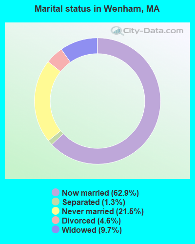
- Never married: 21.5%
- Now married: 62.9%
- Separated: 1.3%
- Widowed: 9.7%
- Divorced: 4.6%
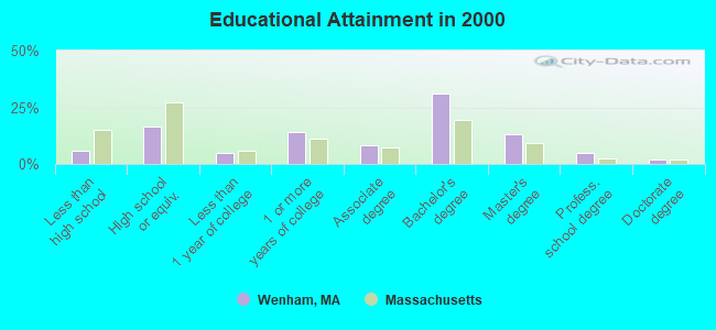
For population 25 years and over in Wenham:
- High school or higher: 94.3%
- Bachelor's degree or higher: 50.6%
- Graduate or professional degree: 19.7%
- Unemployed: 30.7%
- Mean travel time to work (commute): 29.2 minutes
| Here: | 9.9 |
| Massachusetts average: | 13.1 |


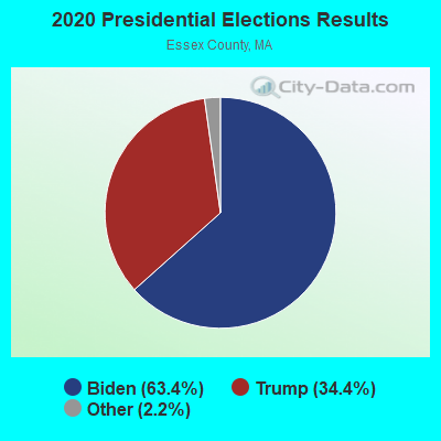
Graphs represent county-level data. Detailed 2008 Election Results
Religion statistics for Wenham, MA (based on Essex County data)


| Religion | Adherents | Congregations |
|---|---|---|
| Catholic | 341,970 | 55 |
| Mainline Protestant | 33,710 | 140 |
| Evangelical Protestant | 20,925 | 160 |
| Other | 15,882 | 63 |
| Orthodox | 11,590 | 13 |
| Black Protestant | 376 | 3 |
| None | 318,706 | - |
Food Environment Statistics:
| Essex County: | 1.98 / 10,000 pop. |
| Massachusetts: | 1.98 / 10,000 pop. |
| This county: | 0.04 / 10,000 pop. |
| State: | 0.05 / 10,000 pop. |
| Here: | 1.97 / 10,000 pop. |
| State: | 2.22 / 10,000 pop. |
| Essex County: | 1.30 / 10,000 pop. |
| Massachusetts: | 1.77 / 10,000 pop. |
| Here: | 7.60 / 10,000 pop. |
| State: | 8.76 / 10,000 pop. |
| Essex County: | 8.4% |
| State: | 8.1% |
| Essex County: | 23.7% |
| Massachusetts: | 22.5% |
| Here: | 20.7% |
| State: | 16.5% |
5.09% of this county's 2021 resident taxpayers lived in other counties in 2020 ($96,821 average adjusted gross income)
| Here: | 5.09% |
| Massachusetts average: | 6.35% |
0.01% of residents moved from foreign countries ($21 average AGI)
Essex County: 0.01% Massachusetts average: 0.01%
Top counties from which taxpayers relocated into this county between 2020 and 2021:
| from Middlesex County, MA | |
| from Suffolk County, MA | |
| from Rockingham County, NH |
5.47% of this county's 2020 resident taxpayers moved to other counties in 2021 ($95,440 average adjusted gross income)
| Here: | 5.47% |
| Massachusetts average: | 7.18% |
0.01% of residents moved to foreign countries ($53 average AGI)
Essex County: 0.01% Massachusetts average: 0.02%
Top counties to which taxpayers relocated from this county between 2020 and 2021:
| to Middlesex County, MA | |
| to Rockingham County, NH | |
| to Suffolk County, MA |
Strongest AM radio stations in Wenham:
- WRKO (680 AM; 50 kW; BOSTON, MA; Owner: ENTERCOM BOSTON LICENSE, LLC)
- WNSH (1570 AM; 5 kW; BEVERLY, MA)
- WBZ (1030 AM; 50 kW; BOSTON, MA; Owner: INFINITY BROADCASTING OPERATIONS, INC.)
- WWZN (1510 AM; 50 kW; BOSTON, MA; Owner: ROSE CITY RADIO CORPORATION)
- WEEI (850 AM; 50 kW; BOSTON, MA; Owner: ENTERCOM BOSTON LICENSE, LLC)
- WKOX (1200 AM; 50 kW; FRAMINGHAM, MA; Owner: CAPSTAR TX LIMITED PARTNERSHIP)
- WROL (950 AM; 5 kW; BOSTON, MA; Owner: SCA LICENSE CORPORATION)
- WBIX (1060 AM; 40 kW; NATICK, MA; Owner: LANGER BROADCASTING CORPORATION)
- WRCA (1330 AM; 25 kW; WALTHAM, MA; Owner: WRCA LICENSE, LLC)
- WEZE (590 AM; 5 kW; BOSTON, MA; Owner: NEW ENGLAND CONTINENTAL MEDIA, INC.)
- WESX (1230 AM; 1 kW; SALEM, MA; Owner: NORTH SHORE BROADCASTING CORP.)
- WAMG (890 AM; 25 kW; DEDHAM, MA; Owner: MEGA COMMUNICATIONS OF DEDHAM LICENSEE, LLC)
- WUNR (1600 AM; 20 kW; BROOKLINE, MA; Owner: CHAMPION BROADCASTING SYSTEMS, INC.)
Strongest FM radio stations in Wenham:
- WQSX (93.7 FM; LAWRENCE, MA; Owner: ENTERCOM BOSTON LICENSE, LLC)
- WBOQ (104.9 FM; GLOUCESTER, MA; Owner: MARLIN BROADCASTING, LLC)
- WXKS-FM (107.9 FM; MEDFORD, MA; Owner: AMFM RADIO LICENSES, L.L.C.)
- WMJX (106.7 FM; BOSTON, MA; Owner: GREATER BOSTON RADIO, INC.)
- WXRV (92.5 FM; HAVERHILL, MA; Owner: BEANPOT BROADCASTING CORP.)
- WBMX (98.5 FM; BOSTON, MA; Owner: INFINITY RADIO OPERATIONS INC.)
- WKLB-FM (99.5 FM; LOWELL, MA; Owner: GREATER BOSTON RADIO, INC.)
- WJMN (94.5 FM; BOSTON, MA; Owner: AMFM RADIO LICENSES, L.L.C.)
- WCRB (102.5 FM; WALTHAM, MA; Owner: CHARLES RIVER BROADCASTING WCRB LICE)
- WTKK (96.9 FM; BOSTON, MA; Owner: GREATER BOSTON RADIO, INC.)
- WBOS (92.9 FM; BROOKLINE, MA; Owner: GREATER BOSTON RADIO, INC.)
- WROR-FM (105.7 FM; FRAMINGHAM, MA; Owner: GREATER BOSTON RADIO, INC.)
- W267AI (101.3 FM; BOSTON, MA; Owner: MCC BROADCASTING COMPANY, INC.)
- WBCN (104.1 FM; BOSTON, MA; Owner: HEMISPHERE BROADCASTING CORPORATION)
- WZLX (100.7 FM; BOSTON, MA; Owner: INFINITY BROADCASTING CORPORATION OF BOSTON)
- WERS (88.9 FM; BOSTON, MA; Owner: EMERSON COLLEGE)
- WGBH (89.7 FM; BOSTON, MA; Owner: WGBH EDUCATIONAL FOUNDATION)
- WBUR-FM (90.9 FM; BOSTON, MA; Owner: TRUSTEES OF BOSTON UNIVERSITY)
- W227AM (93.3 FM; ANDOVER, MA; Owner: GREATER BOSTON RADIO, INC.)
- WHRB (95.3 FM; CAMBRIDGE, MA; Owner: HARVARD RADIO BROADCASTING CO., INC.)
TV broadcast stations around Wenham:
- WCVB-TV (Channel 5; BOSTON, MA; Owner: WCVB HEARST-ARGYLE TV, INC.)
- WGBH-TV (Channel 2; BOSTON, MA; Owner: WGBH EDUCATIONAL FOUNDATION)
- WFXZ-CA (Channel 24; BOSTON, MA; Owner: BOSTON BROADCASTING CORP.)
- WBPX (Channel 68; BOSTON, MA; Owner: PAXSON BOSTON-68 LICENSE, INC.)
- WHDH-TV (Channel 7; BOSTON, MA; Owner: WHDH-TV)
- WMFP (Channel 62; LAWRENCE, MA; Owner: WSAH LICENSE, INC.)
- WSBK-TV (Channel 38; BOSTON, MA; Owner: VIACOM INC.)
- WLVI-TV (Channel 56; CAMBRIDGE, MA; Owner: WLVI, INC.)
- WBZ-TV (Channel 4; BOSTON, MA; Owner: VIACOM INC.)
- WGBX-TV (Channel 44; BOSTON, MA; Owner: WGBH EDUCATIONAL FOUNDATION)
- WTMU-LP (Channel 32; BOSTON, MA; Owner: ZGS BOSTON, INC.)
- WFXT (Channel 25; BOSTON, MA; Owner: FOX TELEVISION STATIONS INC.)
- WCEA-LP (Channel 58; BOSTON, MA; Owner: CHANNEL 19 TV CORPORATION)
- WHDN-LP (Channel 26; BOSTON, MA; Owner: GUENTER MARKSTEINER)
- WUTF (Channel 66; MARLBOROUGH, MA; Owner: TELEFUTURA BOSTON LLC)
- W40BO (Channel 40; BOSTON, MA; Owner: PAXSON COMMUNICATIONS LPTV, INC.)
- WUNI (Channel 27; WORCESTER, MA; Owner: ENTRAVISION HOLDINGS, LLC)
- WWDP (Channel 46; NORWELL, MA; Owner: NORWELL TELEVISION, LLC)
- WNDS (Channel 50; DERRY, NH; Owner: CTV OF DERRY, INC)
- National Bridge Inventory (NBI) Statistics
- 2Number of bridges
- 13ft / 4.5mTotal length
- $4,392,000Total costs
- 20,500Total average daily traffic
- 927Total average daily truck traffic
- 9,792Total future (year 21) average daily traffic
FCC Registered Antenna Towers:
8 (See the full list of FCC Registered Antenna Towers in Wenham)FCC Registered Broadcast Land Mobile Towers:
6- Lat: 42.603417 Lon: -70.881139, Call Sign: WPVJ837,
Assigned Frequencies: 451.512 MHz, 456.512 MHz, Grant Date: 07/01/2022, Expiration Date: 06/28/2032, Certifier: Darrin Perry, Registrant: Cara Enterprises Inc, Las Vegas, NV 89140-0124, Phone: (702) 838-9728, Fax: (702) 363-4607, Email:
- Lat: 42.608528 Lon: -70.886528, Call Sign: WQDL626,
Assigned Frequencies: 72.1000 MHz, Grant Date: 10/21/2015, Expiration Date: 09/26/2025, Certifier: Brian O'Donoghue, Registrant: Buker School, 1 School Street, Wenham, MA 01984, Phone: (978) 468-5324, Fax: (978) 468-5329, Email:
- Lat: 42.604528 Lon: -70.886167, Call Sign: WQSU267, Licensee ID: L01047178,
Assigned Frequencies: 72.5800 MHz, 75.6600 MHz, Grant Date: 11/15/2013, Expiration Date: 11/15/2023, Cancellation Date: 01/20/2024, Certifier: Robert A Blanchard, Registrant: Wenham, Town Of, 140 Main Street, Wenham, MA 01984, Phone: (978) 468-5508, Fax: (978) 468-5509
- 21 Burnham Rd (Lat: 42.592361 Lon: -70.909889), Type: Tank, Structure height: 12 m, Overall height: 18 m, Call Sign: WROE951,
Assigned Frequencies: 219.987 MHz, Grant Date: 10/05/2021, Expiration Date: 10/05/2031, Certifier: Erik Mansfield, Registrant: Soap Engineering, 1409 Brittmoore Rd, Houston, TX 77043, Phone: (832) 742-9882, Email:
- Lat: 42.604528 Lon: -70.886167, Call Sign: WSAP686,
Assigned Frequencies: 72.5800 MHz, 75.6600 MHz, Grant Date: 02/02/2024, Expiration Date: 07/31/2024, Certifier: Jeffrey Baxter, Registrant: Apco International Inc, 351 N Williamson Blvd, Daytona Beach, FL 32114, Phone: (386) 944-2469, Email:
- Lat: 42.604528 Lon: -70.886167, Call Sign: WSBA663,
Assigned Frequencies: 72.5800 MHz, 75.6600 MHz, Grant Date: 02/27/2024, Expiration Date: 02/27/2034, Certifier: Jeffrey Baxter, Registrant: Apco International Inc, 351 N Williamson Blvd, Daytona Beach, FL 32114, Phone: (386) 944-2469, Email:
FCC Registered Microwave Towers:
2- GRAPEVINE, 255 Grapevine Road (Lat: 42.589722 Lon: -70.825000), Type: Tower, Structure height: 18.5 m, Overall height: 38.5 m, Call Sign: WQAL419,
Assigned Frequencies: 21875.0 MHz, Grant Date: 06/28/2004, Expiration Date: 06/28/2014, Cancellation Date: 08/30/2014, Certifier: Russell Leathe, Registrant: Peak Networks Inc., 32 Third Ave., Burlington, MA 01803, Phone: (781) 425-6500, Fax: (781) 270-5023
- Gordon College, MA, 280 Grapevine Road (Lat: 42.589722 Lon: -70.825000), Type: Tower, Structure height: 24.4 m, Call Sign: WQIW700,
Assigned Frequencies: 11345.0 MHz, Grant Date: 06/04/2008, Expiration Date: 06/04/2018, Cancellation Date: 08/04/2018, Certifier: Dave Spaulding, Registrant: Consolidated Spectrum Services, 231 Sagamore Road, Gilford, NH 03249, Phone: (603) 293-0002, Fax: (603) 293-0002, Email:
FCC Registered Amateur Radio Licenses:
16 (See the full list of FCC Registered Amateur Radio Licenses in Wenham)FAA Registered Aircraft:
5- Aircraft: MOONEY M20C (Category: Land, Seats: 4, Weight: Up to 12,499 Pounds, Speed: 127 mph), Engine: LYCOMING O&VO-360 SER (180 HP) (Reciprocating)
N-Number: 6792N, N6792N, N-6792N, Serial Number: 680096, Year manufactured: 1968, Airworthiness Date: 03/29/1968
Registrant (Individual): Pending Registration, 93 Pleasant St, Wenham, MA 01984 - Aircraft: BEECH F33A (Category: Land, Seats: 5, Weight: Up to 12,499 Pounds, Speed: 138 mph), Engine: CONT MOTOR IO 520 SERIES (285 HP) (Reciprocating)
N-Number: 8245D, N8245D, N-8245D, Serial Number: CE-1570, Year manufactured: 1991, Airworthiness Date: 03/29/1991, Certificate Issue Date: 04/20/2016
Registrant (Co-Owned): Donald A Trustee Brozenske, 810 Old Country Rd, Wenham, MA 01984, Other Owners: Roseann Trustee Brozenske - Aircraft: PIPER PA-34-220T (Category: Land, Engines: 2, Seats: 7, Weight: Up to 12,499 Pounds), Engine: CONT MOTOR TSIO-360 SER (225 HP) (Reciprocating)
N-Number: 8467X, N8467X, N-8467X, Serial Number: 34-8233034, Year manufactured: 1981, Airworthiness Date: 12/10/1981, Certificate Issue Date: 08/07/1985
Registrant (Individual): Philip E Steeves, Four Virginia Pl, Wenham, MA 01984 - Aircraft: CIRRUS DESIGN CORP SR22 (Category: Land, Seats: 4, Weight: Up to 12,499 Pounds), Engine: CONT MOTOR IO-550-N (310 HP) (Reciprocating)
N-Number: 8KT, N8KT, N-8KT, Serial Number: 4900, Year manufactured: 2020, Airworthiness Date: 03/22/2020, Certificate Issue Date: 04/10/2020
Registrant (LLC): Acadia Sky LLC, 55 Dodges Row, Wenham, MA 01984 - Aircraft: CIRRUS DESIGN CORP SR22 (Category: Land, Seats: 4, Weight: Up to 12,499 Pounds), Engine: CONT MOTOR IO-550-N (310 HP) (Reciprocating)
N-Number: 8KP, N8KP, N-8KP, Serial Number: 4076, Year manufactured: 2014, Airworthiness Date: 04/21/2014, Certificate Issue Date: 05/14/2014
Registrant (Individual): T Williams Iii Roberts, 55 Dodges Row, Wenham, MA 01984
2002 - 2018 National Fire Incident Reporting System (NFIRS) incidents
- Fire incident types reported to NFIRS in Wenham, MA
- 14051.9%Structure Fires
- 7226.7%Outside Fires
- 3513.0%Other
- 238.5%Mobile Property/Vehicle Fires
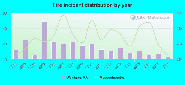 According to the data from the years 2002 - 2018 the average number of fire incidents per year is 16. The highest number of reported fires - 49 took place in 2005, and the least - 3 in 2018. The data has a declining trend.
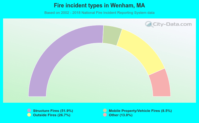 When looking into fire subcategories, the most incidents belonged to: Structure Fires (51.9%), and Outside Fires (26.7%).
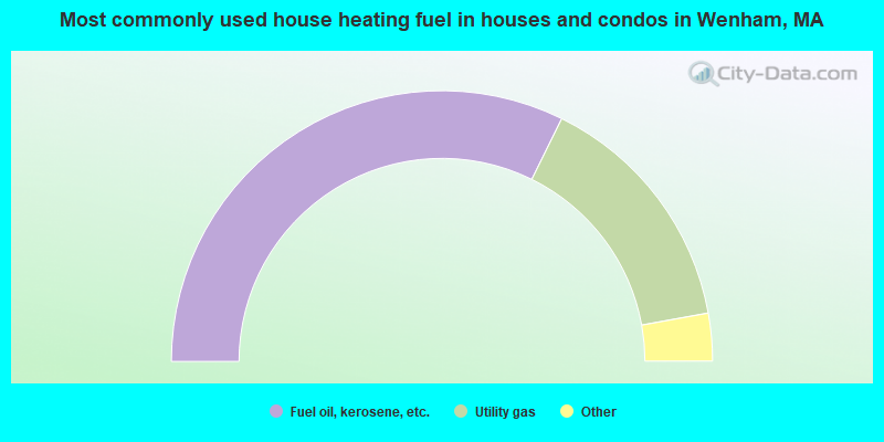
- 64.6%Fuel oil, kerosene, etc.
- 29.7%Utility gas
- 3.0%Electricity
- 1.6%Wood
- 1.0%Bottled, tank, or LP gas
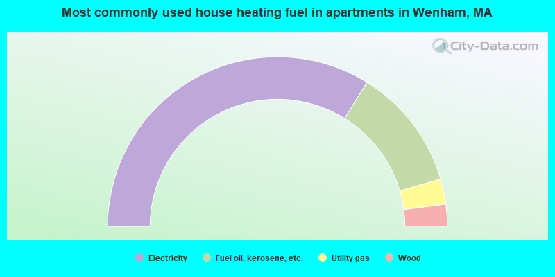
- 67.7%Electricity
- 23.3%Fuel oil, kerosene, etc.
- 4.8%Utility gas
- 4.2%Wood
Wenham compared to Massachusetts state average:
- Median household income above state average.
- Median house value above state average.
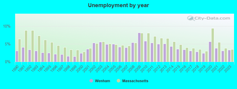
- Unemployed percentage above state average.
- Black race population percentage significantly below state average.
- Hispanic race population percentage significantly below state average.
- Median age significantly below state average.
- Foreign-born population percentage significantly below state average.
- Renting percentage significantly below state average.
- Length of stay since moving in significantly above state average.
- Number of rooms per house significantly below state average.
- House age significantly below state average.
- Number of college students above state average.
- Percentage of population with a bachelor's degree or higher above state average.
Wenham on our top lists:
- #18 on the list of "Top 100 cities with highest median household income and median resident age less than 35"
- #21 on the list of "Top 101 counties with the lowest percentage of residents that keep firearms around their homes"
- #21 on the list of "Top 101 counties with the most Orthodox adherents"
- #23 on the list of "Top 101 counties with the highest carbon monoxide air pollution readings in 2012 (ppm)"
- #30 on the list of "Top 101 counties with the most Catholic adherents"
- #36 on the list of "Top 101 counties with the most Orthodox congregations (pop. 50,000+)"

|
|
Total of 200 patent applications in 2008-2024.